Embed Size (px)
Citation preview

Preliminary Site Investigation- 148 Rouse Street, Tenterfield, NSW Page 1 of 56
August 2021
Lots A DP 150057, B 150057, 1 DP 516621, 33
DP 1138201
148 Rouse Street, Tenterfield, NSW, 2372 Tenterfield Shire Council
20095_COWAN_DSI
Prepared for Jack Thomas, Nutrien
Harcourts
Preliminary Site Investigation
Environmental Site History

Preliminary Site Investigation - 148 Rouse Street, Tenterfield, NSW Page 2 of 56
August 2021
Document control
Project Title: Rouse Street Tenterfield PSI ESH
Job Number 21299
Document Title Rouse Street, Tenterfield Site Investigation Report
Document number 21299_ROUSE_STREET_TENTERFIELD_PSI_ESH
Prepared for Jack Thomas, Nutrien Harcourts
Prepared by Ecoteam
Site Assessor and Report
Authors
Lise Bolton BSci , MEng,
Executive Summary
Revision Date Description Report Author/s
Internal Review
Approved for Issue
00 27/08/2021 Issued as Final
Lise Bolton Nick Crowley
Lise Bolton
Draft
Signatures
27/08/2021 Issued for Review
Lise Bolton Keith Bolton
Lise Bolton
13 Ewing Street, LISMORE NSW 2480 Australia
Phone: (02) 6621 5123 Fax: (02) 6621 8123 Email: [email protected] Web: www.ecoteam.com.au

Preliminary Site Investigation - 148 Rouse Street, Tenterfield, NSW Page 3 of 56
August 2021
Ecoteam has been engaged by Jack Thomas, Nutrien Harcourts to undertake a Phase 1
Preliminary Site Investigation (PSI) and Environmental Site History (ESH) assessment for
148 Rouse Street, Tenterfield. The site is approximately 5.65 ha and currently comprises of
a car dealership, mechanic, and panel beaters. The subject site is proposed to be
redeveloped to include a childcare centre, medical centre, and commercial shops.
This investigation has established potential sources of contamination associated with
current or past practices at the site which may pose a risk to future receptors during and
following the redevelopment of the site. Contamination is possible from leakage of oil and
fuel from the mechanic workshop and associated infrastructure. Leakages of fuel and oil
from cars housed on the site or chemical from other site uses (panel beating) may also be
present. Importation of contaminated fill may also have occurred at the site.
The CSM has identified potential health risks to future visitors and workers at the site
(children and adults). Based on the level of soil contact within the site, the child-care centre
site requires assessment as land use scenario ‘A’ low-density residential for contaminant
exposure risk assessment. This includes outdoor exposure. The remainder of the site has
been assessed as land use scenario ‘D’, Commercial. This land use provides contaminant
levels which assume mostly sealed surfaces. An ecological receptor exists to the west of
the site which receives stormwater from the site.
Further investigation is required including soil and surface water sampling to determine if
the site presents a potential risk to the future receptors at the site. Further soil sampling
shall include surface and under slab/bitumen sampling, depth sampling around underground
contamination sources (mechanical pit and wash down collection tank). Surface water
sampling at the site of the exposed drain will also provide information on potential water
contamination at the site. The further investigation should be carried out in accordance with
AS4482.1-2005 and the ASC NEPM.

Preliminary Site Investigation - 148 Rouse Street, Tenterfield, NSW Page 4 of 56
August 2021
Table of Contents
Document control ....................................................................................................................... 2
Executive Summary ..................................................................................................................... 2
1. Introduction ......................................................................................................................... 6
1.1. Project Outline ........................................................................................................................ 6
1.2. Site Identification .................................................................................................................... 6
1.3. Scope of Works ....................................................................................................................... 7
1.4. Objectives ............................................................................................................................... 8
1.5. Legislative Framework ............................................................................................................. 8
2. Site Conditions ..................................................................................................................... 9
2.1. Topography, Geology and Hydrology ....................................................................................... 9
2.2. Register Groundwater Bores and Water Use .......................................................................... 10
2.3. Environmental Sensitive sites ................................................................................................ 10
3. Site History ........................................................................................................................ 11
3.1. Land Use ............................................................................................................................... 11
3.2. Current Site Conditions.......................................................................................................... 11
3.3. Services and Underground Utilities ........................................................................................ 12
3.4. Site Walkover ........................................................................................................................ 12
3.5. Site History ........................................................................................................................... 13
3.6. Review of Aerial Photographs ................................................................................................ 13
3.7. Contamination History .......................................................................................................... 15
3.8. Previous Titles ....................................................................................................................... 15
4. Assessment Criteria ............................................................................................................ 16
4.1. Contaminants of Potential Concern (CoPC) ............................................................................. 16
5. Preliminary Conceptual Site Model .................................................................................... 18
5.1. Receptors and Pathways ....................................................................................................... 19
5.1.1. Sensitive Receptors ........................................................................................................... 20
5.1.2. Potential Exposure Pathways ............................................................................................. 20
6. Interpretation and data Gaps ............................................................................................. 22
7. Conclusion & Recommendations ........................................................................................ 23
8. References & Guidelines ..................................................................................................... 24

Preliminary Site Investigation - 148 Rouse Street, Tenterfield, NSW Page 5 of 56
August 2021
Appendix A Site map ............................................................................................................. 26
Appendix B Development Plans ............................................................................................. 28
Appendix C Groundwater Wells ............................................................................................. 30
Appendix D Sewage and DBYD .............................................................................................. 32
Appendix E Site Photographs ................................................................................................ 40
Appendix F Historical Photographs ........................................................................................ 45
Appendix G Subdivision Certificate ........................................................................................ 49
Appendix H Historical Land Maps .......................................................................................... 51
© 2021 Ecotechnology Australia Pty Ltd trading as Ecoteam
This document was prepared for the sole use of the party identified on the cover sheet, the only intended beneficiary
of Ecotechnology Australia Pty Ltd work. The use of this document by other stakeholders is only permitted with
written confirmation by the party identified on the cover sheet and Ecotechnology Australia Pty Ltd.
No other party should rely on the document without the prior written consent of Ecotechnology Australia Pty Ltd, and
Ecotechnology Australia Pty Ltd undertakes no duty to, nor accepts any responsibility to, any third party who may
rely upon this document.
All rights reserved. No section or element of this document may be removed from this document, extracted,
reproduced, electronically stored or transmitted in any form without the prior written permission of Ecotechnology
Australia Pty Ltd.

Preliminary Site Investigation - 148 Rouse Street, Tenterfield, NSW Page 6 of 56
August 2021
1. Introduction
1.1. Project Outline
Ecoteam has been engaged by Jack Thomas, Nutrien Harcourts to undertake a Phase 1
Preliminary Site Investigation (PSI)- Environmental Site History (ESH) assessment for the
Sexton and Green car dealership and mechanics and Panel Beaters on Rouse Street,
Tenterfield. The site is part of a development application with Tenterfield Shire Council to
be redeveloped to include a medical centre, childcare centre and commercial shops. This
assessment will identify potential contamination at the site which may affect its future land
use. This assessment will use historical and environmental searches and known site
conditions to develop a Conceptual Site Model (CSM), identify contaminants of Potential
Concern (CoPC) and assess if further information and/ or soil sampling is required.
1.2. Site Identification
Table 1 presents site details. Refer to Appendix A for site overview and detailed site plan
of the Investigation Area. Site location is marked in Figure 1.
Table 1. Site details of Cowan former service station
Feature Description
Address 148 Rouse Street, Tenterfield, NSW, 2372
Plan Number Lots A DP 150057, B 150057, 1 DP 516621, 33 DP 1138201.
Local Government Area Tenterfield Shire Council
Geographic Coordinates S -29.057071°, E 152.017890°
Investigation Area Approx. 5.65 ha
Current Zoning R5 Village
Proposed Development Day-care centre, medical centre commercial shops (Appendix B)

Preliminary Site Investigation - 148 Rouse Street, Tenterfield, NSW Page 7 of 56
August 2021
Figure 1. Site location. Site boundaries marked with red flag. Source: Six Maps Online
(NSW Spatial Services, NSW Department of finance and Service)
1.3. Scope of Works
The scope of works for this assessment was guided by CLM Act (1997), SEPP 55, OEH
(2011), NEPC (2013), AS 4482.1 (2005) and AS 4482.2 (1999). This scope of works
included:
1. Assess the regional topography, geology hydrology and hydrogeology. Assess the
potential for contamination migration.
2. Review Current and Historical site information including historical and current arial
photographs;
3. Review site historical practices including chemical handling and storage and
Undertake a desktop study to identify areas of concern from past practices;
4. Prepare a Conceptual Site Model (CSM) and assess Data Quality Objectives (DQO);
5. Prepare recommendation and final conclusions from interpretation of the Preliminary
Site Investigation.

Preliminary Site Investigation - 148 Rouse Street, Tenterfield, NSW Page 8 of 56
August 2021
1.4. Objectives
The objectives of this assessment are to:
1. Assess established databases including historical information to provide background
information for the site;
2. Identify potential contamination from site infrastructure;
3. Investigate all potential contamination sources and Contaminants of Potential
Concern (CoPC) based on site information and historical and current land use;
4. Develop a Conceptual Site Model to determine potential risks, receptors,
contaminant migration and exposure pathways;
5. Assess the adequacy of information available and determine the need for further
investigations.
1.5. Legislative Framework
The following legislative acts and guidelines have been referred to during the investigation
and interpretation processes:
• Managing Land Contamination: Planning Guidelines - SEPP55 - Remediation of Land (DPUA & NSW EPA, 1998).
• Section 105 of the Contaminated Land Management Act 1997 (CLM Act) (NSW Government, 1997a).
• Protection of the Environment Operations Act 1997 (POEO Act), (NSW Government, 1997b).
• Australian Standard (AS 4482.1- 2005) Guide to the investigation and sampling of sites with potentially contaminated soil (Part 1).
• Australian Standard (AS 4482.2- 1999) Guide to the sampling and investigation of potentially contaminated soil, Part 2: Volatile substances.
• Contaminated Sites – Sampling Design Guidelines (NSW EPA, 1995).
• Consultants Reporting on Contaminated Land- Contaminated Land Guidelines. (NSW EPA, 2020).
• National Environmental Protection (Assessment of Site Contamination) Measures 1999 - Amended 2013 (NEPC, 2013);
• Regional Policy for the Management of Contaminated Land (NRRC, 2007)
• Waste Classification Guidelines – Part 1: Classifying Waste (EPA, NSW, 2014)
• Contaminated Sites: Guidelines for NSW Site Auditor Scheme (DECC NSW, 2006).
• Guidelines on the Duty to Report Contamination under the Contaminated Land
Management Act 1997 (DECC NSW, 2015).
• Australian and New Zealand Guidelines for the Assessment and Management of
Contaminated Sites (ANZECC/NHMRC, 1992).
• Guidelines for the Assessment of On-site Containment of Contaminated Soil
(ANZECC, 1999).

Preliminary Site Investigation - 148 Rouse Street, Tenterfield, NSW Page 9 of 56
August 2021
2. Site Conditions
2.1. Topography, Geology and Hydrology
Table 2 contains a description of the regional topography, geology, hydrology and
hydrogeology.
Table 2. Topography, geology, soil landscape and hydrology
Feature Description
Topography
(DPIE 2021)
Site elevation: ~851-849 m AHD. Site slope to the south-west. The site contains a flat area within the eastern portion of the site which slope down to the western potion.
Geology
(NSW Geo Survey, 1969, DPIE 2021)
Tenterfield mass of Dundee Ademellite Porphyrite (Blue-grey medium to course grained).
Soil Landscape
(DPIE 2021)
Lucas Heights-Moderately deep (50–150 cm), hard setting Yellow Podzolic Soils and Yellow Soloths Yellow Earths on outer edges.
Hydrology
(NSW LPI, 2001 and commonwealth of Australia, 1987
An open drain is present on the western portion of the site. This drain collets stormwater for the site and surrounding areas. This drains forms as a tributary to Tenterfield Creek and runs through the subject site from the south-eastern corner to the north-western corner. The south-eastern corner runs underground. Tenterfield creek is present approximately
160 m to the north-west. Tenterfield dam is located 1.6 km to the south.
Groundwater
(NSW Office of Water 2014, Jacobson & Lau 1987)
Granite fracture rock of low to moderate productivity of the New England
Tablelands. Groundwater estimated at approximately 3 m depth.
Acid sulfate soil
(DPIE 2021)
Not present

Preliminary Site Investigation - 148 Rouse Street, Tenterfield, NSW Page 10 of 56
August 2021
2.2. Register Groundwater Bores and Water Use
Search of the Water NSW register database (Appendix B) shows 5 water bores are located
within 100 m of the subject site. Two of these bores are registered for stock/domestic use,
while three are registered as monitoring wells at the Mobil service station (70 m east of the
subject site). A further 7 bores are located within 500 m of the site. Table 3 presents the
detail of bores situated within 100 m of the site. The Tenterfield Village is connected to town
water supply, therefore limited domestic groundwater water use is expected in the
surrounding area. The site is not close to any local water supply areas.
Table 3. Groundwater wells within 100 m of the subject site
2.3. Environmentally Sensitive Sites
The park directly surrounding area is not consider enviromentally sensitive.mmediate i The
and is mainlynning purposes alpfor public open space is marked aswest of the subject site
west which contins-s. A creek is situated 160 m southegrasses withs some mature tre
mature trees and riparian vegetation. The creek is situated in a urban environemnt and is
idered ashall be cons areanot likley to be considered a highly sensitve environment. This
purposesment ecological receptor for assesseential pot.
Well ID
Position from
Subject
Site
Construction date
Use SWL Total depth
Estimated ADH
GW900213 70 m SW 1991 Domestic 1 m 21 m 853 m
GW970501
70 m NE 2010 Monitoring Bore
2.1 m 5.0 851 m
GW970502
70 m NE 2010 Monitoring Bore
3.1 m 4.5 m 851 m
GW970500
85 m NE 2010 Monitoring Bore
3.0 m 5.5 854 m
GW308356
170 m NE 2019 Domestic/stock 6 m 27m 856 m
Preliminary Site Investigation - 148 Rouse Street, Tenterfield, NSW Page 11 of 56
August 2021
3. Site History
3.1. Land Use
The subject site is situated on the corner of Rouse Street and Miles Street. Rouse Street
borders the southern side of the site. The Tenterfield Shopping Centre is neighbouring the
northern boundary of the site. Rouse Street is a considered a central commercial / shopping
area. The surrounding area consists of commercial land use including a shopping centre,
service station, information centre and various commercial shops. Residential dwellings and
a church are present directly south of the site across from Miles Street. A designated Public
Open Space is present along the western boundary which is grassed with some trees The
wider area surrounding the property includes residential, commercial, and public recreation
land uses. Surrounding land use is presented in Table 4.
Table 4. Surrounding land use
Orientation Land Use
North Village- Commercial
South Village- Commercial
East Village- Residential
West Village- Public recreational area (Open space)
3.2. Current Site Conditions
The site is currently a car dealership yard and mechanical workshop. The workshop includes
a welder, hoists, and drill presses. The Sexton and Green portion of the site contains a large
office building. A panel beaters workshop is present to the north-west of the subject site.
The site consists of a brick building with cement floor and tin roof. The site has two car
parking areas (north-east and south-west).
An open external drain runs underneath the site which is exposed within the south-western
corner of the site. The drain is a tributary to Tenterfield Creek to the east. The drain holds
water at times.
An internal drain is present within the workshop area which collected wash down water. This
water is then collected in a wastewater pit which is treated though an oil water separator
prior to being discharged into the council wastewater system. A mechanical pit is also
present at the site. There is potential for leakage of oil and fuel from these sites (Appendix
A). No asbestos was visually identified to be present on-site. The property contains
concrete, bitumen, grassed and exposed soil surfaces. The south-western car park area is

Preliminary Site Investigation - 148 Rouse Street, Tenterfield, NSW Page 12 of 56
August 2021
the only fenced potion of the site. The site contains a flat surface within the eastern potion
which drops down to the west. The site has some cars remaining in parking areas.
Contaminating Infrastructure has been identified on the site map in Appendix A.
Infrastructure identified (past and present) within the site:
• Mechanic Pit (4.3m x 1.2 m x 1.8 m deep)
• Wash down treatment pit (location unknown)
• Internal wash down drains
• Car parking area
3.3. Services and Underground Utilities
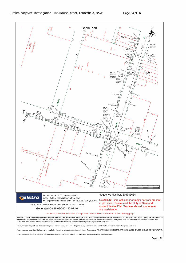
Main sewage in present running from the north to south though the northern carpark to the
Sexton and Green workshop area (Appendix C). A Dial Before You Dig (DBYD)
assessment of the site (Appendix C) has identified Telstra cables (including NBN
infrastructure) are present along the eastern and south boundary of the site within the
footpath area. Power poles are also located along the eastern, southern, and western
boundaries of the site. Further intrusive investigation at the site will require a competent
underground service locator to clear the underground infrastructure before undertaking soil
sampling and assessment.
3.4. Site Walkover
An Ecoteam representative was unable to attend the site at the time of this report due to a
Covid lockdown. A site assessment was undertaken by Jack Thomas of Nutrien Harcourts.
The site was investigated on the 24th August 2021 (Appendix D).
According to the site photographs (Appendix D) and discussions the sites external concrete
sand bitumen surfaces were in very good condition. Both buildings are also in good
condition. The Sexton and Green workshop area is currently in good condition and has
been kept tidy and clean with very limited oil stains present on the concrete surface. The
wash down drain is of new condition and has been replaced recently.
An external open drain is present running under the site from the south-eastern corner to
the north-western corner. A drain runs underground under the Sexton and Green building
site. The open portion of the drain had some vegetation and contained standing water.
There is grass present surrounding the drain. A bitumen driveway leads into the panel
beaters site.

Preliminary Site Investigation - 148 Rouse Street, Tenterfield, NSW Page 13 of 56
August 2021
3.5. Site History
The Rouse Street area in Tenterfield was expanded from 1900-1950. The subject site was
established as the Sexton and Green garage and car showroom in 1919. The Sexton and
Green dealership is one of oldest car dealership in Tenterfield.
The current Sexton and Green building was built in the early 1960s and was constructed of
brick, with a cement floor and tin roof. This building was then upgraded in the 1990s. The
front veneer was upgraded and repainted at this time.
The western workshop/shed was built in the late 1970s to early 1980s. This building was
also renovated in the 1990s. The site has historically been used as a car storge parking and
as a mechanics. Recently, the western workshop has been used as a panel beaters. Aerial
photographs reviewed from 1967 to present (Appendix F) have shown the main Sexton
and Green Building is present prior to 1967. The site and its surroundings are designated
as a heritage conservation area.
3.6. Review of Aerial Photographs
Aerial photographs from 1967 to 2021 were reviewed and summarised to investigate
previous land use within the subject site and the surrounding vicinity. Table 5 contains a
summary review of historic aerial photographs for the subject property and surrounding land.
(See Appendix F for historical images).
Table 5. Summary of historic aerial photographs.
Date Source Site
28/05/1967 NSW Historical Imagery
The photograph is black and white and of good quality The site The Sexton and Green building is present along the corner of Rouse Street and Miles Street. Some car parking is visible to the west. The area directly to the west of the Sexton and Green building is undeveloped. The north-western portion of the site is partially vegetated. The drain is present flowing to the north-west. Surrounding Land The site directly to the west is cleared and grassed. Some trees are present. Residential premises are present directly north, east and south of the site. Industrial/commercial premises are present further to the north.
3/04/1975 NSW Historical Imagery
The photograph is black and white and of poor quality The site The Sexton and Green building is present along the corner of Rouse Street and Miles Street. Some car parking is visible to the west. The area directly to the west of the Sexton and Green building is undeveloped. The north-western portion of the site is partially vegetated. The drain is present flowing to the north-west. Surrounding Land The site directly to the west is cleared and grassed. Some trees are present. Residential premises are present directly north, east and south of the site. Industrial/commercial premises are present further to the north. The site is largely unchanged from the previous Historical Image

Preliminary Site Investigation - 148 Rouse Street, Tenterfield, NSW Page 14 of 56
August 2021
1/08/1985 NSW Historical Imagery
The photograph is black and white and of poor quality The site The Sexton and Green Building is present along the corner of Rouse Street and Miles Street. Directly north of the building is clear and contains a concrete surface. Car parking is still visible to the west. A shed/building has been erected within the western portion of the site. The north-western portion of the still contains some vegetation. Surrounding Land The site directly to the west is cleared and grassed. Some trees are present. Residential premises are present directly north, east and south of the site. Industrial/commercial premises are present further to the north.
1993 Google Earth Image
The photograph is colour and of good quality The site The Sexton and Green building is present along the corner of Rouse Street and Miles Street. Directly north of the building is clear and contains a concrete surface. Cars are visible parked in this area. Car parking is visible to the west, taking up a small portion of this area. The western carpark is fenced. A shed/building is present within the western portion of the site The north-western portion of the site contains some vegetation and grass surfaces. Surrounding Land The site directly to the west is cleared and grassed. Some trees are present. Residential premises are present directly to the north, east and south of the site. Industrial/commercial premises are present further to the north. Some commercial land uses are visible across Rouse Street to the south.
2010 Google Earth Image
The photograph is colour and of good quality The site The Sexton and Green building is present along the corner of Rouse Street and Miles Street. Directly north of the building is clear and contains a concrete surface. Many cars are visible parked in this area. Car parking is visible to the west, this carpark has expanded further west. The western carpark is fenced. A shed/building is present within the western portion of the site. The north-western portion of the site has been cleared. Surrounding Land The site directly to the west is cleared and grassed. Some vegetation has been removed. A shopping centre is present directly north of the site. Residential premises are present directly to the south. Industrial/commercial premises are present further to the north and north-east. The areas north and northeast have expanded to include more commercial land uses. More commercial land use is viable further south.
2013 Google Earth
The photograph is colour and of good quality The site The Sexton and Green building is present along the corner of Rouse Street and Miles Street. Directly north of the building is clear and contains a concrete surface. Many cars are visible parked in this area. Car parking is visible to the west. The western carpark is fenced. A shed/building is present within the western portion of the site. The north-western portion of the site is cleared. Surrounding Land The site directly to the west is cleared and grassed. Some vegetation has been removed. A shopping centre is present directly north of the site. Residential premises are present directly to the south. Industrial/commercial premises are present further to the north and north-east and further south.
2021 Google Earth
The photograph is colour and of good quality The site The Sexton and Green building is present along the corner of Rouse Street and Miles Street. Directly north of the building is clear and contains a concrete surface. Some cars are visible parked in this area. Car parking is visible to the west. The western carpark is fenced. A shed/building is present within the western portion of the site. The north-western portion of the site is cleared. Surrounding Land The site directly to the west is cleared and grassed. A shopping centre is present directly north of the site. Residential premises are present directly to the south. Industrial/commercial premises are present further to the north and north-east and further south. The site is largely unchanged from the previous Historical Image

Preliminary Site Investigation - 148 Rouse Street, Tenterfield, NSW Page 15 of 56
August 2021
3.7. Contamination History
No known previous continuation assessments have been conducted at the site. A Search
of NSW Contaminated Lands Records show only one site is present within the Tenterfield
Shire (Former Arsenic Factory Duke and Manor Street, Tenterfield). The site is no listed on
the NSW EPA List of notified Sites. The United Tenterfield Service Station (94 Rouse Street)
is a listed site which is currently under investigation.
3.8. Previous Titles
A prior Title search was conducted via the NSW Land & Property information website for
the subject property (Table 6). The Subdivision Certificate which was issued in 2008 is
presented in Appendix F. Historical land parish maps are located in Appendix G which
shows the site as 1 lot in the early 1900s owned by J Witten. The subject property was
shown to be subdivided within the 1958 historical maps.
Table 6. Title search details.
Current title (2021)
Previous titles
Date 1/516621 12915-227
Lot and DP 1/1113227 1/350046, 4/22/758959
32/1138201 2/851417, 3/587603
A/150057 12350-237
B/150057 4599-26

Preliminary Site Investigation - 148 Rouse Street, Tenterfield, NSW Page 16 of 56
August 2021
4. Assessment Criteria The key assessment criteria adopted in the assessment of contamination is the National
Environmental Protection (Assessment of Site Contamination) Measure 2013 (NEPC,
2013). Schedule B1 provides contaminant exposure levels which can be used to assess risk
of contamination to human and ecological receptors. Health Investigation Levels (HILs),
Health Screening levels (HSLs), Ecological Screening Levels (ESLs) and Ecological
Investigation Levels (EILs) may be adopted from the measure to determine the likely human
and ecological health impacts of soil contamination and any further investigation required.
Management limits are also adopted for petroleum hydrocarbons. Water quality within
groundwater is compared with Groundwater Investigation Level (GIL) threshold
contamination limits.
HILs provide assessment criteria for indicators of risk for direct contact and therefore are
important for determining immediate risk. HSLs are applicable to assessing human health
risk through inhalation, ingestion or direct contact pathways and are site dependent. EILs
and ESLs assess the direct risk to terrestrial ecosystems and are only applicable to the top
2 m of soil. This assessment criteria will be used as a reference to indicate the potential for
soil contamination. Management limits identify the need for further investigation but do not
imply contamination risk.
GILs are based on marine and freshwater groundwater quality assessment criteria which
are adapted from the Australian and New Zealand Guidelines for Fresh and Marine Water
Quality ANZECC/ARMCANZ 2000 (ANZECC 2000). This guideline outlines water quality
objectives for the protection of aquatic ecosystems. These values do not imply an
environmental problem but are intended as trigger values in which further assessment may
be required. GILs for drinking water assessment criteria are adapted from the Australian
Drinking Water Guidelines (ADWG, NHMRC 2011). Drinking water criteria are provided as
a reference only.
4.1. Contaminants of Potential Concern (CoPC)
Current land-use indicates there may be potential for land contamination within the subject
site. Contamination is possible from leakage of oil and fuel from the mechanic workshop
associated infrastructure. Leakages of fuel and oil from cars housed on the site or chemical
from other site uses (panel beating) may also be present. Importation of contaminated fill
may also have occurred at the site. Soil will be tested for contaminants of potential concern
(CoPC) from car storage and mechanics which include:
• Total recoverable hydrocarbons (TRH) (C6 to C40)
• Benzene, toluene, ethylbenzene and xylenes (BTEX)
• Naphthalene
• Metals
• VOCs
• PAH Secondary contaminants that may be associated with other activities carried out on
workshop areas sites include:

Preliminary Site Investigation - 148 Rouse Street, Tenterfield, NSW Page 17 of 56
August 2021
• Polycyclic aromatic hydrocarbons (PAH) from oil and fuel and workshop activities.
• Heavy metals (As, Cd, Cr, Cu, Ni, Pb, Zn), phenols from workshop activities.
• BTEX compound from paints and workshop chemicals.
• VOCs from oil and fuels.
• PFAS within drainage lines.
• Organochlorine pesticides (OCP) and heavy metals used under slabs.
• Heavy metals and TRH associated with imported fill material.
The service station across the road may also be an off-site source of contamination.

Preliminary Site Investigation - 148 Rouse Street, Tenterfield, NSW Page 18 of 56
August 2021
5. Preliminary Conceptual Site Model
A preliminary Conceptual Site Model (CSM) identified pathways and receptors of CoPC
within the Areas of Environmental Concern (AEC). AEC are defined as any area in which
past potentially contaminating activities may have been conducted.
Table 7 shows information on AEC and CoPCs which were tested at the site. Table 8
presents contamination sources, AEC, activity of concern and CoPC characterisation.
Table 7. AEC, activities of concern and CoPC
I.D AEC Activity of
concern CoPC Comments
Mechanic
Workshop
Oil and fuel collection and disposal
Oil, diesel and leaded fuel storage and dispensing
TRH, BTEXN, metals, PAH, VOCs phenols
Contaminant of oil, diesel and leaded fuel and oils. Volatile substances may also be present.
Workshops/
panel
beaters
Workshop (past and present) and area of washdown
Wash down of fuel oil and chemicals in workshop, oil collection and treatment
TRH, BTEXN, metals, PAH, phenols
Contaminant of diesel leaded and unleaded fuel and oils, metals form chemical use and phenolic compounds may be present within the soil.
Concrete
areas
All concreted or bitumen surfaces
Chemical treatment and metals for pesticide treatment
TRH, BTEXN, metals,
Contaminant of metals and pesticides may be present in the top surface of the soil directly under the slab.
Drain Drainage from commercial areas
Stormwater and shallow groundwater runoff from the site and surrounding commercial areas
TRH, BTEXN, metals, PFAS
PFAS may be present within drainage lines. Stormwater and shallow groundwater may have commination from leaking pits or site activities.

Preliminary Site Investigation - 148 Rouse Street, Tenterfield, NSW Page 19 of 56
August 2021
Table 8. Potential contamination sources and transport mechanisms
5.1. Receptors and Pathways
The area of investigation is a car dealership, mechanic and panel beaters which will be
demolished and developed into a day-care centre, medical centre and commercial shops.
Based on the level of soil contact within the AEC, the childcare centre site will be assessed
as land use scenario ‘A’ low-density residential’ for contaminant exposure risk assessment.
This includes outdoor exposure. The remainder of the site will be assessed as land use
scenario D “Commercial”. This land use provides contaminant levels which assume mostly
sealed surfaces.
AEC Primary Sources Secondary
Sources Transport mechanisms
Mechanic
Workshop
-Leaking pits and oil collection tank (>2m) -Leaking drain (0-0.3m) -Fill material -Surface spills
Impacted surface soil (0-0.3m) Impacted sub-surface soil (0.3m+) NAPL plume migration in groundwater Impacted stormwater
Volatilisation and atmospheric dispersion of dusts and vapours Soil and contaminant particle movement Mobile free phase hydrocarbon or chemical migration Flood/storm migration Groundwater migration
Workshop/
panel
beaters
-Wash down water (0-0.15m) --Fill material -Surface spills
Impacted surface soil (0-0.3m) Impacted sub-surface soil (0.1m+) Chemical migration in groundwater
Volatilisation and atmospheric dispersion of dusts and vapours Soil and contaminant particle movement Mobile free phase hydrocarbon or chemical migration Groundwater migration
Car parking
Area
-Chemical application during laying of the concrete. Oil, fuel, and chemical spills. (0-0.3m)
Impacted surface soil (0-0.3m)
Soil dispersion during removal of the slab.
Drain -Contaminants from stormwater (0-0.3m), Water contamination
Impacted surface soil (0-0.3m). Impacted surface water
Flood/storm migration Groundwater migration

Preliminary Site Investigation - 148 Rouse Street, Tenterfield, NSW Page 20 of 56
August 2021
5.1.1. Sensitive Receptors
Sensitive receptors have been identified within the vicinity of the site.
• Future construction personnel during excavation work.
• Children within the day-care centre.
• Visitors to the medical centre and shopping area.
• Future workers at the site.
• Residential dwellings surrounding the site.
• Ecological receptors towards the west of the site.
• Visitors to the recreational area west of the site.
5.1.2. Potential Exposure Pathways
Contamination has been identified as being potentially present in soil within the AEC due to
past activities. The main CoPC have been identified as TRH, BTEXN, PAH, PCB and
metals. Exposure pathways of these contaminants in soil include direct contact, inhalation
of vapours and ingestion of soil particles through dust or eating of soil. Table 9 provides a
risk assessment of potential exposure pathways for receptors at the site.

Preliminary Site Investigation - 148 Rouse Street, Tenterfield, NSW Page 21 of 56
August 2021
Table 9. Receptor and pathway risk assessment
Source Pathway Risk
Contamination from
mechanics and
workshop
Hu
ma
n h
ealt
h
Ingestion of soil and
inhalation of dust
particles.
High risk. Soil particles may be ingested
as dust particles. Soil particles may be
directly ingested, particularly by young
children. Risk is high for the childcare
centre with direct access to soil. Inhalation
exposure associated with particulates are
considered of less significance than direct
ingestion of soil.
Ingestion of
contaminated water
Minor risk. Tenterfield has a reticulated water mains supply. Based on this it is considered unlikely that a groundwater will present a risk.
Inhalation/Vapour
intrusion
Minor risk. Naphthalene and volatile
hydrocarbons (C6-C16) may be present.
Groundwater may be contaminated if
mechanical washdown collection tanks
have leaked. Vapour intrusion presents a
risk for future staff and visitors. Minor risk
due to limited storage of volatile chemicals
stored onsite.
Dermal absorption Minor risk. At most risk to future
construction personnel during excavation
work. Dermal adsorption of most
chemicals potentially present are low.
Ec
olo
gic
al
Surface runoff to
waterways. Infiltration
to groundwater.
Moderate risk. A drainage area and creek
exist towards the west of the site. A
groundwater plume or migration though the
drain on-site may be possible due to the
water table and close proximity to drainage
lines.
Direct uptake from
ecological receptors
Minor risk. An open ecological area
exists towards the west of the site. The is
limited ecological receptors to the west of
the site. Contamination is unlikely to spread
to this site.

Preliminary Site Investigation- 148 Rouse Street, Tenterfield, NSW Page 22 of 56
6. Interpretation and Data Gaps
The results of the desktop ESH has been evaluated for data gaps as per Schedule B2 of
the NEPM guidelines.
The following data gaps have been identified during the assessment.
• A site assessment conducted by a specialist is required to ensure that all potential
contaminant sources are identified.
• The exact construction date of the building and the prior conditions of the site in the
past has not been fully established.
• Exact concentrations of contaminants within the soil at the site are unknown and
therefore soil sampling is a data gap which needs to be addressed.
• All past land uses for the for the workshop structure (current panel beaters) is
unknown.
• Contamination status within water (surface or groundwater) at the site is unknown.
Based on these data gaps it is considered that uncertainty as to the contamination status of
the site. Therefore, further site assessment and soil sampling is required to further assess
the risk posed to the future receptors at the site.

Preliminary Site Investigation - 148 Rouse Street, Tenterfield, NSW Page 23 of 56
August 2021
7. Conclusion & Recommendations
A Preliminary Site Investigation which includes an Environmental Site History has been
conducted for 148 Rouse Street, Tenterfield. The site is approximately 5.65 ha and currently
comprises of a car dealership, mechanic, and panel beaters. The subject site is proposed
to be redeveloped to include a childcare centre, medical centre, and commercial shops.
This investigation has established potential sources of contamination associated with
current or past practices at the site which may pose a risk to future receptors during and
following the redevelopment of the site. Contamination is possible from leakage of oil and
fuel from the mechanic workshop and associated infrastructure. Leakages of fuel and oil
from cars housed on the site or chemical from other site uses (panel beating) may also be
present. Importation of contaminated fill may also have occurred at the site.
The CSM has identified potential health risks to future visitors and workers at the site
(children and adults). Based on the level of soil contact within the site, the child-care centre
site requires assessment as land use scenario ‘A’ low-density residential for contaminant
exposure risk assessment. This includes outdoor exposure. The remainder of the site
requires assessed as land use scenario ‘D’, Commercial. This land use allows for
contaminant levels assuming mostly sealed soil surfaces. An ecological receptor exists to
the west of the site which receives stormwater from the site.
Further investigation is required including soil and surface water sampling to determine if
the site presents a potential risk to the future receptors at the site. Further soil sampling
shall include surface and under slab/bitumen sampling, depth sampling around underground
contamination sources (mechanical pit and wash down collection tank). Surface water
sampling at the site of the exposed drain will also provide information on potential water
contamination at the site. The further investigation should be carried out in accordance with
AS4482.1-2005 and the ASC NEPM.

Preliminary Site Investigation - 148 Rouse Street, Tenterfield, NSW Page 24 of 56
August 2021
8. References & Guidelines
Australian Standard AS4482.1, (2005). Guide to the investigation and sampling of sites with
potentially contaminated soil (Part 1: Non-volatile and semi-volatile compounds).
Australian Standard AS4482.2, (1999). Guide to the investigation and sampling of sites with
potentially contaminated soil (Part 2: Volatile substances).
Australian Standard AS5667.11, (1998). Water quality—sampling. Part 11: Guidance on
sampling of groundwater’s.
Clements, L., Palaia, T., and Davis, J (2009). Characterisation of sites impacted by
petroleum hydrocarbons- National guideline document. CRC CARE Technical report no. 11.
CRC Care (2017). Risk-based management and remediation guidance for benzo(a)pyrene.
Technical report no. 39.
Department of Planning, Industry and Environment (DPIE), (2021). eSPADE. NSW Soil and
Land Information System (SALIS). https://www.environment.nsw.gov.au/eSpade2Webapp
Accessed 22/03/2021
Friebel, E. and Nadebaum, P. (2011a). Health screening levels for petroleum hydrocarbons
in soil and groundwater. Part 1: Technical development document. CRC CARE Technical
report no. 10.
Friebel, E. and Nadebaum, P. (2011b) Health screening levels for petroleum hydrocarbons
in soil and groundwater. Part 2: Application document. CRC CARE Technical report no. 10.
Friebel, E. and Nadebaum, P. (2011c). Health screening levels for petroleum hydrocarbons
in soil and groundwater. Part 3: Sensitivity assessment. CRC CARE Technical report no.
10.
Jacobson, G. & Lau, J.E (1987). Hydrology of Australia (1:5000000 scle map). Bureau of
Minerals and Resources, Canberra.
National Environmental Protection Council (NPEC) Measure, (2013a). Schedule B (1) –
Guidelines on the Investigation Levels for Soil and Groundwater
National Environmental Protection Council (NPEC) Measure, (2013b). Schedule B (2) –
Guidelines on Data Collection, Sample Design and Reporting.
Preliminary Site Investigation - 148 Rouse Street, Tenterfield, NSW Page 25 of 56
August 2021
National Environmental Protection Council (NPEC) Measure, (2013a). Schedule B (7a) –
Guidelines on Health-Based Investigation Levels.
New South Wales Office of Environmental Protection Authority (NSW EPA) (2020)
Consultants Reporting on Contaminated Land- Contaminated Land Guidelines.
New South Wales Environmental Protection Authority (NSW EPA), (1995). Contaminated
sites- Sample design guidelines.
New South Wales Environmental Protection Authority (NSW EPA), (2014). Technical note:
Investigation of Service Station Sites.
Office of Environment and Heritage (OEH) (2006) Contaminated Sites – Guidelines for the
NSW Site Auditor Scheme (2nd edition).
Tenterfield Shire Local Heritage Register 1 of 2. Final assessment list, November 17, 2004

Preliminary Site Investigation - 148 Rouse Street, Tenterfield, NSW Page 26 of 56
August 2021
Appendix A
Site map

Preliminary Site Investigation- 148 Rouse Street, Tenterfield, NSW Page 27 of 56

Preliminary Site Investigation- 148 Rouse Street, Tenterfield, NSW Page 28 of 56
Appendix B
Development Plans

Preliminary Site Investigation- 148 Rouse Street, Tenterfield, NSW Page 29 of 56

Preliminary Site Investigation- 148 Rouse Street, Tenterfield, NSW Page 30 of 56
Appendix C
Groundwater Wells

Preliminary Site Investigation- 148 Rouse Street, Tenterfield, NSW Page 31 of 56
500 m radius

Preliminary Site Investigation- 148 Rouse Street, Tenterfield, NSW Page 32 of 56
Appendix D
Sewage and DBYD

Preliminary Site Investigation- 148 Rouse Street, Tenterfield, NSW Page 33 of 56
Preliminary Site Investigation- 148 Rouse Street, Tenterfield, NSW Page 34 of 56

Preliminary Site Investigation - 148 Rouse Street, Tenterfield, NSW Page 35 of 56
August 2021

Preliminary Site Investigation - 148 Rouse Street, Tenterfield, NSW Page 36 of 56
August 2021

Preliminary Site Investigation - 148 Rouse Street, Tenterfield, NSW Page 37 of 56
August 2021

Preliminary Site Investigation - 148 Rouse Street, Tenterfield, NSW Page 38 of 56
August 2021

Preliminary Site Investigation- 148 Rouse Street, Tenterfield, NSW Page 39 of 56

Preliminary Site Investigation- 148 Rouse Street, Tenterfield, NSW Page 40 of 56
Appendix E
Site Photographs

Preliminary Site Investigation- 148 Rouse Street, Tenterfield, NSW Page 41 of 56
Plate A- 24/08/2021 Wester Workshop (Panel beaters). View Northern western corner of the site looking east.
Plate B- 24/08/2021 Sexton and Green building. South-eastern corner. Looking north.
Plate C- 24/08/2021 Sexton and Green building and north-eastern car park. Looking west

Preliminary Site Investigation - 148 Rouse Street, Tenterfield, NSW Page 42 of 56
August 2021
Plate D- 24/08/2021 Sexton and Green building and north-eastern car park. Looking south.
Plate E- 24/08/2021 Sexton and Green building- offices/show room.
Plate F- 24/08/2021 Sexton and Green building- offices/show room.

Preliminary Site Investigation - 148 Rouse Street, Tenterfield, NSW Page 43 of 56
August 2021
Plate G- 24/08/2021 Sexton and Green building. Mechanic. Hoists.
Plate H- 24/08/2021 Sexton and Green building. Mechanics. Storage.
Plate I- 24/08/2021 Sexton and Green building. Mechanics. Storage.

Preliminary Site Investigation - 148 Rouse Street, Tenterfield, NSW Page 44 of 56
August 2021
Plate J- 24/08/2021 Sexton and Green building. Mechanics. Office space.

Preliminary Site Investigation - 148 Rouse Street, Tenterfield, NSW Page 45 of 56
August 2021
Appendix F
Historical Photographs

Preliminary Site Investigation- 148 Rouse Street, Tenterfield, NSW Page 46 of 56
Plate K (1967) Aerial View: Spatial viewer, 148 Rouse Street, Tenterfield.
AEC red circle
Plate L (1975) Aerial View: Spatial viewer, 148 Rouse Street, Tenterfield.
AEC red circle.
Plate M (1985) Aerial View: Spatial viewer, 148 Rouse Street, Tenterfield.
AEC red circle.

Preliminary Site Investigation - 148 Rouse Street, Tenterfield, NSW Page 47 of 56
August 2021
`
Plate N (1993) Aerial View: Spatial viewer, 148 Rouse Street, Tenterfield.
AEC red circle.
Plate O (2010) Aerial View: Google Earth, 148 Rouse Street, Tenterfield.
AEC red circle.
Plate P (2013) Aerial View: Google Earth, 148 Rouse Street, Tenterfield.
AEC red circle.

Preliminary Site Investigation - 148 Rouse Street, Tenterfield, NSW Page 48 of 56
August 2021
Plate Q (2021) Aerial View: Google Earth, 148 Rouse Street, Tenterfield.
AEC red circle.

Preliminary Site Investigation - 148 Rouse Street, Tenterfield, NSW Page 49 of 56
August 2021
Appendix G
Subdivision Certificate

Preliminary Site Investigation- 148 Rouse Street, Tenterfield, NSW Page 50 of 56

Preliminary Site Investigation- 148 Rouse Street, Tenterfield, NSW Page 51 of 56
Appendix H
Historical Land Maps

Preliminary Site Investigation - 148 Rouse Street, Tenterfield, NSW Page 52 of 56
August 2021

Preliminary Site Investigation - 148 Rouse Street, Tenterfield, NSW Page 53 of 56
August 2021

Preliminary Site Investigation - 148 Rouse Street, Tenterfield, NSW Page 54 of 56
August 2021

Preliminary Site Investigation- 148 Rouse Street, Tenterfield, NSW Page 55 of 56

Preliminary Site Investigation- 148 Rouse Street, Tenterfield, NSW Page 56 of 56


