Embed Size (px)
Citation preview

Journal of Biogeography,
27
, 521–554
© 2000 Blackwell Science Ltd
Blackwell Science, Ltd
Pollen-based biomes for Beringia 18,000, 6000 and 0
14
C yr
BP
†
M. E. Edwards
1
, P. M. Anderson
2
, L. B. Brubaker
3
, T. A. Ager
4
, A. A. Andreev
5
, N. H. Bigelow
6
, L. C. Cwynar
7
, W. R. Eisner
8
, S. P. Harrison
9,10
, F.-S. Hu
11
, D. Jolly
9,10
, A. V. Lozhkin
12
, G. M. MacDonald
13
, C. J. Mock
14
, J. C. Ritchie
15
, A. V. Sher
16
, R. W. Spear
17
, J. W. Williams
18,19
and G. Yu
10,20 1
Department of Geography, NTNU, N-7491 Trondheim, Norway,
2
Quaternary Research Center AK-60, University of Washington, Seattle, WA 98195, USA,
3
College of Forest Resources AR-10, University of Washington, Seattle, WA 98195, USA,
4
U.S. Geological Survey, Box 25046, M.S. 980, Denver Federal Center, Denver, CO 80225, USA,
5
Alfred Wegener Institute for Polar and Marine Research, Telegrafenberg A43, D-14473 Potsdam, Germany,
6
Alaska Quaternary Center, PO Box 756960, University of Alaska Fairbanks, Fairbanks, AK 99775–6960, USA,
7
Department of Biology, University of New Brunswick, Fredericton, NB, Canada E3B 6E1,
8
Department of Geography, University of Cincinnati, Cincinnati, OH 45221, USA,
9
Max Planck Institute for Biogeochemistry, Box 100164, D-07701 Jena, Germany,
10
Dynamic Palaeoclimatology, Lund University, Box 117, S-221 00 Lund, Sweden,
11
Departments of Plant Biology and Geology, University of Illinois, Urbana, IL 61801, USA,
12
Russian Academy of Science, Far East Branch, N.E. Interdisciplinary Research Institute, Magadan 68500, Russia,
13
Department of Geography, University of California—Los Angeles, Los Angeles, CA 90095–1524, USA,
14
Department of Geography, University of South Carolina, Columbia, SC 29208, USA,
15
Pebbledash Cottage, Corfe, Taunton TA3 7AJ, UK,
16
Severtsov Institute of Ecology and Evolution, Russian Academy of Sciences, 33 Leninskiy Prospect, 117071 Moscow, Russia,
17
Department of Biology, SUNY College Geneseo, Geneseo, NY 14454, USA,
18
Department of Geological Sciences, Brown University, Providence, RI 02912, USA,
19
National Center for Ecological Analysis and Synthesis, 735 State St., Suite 300, Santa Barbara, CA 93101, USA,
20
Department of Geo and Ocean Sciences, University of Nanjing, Nanjing 210093, China
Abstract
The objective biomization method developed by Prentice
et al
. (1996) for Europe wasextended using modern pollen samples from Beringia and then applied to fossil pollendata to reconstruct palaeovegetation patterns at 6000 and 18,000
14
C yr
bp
.The predicted modern distribution of tundra, taiga and cool conifer forests in Alaska and
north-western Canada generally corresponds well to actual vegetation patterns, althoughsites in regions characterized today by a mosaic of forest and tundra vegetation tend tobe preferentially assigned to tundra. Siberian larch forests are delimited less well, probablydue to the extreme under-representation of
Larix
in pollen spectra.The biome distribution across Beringia at 6000
14
C yr
bp
was broadly similar to today,with little change in the northern forest limit, except for a possible northward advancein the Mackenzie delta region. The western forest limit in Alaska was probably east ofits modern position.
At 18,000
14
C yr
bp
the whole of Beringia was covered by tundra. However, theimportance of the various plant functional types varied from site to site, supporting theidea that the vegetation cover was a mosaic of different tundra types.
Correspondence: Professor Mary Edwards, Department of Geography, NTNU, N-7491 Trondheim, Norway. E-mail: [email protected]† PALE/PARCS publication number 146.
JBI426.fm Page 521 Wednesday, November 15, 2000 3:48 PM

522 M. E. Edwards
et al
.
© Blackwell Science Ltd 2000,
Journal of Biogeography
,
27
, 521–554
Keywords
Pollen data, plant functional types, biomes, vegetation changes, climate changes, Alaska,
eastern Siberia, mid-Holocene, last glacial maximum.
INTRODUCTION
The northern high latitudes play a crucial role in the climatesystem. High-latitude climates are especially sensitive to majorchanges in boundary conditions, such as solar radiation andconcentrations of greenhouse gases (Bartlein
et al.
, 1992;Watson
et al.
, 1998). This sensitivity is viewed primarily as theresult of strong albedo feedback associated with changes in snowand sea-ice cover (Kutzbach & Gallimore, 1988; TEMPO,1996; Washington & Meehl, 1996). Another potentiallypowerful climatic feedback is related to changes in the com-position and distribution of high-latitude vegetation, particu-larly the location of the forest–tundra boundary, whichacts in synergy with the sea-ice feedback to amplify climaticwarming or cooling (Foley
et al.
, 1994; Melillo
et al.
, 1996;TEMPO, 1996; Texier
et al.
, 1997). Records of past large-scale vegetation changes in the Arctic and sub-Arctic are there-fore important for testing the performance of: (1) atmosphericgeneral circulation models (AGCMs) in a key region and(2) coupled models that attempt to include physical inter-actions among the atmosphere, oceans and vegetation (Foley
et al.
, 1998; Kubatzki
et al.
, 1998).High-quality late-Quaternary palaeovegetation records
are relatively scarce in many parts of the far north due to acomplex glacial history, the discontinuous nature of non-lacustrine deposits, low lacustrine sedimentation rates, lowpollen productivity, and the logistical challenges of workingin remote areas (Lamb & Edwards, 1988). However, Beringia(north-western Canada, Alaska and north-eastern Russia) isrelatively well studied; for decades there has been broadinterdisciplinary interest in the biologically critical ‘BeringLand Bridge’ that linked Asia and North America (Hopkins,1967; Hopkins
et al.
, 1982; West, 1997). Furthermore, Beringiawas largely unglaciated during the Quaternary and has severalcontinuous records extending to and beyond the last glacialmaximum. Thus, palaeoecological records from Beringia canmake an important contribution to understanding the dynamicsof climate in the Arctic.
The link between vegetation and climate at large spatialscales has encouraged the development of global vegetationmodels (e.g. Prentice
et al.
, 1992; VEMAP Members, 1995;Haxeltine & Prentice, 1996; Neilson
et al.
, 1998) which canbe used to translate the output of AGCMs into maps of present(potential), future, or past vegetation (e.g. Prentice
et al.
, 1992;Harrison
et al.
, 1995; VEMAP Members, 1995; Harrison
et al.
, 1998; Kutzbach
et al.
, 1998; Neilson
et al.
, 1998). Thesimulated vegetation distribution can be compared withmodern vegetation maps (e.g. Prentice
et al.
, 1992) or, in thecase of past vegetation, reconstructions based on pollen andplant-macrofossil data (e.g. Harrison
et al.
, 1998; Jolly
et al.
,
1998). For this to be done effectively requires that palaeo-vegetation data are organized in a way that is compatiblewith model output. The aim of the BIOME 6000 project(Prentice & Webb, 1998) is to translate fossil pollen assem-blages into a form that allows such direct data-model com-parison. In the method devised by Prentice
et al
. (1996) pollentaxa are assigned to one or more plant functional types(PFTs), which may then be combined to define biomes accord-ing to an explicit algorithm; the resultant biome assignmentscan be compared with biomes simulated by the vegetationmodel. The biomization method has been tested and appliedin a number of different regions (e.g. Prentice
et al.
, 1996;Jolly
et al.
, 1998; Prentice
et al.
, 1998; Tarasov
et al.
, 1998;Yu
et al.
, 1998; other articles in this issue), and it appears toprovide robust results across a wide range of climates andvegetation types.
In this paper we apply the biomization method (Prentice
et al.
, 1996) to reconstruct the biomes across Beringia for 0,6000, and 18,000
14
C yr
bp
, and discuss the implications ofthe results for our understanding of vegetation and climatechanges in this region.
STUDY REGION
Beringia (here defined as the area between 130
°
W and125
°
E, and from 53
°
to 75
°
N), extends westward from thelower Mackenzie Valley in Canada to the Verkhoyansk Rangeof eastern Siberia, and from the New Siberian Islands of theRussian Arctic to the Pacific Rim. The topography of easternBeringia (Alaska and north-western Canada) is dominatedby the generally east–west trending Brooks Range in thenorth and the Alaska, Wrangell-St. Elias, and Coast Rangesin the south. Interior Alaska is a region of large tectonicbasins and extensive uplands, with the Yukon-Kuskokwimlowland lying to the south-west. Far northern Alaska ischaracterized by the Arctic coastal plain. Uplands dominatemost of north-western Canada, with the exception of thelower Mackenzie region and the Toktoyuktok Peninsula.Western Beringia (north-east Siberia) is topographicallycomplex. The upper Indigirka and Kolyma drainages, andKamchatka, are mountainous; the Chukchi and KoryakUplands dominate the eastern part of the region. However,extensive lowlands occupy the northern coastal plain (Yana-Indigirka-Kolyma lowland) and south-eastern Chukotka(Anadyr Penzhina lowland). Although areas of easternBeringia bordered the continental and cordilleran ice sheets,much of Beringia remained ice-free during the last glacialmaximum (Hamilton & Thorson, 1983; Porter
et al.
, 1983;Ananyeyev
et al.
, 1993). The most extensive glaciation was ofthe southern mountains and adjacent lowland of south-central
JBI426.fm Page 522 Wednesday, November 15, 2000 3:48 PM

Biome reconstructions for Beringia 523
© Blackwell Science Ltd 2000,
Journal of Biogeography
,
27
, 521–554
Alaska. Glaciers were restricted to valleys in the mountain-ous areas of western Beringia and the Brooks Range ofnorthern Alaska.
Modern regional climate
Beringia is not as geographically coherent as its recentcommon history might imply. Climate (and vegetation) varyconsiderably across the region today—and presumably havedone so in the past. Winter climate is influenced by vari-ations of the East-Asian mid-tropospheric trough-ridge system.A strong upper-level trough is centred south of Beringia offeastern China and traverses through central Canada (Harman,1991). North of the trough, in western Beringia, the Siberiansurface high pressure system is prominent due to intensiveradiational cooling (Lydolph, 1977) and creates a cold, north-westerly flow into north-east Asia, thus greatly restrictingmaritime influence (Mock
et al.
, 1998). January temperaturesrange from below –40
°
C in the interior valleys to around–17
°
C along the eastern Siberian coast (WMO, 1979, 1981).Another cold-core high occurs over north-western Canada.January temperatures are
c.
–30
°
C in north-eastern Alaskaand
c.
–15
°
C along the south-west Alaskan coast.High solar radiation explains much of the summer peak in
the annual temperature cycle, although subtropical high pres-sure systems that dominate the mid-latitudes advect warmair from the south into both eastern and western Beringiaduring the summer (Mock
et al.
, 1998). Over western Beringia,average July temperatures are somewhat warmer along theeastern coast (
c.
12
°
C) compared with inland and farthernorth (
c.
5–10
°
C), because the East Asian trough is oftencentred over eastern Siberia bringing relatively cold air fromthe north (Moritz, 1979; Mock
et al.
, 1998). Average Julytemperatures for eastern Beringia generally exhibit a north-south gradient of increasing temperature (5–15
°
C; WMO,1979, 1981), but some west-east gradients exist due to theinfluence of the Bering Sea. The highest temperatures occurin the eastern interior of Alaska.
Precipitation across Beringia is low during winter; manylocations receive < 25 mm on average during January (WMO,1979, 1981). Higher precipitation in south-eastern Russiaresults from occasional winter storms that move up the coast-line from China (Terada & Hanzawa, 1984). The Aleutianlow causes high precipitation in southern coastal Alaska, asmoist air masses are uplifted over coastal mountain ranges(Hare & Hay, 1974; Mock, 1996). Over most of Beringia,precipitation exhibits a mid-to-late summer maximum as theEast Asian trough steers mid-latitude cyclones through theregion. Lydolph (1977) suggested that the onshore flow ofmoisture into south-eastern Russia resembles a variation ofthe Asian summer monsoon, although its effects are mostlylimited to south of the Okhotsk Sea. Mid-latitude cyclonesthat originate in the lee of Mongolian mountain ranges occa-sionally transport monsoonal moisture farther north intoSiberia (Chen
et al.
, 1991). Average July precipitation exhibitsa general north-south gradient in western Beringia, withvalues varying from 50 to 100 mm, and in eastern Beringiais generally
c.
80 mm.
Modern vegetation patterns
The modern Beringian vegetation grades from tundra in thefar north and areas bordering the Chukchi and BeaufortSeas, to forest in the continental interiors and the southerncoastal regions (Fig. 1b). In eastern Beringia, northern coastallowlands are characterized by graminoid tundra (
Carex
and
Eriophorum
spp.). Inland, on interfluves and at intermediateelevations, dwarf-birch/heath/willow tundras (
Betula glan-dulosa
,
B. nana
(
sensu lato
),
Vaccinium
spp.,
Ledum
spp.,
Salix
spp.) occur, with alder (
Alnus crispa
) locally abundant. Thetundra of coastal western Alaska is characterized by grass-herb communities with
Salix
. Alpine tundra of variablecomposition occurs above 600–800 m. The interior borealforest of Alaska-Yukon is dominated by spruce (
Picea glauca
,
P. mariana
) and successional hardwoods (
Populus
and
Betula
spp.). The northern forest limit closely follows the southernflanks of the Brooks Range in Alaska and lies just south ofthe coast in north-western Canada; the forest-tundra marginis relatively abrupt compared with that further east in Canada,but local tree distribution tends to be dependent on sub-strate and topography. A topographically controlled mosaicof forest and tundra also occurs in the Alaska Range. West-ward, spruce becomes progressively more confined to rivervalleys and occurs predominantly as gallery forest at itswestern limits. Cool conifer forests, dominated by Sitkaspruce (
Picea sitchensis
) and hemlock (
Tsuga heterophylla
,
T. mertensiana
), occur along the coast of south-central andsouth-eastern Alaska from the Kenai Peninsula eastwards. Inthe mountainous south-east of the region, subalpine fir (
Abieslasiocarpa
) and lodgepole pine (
Pinus contorta
) are importantforest constituents.
Extensive shrub and herb tundra occurs in the northernand eastern parts of western Beringia. On Wrangel Islandand the New Siberian Islands, graminoids, mosses and forbspredominate at lower elevations, and fell field occupies mid-elevations and exposed slopes (Yurtsev, 1974; Aleksandrova,1977). Northern and eastern coastal areas of the mainlandare dominated by a graminoid-
Artemisia
tundra with pros-trate
Salix
and occasional
Betula exilis
. Lowlands along theOkhotsk Sea coast support wet graminoid-
Salix
-Ericales tundra.A mosaic of tundra types characterize the Chukchi uplands,the Chukchi Peninsula and the Anadyr-Penzhina lowland.
Betula exilis
,
B. middendorfii
,
Alnus fruticosa
,
Salix
spp.and various ericads occur widely, except at high elevations(Kozhevnikov, 1989).
Pinus pumila
is an abundant shrub insouthern areas of Chukotka at low- to mid-elevations. Anopen
Larix dahurica
forest dominates low- to mid-elevationsites over most of the Kolyma and Indigirka drainage basins.The understory contains
P. pumila
,
B. exilis
,
B. middendorfii
,
Salix
spp., ericads and fruticose lichens.
Chosenia arbutifolia
and
Populus suaveolens
grow along floodplains. In the forest,
A. fruticosa
is restricted to stream valleys and mid-elevationswith poorly developed soils (Khokhryakov, 1985).
Piceaobovata
is restricted to a small disjunct population nearMagadan. Areas of steppe are found in the upper Indigirkaand upper Yana basins. Small areas of steppe also occur inthe Kolyma basin and Chukotka, mostly restricted to warm,
JBI426.fm Page 523 Wednesday, November 15, 2000 3:48 PM
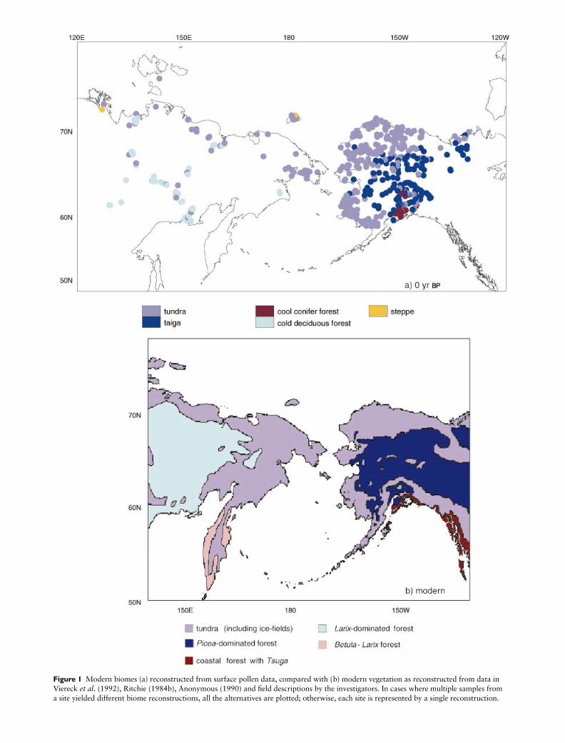
Figure 1 Modern biomes (a) reconstructed from surface pollen data, compared with (b) modern vegetation as reconstructed from data in Viereck et al. (1992), Ritchie (1984b), Anonymous (1990) and field descriptions by the investigators. In cases where multiple samples from a site yielded different biome reconstructions, all the alternatives are plotted; otherwise, each site is represented by a single reconstruction.
JBI426.fm Page 524 Wednesday, November 15, 2000 3:48 PM

Biome reconstructions for Beringia 525
© Blackwell Science Ltd 2000,
Journal of Biogeography, 27, 521–554
south-facing slopes (Yurtsev, 1982). Forests dominated byBetula ermani and Larix kurilensis cover much of Kamchatkaat low- and mid-elevations. The vegetation of the northern partof Sakhalin Island is predominantly mixed forest of Piceajezoensis and Abies sachalinensi. On the mainland coast tothe east, the upland forest of the lower Amur region is a mixof Abies nephrolepsis, Picea ajanensis and broadleaved trees.
Palaeoecological records
Palaeoenvironmental records from Beringia cover the lastglacial maximum, the subsequent deglaciation, and theHolocene. In eastern Beringia there is a relatively goodcoverage of modern and fossil pollen sites (see reviews inAger, 1983; Ritchie, 1984a, 1987; Ager & Brubaker, 1985;Barnosky et al., 1987; Lamb & Edwards, 1988; Anderson &Brubaker, 1993, 1994; Edwards & Barker, 1994). WesternBeringa is less extensively covered, but recent work (e.g.Lozhkin et al., 1993; Anderson & Lozhkin, 1995; Lozhkin& Anderson, 1995) has added considerably to the vegeta-tion records of this region.
DATA AND METHODS
Modern pollen and vegetation data
We assembled the raw pollen counts from 445 modern pollensamples from 411 sites in eastern Beringia (Table 1). Mostsamples (90%) were derived from surficial lake sediments orlacustrine sediment core tops; the rest were from peat, mosspolsters or alluvium. For western Beringia (Table 2) we obtaineda total of 238 samples from 92 different localities; 55 samplesare from unpublished original pollen counts, the others aredigitized from percentage data published in the literature.Most of the western Beringian samples were from mosspolsters, peat, alluvium or soil; the others (17%) weresurficial lake sediments. In Russia, the nature of the pollensum varies among authors (e.g. arboreal sum, non-arborealsum, sum of pollen and spores). We only used data fromthose publications in which the nature of the pollen sum wasdescribed, so it was possible to back-calculate pollen countsusing an arbitrary sum.
A map of modern vegetation (Fig. 1b) was made using themaps and descriptions in Viereck et al. (1992), Ritchie (1984b),Anonymous (1990) and from the personal knowledge of theinvestigators.
Pollen data for 6000 and 18,000 14C yr BP
The fossil pollen data were derived from both published andunpublished sources. Most of the data were obtained as rawcounts via the North American Pollen Database (NAPD) andthe PALE Pollen Database (PPD). Some published pollen dia-grams were digitized and are represented by percentage dataonly. Most of the records come from lake-sediment sections,the rest from peat sections or other deposits. For 6000 14Cyr bp we used 92 pollen spectra from 79 sites in easternBeringia (Table 3) and 24 spectra from 22 sites in western
Beringia (Table 4). Data for 18,000 14C yr bp were availablefor 11 dated Beringian sites, 3 of which are from westernBeringia (see Tables 3 and 4).
For each site, we used the pollen spectrum nearest to 6000or 18,000 14C yr bp, within a ± 500-year window. In onewestern Beringian site (Elikchan: Lozhkin & Anderson, 1995),a sample just outside the 6000 ± 500 yr bp time windowwas selected because the site was considered too importantgeographically to omit. All sites are radiocarbon-dated, andvirtually all the samples were defined by interpolation froman age model (in a few cases the sample was derived by a shortextrapolation). In cases when multiple age models wouldhave resulted in the selection of different samples, we biomisedall the samples. This exercise showed that the choice of differ-ent age models had no effect on the reconstructed biome,except in a very few cases. In cases where the choice of agemodel resulted in the reconstruction of different biomes, all ofthe alternative reconstructions are plotted on the final maps.
Biomization procedure
The biomization procedure has been described in detail byPrentice et al. (1996). Pollen taxa are assigned to one or moreplant functional types (PFTs), according to the structural andfunctional features of the constituent species, e.g. stature,phenology, leaf type, and bioclimatic tolerances. Each biomeis defined by a set of characteristic PFTs that is based on bothbioclimatic considerations and observed ranges of the PFTs.Combining the taxa to PFT, and the PFT to biome, alloca-tions allows a biome-taxon matrix to be constructed. Usinga fuzzy logic approach, each individual pollen spectrum isassumed to have a degree of affinity with each biome, whichcan be expressed numerically. The biome with the highestaffinity score is then selected as the one corresponding to thepollen spectrum. In cases where the highest affinity score fortwo or more biomes is equal, a tie-breaking rule is applied todetermine which biome is attributed to the sample, followingPrentice et al. (1996).
Following Tarasov et al. (1998), we included all terrestrialpollen taxa, except those that are obvious exotics to theregion and a few minor taxa with obscure biologies. Themotivation for doing this is that treeless biomes such as tundramay be better identified palynologically if a suite of minortaxa are included; otherwise relatively high levels of pollenof forest taxa may distort the tundra signal and resultantassignments in the biomization procedure. Spores of the lowervascular plants and mosses were excluded because their abund-ances can fluctuate dramatically as a result of changing sedi-ment influx due to changes in subaerial erosion even whentheir representation in the catchment vegetation is unchanged.Aquatic taxa were also excluded as they do not reflect ter-restrial vegetation. The cold deciduous forest of north-eastSiberia is dominated by Larix, which is very poorly repres-ented in both modern and fossil pollen assemblages; Larixmay not be represented in a modern pollen sample even whenlocally present. We applied a weighting ( × 20) to occurrencesof Larix in individual pollen spectra, in order to maximizethe chance of reconstructing cold deciduous forest when it
JBI426.fm Page 525 Wednesday, November 15, 2000 3:48 PM

526M
. E. Edwards et al.
© Blackw
ell Science Ltd 2000, Journal of Biogeography, 27, 521–554
Table 1 Characteristics of the surface pollen sample sites from Alaska and north-western Canada. Longitude is expressed by the standard convention, with + for °E and − for °W. For mapping purposes, some sites (indicated by ‡) which are very close to one another have been displaced slightly.
Site Site name Lat. (°N) Long. (°) Elev. (m) Sample type Modern vegetation type References
1 none 67.37 –147.70 n/a lake closed forest Anderson & Brubaker, unpublished2 none 67.55 –145.90 n/a lake mix of forest & tundra Anderson & Brubaker, unpublished3 none 68.33 –146.43 n/a lake tundra Anderson & Brubaker, unpublished4 none 68.33 –146.42 n/a lake tundra Anderson & Brubaker, unpublished5 none 68.40 –145.80 n/a lake closed forest Anderson & Brubaker, unpublished6 none 68.25 –145.20 n/a lake closed forest Anderson & Brubaker, unpublished7 none 67.27 –144.83 n/a lake open forest Anderson & Brubaker, unpublished8 none 68.38 –143.92 n/a lake closed forest Anderson & Brubaker, unpublished9 none 68.02 –143.05 n/a lake closed forest Anderson & Brubaker, unpublished10 none 67.30 –143.12 n/a lake open forest Anderson & Brubaker, unpublished11 none 67.08 –142.43 n/a lake closed forest Anderson & Brubaker, unpublished12 none 67.18 –142.07 n/a lake closed forest Anderson & Brubaker, unpublished13 none 67.18 –141.08 n/a lake closed forest Anderson & Brubaker, unpublished14 none‡ 66.83 –143.48 n/a lake closed forest Anderson & Brubaker, unpublished15 none‡ 66.83 –143.48 n/a lake open forest Anderson & Brubaker, unpublished16 none 66.35 –143.53 n/a lake open forest Anderson & Brubaker, unpublished17 none 66.25 –143.75 n/a lake open forest Anderson & Brubaker, unpublished18 none 66.00 –142.97 n/a lake closed forest Anderson & Brubaker, unpublished19 none 65.38 –143.12 n/a lake closed forest Anderson & Brubaker, unpublished20 none 65.52 –144.53 n/a lake open forest Anderson & Brubaker, unpublished21 none 65.47 –144.48 n/a lake open forest Anderson & Brubaker, unpublished22 none 66.52 –145.05 n/a lake closed forest Anderson & Brubaker, unpublished23 none 66.10 –145.87 n/a lake closed forest Anderson & Brubaker, unpublished24 none 66.08 –146.93 n/a lake open forest Anderson & Brubaker, unpublished25 none 66.20 –147.48 n/a lake closed forest Anderson & Brubaker, unpublished26 none 66.63 –147.77 n/a lake open forest Anderson & Brubaker, unpublished27 none 67.17 –148.22 n/a lake closed forest Anderson & Brubaker, unpublished28 none 67.57 –147.45 n/a lake closed forest Anderson & Brubaker, unpublished29 none 68.07 –147.20 n/a lake mix of forest & tundra Anderson & Brubaker, unpublished30 none 67.92 –156.82 n/a lake tundra Anderson & Brubaker, unpublished31 none 67.85 –158.40 n/a lake tundra Anderson & Brubaker, unpublished32 none 67.93 –160.42 n/a lake tundra Anderson & Brubaker, unpublished33 none 67.90 –162.60 n/a lake mix of forest & tundra Anderson & Brubaker, unpublished34 none 67.08 –162.38 n/a lake closed forest Anderson & Brubaker, unpublished35 none 67.22 –163.70 n/a lake tundra Anderson & Brubaker, unpublished36 none 67.90 –164.73 n/a lake tundra Anderson & Brubaker, unpublished37 none 68.43 –166.25 n/a lake tundra Anderson & Brubaker, unpublished38 none 68.68 –164.27 n/a lake tundra Anderson & Brubaker, unpublished39 none 68.00 –164.27 n/a lake tundra Anderson & Brubaker, unpublished40 none 67.90 –164.00 n/a lake tundra Anderson & Brubaker, unpublished41 none 66.87 –161.38 n/a lake tundra Anderson & Brubaker, unpublished42 none 67.12 –160.82 n/a lake mix of forest & tundra Anderson & Brubaker, unpublished43 none 66.75 –159.35 n/a lake tundra Anderson & Brubaker, unpublished
JBI426.fm
Page 526 W
ednesday, Novem
ber 15, 2000 3:48 PM

Biome reconstructions for Beringia
527
© Blackw
ell Science Ltd 2000, Journal of Biogeography, 27, 521–554
44 none 66.80 –158.35 n/a lake mix of forest & tundra Anderson & Brubaker, unpublished45 none 67.22 –158.60 n/a lake mix of forest & tundra Anderson & Brubaker, unpublished46 none 67.05 –156.45 n/a lake closed forest Anderson & Brubaker, unpublished47 none 67.77 –157.23 n/a lake mix of forest & tundra Anderson & Brubaker, unpublished48 none 66.48 –155.85 n/a lake closed forest Anderson & Brubaker, unpublished49 none 65.67 –155.57 n/a lake closed forest Anderson & Brubaker, unpublished50 none 64.83 –154.57 n/a lake closed forest Anderson & Brubaker, unpublished51 none 65.58 –153.70 n/a lake closed forest Anderson & Brubaker, unpublished52 none 65.07 –153.12 n/a lake closed forest Anderson & Brubaker, unpublished53 none 65.12 –151.60 n/a lake closed forest Anderson & Brubaker, unpublished54 none 65.03 –150.38 n/a lake open forest Anderson & Brubaker, unpublished55 none 65.65 –150.15 n/a lake closed forest Anderson & Brubaker, unpublished56 none 66.05 –150.28 n/a lake open forest Anderson & Brubaker, unpublished57 none 66.12 –151.45 n/a lake mix of forest & tundra Anderson & Brubaker, unpublished58 none 66.13 –151.80 n/a lake closed forest Anderson & Brubaker, unpublished59 none 66.58 –151.67 n/a lake closed forest Anderson & Brubaker, unpublished60 none 66.42 –150.50 n/a lake mix of forest & tundra Anderson & Brubaker, unpublished61 none 69.37 –150.23 n/a lake tundra Anderson & Brubaker, unpublished62 none 69.73 –149.50 n/a lake tundra Anderson & Brubaker, unpublished63 none 70.33 –149.23 n/a lake tundra Anderson & Brubaker, unpublished64 none 70.40 –150.45 n/a lake tundra Anderson & Brubaker, unpublished65 none 69.98 –150.97 n/a lake tundra Anderson & Brubaker, unpublished66 none 69.92 –150.77 n/a lake tundra Anderson & Brubaker, unpublished67 none 69.55 –150.88 n/a lake tundra Anderson & Brubaker, unpublished68 none 69.23 –151.15 n/a lake tundra Anderson & Brubaker, unpublished69 none 68.92 –151.32 n/a lake tundra Anderson & Brubaker, unpublished70 none 68.15 –151.70 n/a lake tundra Anderson & Brubaker, unpublished71 none 67.78 –152.22 n/a lake mix of forest & tundra Anderson & Brubaker, unpublished72 none 67.40 –152.03 n/a lake closed forest Anderson & Brubaker, unpublished73 none 67.40 –149.78 n/a lake mix of forest & tundra Anderson & Brubaker, unpublished74 none 67.40 –149.78 n/a lake mix of forest & tundra Anderson & Brubaker, unpublished75 none 67.23 –152.58 n/a lake mix of forest & tundra Anderson & Brubaker, unpublished76 none 67.58 –151.42 n/a lake open forest Anderson & Brubaker, unpublished77 none 67.13 –153.88 n/a lake mix of forest & tundra Anderson & Brubaker, unpublished79 none 67.97 –155.03 n/a lake tundra Anderson & Brubaker, unpublished80 none 67.57 –151.38 n/a lake mix of forest & tundra Anderson & Brubaker, unpublished81 none 67.13 –153.65 n/a lake mix of forest & tundra Anderson & Brubaker, unpublished82 none 65.92 –151.47 n/a lake closed forest Anderson & Brubaker, unpublished83 none 66.07 –147.53 n/a lake closed forest Anderson & Brubaker, unpublished84 none 67.70 –154.55 n/a lake mix of forest & tundra Anderson & Brubaker, unpublished85 none 66.72 –153.50 n/a lake closed forest Anderson & Brubaker, unpublished87 none 66.05 –145.78 n/a lake closed forest Anderson & Brubaker, unpublished88 none 71.12 –156.52 n/a lake tundra Anderson & Brubaker, unpublished89 none 70.43 –157.40 n/a lake tundra Anderson & Brubaker, unpublished90 none 70.55 –153.77 n/a lake tundra Anderson & Brubaker, unpublished
Site Site name Lat. (°N) Long. (°) Elev. (m) Sample type Modern vegetation type References
Table 1 continued
JBI426.fm
Page 527 W
ednesday, Novem
ber 15, 2000 3:48 PM

528M
. E. Edwards et al.
© Blackw
ell Science Ltd 2000, Journal of Biogeography, 27, 521–554
91 none 70.15 –153.77 n/a lake tundra Anderson & Brubaker, unpublished92 none 70.70 –158.4 n/a lake tundra Anderson & Brubaker, unpublished93 none 71.23 –156.37 n/a lake tundra Anderson & Brubaker, unpublished94 none 68.60 –160.53 n/a lake tundra Anderson & Brubaker, unpublished95 none 70.93 –154.67 n/a lake tundra Anderson & Brubaker, unpublished96 none 69.48 –156.05 n/a lake tundra Anderson & Brubaker, unpublished97 none 71.13 –156.52 n/a lake tundra Anderson & Brubaker, unpublished98 none 68.12 –161.42 n/a lake tundra Anderson & Brubaker, unpublished99 none 67.10 –160.38 n/a lake mix of forest & tundra Anderson & Brubaker, unpublished100 none 66.58 –157.25 n/a lake mix of forest & tundra Anderson & Brubaker, unpublished101 none 69.58 –153.25 n/a lake shrub tundra Anderson & Brubaker, unpublished102 none 67.43 –147.85 n/a lake forest tundra Anderson & Brubaker, unpublished103 none 66.80 –150.35 n/a lake forest tundra Anderson & Brubaker, unpublished104 none 68.13 –156.03 n/a lake shrub tundra Anderson & Brubaker, unpublished105 none 66.83 –155.73 n/a lake spruce forest Anderson & Brubaker, unpublished106 none 66.86 –155.71 n/a lake spruce forest Anderson & Brubaker, unpublished107 none 66.91 –155.03 n/a lake spruce forest Anderson & Brubaker, unpublished108 none 66.96 –156.45 n/a lake spruce forest Anderson & Brubaker, unpublished109 none 68.41 –149.92 n/a lake shrub tundra Anderson & Brubaker, unpublished110 none 65.94 –166.47 n/a lake low shrub/tussock tundra Anderson & Brubaker, unpublished111 none 66.09 –166.28 n/a lake low shrub/tussock tundra Anderson & Brubaker, unpublished112 none 66.36 –165.50 n/a lake tussock/grass tundra Anderson & Brubaker, unpublished113 none 66.13 –164.41 n/a lake shrub/tussock tundra Anderson & Brubaker, unpublished114 none 66.55 –164.27 n/a lake sedge/tussock tundra Anderson & Brubaker, unpublished115 none 66.52 –163.95 n/a lake tussock tundra Anderson & Brubaker, unpublished116 none 66.33 –159.13 n/a lake tall shrub/sedge tundra with open forest Anderson & Brubaker, unpublished117 none 64.60 –157.93 n/a lake shrub and open forest Anderson & Brubaker, unpublished118 none 64.92 –156.84 n/a lake shrub/tussock tundra Anderson & Brubaker, unpublished119 none 65.28 –156.91 n/a lake open forest Anderson & Brubaker, unpublished120 none 65.64 –157.16 n/a lake open forest Anderson & Brubaker, unpublished121 none 65.58 –163.90 n/a lake tussock tundra Anderson & Brubaker, unpublished122 none 66.19 –161.17 n/a lake shrub/tussock tundra Anderson & Brubaker, unpublished123 none 66.40 –161.79 n/a lake shrub/tussock tundra Anderson & Brubaker, unpublished124 none 67.74 –156.19 n/a lake tundra Anderson & Brubaker, unpublished125 none 68.33 –158.72 n/a lake tundra Anderson & Brubaker, unpublished126 none 68.25 –159.86 n/a lake shrub tundra Anderson & Brubaker, unpublished127 none 67.66 –162.55 n/a lake forest tundra Anderson & Brubaker, unpublished128 none 67.38 –162.82 n/a lake forest tundra Anderson & Brubaker, unpublished129 none 67.64 –164.07 n/a lake shrub tundra Anderson & Brubaker, unpublished130 none 64.43 –146.85 n/a lake boreal forest Anderson & Brubaker, unpublished131 none 64.31 –146.67 n/a lake boreal forest Anderson & Brubaker, unpublished132 none 64.21 –145.82 n/a lake boreal forest Anderson & Brubaker, unpublished133 none 64.09 –145.60 n/a lake black spruce muskeg, shrub/sedge Anderson & Brubaker, unpublished134 none 63.19 –145.65 n/a lake mix of forest & tundra Anderson & Brubaker, unpublished135 none 63.12 –145.50 n/a lake high shrub tundra Anderson & Brubaker, unpublished
Site Site name Lat. (°N) Long. (°) Elev. (m) Sample type Modern vegetation type References
Table 1 continued
JBI426.fm
Page 528 W
ednesday, Novem
ber 15, 2000 3:48 PM

Biome reconstructions for Beringia
529
© Blackw
ell Science Ltd 2000, Journal of Biogeography, 27, 521–554
136 none 63.05 –145.94 n/a lake high shrub tundra Anderson & Brubaker, unpublished137 none 62.95 –145.51 n/a lake boreal forest Anderson & Brubaker, unpublished138 none 62.71 –144.19 n/a lake boreal forest Anderson & Brubaker, unpublished139 none 62.91 –143.80 n/a lake boreal forest Anderson & Brubaker, unpublished140 none 63.23 –142.29 n/a lake boreal forest Anderson & Brubaker, unpublished141 none 62.98 –141.64 n/a lake boreal forest Anderson & Brubaker, unpublished142 none 62.89 –141.55 n/a lake boreal forest Anderson & Brubaker, unpublished143 none 62.65 –141.07 n/a lake black spruce muskeg-sedge meadows Anderson & Brubaker, unpublished144 none 63.36 –143.54 n/a lake black spruce muskeg Anderson & Brubaker, unpublished145 none 63.74 –144.71 n/a lake boreal forest Anderson & Brubaker, unpublished147 none 69.46 –143.74 n/a lake shrub tundra Anderson & Brubaker, unpublished148 none 69.41 –144.05 n/a lake shrub tundra Anderson & Brubaker, unpublished149 none 69.44 –144.03 n/a lake shrub tundra Anderson & Brubaker, unpublished151 none 63.92 –151.58 n/a lake boreal forest Anderson & Brubaker, unpublished152 none 67.00 –155.28 n/a lake spruce muskeg Anderson & Brubaker, unpublished153 none 66.38 –165.75 n/a lake spruce muskeg Anderson & Brubaker, unpublished154 none 63.02 –154.62 n/a lake boreal forest Anderson & Brubaker, unpublished155 none 61.63 –156.83 n/a lake boreal forest Anderson & Brubaker, unpublished156 none 61.56 –155.65 n/a lake boreal forest-lichen woodland Anderson & Brubaker, unpublished157 none 61.24 –155.74 n/a lake boreal forest-muskeg Anderson & Brubaker, unpublished158 none 60.64 –154.29 n/a lake boreal forest (near treeline) Anderson & Brubaker, unpublished159 none 60.16 –155.05 n/a lake boreal forest-lichen woodland Anderson & Brubaker, unpublished160 none 60.05 –156.28 n/a lake boreal forest Anderson & Brubaker, unpublished161 none 59.38 –156.89 n/a lake shrub tundra (some trees) Anderson & Brubaker, unpublished162 none 59.18 –156.03 n/a lake shrub tundra Anderson & Brubaker, unpublished163 none 58.77 –155.95 n/a lake shrub tundra Anderson & Brubaker, unpublished164 none 58.81 –156.73 n/a lake shrub tundra Anderson & Brubaker, unpublished165 none 58.74 –157.78 n/a lake shrub tundra (few trees) Anderson & Brubaker, unpublished166 none 58.79 –159.15 n/a lake shrub tundra (few trees) Anderson & Brubaker, unpublished167 none 59.53 –158.27 n/a lake open boreal forest Anderson & Brubaker, unpublished168 none 59.80 –158.52 n/a lake open boreal forest Anderson & Brubaker, unpublished169 none 59.57 –159.37 n/a lake lichen woodland Anderson & Brubaker, unpublished170 none 59.13 –160.08 n/a lake shrub tundra Anderson & Brubaker, unpublished171 none 59.43 –160.58 n/a lake shrub tundra Anderson & Brubaker, unpublished172 none 59.75 –161.78 n/a lake shrub tundra Anderson & Brubaker, unpublished173 none 60.03 –161.90 n/a lake shrub tundra Anderson & Brubaker, unpublished174 none 60.12 –163.08 n/a lake shrub/tussock tundra Anderson & Brubaker, unpublished175 none 60.33 –164.07 n/a lake wet tussock tundra Anderson & Brubaker, unpublished176 none 60.58 –162.63 n/a lake wet tundra/grassy Anderson & Brubaker, unpublished177 none 60.46 –161.77 n/a lake wet tundra/grassy Anderson & Brubaker, unpublished178 none 61.08 –161.68 n/a lake tussock tundra Anderson & Brubaker, unpublished179 none 60.98 –162.93 n/a lake shrub/tussock tundra Anderson & Brubaker, unpublished180 none 60.93 –164.33 n/a lake tussock tundra Anderson & Brubaker, unpublished181 none 61.43 –164.20 n/a lake tussock tundra Anderson & Brubaker, unpublished182 none 61.53 –165.10 n/a lake wet tussock tundra Anderson & Brubaker, unpublished
Site Site name Lat. (°N) Long. (°) Elev. (m) Sample type Modern vegetation type References
Table 1 continued
JBI426.fm
Page 529 W
ednesday, Novem
ber 15, 2000 3:48 PM

530M
. E. Edwards et al.
© Blackw
ell Science Ltd 2000, Journal of Biogeography, 27, 521–554
183 none 62.08 –165.53 n/a lake tussock tundra Anderson & Brubaker, unpublished184 none 62.10 –164.63 n/a lake tussock tundra Anderson & Brubaker, unpublished185 none 62.55 –164.50 n/a lake shrub/tussock tundra Anderson & Brubaker, unpublished186 none 62.37 –163.60 n/a lake shrub tundra/alder Anderson & Brubaker, unpublished187 none 62.02 –163.62 n/a lake shrub tundra Anderson & Brubaker, unpublished188 none 62.38 –162.17 n/a lake tussock tundra (few trees) Anderson & Brubaker, unpublished189 none 62.17 –161.67 n/a lake boreal forest transition Anderson & Brubaker, unpublished190 none 62.49 –159.55 n/a lake mix of forest & tundra Anderson & Brubaker, unpublished191 none 62.94 –159.57 n/a lake boreal forest-muskeg Anderson & Brubaker, unpublished192 none 63.05 –158.08 n/a lake mix of forest & tundra Anderson & Brubaker, unpublished193 none 63.52 –157.92 n/a lake boreal forest-muskeg Anderson & Brubaker, unpublished194 none 63.51 –159.38 n/a lake boreal forest Anderson & Brubaker, unpublished195 none 63.91 –158.85 n/a lake boreal forest-muskeg Anderson & Brubaker, unpublished196 none 63.85 –149.03 n/a lake forest-tundra Anderson & Brubaker, unpublished197 none 63.72 –148.85 n/a lake forest-tundra Anderson & Brubaker, unpublished198 none 63.38 –148.67 n/a lake spruce forest Anderson & Brubaker, unpublished199 none 63.29 –147.90 n/a lake boreal forest-tundra Anderson & Brubaker, unpublished200 none 63.20 –147.65 n/a lake boreal forest-tundra Anderson & Brubaker, unpublished201 none 63.35 –149.10 n/a lake boreal forest Anderson & Brubaker, unpublished202 none 62.73 –150.12 n/a lake spruce-hardwood deciduous forest Anderson & Brubaker, unpublished203 none 61.80 –148.20 n/a lake mix of forest & tundra Anderson & Brubaker, unpublished204 none 61.95 –147.17 n/a lake mix of forest & tundra Anderson & Brubaker, unpublished205 none 62.03 –146.65 n/a lake black spruce muskeg Anderson & Brubaker, unpublished206 none 62.10 –146.30 n/a lake black spruce muskeg Anderson & Brubaker, unpublished207 none 61.08 –146.15 n/a lake coastal forest Anderson & Brubaker, unpublished208 none 61.12 –145.73 n/a lake shrub tundra Anderson & Brubaker, unpublished209 none 61.72 –145.20 n/a lake boreal forest Anderson & Brubaker, unpublished210 none 62.10 –146.02 n/a lake black spruce muskeg Anderson & Brubaker, unpublished211 none 61.80 –148.20 n/a lake hardwood deciduous forest Anderson & Brubaker, unpublished212 none 64.33 –151.27 n/a lake black spruce muskeg Anderson & Brubaker, unpublished213 none 63.90 –151.50 n/a lake spruce-hardwood deciduous forest Anderson & Brubaker, unpublished214 none 63.54 –152.52 n/a lake black spruce muskeg Anderson & Brubaker, unpublished215 none 63.25 –153.56 n/a lake black spruce muskeg Anderson & Brubaker, unpublished220 none 68.48 –154.06 n/a lake low shrub tundra/alder Anderson & Brubaker, unpublished221 none 68.36 –154.64 n/a lake low shrub tundra Anderson & Brubaker, unpublished222 none 68.66 –155.86 n/a lake low shrub tundra Anderson & Brubaker, unpublished223 none 68.75 –156.42 n/a lake low shrub/tussock tundra Anderson & Brubaker, unpublished226 none 68.14 –158.13 n/a lake sedge/tussock tundra Anderson & Brubaker, unpublished227 none 69.70 –155.05 n/a lake sedge/tussock tundra Anderson & Brubaker, unpublished230 none 70.70 –156.27 n/a lake sedge/grass tundra Anderson & Brubaker, unpublished231 none 71.04 –154.98 n/a lake sedge/grass tundra Anderson & Brubaker, unpublished233 none 70.83 –157.41 n/a lake sedge/grass tundra Anderson & Brubaker, unpublished234 none 70.69 –158.49 n/a lake sedge/grass tundra Anderson & Brubaker, unpublished235 none 70.58 –159.55 n/a lake sedge/grass tundra Anderson & Brubaker, unpublished236 none 70.26 –158.43 n/a lake sedge/grass tundra Anderson & Brubaker, unpublished
Site Site name Lat. (°N) Long. (°) Elev. (m) Sample type Modern vegetation type References
Table 1 continued
JBI426.fm
Page 530 W
ednesday, Novem
ber 15, 2000 3:48 PM

Biome reconstructions for Beringia
531
© Blackw
ell Science Ltd 2000, Journal of Biogeography, 27, 521–554
238 none 70.11 –161.80 n/a lake sedge/tussock tundra Anderson & Brubaker, unpublished239 none 69.88 –161.27 n/a lake sedge/tussock tundra Anderson & Brubaker, unpublished240 none 69.81 –162.72 n/a lake sedge/grass tundra Anderson & Brubaker, unpublished241 none 69.48 –162.96 n/a lake sedge/grass tundra Anderson & Brubaker, unpublished242 none 69.62 –162.03 n/a lake sedge/grass tundra Anderson & Brubaker, unpublished243 none 69.56 –160.91 n/a lake sedge/tussock tundra Anderson & Brubaker, unpublished244 none 69.74 –156.11 n/a lake sedge/tussock tundra Anderson & Brubaker, unpublished248 none 69.31 –153.45 n/a lake low shrub tundra/alder Anderson & Brubaker, unpublished250 none 68.66 –148.52 n/a lake low shrub tundra Anderson & Brubaker, unpublished251 none 68.82 –149.06 n/a lake low shrub tundra Anderson & Brubaker, unpublished252 none 69.24 –148.95 n/a lake low shrub tussock tundra Anderson & Brubaker, unpublished254 none 70.02 –149.26 n/a lake sedge patterned ground Anderson & Brubaker, unpublished255 none 70.08 –147.40 n/a lake sedge patterned ground Anderson & Brubaker, unpublished256 none 70.09 –145.77 n/a lake sedge/grass patterned ground Anderson & Brubaker, unpublished257 none 70.06 –143.75 n/a lake sedge/grass tundra Anderson & Brubaker, unpublished258 none 69.86 –143.55 n/a lake sedge/tussock tundra Anderson & Brubaker, unpublished259 none 69.84 –146.61 n/a lake sedge/tussock tundra Anderson & Brubaker, unpublished260 none 69.97 –147.59 n/a lake sedge/tussock tundra Anderson & Brubaker, unpublished261 none 69.55 –150.33 n/a lake shrub/tussock tundra Anderson & Brubaker, unpublished262 none 69.60 –151.16 n/a lake shrub/sedge tussock tundra Anderson & Brubaker, unpublished263 none 69.92 –151.89 n/a lake sedge/shrub tussock tundra Anderson & Brubaker, unpublished264 none 69.58 –153.26 n/a lake shrub/sedge tussock tundra Anderson & Brubaker, unpublished265 none 69.23 –152.27 n/a lake shrub/sedge tundra Anderson & Brubaker, unpublished266 none 70.44 –149.11 n/a lake grass/sedge tundra Anderson & Brubaker, unpublished267 none 70.30 –150.51 n/a lake sedge/grass tundra Anderson & Brubaker, unpublished269 none 70.51 –153.00 n/a lake sedge/grass tundra Anderson & Brubaker, unpublished270 none 70.87 –153.72 n/a lake sedge/grass tundra Anderson & Brubaker, unpublished271 none 70.29 –153.87 n/a lake grass/sedge tundra Anderson & Brubaker, unpublished272 none 68.80 –150.79 n/a lake shrub/tussock tundra Anderson & Brubaker, unpublished273 none 68.91 –151.32 n/a lake shrub/tussock tundra Anderson & Brubaker, unpublished274 none 68.36 –151.71 n/a lake shrub/tussock tundra Anderson & Brubaker, unpublished277 none 63.71 –144.65 n/a lake closed boreal forest Anderson & Brubaker, unpublished278 none 63.57 –143.93 n/a lake closed boreal forest Anderson & Brubaker, unpublished279 Karoleva 67.39 –149.44 n/a lake alpine open forest/tundra transition Edwards & Krumhardt, unpublished280 Grayling 66.58 –150.23 n/a lake alpine open forest/tundra transition Edwards & Krumhardt, unpublished281 Frightened Duck 63.19 –149.10 n/a lake alpine open forest/tundra transition Edwards & Krumhardt, unpublished282 Pagan’s Puddle 68.48 –148.50 n/a lake arctic tundra Edwards & Krumhardt, unpublished283 Bog Walk 69.35 –148.38 n/a lake arctic tundra Edwards & Krumhardt, unpublished284 East Cobb 62.42 –144.02 n/a lake boreal forest Edwards & Krumhardt, unpublished285 Kent 68.40 –149.15 n/a lake arctic tundra Edwards & Krumhardt, unpublished286 Big Sky 69.35 –148.38 n/a lake arctic tundra Edwards & Krumhardt, unpublished287 Ozera 67.40 –149.43 n/a lake alpine open forest/tundra transition Edwards & Krumhardt, unpublished288 Stinky‡ 63.13 –147.41 n/a lake alpine tundra Edwards & Krumhardt, unpublished289 Downwind 63.04 –146.12 n/a lake alpine tundra Edwards & Krumhardt, unpublished290 Parallel Pipeline 67.08 –150.21 n/a lake alpine open forest/tundra transition Edwards & Krumhardt, unpublished
Site Site name Lat. (°N) Long. (°) Elev. (m) Sample type Modern vegetation type References
Table 1 continued
JBI426.fm
Page 531 W
ednesday, Novem
ber 15, 2000 3:48 PM

532M
. E. Edwards et al.
© Blackw
ell Science Ltd 2000, Journal of Biogeography, 27, 521–554
291 Lost Quartz 64.12 –145.50 n/a lake boreal forest Edwards & Krumhardt, unpublished292 Yarger 62.58 –141.38 n/a lake boreal forest Edwards & Krumhardt, unpublished293 Tern 63.24 –148.40 n/a lake alpine open forest/tundra transition Edwards & Krumhardt, unpublished294 Smith 64.52 –147.52 n/a lake boreal forest Edwards & Krumhardt, unpublished295 Windmill 63.39 –148.49 n/a lake alpine open forest/tundra transition Edwards & Krumhardt, unpublished296 Swampbuggy 63.03 –147.25 n/a lake alpine open forest/tundra transition Edwards & Krumhardt, unpublished297 Marina 63.46 –145.48 n/a lake alpine open forest/tundra transition Edwards & Krumhardt, unpublished298 Stormy Bathtub 68.27 –149.22 n/a lake arctic tundra Edwards & Krumhardt, unpublished299 Little Harding 64.25 –146.54 n/a lake boreal forest Edwards & Krumhardt, unpublished300 Float Plane 63.24 –148.40 n/a lake alpine open forest/tundra transition Edwards & Krumhardt, unpublished301 Bonanza Creek Lake 64.45 –148.18 n/a lake boreal forest Edwards & Krumhardt, unpublished302 10 Mile 63.05 –145.42 n/a lake alpine tundra Edwards & Krumhardt, unpublished303 Ace 64.52 –147.56 n/a lake boreal forest Edwards & Krumhardt, unpublished304 Last Tundra 68.28 –149.23 n/a lake arctic tundra Edwards & Krumhardt, unpublished305 Dune 64.25 –149.54 n/a lake boreal forest Edwards & Krumhardt, unpublished306 Nutella‡ 63.13 –147.41 n/a lake alpine tundra Edwards & Krumhardt, unpublished307 Quartz 64.12 –145.50 n/a lake boreal forest Edwards & Krumhardt, unpublished308 Lost Birch 64.18 –146.41 n/a lake boreal forest Edwards & Krumhardt, unpublished309 Jaeger 68.39 –149.28 n/a lake arctic tundra Edwards & Krumhardt, unpublished310 Birch 64.18 –146.38 n/a lake boreal forest Edwards & Krumhardt, unpublished311 Jan 63.34 –143.54 n/a lake boreal forest Edwards & Krumhardt, unpublished312 Meli 68.41 –149.05 n/a lake arctic tundra Edwards & Krumhardt, unpublished313 Harding 64.25 –146.54 n/a lake boreal forest Edwards & Krumhardt, unpublished314 Toolik, Site 1 68.38 –149.36 n/a lake arctic tundra Edwards & Krumhardt, unpublished315 Round Tangle 63.03 –146.00 n/a lake alpine tundra Edwards & Krumhardt, unpublished316 Paxson 62.56 –145.31 n/a lake boreal forest Edwards & Krumhardt, unpublished317 Robe Lake 61.09 –146.17 12 lake Pacific coastal forest Ager, unpublished318 Sagwon Bluffs,
N slope (R3310)69.25 –148.67 < 1000 peat arctic mesic tundra Ager, unpublished
319 Summit Lake‡ 61.77 –149.32 1158 lake alpine tundra Ager, unpublished320 Stop 2, N slope (R3309) 69.25 –148.67 < 1000 peat arctic tundra Ager, unpublished321 Worthington Glacier 61.17 –145.71 661 lake alpine tundra with alder/willow shrubs Ager, unpublished322 Pond #2,
Worthington Glacier61.17 –145.71 661 lake alpine tundra with alder/willow shrubs Ager, unpublished
323 Kepler Lake, Palmer 61.55 –149.21 27 lake boreal forest Ager, unpublished324 Robe Lake, Valdez 61.09 –146.17 12 lake Pacific coastal forest Ager, unpublished325 Summit L./Hatcher Pass‡ 61.77 –149.32 1149 lake alpine tundra Ager, unpublished326 Willow Creek 61.77 –149.71 454 lake boreal forest Ager, unpublished327 S. Rolly Lake 61.67 –150.13 58 lake boreal forest Ager, unpublished328 Toklat River Lake (R2151) 63.50 –150.33 n/a lake boreal forest Ager, unpublished329 Austin’s Cabin,
St. Michael Village63.47 –162.09 9 surface sample peat bog Ager, unpublished
330 St. Michael Village 63.48 –162.10 9 shallow pond mesic coastal tundra Ager, unpublished331 St. Michael Village 63.47 –162.07 9 shallow pond mesic coastal tundra Ager, unpublished
Site Site name Lat. (°N) Long. (°) Elev. (m) Sample type Modern vegetation type References
Table 1 continued
JBI426.fm
Page 532 W
ednesday, Novem
ber 15, 2000 3:48 PM

Biome reconstructions for Beringia
533
© Blackw
ell Science Ltd 2000, Journal of Biogeography, 27, 521–554
333 St. Michael Village, peat section
63.48 –162.08 12 shallow pond mesic coastal tundra Ager, unpublished
334 Lucille Lake, Wasilla 61.58 –149.45 99 lake disturbed boreal forest Ager, unpublished335 Loon Lake 61.60 –149.75 76 lake boreal forest Ager, unpublished336 70 Mile Lake,
Richardson Hwy61.52 –145.23 564 lake boreal forest Ager, unpublished
337 Grouse Lake 60.20 –149.38 76 lake Pacific coastal forest Ager, unpublished338 Denali Hwy, mile 8 63.08 –145.65 1097 pond sediment shrub tundra with some spruce Ager, unpublished339 Denali Hwy, mile 15 63.05 –145.83 1036 pond sediment shrub tundra Ager, unpublished340 Theneta Lake (Leila Lake) 61.90 –147.31 893 lake boreal forest Ager, unpublished341 Richardson Hwy 61.86 –145.23 443 pond sediment boreal forest Ager, unpublished342 Copper River Basin 62.37 –145.15 552 peat boreal forest Ager, unpublished343 Long Lake 61.80 –148.22 453 lake boreal forest Ager, unpublished344 Kenny Lake 61.73 –144.94 383 lake boreal forest Ager, unpublished345 Silvertip Creek‡ 60.73 –149.30 198 moss polster boreal forest/Pacific coastal forest Ager, unpublished346 Sterling Hwy 60.78 –149.21 290 beaver pond boreal forest/Pacific coastal forest Ager, unpublished347 Beluga Lake 59.64 –151.53 3 lake salt marsh/Pacific coastal forest Ager, unpublished348 Crow Creek Mine 61.00 –148.08 244 moss polster Pacific coastal forest Ager, unpublished349 Christiansen Lake,
Talkeetna area62.32 –150.06 107 lake boreal forest Ager, unpublished
350 Longmere Lake‡ 60.51 –150.91 78 lake boreal forest Ager, unpublished351 Portage Lakes area 60.73 –150.55 76 moss, lake edge disturbed boreal forest Ager, unpublished352 Knik salt marsh 61.47 –149.73 3 shallow pond salt marsh nr boreal forest Ager, unpublished353 Parks Hwy 63.33 –149.17 869 peat + moss boreal forest Ager, unpublished354 Nancy Lakes 61.68 –150.08 59 lake boreal forest Ager, unpublished355 Wasilla Lake 61.58 –149.41 98 lake disturbed boreal forest Ager, unpublished356 Little Susitna River 61.76 –149.23 457 surface mud boreal forest Ager, unpublished357 Willow Creek 61.76 –149.57 549 shallow pond boreal forest Ager, unpublished358 Kepler Lake, Wasilla 61.55 –149.21 27 lake boreal forest Ager, unpublished359 Mile 99 Parks Hwy 62.14 –150.05 101 lake boreal forest Ager, unpublished360 Matanuska Lake 61.55 –149.23 24 lake boreal forest Ager, unpublished361 Junction Lake 61.56 –149.26 24 lake boreal forest Ager, unpublished362 Junction Lake 61.56 –149.26 24 lake disturbed boreal forest Ager, unpublished363 Echo Lake 61.55 –149.22 24 lake boreal forest Ager, unpublished364 Denali Hwy, M 95 63.26 –147.78 899 pond sediment tundra Ager, unpublished365 Winchester Lagoon 61.21 –149.90 2 shallow pond salt marsh nr boreal forest Ager, unpublished366 Christiansen Lake (R3096) 62.42 –150.67 < 1000 lake n/a Ager, unpublished367 Ptarmigan Pond,
St. Michael (R2101)63.50 –162.05 0 lake mesic coastal tundra Ager, unpublished
368 N. Yukon Delta, Jones’ site‡
63.17 –163.80 3 pond sediment mesic coastal tundra Ager, unpublished
369 Stebbins, St. Michael 63.53 –162.28 5 shallow pond mesic coastal tundra Ager, unpublished370 Pond, St. Marys (R1643) 62.08 –163.25 < 1000 lake boreal forest Ager, unpublished371 Yukon Delta 62.08 –164.93 9 shallow pond mesic to wet coastal tundra Ager, unpublished372 Yukon Delta 62.08 –164.93 9 shallow pond mesic to wet coastal tundra Ager, unpublished
Site Site name Lat. (°N) Long. (°) Elev. (m) Sample type Modern vegetation type References
Table 1 continued
JBI426.fm
Page 533 W
ednesday, Novem
ber 15, 2000 3:48 PM

534M
. E. Edwards et al.
© Blackw
ell Science Ltd 2000, Journal of Biogeography, 27, 521–554
373 Yukon Delta 62.73 –164.33 3 shallow pond mesic to wet coastal tundra Ager, unpublished374 NW Yukon Delta 62.53 –165.10 2 shallow pond mesic to wet coastal tundra Ager, unpublished375 Yukon Delta 62.95 –164.63 3 shallow pond mesic to wet coastal tundra Ager, unpublished376 Kgun Lake, Yukon Delta 61.58 –163.75 6 tundra pond shrub tundra Ager, unpublished377 Coastal station 24,
Yukon Delta62.00 –165.75 3 shallow pond mesic to wet coastal tundra Ager, unpublished
378 Scammon Bay 61.83 –165.58 3 shallow pond mesic to wet coastal tundra Ager, unpublished379 The Sisters volcanic flows 63.33 –161.68 305 shallow pond mesic tundra with local bog Ager, unpublished380 Yukon Delta 62.08 –164.93 9 shallow pond mesic to wet coastal tundra Ager, unpublished381 Yukon Delta (R1936) 62.08 –164.93 9 pond sediment n/a Ager, unpublished382 Yukon Delta (R1906) 62.08 –164.93 9 pond sediment n/a Ager, unpublished383 Yukon Delta 62.08 –164.93 9 pond sediment coastal tundra Ager, unpublished384 Tungak Lake area 61.17 –164.20 46 peat xeric tundra Ager, unpublished385 Tungak Lake 61.19 –164.17 46 peat shrub tundra Ager, unpublished386 Tungak Lake 61.19 –164.17 43 peat mesic to wet tundra Ager, unpublished387 Puyuk Lake,
St. Michael Island63.50 –162.21 12 lake mesic shrub tundra Ager, unpublished
388 Puyuk Lake area, St. Michael Island
63.50 –162.22 15 pond sediment mesic shrub tundra Ager, unpublished
389 Yukon Delta 62.63 –164.20 15 peat mesic to wet tundra Ager, unpublished390 Tungak Lake 61.19 –164.22 27 lake mesic tundra Ager, unpublished391 St. Michael Island 63.51 –162.10 15 surface mesic shrub tundra Ager, unpublished392 Yukon Delta 62.67 –164.86 2 pond sediment mesic to wet tundra Ager, unpublished393 Ingakslugwat Lake 61.18 –164.13 76 peat mesic tundra with shrubs Ager, unpublished394 Yukon Delta 62.37 –162.83 6 moss, pon, edge shrub mesic tundra Ager, unpublished395 Yukon Delta 62.80 –164.43 3 peat mesic tundra Ager, unpublished396 Point Romanof 63.19 –162.83 3 peat mesic tundra Ager, unpublished397 Longmere Lake‡ 60.51 –150.91 78 lake sediment boreal forest Ager, unpublished398 Yukon Delta (R1353) 62.38 –163.80 n/a n/a n/a Ager, unpublished399 Yukon Delta (R1352) 62.07 –163.53 n/a peat n/a Ager, unpublished403 Denali Hwy, 2 Mile
W of Cantwell (R1689)63.33 –148.92 < 1000 surface boreal forest Ager, unpublished
404 Drashner Lake, M 131, Denali Hwy (R1687)
63.00 –145.83 > 1000 surface mud boreal forest Ager, unpublished
406 Usibelli Mine, Nenana Valley (R1456)
63.83 –149.83 < 1000 lake boreal forest Ager, unpublished
407 Bison Gulch (R1450) 63.83 –149.00 < 1000 surface sample boreal forest Ager, unpublished408 Lake George 63.75 –144.75 < 1000 lake boreal forest Ager, unpublished409 Blair Lake (R1458) 64.50 –147.33 n/a lake boreal forest Ager, unpublished412 Bear Lake 60.42 –152.37 110 lake boreal forest/Pacific coastal forest Ager, unpublished413 Watana Triangle
Pond (R3365A)‡62.84 –148.24 n/a lake boreal forest/shrub tundra Ager, unpublished
414 Watana Triangle Pond (R3347)‡
62.84 –148.24 n/a lake boreal forest/shrub tundra Ager, unpublished
Site Site name Lat. (°N) Long. (°) Elev. (m) Sample type Modern vegetation type References
Table 1 continued
JBI426.fm
Page 534 W
ednesday, Novem
ber 15, 2000 3:48 PM

Biome reconstructions for Beringia
535
© Blackw
ell Science Ltd 2000, Journal of Biogeography, 27, 521–554
415 Watana Triangle Pond (R3348)
62.84 –148.24 n/a lake boreal forest/shrub tundra Ager, unpublished
416 Watana Triangle Pond (R3345)
62.84 –148.24 n/a lake boreal forest/shrub tundra Ager, unpublished
417 Watana Triangle Pond (R3346)
62.84 –148.24 n/a lake boreal forest/shrub tundra Ager, unpublished
418 Johnson R bog‡ 63.17 –163.80 440 peat boreal forest Ager, unpublished419 Tungak Lake (R1977) 61.17 –164.20 46 n/a n/a Ager, unpublished421 Silvertip Creek area‡ 60.73 –149.30 198 shallow pond open boreal forest/Pacific coastal forest Ager, unpublished422 Beaverpond 60.78 –149.21 290 pond sediment boreal forest/Pacific coastal forest Ager, unpublished423 Grouse Lake nr Seward 60.08 –149.50 76 lake Pacific coastal forest Ager, unpublished424 Longmere Lake 60.51 –150.91 78 lake boreal forest Ager, unpublished425 Yukon Delta 62.42 –165.25 2 shallow pond wet to mesic tundra Ager, unpublished426 Yukon Delta N
of Scammon Bay62.10 –165.42 3 shallow pond wet to mesic tundra Ager, unpublished
427 Delta, south end of Nelson Island
60.42 –165.13 2 shallow pond mesic to wet coastal tundra Ager, unpublished
428 Nelson Island, Lowland near Tununak
60.57 –165.25 8 shallow pond mesic to wet coastal tundra Ager, unpublished
429 Nelson Island, Lowlands 60.58 –165.27 9 shallow pond mesic shrub tundra Ager, unpublished430 Yukon Delta, W
of Newtok61.20 –164.75 6 shallow pond mesic shrub tundra Ager, unpublished
431 Yukon Delta, E of Newtok (R1227)
60.92 –164.50 n/a shallow pond mesic shrub tundra Ager, unpublished
432 Yukon Delta, NW Hooper Bay
61.53 –166.17 9 shallow pond mesic shrub tundra Ager, unpublished
433 Shaw Site, Yukon Delta (no code)
61.53 –166.17 n/a tundra pond mesic shrub tundra Ager, unpublished
434 Tungak Lake, Yukon Delta
61.18 –164.17 38 peat mesic shrub tundra Ager, unpublished
435 Tungak Lake, Yukon Delta
61.18 –164.17 61 surface mud mesic shrub tundra Ager, unpublished
436 Quartz Lake 64.25 –145.83 290 lake boreal forest Ager, unpublished437 NOATAK1 68.07 –159.26 230 moss polster tundra Elias et al., 1999438 NOATAK2 68.07 –159.26 230 moss polster tundra Elias et al., 1999439 NOATAK3 68.07 –159.26 230 moss polster tundra Elias et al., 1999440 NOATAK4 68.07 –159.26 230 moss polster tundra Elias et al., 1999441 NOATAK5 68.07 –159.26 230 moss polster tundra Elias et al., 1999442 NOATAK6 68.07 –159.26 230 moss polster tundra Elias et al., 1999443 NOATAK7 68.70 –159.26 230 moss polster tundra Elias et al., 1999444 NOATAK8 68.12 –159.77 200 moss polster tundra Elias et al., 1999445 NOATAK9 68.15 –160.36 160 moss polster tundra Elias et al., 1999446 NOATAK10 68.15 –160.36 160 moss polster tundra Elias et al., 1999447 NOATAK11 67.90 –160.87 140 moss polster tundra Elias et al., 1999448 NOATAK12 67.90 –160.87 140 moss polster tundra Elias et al., 1999
Site Site name Lat. (°N) Long. (°) Elev. (m) Sample type Modern vegetation type References
Table 1 continued
JBI426.fm
Page 535 W
ednesday, Novem
ber 15, 2000 3:48 PM

536M
. E. Edwards et al.
© Blackw
ell Science Ltd 2000, Journal of Biogeography, 27, 521–554
449 NOATAK13 67.90 –160.87 140 moss polster tundra Elias et al., 1999450 NOATAK14 67.90 –160.87 140 moss polster tundra Elias et al., 1999451 NOATAK15‡ 67.97 –161.925 85 moss polster gallery forest Elias et al., 1999452 NOATAK16‡ 67.97 –161.925 85 moss polster gallery forest Elias et al., 1999453 S72094A 64.90 –162.67 100 moss polster gallery forest Elias et al., 1999454 S72194B 64.75 –165.20 200 moss polster tundra Elias et al., 1999455 S72194D 64.90 –165.00 300 moss polster tundra Elias et al., 1999456 S5002 69.25 –133.67 30 lake tundra Anderson et al., 1989457 S5007 68.38 –138.38 500 lake tundra Anderson et al., 1989458 S5008 68.27 –133.47 75 lake forest/tundra Anderson et al., 1989459 S5010 65.95 –135.52 610 lake forest/tundra Anderson et al., 1989460 S5011 67.20 –130.77 300 lake forest/tundra Anderson et al., 1989461 S5014 68.30 –133.42 85 lake forest/tundra Anderson et al., 1989462 S5015 68.25 –131.07 210 lake forest/tundra Anderson et al., 1989463 S5020 67.68 –136.55 275 lake forest/tundra Anderson et al., 1989464 S5021 66.05 –135.63 760 lake forest/tundra Anderson et al., 1989465 S5022 69.05 –133.45 70 lake tundra Anderson et al., 1989466 S5023 67.65 –132.02 300 lake forest/tundra Anderson et al., 1989467 S5137 69.65 –131.50 30 lake tundra Anderson et al., 1989468 S5138 69.97 –130.47 20 lake tundra Anderson et al., 1989469 S5139 69.35 –131.70 25 lake tundra Anderson et al., 1989470 S5140 69.12 –133.18 30 lake tundra Anderson et al., 1989471 S5152 69.57 –134.38 20 lake tundra Anderson et al., 1989472 S5163 68.10 –132.75 260 lake forest/tundra Anderson et al., 1989473 S5167 68.40 –132.50 190 lake forest/tundra Anderson et al., 1989474 S5169 68.57 –131.00 170 lake forest/tundra Anderson et al., 1989475 S5160 68.88 –134.20 100 lake tundra Anderson et al., 1989
Site Site name Lat. (°N) Long. (°) Elev. (m) Sample type Modern vegetation type References
Table 1 continued
JBI426.fm
Page 536 W
ednesday, Novem
ber 15, 2000 3:48 PM

Biome reconstructions for Beringia 537
© Blackwell Science Ltd 2000, Journal of Biogeography, 27, 521–554
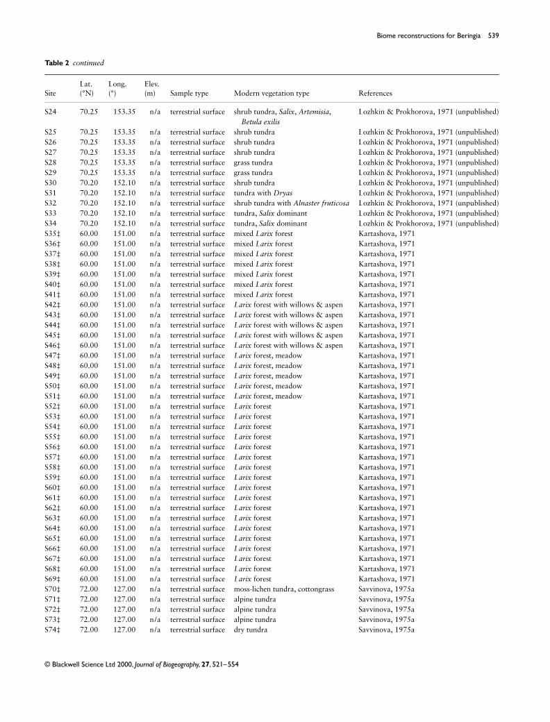
Table 2 Characteristics of the surface pollen samples sites from Siberia. Longitude is expressed by the standard convention, with + for °E and − for °W. For mapping purposes, some sites (indicated by ‡) which are very close to one another have been displaced slightly.
SiteLat. (°N)
Long. (°)
Elev. (m) Sample type Modern vegetation type References
R050‡ 70.75 136.27 10 terrestrial surface Larix forest Klimanov & Andreev, 1992R051‡ 70.75 136.27 10 terrestrial surface Larix forest Klimanov & Andreev, 1992R052‡ 70.75 136.27 10 terrestrial surface Larix forest Klimanov & Andreev, 1992R053‡ 70.75 136.27 10 terrestrial surface Larix forest Klimanov & Andreev, 1992R054‡ 70.75 136.27 10 terrestrial surface Larix forest Klimanov & Andreev, 1992R055‡ 70.75 136.27 10 terrestrial surface Larix forest Klimanov & Andreev, 1992R056 70.97 136.53 5 terrestrial surface Larix forest-tundra Klimanov & Andreev, 1992R057 70.84 136.53 5 terrestrial surface Larix forest-tundra Klimanov & Andreev, 1992R058‡ 71.15 136.00 5 terrestrial surface Larix forest-tundra Klimanov & Andreev, 1992R059‡ 71.15 136.00 5 terrestrial surface Larix forest-tundra Klimanov & Andreev, 1992R060‡ 71.15 136.00 5 terrestrial surface Larix forest-tundra Klimanov & Andreev, 1992R061‡ 71.15 136.00 5 terrestrial surface Larix forest-tundra Klimanov & Andreev, 1992R072 67.92 135.58 200 terrestrial surface Larix forest Evteeva, pers. comm.R073 66.75 136.50 250 terrestrial surface Larix forest Evteeva, pers. comm.R079 67.99 135.17 200 terrestrial surface Larix forest Evteeva, pers. comm.R081 67.72 135.58 200 terrestrial surface Larix forest Evteeva, pers. comm.R082 67.92 135.42 220 terrestrial surface Larix forest Evteeva, pers. comm.R083 66.50 136.50 250 terrestrial surface Larix forest Evteeva, pers. comm.R090 64.67 141.67 600 terrestrial surface Larix forest Evteeva, pers. comm.R101 62.67 147.50 500 terrestrial surface Larix forest Evteeva, pers. comm.R102‡ 60.17 151.33 1060 terrestrial surface Larix forest-tundra Vas’kovskiy, 1957R103‡ 60.17 151.33 1000 terrestrial surface Larix forest-tundra Vas’kovskiy, 1957R105 65.50 151.00 100 terrestrial surface Larix forest Vas’kovskiy, 1957R109 59.50 150.75 200 terrestrial surface Larix forest Vas’kovskiy, 1957R110 60.00 150.17 300 terrestrial surface Larix forest Vas’kovskiy, 1957R111 62.67 147.50 600 terrestrial surface Larix forest Evteeva, pers. comm.R112 60.00 150.17 300 terrestrial surface Larix forest Vas’kovskiy, 1957R117 62.67 147.50 500 terrestrial surface Larix forest Evteeva, pers. comm.R118 62.67 147.50 400 terrestrial surface Larix forest Evteeva, pers. comm.R119 69.50 173.00 70 terrestrial surface shrub tundra Vas’kovskiy, 1957R120 69.50 173.00 70 terrestrial surface shrub tundra Vas’kovskiy, 1957R121 69.75 173.33 50 terrestrial surface shrub tundra Vas’kovskiy, 1957R122 69.75 173.33 50 terrestrial surface shrub tundra Vas’kovskiy, 1957R123 66.00 180.00 100 terrestrial surface herb tundra Vas’kovskiy, 1957R124 66.00 180.00 100 terrestrial surface herb tundra Vas’kovskiy, 1957KHO-
CHO71.13 136.25 10 terrestrial surface Larix forest-tundra Andreev, unpublished
R42 71.17 –179.65 204 lake high arctic herb tundra Anderson & Lozhkin, unpublishedR43 71.17 –179.00 7 lake high arctic herb tundra Anderson & Lozhkin, unpublishedR44 71.17 –179.00 7 lake high arctic herb tundra Anderson & Lozhkin, unpublishedR45 71.17 –179.42 8 lake high arctic herb tundra Anderson & Lozhkin, unpublishedR46 71.17 –179.42 7 lake high arctic herb tundra Anderson & Lozhkin, unpublishedR47 71.17 –179.42 7 lake high arctic herb tundra Anderson & Lozhkin, unpublishedR48 71.17 –179.17 55 lake high arctic herb tundra Anderson & Lozhkin, unpublishedR49 71.20 –178.75 120 lake fellfield Anderson & Lozhkin, unpublishedR50 71.20 –178.70 215 lake fellfield Anderson & Lozhkin, unpublishedR51 67.75 –178.83 280 lake shrub tundra Anderson & Lozhkin, unpublishedR52 63.42 176.55 103 lake shrub tundra Anderson & Lozhkin, unpublishedR53 63.17 176.75 121 lake shrub tundra Anderson & Lozhkin, unpublishedR54 62.17 149.50 822 lake Larix forest Anderson & Lozhkin, unpublishedR55 62.17 149.50 870 lake Larix forest Anderson & Lozhkin, unpublished
JBI426.fm Page 537 Wednesday, November 15, 2000 3:48 PM

538 M. E. Edwards et al.
© Blackwell Science Ltd 2000, Journal of Biogeography, 27, 521–554
R56 62.08 149.00 1040 lake Larix forest-tundra Anderson & Lozhkin, unpublishedR57 62.10 149.00 1053 lake Larix forest-tundra Anderson & Lozhkin, unpublishedR58‡ 60.75 151.88 810 lake Larix forest Anderson & Lozhkin, unpublishedR59 59.85 150.62 115 lake Larix forest Anderson & Lozhkin, unpublishedR60 59.55 151.83 95 lake Larix forest Anderson & Lozhkin, unpublishedR61 59.75 149.92 3 lake Larix forest Anderson & Lozhkin, unpublishedR62 62.17 149.50 800 lake Larix forest Anderson & Lozhkin, unpublishedR63 62.17 149.50 870 lake Larix forest Anderson & Lozhkin, unpublishedR64‡ 60.75 151.88 810 lake Larix forest Anderson & Lozhkin, unpublishedR65 60.75 151.88 810 lake Larix forest Anderson & Lozhkin, unpublishedR66 60.75 151.88 810 lake Larix forest Anderson & Lozhkin, unpublishedR67 60.12 151.00 400 lake Larix forest Anderson & Lozhkin, unpublishedR68 60.32 151.15 850 lake Larix forest Anderson & Lozhkin, unpublishedR69 61.02 151.72 980 lake Larix forest Anderson & Lozhkin, unpublishedR70 61.17 152.08 870 lake Larix forest-tundra Anderson & Lozhkin, unpublishedR71 61.12 152.27 810 lake Larix forest Anderson & Lozhkin, unpublishedR72 61.13 152.33 750 lake Larix forest Anderson & Lozhkin, unpublishedR73 63.38 147.65 969 lake Larix forest Anderson & Lozhkin, unpublishedR74 63.32 147.63 850 lake Larix forest-tundra Anderson & Lozhkin, unpublishedR75 64.18 148.20 850 lake Larix forest-tundra Anderson & Lozhkin, unpublishedR76 64.30 144.93 700 lake Larix forest Anderson & Lozhkin, unpublishedR77 64.30 144.90 700 lake Larix forest Anderson & Lozhkin, unpublishedR78 64.50 143.78 550 lake Larix forest-tundra Anderson & Lozhkin, unpublishedR79 64.75 141.12 800 lake Larix forest Anderson & Lozhkin, unpublishedR80 64.22 145.16 800 lake Larix forest Anderson & Lozhkin, unpublishedR81 67.50 172.08 490 lake shrub tundra Anderson & Lozhkin, unpublishedR82 67.50 172.08 490 lake shrub tundra Anderson & Lozhkin, unpublishedR83 67.50 172.08 490 lake shrub tundra Anderson & Lozhkin, unpublishedS1 68.75 161.25 n/a terrestrial surface Sphagnum, sedges Vas’kovskiy, 1957S2‡ 65.70 150.82 n/a terrestrial surface Sphagnum, sedges Vas’kovskiy, 1957S3 64.75 141.56 n/a terrestrial surface steppe Vas’kovskiy, 1957S4 67.67 134.53 n/a terrestrial surface steppe Vas’kovskiy, 1957S5‡ 62.67 147.75 n/a terrestrial surface steppe Vas’kovskiy, 1957S6‡ 62.67 147.75 n/a terrestrial surface steppe Vas’kovskiy, 1957S7 69.75 170.31 n/a terrestrial surface moss-lichen tundra Vas’kovskiy, 1957S8 69.75 170.31 n/a terrestrial surface shrub tundra Vas’kovskiy, 1957S9 66.26 179.16 n/a terrestrial surface dry tundra Vas’kovskiy, 1957S10 66.26 179.16 n/a terrestrial surface boggy tundra Vas’kovskiy, 1957S11 67.67 134.53 n/a terrestrial surface Pinus pumula dominant Vas’kovskiy, 1957S13‡ 64.75 141.00 n/a terrestrial surface Pinus pumula dominant Vas’kovskiy, 1957S14 64.58 143.23 n/a terrestrial surface Pinus pumula dominant Vas’kovskiy, 1957S15‡ 65.70 150.82 n/a terrestrial surface Larix forest Vas’kovskiy, 1957S16 68.75 161.25 n/a terrestrial surface Larix forest Vas’kovskiy, 1957S17‡ 64.75 141.00 n/a terrestrial surface sedges, grass Vas’kovskiy, 1957S18 64.75 141.00 n/a terrestrial surface grass Vas’kovskiy, 1957S19 70.00 153.40 n/a terrestrial surface tundra with Salix, cottongrass Lozhkin & Prokhorova, 1971 (unpublished)S20 70.00 153.40 n/a terrestrial surface tundra with Carex communities Lozhkin & Prokhorova, 1971 (unpublished)S21 70.00 153.40 n/a terrestrial surface boggy tundra with Salix Lozhkin & Prokhorova, 1971 (unpublished)S22 70.00 153.40 n/a terrestrial surface shrub tundra, Betula, Salix,
GramineaeLozhkin & Prokhorova, 1971 (unpublished)
S23 70.00 153.40 n/a terrestrial surface shrub tundra, Betula, Salix, Gramineae, Dryas, Ledum
Lozhkin & Prokhorova, 1971 (unpublished)
SiteLat. (°N)
Long. (°)
Elev. (m) Sample type Modern vegetation type References
Table 2 continued
JBI426.fm Page 538 Wednesday, November 15, 2000 3:48 PM
Biome reconstructions for Beringia 539
© Blackwell Science Ltd 2000, Journal of Biogeography, 27, 521–554
S24 70.25 153.35 n/a terrestrial surface shrub tundra, Salix, Artemisia, Betula exilis
Lozhkin & Prokhorova, 1971 (unpublished)
S25 70.25 153.35 n/a terrestrial surface shrub tundra Lozhkin & Prokhorova, 1971 (unpublished)S26 70.25 153.35 n/a terrestrial surface shrub tundra Lozhkin & Prokhorova, 1971 (unpublished)S27 70.25 153.35 n/a terrestrial surface shrub tundra Lozhkin & Prokhorova, 1971 (unpublished)S28 70.25 153.35 n/a terrestrial surface grass tundra Lozhkin & Prokhorova, 1971 (unpublished)S29 70.25 153.35 n/a terrestrial surface grass tundra Lozhkin & Prokhorova, 1971 (unpublished)S30 70.20 152.10 n/a terrestrial surface shrub tundra Lozhkin & Prokhorova, 1971 (unpublished)S31 70.20 152.10 n/a terrestrial surface tundra with Dryas Lozhkin & Prokhorova, 1971 (unpublished)S32 70.20 152.10 n/a terrestrial surface shrub tundra with Alnaster fruticosa Lozhkin & Prokhorova, 1971 (unpublished)S33 70.20 152.10 n/a terrestrial surface tundra, Salix dominant Lozhkin & Prokhorova, 1971 (unpublished)S34 70.20 152.10 n/a terrestrial surface tundra, Salix dominant Lozhkin & Prokhorova, 1971 (unpublished)S35‡ 60.00 151.00 n/a terrestrial surface mixed Larix forest Kartashova, 1971S36‡ 60.00 151.00 n/a terrestrial surface mixed Larix forest Kartashova, 1971S37‡ 60.00 151.00 n/a terrestrial surface mixed Larix forest Kartashova, 1971S38‡ 60.00 151.00 n/a terrestrial surface mixed Larix forest Kartashova, 1971S39‡ 60.00 151.00 n/a terrestrial surface mixed Larix forest Kartashova, 1971S40‡ 60.00 151.00 n/a terrestrial surface mixed Larix forest Kartashova, 1971S41‡ 60.00 151.00 n/a terrestrial surface mixed Larix forest Kartashova, 1971S42‡ 60.00 151.00 n/a terrestrial surface Larix forest with willows & aspen Kartashova, 1971S43‡ 60.00 151.00 n/a terrestrial surface Larix forest with willows & aspen Kartashova, 1971S44‡ 60.00 151.00 n/a terrestrial surface Larix forest with willows & aspen Kartashova, 1971S45‡ 60.00 151.00 n/a terrestrial surface Larix forest with willows & aspen Kartashova, 1971S46‡ 60.00 151.00 n/a terrestrial surface Larix forest with willows & aspen Kartashova, 1971S47‡ 60.00 151.00 n/a terrestrial surface Larix forest, meadow Kartashova, 1971S48‡ 60.00 151.00 n/a terrestrial surface Larix forest, meadow Kartashova, 1971S49‡ 60.00 151.00 n/a terrestrial surface Larix forest, meadow Kartashova, 1971S50‡ 60.00 151.00 n/a terrestrial surface Larix forest, meadow Kartashova, 1971S51‡ 60.00 151.00 n/a terrestrial surface Larix forest, meadow Kartashova, 1971S52‡ 60.00 151.00 n/a terrestrial surface Larix forest Kartashova, 1971S53‡ 60.00 151.00 n/a terrestrial surface Larix forest Kartashova, 1971S54‡ 60.00 151.00 n/a terrestrial surface Larix forest Kartashova, 1971S55‡ 60.00 151.00 n/a terrestrial surface Larix forest Kartashova, 1971S56‡ 60.00 151.00 n/a terrestrial surface Larix forest Kartashova, 1971S57‡ 60.00 151.00 n/a terrestrial surface Larix forest Kartashova, 1971S58‡ 60.00 151.00 n/a terrestrial surface Larix forest Kartashova, 1971S59‡ 60.00 151.00 n/a terrestrial surface Larix forest Kartashova, 1971S60‡ 60.00 151.00 n/a terrestrial surface Larix forest Kartashova, 1971S61‡ 60.00 151.00 n/a terrestrial surface Larix forest Kartashova, 1971S62‡ 60.00 151.00 n/a terrestrial surface Larix forest Kartashova, 1971S63‡ 60.00 151.00 n/a terrestrial surface Larix forest Kartashova, 1971S64‡ 60.00 151.00 n/a terrestrial surface Larix forest Kartashova, 1971S65‡ 60.00 151.00 n/a terrestrial surface Larix forest Kartashova, 1971S66‡ 60.00 151.00 n/a terrestrial surface Larix forest Kartashova, 1971S67‡ 60.00 151.00 n/a terrestrial surface Larix forest Kartashova, 1971S68‡ 60.00 151.00 n/a terrestrial surface Larix forest Kartashova, 1971S69‡ 60.00 151.00 n/a terrestrial surface Larix forest Kartashova, 1971S70‡ 72.00 127.00 n/a terrestrial surface moss-lichen tundra, cottongrass Savvinova, 1975aS71‡ 72.00 127.00 n/a terrestrial surface alpine tundra Savvinova, 1975aS72‡ 72.00 127.00 n/a terrestrial surface alpine tundra Savvinova, 1975aS73‡ 72.00 127.00 n/a terrestrial surface alpine tundra Savvinova, 1975aS74‡ 72.00 127.00 n/a terrestrial surface dry tundra Savvinova, 1975a
SiteLat. (°N)
Long. (°)
Elev. (m) Sample type Modern vegetation type References
Table 2 continued
JBI426.fm Page 539 Wednesday, November 15, 2000 3:48 PM

540 M. E. Edwards et al.
© Blackwell Science Ltd 2000, Journal of Biogeography, 27, 521–554
S75‡ 72.00 127.00 n/a terrestrial surface Carex, cottongrass tundra Savvinova, 1975aS76‡ 72.00 127.00 n/a terrestrial surface moss-lichen tundra, cottongrass Savvinova, 1975aS77 70.60 134.60 n/a terrestrial surface tundra Savvinova, 1975aS78 70.60 134.60 n/a terrestrial surface tundra Savvinova, 1975aS79 70.60 134.60 n/a terrestrial surface tundra Savvinova, 1975bS80 62.05 132.33 n/a terrestrial surface steppe with Carex, Artemisia,
forest c. 200 mSavvinova, 1975b
S81 62.05 132.33 n/a terrestrial surface steppe with Carex, Artemisia, forest c. 200 m
Savvinova, 1975b
S82 62.05 132.33 n/a terrestrial surface steppe with Carex, Artemisia Savvinova, 1975bS83 62.05 132.33 n/a terrestrial surface steppe & meadow vegetation, grass Savvinova, 1975bS84 62.05 132.33 n/a terrestrial surface steppe & meadow vegetation,
forest closeSavvinova, 1975b
S85 64.80 133.67 n/a terrestrial surface grass Savvinova, 1975bS86 64.80 133.67 n/a terrestrial surface grass Savvinova, 1975bS87 61.67 129.25 n/a terrestrial surface alas (depression); forest
c. 100 m distantSavvinova, 1975b
S88 61.67 129.25 n/a terrestrial surface alas (depression); forest c. 100 m distant
Savvinova, 1975b
S89 61.67 129.25 n/a terrestrial surface Larix forest, pine c. 6 km distant Savvinova, 1975bS90 61.67 129.25 n/a terrestrial surface Larix forest, pine c. 6 km distant Savvinova, 1975bS91 61.67 129.25 n/a terrestrial surface muskeg, forest close by Savvinova, 1975bS92 61.67 129.00 n/a terrestrial surface Larix forest Savvinova, 1975bS93 61.67 129.00 n/a terrestrial surface wet meadow, grass, birch forest
c. 100 mSavvinova, 1975a
S94 71.10 151.00 n/a terrestrial surface steppe Savvinova, 1975aS95 71.10 151.00 n/a terrestrial surface arctic tundra Savvinova, 1975aS96 71.10 151.00 n/a terrestrial surface arctic tundra Savvinova, 1975aS97 71.10 151.00 n/a terrestrial surface arctic tundra Savvinova, 1975aS98 71.10 151.00 n/a terrestrial surface arctic tundra Savvinova, 1975aS99 68.90 161.25 n/a terrestrial surface arctic tundra Savvinova, 1975aS100 68.90 161.25 n/a terrestrial surface arctic tundra Savvinova, 1975aS101 68.90 161.25 n/a terrestrial surface arctic tundra Savvinova, 1975aS102 68.90 161.25 n/a terrestrial surface arctic tundra Savvinova, 1975aS103 68.90 161.25 n/a terrestrial surface arctic tundra Savvinova, 1975aS104 68.90 161.25 n/a terrestrial surface arctic tundra Savvinova, 1975aS107 69.50 157.00 n/a terrestrial surface arctic tundra Sher, unpublishedS108 69.50 157.00 n/a terrestrial surface arctic tundra Sher, unpublishedS109 69.50 157.00 n/a terrestrial surface arctic tundra Sher, unpublishedS110 68.70 158.40 n/a terrestrial surface arctic tundra Sher, unpublishedS111 68.70 158.40 n/a terrestrial surface arctic tundra Sher, unpublishedS112 68.70 158.40 n/a terrestrial surface arctic tundra Sher, unpublishedS113‡ 68.10 157.50 n/a terrestrial surface arctic tundra Sher, unpublishedS114‡ 68.10 157.50 n/a terrestrial surface arctic tundra Sher, unpublishedS115 69.30 177.50 n/a terrestrial surface arctic tundra Tergrigoryan, 1978S116 69.30 177.50 n/a terrestrial surface arctic tundra Tergrigoryan, 1978S117 69.30 177.50 n/a terrestrial surface arctic tundra Tergrigoryan, 1978S118 69.30 177.50 n/a sediment arctic tundra Tergrigoryan, 1978S119 69.30 177.50 n/a sediment arctic tundra Tergrigoryan, 1978S120 69.30 177.50 n/a sediment arctic tundra Tergrigoryan, 1978S121 69.30 177.50 n/a sediment arctic tundra Tergrigoryan, 1978S122 69.30 177.50 n/a sediment arctic tundra Tergrigoryan, 1978S123 69.30 177.50 n/a sediment arctic tundra Tergrigoryan, 1978
SiteLat. (°N)
Long. (°)
Elev. (m) Sample type Modern vegetation type References
Table 2 continued
JBI426.fm Page 540 Wednesday, November 15, 2000 3:48 PM

Biome reconstructions for Beringia 541
© Blackwell Science Ltd 2000, Journal of Biogeography, 27, 521–554
S124 65.75 –172.80 n/a terrestrial surface arctic tundra Davidovich, 1978S125 65.75 –172.80 n/a terrestrial surface arctic tundra Davidovich, 1978S128 65.00 –175.80 n/a terrestrial surface arctic tundra Davidovich, 1978S129 65.20 –175.70 n/a terrestrial surface arctic tundra Davidovich, 1978S130 65.80 –175.00 n/a terrestrial surface arctic tundra Davidovich, 1978S131 65.95 –176.30 n/a terrestrial surface arctic tundra Davidovich, 1978S132 65.90 –175.60 n/a terrestrial surface arctic tundra Davidovich, 1978S133 65.50 –175.70 n/a terrestrial surface arctic tundra Davidovich, 1978S134 65.70 –177.50 n/a terrestrial surface arctic tundra Davidovich, 1978S135 65.70 –179.50 n/a terrestrial surface arctic tundra Davidovich, 1978S136 65.30 180.00 n/a terrestrial surface arctic tundra Davidovich, 1978S137 65.30 180.00 n/a terrestrial surface arctic tundra Davidovich, 1978S139 65.30 180.00 n/a terrestrial surface arctic tundra Davidovich, 1978S141 66.10 178.30 n/a terrestrial surface arctic tundra Davidovich, 1978S142 65.60 –176.70 n/a terrestrial surface arctic tundra Davidovich, 1978S143 68.60 160.50 n/a terrestrial surface arctic tundra Giterman, 1979 (unpublished)S144 68.60 160.00 n/a terrestrial surface Larix forest Giterman, 1979 (unpublished)S145 71.50 –179.00 n/a terrestrial surface Larix forest Giterman, 1979 (unpublished)S146 71.50 180.00 n/a terrestrial surface arctic tundra Giterman, 1979 (unpublished)S147 69.40 156.70 n/a terrestrial surface arctic tundra Lozhkin & Prohorova, 1982S148 69.40 156.70 n/a terrestrial surface no plant cover Lozhkin & Prohorova, 1982S149 69.40 156.70 n/a terrestrial surface no plant cover Lozhkin & Prohorova, 1982S150 69.40 156.70 n/a terrestrial surface tundra, moss-grass cover Lozhkin & Prohorova, 1982S151 69.40 156.70 n/a terrestrial surface tundra, moss grass, willow Lozhkin & Prohorova, 1982S152 69.40 156.70 n/a terrestrial surface tundra, sedges, moss, grass Lozhkin & Prohorova, 1982S153 69.40 156.70 n/a terrestrial surface tundra, moss, cottongrass, grass Lozhkin & Prohorova, 1982S154 69.40 156.70 n/a terrestrial surface tundra, moss grass, willow Lozhkin & Prohorova, 1982S155 69.40 156.70 n/a terrestrial surface tundra, willow, moss, grass Lozhkin & Prohorova, 1982S156 69.40 156.70 n/a terrestrial surface tundra, moss, cottongrass, grass Lozhkin & Prohorova, 1982S157 69.40 156.70 n/a terrestrial surface tundra, willow, moss, grass Lozhkin & Prohorova, 1982S158 69.40 156.70 n/a terrestrial surface tundra, moss, cottongrass, grass Lozhkin & Prohorova, 1982S159 69.40 156.70 n/a terrestrial surface tundra, moss, cottongrass, grass Lozhkin & Prohorova, 1982S160 69.40 156.70 n/a terrestrial surface tundra, willow, moss, Dryas Lozhkin & Prohorova, 1982S161 72.25 142.00 n/a terrestrial surface tundra, willow, moss, grass Lozhkin, unpublishedS162 72.25 142.00 n/a terrestrial surface tundra, yedoma Lozhkin, unpublishedS163 72.25 142.00 n/a terrestrial surface tundra, yedoma Lozhkin, unpublishedS164 72.25 142.00 n/a terrestrial surface tundra, yedoma Lozhkin, unpublishedS165 72.25 142.00 n/a terrestrial surface tundra, yedoma Lozhkin, unpublishedS166 72.25 142.00 n/a sediment tundra, yedoma Lozhkin, unpublishedS167 74.50 143.00 n/a sediment tundra Lozhkin, unpublished
SiteLat. (°N)
Long. (°)
Elev. (m) Sample type Modern vegetation type References
Table 2 continued
JBI426.fm Page 541 Wednesday, November 15, 2000 3:48 PM

542 M. E. Edwards et al.
© Blackwell Science Ltd 2000, Journal of Biogeography, 27, 521–554
Table 3 Characteristics of the 6000 and 18,000 14C yr bp pollen sites from Alaska and north-western Canada. Longitude is expressed by the standard convention, with + for °E and − for °W. Dating control (DC) codes are based on the COHMAP dating control scheme (Webb, 1985; Yu & Harrison, 1995). For sites with continuous sedimentation (indicated by a C after the numeric code), the dating control is based on bracketing dates where 1 indicates that both dates are within 2000 years of the selected interval, 2 indicates one date within 2000 years and the other within 4000 years, 3 indicates both within 4000 years, 4 indicates one date within 4000 years and the other within 6000 years, 5 indicates both dates within 6000 years, 6 indicates one date within 6000 years and the other within 8000 years, and 7 indicates bracketing dates more than 8000 years from the selected interval. For sites with discontinuous sedimentation (indicated by D after the numeric code), 1 indicates a date within 250 years of the selected interval, 2 a date within 500 years, 3 a date within 750 years, 4 a date within 1000 years, 5 a date within 1500 years, 6 a date within 2000 years, and 7 a date more than 2000 years from the selected interval. For mapping purposes, some sites (indicated by ‡) which are very close to one another have been displaced slightly.
Site name or CODELat. (°N)
Long. (°)
Elev. (m)
Sample type
Record length (yr)
No. of 14C dates
DC at 6000 14C yr bp
DC at 18,000 14C yr bp References
Antifreeze Pond 62.35 –140.83 706 lake 0–29,700 7 +top 4C 7C Rampton, 1971Bells Lake 65.02 –127.48 n/a lake 0–10,230 5 1C n/a Szeicz et al., 1995Bluffers Pingo 69.65 –132.22 0 lake n/a 3 2C n/a Spear, 1993Candelabra Lake 61.68 –130.65 n/a lake 0–10,000 11 +top 1C n/a Cwynar & Spear, 1995Chapman 64.87 –138.25 n/a peat 0–13,870 1 +top 5C n/a Terasmae & Hughes,
1966Clam Gulch 60.24 –151.15 30 peat 0–7900 2 +top 1C n/a Ager, unpublishedColville Lake 67.10 –125.78 n/a peat n/a 7 1C n/a Nichols, 1974Crowsnest Lake 68.33 –146.48 881 lake 0–10,600 4 +top 2D n/a Anderson, unpublishedDune Lake 64.42 –149.90 134 lake 0–9800 5 +# +§ 1D n/a Bigelow, 1997Eightmile Lake 63.89 –149.25 648 peat 0–14,100 4 +top 1C n/a Ager, 1983Eisenmenger Forest 64.33 –143.80 900 peat 0–15,300 2 +top 4C n/a Ager, unpublishedEtivlik Lake 68.13 –156.03 631 lake 0–13,750 3† +top 2C n/a Anderson, unpublishedFarewell Lake 62.55 –153.63 320 lake 0–11,000 5 +top 1C n/a Hu et al., 1996Grandfather Lake 59.80 –158.52 n/a lake 0–13,000 6 +top 1C n/a Hu et al., 1995Gill 65.61 –139.75 n/a peat 0–12,600 1 +top 5C n/a Terasmae & Hughes,
1966Glacial Lake 64.87 –166.27 120 lake 0–15,000 top +poll. 7 n/a Lozhkin et al., 1996bGrizzly Lake 62.71 –144.20 n/a peat 0–5100 1 +top 1D n/a Ager, unpublishedGrosvenor Lake 58.66 –155.17 110 peat 0–10,000 2 +top 4C n/a Ager, unpublishedHail Lake 60.03 –129.02 n/a lake 0–9500 11 +top 1D n/a Cwynar & Spear, 1995Hanging Lake 68.38 –138.38 500 lake 0–41,100 20 +top 1C 1C Cwynar, 1982Harding Lake 64.44 –146.91 n/a lake 0–16,000 4 +top 4C n/a Nakao et al., 1980Headwaters Lake 67.93 –155.05 820 lake 0–11,750 3 +top 2C n/a Brubaker et al., 1983Healy Lake (2)‡ 64.00 –144.08 343 lake 0–7700 1 +top +poll. 4C n/a Ager, 1975Hidden Lake 60.48 –150.29 n/a lake 0–15,300 4 +top 1D n/a Ager & Brubaker, 1985Homer Peat 59.63 –151.55 10 peat 0–12,400 2 +top 4C n/a Ager, unpublishedIdavain Lake 58.77 –155.95 223 lake 0–14,000 10 +top 2C n/a Brubaker et al., in pressJoe Lake 66.77 –157.22 183 lake 0–36,970 8† +top 1C 6C Anderson, 1988;
Anderson et al., 1994Johnson River Bog (2)‡ 63.70 –144.15 442 peat 0–8000 1 +top 4C n/a Ager, 19754th of July Creek (2) 63.20 –148.67 n/a peat 0–7100 2 +top 1C n/a Ager, unpublishedKaiyak Lake 68.15 –161.42 190 lake 0–37,000 6† +top 2C 3C Anderson, 1985Kalifonsky Beach 60.48 –151.25 n/a peat 0–10,600 1 +top 5C n/a Ager, unpublishedKeele Lake 64.17 –127.62 1150 lake 0–11,900 6 2C n/a Szeicz et al., 1995Kolioksok Lake (2)‡ 66.97 –156.45 213 lake 0–15,100 4 +top 2C n/a Anderson, unpublishedLake M (2)
(Maria Lake)68.10 –133.47 105 lake n/a 5 2C n/a Ritchie, 1977
Longmere Lake (2) 60.65 –151.30 n/a lake 0–11,300 2 +top 4C n/a Ager, unpublishedLouise Pond 53.42 –131.75 650 lake 0–10,100 5 +top 2C n/a Pellatt & Mathewes,
1994Lac Meleze (2) 65.22 –126.12 650 lake 0–11,000 6 1D n/a MacDonald, 1987Minakokosa Lake (2) 66.92 –155.03 122 lake 0–16,000 4† +top 2C n/a Anderson, 1993
(unpublished)Lake Minchumina 63.90 –152.23 196 lake 0–8400 1 +top 4C n/a Ager, unpublishedNATL2_3 63.02 –128.80 1380 peat 0–8700 6† 1C n/a MacDonald, 1983NATLA1 63.02 –128.80 1380 peat 0–8700 6† 1C n/a MacDonald, 1983NATLA4 63.02 –128.80 1380 peat 0–8700 6† 1C n/a MacDonald, 1983
JBI426.fm Page 542 Wednesday, November 15, 2000 3:48 PM

Biome reconstructions for Beringia 543
© Blackwell Science Ltd 2000, Journal of Biogeography, 27, 521–554
Niliq Lake 67.87 –160.45 274 lake 0–13,880 5 +top 2C n/a Anderson, 1988North Killeak Lake 66.33 –164.17 16 lake 0–14,100 2 +top 2C n/a Anderson, unpublishedOngivinuk Lake 59.57 –159.37 163 lake 0–12,500 top +strat. 1C n/a Hu et al., 1995Otto Lake 63.83 –149.03 546 lake 0–5700 2 +top 2D n/a Ager, unpublishedPed Pond 67.20 –142.07 211 lake 0–12,530 6 +top 1C n/a Edwards & Brubaker,
1986PolyBog 67.80 –139.80 n/a peat 0–11,600 11 1C n/a Ovenden, 1982Puyuk Lake 63.50 –162.03 15 lake 0–16,000 2 +top 4C n/a Ager, 1982Quartz Lake 64.20 –145.80 290 lake 0–10,600 1 +top 5C n/a Ager, 1975Ra Lake 65.23 –126.42 330 lake n/a 2 2D n/a MacDonald, 1984Ranger Lake 67.15 –153.65 820 lake 0–20,900 8 +top 1C 6C Brubaker et al., 1983Rebel Lake 67.42 –149.80 914 lake 0–14,430 2† +top 4C n/a Edwards et al., 1985Redondo Lake 67.68 –155.03 460 lake 0–5800 2 +top 6D n/a Brubaker et al., 1983Redstone Lake 67.25 –152.60 914 lake 0–14,100 3† +top 2D n/a Edwards et al., 1985Ruppert Lake 67.07 –154.23 210 lake 0–13,000 8† +top 1C n/a Brubaker et al., 1983Sakana Lake 67.43 –147.85 640 lake 0–13,000 4† +top 1C n/a Brubaker, 1993
(unpublished)Sands of Time Lake 66.30 –147.55 230 lake 0–22,700 10 +top 1C 2C Lamb & Edwards, 1988SC1POND 54.42 –131.90 550 lake 0–7100 3 +top 2C n/a Pellatt & Mathewes, 1997Screaming
Yellowlegs Pond67.58 –151.42 650 lake 0–13,300 8† +top 1C n/a Edwards et al., 1985
Seagull Lake 68.27 –145.22 637 lake 0–13,800 3† +top 2C n/a Brubaker, unpublishedShangri-La Bog 53.27 –132.40 595 peat 0–7200 1 +top 4C n/a Pellatt & Mathewes,
1997Sithylemenkat Lake 66.07 –151.27 213 lake 0–14,000 5 +top 2C n/a Anderson et al., 1990Sleet Lake 69.25 –133.67 n/a lake n/a 5 1C n/a Spear, 1983Snipe Lake 60.64 –154.28 579 lake 0–13,600 7 +top 1C n/a Anderson, unpublishedSquirrel Lake 67.10 –160.38 91 lake 0–140,000 3 +top +strat. 2C 6C Anderson, 1985St Lawrence Island 63.75 –171.50 n/a peat 0–29,000 7 +top 2C n/a Lozhkin, unpublishedSt Lawrence Section 63.75 –171.00 0 peat 0–5600 6 +top 2D n/a Lozhkin, unpublishedSweet Little Lake 67.65 –132.02 0 lake 0–10,300 4 +top 2C n/a Ritchie, 1984bTen Mile Lake 63.10 –145.70 1000 lake 0–11,880 4 +top 2C n/a Anderson et al., 1994Tiinkdhul Lake 66.58 –143.15 189 lake 0–17,280 6† +top 2C 3D Anderson et al., 1988Tuktoyaktuk 69.05 –133.45 60 n/a 0–13,900 5 +top 2C n/a Ritchie & Hare, 1971Twin Lakes 68.30 –133.42 0 peat 0–8200 1 +top 4C n/a MacKay & Terasmae,
1963Watana Triangle 62.84 –148.24 n/a lake 0–13,700 4 +top 1C n/a Ager, unpublishedWiener Lake 61.81 –148.16 n/a lake 0–12,600 1 +top 5C n/a Ager, unpublishedWein Lake 64.33 –151.27 305 lake 0–12,200 8† +top 1C n/a Hu et al., 1993Windmill Lake (2) 63.65 –148.13 640 lake 0–14,100 9 +top 1D n/a Bigelow, 1997Wonder Lake 63.48 –151.08 610 lake 0–10,270 8 +top 2C n/a Anderson et al., 1994Point Woronzof 61.12 –149.13 n/a peat 0–11,600 1 +top +strat. 5C n/a Ager & Brubaker, 1985
(2) = number of samples biomised.† = some dates rejected and not used to erect chronology.top = top of core/section assumed modern.# = additional tephra dates used to erect chronology.§ = additional 210Pb dates used to erect chronology.poll. = additional pollen stratigraphic dates used to erect chronology.strat. = additional regional stratigraphic dates used to erect chronology.
Site name or CODELat. (°N)
Long. (°)
Elev. (m)
Sample type
Record length (yr)
No. of 14C dates
DC at 6000 14C yr bp
DC at 18,000 14C yr bp References
Table 3 continued
JBI426.fm Page 543 Wednesday, November 15, 2000 3:48 PM
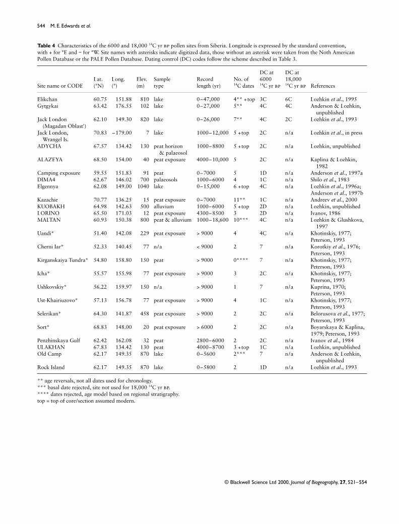
544 M. E. Edwards et al.
© Blackwell Science Ltd 2000, Journal of Biogeography, 27, 521–554
Table 4 Characteristics of the 6000 and 18,000 14C yr bp pollen sites from Siberia. Longitude is expressed by the standard convention, with + for °E and − for °W. Site names with asterisks indicate digitized data, those without an asterisk were taken from the Noth American Pollen Database or the PALE Pollen Database. Dating control (DC) codes follow the scheme described in Table 3.
Site name or CODELat. (°N)
Long. (°)
Elev. (m)
Sample type
Record length (yr)
No. of 14C dates
DC at 600014C yr bp
DC at 18,00014C yr bp References
Elikchan 60.75 151.88 810 lake 0–47,000 4** +top 3C 6C Lozhkin et al., 1995Gytgykai 63.42 176.55 102 lake 0–27,000 5** 4C 4C Anderson & Lozhkin,
unpublishedJack London
(Magadan Oblast′)62.10 149.30 820 lake 0–26,000 7** 4C 2C Lozhkin et al., 1993
Jack London, Wrangel Is.
70.83 –179.00 7 lake 1000–12,000 5 +top 2C n/a Lozhkin et al., in press
ADYCHA 67.57 134.42 130 peat horizon & palaeosol
1000–8800 5 +top 2C n/a Lozhkin, unpublished
ALAZEYA 68.50 154.00 40 peat exposure 4000–10,000 5 2C n/a Kaplina & Lozhkin, 1982
Camping exposure 59.55 151.83 91 peat 0–7000 5 1D n/a Anderson et al., 1997aDIMA4 62.67 146.02 700 palaeosols 1000–6000 4 1C n/a Shilo et al., 1983Elgennya 62.08 149.00 1040 lake 0–15,000 6 +top 4C n/a Lozhkin et al., 1996a;
Anderson et al., 1997bKazachie 70.77 136.25 15 peat exposure 0–7000 11** 1C n/a Andreev et al., 2000KUOBAKH 64.98 142.63 500 alluvium 1000–6000 5 +top 2D n/a Lozhkin, unpublishedLORINO 65.50 171.03 12 peat exposure 4300–8500 3 2D n/a Ivanov, 1986MALTAN 60.93 150.38 800 peat & alluvium 1000–18,600 10*** 4C n/a Lozhkin & Glushkova,
1997Uandi* 51.40 142.08 229 peat exposure > 9000 4 4C n/a Khotinskiy, 1977;
Peterson, 1993Cherni Iar* 52.33 140.45 77 n/a < 9000 2 7 n/a Korotkiy et al., 1976;
Peterson, 1993Kirganskaiya Tundra* 54.80 158.80 150 peat > 9000 0**** 7 n/a Khotinskiy, 1977;
Peterson, 1993Icha* 55.57 155.98 77 peat exposure > 9000 3 2C n/a Khotinskiy, 1977;
Peterson, 1993Ushkovskiy* 56.22 159.97 150 n/a > 9000 1 7 n/a Kuprina, 1970;
Peterson, 1993Ust-Khairiuzovo* 57.13 156.78 77 peat exposure > 9000 4 1C n/a Khotinskiy, 1977;
Peterson, 1993Selerikan* 64.30 141.87 458 peat exposure > 9000 2 2C n/a Belorusova et al., 1977;
Peterson, 1993Sort* 68.83 148.00 20 peat exposure > 6000 2 2C n/a Boyarskaya & Kaplina,
1979; Peterson, 1993Penzhinskaya Gulf 62.42 162.08 32 peat 2800–6000 2 2C n/a Ivanov et al., 1984ULAKHAN 67.83 134.42 130 peat 4000–8700 3 +top 1C n/a Lozhkin, unpublishedOld Camp 62.17 149.35 870 lake 0–5600 2*** 7 n/a Anderson & Lozhkin,
unpublishedRock Island 62.17 149.35 870 lake 0–5800 2 1D n/a Lozhkin et al., 1993
** age reversals, not all dates used for chronology.*** basal date rejected, site not used for 18,000 14C yr bp.**** dates rejected, age model based on regional stratigraphy.top = top of core/section assumed modern.
JBI426.fm Page 544 Wednesday, November 15, 2000 3:48 PM

Biome reconstructions for Beringia 545
© Blackwell Science Ltd 2000, Journal of Biogeography, 27, 521–554
Table 5 Assignments of pollen taxa from Beringia to the plant functional types (PFTs) used in the biomization procedure.
Abbr. Plant functional type Pollen taxa
aa arctic/alpine dwarf shrub Alnus viridis, Alnus, Alnus fructicosa-type, Alnaster, Betulaceae, Betula, Betula exilis, Betula sect. Nanae, Betula nana, Betula nana-type, Betula shrub, Dryas, Rhododendron, Rosaceae, Salix, Spiraea
ab arctic/boreal dwarf shrub Rubus arcticus, Rubus chamaemorusaf arctic/alpine forb Aconitum, Allium, Alliaceae, Ambrosia-type, Apiaceae, Asteraceae undiff., Asteraceae subf.
Cichorioideae, Asteroideae, Brassicaceae, Bupleurum, Campanulaceae, Cardamine, Cichoroideae, Circea alpina, Compositae, Crassulaceae, cf. Crassulaceae, Cruciferae, Caryophyllaceae, Dodecatheon-type, Epilobium, Epilobium angustifolium, Fabaceae, Filipendula, Galium, Gentianaceae, Gentiana, Hedysarum-type, Koenigia, Koenigia islandica, Lagotis, Leguminosae, Liguliflorae, Liliaceae, cf. Liliaceae, Lupinus, Onagraceae, Pedicularis, Pedicularis langsdorfii, Pedicularis verticilliata, Plantago maritima, Polygonaceae, Polemoniaceae, Polemonium, Polygonum bistorta-type, Polygonum viviparum, Polygonum sect. bistorta, Potentilla, Primulaceae, Ranunculaceae, Ranuculus, Rosaceae, Rubiaceae, Rubus, Rumex, Rumex arcticus, Rumex/Oxyria, Rumex/Oxyria digyna, Sanguisorba, Saussurea, Saxifragaceae undiff., Saxifraga, Saxifraga cernua-type, Saxifraga foliosa-type, Saxifraga hieracifolia-type, Saxifraga tricuspidata, Saxifraga tricuspidata-type, Scrophulariaceae, Senecio, Sedum, Stellaria, Taraxacum, Thalictrum, Tubuliflorae, Umbelliferae, Valerianaceae, Valeriana, Valeriana egnifata
ah arctic heath Cassiope, Diapensiabec boreal evergreen conifer Abies, Picea, Picea sect. eupicea, Picea glauca, Picea marianabf boreal forb Aconitum, Alliaceae, Allium, Ambrosia-type, Asteraceae undiff., Asteraceae subf.
Cichorioideae, Asteroideae, Boraginaceae, Cardamine, Cichorioideae, Compositae, Coptis, Epilobium, Epilobium angustifolium, Fabaceae, Filipendula, Fragaria, Galium, Geraniaceae, Geranium erianthum, Hedysarum-type, Labiatae undiff., Lamiaceae, Leguminosae, Liguliflorae, Liliaceae, cf. Liliaceae, Linnaea, Mentha-type, Mertensia, Onagraceae, Parnassia, Plantago maritima, Polemoniaceae, Polemonium, Ranunculaceae, Ranunculus, Rosaceae, Rubiaceae, Rubus, Rumex, Rumex arcticus, Rumex/Oxyria, Rumex/Oxyria digyna, Sanguisorba, Senecio, Tubuliflorae, Valerianaceae, Valeriana, Valeriana egnifata, Viola
bs boreal summergreen Alnus undiff., Alnus glutinosa, Alnus incana, Alnus viridis, Alnus fruticosa-type, Alnaster, Betulaceae, Betula undiff., Betula arbor s. Albae, Betula a., Betula albae, Betula arbor., Betula fruticosa, Betula platyphylla, Chosenia, Cornaceae, Cornus, Cornus canadensis, Cornus sericea, Myrica, cf. Myrica, Populus, Populus balsamifera, Populus tremuloides, Salix
bsc boreal summergreen conifer Larix, Larix gmeliniibts boreal-temperate summergreen shrub Caprifoliaceae, Lonicera, Ribes, Rosaceae, Sambucus, Shepherdia, Shepherdia canadensis,
Spiraea, Viburnum, cf. Viburnum, Viburnum opuluscbc cool-boreal conifer shrub Pinus pumila; in Siberia Pinus, Pinus (Haploxylon) also includedctc cool-temperate conifer Abies, Tsuga, Tsuga heterophylla, Tsuga mertensianadtf dry tundra forb Androsace, Anemone-type, Arnica, Astragalus-type, Draba, Oxyria digyna, Oxytropis,
Papaveraceae, Papaver, Phlox, Plantago undiff., Plantago canescens-type, Plantago major-type, Plantaginaceae, Saxifraga oppositifolia, Selaginella siberica
ec eurythermic conifer Cupressaceae, Juniperus, Pinaceae, Pinus (Haploxylon), Pinus contorta, Pinus subg. Pinus, Pinus sect., Pinus sylvestris, Pinus subg. Strobus; in Alaska Pinus, Pinus (Diploxylon) also included
g grass Gramineae, Poaceaeh heath Arctostaphylos, Empetrum, Ericaceae undiff., Ericales, Ledum-type, Pyrolaceae, Pyrola,
Vaccinium-types sedge Cyperaceaesf steppe forb Allium, Alliaceae, Amarantha, Ambrosia-type, Anemone-type, Apiaceae, Artemisia,
Asteraceae subf. Cichorioideae, Asteraceae undiff., Asteroideae, Boraginaceae, Brassicaceae, Bupleurum, Campanulaceae, Cichorioideae, Compositae, Crassulaceae, cf. Crassulaceae, Cruciferae, Caryophyllaceae, Dodecatheon-type, Epilobium, Fabaceae, Galium, Geraniaceae, Labiatae undiff., Lamiaceae, Leguminosae, Liguliflorae, Liliaceae, cf. Liliaceae, Mentha-type, Onagraceae, Oxytropis, Plantago undiff., Plantago major-type, Plantaginaceae, Plumbaginaceae, Polygonaceae, Potentilla, Primulaceae, Ranunculaceae, Ranunculus, Rosaceae, Rubiaceae, Rumex, Rumex/Oxyria digyna, Rumex/Oxyria, Saxifragaceae undiff., Saxifraga, Saxifraga hierac-type, Saxifraga tricuspidata, Saxifraga tricuspidata-type, Scrophulariaceae, Senecio, Sedum, Stellaria, Taraxacum, Tubuliflorae, Umbelliferae, Valerianaceae, Valeriana, Valariana egnifata
tf temperate forb Allium, Alliaceae, Cardamine, Coptis, Epilobium angustifolium, Fabaceae, Fragaria, Geranium erianthum, Labiatae undiff., Lamiaceae, Leguminosae, Liliaceae, cf. Liliaceae, Mertensia, Parnassia, Ranunculus, Rubus, Spiraea, Stellaria, Taraxacum, Valerianaceae, Valeriana, Valeriana egnifata, Viola
xf xeric forb Amarantha, Chenopodiaceae, Chenopod/Amaranth, Ephedra, Polygonaceae
JBI426.fm Page 545 Wednesday, November 15, 2000 3:48 PM
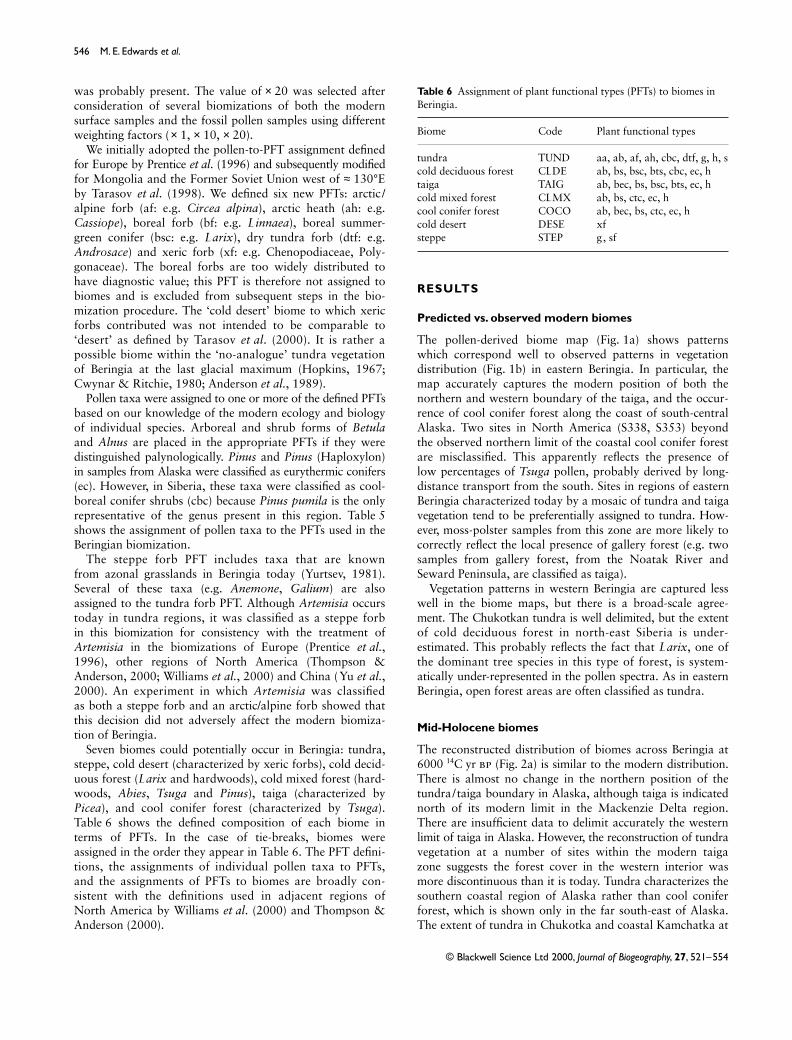
546 M. E. Edwards et al.
© Blackwell Science Ltd 2000, Journal of Biogeography, 27, 521–554
was probably present. The value of × 20 was selected afterconsideration of several biomizations of both the modernsurface samples and the fossil pollen samples using differentweighting factors (× 1, × 10, × 20).
We initially adopted the pollen-to-PFT assignment definedfor Europe by Prentice et al. (1996) and subsequently modifiedfor Mongolia and the Former Soviet Union west of ≈ 130°Eby Tarasov et al. (1998). We defined six new PFTs: arctic /alpine forb (af: e.g. Circea alpina), arctic heath (ah: e.g.Cassiope), boreal forb (bf: e.g. Linnaea), boreal summer-green conifer (bsc: e.g. Larix), dry tundra forb (dtf: e.g.Androsace) and xeric forb (xf: e.g. Chenopodiaceae, Poly-gonaceae). The boreal forbs are too widely distributed tohave diagnostic value; this PFT is therefore not assigned tobiomes and is excluded from subsequent steps in the bio-mization procedure. The ‘cold desert’ biome to which xericforbs contributed was not intended to be comparable to‘desert’ as defined by Tarasov et al. (2000). It is rather apossible biome within the ‘no-analogue’ tundra vegetationof Beringia at the last glacial maximum (Hopkins, 1967;Cwynar & Ritchie, 1980; Anderson et al., 1989).
Pollen taxa were assigned to one or more of the defined PFTsbased on our knowledge of the modern ecology and biologyof individual species. Arboreal and shrub forms of Betulaand Alnus are placed in the appropriate PFTs if they weredistinguished palynologically. Pinus and Pinus (Haploxylon)in samples from Alaska were classified as eurythermic conifers(ec). However, in Siberia, these taxa were classified as cool-boreal conifer shrubs (cbc) because Pinus pumila is the onlyrepresentative of the genus present in this region. Table 5shows the assignment of pollen taxa to the PFTs used in theBeringian biomization.
The steppe forb PFT includes taxa that are knownfrom azonal grasslands in Beringia today (Yurtsev, 1981).Several of these taxa (e.g. Anemone, Galium) are alsoassigned to the tundra forb PFT. Although Artemisia occurstoday in tundra regions, it was classified as a steppe forbin this biomization for consistency with the treatment ofArtemisia in the biomizations of Europe (Prentice et al.,1996), other regions of North America (Thompson &Anderson, 2000; Williams et al., 2000) and China (Yu et al.,2000). An experiment in which Artemisia was classifiedas both a steppe forb and an arctic/alpine forb showed thatthis decision did not adversely affect the modern biomiza-tion of Beringia.
Seven biomes could potentially occur in Beringia: tundra,steppe, cold desert (characterized by xeric forbs), cold decid-uous forest (Larix and hardwoods), cold mixed forest (hard-woods, Abies, Tsuga and Pinus), taiga (characterized byPicea), and cool conifer forest (characterized by Tsuga).Table 6 shows the defined composition of each biome interms of PFTs. In the case of tie-breaks, biomes wereassigned in the order they appear in Table 6. The PFT defini-tions, the assignments of individual pollen taxa to PFTs,and the assignments of PFTs to biomes are broadly con-sistent with the definitions used in adjacent regions ofNorth America by Williams et al. (2000) and Thompson &Anderson (2000).
RESULTS
Predicted vs. observed modern biomes
The pollen-derived biome map (Fig. 1a) shows patternswhich correspond well to observed patterns in vegetationdistribution (Fig. 1b) in eastern Beringia. In particular, themap accurately captures the modern position of both thenorthern and western boundary of the taiga, and the occur-rence of cool conifer forest along the coast of south-centralAlaska. Two sites in North America (S338, S353) beyondthe observed northern limit of the coastal cool conifer forestare misclassified. This apparently reflects the presence oflow percentages of Tsuga pollen, probably derived by long-distance transport from the south. Sites in regions of easternBeringia characterized today by a mosaic of tundra and taigavegetation tend to be preferentially assigned to tundra. How-ever, moss-polster samples from this zone are more likely tocorrectly reflect the local presence of gallery forest (e.g. twosamples from gallery forest, from the Noatak River andSeward Peninsula, are classified as taiga).
Vegetation patterns in western Beringia are captured lesswell in the biome maps, but there is a broad-scale agree-ment. The Chukotkan tundra is well delimited, but the extentof cold deciduous forest in north-east Siberia is under-estimated. This probably reflects the fact that Larix, one ofthe dominant tree species in this type of forest, is system-atically under-represented in the pollen spectra. As in easternBeringia, open forest areas are often classified as tundra.
Mid-Holocene biomes
The reconstructed distribution of biomes across Beringia at6000 14C yr bp (Fig. 2a) is similar to the modern distribution.There is almost no change in the northern position of thetundra/taiga boundary in Alaska, although taiga is indicatednorth of its modern limit in the Mackenzie Delta region.There are insufficient data to delimit accurately the westernlimit of taiga in Alaska. However, the reconstruction of tundravegetation at a number of sites within the modern taigazone suggests the forest cover in the western interior wasmore discontinuous than it is today. Tundra characterizes thesouthern coastal region of Alaska rather than cool coniferforest, which is shown only in the far south-east of Alaska.The extent of tundra in Chukotka and coastal Kamchatka at
Table 6 Assignment of plant functional types (PFTs) to biomes in Beringia.
Biome Code Plant functional types
tundra TUND aa, ab, af, ah, cbc, dtf, g, h, scold deciduous forest CLDE ab, bs, bsc, bts, cbc, ec, htaiga TAIG ab, bec, bs, bsc, bts, ec, hcold mixed forest CLMX ab, bs, ctc, ec, hcool conifer forest COCO ab, bec, bs, ctc, ec, hcold desert DESE xfsteppe STEP g, sf
JBI426.fm Page 546 Wednesday, November 15, 2000 3:48 PM

Biome reconstructions for Beringia 547
© Blackwell Science Ltd 2000, Journal of Biogeography, 27, 521–554
Figure 2 Biomes reconstructed from fossil pollen data at (a) 6000 14C yr bp and (b) 18,000 14C yr bp.
JBI426.fm Page 547 Wednesday, November 15, 2000 3:48 PM

548 M. E. Edwards et al.
© Blackwell Science Ltd 2000, Journal of Biogeography, 27, 521–554
6000 14C yr bp is similar to today. Given the problem of Larixrepresentation in the pollen record, the reconstruction oftundra in areas of the Yana-Indigirka-Kolyma lowland cannotbe interpreted as reliably indicating a southward shift in thenorthern limit of cold deciduous forest in western Siberia at6000 14C yr bp. In accord with other interpretations of the data,our reconstructions provide no evidence of an expansion ofother biomes (e.g. taiga or cold mixed forest) into the regionoccupied today by cold deciduous forest.
Last glacial maximum biomes
In contrast to the situation at 6000 14C yr bp, the predicteddistribution of biomes at 18,000 14C yr bp was very differentfrom today. The biome map for 18,000 14C yr bp (Fig. 2b)shows tundra across the whole of Beringia. However, theimportance of component tundra PFTs differs from region toregion (Table 7). For example, at Kaiyak Lake (Anderson, 1985)steppe forbs (sf) are strongly represented, whereas at Sands ofTime Lake (Lamb & Edwards, 1988) the xeric forb (xf) PFTis quite prominent, and at Jack London, Magadan (Lozhkinet al., 1993) shrub and heath PFTs (aa, h, bs) are important.
DISCUSSION AND CONCLUSIONS
The biomization method
The biomization method appears to capture the broad-scalefeatures of the modern vegetation patterns across Beringiareasonably well, except that it fails to predict the observedextent of the Larix-dominated cold deciduous forest in westernBeringia. Correctly defining the limits of Larix-dominatedforest from pollen data is difficult because of the poor repres-entation of Larix in the pollen record. Although our use of aweighting factor for Larix increases the number of sitescorrectly assigned to cold deciduous forest, weighting is onlyeffective when Larix pollen is actually present in a sample.One possible solution to this problem would be to average
the pollen spectra of several samples within a specified window(e.g. 6000 ± 500 yr) and use this composite spectrum forbiomization. Such an approach would enhance the representa-tion of Larix because, although not present in every sample,Larix pollen tends to be present in some samples within abroader time series. An alternative approach might be to usemacrofossil records in conjunction with the pollen data froma given site.
Vegetation and climate of Beringia at 6000 14C yr BP
The biome map (Fig. 2a) shows that northern treeline inwestern Beringia and Alaska was similar to present at6000 14C yr bp. In northern Alaska, there is no macrofossilevidence that Picea occurred further north than today at anystage during the Holocene (Hopkins et al., 1981) and the pollenrecord has consistently been interpreted as showing that theposition of northern treeline in this region was similar to today(e.g. Brubaker et al., 1983; Anderson, 1985, 1988). The bio-mised data, although somewhat noisy, indicate that treeline wasfurther north than today in the lower Mackenzie-Tuktoyaktukregion. There was a treeline advance in north-western Canadain the early Holocene, and dated macrofossils show thatPicea grew north of its modern limit as late as 6000 14C yr bp(Ritchie & Hare, 1971; Ritchie et al., 1983; Spear, 1983; Ritchie,1984a). Our data appear to reflect the waning stages of thisearly Holocene treeline advance, and underscore differencesin treeline response between Alaska and the easternmost partof the Beringian region. Macrofossil evidence also suggeststhat treeline was further north in western Beringia duringthe early Holocene (Khotinskiy, 1984), but it is not possibleto detect any residual treeline extension from the biome mapfor 6000 14C yr bp. Biome reconstructions for other regionsof the Arctic (e.g. Prentice et al., 1996; Texier et al., 1997;Tarasov et al., 1998) indicate that treeline was considerablyfurther north than today, with the greatest northward shift(of up to 200–300 km) in central Siberia. Arctic tree lineextensions during the mid-Holocene have been interpreted
Table 7 Percentage contribution of different plant functional types (PFTs), derived from the biomization procedure, in LGM pollen samples from Beringia. The PFT codes are defined in Table 5. PFTs contributing to the tundra biome are listed first.
Tundra PFTs Other forb PFTs Other tree/shrub PFTs
Site aa af dtf g s h bf sf tf xf bec bs bsc bts ec
Antifreeze Pond 26.2 7.7 0.0 11.5 12.6 0.0 5.0 9.2 0.0 0.0 2.8 25.1 0.0 0.0 0.0Hanging Lake 20.9 9.9 2.0 10.5 4.8 0.0 6.4 18.4 2.0 2.0 3.4 21.7 0.0 0.8 0.0Ranger Lake 15.7 4.8 0.0 15.9 17.3 0.0 2.4 19.9 0.0 3.4 0.0 20.5 0.0 0.0 0.0Rebel Lake 13.7 11.5 0.0 14.2 9.2 0.0 6.6 28.7 0.0 4.7 0.0 11.4 0.0 2.3 0.0Joe Lake 16.8 9.4 0.0 16.8 17.9 0.0 6.1 16.2 0.0 0.0 0.0 16.8 0.0 0.0 0.0Kaiyak Lake 6.2 21.7 0.0 15.8 5.9 0.0 9.1 27.8 0.0 0.0 0.0 4.5 9.0 1.8 0.0Tiinkdhul Lake 8.0 6.6 0.0 13.1 40.1 0.0 6.6 9.8 0.0 6.1 1.8 8.0 0.0 0.0 0.0Sands of Time Lake 14.0 6.4 0.0 11.0 15.3 0.0 6.4 11.8 0.0 12.5 6.5 16.0 0.0 0.0 0.0Elikchan 9.0 27.0 0.0 9.3 5.5 1.1 8.2 28.2 1.1 0.0 0.0 7.9 0.0 1.1 3.9Gytgykai 8.5 4.3 0.0 23.2 28.6 0.0 0.0 20.5 0.0 4.3 2.1 8.5 0.0 0.0 0.0Jack London (M) 32.9 1.5 0.0 7.9 0.0 4.1 1.5 17.6 0.0 0.0 0.0 32.9 0.0 0.0 1.5
JBI426.fm Page 548 Wednesday, November 15, 2000 3:48 PM

Biome reconstructions for Beringia 549
© Blackwell Science Ltd 2000, Journal of Biogeography, 27, 521–554
as indicating increased growing-season warmth as a result oforbitally induced insolation changes (e.g. TEMPO, 1996;Prentice et al., 2000). Our reconstructions demonstrate thatthere was a strong regionalization to this circum-polarwarming. They suggest that other, indirect responses to orbitalforcing (e.g. variations in the East Asian trough-ridge systemor changes in circulation in the Arctic Ocean) may have playedan important role in determining Arctic regional climatesduring the mid-Holocene (see Ritchie & Hare, 1971). Mac-Donald et al. (1993) also noted the apparent asymmetry ofHolocene treeline extensions. This asymmetry has not beenseen in climate model simulations to date (e.g. TEMPO,1996; Harrison et al., 1998; Joussaume et al., 1998).
There are insufficient data to delimit accurately the westernlimit of taiga in Alaska at 6000 14C yr bp. However, themixture of tundra and taiga in the central and western interiorof Alaska, which we interpret as indicating that the forestcover was less complete than today, is consistent with datathat indicate that the westward spread of Picea was notcompleted until after 6000 14C yr bp (Anderson & Brubaker,1994; Edwards & Barker, 1994; Hu et al., 1996).
The presence of tundra in southern coastal Alaska, incontrast to today’s cool conifer forest, may indicate thatwinters were colder than present and exceeded the tolerancesof Tsuga and Picea sitchensis, although some factor other thanwinter cold must also have limited the spread of P. glaucaand P. mariana to the coast (Lozhkin et al., 1993). The west-ward limitation of Picea in Alaska may reflect an enhancedeast–west summer temperature gradient, with advection due toa strong Pacific subtropical high causing a relative cooling ofthe Alaskan coast and adjacent regions (see e.g. Ritchie &Hare, 1971; Mock et al., 1998).
There is no evidence that the cold deciduous forests ofwestern Beringia were less extensive at 6000 14C yr bpthan they are today. Cold deciduous forests are confined toregions where the winter temperatures exceed the limits forthe growth of boreal evergreen conifers (Prentice et al., 1992).Thus, the fact that biomes such as taiga, cool conifer, or coldmixed forests do not encroach on the cold deciduous forestzone in western Beringia indicates that winters were not sig-nificantly warmer than today. This climatic interpretation isconsistent with evidence from Japan (Takahara et al., 2000).
Vegetation and climate of Beringia at the last glacial maximum
Our reconstructions show that Beringia was covered bytundra vegetation at the last glacial maximum. The occur-rence of tundra across Beringia at the LGM is consistent witha significant, and most likely year-round, cooling. A large cool-ing is also implied by the biome reconstructions in adjacentregions of western Siberia (Tarasov et al., 2000), northernChina (Yu et al., 2000) and Japan (Takahara et al., 2000). Sucha cooling suggests that the southerly flow along the westernedge of the North American ice sheet that is observed inmany palaeoclimatic simulations (e.g. Broccoli & Manabe,1987; Kutzbach et al., 1993; Kutzbach et al., 1998) did notresult in significant warming in Beringia, nor did it lead to
significantly warmer conditions in Beringia than in adjacentregions. Differences in the relative abundance of PFTs fromsite to site support the widely accepted idea that the vegeta-tion of Beringia was a mosaic of different tundra types(Ritchie & Cwynar, 1982; Schweger, 1982). A more detailedsubdivision of tundra, based on an analysis of the modernphysiologic and bioclimatic limits of Arctic PFTs, would behelpful in order to analyse the climatic implications of vari-ation in tundra vegetation types across Beringia.
ACKNOWLEDGMENTS
The biomization described here was begun at the BIOME6000 regional workshop for Beringia and Japan (October15th-29th 1997, Lund, Sweden), which was funded by theInternational Geosphere-Biosphere Programme (IGBP) throughthe IGBP Data and Information System (IGBP-DIS), the GlobalAnalysis, Interpretation and Modelling (IGBP-GAIM) taskforce, and the PAst Global changES (IGBP-PAGES) coreproject. We thank Ben Smith for making the BIOMISE pro-gram available to us, Matt Duvall (PARCS Data Coordinator)and F. Dobos for assistance with data compilation, ColinPrentice for advice on biomization techniques, Dave Murray,Skip Walker, Volodya Razzhivin and Nadja Matveyeva fordiscussions about Arctic plant functional types, and ColinPrentice and Patrick Bartlein for reviews of an earlier draftof the manuscript. The North American Pollen Databasecan be accessed at http://www.museum.state.il.us/research/napd/ and the PARCS database at http://www.ngdc.noaa.gov/paleo/parcs/. This paper is a contribution to the PALE/PARCS initiative, to BIOME 6000, to TEMPO (TestingEarth system Models with Paleoenvironmental Observations)and to the Palaeoclimate Modelling Intercomparison Project(PMIP).
REFERENCES
Ager, T. A. (1983) Holocene vegetation history of Alaska. LateQuaternary environments of the United States, Vol. 2. TheHolocene (ed. by H. E. Wright Jr), pp. 128–140. Universityof Minnesota Press, Minneapolis.
Ager, T. A. & Brubaker, L. B. (1985) Quaternary palynology andvegetation history of Alaska. Pollen records of Late-QuaternaryNorth American sediments (ed. by V. M. Bryant Jr andR. G. Holloway), pp. 353–384. American Association ofStratigraphic Palynologists, Dallas.
Aleksandrova, V. D. (1977) Geobotanicheskoe RaionirovanieArktiki i Antarktiki, 186 pp. Nauka, Leningrad (in Russian).
Ananyeyev, G. S., Bespaly, V. G., Glushkova, O. Yu., Ivanov, V. F.,Kolpalov, V. V. & Prokhorova, T. P. (1993) Stratigraphy andpaleogeography of the late Pleistocene. Evolution of landscapesand climates of the Northern Eurasia (ed. by A. A. Velichko),pp. 59–62. Nauka, Moscow (in Russian).
Anderson, P. M. (1985) Late Quaternary vegetational change inthe Kotzebue Sound area, northwestern Alaska. QuaternaryResearch, 24, 307–321.
Anderson, P. M. (1988) Late Quaternary pollen records from theKobuk and Noatak River drainages, northwestern Alaska.Quaternary Research, 29, 263–276.
JBI426.fm Page 549 Wednesday, November 15, 2000 3:48 PM

550 M. E. Edwards et al.
© Blackwell Science Ltd 2000, Journal of Biogeography, 27, 521–554
Anderson, P. M., Bartlein, P. J., Brubaker, L. B., Gajewski, K. &Ritchie, J. C. (1989) Modern analogues of Late-Quaternarypollen spectra from the western interior of North America.Journal of Biogeography, 16, 573–596.
Anderson, P. M. & Brubaker, L. B. (1993) Holocene vegetationand climate histories of Alaska. Global climates since thelast glacial maximum (ed. by H. E. Wright Jr, J. E. Kutzbach,T. Webb III, W. F. Ruddiman, F. A. Street-Perrott and P. J. Bartlein),pp. 386–400. University of Minnesota Press, Minneapolis.
Anderson, P. M. & Brubaker, L. B. (1994) Vegetation history ofnorthcentral Alaska: a mapped summary of Late-Quaternarypollen data. Quaternary Science Reviews, 13, 71–92.
Anderson, P. M. & Lozhkin, A. V. (1995) Late Quaternarylacustrine pollen records from northwestern Beringia: newresults and paleoenvironmental implications. Geology of thePacific Ocean, 14, 8–17.
Anonymous (1990) Geographical atlas of the USSR. CentralAdministration of the Geodesic and Cartographic Ministry,Moscow.
Barnosky, C. W., Anderson, P. M. & Bartlein, P. J. (1987) Thenorthwestern U. S. during deglaciation; vegetational historyand paleoclimatic implications. North America and adjacentoceans during the last deglaciation (ed. by W. F. Ruddimanand H. E. Wright Jr), pp. 289–321. The Geology of NorthAmerica, Vol. K-3, Geological Society of America, Boulder,Colorado.
Bartlein, P. J., Anderson, P. M., Edwards, M. E. & McDowell, P. F.(1992) A framework for interpreting paleoclimatic variationsin eastern Beringia. Quaternary International, 10–12, 73–83.
Broccoli, A. J. & Manabe, S. (1987) The influence of continentalice, atmospheric CO2, and land albedo on the climate of the lastglacial maximum. Climate Dynamics, 1, 87–99.
Brubaker, L. B., Garfinkel, H. L. & Edwards, M. E. (1983) Alate Wisconsin and Holocene vegetation history for the centralBrooks Range: implications for Alaskan paleoecology. Quatern-ary Research, 20, 194–214.
Chen, S. J., Kuo, Y. H., Zhang, P. Z. & Bai, Q. F. (1991)Synoptic climatology of cyclogenesis over East Asia, 1958–1987. Monthly Weather Review, 119, 1407–1418.
Cwynar, L. C. & Ritchie, J. C. (1980) Arctic steppe-tundra: aYukon perspective. Science, 208, 1375–1377.
Edwards, M. E. & Barker, E. D. (1994) Climate and vegetationin northern Alaska 18,000 yr — present. Palaeogeography,Palaeoclimatology, Palaeoecology, 109, 127–135.
Foley, J. A., Kutzbach, J. E., Coe, M. T. & Levis, S. (1994)Feedbacks between climate and boreal forests during theHolocene epoch. Nature, 371, 52–54.
Foley, J. A., Levis, S., Prentice, I. C., Pollard, D. & Thompson, S. L.(1998) Coupling dynamic models of climate and vegetation.Global Change Biology, 4, 561–579.
Hamilton, T. D. & Thorson, R. M. (1983) The Cordilleran icesheet in Alaska. Late-Quaternary environments of the UnitedStates, Vol. 1. The Late Pleistocene (ed. by S. C. Porter),pp. 38–52. University of Minnesota Press, Minneapolis.
Hare, F. K. & Hay, J. E. (1974) The climate of Canada and Alaska.Climates of North America (ed. by R. A. Bryson and F. K. Hare),pp. 49–192. World Survey of Climatology, Vol. 11. Elsevier,New York.
Harman, J. R. (1991) Synoptic climatology of the Westerlies:process and patterns. Association of American Geographers,Washington, D.C.
Harrison, S. P., Jolly, D., Laarif, F., Abe-Ouchi, A., Dong, B.,Herterich, K., Hewitt, C., Joussaume, S., Kutzbach, J. E.,Mitchell, J., de Noblet, N. & Valdes, P. (1998) Intercomparisonof simulated global vegetation distribution in response to6 kyr B.P. orbital forcing. Journal of Climate, 11, 2721–2742.
Harrison, S. P., Kutzbach, J. E., Prentice, I. C., Behling, P. &Sykes, M. T. (1995) The reponse of northern hemisphere extra-tropical climate and vegetation to orbitally-induced changes ininsolation during the last interglacial: results of atmosphericgeneral circulation model and biome simulations. Quatern-ary Research, 43, 174–184.
Haxeltine, A. & Prentice, I. C. (1996) BIOME3: an equilibriumbiosphere model based on ecophysiological constraints, resourceavailability and competition among plant functional types.Global Biogeochemical Cycles, 10, 693–709.
Hopkins, D. M. (1967) The Bering Land Bridge. Stanford Univer-sity Press, Stanford, California.
Hopkins, D. M., Matthews, J. V., Jr, Schweger, C. E. & Young, S. B.(eds) (1982) Paleoecology of Beringia. Academic Press, New York.
Hopkins, D. M., Smith, P. A. & Matthews, J. V. (1981) Datedwood from Alaska and the Yukon: implications for forest refugiain Beringia. Quaternary Research, 15, 217–249.
Hu, F. S., Brubaker, L. B. & Anderson, P. M. (1996) Boreal eco-system development in the northwestern Alaska Range since11,000 yr b.p. Quaternary Research, 45, 188–201.
Jolly, D., Harrison, S. P., Damnati, B. & Bonnefille, R. (1998)Simulated climate and biomes of Africa during the Late Qua-ternary: comparison with pollen and lake status data. Quatern-ary Science Reviews, 17, 629–657.
Joussaume, S., Taylor, K. E., Braconnot, P., Mitchell, J. F. B.,Kutzbach, J. E., Harrison, S. P., Prentice, I. C., Broccoli, A. J.,Abe-Ouchi, A., Bartlein, P. J., Bonfils, C., Dong, B., Guiot, J.,Herterich, K., Hewitt, C. D., Jolly, D., Kim, J. W., Kislov, A.,Kitoh, A., Loutre, M. F., Masson, V., McAvaney, B.,McFarlane, N., de Noblet, N., Peltier, W. R., Peterschmitt, J. Y.,Pollard, D., Rind, D., Royer, J. F., Schlesinger, M. E., Syktus, J.,Thompson, S., Valdes, P., Vettoretti, G., Webb, R. S. & Wyputta,U. (1998) Monsoon changes for 6000 years ago: results of 18simulations from the Paleoclimate Modeling IntercomparisonProject (PMIP). Geophysical Research Letters, 26, 859–862.
Khokhryakov, A. P. (1985) Flora of Magadan Oblast. Nauka,Moscow (in Russian).
Khotinskiy, N. A. (1984) Holocene climatic changes. Late Quatern-ary environments of the Soviet Union (ed. by A. A. Velichko,H. E. Wright Jr and C. W. Barnosky), pp. 305–309. Universityof Minnesota Press, Minnesota.
Kozhevnikov, Yu. P. (1989) The geography of the vegetation ofChukotka. Nauka, Leningrad (in Russian).
Kubatzki, C., Ganopolski, A., Claussen, M., Brovkin, V. &Petoukhov, V. (1998) The importance of vegetation feedbacksand the role of the ocean for palaeoclimate simulations. TheEarth’s changing land. GCTE-LUCC Open Science Confer-ence on Global Change, Abstracts, p. 87.
Kutzbach, J. E. & Gallimore, R. G. (1988) Sensitivity of a coupledatmosphere/mixed layer ocean model to changes in orbitalforcing at 9000 years b.p. Journal of Geophysical Research,93, 803–821.
Kutzbach, J. E., Gallimore, R., Harrison, S. P., Behling, P.,Selin, R. & Laarif, F. (1998) Climate and biome simulationsfor the past 21,000 years. Quaternary Science Reviews, 17,473–506.
JBI426.fm Page 550 Wednesday, November 15, 2000 3:48 PM

Biome reconstructions for Beringia 551
© Blackwell Science Ltd 2000, Journal of Biogeography, 27, 521–554
Kutzbach, J. E., Guetter, P. J., Behling, P. & Selin, R. (1993)Simulated climatic changes: results of the COHMAP climate-model experiments. Global climates since the last glacial max-imum (ed. by H. E. Wright Jr, J. E. Kutzbach, T. Webb III,W. F. Ruddiman, F. A. Street-Perrott and P. J. Bartlein),pp. 24–93. University of Minnesota Press, Minneapolis.
Lamb, H. F. & Edwards, M. E. (1988) The Arctic. Vegetationhistory (ed. by B. Huntley and T. Webb III), pp. 519–555.Kluwer Academic Publishers, Dordrecht.
Lozhkin, A. V. & Anderson, P. M. (1995) A late Quaternarypollen record from Elikchan 4 Lake, northeast Siberia. Geologyof the Pacific Ocean, 14, 18–22.
Lozhkin, A. V., Anderson, P. M., Eisner, W. R., Ravako, L. G.,Hopkins, D. M., Brubaker, L. B., Colinvaux, P. A. & Miller,M. C. (1993) Late Quaternary lacustrine pollen records fromsouthwestern Beringia. Quaternary Research, 9, 314–324.
Lydolph, P. E. (1977) Climates of the Soviet Union. World Surveyof Climatology, Vol. 7. Elsevier Scientific Publishing Co., NewYork.
MacDonald, G. M., Edwards, T. W. D., Moser, K. A., Pienitz, R.& Smol, J. P. (1993) Rapid response of treeline vegetationand lakes to past climate warming. Nature, 361, 243–246.
Melillo, J., Prentice, I. C., Schulze, E.-D., Farquhar, G. & Sala, O.(1996) Terrestrial biotic responses to environmental changeand feedbacks to climate. Climate change 1995: the scienceof climate change (ed. by J. T. Houghton, L. G. Meira Filho,B. A. Callander, N. Harris, A. Kattenberg and K. Maskell),pp. 445–482. Cambridge University Press, Cambridge.
Mock, C. J. (1996) Avalanche climate of Alyeska, Alaska, U.S.A.Arctic and Alpine Research, 28, 502–508.
Mock, C. J., Bartlein, P. J. & Anderson, P. M. (1998) Atmosphericcirculation patterns and spatial climatic variations in Beringia.International Journal of Climatology, 18, 1085–1104.
Moritz, R. E. (1979) Synoptic climatology of the Beaufort Seacoast of Alaska. Occasional Paper no. 30. Institute of Arcticand Alpine Research, University of Colorado.
Neilson, R. P., Prentice, I. C. & Smith, B. (1998) Simulatedchanges in vegetation distribution under global warming.Regional impacts of climate change: an assessment of vulner-ability (ed. by R. T. Watson, M. C. Zinyowera, R. H. Moss &D. J. Dokken), pp. 439–456. Cambridge University Press,Cambridge.
PARCS (1999) The Arctic paleosciences in the context ofglobal change research—PARCS, Paleoenvironmental ARCticSciences, 95 pp. ESH Secretariat, American Geophysical Union,Washington D.C.
Porter, S. C., Pierce, K. L. & Hamilton, T. D. (1983) LateWisconsin mountain glaciation in the western UnitedStates. Late-Quaternary Environments of the United States,Vol. 1. The Late Pleistocene (ed. by S. C. Porter), pp. 71–109.University of Minnesota Press, Minneapolis.
Prentice, I. C., Cramer, W., Harrison, S. P., Leemans, R.,Monserud, R. A. & Solomon, A. M. (1992) A global biomemodel based on plant physiology and dominance, soil propertiesand climate. Journal of Biogeography, 19, 117–134.
Prentice, I. C., Guiot, J., Huntley, B., Jolly, D. & Cheddadi, R.(1996) Reconstructing biomes from palaeoecological data:a general method and its application to European pollen dataat 0 and 6 ka. Climate Dynamics, 12, 185–194.
Prentice, I. C., Harrison, S. P., Jolly, D. & Guiot, J. (1998) Theclimate and biomes of Europe at 6000 yr bp: comparison of
model simulations and pollen-based reconstructions. QuaternaryScience Reviews, 17, 659–668.
Prentice, I. C., Jolly, D. & BIOME 6000 Members (2000)Mid-Holocene and glacial-maximum vegetation geography ofthe northern continents and Africa. Journal of Biogeography,27, 507–519.
Prentice, I. C. & Webb, T., III (1998) BIOME 6000: reconstruct-ing global mid-Holocene vegetation patterns from palaeoeco-logical records. Journal of Biogeography, 25, 997–1005.
Ritchie, J. C. (1984a) Past and present vegetation of the FarNorthwest of Canada. University of Toronto Press, Toronto.
Ritchie, J. C. (1984b) A Holocene pollen record of boreal foresthistory from the Travaillant Lake area, Lower MackenzieRiver Basin. Canadian Journal of Botany, 62, 1385–1392.
Ritchie, J. C. (1987) The postglacial vegetation of Canada.Cambridge University Press, Cambridge.
Ritchie, J. C. & Cwynar, L. C. (1982) The Late Quaternaryvegetation of the north Yukon. Palaeoecology of Beringia(ed. by D. M. Hopkins, J. V. Matthews Jr, C. E. Schwegerand S. B. Young), pp. 113–126. Academic Press, New York.
Ritchie, J. C., Cwynar, L. C. & Spear, R. W. (1983) Evidencefrom north-west Canada for an early Holocene Milankovitchthermal maximum. Nature, 305, 126–128.
Ritchie, J. C. & Hare, F. K. (1971) Late-Quaternary vegetationand climate near the arctic treeline of northwestern NorthAmerica. Quaternary Research, 1, 331–341.
Schweger, C. E. (1982) Late Pleistocene vegetation of easternBeringia: pollen analysis of dated alluvium. Palaeoecology ofBeringia (ed. by D. M. Hopkins, J. V. Matthews Jr, C. E.Schweger and S. B. Young), pp. 95–112. Academic Press, NewYork.
Spear, R. W. (1983) Paleoecological approaches to the study oftree-line fluctuation in the MacKenzie Delta region, North-west Territories: preliminary results. Tree-line ecology (ed. byP. Morisset & S. Payette). Nordicana, 47, 61–72.
Takahara, H., Sugita, S., Harrison, S. P., Miyoshi, N., Morita, Y. &Uchiyama, T. (2000) Pollen-based reconstructions of Japanesebiomes at 0, 6000 and 18,000 14C yr bp. Journal of Biogeo-graphy, 27, 665–683.
Tarasov, P. E., Volkova, V. S., Webb, T., III, Guiot, J., Andreev, A. A.,Bezuko, L. G., Bezuko, T. V., Bykova, G. V., Dorofeyuk, N. I.,Kvavadze, E. V., Osipova, I. M., Panova, N. K. & Sevastyanov,D. V. (2000) Last glacial maximum biomes reconstructed frompollen and plant macrofossil data from northern Eurasia.Journal of Biogeography, 27, 609–620.
Tarasov, P. E., Webb, T., III, Andreev, A. A., Afanas’eva, N. B.,Berezina, N. A., Bezusko, L. G., Blyakharchuk, T. A.,Bolikhovskaya, N. S., Cheddadi, R., Chernavskaya, M. M.,Chernova, G. M., Dorofeyuk, N. I., Dirksen, V. G., Elina,G. A., Filimonova, L. V., Glebov, F. Z., Guiot, J., Gunova, V. S.,Harrison, S. P., Jolly, D., Khomutova, V. I., Kvavadze, E. V.,Osipova, I. R., Panova, N. K., Prentice, I. C., Saarse, L.,Sevastyanov, D. V., Volkova, V. S. & Zernitskaya, V. P. (1998)Present-day and mid-Holocene biomes reconstructed frompollen and plant macrofossil data from the Former Soviet Unionand Mongolia. Journal of Biogeography, 25, 1029–1053.
TEMPO (1996) The potential role of vegetation feedbacks inthe climate sensitivity of high-latitude regions: a case study at6000 years before present. Global Biogeochemical Cycles, 10,727–736.
Terada, K. & Hanzawa, M. (1984) Climate of the North Pacific
JBI426.fm Page 551 Wednesday, November 15, 2000 3:48 PM
552 M. E. Edwards et al.
© Blackwell Science Ltd 2000, Journal of Biogeography, 27, 521–554
Ocean. Climates of the oceans (ed. by H. Van Loon), pp. 431–504. World Survey of Climatology 15. Elsevier, New York.
Texier, D., de Noblet, N., Harrison, S. P., Haxeltine, A.,Joussaume, S., Jolly, D., Laarif, F., Prentice, I. C. & Tarasov,P. E. (1997) Quantifying the role of biosphere-atmospherefeedbacks in climate change: a coupled model simulation for6000 yr bp. and comparison with palaeodata for northernEurasia and northern Africa. Climate Dynamics, 13, 865–881.
Thompson, R. S. & Anderson, K. H. (2000) Biomes of westernNorth America at 18,000, 6000 and 0 14C yr bp reconstructedfrom pollen and packrat midden data. Journal of Biogeography,27, 555–584.
VEMAP Members (1995) Vegetation/ecosystems modeling andanalysis project (VEMAP): comparing biogeography and bio-geochemistry models in a continental-scale study of terrestrialecosystem responses to climate change and CO2 doubling.Global Biogeochemical Cycles, 9, 407–437.
Viereck, L. A., Dyrness, C. T., Batten, A. R. & Wenzlick, K. J.(1992) The Alaska vegetation classification. USDA ForestService Pacific North-West Research Station General TechnicalReport PNW_GTR-286.
Washington, W. M. & Meehl, G. A. (1996) High latitude climatechange in a global coupled ocean-atmosphere-sea ice model withincreased atmospheric CO2. Journal of Geophysical Research,89, 9475–9503.
Watson, R. T., Zinyowera, M. C. & Moss, R. H. (1998) Theregional impacts of climate change: an assessment of vulner-ability. Special Report of IPCC Working Group II, 517 pp.Cambridge University Press, Cambridge.
Webb, T., III (1985) A global paleoclimate data base for 6000yr B.P. DOE/eV/10097–6, 155 pp. US Department of Energy,Washington, DC.
West, F. H. (ed.) (1997) American beginnings. University ofChicago Press, Chicago.
Williams, J. W., Webb, T., III, Richard, P. & Newby, P. (2000)Late Quaternary biomes of Canada and the eastern United States.Journal of Biogeography, 27, 585–607.
WMO (1979) Climatic atlas of North and Central America.World Meteorological Organization-Unesco-Cartographia,Geneva-Paris-Budapest.
WMO (1981) Climatic atlas of Asia. World MeteorologicalOrganization-Unesco-Goscomgidromet, Geneva-Paris-Moscow.
Yu, G., Chen, X., Ni, J., Cheddadi, R., Guiot, J., Han, H.,Harrison, S. P., Huang, C., Ke, M., Kong, Z., Li, S., Li, W.,Liew, P., Liu, G., Liu, J., Liu, Q., Liu, K.-B., Prentice, I. C.,Qui, W., Ren, G., Song, C., Sugita, S., Sun, X., Tang, L., VanCampo, E., Xia, Y., Xu, Q., Yan, S., Yang, X., Zhao, J. &Zheng, Z. (2000) Palaeovegetation of China: a pollen data-based synthesis for the mid-Holocene and last glacial max-imum. Journal of Biogeography, 27, 635–664.
Yu, G. & Harrison, S. P. (1995) Lake status records fromEurope: data base documentation. NOAA PaleoclimatologyPublications Series Report, 3, 1–451. NOAA, Boulder,Colorado.
Yu, G., Prentice, I. C., Harrison, S. P. & Sun, X. (1998) Biomereconstructions for China at 0 and 6 ka. Journal of Bio-geography, 25, 1055–1069.
Yurtsev, B. A. (1974) The problems of botanical geography ofnorth-eastern Asia. Nauka, Leningrad (in Russian).
Yurtsev, B. A. (1981) Reliktovye stepnye kompleksy Severo-Vostochnoi Azii. Nauka, Novosibirsk (in Russian).
Yurtsev, B. A. (1982) Problems of the late Cenozoic paleo-geography of Beringia: phytographic evidence. Palaeocologyof Beringia (ed. by D. M. Hopkins, J. V. Matthews Jr, C. E.Schweger and S. B. Young), pp. 157–178. Academic Press,New York.
REFERENCES FOR THE DATA SETS
Ager, T. A. (1975) Late Quaternary environmental history ofthe Tanana valley, Alaska. Institute of Polar Studies, Reportno. 54, 117 pp. Ohio State University, Columbus.
Ager, T. A. (1982) Vegetational history of western Alaskaduring the Wisconsin glacial interval and the Holocene.Paleoecology of Beringia (ed. by D. M. Hopkins, J. V.Matthews Jr, C. E. Schweger and S. B. Young), pp. 75–93.Academic Press, New York.
Ager, T. A. (1983) Holocene vegetation history of Alaska. LateQuaternary environments of the United States, Vol. 2. TheHolocene (ed. by H. E. Wright Jr), pp. 128–140. University ofMinnesota Press, Minneapolis.
Ager, T. A. & Brubaker, L. B. (1985) Quaternary palynology andvegetation history of Alaska. Pollen records of Late-QuaternaryNorth American sediments (ed. by V. M. Bryant Jr and R. G.Holloway), pp. 353–384. American Association of Strati-graphic Palynologists, Dallas.
Anderson, P. M. (1985) Late Quaternary vegetational change inthe Kotzebue Sound area, northwestern Alaska. QuaternaryResearch, 24, 307–321.
Anderson, P. M. (1988) Late Quaternary pollen records fromthe Kobuk and Noatak River drainages, northwesternAlaska. Quaternary Research, 29, 263–276.
Anderson, P. M., Bartlein, P. J., Brubaker, L. B., Gajewski, K. &Ritchie, J. C. (1989) Modern analogues of late-Quaternarypollen spectra from the western interior of North America.Journal of Biogeography, 16, 573–596.
Anderson, P. M., Belaya, B. V., Glushkova, O. Yu. & Lozhkin,A. V. (1997a) Novue dannye o istorii rastitel’nosti severnogoPriokhot’ya v pozdnem pleistotsene i golotsene. Pozdniypleistotsen i golotsen Berengii (ed. by M. Kh. Gagiev), pp. 33–54. North East Interdisciplinary Research Institute, Far EastBranch, Russian Academy of Science, Magadan (in Russian).
Anderson, P. M., Belaya, B. V., Glushkova, O. Yu., Lozhkin, A. V.& Brubaker, L. B. (1997b) A lacustrine pollen record from nearaltitudinal forest limit, upper Kolyma region, northeasternSiberia. The Holocene, 7, 331–335.
Anderson, P. M., Lozhkin, A. V., Eisner, W. R., Kozhevnikova,M. V., Hopkins, D., Brubaker, L. B. & Colinvaux, P. A.(1994) Two late Quaternary pollen records from interiorAlaska. Géographie physique et Quaternaire, 48, 131–143.
Anderson, P. M., Reanier, R. E. & Brubaker, L. B. (1990) A14,000-year pollen record from Sithylemenkat Lake, north-central Alaska. Quaternary Research, 33, 400–404.
Anderson, P. M., Reanier, R. E. & Brubaker, L. B. (1988) LateQuaternary vegetational history of the Black River region innortheastern Alaska. Canadian Journal of Earth Sciences, 25,84–94.
Andreev, A. A., Klimanov, V. A. & Sulerzhitsky, L. D. (2000)Vegetation and climate history of the Yena River lowland, Russiaduring the last 6400 year. Quaternary Science Reviews, in press.
Belorusova, Zh. M., Lovelius, N. V. & Ukraintseva, V. V. (1977)Paleogeografiia pozdnego pleistotsena i golotsena v raione
JBI426.fm Page 552 Wednesday, November 15, 2000 3:48 PM

Biome reconstructions for Beringia 553
© Blackwell Science Ltd 2000, Journal of Biogeography, 27, 521–554
nakhodki selerikanskoi loshadi. Fauna i flora antropogenaSevero-Vostoka Siberi, pp. 265–276. Nauka, Leningrad (inRussian).
Bigelow, N. H. (1997) Late-Quaternary climate and vegetationin Interior Alaska. PhD Dissertation, University of Alaska,Fairbanks.
Boyarskaya, T. D. & Kaplina, T. N. (1979) Novye dannye orazvitii rastitel’nosti severnoi Yakutii v golotsene. Vestnik Mosk-ovskogo Universiteta Ser. 5 Geografiya, 5, 70–75 (in Russian).
Brubaker, L. B., Anderson, P. M. & Hu, F. S. (in press) Vegeta-tion ectone dynamics in southwest Alaska during the LateQuaternary. Quaternary Science Reviews, in press.
Brubaker, L. B., Garfinkel, H. L. & Edwards, M. E. (1983) Alate Wisconsin and Holocene vegetation history for the centralBrooks Range: implications for Alaskan paleoecology. Qua-ternary Research, 20, 194–214.
Cwynar, L. C. (1982) A late-Quaternary history from HangingLake, northern Yukon. Ecological Monographs, 52, 1–24.
Cwynar, L. C. & Spear, R. W. (1995) Paleovegetation andpaleoclimatic changes in the Yukon at 6 ka BP. Géographiephysique et Quaternaire, 49, 29–35.
Davidovich, T. D. (1978) Sovremennye sporovo-pyl’tsevyespektry vostochnogo i yuzhnogo poberezh’ya Chukotskogopoluostrova. Palinologicheskie issledovaniya na Severo-VostokeSSSR. Mat-ly i mezhvedomstv. seminara po palinol. issl. naDal’nem Vostoke, pp. 74–80. North East InterdisciplinaryResearch Institute, USSR Academy of Science, Far East Branch,Vladivostok (in Russian).
Edwards, M. E., Anderson, P. M., Garfinkel, H. L. & Brubaker,L. B. (1985) Late Wisconsin and Holocene vegetation historyof the upper Koyukuk region, Brooks Range, Alaska. CanadianJournal of Botany, 63, 616–646.
Edwards, M. E. & Brubaker, L. B. (1986) Late Quaternaryvegetation history of the Fishhook Bend area, Porcupine River,Alaska. Canadian Journal of Earth Sciences, 23, 1765–1773.
Elias, S. A., Hamilton, T. D., Edwards, M. E., Begét, J. E.,Krumhardt, A. P. & Lavoie, C. (1999) Late Pleistoceneenvironments of the western Noatak basin, northwesternAlaska. Bulletin of the Geological Society of America, 111,769–789.
Hu, F. S., Brubaker, L. B. & Anderson, P. M. (1993) A 12,000year record of vegetation change and soil development fromWien Lake, central Alaska. Canadian Journal of Botany, 71,1133–1142.
Hu, F. S., Brubaker, L. B. & Anderson, P. M. (1995) Postglacialvegetation and climate change in northern Bristol Bay Region,southwestern Alaska. Quaternary Research, 43, 382–392.
Hu, F. S., Brubaker, L. B. & Anderson, P. M. (1996) Boreal eco-system development in the northwestern Alaska Range since11,000 yr b.p. Quaternary Research, 45, 188–201.
Ivanov, V. F. (1986) Chetvertichnye otlozheniya poberezh’yaVostochnoi Chukotki. North East Interdisciplinary ResearchInstitute, USSR Academy of Sciences, Far East Branch, Magadan(in Russian).
Ivanov, I. F., Lozhkin, A. V., Kol’nichenko, S. S., Kyschtymov,A. I., Narkhinova, V. E., Terakhova, V. E. (1984) Pozdniipleistosen i golotsen Chukotkogo polusostrova i SevernoiKamchatki. Geologiya i Mineral’nye Resursy Severovos-tochnoi Azii (ed. by V. I. Goucharov), pp. 33–42. North EastInterdisciplinary Research Institute, Far East Branch, Magadan,USSR Academy of Science, (in Russian).
Kaplina, T. N. & Lozhkin, A. V. (1982) Istoriya rastitel’nostiPrimorskikh Nizmenostei Yakutii v golotsene. Evolyutsiyaprirody territorii SSSR v pozdnem pleistotsene i golotsene(ed. by A. A. Velichko, I. I. Spasskaya and N. A. Khotinskiy),pp. 207–220. Nauka, Moscow (in Russian).
Kartashova, G. G. (1971) Sporovopyl’tsevye spektry sovremen-nykh otlozhenii v basseyne reki Oly (Severnoe poberezh’eOkhotskogo morya). Sporovo-pyl’tsevoi analiz v geomorfo-logicheskikh issledovaniyakh, pp. 90–105. Moscow StateUniversity Publishers, Moscow (in Russian).
Khotinskiy, N. A. (1977) Golotsen Severnoi Evrazii. Nauka,Moscow (in Russian).
Klimanov, V. A. & Andreev, A. A. (1992) Korrelyatsionnyianaliz sovremennykh sporovo-pylsevykh spektrov Yakutii.Izvestiya AN SSSR Ser. Geografiya, 5, 83–93 (in Russian).
Korotkiy, A. M., Karaulova, L. P. & Pushkar’, V. S. (1976)Klimat i kolebaniia vertikal’nykh landshaftnykh zon Sikhote-Alinya v golotsene. Geomorfologiia i chetvertichnaia geologiiaDal’nego Vostoka, pp. 112–129. North East InterdisciplinaryResearch Institute, USSR Academy of Sciences, Far East Branch,Magadan (in Russian).
Kuprina, N. (1970) Stratigrafiia i istoriya osadkonakopleniyapleistotsenovykh otlozhenii Tsentral’noi Kamchatki. TrydyGeologicheskogo Instituta AN SSSR. 216, Moscow (in Russian).
Lamb, H. F. & Edwards, M. E. (1988) The Arctic. Vegetationhistory (ed. by B. Huntley and T. Webb III), pp. 519–555.Kluwer Academic Publishers, Dordrecht.
Lozhkin, A. V., Anderson, P. M. & Belaya, B. V. (1995) Radi-ouglerodnye daty i pyl’tsevye zony iz ozernykh otlozhenii vrayone Kolymo-Okhotskogo vodorazdela. Doklady AkademiiNauk, 343, 396–399 (in Russian).
Lozhkin, A. V., Anderson, P. M., Belaya, B. V., Glushkova, O.Yu., Kozhernikova, M. V. & Kotova, L. N. (1996a) Palinolo-gisheskaya kharakteristika i radiouglerodnye daty iz ozeraElgennya, Verkhnya Kolyma. Klimat i rastitel’nost′ zapadnoiBeringii v chetvertichnom periode (ed. by Yu. M. Bichkov),pp. 50–63. North East Interdisciplinary Research Institute,Far East Branch, Russian Academy of Science, Magadan (inRussian).
Lozhkin, A. V., Anderson, P. M., Eisner, W. R., Hopkins, D. M.& Brubaker, L. B. (1996b) Izmeneniya rastitel’nogo pokrovazapadnoi Alyaski za poslednie 18 000 let. Klimat i rastitel’nost′zapadnoi Beringii v chetvertichnom periode. North-East Inter-diciplinary Research Institute, Far East Branch, Russian Academyof Science, Magadan (in Russian).
Lozhkin, A. V., Anderson, P. M., Eisner, W. R., Ravako, L. G.,Hopkins, D. M., Brubaker, L. B., Colinvaux, P. A. & Miller,M. C. (1993) Late Quaternary lacustrine pollen records fromsouthwestern Beringia. Quaternary Research, 39, 314–324.
Lozhkin, A. V., Anderson, P. M., Vartanyan, S. L., Brown, T. A.,Belaya, B. V. & Kotov, A. N. (in press) Data from WrangelIsland (Northern Chukotka). Quaternary Science Reviews, inpress.
Lozhkin, A. V., Glushkova, O. Yu. (1997) Boreal’nue torfa vbasseyne verkhnei Kolymy. Pozdniy pleistotsen i golotsenBeringii (ed. by M. Kh. Gagiev), pp. 55–62. North East Inter-disciplinary Research Institute, Far East Branch, RussianAcademy of Science, Magadan (in Russian).
Lozhkin, A. V. & Prokhorova, T. P. (1982) Subfossil’nye sporovo-pyl’tsevye spektry basseyna r. Bol. Kuropatoch’ya (Kolymskayanizmennost′). Palinologischeskie metody v paleogeografii i
JBI426.fm Page 553 Wednesday, November 15, 2000 3:48 PM

554 M. E. Edwards et al.
© Blackwell Science Ltd 2000, Journal of Biogeography, 27, 521–554
stratigrafii. Materialy III meshvedomstvennogo seminara popalinol. issled, pp. 65–70. North East Interdisciplinary ResearchInstitute, Far East Branch, Russian Academy of Science, Magadan(in Russian).
MacDonald, G. M. (1983) Holocene vegetation history of theUpper Natla River Area, Northwest Territories, Canada. Arcticand Alpine Research, 15, 169–180.
MacDonald, G. M. (1984) Postglacial plant migration andvegetation development in the western Canadian boreal forest.PhD Dissertation, University of Toronto, Toronto, Ontario,Canada.
MacDonald, G. M. (1987) Postglacial vegetation history of theMackenzie River Basin. Quaternary Research, 28, 245–262.
MacKay, J. R. & Terasmae, J. (1963) Pollen diagrams in theMackenzie delta area, N. W. T. Arctic, 16, 228–238.
Nakao, K., LaPerriere, J. & Ager, T. A. (1980) Climatic changesin the interior Alaska. Climate change in interior Alaska (ed.by K. Nakao), pp. 16–23. Hokkaido University, Sapporo,Japan.
Nichols, H. (1974) Arctic North American paleoecology: therecent history of vegetation and climate deduced from pollenanalysis. Arctic and alpine environments (ed. by J. D. Ives andR. G. Barry), pp. 637–668. Methuen, London.
Ovenden, L. (1982) Vegetation history of a polygonal peatland.Boreas, 11, 209–224.
Pellatt, M. G. & Mathewes, R. W. (1997) Holocene tree lineand climate change on the Queen Charlotte Islands, Canada.Quaternary Research, 48, 88–99.
Pellatt, M. G. & Mathewes, R. W. (1994) Paleoecology of post-glacial tree line fluctuations on the Queen Charlotte Islands,Canada. Geoscience, 1, 71–81.
Peterson, G. M. (1993) Vegetational and climatic history of thewestern Former Soviet Union. Global climates since the lastglacial maximum (ed. by H. E. Wright Jr, J. E. Kutzbach, T.Webb III, W. F. Ruddiman, F. A. Street-Perrott and P. J. Bartlein),pp. 169–193. University of Minnesota Press, Minneapolis.
Rampton, V. (1971) Late Quaternary vegetational and climatichistory of the Snag-Klutlan area, southwest Yukon Territory,Canada. Geological Society of America Bulletin, 82, 959–978.
Ritchie, J. C. (1977) The modern and late Quaternary vegeta-tion of the Campbell-Dolomite uplands near Inuvik, N.W.T.,Canada. Ecological Monographs, 47, 401–423.
Ritchie, J. C. (1984b) A Holocene pollen record of borealforest history from the Travaillant Lake area, Lower MackenzieRiver Basin. Canadian Journal of Botany, 62, 1385–1392.
Ritchie, J. C. & Hare, F. K. (1971) Late-Quaternary vegetationand climate near the arctic treeline of northwestern NorthAmerica. Quaternary Research, 1, 331–341.
Savvinova, G. M. (1975a) Sporovo-pyl’tsevye spektry sovremennoitundry Severo-Vostoka Yakutii. Stratigrafiya, paleontologiyai litologiya osadochnykh formatsiy Yakutii, pp. 165–172.Yakutian Publishing House, Yakutsk (in Russian).
Savvinova, G. M. (1975b) Pyl’tsevye spektry iz razlichnykh
travyanistykh soobshestv Tsentral’noi Yakutii. Palynologicheskiematerialy k stratigrafii osadochnykh otlozheny Yakutii (ed.by V. I. Ivanov), pp. 98–112. Yakutian Publishing House,Yakutsk (in Russian).
Shilo, N. A., Lozhkin, A. V., Titov, E. E. & Schumilov, Yu. V.(1983) Kirgilyakhskiy mamont: paleogeograficheskii aspekt.Nauka, Moscow (in Russian).
Spear, R. W. (1983) Paleoecological approaches to a study oftreeline fluctuations in the MacKenzie Delta Region, North-west Territories: preliminary results. Nordicana, 47, 61–72.
Spear, R. W. (1993) The palynological record of Late-Quaternaryarctic tree-line in northwest Canada. Review of Palaeobotanyand Palynology, 79, 99–111.
Szeicz, J. M., MacDonald, G. M. & Duk-Rodkin, A. (1995)Late Quaternary vegetation history of the central MacKenzieMountains, Northwest Territories, Canada. Palaeogeography,Paleoclimatology, Palaeoecology, 113, 351–371.
Terasmae, J. & Hughes, O. L. (1966) Late-Wisconsin chronologyand history of vegetation in the Olgilvie Mountains, YukonTerritory, Canada. The Palaeobotanist, 15, 235–242.
Tergrigoryan, E. V. (1978) Sovremennye sporovo-pyl’tsevyespektry poberezh’ya Chukotskogo poluostrova. Palinolog-icheskie issledovaniya na Severo-Vostoke SSSR. Materialy imezhvedomstvennogo seminara po palinologicheskim issle-dovaniyam na Dal’nem Vostoke, pp. 67–73. North EastInterdisciplinary Research Institute, Far East Branch, RussianAcademy of Science, Vladivostok (in Russian).
Vas’kovskiy, A. P. (1957) Pyl’tsevye spectry na krainem severov-ostoke SSSR i ikh znachenie dlya reconstruktsii chetvertichnoirastitel’nosti. Materialy po geologii i poleznym iskopaemymSevero-Vostoka SSSR, 11, 130–178. Magadan (in Russian).
BIOSKETCH
The Paleoclimates from Arctic Lakes and Estuaries (PALE) initiative, which is now part of the Paleoenvironmental Arctic Sciences (PARCS) initiative, was established in 1992 and is supported by the US National Science Foundation (PARCS, 1999). The initiative has as a goal the collection of arctic and subarctic palaeoenvironmental datasets for data-model comparison. Pollen and macrofossil data, and biome reconstructions made using these data, are one component of the PALE data base. The PARCS steering committee is co-chaired by Mary Edwards (Department of Geography, NTNU, Trondheim) and Michael Retelle (Department of Geology, Bates College, Lewiston). Matt Duvall (Quaternary Research Center, University of Washington, Seattle) is the PARCS Data Coordinator. More information about the PARCS initiative can be accessed via http://www.ngdc.noaa.gov/paleo/parcs/.
JBI426.fm Page 554 Wednesday, November 15, 2000 3:48 PM
![シクロプロトリン...10 2011 2 3 5 3 14C [cyc-14C] 3-14C [phe-14C] mg/kg g/g 1 2 Fischer 3 [cyc-14C] 50 mg/kg 5,000 mg/kg Fischer 3 7 2 1 50 mg/kg 5,000 mg/kg 50 mg/kg / Tmax](https://img.dokumen.tips/doc/110x75/60ef4da753c03d22e86933e7/ffffff-10-2011-2-3-5-3-14c-cyc-14c-3-14c-phe-14c-mgkg.jpg)