Embed Size (px)
Citation preview

Out of Beringia
Genetics, Paleo-ecology, and Archaeology
John F. Hoffecker
INSTAAR Monday Noon Seminar
7 October 2013

from Spencer Wells (2009)

from Spencer Wells (2009)
U
H
D
C
U

archaeological data are source for identifying technological innovations

global dispersal of Homo sapiens and the New World:
a) Western hemisphere occupied
much later than Eurasia &
Australia (<15 ka)
b) Why? Coalesced ice-sheets in
northern North America created
barrier before 16–14 ka (were
Beringian environments another
factor?)
c) Dispersal throughout North &
South America very rapid as
indicated by genetics &
archaeology

Native American population
mtDNA haplogroups
A
B
C
D
X
NRY haplogroups
C-M130
P-M45
Q-M3 Tamm et al. 2007

early mtDNA estimates of the time of divergence of Native
Americans from Asian parent population were older than
expected . . .
Torroni et al. 1992, 1994 35,000–20,000 years
Forster et al. 1996 30,000–20,000 years
Bonatto & Salzano 1997 43,000–30,000 years
. . . especially when matched with archaeological evidence
from Beringia and North & South America and the timing of
ice-sheet expansion and coalescence in North America

. . . most of the . . . colonization models
regard Beringia just as a ‘corridor’ or a ‘bridge’
for a migration to America, centering the
origin of the different migration(s) somewhere
in Asia. Our results support a different model
that, on the contrary, puts Beringia in a
central role, where the population that
originated the Native Americans settled and
diversified before the further colonization of
the rest of the American continent. It could
be called an “out of Beringia” model . . .
Bonatto and Salzano 1997: 1870

Tamm et al. 2007 ● “Beringian Standstill” model (aka “Beringian
incubation” model)
● sample = 623 complete mtDNA sequences
● mtDNA mutation rate = 3.5 x 10⁻⁸ per year
● conclusion: “widespread derived founding
haplotypes specific to the Americas . . .
implies that migrants were isolated
for an extended period before entering
the Americas”

Tamm et al. 2007
defining mutations for Native American mtDNA haplogroups

Tamm et al. 2007

Eric Hultén
(1894–1981)
Hultén (1937) defined Beringia on the
basis of modern plant distribution around
the Bering Strait—suggested that the
Bering Land Bridge was a plant refugium
during glacial periods

“. . . herbaceous tundra like that of modern Barrow”
Colinvaux 1964
early pollen studies of the BLB
and adjoining areas by Colinvaux
indicated a “herbaceous tundra”
during the LGM

. . . but Guthrie (1968) reconstructed a Beringian “steppe-tundra” for
the LGM on the basis of large mammal assemblages—dominated by
grazers—from central Alaska

Guthrie 2001: fig. 8
Guthrie (2001) later concluded that a mesic tundra zone in central
Beringia during the LGM explained mammal distribution (e.g.,
prevented woolly rhino from colonizing Alaska)

Elias and Crocker 2008: fig. 2
Elias and others found
similar pattern of
distribution for some
beetles (e.g., steppe weevils
of Western Beringia did not
spread to steppic habitat in
Alaska during LGM).
Elias et al. (1997) analyzed
pollen, plant macro-fossils,
and insects in sediment
cores from the BLB dating
to 24,700–19,835 cal BP,
reporting that “all three
lines of evidence indicate
shrub tundra.”

Brubaker et al. 2005 ● LGM trace pollen percentages
across Beringia that are not
consistent with long-distance
transport from outside source (i.e.,
no south-to-north gradient)
● subregions show above-
background percentages followed by
rapid local increase after LGM
● taxa include: Populus, Larix,
Picea, Pinus, Betula, Alnus/
Duschekia Brubaker et al. 2005: 839, fig. 5

Okazaki et al. 2010
Beringia occupies a unique position with respect to ocean
circulation and unglaciated land above 50° North during the LGM

Shrub tundra refugium in central Beringia during the LGM?

Shrub tundra refugium in central Beringia during the LGM?
● provided the only substantive source of wood
(in the form of woody shrubs and some trees)
above latitude 50° North during the LGM?
● acted as isolating mechanism for human
population, as areas lacking adequate wood
were abandoned during LGM?
● wood essential fuel source (as supplement to
bone)?
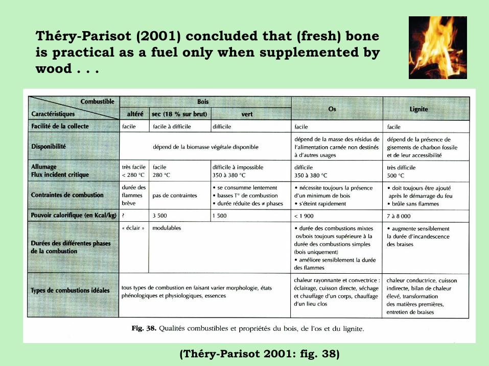
Théry-Parisot (2001) concluded that (fresh) bone
is practical as a fuel only when supplemented by
wood . . .
(Théry-Parisot 2001: fig. 38)

(Théry-Parisot et al. 2002: fig. 4)
3 hearths x 6 hours = 40 kg fresh bone

Beringian archaeological sites contain large
quantities of bone ash and some wood charcoal
—usually willow
BERELEKH Salix spp., Larix sp. 14 ka
SWAN POINT Salix spp. 13.5 ka
Populus/Salix group 13.5 ka
TULUAQ HILL Salix spp./Populus 13.1 ka
DRY CREEK Salix sp. 13 ka
MOOSE CREEK Salix spp. 13 ka
MESA Salix, Populus, Alnus 11.5 ka
SWAN POINT
WALKER ROAD
USHKI

Marquer et al. 2012: 117, fig. 6
Occupants of northern Eurasia during the last glacial
often used bone fuel, but also used wood as supplement,
as recently shown in new analysis of Mezhirich
(Ukraine) hearths (Marquer et al. 2012)

Yana sites
Pre-LGM settlement of Beringia

Pitulko et al. 2004
Pitulko et al. 2012
32–30 ka
Yana sites dated to ~32,000–30,000 cal BP
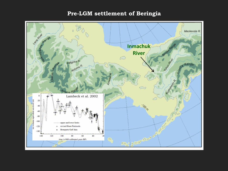
Inmachuk River
Pre-LGM settlement of Beringia
Lambeck et al. 2002
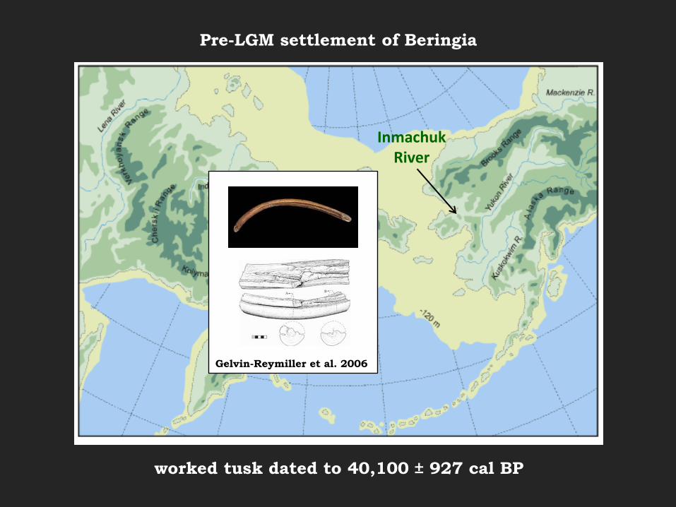
Inmachuk River
Gelvin-Reymiller et al. 2006
Pre-LGM settlement of Beringia
worked tusk dated to 40,100 ± 927 cal BP

abandonment of northern Eurasia during the LGM
Goebel 1999: 201
Molodova 5 (Ukraine)

Beringian population isolated in shrub tundra refugium?

Exploitation of adjoining “steppe-tundra” zones?

Dyuktai Cave
post-LGM reoccupation of Northern Eurasia (~17–15 ka)

Dyuktai Cave
post-LGM reoccupation of Northern Eurasia (~17 – 15 ka)

Lateglacial expansion out of central Beringia as shrub tundra spreads

North Alaska Range: shrub tundra at 13 ka
(Bigelow and Powers 2001: fig. 5)
DRY CREEK (470 m asl)
OCCUPIED AT 13 ka

TANANA BASIN
NENANA VALLEY

ARCHAEOLOGICAL STRATIGRAPHY
OF THE TANANA BASIN: 14-11 cal ka
CZ 4: 14-13 cal ka
CZ 3: 12.5-11 cal ka
HIATUS
(Holmes 2001)
(Holmes 2001)
Dyuktai Culture

LAYER VI: 12.4-11.9 cal ka
LAYER VII: 13.1-12.9 cal ka
(Goebel et al. 2003: fig.3)
ARCHAEOLOGICAL
STRATIGRAPHY OF
USHKI: 13.1-11.9 cal ka

NENANA: 13.2-12.9 cal ka
DENALI: 12.5-10 cal ka
ARCHAEOLOGICAL STRATIGRAPHY OF
THE NENANA VALLEY: 13.1-11 cal ka
(Pearson 1999) (Goebel et al. 1996)

PERIOD
NE ASIA: LENA
BASIN
WESTERN BERINGIA
CHUKOTKA/KOLYMA
BASIN, ETC.
CENTRAL BERINGIA
BERING LAND BRIDGE
EASTERN BERINGIA
(ALASKA/YUKON)
LATE GLACIAL
14,000-12,000 cal BP
DYUKTAI CULTURE
DYUKTAI CULTURE
USHKI LAYER VII
ABANDONED AFTER SEA
LEVEL RISE
NENANA COMPLEX
LATE GLACIAL
16,000-14,000 cal BP
DYUKTAI CULTURE
BERINGIAN TRADITION
DYUKTAI CULTURE
LAST GLACIAL
MAXIMUM
(30,000-16,000 cal
BP)
ABANDONED DURING
LGM
ABANDONED DURING
LGM
BERINGIAN TRADITION
(SHRUB TUNDRA
REFUGIUM)
ABANDONED DURING
LGM
INTERSTADIAL
(MIS 3)
(>30,000 cal BP)
EARLY UPPER
PALEOLITHIC
YANA SITE COMPLEX
YANA COMPLEX?
WORKED TUSK?