Embed Size (px)
Citation preview

FOREWORD
The campus of The University of Western Australia is one of the most beautiful in Australia. Good planning, design and construction has also created one of Perth s truly distinctive and admired architectural landmarks.
For all its beauty, the campus has the very functional purpose of providing an environment that facilitates learning, research and scholarship, as well as fostering the social, cultural and sporting experiences that are integral to the full university life .
Universities today face many challenges. Information technology is changing the way academics teach and students learn. More and more people are seeking knowledge and a higher education than ever before. This has brought new expectations about curriculum and course delivery. Those not enrolled at UWA, wish to visit and enjoy the campus and participate in the many events and entertainments.
This campus plan is the latest in a series, extending from the initial layout design of the Crawley site in 1915 and on to the creation of the campus since 1930. The plan seeks to retain the ambience, beauty and functionality of the campus, redress some design flaws that have crept in over the years and give scope for future development. The plan aims to provide clear guidance, while allowing flexibility and responsiveness to the complex and continual demands that are required of the site. The traditions of UWA are symbolised by the campus but it is not a museum trapped in time. A dynamic sense of tradition is involved.
The Campus Planning Review 2000 is the result of the dedicated efforts of my colleagues on the Review Committee, the staff of the Office of Facilities Management, Mr R.J. Ferguson (Consultant Architect) and Mr W.K.James (Consultant Landscape Architect). I thank them for their ideas and pragmatic approach which has created a very worthy successor to earlier versions of the campus plan . I look forward to the progressive implementation of this plan, which I am sure will consolidate and enhance the reputation of The University of Western Australia as an outstanding campus of international quality.
Professor Deryck M Schreuder Vice-Chancellor and President

CONTENTS INTRODUCTION 1 THE CAMPUS PLANNING REVIEW 2000 COMMITTEE 3 ISSUES ANALYSIS 4 The Campus 4 Traffic, Parking and Access 5 Environmental Qualities 6 Campus Expansion 6 BACKGROUND 7 THE UNIVERSITY OF WESTERN AUSTRALIA 8 INTERACTION WITH THE COMMUNITY 9 THE MAIN CAMPUS 13 THE EXTENDED CAMPUS 15 PLANNING HISTORY 17 Wilkinson Plan 1927 17
Stephenson Plan 1954 – 55 19 Stephenson Plan 1959 – 62 – 65 21 Bunbury Plan 1975 23 Campus Planning Review 1990 25 Development Plan 1996 – 1999 27 Development Between 1990 and 2000 29 Shenton Park Site 31
CHARACTERISTICS 33 Campus 1 – Northern Precinct Including Car Park 23 33
Campus 2 – Middle Precinct 35 Campus 3 – Southern Precinct 35 Campus 4 – Nedlands Site 37 Campus 5 – Park Avenue Site 39 College Precincts 1, 2 and 3 41 River Precincts 1 and 2 43 Subiaco Precincts 1, 2, 3 and 4 45
AUTHORITIES 47
Metropolitan Region Scheme 47 Local Authorities 49 Heritage and Conservation 51 Conservation Plan 51 Heritage Council of Western Australia 52 Listed Places 55

TRAFFIC, PARKING AND ACCESS 57
Traffic Movement 57 Campus Ring Road 57 Existing Parking 2000 59 Parking Options on Campus 61 Parking Options Adjacent to Campus 63 Types of Parking Facilities 63 Campus Service Roads 65 Access 66
PEDESTRIANS 69 BUILDINGS 70
Heights of Buildings 73
LANDSCAPE 75 SERVICES 77
Service Corridors 77 Chilled Water 77 Parkway 77 Cooper and Clark Streets 77
UNIVERSITY OWNED PROPERTIES ADJACENT TO THE CAMPUS 79 RECOMMENDATIONS 80 CAMPUS STRUCTURE - EXISTING 2000 82
OPTION 1 DEVELOPMENT EXPANDED CAMPUS 84 Campus Structure 84
Traffic, Parking and Access 86 Environmental Qualities 88 Building Sites 90
PREFERRED OPTION 1 DEVELOPMENT PLAN EXPANDED CAMPUS 91 OPTION 2 ALTERNATIVE DEVELOPMENT PLAN EXPANDED CAMPUS 94 OPTION 3 DEVELOPMENT WITHIN EXISTING BOUNDARIES 97 Campus Structure 97 Building Sites 99 Parking Facilities 101 Reclaimed Green Spaces 103 OPTION 3 DEVELOPMENT WITHIN EXISTING BOUNDARIES 104 NOTIONAL TOTAL DEVELOPMENT PLAN EXPANDED CAMPUS 106

REVIEW REPORT The structure of this report is based on the issues and topics as presented to and discussed by the Campus Planning Review 2000 Committee. Being a planning review, the report basically comprises illustrations with supporting text. The presentation of the report attempts to locate relevant text opposite relevant illustration and comparative illustration opposite comparative illustration. This has inevitably resulted in some repetition which may be less frustrating than searching through the report for matching illustrations and text.

1
INTRODUCTION The University of Western Australia is of great historical significance and is recognised as a regional asset. It enjoys a good public image because of its academic achievements, cultural contributions to the community and the physical qualities of its campus. As background to the Review process, the particular qualities of the campus, its place in the region and interaction with the general community are identified and the principles governing its physical development to this date are analysed. The layout of the campus, in terms of functional grouping of buildings, disposition of major green spaces and pedestrian, vehicular traffic and service systems, has followed the structure established by Professor Gordon Stephenson in 1955, based on Professor Leslie Wilkinson’s 1927 plan. Locating facilities for expanding disciplines in fully developed sections of the campus will become increasingly difficult without relocation or demolition and rebuilding. It is not possible to accurately predict the expansion or amalgamation requirements of all disciplines nor the timing of these requirements. It is remarkable that, after 70 years of continuous development, the University has not faltered in its dedication to achieving and maintaining a campus of outstanding physical qualities, especially as the campus is relatively small and is under constant pressure for new building sites and additional car parking facilities. This disciplined period of development has produced a strong building and landscape ethic, departure from which could impact on the integrity of the campus. If the campus is to enjoy at least another 70 years of successful development, all sections of the relatively small campus must be treated as uniquely precious. For instance – relocating the eight Tennis Courts in the north-east corner of the campus to a site off, but adjacent to, the campus would cost at least $5M on current land values alone. The same site area on campus must be worth at least double or treble that value because of its potential for accommodating teaching and research facilities. The campus must not be considered “free” land. It is desirable to maintain and enhance the unique qualities of the campus: • A well-defined, ordered but flexible planning structure. • An inner pedestrian precinct free from excessive vehicle penetration. • Landscaped courts within and between small scaled and highly contextual buildings. • An open campus which encourages interaction with the wider community. On-campus parking facilities have already exceeded the environmentally acceptable number recommended in all previous campus planning studies. The demand for additional facilities has not decreased. The University has pursued several alternative means of accessing the campus other than by private motor vehicles. The most promising of these is an efficient and convenient bus service. The success of this alternative will be limited if the economic viability of public transport is undermined by a continual increase of parking facilities on and adjacent to the campus.

2
Additional parking facilities, in whatever form, must have a negative impact on the campus and increase traffic movement pressures on neighbouring streets. To maintain and enhance the environmental qualities of the campus and provide for future development, however modest, it is inevitable that the campus will expand, in some form, towards Broadway. To facilitate this expansion, the University has purchased, at some considerable cost, many properties between the campus and Broadway when these properties have become available and have been affordable. Appropriate zoning and control mechanisms in this area are required to support expansion and provide opportunities for the development of University partnered, collaborative ventures and community orientated facilities. Concurrent with the commencement of this Review 2000, the City of Subiaco advertised its Draft Town Planning Scheme No. 4 including its proposed zoning and development controls for the area west of the campus to Broadway. The development potential of this area of land will influence possible expansion of the campus in this direction and, therefore, appropriate planning solutions for the main campus. For the purpose of guiding the Review, a Campus Planning Review 2000 Committee was formed and chaired by Professor Deryck Schreuder, Vice-Chancellor and President. The last formal Campus Planning Review was prepared in 1990, followed by a Nedlands Campus Proposed Redevelopment Report in 1991 after the acquisition of the Nedlands Campus of the Western Australian College of Advanced Education by the University. Both the 1990 Review and 1991 Report were prepared by R.J. Ferguson & Associates, Architects. A Campus Landscape Review was prepared in 1992 by William K. James, Landscape Architect. A Campus Development Plan was prepared in 1996, and continuously updated by Frank Roberts, Manager Planning and Design, Office of Facilities Management. The above Reviews, Report and Development Plan, were made available to the Review 2000 Committee along with a paper “The Characteristics and Future Directions of The University of Western Australia” – itself taken from the University’s Strategic Plan, the Operational Priorities Plan 1999-2000, Achieving International Excellence and various institutional management plans.
3
THE CAMPUS PLANNING REVIEW 2000 COMMITTEE The Committee formed to guide the Review 2000 was chaired by Professor Deryck Schreuder, Vice-Chancellor and President. The Committee met regularly between March and December 1999 and comprised: Mr. K. Abercromby Senate Member Justice C. Wheeler Senate Member Professor A. Robson Deputy Vice-Chancellor and Provost Professor C. MacLeod Chair Academic Board Dr J. Gregory Academic Staff Representative Mr. H. Schubert President WA Chapter, Royal Australian Institute of Architects Mr. M.L. Griffith Executive Director, Finance & Resources Ms. L. Key General Staff Representative Mr. C Smith Postgraduate Student Representative Ms. E. Tomkinson Undergraduate Student Representative By invitation: Mr R. J. Ferguson Consultant Architect Mr W.K. James Consultant Landscape Architect Mr F. Roberts Manager, Planning and Design Secretary: Mr. W. Browne, Manager, Administration
4
ISSUES ANALYSIS As a guide for the Review process, an issues analysis was undertaken to identify the strengths and weaknesses of the campus and the opportunities for and threats to its appropriate development in the foreseeable future. In response to the analysis, the Campus Planning Review 2000 Committee identified the following characteristics and issues: THE CAMPUS • For the purposes of this Review, the “main campus” includes the Nedlands and Park Avenue sites
and Car Park 23. • The University operates on a single campus with outreach facilities and is expected to continue to
do so. • The area of the campus is relatively small compared to that of the other three public universities in
the State. Long term continued development within the established planning structure and landscaped character of the campus will be limited unless the campus is expanded.
• Its particular location adjacent to the Swan River and Kings Park constrains expansion of the
campus except to the west. • The campus enjoys a disciplined pedestrian and green space system in the northern and middle
precincts but not in the southern precinct because of the constriction of the campus at Myers Street.
• There is an over concentration of public accessible facilities – performing arts venues - in the
northern precinct creating visitor congestion at peak times. The campus would benefit from a wider dispersal of such facilities.
• Cultural and community use of the campus in the evenings and weekends is likely to increase,
especially if more student residential accommodation is created. • A need was seen for reinforced communications and relationships with the wider community. • Collaborative ventures with Government, industry and other institutions may require sites for the
development of specialised “public interface” facilities. • Pedestrian connection between the Nedlands and Park Avenue sites and the main body of the
campus is tenuous because of the Broadway, Stirling Highway and Hackett Drive, Mounts Bay Road intersections. The appropriate use of these sites, especially the Park Avenue site, for undergraduate facilities is limited.
• A range of housing types – other than halls of residence – should be investigated to encourage
more students to live closer to the campus. • The Winthrop Entrance should be maintained as the main campus entrance. Other prominent
entrances are required on the eastern, southern and western boundaries.

5
• A site in the extreme south east corner of the campus with views to the south over Melville Waters
was identified as a very prestigious site worthy of a prominent group of buildings with the qualities, presence and community interface of the Hackett Memorial Buildings.
• Views to, and the relationship of the campus with, the Swan River should be maintained and
enhanced. • The University should maintain some influence over development on the river foreshore. • Integration of the properties west of Fairway and Parkway with the campus, at least through the
extension of the campus landscaped spaces, is desirable both for the University and the community.
• The indigenous heritage of the campus site should be acknowledged and linked to a Campus
Conservation Plan. • Heritage Council listing of “places” on the campus may impose controls on the redevelopment or
demolition of facilities, which could constrain the appropriate use of these places for University purposes.
TRAFFIC, PARKING AND ACCESS • Limited means of accessing the campus, other than by private vehicles, causes traffic congestion
on neighbourhood streets and excessive demands for parking facilities on and adjacent to the campus.
• If the landscaped qualities of the campus are to be maintained, the University cannot provide
parking facilities for all staff, students and visitors wishing to park on campus. • The acclaimed environmental qualities of the campus are under threat by increasing car park
facilities at the expense of green spaces and building sites. • Parking facilities on and adjacent to the campus should be limited to around their present capacity
and alternative means of accessing the campus should be actively encouraged. • There is a need to minimise the penetration of vehicles into the inner pedestrian precincts of the
campus. • The lack of a “backdoor” to many buildings causes service vehicles to penetrate the pedestrian
system. • The campus internal ring road is incomplete. Provision at least should be maintained for its
completion should the future so require. • The incomplete ring road and one-way traffic on the northern ring road is forcing campus vehicles
on to the external road system to re-enter the campus at another place. • The location of some exits is causing congestion on the ring road at peak times. • The provision of parking facilities adjacent to the campus, such as Car Park 21 at Edward Street,
should be explored to make use of the change in ground levels and to diminish the impact of car parks on the environment of the campus.
• On campus multi-storey parking structures are not favoured unless they can be successfully
integrated into buildings. The significant additional costs of undercroft or underground parking facilities are acknowledged.

6
ENVIRONMENTAL QUALITIES • The campus ethos is signalled by the planning structure and the quality of the buildings and
landscape in the northern precinct. • There is an imbalance between the character and quality of the northern, middle and southern
precincts of the campus. • In terms of architecture and landscape, sections of the western flank of the campus at Fairway are
not of the same standard as the eastern flank at Hackett Drive. • It is desirable to maintain and enhance the planning structure and qualities of the campus
architecture and landscape especially in the middle and southern precincts. • If the established character of the campus is to be maintained, sites for future facilities will
become increasingly rare and cannot be utilised for parking or exotic uses. University/partnered and collaborative venture facilities should be located off, but adjacent to, the main campus.
• Security for pedestrians on campus should be maximised through the location of car parks,
building design, landscape, lighting, emergency communication systems and any other means. • Where taller buildings (say six to eight storeys) are required they should be confined to the higher
western flank of the campus if possible. However, a continuous high wall of buildings on Fairway is to be avoided.
• Maximum flexibility is required of campus buildings to allow for growth and contractions of
departments and changes in discipline groupings. CAMPUS EXPANSION • Despite technological advances in communication and the advent of the, so called, “virtual
campus”, students value social intercourse on campus. A reduction in the need for buildings and other on campus facilities is not anticipated.
• If the green spaces are to be maintained, the expansion of some disciplines in fully developed
sections of the campus is now limited to relocation or the demolition of low-rise buildings and rebuilding high rise.
• To protect the established qualities of the campus and to provide for expansion of facilities,
especially those interfacing with the general community, expansion of the campus to the west, in some form, is inevitable.
• To facilitate this expansion, the University should continue to acquire properties off campus at
least in selected areas. • Proposals in the Draft Subiaco Town Planning Scheme No. 4 being processed concurrent with the
preparation of this Review do not support the requirements of University expansion. • Amendments to the Subiaco Town Planning Scheme No. 4 should be pursued by working with the
City of Subiaco and the Western Australian Planning Commission to secure zoning and other control mechanisms appropriate to the development of University/community interface facilities.

7
BACKGROUND Topics pursued by the Review Committee as background to achieving a Development Plan for 2000 and beyond.

8
THE UNIVERSITY OF WESTERN AUSTRALIA The University of Western Australia is one of five universities, four public and one private, serving Western Australia. As part of the Unified National System of universities created under the Dawkins higher education reforms of 1987, it is one of the 38 public higher education institutions in Australia, together with another two private universities. In the context of the UNS, UWA can be regarded as a comprehensive but medium sized university. It is one of eight “research-intensive” universities within the system under the title of the “Group of Eight”. The University’s primary characteristics include: • high quality, as the pervading principle underpinning all activities; • comprehensive, with a broad mix of arts, sciences and professional studies; • selectivity, in support of areas of particular strength, importance and opportunity; • research intensive, with a strong teaching and research nexus; • internally focused, in terms of content and standards; • technology innovative, in terms of the learning environment; • a community resource, with a diversified resource support base. In the absence of major structural change, or significant population growth in Western Australia, it is likely the University will pursue modest, rather than rapid growth. The University aims to seek growth in student load and budget to enable a high quality comprehensive base to be sustained, while generating resources for directing to the development of a limited number of selected areas of particula r strategic opportunity. The growth target for enrolment over the next decade is up to 18,000, with a mix of 12,500 undergraduate, 3,300 postgraduate research and 2,200 postgraduate coursework. It is intended that the growth in postgraduate coursework should emphasise international students, particularly off-shore, and professional education, as part of a refocussing and improvement of the postgraduate program mix. The use of innovative technology and methodology – from biotechnology to the technology of flexible delivery -–is to be fully integrated into all University programs in such a way as to enhance the University’s standing as a high quality, internationally competitive institution. The University has two major offshore operations in Singapore and Hong Kong; over 50 formal agreements in place with other universities, and approaching 30 student exchange programs with participating universities in Asia, Europe and North America. The University does not seek to move from a single campus establishment, but will explore opportunities to develop multi-delivery points across the State.

9
INTERACTION WITH THE COMMUNITY The University interacts with the general community in a variety of ways ranging from casual use of its facilities such as garden courts for wedding photographs and lecture theatres for single events to Festival activities lasting for a period of three to four weeks regularly each year. Many activities bring concentrated numbers of extra people onto the campus at times in conflict with student and staff usage of campus facilities. UNIVERSITY EXTENSION University Extension is involved with community education programs including the Summer School, lectures and courses relevant to more than one department or faculty. The Summer School Established by the Adult Education Board as a service to encourage the general community to participate in concentrated education programs, the Summer School has developed into a program operated annually for two weeks in January, each program having a different theme. Community Education Courses Extension offers a number of community education courses running throughout the year with lectures generally held during evenings. Day courses can infringe on staff and student use of campus facilities. The University of the Third Age Non-award courses in the form of monthly lectures held throughout the year are available to retired and other aged persons. CONTINUING EDUCATION COURSES Various individual departments organise continuing education lectures for professionals, business people and others in the community. LECTURE SERIES
Lectures by prominent persons on topical subjects are organised throughout the year and are available to the general public.
UNIVERSITY OF WESTERN AUSTRALIA PRESS
The Press holds regular book launches, panel discussions and lectures on campus. PERTH INTERNATIONAL ARTS FESTIVAL The Festival was founded in 1953 as a means of providing evening entertainment for participants in the Summer School program. Ties with the Summer School have been broken, but the link with the University remains. The Film Festival runs from late November until early April, and main Festival events from late January to late February each year. The Film Festival overlaps the commencement of the academic year, but most events occur in the evening outside normal University hours.
The growth of the Festival has necessitated the more frequent use of off campus venues. University facilities, such as the Somerville Auditorium, Octagon, Dolphin and New Fortune Theatres are in continual use throughout the Festival period. The Sunken Garden and Winthrop Hall are also used on occasions.

10
DEPARTMENT OF HUMAN MOVEMENT AND EXERCISE SCIENCE Programs provided by the Department involving the general public and in some instances specific members of the public include “Unigym” and “Uniswim”, a Corporate Program, the GAIT Program for doctors and patients and the sale of a number of sport related publications and videos on subjects such as aerobics, sailing, badminton and cricket. The Uniswim program includes learning to swim classes for all ages, rehabilitation classes and the use of the swimming pools by the general public attracting approximately 1,000 persons a week onto the campus. The Unigym program is a remedial physical education program for children aged four to twelve years. A number of community service workers and practice students from other institutions participate in the program.
SPORT AND RECREATION FACILITIES Indoor sports halls, outdoor courts, grass fields and an Olympic standard synthetic hockey pitch are made available for regular school use, state sporting competitions and other community events. Challenge Stadium, the state sport centre, is located at the UWA Sports Park and services the local community as well as hosting national and international sporting events. Many of the Western Australian Institute of Sports athletes train at UWA Sports Park. PROGRAMS
The general community participates in a wide range of sport, fitness and recreation activities and competitions including: Recreate A program to provide comprehensive information on all sporting and recreation activities on and off campus. Approximately 40% of participants are from the general public.
Uni Sport for Kids Sports based programs available to primary school children during school holidays. Campus Challenge A live-in orientation camp to introduce high school students to university activities including sport and culture. Sports Competitions Adult fun competitions and sports tournaments and events are available to the general community as well as school sports based programs such as rowing. Fitness Centre Undergraduate and graduate students are employed as instructors to provide a comprehensive range of fitness training opportunities to the University and general community for 50 weeks of the year. SPORTS CLUBS The University has 30 affiliated sports clubs with over 2,500 members, approximately 30% of which are from the general community and 30% alumni.


underpass
underpass
crosswalk
crosswalk
unde
rpas
s
MatildaBay
MelvilleWater
FAIR
WA
Y
BR
OA
DW
AY
CLARK ST
EDWARD ST
COOPER ST
FAIR
WA
Y
BR
OA
DW
AY
STIRLING HIGHWAY
CLIFTO
N ST
GORDON ST
KA
NIM
BLA RD
KARELLA ST
TA
RE
ENA
ST
PARK RD
HA
MPD
EN
RD
LEU
RA
ST
HA
MPD
EN
RD
THE AVENUE
PRINCESS RD
EVERETT ST
CAPORN ST
COOK ST
MYERS ST
PAR K
WA
Y
MOUNTS BAY ROAD
CRA
WLE
YA
VE
NU
E
DRIVEANDREW'S
SAW
PRO
MEN
AD
E
GILLET T PRO
MEN
AD
E
IRW
IN ST
HACKETT
DRIVE
HA
CK
ETT
DR
IVE
PARK AVENUE
POOLEAV
WIN
TH
RO
P AV
EN
UE
MEG
ALO
NG
RD
outdoorlaboratory
TaxonomicGarden
PrescottCourt
tenniscourts
OakLawn
JamesOval
SunkenGdn Whelan
Court LawrenceJacksonCourt
SomervilleAuditorium
RileyOval
GreatCourt
WhitfeldCourt
CP23
PARKAVENUE
SITE
NEDLANDSSITE
Hampden Ent
Gordon Ent
Clifton Ent
Fairway Ent 2
Fairway Ent 1
Fairway Ent 3
Fairway Ent 4
Winthrop Ent
Hackett Ent 1
Hackett Ent 2
Hackett Ent 4
Hackett Ent 3
Parkway Ent 1
Parkway Ent 2
Parkway Ent 4
Parkway Ent 3
THE MAIN CAMPUS12
NORTH

13
THE MAIN CAMPUS When referring to “the campus”, early planning studies would not have included the Nedlands site, and it is not clear whether more recent studies have included the Park Avenue site, or the Car Park 23 site. For the purposes of this Review the main campus consists of: • A 46.7367 hectare area bounded by Mounts Bay Road, Hackett Drive, Parkway, Myers Street,
Fairway and Stirling Highway 38.6321 hectares of which was leased from the Crown on 3 March 1920 for a period of 999 years.
• An additional area of 0.7382 hectares, which was added to the 999 year lease area after a
realignment of Hackett Drive at Mounts Bay Road and which is now used as Car Park 23. • The 2.2915 hectare Park Avenue site bounded by Park Avenue, Crawley Avenue, Mounts Bay
Road and St George’s College. Owned by the University on freehold title. • The 3.5367 hectare Nedlands site bounded by Gordon Street, Hampden Road, Stirling Highway
and Clifton Street. Owned by the University on freehold title. These four sites total some 53.3031 hectares in area. The equivalent main campus areas of the other three public universities are somewhat larger: Edith Cowan University 136 hectares (five campuses) Curtin University of Technology 116 hectares Murdoch University 250 hectares The College sites north of Stirling Highway and Mounts Bay Road are owned by the various Colleges but with reversion clauses – should the sites cease to be used for college purposes the ownership of the sites reverts to the University. The ownership of the buildings on the sites would require negotiation. Kingswood College 2.0437 hectares St. Columba College Inc. 2.04 hectares St. Catherine’s College Inc. 2.02 hectares St. Thomas More College Inc. 2.2187 hectares (R.C. Bishop of Perth) St. George’s College Inc. 2.39 hectares Currie Hall 2.2812 hectares owned by the University. Two sites totalling 0.9581 hectares in area either side of Winthrop Avenue between St. Catherine’s College and Currie Hall at the junction of Stirling Highway and Mounts Bay Road are owned by the University.


15
THE EXTENDED CAMPUS The extended campus facilities include: A significant presence in: QEII Medical Centre Fremantle Hospital Princess Margaret Hospital King Edward Memorial Hospital Medical Research Foundation at Royal Perth Hospital Space in: Hollywood Private Hospital Graylands Hospital St John of God Hospital (Subiaco) WA Centre for Oral Health (WACOH) Rented office space in Stirling Highway The 674 hectare Allandale farm at Wundowie used by Agriculture for research purposes. The 180 hectare Harry Waring Marsupial Research Station at Jandakot. Irrigated Summer Crops Research Centre at Waroona. The 62 hectare Shenton Park site, 23 hectares of which is planned for residential development, 8.5 hectares for bushland and 1.8 hectares for public open space. The remaining 28.7 hectares will be retained for University research purposes. The 50 hectare UWA Sports Park (McGillivray) – University and community sporting facilities. McGillivray workshops and stores. Albany Centre – undergraduate and postgraduate teaching. Geraldton Centre for Rural Health – being established. Rottnest Island – use of a house and facilities in the central lighthouse. Currie Hall – residential Claremont Community Health Centre Watermans Bay Marine Biology Laboratory University Boat Club leased from CALM


17
PLANNING HISTORY Early in 1914, in order to protect public access to the river, the Government resumed the 61.5 hectare riverside Shenton farm. Part was made available to the University and part retained for use as a public reserve.
Later in the same year, the Department of Mining and Engineering moved from the University’s temporary home in Irwin Street, in the City of Perth, to occupy the two storey Shenton homestead.
In 1915 the University held an international competition for “the best suggestions or plan for laying out the Crawley site for University purposes”.
The selected design submitted by a Melbourne architect Harold Desbrowe-Annear was based on a formal system of axes radiating from a point at the intersection of Fairway with the Perth-Fremantle Road (Stirling Highway) and an extension of Ferdinand Street (Winthrop Avenue). Residential colleges were located on the north side of the Perth-Fremantle Road. WILKINSON PLAN 1927 Desbrowe-Annear’s plan was to suffer criticism and was redesigned by the Public Works Department in later years because of the inflexible layout and concentration of buildings in the north-west corner of the campus.
In 1926, when the benefits of the John Winthrop Hackett bequest become known and provided the opportunity for the University to commence development with a group of prominent buildings, Leslie Wilkinson (Professor of Architecture at Sydney University) was invited to prepare a layout plan for the Crawley site. A condition of the Hackett bequest was that the designers of the group of ceremonial buildings be selected by means of an open architectural competition. Entries were invited from Australasia, Britain and America for the design of these buildings in accordance with a plan prepared by Wilkinson. The competition was won by Melbourne architects Rodney H. Alsop and Conrad H. Sayce in 1927. The 1926 Wilkinson plan, revised in 1927, located the competition buildings (Hackett Memorial Buildings) at the head of a strong north-south axis, including a Court of Honour (Whitfeld Court), a Great Court, an object which became the site of the Reid Library, and an oval (James Oval). Desbrowe-Annear’s location of the residential colleges was retained, as were two diagonal landscaped axes. Wilkinson’s plan was notable for the congestion of buildings on the higher ground in the north-west corner of the campus. The tight monolithic layout of the main body of buildings denied flexibility and made expansion of departments difficult.
It has been assumed that the Desbrowe-Annear plan could have served a student population of around 2000 and the Wilkinson plan around 3000.
When it was realised that the campus population would inevitably exceed these numbers, the constraints of the Wilkinson plan became apparent.
Several ad hoc modifications, in terms of siting buildings, were made without reference to Wilkinson and after the completion of the Hackett Memorial Buildings in 1930-31, and Rodney Alsop’s death in 1932, building work was undertaken by a variety of architects including those in the Public Works Department.


19
The outbreak of war in Europe in 1939 brought the physical development of the campus to a virtual standstill until hostilities spread to the Pacific region in 1941, when the Allied Works Council erected temporary buildings for the Navy on, and adjacent to, the campus. Several of these lightweight structures were retained and utilised by the University after the War. In 1946, the Public Works Department erected some new timber framed buildings to the west of Shenton House for use by the School of Engineering. This “Arab Village”, as it was called, was progressively demolished in the early 1960’s. By 1953, the Public Works Department had made extensions to some buildings and commenced designs for a series of others. STEPHENSON PLAN 1954 – 55 Because of the deficiencies of the Wilkinson plan and potential ad hoc siting of buildings in the absence of an appropriate development plan, Gordon Stephenson (Professor of Civic Design at the University of Liverpool and later planning consultant to the Western Australian Government) was invited to prepare a campus plan adequate for a predicted student population of 8000 by the late 1980s. Stephenson’s 1954 plan, refined in 1955, retained the basic spinal structure of the Wilkinson plan, but also dispersed building sites over the campus, creating a simple, ordered but flexible and highly aesthetic arrangement of buildings and spaces. The principles of the plan were that departments were located in functional groups; vehicles were excluded from the inner campus green spaces but did penetrate to the pedestrian ways and cut across the campus south of Winthrop Hall and south of the site for Chemistry. Buildings were shown to partially enclose landscaped courtyards. Car parks were restricted to the boundaries of the campus. The plan maintained Desbrowe-Annear’s location of residential colleges north of Stirling Highway and Mounts Bay Road and Wilkinson’s north-east Alley as Battye Avenue. The main library was relocated from the Hackett buildings to a central site between Great Court and James Oval. Myers Street was shown crossing the campus to link with Hackett Drive. The plan showed parking for 1000 vehicles. Stephenson recommended against the forced continuation of the Alsop-Sayce style of architecture. However, he was a great advocate of future buildings being in context with the original development and that all buildings should be “university” in character.

21
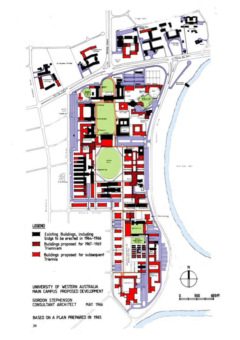
In 1958 the Principal Architect of the Public Works Department and Marshall Clifton (a Perth architect) were invited to collaborate in the preparation of comprehensive designs for the new Chemistry, Physics, Library and Arts buildings. In pursuing these designs, the Principal Architect took it upon himself to “review” the Stephenson plan which he considered inadequate to meet building areas required for the anticipated student population. The PWD proposal relocated James Oval to be adjacent to Hackett Drive destroying the north-south axis and establishing a competing strong east-west axis. The Library was shown on a site in the centre of the present Great Court. The plan was not well received by the University and Stephenson was invited to review his 1954-55 plan in light of the proposals made by the Principal Architect and Clifton. STEPHENSON PLAN 1959-62-65 Stephenson’s 1959 plan maintained the structure of the 1954-55 plan but intensified the site coverage of buildings, almost to the exclusion of large landscaped spaces, in order to meet estimates of 148,000 square metres of building area required to accommodate predicted populations in 1967. Stephenson reiterated the basic planning principles of the 1954-55 plan, adding that it was undesirable to make provision in buildings for undergraduate classes beyond the third level but, if necessary, space in upper levels of six or eight storey buildings could accommodate such facilities as staff offices and research laboratories. When in Perth to present the 1959 plan, Stephenson accepted an offer to return as Consultant Architect to the University and took up that full-time appointment in 1960 by which time the designs of University House and the Engineering, Chemistry, Biochemistry and Physics buildings had been committed. Stephenson supported the use of cream (buff) brick for the Physics and other buildings on the west flank of the Great Court. The structure of the inner “vehicle free” pedestrian precinct was established in the 1959 plan. Stephenson reviewed the campus plan in 1962, and again in 1965. That last plan showed even more intense development of the campus than the 1959 and 1962 versions. The 1959 plan made provision for 1,800 parked vehicles. The Myers Street cross-campus link was deleted from these plans, which also predicted the loss of the landscaped character of the campus by excessive building. The 1965 plan showed the campus ring road complete, except at Parkway, and made provision for 2,000 parked vehicles which was recommended as a maximum number. The 1965 plan was not endorsed by the Senate.


23
Stephenson resigned his position as Consultant Architect in 1969. He was succeeded by Arthur Bunbury (a Melbourne architect) who arrived at the University late in 1966 and who took the title “University Architect”. A large building programme had been commenced before Bunbury’s involvement and included two pedestrian underpasses connecting the main campus with Currie Hall and St. Catherine’s College. The underpasses were constructed in 1966 and opened in 1970. In siting other buildings, Bunbury followed the basic intent of the Stephenson plans with some variations in particular locations. BUNBURY PLAN 1975 In 1973, as “University Architect”, Bunbury prepared an “Interim Report on Campus Planning with Special Reference to Possible Developments in the 1976-78 Triennium”. The report also made recommendations on the classification of Permanent Green Reserves. In 1975, Bunbury’s “Report on Campus Planning” superseded the interim report and remained the last formal review of the campus plan until the “Campus Planning Review 1990” prepared by R.J. Ferguson & Associates. The 1975 plan maintained the planning principles of the Stephenson plans but relaxed the density of buildings shown on these plans and reinstated some of the major green spaces which grace the campus today. The cross-campus leg of Myers Street had been closed in 1971-72, but the bitumen surface remained in use as a car park. Bunbury instigated its removal, so the landscaping of what became Prescott Court could be completed. At the time of the 1975 report, the realignment of Hackett Drive was in the design stage. The campus was cut by Hackett Drive, and Bunbury was instrumental (between 1979 and 1981) in achieving a realignment which resulted in the campus being unified and Hackett Drive being continuous with Princess Road. As a result of the new intersection of Parkway with the Avenue, Princess Road and Hackett Drive, Parkway was closed in 1977 by the Subiaco City Council causing some traffic exit problems for the campus. Later in 1975, Bunbury prepared a document entitled “Recommendations to the Senate on Parking and Traffic”, which predicted a need for 4,000 vehicle spaces for a planned maximum population of 12,000 students. 2,000 of these spaces were to be on or immediately adjacent to the campus and the remainder off-campus in remote parks possibly served by shuttle buses. Bunbury recommended the continued acquisition of properties off campus between Fairway Parkway and Broadway for the purpose of expansion of the campus with University/community related projects. This led to the construction of the Edward Street Car Park 21 and buildings for CSIRO and TISC between Fairway and Broadway completed in 1990. The 1975 plan showed an extended but incomplete ring road. It retained the 1959 pedestrian system in the northern and middle campus but not the planning structure of the southern campus, possibly because of uncertainty of the final location of Hackett Drive in the south-east corner.

25
Bunbury retired from the position of University Architect late in 1985, and since that date the University has been taking planning advice from Consultant Architect, R. J. Ferguson. A “Traffic and Parking Strategy”, one of several studies undertaken to help resolve a growing car parking problem on and off campus, was completed in 1986. Among other findings, the Strategy recommended: that areas between Fairway and Broadway north of Myers Street be incorporated into the long-term development plan for the campus and that these areas be seen as mixed-use zones for University, business and commercial activity. These areas were identified as being strategically located for the provision of both “backlog” and future parking facilities.
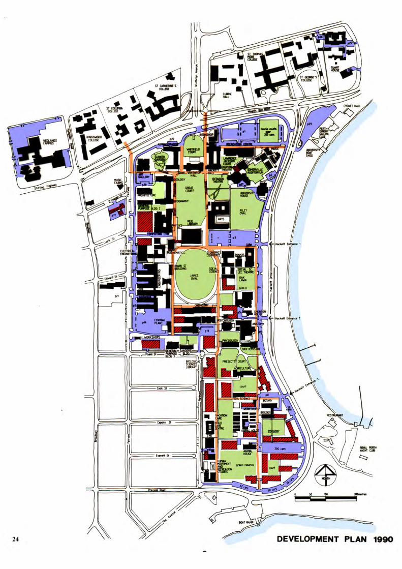
The Strategy recommended that any additional on-campus car parks be located on the western flank of the campus. The first undercroft car park was completed in 1989 under the Human Movement Gymnasium. The first basement car park under the Lawrence Wilson Art Gallery and the first decked car park adjacent to the campus between Broadway and Fairway south of Edward Street were both completed in 1990. As part of its expansion strategy, the University acquired the 3.5-hectare Nedlands campus of the Western Australian College of Advanced Education. After refurbishment, the facilities on the Nedlands site became available to the University in 1993. CAMPUS PLANNING REVIEW 1990 The 1990 Review, prepared by R.J. Ferguson & Associates, recorded the background to the development of the campus structure and the findings of the many studies undertaken in pursuit of preventative solutions to the dangers of excessive building, together with the over-supply of car parks to the acclaimed environmental qualities of the campus. The Review supported the basic planning principles of the 1955 and 1975 plans, but also noted that the recommended maximum of 2000 ground level, on-campus, parking spaces had been exceeded by 520 spaces for a student population of around 10,500. In support of the enhancement of the landscaped qualities of the campus, the Review proposed relocating certain facilities to the Shenton Park campus, including a 2000 space car park served by a campus shuttle bus. It supported redevelopment of the Nedlands site to accommodate disciplines relocated from the Crawley site and also the need for a grade separated link to facilitate interaction between the two sites. The Review recommended the continued acquisition of properties between Fairway, Parkway and Broadway for use by the University in some form. In an attempt to avoid the possible ad hoc location of facilities at the expense of the landscape, the Review was specific in its finite location of building extensions and new buildings. It expanded the pedestrian and green space system in the southern campus. It was also specific in the retention of cross-campus views to the river, the provision of landscaped entrances into the western campus and the choice of hard landscaping materials, furniture and signage. It promoted the retention of space on the perimeter of the campus to permit the construction of a continuous internal ring road except for the section adjacent to Parkway. It addressed the problems of the one-way section of the northern ring road and the relocation of the tennis courts exit at Hackett Drive to increase vehicle queuing distances. The site in the south-east corner of the campus was identified as a prime location for a prominent group of buildings at a southern main entrance to the campus.

27
DEVELOPMENT PLAN 1996 - 1999 The UWA Crawley Campus Development Plan 1996 was prepared by Frank Roberts, Manager Planning and Design, Office of Facilities Management. The 1996 Development Plan has been continuously updated. The Development Plan recorded permanent and temporary buildings and indicated preferred locations of future buildings. The Commentary on the Development Plan was specific in the number of levels and floor areas of each potential future building. It also commented on individual formal landscaped spaces both existing and future, car parking facilities associated with new buildings and green spaces, services including provisions for chilled water storage and traffic movement both on the campus ring road and on external roads. The Development Plan assumed that the student population would maximise at 16,500 EFTSU by 2010 to 2015; that the Crawley campus would not expand beyond its present boundaries and expansion after 2010 – 2015 would be contained on a second campus at the University’s Shenton Park site. The 1996 – 1999 Development Plan did not depart from the structure set by the Stephenson plans and their planning philosophy, nor the findings of the Campus Planning Review 1990, except on the issue of expansion of the Crawley campus.

underpass
underpass
crosswalk
crosswalk
unde
rpas
s
MatildaBay
MelvilleWater
FAI R
WA
Y
BR
OA
DW
AY
CLARK ST
EDWARD ST
COOPER ST
F AIRW
AY
BR
OA
DW
AY
STIRLING HIGHWAY
CLIFTO
N ST
GORDON ST
KA
NIM
BLA
RD
KARELLA ST
TAR
EE
NA
ST
PARK RD
HA
MP D
EN
RD
LEU
RA
ST
HA
MPD
EN R
D
THE AVENUE
PRINCESS RD
EVERETT ST
CAPORN ST
COOK ST
MYERS ST
PARK
WA
Y
MOUNTS BAY ROAD
CRA
WLE
YA
VE
NU
E
DRIVEANDREW'S
SAW
PRO
ME N
AD
E
GILLETT PR
OM
ENA
DE
IRW
IN ST
HACK
ETT
DRIV
E
HA
CK
ETT
DR
IVE
PARK AVENUE
POOLEAV
WIN
TH
RO
P AV
EN
UE
MEG
ALO
NG
RD
outdoorlaboratory
TaxonomicGarden
PrescottCourt
tenniscourts
OakLawn
JamesOval
SunkenGdn Whelan
Court LawrenceJacksonCourt
SomervilleAuditorium
RileyOval
GreatCourt
WhitfeldCourt
Hampden Ent
Gordon Ent
Clifton Ent
Fairway Ent 2
Fairway Ent 1
Fairway Ent 3
Fairway Ent 4
Winthrop Ent
Hackett Ent 1
Hackett Ent 2
Hackett Ent 4
Hackett Ent 3
Parkway Ent 1
Parkway Ent 2
Parkway Ent 4
Parkway Ent 3
CRAWLEY CAMPUSDEVELOPMENT 1990 -2000
28
NORTH
LEGEND
ROADS & CARPARKS
NEW BUILDINGSSINCE 1990
PROPOSEDDEVELOPMENTS

29
DEVELOPMENT BETWEEN 1990 AND 2000 In the ten years between the completion of the Campus Planning Review 1990 and this Review 2000, an additional thirteen new buildings were constructed on the main campus either as free standing structures or structures linked to existing buildings. Some of these buildings replaced existing structures, but the majority were located at the expense of open landscaped spaces. In this period, many other buildings, or parts of buildings were refurbished, some with vertical expansion. Five other sites were committed for new buildings, one at the expense of a major car park, one at the expense of a major green space and another at the expense of an existing building. The location of new buildings and extensions to existing buildings was in general accord with the 1990 Development Plan and the 1991 Nedlands Site Redevelopment Plan. The ring road and car park system changed little. Some car parks were remodelled to accommodate new buildings. It was noted that campus and service vehicles had increasingly penetrated the inner pedestrian system. In 1990, parking facilities available to the University on and immediately adjacent to the campus, totalled 3,707 spaces, excluding those on and adjacent to the Nedlands site. In 2000, equivalent parking facilities total 4,236 spaces, including those on and adjacent to the Nedlands site. What Stephenson and Bunbury referred to as “the campus” would have excluded the Nedlands and Park Avenue sites when recommending a maximum of 2000 vehicle spaces. That campus accommodated 2,519 vehicles in 1990 and, at the time of this Review, accommodates 2,499 vehicles. Particular areas of the campus have now been so developed that expansion of some facilities can only be achieved by relocation or vertical extension. Further pressure will be placed on the open spaces of the campus and, therefore, on the importance of securing properties off campus for future expansion. Limited funding may constrain University building development in the next ten years, but potential partnership arrangements between the University, industry and other bodies could create a demand for particular sites to locate such partnership facilities. In 1990, the student population totalled 11,100 and staff 2,200, which, by 1999, had grown to 14,500 and 2,300 respectively. (Note: approximately 10% of these students and staff were located at places other than on the main campus e.g. at hospitals.)


31
SHENTON PARK SITE In 1987 the University initiated a study to establish the development potential of its 62 hectare site south of Underwood Avenue, between Brockway Road and Selby Street, three kilometres north of the Crawley campus. At the time of the study, 21 hectares at the western section of the site was used by the University’s Faculty of Agriculture as a research station, approximately 3.7 hectares was leased to the Water Corporation. The University’s Department of Civil and Environmental Engineering occupied approximately 4 hectares of bushland, 3,500 square metres of which was developed, the Department of Botany occupied 4 hectares and Animal Services 5 hectares as research stations. Approximately 24 hectares of the site was under natural bushland. The initial study was based on the development of a research-based campus of some 3,000 to 4,000 population, and a “business park”. A more detailed plan prepared in 1990 identified five uses for the site: Administration, Teaching, Research, Business and Graduate Student Housing. The plan retained the existing Agriculture and Engineering research areas and showed a 2,500 space car park located in the south-west corner of the site as a buffer against the adjacent Sewage Treatment Works. It was proposed that a shuttle bus system would link the car park to the Crawley campus. The creation of this research campus and parking station was not pursued. In 1998, after the Senate resolved that the University would remain as a single campus university at Crawley, other studies were undertaken to determine the appropriate use of the Shenton Park site. The development proposal resulting from these studies, allocates approximately 23 hectares of the site to residential lots to be sold by the University, 8.5 hectares preserved as bushland to contribute to the Perth Bushland Scheme and 1.8 hectares retained as public open space. As the residential proposal overlaps the Animal Services area, further studies are needed to finalise the western edge of the development and clarify the separation needed between Animal Services and the residential area. The remaining 28.7 hectares will be retained for University research purposes. Most of the buildings and land leased by the Water Corporation have been reallocated to the Faculty of Agriculture. The 1975 recommendation to provide a 2000 bay car park on the site adjacent to the Sewage Treatment Works and linked to the Crawley campus by shuttle buses, whilst not favoured at this time, may be pursued in the future. This option should be kept viable until more pressing needs are found for the site.
RIVER2
RIVER1
CAMPUS 2
CAMPUS4
COLLEGE 3 COLLEGE
2
CAMPUS5
SUBIACO1
SUBIACO3
SUBIACO 4
underpass
underpass
c rosswalk
crosswalk
unde
rpas
s
MatildaBay
MelvilleWater
FAIR
WA
Y
BR
OA
DW
AY
CLARK ST
EDWARD ST
COOPER ST
FAIR
WA
Y
BR
OA
DW
AY
STIRLING HIGHWAY
CLIFTO
N ST
GORDON ST
KA
NIM
BLA R
D
KARELLA ST
TA
REE
NA
ST
PARK RD
HA
MPD
EN
RD
LE
UR
A ST
HA
MPD
EN
RD
THE AVENUE
PRINCESS RD
EVERETT ST
CAPORN ST
COOK ST
MYERS ST
P AR
KW
AY
MOUNTS BAY ROAD
CR
AW
LEY
AV
EN
UE
DRIVEANDREW'S
S AW
P RO
MEN
AD
E
GILLETT P R
OM
ENA
DE
IRW
IN ST
HA
CKETT
DRIV
E
HA
CK
ETT
DR
IVE
PARK AVENUE
POOLEAV
WIN
TH
RO
P AV
EN
UE
MEG
ALO
NG
RD
outdoorlaboratory
PrescottCourt
tenniscourts
P23
P1
OakLawn
JamesOval
SunkenGdn Whelan
Court LawrenceJacksonCourt
SomervilleAuditorium
RileyOval
GreatCourt
WhitfeldCourt
Hampden Ent
Gordon Ent
Clifton Ent
Fairway Ent 2
Fairway Ent 1
Fairway Ent 3
Fairway Ent 4
Winthrop Ent
Hackett Ent 1
Hackett Ent 2
Hackett Ent 4
Hackett Ent 3
Parkway Ent 1
Parkway Ent 2
Parkway Ent 4
Parkway Ent 3
NORTHERN PRECINCT
32
COLLEGE1
SUBIACO2
NEW FORTUNETHEATRE
UNIVERSITY HOUSE
OCTAGON THEATRE
SOMERVILLEAUDITORIUM
DOLPHIN THEATRE
MUSIC
INDOOR RECREATIONCENTRE
WINTHROP HALL& UNDERCROFT
SUNKEN GARDEN
LAWRENCE WILSONART GALLERY
E. de C. CLARKEGEOLOGICAL MUSEUM
CHILD STUDYCENTRE
NORTH
CAMPUS 1
CAMPUS3

33
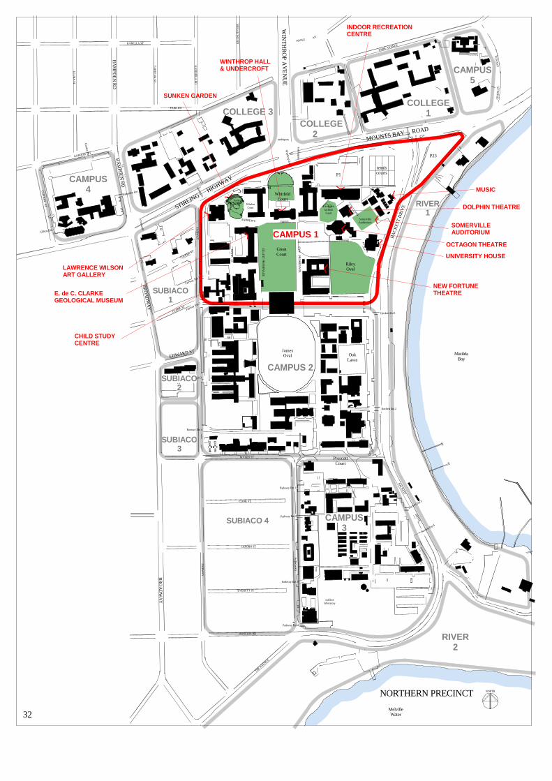
CHARACTERISTICS For the purposes of identifying the varying qualities and characteristics of the campus and its immediate extensions and neighbours, it can be divided into thirteen precincts, partly by land use and partly by physical constraints. CAMPUS 1 – NORTHERN PRECINCT INCLUDING CAR PARK 23 The location of the campus main entrance and the 1930 Hackett Memorial Buildings including Administration and also six major green spaces, five designated as Permanent Green Reserves: • Whitfeld Court, PGR • Great Court, PGR • Sunken Garden, PGR • Somerville Auditorium, PGR • Riley Oval, PGR • Lawrence Jackson Court The concentration of performing and visual arts facilities in the Northern Precinct causes major traffic and parking problems during public participation periods: • Winthrop Hall & Undercroft • Octagon, Dolphin and New FortuneTheatres • Somerville Auditorium • Sunken Garden • Lawrence Wilson Art Gallery • E.de C. Clarke Geological Museum
Because of the location of Car Park 1 and the Tennis Courts, appropriate expansion of both the Indoor Recreation Centre and School of Music is constrained. The relocation of the Indoor Recreation Centre to a site adjacent to Human Movement and Exercise Science in the southern precinct, with or without the Tennis Courts, would provide space for Music expansion, possibly with associated facilities. Alternatively, the relocation of Music, with associated facilities, to the south-east corner of the campus could establish a prominent presence in this area and act to reduce the impact of the concentration of performing arts facilities in the northern precinct. The existing University House – Staff Club is to be replaced by a new “Complex”, consisting of a University House, with high quality lecture and seminar facilities, at the southern end of Riley Oval. Car Park 23, included as part of the 999-year lease site, is separated from the main body of the campus by Hackett Drive but enjoys a River presence and could support some prestigious water front development on the boat shed site. The Child Study Centre / Media Services site has redevelopment potential and is an appropriate location for a second chilled water storage facility to help meet the increasing demands for air conditioning.
The Northern Precinct signals the ethos of the campus through the quality of its buildings and landscape, as well as its river presence.
The view of the Hackett Memorial Buildings from Stirling Highway and Mounts Bay Road and particularly from the Winthrop Avenue approach identifies the University to the community and should not be obstructed.

CAMPUS 2
CAMPUS4
COLLEGE 3 COLLEGE
2
CAMPUS5
SUBIACO1
SUBIACO3
SUBIACO 4
RIVER2
RIVER1
underpass
underpass
crosswalk
crosswalk
unde
rpas
s
MatildaBay
MelvilleWater
FAI R
WA
Y
BR
OA
DW
AY
CLARK ST
EDWARD ST
COOPER ST
F AIRW
AY
BR
OA
DW
AY
STIRLING HIGHWAY
CLIFTO
N ST
GORDON ST
KA
NIM
BLA
RD
KARELLA ST
TAR
EE
NA
ST
PARK RD
HA
MP D
EN
RD
LEU
RA
ST
HA
MPD
EN R
D
THE AVENUE
PRINCESS RD
EVERETT ST
CAPORN ST
COOK ST
MYERS ST
PARK
WA
Y
MOUNTS BAY ROAD
CRA
WLE
YA
VE
NU
E
DRIVEANDREW'S
SAW
PRO
ME N
AD
E
GILLETT PR
OM
ENA
DE
IRW
IN ST
HACK
ETT
DRIV
E
HA
CK
ETT
DR
IVE
PARK AVENUE
POOLEAV
WIN
TH
RO
P AV
EN
UE
MEG
ALO
NG
RD
outdoorlaboratory
PrescottCourt
P14
P13
tenniscourts
OakLawn
JamesOval
SunkenGdn Whelan
Court LawrenceJacksonCourt
SomervilleAuditorium
RileyOval
GreatCourt
WhitfeldCourt
Hampden Ent
Gordon Ent
Clifton Ent
Fairway Ent 2
Fairway Ent 1
Fairway Ent 3
Fairway Ent 4
Winthrop Ent
Hackett Ent 1
Hackett Ent 2
Hackett Ent 4
Hackett Ent 3
Parkway Ent 1
Parkway Ent 2
Parkway Ent 4
Parkway Ent 3
MIDDLE PRECINCTSOUTHERN PRECINCT
34
COLLEGE1
SUBIACO2
LAW SCHOOL
GUILD ADMINISTRATION& VILLAGE
SHENTON HOUSE
ANATOMY
BIOCHEMISTRY
INSTITUTE OFAGRICULTURE
CHEMISTRY
ENGINEERING
ELECTRICALENGINEERING
MATHEMATICS
PHYSICS
ELECTRONICENGINEERING
NORTH
CAMPUS 1
CAMPUS3

35
CAMPUS 2 – MIDDLE PRECINCT The location of the original Shenton farm and 1842 house, together with the second permanent building, constructed in 1927 for the University, and now converted for use as the Guild Tavern. Also the location of the Student Guild Administration and Village and two major green spaces, both designated as Permanent Green Reserves: • James Oval, PGR • Oak Lawn, PGR The Middle Precinct displays a variety of architectural styles, including the contextual group of buildings from Law to Anatomy, the 1960’s non-contextual group including Engineering, Chemistry, Biochemistry and Physics and, because of the domestic scale of the clay brick, the group including Mathematics, Electrical Engineering and Electronic Engineering. The Car Park 13, Car Park 14, Engineering and Chemistry sites have redevelopment potential. In terms of building and landscape quality, the west flank of this Precinct is not of the same standard as that of the east flank, nor of the Northern Precinct. CAMPUS 3 – SOUTHERN PRECINCT The location of the 1938 Institute of Agriculture building and of two major green spaces, one designated as a Permanent Green Reserve: • Prescott Court, PGR • Human Movement Outdoor Laboratory The logical extension of the planning structure of the Northern and Middle Precincts into the Southern Precinct was not possible because of the constriction at Myers Street. Appropriate development on the west flank of the Precinct is constrained by a narrow strip of site between Parkway and a major north-south service corridor. The disparity between the building and landscape qualities of the Southern and Northern Precincts can be partially remedied by sensitive handling of development on the eastern and, particularly, the southern flank which has the potential for development of a large prominent group of buildings achieving the status of the Hackett Memorial Buildings.

CAMPUS 4 PRECINCTNEDLANDS SITE
EXISTING
POSSIBLE
36
NORTH
GORDON STREET
STIRLING HIGHWAY
HA
MP
DE
N R
OA
D
CLI
FTO
N S
TRE
ET
BR
OA
DW
AY
PEDESTRIANTUNNEL
GREATCOURT
HOCKEYFIELD
GORDON STREET
STIRLING HIGHWAY
HA
MP
DE
N R
OA
D
CLI
FTO
N S
TRE
ET
SLIPROAD
BRIDGELINKS
TWO LEVELCAR PARK
BR
OA
DW
AY
LEGEND
GREEN SPACE
PATHS
PROPOSED BUILDINGS
CARPARKS
EXISTING BUILDINGS
37
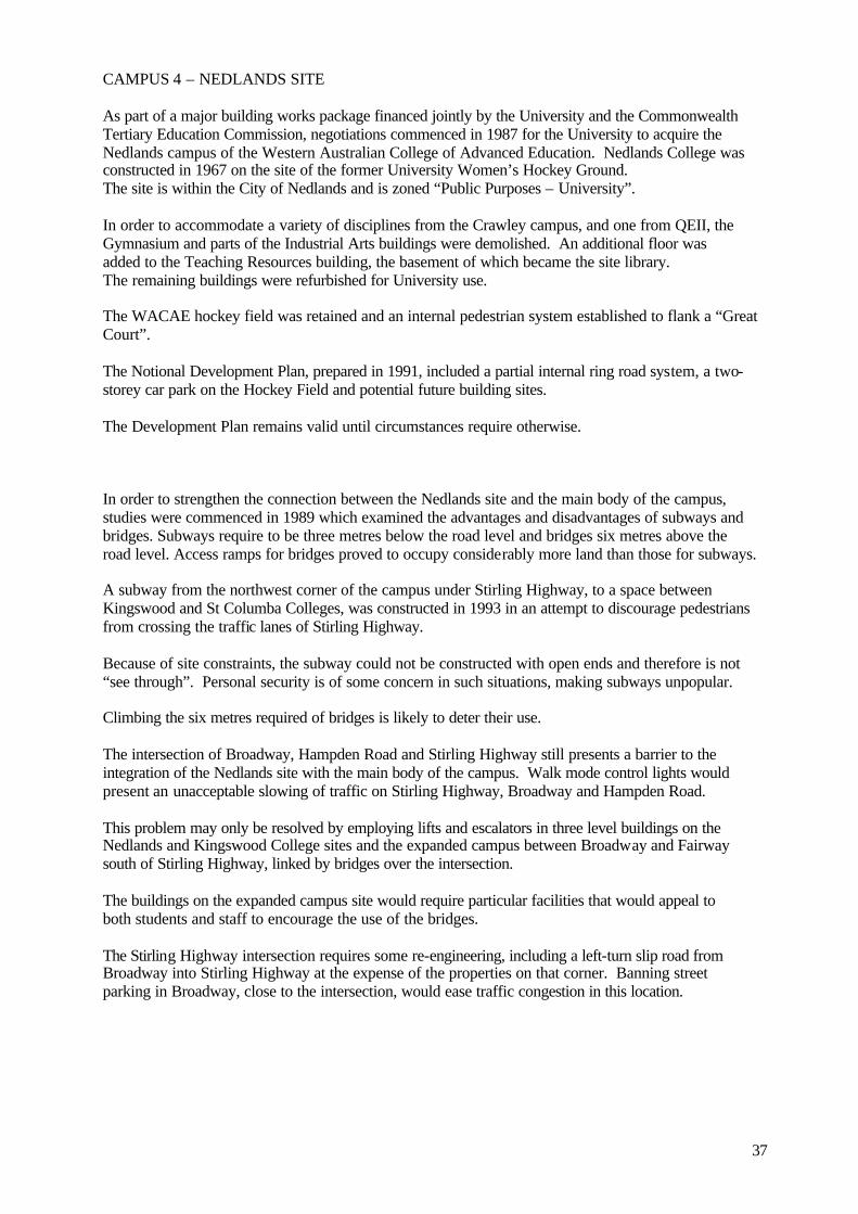
CAMPUS 4 – NEDLANDS SITE As part of a major building works package financed jointly by the University and the Commonwealth Tertiary Education Commission, negotiations commenced in 1987 for the University to acquire the Nedlands campus of the Western Australian College of Advanced Education. Nedlands College was constructed in 1967 on the site of the former University Women’s Hockey Ground. The site is within the City of Nedlands and is zoned “Public Purposes – University”. In order to accommodate a variety of disciplines from the Crawley campus, and one from QEII, the Gymnasium and parts of the Industrial Arts buildings were demolished. An additional floor was added to the Teaching Resources building, the basement of which became the site library. The remaining buildings were refurbished for University use. The WACAE hockey field was retained and an internal pedestrian system established to flank a “Great Court”. The Notional Development Plan, prepared in 1991, included a partial internal ring road system, a two-storey car park on the Hockey Field and potential future building sites. The Development Plan remains valid until circumstances require otherwise. In order to strengthen the connection between the Nedlands site and the main body of the campus, studies were commenced in 1989 which examined the advantages and disadvantages of subways and bridges. Subways require to be three metres below the road level and bridges six metres above the road level. Access ramps for bridges proved to occupy considerably more land than those for subways. A subway from the northwest corner of the campus under Stirling Highway, to a space between Kingswood and St Columba Colleges, was constructed in 1993 in an attempt to discourage pedestrians from crossing the traffic lanes of Stirling Highway. Because of site constraints, the subway could not be constructed with open ends and therefore is not “see through”. Personal security is of some concern in such situations, making subways unpopular. Climbing the six metres required of bridges is likely to deter their use. The intersection of Broadway, Hampden Road and Stirling Highway still presents a barrier to the integration of the Nedlands site with the main body of the campus. Walk mode control lights would present an unacceptable slowing of traffic on Stirling Highway, Broadway and Hampden Road. This problem may only be resolved by employing lifts and escalators in three level buildings on the Nedlands and Kingswood College sites and the expanded campus between Broadway and Fairway south of Stirling Highway, linked by bridges over the intersection. The buildings on the expanded campus site would require particular facilities that would appeal to both students and staff to encourage the use of the bridges. The Stirling Highway intersection requires some re-engineering, including a left-turn slip road from Broadway into Stirling Highway at the expense of the properties on that corner. Banning street parking in Broadway, close to the intersection, would ease traffic congestion in this location.

CAMPUS 5 PRECINCTPARK AVENUE SITE
38
NORTH
POSSIBLE
EXISTING
PARK AVENUE
MOUNTS BAY ROAD
PARK AVENUEBUILDING
TUART HOUSE
CR
AW
LEY
AV
EN
UE
ST GEORGE'SCOLLEGE
PARK AVENUE
MOUNTS BAY ROAD
PARK AVENUEBUILDING
CR
AW
LEY
AV
EN
UE
ST GEORGE'SCOLLEGE
POSSIBLE UNDERCROFTCAR PARKING
HA
CK
ET
T D
RIV
EH
AC
KE
TT D
RIV
E
GREEN SPACE
PATHS
PROPOSED BUILDINGS
CARPARKS
LEGEND
EXISTING BUILDINGS

39
CAMPUS 5 – PARK AVENUE SITE The first permanent building constructed for the University opened in 1925 at the northern end of the Park Avenue site and was designed by the Public Works Department to accommodate facilities for Biology and Geology. A part single, part two-storey extension was completed in 1945 by the Public Works Department. In 1947 the Chair of Biology changed its title to ‘Zoology’. Geology remained on the site until 1962, when the Department moved to the building on the main body of the campus constructed for Physics and Chemistry in 1935 and which is now known as the Geology and Geography building. Zoology occupied the whole building on the Park Avenue site, as well as additional structures and animal yards, until it moved to new premises in the southern campus in 1993. Tuart House, the first official residence for the University’s Vice-Chancellor, was constructed on the southern section of the site in 1934. In 1960 the building was vacated by the Vice-Chancellor of the time and the building was converted for use by the Department of Music, until that Department moved into new premises adjacent to Somerville Auditorium in 1976. Currently Tuart House provides accommodation for the Perth International Arts Festival and University of Western Australia Press. The site, within the Crawley Precinct of the City of Perth, falls steeply down to Mounts Bay Road and enjoys sweeping views of the Swan River to the south. The site is zoned “Public Purposes – University”. Traffic movement on Mounts Bay Road presents a barrier to the integration of the Park Avenue site with the main body of the campus. Walk mode control lights would present an unacceptable slowing of traffic on Mounts Bay Road and Hackett Drive. Without appropriate pedestrian tunnels or bridge links, the site is not well suited to undergraduate teaching. The location and prominence of the site would suit research, residential, conference centre or other “public interface” facilities which did not require constant or intimate connection to the main body of the campus. The natural levels of the site would accommodate undercroft car parking and an internal landscaped court could be created south of the original Biology, Geology building. The Biology, Geology building (now known as the Park Avenue building) is entered in the Register of Heritage Places. The site requires development compatible with the residential use of St George’s College and adjacent City of Perth apartments and which does not turn its back on the magnificent river views to the south.

CAMPUS 2
CAMPUS4
COLLEGE 3 COLLEGE
2
CAMPUS5
SUBIACO1
SUBIACO3
SUBIACO 4
RIVER2
RIVER1
underpass
underpass
crosswalk
crosswalk
unde
rpas
s
MatildaBay
MelvilleWater
ST GEORGE'SCOLLEGEST THOMAS
MORE COLLEGECURRIE
HALL
ST CATHERINE'SCOLLEGE
KINGSWOODCOLLEGE
ST COLUMBACOLLEGE
FAI R
WA
Y
BR
OA
DW
AY
CLARK ST
EDWARD ST
COOPER ST
F AIRW
AY
BR
OA
DW
AY
STIRLING HIGHWAY
CLIFTO
N ST
GORDON ST
KA
NIM
BLA
RD
KARELLA ST
TAR
EE
NA
ST
PARK RD
HA
MP D
EN
RD
LEU
RA
ST
HA
MPD
EN R
D
THE AVENUE
PRINCESS RD
EVERETT ST
CAPORN ST
COOK ST
MYERS ST
PARK
WA
Y
MOUNTS BAY ROAD
CRA
WLE
YA
VE
NU
E
DRIVEANDREW'S
SAW
PRO
ME N
AD
E
GILLETT PR
OM
ENA
DE
IRW
IN ST
HACK
ETT
DRIV
E
HA
CK
ETT
DR
IVE
PARK AVENUE
POOLEAV
WIN
TH
RO
P AV
EN
UE
MEG
ALO
NG
RD
outdoorlaboratory
PrescottCourt
tenniscourts
P23
P9
OakLawn
JamesOval
SunkenGdn Whelan
Court LawrenceJacksonCourt
SomervilleAuditorium
RileyOval
GreatCourt
WhitfeldCourt
Hampden Ent
Gordon Ent
Clifton Ent
Fairway Ent 2
Fairway Ent 1
Fairway Ent 3
Fairway Ent 4
Winthrop Ent
Hackett Ent 1
Hackett Ent 2
Hackett Ent 4
Hackett Ent 3
Parkway Ent 1
Parkway Ent 2
Parkway Ent 4
Parkway Ent 3
COLLEGE PRECINCTS
40
COLLEGE1
SUBIACO2
NORTH
CAMPUS 1
CAMPUS3

41
RESIDENTIAL COLLEGE PRECINCTS The red brick Tudor styled buildings of St George’s College followed the traditional styling of Oxford and Cambridge in direct contrast to the “Mediterranean” styling of the Hackett Memorial Buildings constructed at the same time. The other six colleges constructed much later, at various times, generally observe their contextual responsibilities to the buildings of the main campus. The landscape qualities of all colleges complement those of the main campus Northern Precinct. This review does not include any planning proposals for the College precincts. However, as these areas continue to be developed, it would be appropriate for an overall planning strategy for these areas to be put in place. PRECINCT 1. Sites owned by the Churches. The location of St. George’s College constructed in 1930 with funds from the Hackett bequest. Also of St. Thomas More College opened in 1955.
PRECINCT 2. Site owned by the University Originally the location of the Second World War United States Bachelor Officer Quarters converted to a residential hostel for male and female students in 1946 and progressively demolished to make way for the construction of Currie Hall in 1965.
PRECINCT 3. Sites owned by the Churches. The location of St. Catherine’s College opened in 1960. Also Kingswood College opened in 1962 and St. Columba College opened in 1971. The pedestrian underpass at the intersection of Winthrop Avenue, Stirling Highway and Mounts Bay Road adequately links Currie Hall and St Catherine’s College to the campus, but it is not close enough to St. Thomas More and St. George’s Colleges to encourage its use by these Colleges. Safe pedestrian passage across Mounts Bay Road could be improved by an underpass or bridge link to the campus immediately west of the intersection of Hackett Drive and Mounts Bay Road. The pedestrian underpass at the intersection of Fairway and Stirling Highway adequately links Kingswood and St. Columba Colleges with the campus, but safety could be improved with better vision at the College end of the underpass.

CAMPUS 2
CAMPUS4
COLLEGE 3 COLLEGE
2
CAMPUS5
SUBIACO1
SUBIACO3
SUBIACO 4
RIVER2
RIVER1
underpass
underpass
crosswalk
crosswalk
unde
rpas
s
MatildaBay
MelvilleWater
ABRAHAMSRESERVE
ABRAHAMSRESERVE
PELICANPOINT
P23
FAIR W
AY
BR
OA
DW
AY
CLARK ST
EDWARD ST
COOPER ST
FAIR
WA
Y
BR
OA
DW
AY
STIRLING HIGHWAY
CLIFTO
N ST
GORDON ST
KA
NIM
BLA
RD
KARELLA ST
TA
REE
NA
ST
PARK RD
HA
MPD
EN
RD
LEU
RA
ST
HA
MPD
EN
RD
THE AVENUE
PRINCESS RD
EVERETT ST
CAPORN ST
COOK ST
MYERS ST
PAR
KW
AY
MOUNTS BAY ROAD
CRA
WLE
YA
VEN
UE
DRIVEANDREW'S
SAW
P RO
MEN
AD
E
GILLETT PRO
MEN
AD
E
IRW
IN S T
HA
CKETT
DRIVE
HA
CK
ETT
DR
IVE
PARK AVENUE
POOLEAV
WI N
TH
RO
P AV
EN
UE
MEG
ALO
NG
RD
outdoorlaboratory
PrescottCourt
tenniscourts
OakLawn
JamesOval
SunkenGdn Whelan
Court LawrenceJacksonCourt
SomervilleAuditorium
RileyOval
Cygnet Hall
Ramp
GreatCourt
WhitfeldCourt
Hampden Ent
Gordon Ent
Clifton Ent
Fairway Ent 2
Fairway Ent 1
Fairway Ent 3
Fairway Ent 4
Winthrop Ent
Hackett Ent 1
Hackett Ent 2
Hackett Ent 4
Hackett Ent 3
Parkway Ent 1
Parkway Ent 2
Parkway Ent 4
Parkway Ent 3
RIVER PRECINCTS
42
COLLEGE1
SUBIACO2
NORTH
CAMPUS 1
CAMPUS3

43
RIVER PRECINCTS 1 AND 2 These precincts include: • Matilda Bay Reserve – an A-class reserve which covers 20.6 ha extending from north of Cygnet
Hall to south of the ramp south of Pelican Point. The Reserve is Gazetted for Recreation and is managed by the Department of Conservation and Land Management.
• Pelican Point Nature Reserve, which is part of the Swan Estuary Marine Park managed by CALM. • Abrahams Park – a park maintained for open public use and managed by the City of Subiaco. • Nedlands Foreshore Reserve – south of Abrahams Reserve and incorporates the Nedlands Yacht
Club and the Perth Flying Squadron Yacht Club. The Swan River Trust is responsible for the planning, management and protection of the Swan River Trust Management Area, which includes the waters of the Swan-Canning River system and adjoining Metropolitan Region Scheme Parks and Recreation Reserves. The Matilda Bay Reserve and Pelican Point Nature Reserve fall within the Swan River Trust Management Area. A number of leases occur on the Matilda Bay Reserve, including sailing clubs, rowing clubs, sea scouts, a kiosk and restaurant. CALM also maintains offices in this area. University students have increasingly made use of the Reserve parking and other facilities. A specific characteristic of the Reserve is that it is a natural extension of the campus landscape and river. Although not controlled by the University, it is critical to the environmental qualities of the campus for the University to influence the maintenance and appropriate development of the Reserve. This is being achieved by means of cooperative meetings between CALM and the University. Both precincts are used extensively by the general community for passive recreation and, because the University has an “open” campus, the community enjoys direct access to campus facilities. The precincts afford the opportunities for appropriate University/community interface and riverside development in selected areas. Hackett Drive is a popular scenic drive especially for residents of the southern suburbs of Nedlands and Dalkeith accessing the City of Perth. Hackett Drive also serves to relieve traffic congestion on Broadway and Fairway for those accessing the campus, but it does disrupt the visual continuity and pedestrian access between the University and the Reserve. In order to reduce this disruption and the impact of traffic movement on the many users of the Reserve, CALM has explored options such as the closure of Hackett Drive and also several “slowing devices” for the length of the Drive.
Unless there is a significant down-turn in the use of motor vehicles or until adequate alternative traffic routes are established, it should be assumed that traffic movement pressures on Hackett Drive will increase.

CAMPUS 2
CAMPUS4
COLLEGE 3 COLLEGE
2
CAMPUS5
SUBIACO1
SUBIACO3
SUBIACO 4
RIVER2
RIVER1
underpass
underpass
crosswalk
crosswalk
unde
rpas
s
MatildaBay
MelvilleWater
FAIR W
AY
BR
OA
DW
AY
CLARK ST
EDWARD ST
COOPER ST
FAIR
WA
Y
BR
OA
DW
AY
STIRLING HIGHWAY
CLIFTO
N ST
GORDON ST
KA
NIM
BLA
RD
KARELLA ST
TA
REE
NA
ST
PARK RD
HA
MPD
EN
RD
LEU
RA
ST
HA
MPD
EN
RD
THE AVENUE
PRINCESS RD
EVERETT ST
CAPORN ST
COOK ST
MYERS ST
PAR
KW
AY
MOUNTS BAY ROAD
CRA
WLE
YA
VEN
UE
DRIVEANDREW'S
SAW
P RO
MEN
AD
E
GILLETT PRO
MEN
AD
E
IRW
IN S T
HA
CKETT
DRIVE
HA
CK
ETT
DR
IVE
PARK AVENUE
POOLEAV
WI N
TH
RO
P AV
EN
UE
MEG
ALO
NG
RD
outdoorlaboratory
PrescottCourt
tenniscourts
OakLawn
JamesOval
P21
SunkenGdn Whelan
Court LawrenceJacksonCourt
SomervilleAuditorium
RileyOval
GreatCourt
WhitfeldCourt
Hampden Ent
Gordon Ent
Clifton Ent
Fairway Ent 2
Fairway Ent 1
Fairway Ent 3
Fairway Ent 4
Winthrop Ent
Hackett Ent 1
Hackett Ent 2
Hackett Ent 4
Hackett Ent 3
Parkway Ent 1
Parkway Ent 2
Parkway Ent 4
Parkway Ent 3
SUBIACO PRECINCTS
44
COLLEGE1
SUBIACO2
NORTH
CAMPUS 1
CAMPUS3

45
SUBIACO PRECINCTS Some, if not all, of the properties in the Subiaco Precincts will be required for the long-term expansion of the campus, not necessarily for undergraduate teaching but for University/public interface development, such as exists between Broadway and Fairway south of Edward Street. Appropriate zoning and controls are required to facilitate this development and to enable the preparation of a structure plan to encourage the extension of the campus green spaces at least to Broadway. PRECINCT 1 Bounded by Stirling Highway, Fairway, Edward Street and Broadway. Approximately 75% of the lots in this Precinct are owned by the University. Is an important area for University expansion and resolution of the tenuous connection between the Nedlands and Crawley sites. Because of the natural ground levels, there is potential for parking facilities under buildings at the southern end of the Precinct.
PRECINCT 2 Bounded by Edward Street, Fairway and Broadway and Car Park 21. The location of accommodation for CSIRO and TISC and also Car Park 21 which was designed for expansion. The site is owned by the University and zoned “Public Purposes – University” in the City of Subiaco Draft Planning Scheme No. 4.
PRECINCT 3 Bounded by Car Park 21, Fairway, Myers Street and Broadway. Approximately 25% of the lots in this Precinct are owned by the University. The extreme level difference between Broadway down to Fairway makes the site eminently suitable for multi-level car parking facilities below the level of Broadway.
PRECINCT 4 Bounded by Myers Street, Parkway, Princess Road and Fairway. Approximately 45% of the lots in this Precinct are owned by the University. This Precinct presents the opportunity to extend the campus structure of the Northern and Middle Campus Precincts into the Southern Campus Precinct and has great potential for integrated University and private development. Precincts 1, 2 and 3 could support intensive commercial development, urban in scale and character, on the Stirling Highway and Broadway frontages which would be compatible with the spirit of the City of Subiaco Draft Town Planning Scheme No. 4. Alternative student/staff housing types – other than halls of residence – could be accommodated in Precinct 4 and not necessarily initiated by the University. The acquisition of properties in these Precincts by the University will depend on the availability of the properties. It must be assumed that University development in the Precincts will be a long-term venture.
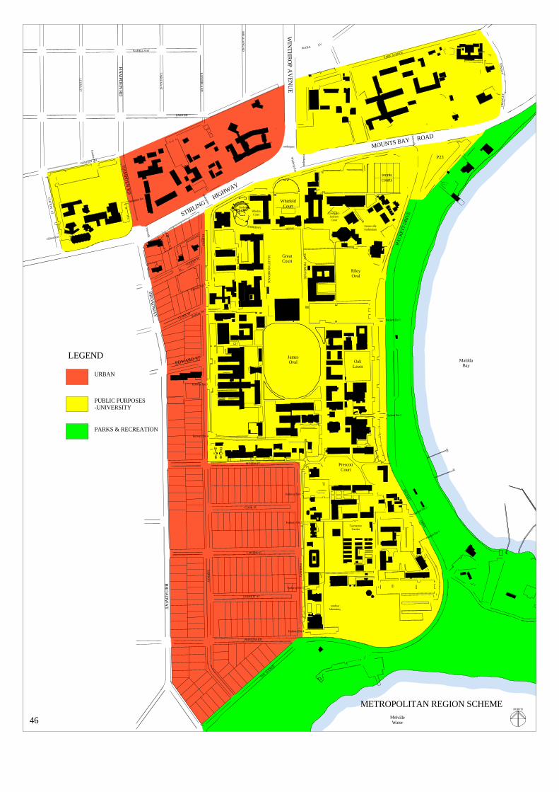
underpass
underpass
crosswalk
crosswalk
unde
rpas
s
MatildaBay
MelvilleWater
FAI R
WA
Y
BR
OA
DW
AY
CLARK ST
EDWARD ST
COOPER ST
F AIRW
AY
BR
OA
DW
AY
STIRLING HIGHWAY
CLIFTO
N ST
GORDON ST
KA
NIM
BLA
RD
KARELLA ST
TAR
EE
NA
ST
PARK RD
HA
MP D
EN
RD
LEU
RA
ST
HA
MPD
EN R
D
THE AVENUE
PRINCESS RD
EVERETT ST
CAPORN ST
COOK ST
MYERS ST
PARK
WA
Y
MOUNTS BAY ROAD
CRA
WLE
YA
VE
NU
E
DRIVEANDREW'S
SAW
PRO
ME N
AD
E
GILLETT PR
OM
ENA
DE
IRW
IN ST
HACK
ETT
DRIV
E
HA
CK
ETT
DR
IVE
PARK AVENUE
POOLEAV
WIN
TH
RO
P AV
EN
UE
MEG
ALO
NG
RD
outdoorlaboratory
TaxonomicGarden
PrescottCourt
tenniscourts
P23
OakLawn
JamesOval
SunkenGdn Whelan
Court LawrenceJacksonCourt
SomervilleAuditorium
RileyOval
GreatCourt
WhitfeldCourt
Hampden Ent
Gordon Ent
Clifton Ent
Fairway Ent 2
Fairway Ent 1
Fairway Ent 3
Fairway Ent 4
Winthrop Ent
Hackett Ent 1
Hackett Ent 2
Hackett Ent 4
Hackett Ent 3
Parkway Ent 1
Parkway Ent 2
Parkway Ent 4
Parkway Ent 3
METROPOLITAN REGION SCHEME
46
NORTH
URBAN
PUBLIC PURPOSES-UNIVERSITY
PARKS & RECREATION
LEGEND

47
AUTHORITIES METROPOLITAN REGION SCHEME The Metropolitan Region Scheme shows the main campus, including Car Park 23, the Park Avenue and Nedlands sites, zoned “Public Purposes – University”. The sites of Currie Hall, St. Thomas More and St. George’s Colleges are also zoned “Public Purposes – University”. The sites of Kingswood, St. Columba and St. Catherine’s Colleges are zoned “Urban” apparently because no college development had commenced at the time of preparing the Metropolitan Region Scheme. The sites between Stirling Highway and Princess Road contained by Broadway and Fairway and Parkway, are currently zoned “Urban”. Some other zoning, more appropriate for the University’s expansion aims, may be required if suitable amendments to the City of Subiaco Planning Scheme No. 4 can be achieved. The two river foreshore precincts are zoned “Parks and Recreation” and are controlled by CALM and Swan River Trust. In order to obtain Development Approval for building projects on the main campus, the University is required to submit proposals to the State Planning Commission via the relevant Local Authority which can make observations on the particular proposals and recommendations to the Commission. Development on the Park Avenue site requires a building licence from the Perth City Council. The Colleges in the “Public Purposes –University” zone make direct application to the Local Authority for a Building Licence – in this instance, the Perth City Council. The Colleges in the “Urban” zone make direct application to the Local Authority for a Building Licence – in this instance the Subiaco City Council.

underpass
underpass
crosswalk
crosswalk
unde
rpas
s
MatildaBay
MelvilleWater
FAI R
WA
Y
BR
OA
DW
AY
CLARK ST
EDWARD ST
COOPER ST
F AIRW
AY
BR
OA
DW
AY
STIRLING HIGHWAY
CLIFTO
N ST
GORDON ST
KA
NIM
BLA
RD
KARELLA ST
TAR
EE
NA
ST
PARK RD
HA
MP D
EN
RD
LEU
RA
ST
HA
MPD
EN R
D
THE AVENUE
PRINCESS RD
EVERETT ST
CAPORN ST
COOK ST
MYERS ST
PARK
WA
Y
MOUNTS BAY ROAD
CRA
WLE
YA
VE
NU
E
DRIVEANDREW'S
SAW
PRO
ME N
AD
E
GILLETT PR
OM
ENA
DE
IRW
IN ST
HACK
ETT
DRIV
E
HA
CK
ETT
DR
IVE
PARK AVENUE
POOLEAV
WIN
TH
RO
P AV
EN
UE
MEG
ALO
NG
RD
outdoorlaboratory
TaxonomicGarden
PrescottCourt
tenniscourts
OakLawn
JamesOval
P21
SunkenGdn Whelan
Court LawrenceJacksonCourt
SomervilleAuditorium
RileyOval
GreatCourt
WhitfeldCourt
Hampden Ent
Gordon Ent
Clifton Ent
Fairway Ent 2
Fairway Ent 1
Fairway Ent 3
Fairway Ent 4
Winthrop Ent
Hackett Ent 1
Hackett Ent 2
Hackett Ent 4
Hackett Ent 3
Parkway Ent 1
Parkway Ent 2
Parkway Ent 4
Parkway Ent 3
CITY OF PERTH
CITY OF SUBIACO
CITY OFNEDLANDS
LOCAL AUTHORITIESBOUNDARIES & ZONING
48
NORTH
U
U
R50
R50
R50
R50
R50R20/R50
R20/R50
R20/R50
R20/R50
R50
R50
R80
NM
NM
NM
NM
NM
NM
CITY OF SUBIACODRAFT PLANNING SCHEME NO 4
PUBLIC PURPOSES - UNIVERSITY
NEIGHBOURHOODMIXED USE
U
NM
RESIDENTIAL
LEGEND
CITY OF PERTHCITY PLANNING SCHEME 1985
PUBLIC PURPOSES - UNIVERSITY
CITY OF NEDLANDSTOWN PLANNING SCHEME NO. 2
PUBLIC PURPOSES - UNIVERSITY
U

49
LOCAL AUTHORITIES Nedlands City Council The Nedlands site is within the City of Nedlands and zoned “Public Purposes – University” in its Town Planning Scheme No. 2. Perth City Council The extreme north-east corner of the campus including Car Park 23 and the Park Avenue site, with the Currie Hall, St. Thomas More and St. George’s Colleges sites, are within the City of Perth and are zoned “Public Purposes – University” in its Planning Scheme 1985. Subiaco City Council The City of Subiaco Draft Town Planning Scheme 1998 (No. 4), at the time of this Review, is being processed by the Western Australian Planning Commission before presentation to the Minister for Planning for approval or otherwise. The Draft Scheme shows the section of campus within the City as zoned “University”. The Kingswood, St. Columba and St. Catherine’s Colleges and Car Park 21 sites are zoned “Public Purposes – University”. In the strip between Stirling Highway and Princess Road, properties fronting Broadway are zoned “Neighbourhood Mixed Use”. Other properties between Broadway and Fairway are zoned “Residential R50”. Properties between Myers Street, Parkway, Princess Road and Fairway are zoned “Residential R20/50”. Residential R20 codes are based on 20 housing units per hectare and R50 are based on 50 housing units per hectare.
A single-storey height limit is proposed for the areas zoned “Neighbourhood Mixed Use” and “Residential R50 and R20/R50”. The single-storey height limit may be elevated to two-storeys at Council’s discretion. The Residential R20/50 zone is actually R20, but can be elevated to R50, at Council’s discretion, if certain conditions are met. The area bounded by Stirling Highway, Fairway, Myers Street and Broadway and the area bounded by Myers Street, Parkway, Princess Road and Fairway, are critical to the expansion needs of the University. Expansion sought by the University is required to protect the established qualities of the campus and to accommodate development which would service the University and the wider community – including facilities for collaborative ventures with Government, industry and other tertiary institutions. An example of such a facility already exists in the form of a building for CSIRO and TISC, both with University connections and public interface, on a site bounded by Broadway and Fairway south of Edward Street. To help meet some of its particular expansion needs, the University has acquired the Nedlands campus of the Western Australian College of Advanced Education; and approximately half the properties in the area between Stirling Highway, Fairway, Myers Street and Broadway and the area between Myers Street, Parkway, Princess Road and Fairway. The University may never own all the properties in those areas and may not need to do so in order to achieve its expansion needs.


51
HERITAGE AND CONSERVATION The nation has inherited the considerable qualities of the architecture, landscape and community service sponsored by The University of Western Australia since its foundation in 1912 and the first physical development of the Crawley campus in 1914. Few institutions can equal the success of the University in its site selection, structure planning, development of the built form and landscaped spaces and the identification, conservation and management of these assets consistently over an 86 year period. The University is constantly evolving and has never deviated from its search for and delivery of knowledge. Its facilities – spaces, structures, equipment and services must grow and change to provide appropriate support for its diverse functions. Few, if any, of these facilities can be frozen in time. In its evolution, the University has progressively constructed, demolished and altered its building stock. It has consistently developed and redeveloped its grounds and has initiated new and upgraded established equipment and services. All has been done with dedication and in a manner which has achieved a campus of national importance in terms of its cultural heritage significance and which is of maximum benefit to the University itself. The “Gardens” and several buildings of the Crawley campus and of St. George’s College have been recognised by the Australian Heritage Commission, the Heritage Council of Western Australia, the National Trust and the Local Authorities in their respective registers and inventories. The formalisation of this recognition, by listing in these Registers and inventories, could impose controls which may not be in the best long-term interests of the University or College and therefore the nation. The ad hoc listing of places of merit and the subsequent restrictions on their redevelopment does not encourage the creation of such places. CONSERVATION PLAN The Crawley campus of The University of Western Australia is of cultural heritage significance, not because of one, or even several, prominent elements but because of the integrity and totality of the physical qualities of the whole campus and the educational and cultural achievements of the University itself. To protect the campus from ad hoc listing of elements in the various registers and, particularly, their controls which may inhibit the appropriate development of the campus, a “conservation plan” should be prepared. Not necessarily a conservation plan as defined by, nor for the purposes of, the Heritage Council, but a plan which would establish what is significant about the campus and what policies or guidelines are required to protect and enhance that significance in the evolving use, development and redevelopment of the campus. The indigenous heritage of the campus site should be acknowledged. The conservation plan should not be a rigid set of rules but should present guidelines for development and redevelopment and would be under frequent revision as the campus is subjected to unpredictable pressures and requirements for change. The conservation plan should not freeze elements in time but should encourage the constant improvement of all the existing campus assets and the pursuit of contextual excellence in any new development.

52
HERITAGE COUNCIL OF WESTERN AUSTRALIA The Heritage Council was set up under the Heritage of Western Australia Act 1990 as the State’s advisory body on heritage matters. Its mission is to provide for and encourage the conservation of places which have significance to the cultural heritage of the State. Apparently the Heritage Council understands that The University of Western Australia fulfils the definition of a “public authority” within the Act: The consequence of which is: “A decision-making authority shall not take any action that might (whether or not adversely) affect to a significant extent a registered place or a place which is the subject of a Heritage Agreement (even though that action is not directly related to the place) unless: the authority has informed the Council of the proposed action and given the Council a reasonable
opportunity to consider it and to advise both the Minister and that authority; that action is consistent with advice received from the Council, or there is no feasible and prudent
alternative to the taking of that action; and According to the Heritage Council the Heritage Act defines: • development as including any work to a building, structure or part of a building or structure that
involves: demolition; erection, construction or relocation; renovation, addition and alteration including internal work.
• development also includes proposals affecting the registered land;
subdivision; change of use; excavation, disturbance or change to landscape or natural features of land that substantially alters the appearance of the place (including any works affecting significant plantings); other works.
The Act does not define preservation. The Australian ICOMOS Charter for the conservation of places of cultural significance (Burra Charter) does: • preservation means maintaining the fabric of a place in its existing state and retarding
deterioration. • maintenance means the continuous protective care of the fabric , contents and setting of a place. The aim of The Heritage Council (in requiring that development of a place entered in the Register not proceed without the “advice” of the Council) is to ensure that the cultural heritage significance of the place is conserved by appropriate means. Seeking, agreeing and complying with that “advice” could be time consuming, costly and constrain the appropriate use, reconstruction or adaptation of those places for University purposes.

53
Register Of Heritage Places Places entered in the Register on the advice of the Heritage Council or at the direction of the Minister for Heritage are given legal protection under the Heritage of Western Australia Act 1990. The Act was established to provide for and to encourage the conservation of places, which have significance to the cultural heritage in the State, to establish the Heritage Council of Western Australia and for related purposes. The Act requires that any development of these places conforms to the “advice” of the Heritage Council, which must be sought prior to development proceeding. The Act definitions: Conservation means, in relation to any place, the management of that place in a manner that will: (a) enable the cultural heritage significance of that place to be retained; and (b) yield the greatest sustainable benefit for the present community without diminishing the cultural
heritage significance of that place, and may include the preservation, stabilization, protection, restoration, reconstruction, adaptation and maintenance of that place in accordance with relevant professional standards and the provision of an appropriate visual setting. Cultural heritage significance means, in relation to a place, the relative value which that place has in terms of its aesthetic, historic, scientific, or social significance, for the present community and future generations. National Trust Of Australia (WA) The Trust identifies and maintains a list of properties of heritage significance to the State and is custodian of heritage assets vested in it. The Trust does not have any legal powers to enforce, but does encourage the conservation of heritage places. Register Of The National Estate The Register of natural, Aboriginal and European heritage items of significance to the Nation is compiled and maintained by the Australian Heritage Commission and includes both interim and permanent listings. Those items or places on the Register are only afforded legal protection if owned by the Commonwealth. Local Authority Municipal Inventories Local councils are required by the Heritage of Western Australia Act 1990 to compile a Municipal Inventory of items which, in the opinion of the local council, are, or may become, of cultural heritage significance. Such items or places listed on the Inventories are not afforded legal protection unless by inclusion in the Authority’s Town Planning Scheme. At the time of this Review, the City of Perth was updating its Municipal Inventory.

underpass
underpass
crosswalk
crosswalk
unde
rpas
s
MatildaBay
MelvilleWater
FAI R
WA
Y
BR
OA
DW
AY
CLARK ST
EDWARD ST
COOPER ST
F AIRW
AY
BR
OA
DW
AY
STIRLING HIGHWAY
CLIFTO
N ST
GORDON ST
KA
NIM
BLA
RD
KARELLA ST
TAR
EE
NA
ST
PARK RD
HA
MP D
EN
RD
LEU
RA
ST
HA
MPD
EN R
D
THE AVENUE
PRINCESS RD
EVERETT ST
CAPORN ST
COOK ST
MYERS ST
PARK
WA
Y
MOUNTS BAY ROAD
CRA
WLE
YA
VE
NU
E
DRIVEANDREW'S
SAW
PRO
ME N
AD
E
GILLETT PR
OM
ENA
DE
IRW
IN ST
HACK
ETT
DRIV
E
HA
CK
ETT
DR
IVE
PARK AVENUE
POOLEAV
WIN
TH
RO
P AV
EN
UE
MEG
ALO
NG
RD
outdoorlaboratory
TaxonomicGarden
PrescottCourt
tenniscourts
OakLawn
JamesOval
SunkenGdn Whelan
Court LawrenceJacksonCourt
SomervilleAuditorium
RileyOval
GreatCourt
WhitfeldCourt
Hampden Ent
Gordon Ent
Clifton Ent
Fairway Ent 2
Fairway Ent 1
Fairway Ent 3
Fairway Ent 4
Winthrop Ent
Hackett Ent 1
Hackett Ent 2
Hackett Ent 4
Hackett Ent 3
Parkway Ent 1
Parkway Ent 2
Parkway Ent 4
Parkway Ent 3
LISTED PLACES
54
NORTH
ST GEORGE'SCOLLEGE
PARK AVENUEBUILDING
(OLD ZOOLOGY)
TUARTHOUSE
MUSIC BUILDINGS
OCTAGON THEATRE
REID LIBRARY
LAW SCHOOL
IRWIN STREET BUILDING(ORIGINAL UNIVERSITYBUILDING)
SHENTON HOUSE(CRAWLEY HOUSE)
INSTITUTE OFAGRICULTURE
NEDLANDS PARKMASONIC HALL
HACKETT MEMORIALBUILDINGS

55
LISTED PLACES Shenton House (1846) Entered in the Register of Heritage Places. Classified by the National Trust. Entered in the Register of the National Estate. Listed on the City of Subiaco Municipal Inventory. Irwin Street Building (Moved to Crawley Campus 1932. Rebuilt on James Oval 1986) Classified by the National Trust. Entered in the Register of the National Estate.
Park Avenue Building (1925) (Originally Biology and Geology then Zoology.) Entered in the Register of Heritage Places. Classified by the National Trust. Entered in the Register of the National Estate. Listed on the City of Perth Municipal Inventory. Hackett Memorial Buildings (1930-1932. Hackett Hall extended 1961. Bookshop 1962.) Entered in the Register of Heritage Places. Classified by the National Trust. Entered in the Register of the National Estate. Listed on the City of Subiaco Municipal Inventory. Hackett Hall listed on the City of Perth Municipal Inventory.
Tuart House (1934) Being considered for entry in the Register of Heritage Places. Listed on the City of Perth Municipal Inventory.
Nedlands Park Masonic Hall (1935) Classified by the National Trust. Listed on the City of Subiaco Municipal Inventory. Institute of Agriculture (1938) Classified by the National Trust. Reid Library (1964) Being considered for entry in the Register of Heritage Places. Entered in the Register of the National Estate. Law School (1966) Being considered for entry in the Register of Heritage Places. Entered in the Register of the National Estate. Octagon Theatre (1968) Being considered for entry in the Register of Heritage Places. Entered in the Register of the National Estate. Music Building (1975) Entered in the Register of the National Estate. Gardens of The University of Western Australia (Crawley Campus) Entered in the Register of the National Estate. Classified by the National Trust. Listed on the City of Subiaco Municipal Inventory.

underpass
underpass
crosswalk
crosswalk
unde
rpas
s
MatildaBay
MelvilleWater
FAI R
WA
Y
BR
OA
DW
AY
CLARK ST
EDWARD ST
COOPER ST
F AIRW
AY
BR
OA
DW
AY
STIRLING HIGHWAY
CLIFTO
N ST
GORDON ST
KA
NIM
BLA
RD
KARELLA ST
TAR
EE
NA
ST
PARK RD
HA
MP D
EN
RD
LEU
RA
ST
HA
MPD
EN R
D
THE AVENUE
PRINCESS RD
EVERETT ST
CAPORN ST
COOK ST
MYERS ST
PARK
WA
Y
MOUNTS BAY ROAD
CRA
WLE
YA
VE
NU
E
DRIVEANDREW'S
SAW
PRO
ME N
AD
E
GILLETT PR
OM
ENA
DE
IRW
IN ST
HACK
ETT
DRIV
E
HA
CK
ETT
DR
IVE
PARK AVENUE
POOLEAV
WIN
TH
RO
P AV
EN
UE
MEG
ALO
NG
RD
outdoorlaboratory
TaxonomicGarden
PrescottCourt
tenniscourts
OakLawn
JamesOval
SunkenGdn Whelan
Court LawrenceJacksonCourt
SomervilleAuditorium
RileyOval
GreatCourt
WhitfeldCourt
Hampden Ent
Gordon Ent
Clifton Ent
Fairway Ent 2
Fairway Ent 1
Fairway Ent 3
Fairway Ent 4
Winthrop Ent
Hackett Ent 1
Hackett Ent 2
Hackett Ent 4
Hackett Ent 3
Parkway Ent 1
Parkway Ent 2
Parkway Ent 4
Parkway Ent 3
TRAFFIC MOVEMENTSYSTEM
EXISTING 200056
NORTH
P21
P15
P27
P14
P18P17
P20
P29
P30
P31
P34
P32
P9P10
P7
P8
P11
P12
P13
P6
P5
P4
P3
P2
P1
P23
P24
P26
P25
P22
P19
P33
LEGEND
CAMPUS RING ROADAND SERVICE ROADS
EXTERNAL ROADS USEDDUE TO ONE WAY TRAFFIC OR INCOMPLETECAMPUS RING ROAD
OFF CAMPUS INTERSECTIONSPEAK TRAFFIC CONGESTION

57
TRAFFIC, PARKING AND ACCESS TRAFFIC MOVEMENT With the trend towards increasing housing densities in neighbouring suburbs, the general increase in population numbers in the Metropolitan area and in the absence of an appropriate public transport system, it must be assumed that local district and through traffic will increase on the campus external perimeter roads, at least in the foreseeable future. The main vehicular entrance to the campus is at the controlled intersection of Winthrop Avenue with Stirling Highway and Mounts Bay Road. There are four entry and exit points on Fairway, two on Myers Street and five on Parkway. There are three entry and exit points, one entry only and two exit only points on Hackett Drive. Campus traffic peaks and merges with district and through traffic at the controlled intersections of Broadway and Hampden Road with Stirling Highway, Winthrop Avenue with Stirling Highway and Mounts Bay Road, and Hackett Drive with Mounts Bay Road, and also the uncontrolled intersections of Fairway with Stirling Highway, Hackett Drive with The Avenue, and Broadway with Myers Street and Princess Road. It is essential to the smooth flow of campus, district and through traffic that all these access points remain open. The closure or restriction of any would impose unacceptable increased pressures on others. CAMPUS RING ROAD The 1965 Stephenson plan showed a continuous internal ring road, except at Parkway and Myers Street, so that University vehicles could move around the campus without having to combat traffic on external roads. Breaks in the ring road between Fairway Entrances 1 and 3, between Hackett Entrance 2 and Parkway Entrance 3 and the one-way system from the Winthrop Entrance to the Riley Oval exit force campus vehicles onto the adjacent public roads in order to re-enter the campus at another point. Provision should be maintained for the completion of the campus ring road in the event that the future finds this necessary. Depending on the nature of the University’s expansion to the west, parts of Fairway, Myers Street and Parkway could be incorporated into the ring road system. The Winthrop Entrance should remain as entrance only. The exit mode at this controlled intersection was closed by the Main Roads Department so as not to slow traffic movement on Stirling Highway. Two-way traffic should be reinstated on the ring road between the Winthrop Entrance and the Riley Oval exit to Hackett Drive. The Tennis Courts exit to Hackett Drive should be relocated south of Music so that vehicle queuing distances on the ring road system are increased. Sections of the ring road, such as at Car Parks 4 and 6 adjacent to Hackett Drive and Car Park 15 adjacent to Fairway, have been utilised as part of a car parking system. These three car parks provide 356 bays. The perceived danger of vehicles reversing onto the ring road actually slows the traffic. Where the ring road is not flanked by parked vehicles, traffic tends to exceed safe speed limits.

underpass
underpass
crosswalk
crosswalk
unde
rpas
s
MatildaBay
FAIR W
AY
BR
OA
DW
AY
CLARK ST
EDWARD ST
COOPER ST
FAIR
WA
Y
BR
OA
DW
AY
STIRLING HIGHWAY
CLIFTO
N ST
GORDON ST
KA
NIM
BLA
RD
KARELLA ST
TA
REE
NA
ST
PARK RD
HA
MPD
EN
RD
LEU
RA
ST
HA
MPD
EN
RD
THE AVENUE
PRINCESS RD
EVERETT ST
CAPORN ST
COOK ST
MYERS ST
PAR
KW
AY
MOUNTS BAY ROAD
CRA
WLE
YA
VEN
UE
DRIVEANDREW'S
SAW
P RO
MEN
AD
E
GILLETT PRO
MEN
AD
E
IRW
IN S T
HA
CKETT
DRIVE
HA
CK
ETT
DR
IVE
PARK AVENUE
POOLEAV
WI N
TH
RO
P AV
EN
UE
MEG
ALO
NG
RD
outdoorlaboratory
TaxonomicGarden
PrescottCourt
tenniscourts
OakLawn
JamesOval
SunkenGdn Whelan
Court LawrenceJacksonCourt
SomervilleAuditorium
RileyOval
GreatCourt
WhitfeldCourt
Hampden Ent
Gordon Ent
Clifton Ent
Fairway Ent 2
Fairway Ent 1
Fairway Ent 3
Fairway Ent 4
Winthrop Ent
Hackett Ent 1
Hackett Ent 2
Hackett Ent 4
Hackett Ent 3
Parkway Ent 1
Parkway Ent 2
Parkway Ent 4
Parkway Ent 3
PARKINGEXISTING 2000
58
NORTH
P21
P15
P27
P14
P18P17
P20
P29
P30
P31
P34
P32
P9P10
P7
P8
P11
P12
P13
P6
P5
P4
P3
P35
P35
P35
P2
P1
P23
P24
P26
P25
P22
P19
P33
LEGEND
CAMPUS CARPARKSAND ROADS
ADJACENT STREETPARKING

59
EXISTING PARKING 2000 Since the later Stephenson plans, vehicle parking has been the subject of many studies including the Bunbury 1975 “Recommendations to the Senate on Parking and Traffic”. The history and details of these studies have been recorded in the 1990 Campus Planning Review and are, therefore, not repeated in this Review. More recent studies have analysed the merits of multi-level parking structures on and adjacent to the campus but have also concentrated on finding means for students and staff to access the campus other than by private vehicle. At this time, parking facilities include 2,499 on the main body of the campus plus 291 in car Park 23; 47 on the Park Avenue site; 259 on the Nedlands site; 85 in Car Park 17; 43 in Car Parks 29, 32 and 34 and 182 in Car Park 21. An additional 830 spaces are available as verge parking in roads adjacent to the campus including 63 in Car Park 35 in Hackett Drive – total 4,236 spaces for a population of around 11,000 equivalent full-time students and around 2000 equivalent full-time staff based on campus. All spaces are on-grade except for 65 under the Lawrence Wilson Art Gallery, 82 under the Myers Street building, 45 under Human Movement, 49 under the CSIRO/TISC building and 100 in the two level structure of Car Park 21. The environmentally acceptable maximum of 2,000 ground level, on campus, parking spaces nominated by Stephenson in 1965 and Bunbury in 1975 and supported by the 1990 Planning Review, whilst not including those spaces in Car Park 23 or the Nedlands and Park Avenue sites, has been exceeded. With predictions of continuing growth in population numbers, there will be inevitable continuing demands for additional parking facilities, but whatever the population, adding 1,000, 2,000 or even 3,000 bays to the available 4,236 bays still would not provide sufficient parking facilities for the majority of the campus population who might desire to park on campus. Unless well concealed, such additional facilities would destroy the campus image and whether in multi-level, basement or ground level parks, additional vehicle numbers will increase the pressures on the external perimeter roads and intersections. The concentration of performing arts facilities at the northern end of the campus draws large numbers of the public onto the campus in an area not well serviced by car parks or access roads. During the Festival and other public events, visitors entering and especially exiting the campus show their frustrations at not being able to accomplish this efficiently because of the limitations of the road system. Increasing parking facilities in this area for these visitors will increase access and egress problems. Any additional crowd drawing venues should be dispersed to more remote parts of the campus such as the south east corner or, because of the limited number of sites available for new teaching and research buildings, preferably to off-campus locations. In consideration of the desire to maintain the campus image of buildings in a landscape, to protect the inner pedestrian sanctuary, to contain the impact of traffic movement on and off campus, to provide adequate space for building expansion but still to provide appropriate parking facilities for students, staff and visitors to the campus, it is recommended that the environmentally acceptable number of campus

underpass
underpass
crosswalk
crosswalk
unde
rpas
s
MatildaBay
MelvilleWater
FAIR W
AY
BR
OA
DW
AY
CLARK ST
EDWARD ST
CP21
FAIR
WA
Y
BR
OA
DW
AY
STIRLING HIGHWAY
CLIFTO
N ST
GORDON ST
KA
NIM
BLA
RD
KARELLA ST
TAR
EEN
A ST
PARK RD
HA
MPD
EN
RD
LE
UR
A ST
HA
MPD
EN
RD
THE AVENUE
PRINCESS RD
EVERETT ST
CAPORN ST
COOK ST
MYERS ST
PAR
KW
AY
MOUNTS BAY ROAD
CRA
WLE
YA
VEN
UE
DRIVEANDREW'S
SAW
P RO
MEN
AD
E
GILLETT PRO
MEN
AD
E
IRW
IN S T
HA
CKETT
DRIVE
HA
CK
ETT
DR
IVE
PARK AVENUEPOOLE AV
WI N
TH
RO
P AV
EN
UE
MEG
ALO
NG
RD
outdoorlaboratory
TaxonomicGarden
PrescottCourt
OakLawn
JamesOval
SunkenGdn Whelan
Court LawrenceJacksonCourt
SomervilleAuditorium
RileyOval
GreatCourt
WhitfeldCourt
Hampden Ent
Gordon Ent
Clifton Ent
Fairway Ent 2
Fairway Ent 1
Fairway Ent 3
Fairway Ent 4
Winthrop Ent
Hackett Ent 1
Hackett Ent 2
Hackett Ent 4
Hackett Ent 3
Parkway Ent 1
Parkway Ent 2
Parkway Ent 4
Parkway Ent 3
ON CAMPUSPARKING OPTIONS
60
NORTH
PROVIDE 120 INTWO LEVELS
LOSE 72 IN CARPARK 18PROVIDE 120 UNDER NEWBUILDING
LOSE 265 IN CARPARK 14PROVIDE 589 IN THREELEVELS
PROVIDE 80 UNDERNEW BUILDING LOSE 185
OR
LOSE 177 IN CARPARK 9PROVIDE 750 IN 3 LEVELS
PROVIDE 60 UNDERNEW BUILDING
LOSE 91 TONEW BUILDING
PROVIDE 60 UNDERNEW BUILDING
LOSE 32 AFTEREXIT REMODELLING
LOSE 92 IN CAR PARKS11 & 12 PROVIDE 72 AFTERRE-DEVELOPMENT
PROVIDE 240 UNDERRAISED GLASSHOUSES
LOSE 36 TO REGREENING
LOSE 120 TOREGREENING
LOSE 38 TONEW BUILDING
PROVIDE 190 UNDERRAISED TENNIS COURTS
PROVIDE 180 ON DECKOVER EXISTINGCAR PARK 1
LOSE 45 INCARPARK 20NEW BUILDING
PROVIDE 200 UNDERNEW BUILDING
P21
P15
P27
P14
P18P17
P20
P29
P30
P31
P34
P32
P9P10
P7
P8
P11
P12
P13
P6
P5
P4
P3
P2
P1
P23
P24
P26
P25
P22
P19
P33
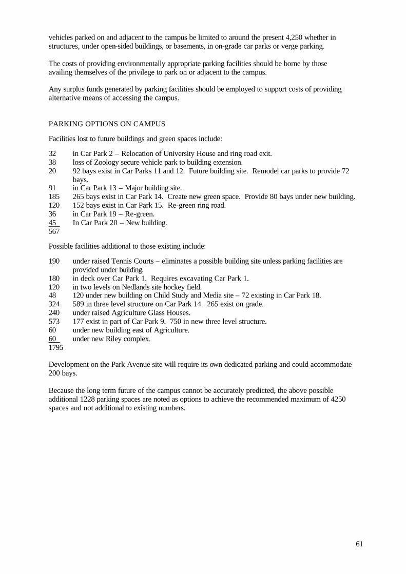
61
vehicles parked on and adjacent to the campus be limited to around the present 4,250 whether in structures, under open-sided buildings, or basements, in on-grade car parks or verge parking. The costs of providing environmentally appropriate parking facilities should be borne by those availing themselves of the privilege to park on or adjacent to the campus. Any surplus funds generated by parking facilities should be employed to support costs of providing alternative means of accessing the campus. PARKING OPTIONS ON CAMPUS Facilities lost to future buildings and green spaces include: 32 in Car Park 2 – Relocation of University House and ring road exit. 38 loss of Zoology secure vehicle park to building extension. 20 92 bays exist in Car Parks 11 and 12. Future building site. Remodel car parks to provide 72 bays. 91 in Car Park 13 – Major building site. 185 265 bays exist in Car Park 14. Create new green space. Provide 80 bays under new building. 120 152 bays exist in Car Park 15. Re-green ring road. 36 in Car Park 19 – Re-green. 45 In Car Park 20 – New building. 567 Possible facilities additional to those existing include: 190 under raised Tennis Courts – eliminates a possible building site unless parking facilities are provided under building. 180 in deck over Car Park 1. Requires excavating Car Park 1. 120 in two levels on Nedlands site hockey field. 48 120 under new building on Child Study and Media site – 72 existing in Car Park 18. 324 589 in three level structure on Car Park 14. 265 exist on grade. 240 under raised Agriculture Glass Houses. 573 177 exist in part of Car Park 9. 750 in new three level structure. 60 under new building east of Agriculture. 60 under new Riley complex. 1795 Development on the Park Avenue site will require its own dedicated parking and could accommodate 200 bays. Because the long term future of the campus cannot be accurately predicted, the above possible additional 1228 parking spaces are noted as options to achieve the recommended maximum of 4250 spaces and not additional to existing numbers.


63
PARKING OPTIONS ADJACENT TO CAMPUS The natural contours of the precinct between Fairway and Broadway north of Myers Street show a difference in level of three metres at Clark Street to six metres at Myers Street. By utilising these levels, up to 1500 vehicles could be accommodated below the level of Broadway and be accessed from Fairway between Cooper and Myers Streets: • The block between Cooper and Clark Streets could accommodate up to 250 vehicles in one level.
85 vehicles are already parked in Car Park 17. When this precinct is developed, the four existing car parks should be amalgamated with one large facility serving the whole site.
• The block between Clark and Edward Streets could accommodate up to 200 vehicles in one level. • Car Park 21 already accommodates 182 vehicles and could accommodate up to 420 vehicles.
• The block between Car Park 21 and Myers Street could accommodate 350 vehicles in one level or up to 700 in two levels.
Any of the above options adjacent to the campus would provide additional parking facilities with no loss to campus green spaces or potential building sites. However, there would be significant costs involved in purchasing those properties not already owned by the University. Some of these options would require forced ventilation but could accommodate buildings above. Development of the super blocks between Fairway and Broadway, whether under University ownership or other, will require dedicated parking. The properties in this precinct are subject to specific Local Authority (City of Subiaco) controls. Large concentrations of additional vehicles in this area will further increase the pressures on the district road system. Types of Parking Facilities: • On-grade parking: The bulk of campus facilities.
Car Park 3 is ideal, 346 bays slightly below ground level, well treed and penetrates to the inner pedestrian ways. Directly serves five buildings. Cost per vehicle – say 1100 X.
• Open undercroft parking: Example – Car Park 10 under Human Movement. Relatively small
facilities because of building footprint. Divorces building from ground level. Should not require a mechanical ventilation system. Retains building site. Does not impact on green spaces. Cost – say 9000 X.
• Basement parking under
buildings or even green spaces:
Example – Art Gallery and Myers Street building. Relatively small facilities because of building footprint. Requires a mechanical ventilation system. Retains building site. Does not impact on green spaces. If under say Tennis Courts or Glass Houses may not require mechanical ventilation. Cost – say 24000 X with mechanical ventilation.

underpass
underpass
crosswalk
crosswalk
unde
rpas
s
MatildaBay
MelvilleWater
FAIR W
AY
BR
OA
DW
AY
CLARK ST
EDWARD ST
COOPER ST
FAIR
WA
Y
BR
OA
DW
AY
STIRLING HIGHWAY
CLIFTO
N ST
GORDON ST
KA
NIM
BLA
RD
KARELLA ST
TA
REE
NA
ST
PARK RD
HA
MPD
EN
RD
LEU
RA
ST
HA
MPD
EN
RD
THE AVENUE
PRINCESS RD
EVERETT ST
CAPORN ST
COOK ST
MYERS ST
PAR
KW
AY
MOUNTS BAY ROAD
CRA
WLE
YA
VEN
UE
DRIVEANDREW'S
SAW
P RO
MEN
AD
E
GILLETT PRO
MEN
AD
E
IRW
IN S T
HA
CKETT
DRIVE
HA
CK
ETT
DR
IVE
PARK AVENUE
POOLEAV
WI N
TH
RO
P AV
EN
UE
MEG
ALO
NG
RD
outdoorlaboratory
TaxonomicGarden
PrescottCourt
tenniscourts
OakLawn
JamesOval
SunkenGdn Whelan
Court LawrenceJacksonCourt
SomervilleAuditorium
RileyOval
GreatCourt
WhitfeldCourt
Hampden Ent
Gordon Ent
Clifton Ent
Fairway Ent 2
Fairway Ent 1
Fairway Ent 3
Fairway Ent 4
Winthrop Ent
Hackett Ent 1
Hackett Ent 2
Hackett Ent 4
Hackett Ent 3
Parkway Ent 1
Parkway Ent 2
Parkway Ent 4
Parkway Ent 3
SERVICE ROADSEXISTING 2000
64
NORTH
P21
P15
P27
P14
P18P17
P20
P29
P30
P31
P34
P32
P9P10
P7
P8
P11
P12
P13
P6
P5
P4
P3
P2
P1
P23
P24
P26
P25
P22
P19
P33
LEGEND
SERVICE ROADS
65
• Multi-level dedicated
structures: A vertical concentration of large numbers of vehicles could free areas of the campus for future buildings or green spaces and would afford some measure of management efficiency but could cause traffic congestion at access points. Large structures can present security problems within the structure and for those accessing the structure from distant buildings. If the structures are above ground level, as could be achieved on Car Parks 9 and 14, the costs of mechanical ventilation can be avoided unless the structures are large in area. The structures have to be large to be viable and will eliminate large building sites or large green spaces unless the structures are below buildings. The structures would require some architectural embellishment to avoid having a negative effect on the quality of the built and landscaped environment of the campus. Cost – say 13,000 X to 20,000 X depending on architectural treatment.
The indicative cost ratios noted above are based on construction cost only and are independent of significant land values. Parking facilities under buildings share the land cost with the buildings. Facilities on-grade or in multi-level structures carry the whole land cost. The management and maintenance of 35 relatively small car parks on and adjacent to campus carries a cost. An argument for fewer, larger, decked car parks is in the elimination of some of the smaller facilities. Whatever form the car parks take they will not eliminate the network of campus roads required to provide general, security and emergency access to every building, nor the access and parking required for those with disabilities and the management of those access and parking facilities.

66
ACCESS In order to reduce the impact of parking facilities on the environment of the campus and of traffic movement on campus and on the adjacent neighbourhood roads, the University has pursued several alternative means of accessing the campus other than by private motor vehicles. The most promising of these alternatives is an efficient and convenient bus service, but success will be limited if the economic viability of public transport is undermined by a continual increase of parking facilities on and adjacent to the campus. Bus Service No. 78 Service The University negotiated a contract with the Department of Transport in 1994 for the No. 78 service that links the Wellington Street Bus and Railway Stations and the City Busport to the campus. The service was extended to public holidays and evenings in 1998. This service will terminate on the ring road at the new Riley Complex. Circle Route The Circle bus route Nos. 98 and 99 was launched in February 1999. This high frequency service operates between the Stirling Rail Station, QEII Medical Centre and the campus via the suburbs of Stirling, Balcatta, Innaloo, Floreat, Wembley, Jolimont, Daglish, Subiaco, Shenton Park and Karrakatta. It also links to Fremantle and Murdoch University and has proved popular with the community. Shuttle Buses Proposals in the 1975 “Recommendations to the Senate on Parking and Traffic” included a recommendation that a 2000 bay car park be established at Shenton Park linked to the campus by shuttle buses. This recommendation was not pursued but is a viable option for the future. A shuttle bus service which is to commence a 12 month trial period in January 2001, will link the Subiaco Railway Station and shopping precinct with the campus via the QEII Medical Centre. Ferry Service The University has been involved in an experimental ferry service from Applecross to the Nedlands foreshore in an attempt to stimulate interest in river access to the campus. This service did not prove to be financially viable but could succeed with Government or other support. The Ministry for Planning is investigating the establishment of a ferry service to link twenty sites around the river from Fremantle to Bayswater, including the Matilda Bay foreshore, which could satisfy a growing interest in this means of accessing the campus. Vehicle Pooling A proposal for two or more persons to share a vehicle has had limited success since its introduction in 1994 as has a 1999 offer of free parking for a limited number of pool vehicles.

67
Cycling Considerable attention has been given to encouraging staff and students to cycle to the campus with positive results. A survey in April 1999 showed a decrease in car usage and an increase in cycling and also public transportation usage. Approximately 40% of staff and students live within 9 kilometres of the campus which is considered to be within cycling range. A UWA Bicycle Users’ Group was established in 1998 to lobby for improved conditions for cyclists on and off campus including bicycle racks on buses and free transport of bicycles on trains in order to link transport options. Also secure storage for bicycles and shower and locker facilities for cyclists in new buildings such as the Riley Complex. Housing Approximately 500 staff and 3100 students live in Nedlands and Subiaco within walking distance of the campus. An increase in alternative types of residential facilities for both staff and students in the areas west of the campus to Broadway would increase this desirable ambulation. Unless the public transport system is greatly improved throughout the region, staff and students would still require the use of private transport so as not to become prisoners of the housing estate. The movement of such vehicles, presumably parked off campus, will still impact on the neighbourhood road system, but possibly not at peak times.
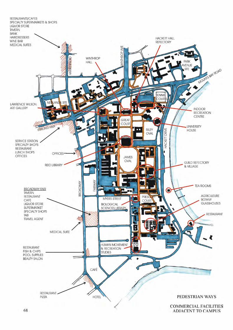

69
PEDESTRIANS Because of the low population densities, earlier campus plans utilised combined vehicular and pedestrian access ways. Later plans converted some of these traffic routes to pedestrian ways and developed the Stephenson principles of separating pedestrian and vehicle routes as shown in the 1990 and 1996 Development Plans (Illustrations Pages 24 and 26 respectively). Currently, some pedestrian ways also serve as vehicular ways, such as those on the south side of Winthrop Hall and east side of the Agriculture, Botany glasshouses. All pedestrian ways should be trafficable to carry occasional service and emergency vehicles. The major north-south pedestrian ways flanking Great Court and James Oval, established in the 1927 Wilkinson Plan and sanctified in the Stephenson Plans have been extended via the Stirling Highway and Mounts Bay Road underpasses to serve the College, Nedlands and Park Avenue sites. In the northern and middle precincts of the campus, concentrated groups of pedestrians are drawn to facilities such as the Indoor Recreation Centre, Hackett Hall Refectory, University House, Reid Library and the Guild Refectory and Village as well as their particular teaching and research destinations. The southern precinct is relatively underdeveloped in terms of general support facilities and has no food or commercial outlets. The Biological Sciences Library and also Human Movement and Recreational Studies exercise facilities draw pedestrians from the whole campus. Except for those south of Winthrop Hall and at Myers Street, east-west pedestrian ways are confined to internal campus movement. The Winthrop Hall pedestrian way links the western college sites via an underpass to the south deck of the Lawrence Wilson Art Gallery, Andrews Drive and then to the Octagon Theatre and existing University House. The Myers Street pedestrian way links Broadway and Fairway through Prescott Court to Hackett Drive. There is a need to improve pedestrian access from the Nedlands and Park Avenue sites to the campus proper. The network of pedestrian ways has been developed over a period of time and generally meets the requirements of pedestrian traffic and groups of pedestrians at gathering locations. Pedestrian ways are also used as cycle ways which can be hazardous or at least intimidating for pedestrians, because of the potential speed of the cycle which makes little noise. Pedestrian comfort would be enhanced by covered access ways, if only intermittent, to provide havens in inclement weather. A trend has developed for some students and staff to utilise off-campus commercial facilities in Broadway and Hampden Road and, to some extent, on the river foreshore, even for coffees and lunches. Such movement promotes a need for more prominent pedestrian entrances on the west and east flanks of the campus and well-defined pedestrian ways through the campus to the Broadway and Hampden Road facilities. This trend may be generated from a desire to escape academia or simply to enjoy a wider choice of facilities and could grow with the redevelopment of the Broadway strip. The utilisation of these off-campus facilities add to the integration of the University with the general community.

70
BUILDINGS No successful campus plan can be divorced from its third dimension. The plan is the mechanism by which facilities are located in their appropriate relationships. The success of the plan will be in response to the quality of these facilities, traffic and pedestrian systems, service systems, landscape and buildings. Apart from its superb landscape qualities, at least in the northern campus, the visual success of the Crawley campus is in the continuity of character, scale, texture and colour of its buildings. Individual buildings sacrifice their own unique identities in favour of the success of the whole campus. The 1930 Hackett Memorial buildings provided a space experience worthy of the Wilkinson structure plan and, with their romantic detailing, scale and rich palette of materials, set a formidable standard for subsequent building development to follow. Few university campuses have enjoyed such a monumental beginning and the majority of those that have cannot boast continuing success, the contextual qualities of their buildings being destroyed by the introduction of imported styles which ignore the benefits and constraints of local climates and conditions in favour of sculptural and sometimes gymnastic individuality. There are instances on the Crawley campus where individual and groups of buildings have departed from the character set by the Hackett buildings either by following fashions of the time or by naively mimicking the established building format. These blemishes illustrate that it is very much more difficult to procure a building of notable qualities in a contextual situation than in isolation. Whilst the acknowledged image of the campus built-form is of generally three-level, limestone coloured walled and red clay tiled roofed buildings there is a history of variations to this image. The first permanent building, for Biology and Geology, completed in 1925 was constructed in Neo Georgian style in two levels on what is now called the Park Avenue site and employed red clay brick walls with Donnybrook stone detailing and a red clay tile roof. The second permanent building, for Mining and Engineering, completed in 1927 was constructed in two and three levels immediately adjacent to Shenton House and employed red clay brick walls and red clay tile roof. The Hackett Memorial buildings, completed in 1930 and 31, were constructed in Mediterranean Romanesque style, with diversions, in one and two levels in monumental scale. Winthrop Hall, Tower and Administration buildings employed limestone walls and red clay tile roofs. The single level Hackett Hall employed rendered clay brick walls and flat concrete roof. The original Physics and Chemistry building, now Geology and Geography, constructed in 1935 in two-levels drew criticism from the Senate at the time because of the cost of repeating details and styling of the Hackett Memorial buildings. Tuart House constructed in 1934 in two levels as the first official residence for the University Vice Chancellor on the Park Avenue site employed red clay brick walls and red clay tile roof. The Institute of Agriculture building constructed in 1938 in two levels on the Southern campus employed cream clay brick walls, red clay tile roof and displayed many Art Deco influences.

71
University House (Staff Club) was the subject of an architectural competition in 1959. The design selected by an external jury imitated the style of the Hackett Memorial Buildings. The building was required to be redesigned. It is proposed to rebuild this facility on a new site. The 1961-65 Chemistry and 1961 Physics buildings were constructed in a minimalistic modern style of the 1960s with cream clay brick walls and flat concrete roofs. Although of a colour compatible with limestone, the scale of the texture of the clay bricks is out of context with that of limestone blocks. The flat roofs have not performed well in terms of storm water penetration and solar heat transmission. The 1961 flat roofed two-level Engineering Library and Lecture Theatre building displays external walls covered by mosaic tiles following a trend set by Mexico’s University City at that time. The character of the campus architecture was strengthened and unified with Gordon Stephenson’s influence on the design of the 1963 limestone walled Arts building, the 1964 Reid Library with precast exposed aggregate concrete panels, the 1967 Law School building with insitu “off-form” concrete walls and the 1968 Octagon Theatre with concrete block walls. All these and most subsequent buildings have employed red clay tile roofs and limestone coloured walls, whatever the wall material, increasing the unity and contextuality of the building stock. Relatively recent buildings for Mathematics, Electrical and Electronic Engineering and Computer Science (before relocation) employed cream clay brick walls. A perceived danger to the quality of the campus architecture is in complacency resulting in “inevitable” design solutions. A greater danger is in the possibility of stepping beyond the established character in pursuit of contemporary stylism. The image of a cloistered campus is strongest in the group of Hackett Memorial Buildings and to some extent the Geology Geography building and Physics building where some attempt has been made to link buildings with colonnades. The image is weakest where individual buildings have been located in isolation from their neighbours, usually in response to the particular funding system. The group, Law, Economics and Commerce, Social Sciences, Lecture Theatre and Student Guild, have been linked via a covered walkway system despite the individual buildings being constructed at quite different times. As well as facilitating protected access, the linking of various elements of groups of buildings reinforces the impression of totality and adds to the architectural experience of the campus.

underpass
underpass
crosswalk
crosswalk
unde
rpas
s
MatildaBay
MelvilleWater
FAI R
WA
Y
BR
OA
DW
AY
CLARK ST
EDWARD ST
COOPER ST
F AIRW
AY
BR
OA
DW
AY
STIRLING HIGHWAY
CLIFTO
N ST
GORDON ST
KA
NIM
BLA
RD
KARELLA ST
TAR
EE
NA
ST
PARK RD
HA
MP D
EN
RD
LEU
RA
ST
HA
MPD
EN R
D
THE AVENUE
PRINCESS RD
EVERETT ST
CAPORN ST
COOK ST
MYERS ST
PARK
WA
Y
MOUNTS BAY ROAD
CRA
WLE
YA
VE
NU
E
DRIVEANDREW'S
SAW
PRO
ME N
AD
E
GILLETT PR
OM
ENA
DE
IRW
IN ST
HACK
ETT
DRIV
E
HA
CK
ETT
DR
IVE
PARK AVENUE
POOLEAV
WIN
TH
RO
P AV
EN
UE
MEG
ALO
NG
RD
outdoorlaboratory
TaxonomicGarden
PrescottCourt
tenniscourts
OakLawn
JamesOval
SunkenGdn Whelan
Court LawrenceJacksonCourt
SomervilleAuditorium
RileyOval
GreatCourt
WhitfeldCourt
Hampden Ent
Gordon Ent
Clifton Ent
Fairway Ent 2
Fairway Ent 1
Fairway Ent 3
Fairway Ent 4
Winthrop Ent
Hackett Ent 1
Hackett Ent 2
Hackett Ent 4
Hackett Ent 3
Parkway Ent 1
Parkway Ent 2
Parkway Ent 4
Parkway Ent 3
HEIGHTS OFEXISTING BUILDINGS
72
LEGEND
SINGLE STOREY
TWO STOREYS
THREE STOREYS
FOUR STOREYS
FIVE OR MORE STOREYS
NORTH

73
HEIGHTS OF BUILDINGS The natural contours of the campus are generally level on the River frontage rising gently to the western Fairway boundary particularly in the north west corner of the campus at the junction of Fairway and Stirling Highway. Off campus the contours rise sharply to Broadway particularly at its intersection with Myers Street. Following historic and good general practice of constructing high buildings on high ground and low buildings on low ground, the 1915 Desbrowe-Annear campus plan located a concentration of “front door” buildings at the intersection of Fairway and what was then the Perth-Fremantle Road. Wilkinson’s 1926 and 27 plans relaxed the Desbrowe-Annear geometry but still contained the bulk of buildings on the Fairway and Perth-Fremantle Road higher flank of the campus. Stephenson’s 1955 plan provided a more balanced use of the whole campus but recommended a system of higher buildings on the higher ground. The height image of the campus is of three-storey buildings, but almost half of the building stock is two or single storey and a few four and more storeys. The three-storey building developed as a reasonable maximum height to climb stairs and to follow the principle of containing student movement to lower floor levels but now, because of the University’s policy to install passenger as well as goods lifts in all multi-level buildings, there is potential to explore buildings of a greater height. An increase in research and like facilities compared to undergraduate teaching facilities supports this height increase.
It is not possible (at this relatively short time in the growth of the University) to predict that the University can contain its population to the present size, or that technology will advance communications to the point where additional buildings will not be required. The campus plan must provide for the unpredictable as well as the predictable. Assuming that the future will require that the image of relatively low buildings set in landscaped courts be maintained and that additional buildings will be needed, what may be seen to be available space cannot be filled with car parks or used for purposes other than teaching or research. The “re-greening” of some areas of the campus which are below building and landscape standards of the northern campus will cause the loss of some car parking facilities and reduce the choice of building sites. Following the natural contours of the site and the format of earlier plans, the density of the campus accommodation can be increased by locating taller buildings on the western higher flank reducing to lower courtyard buildings on the eastern lower flank. The design and particular location of taller buildings will require sensitive handling as they will cast longer shadows causing soft landscape (which may not survive constant shadow) to be replaced by hard surfaces. This in itself could change the nature of the landscaped campus. It is tempting to prescribe building height limits across the campus, but this could constrain appropriate design solutions for particular developments.
Stephenson’s 1959 recommendation, that it was undesirable to make provision in buildings for undergraduate classes beyond the third level but, if necessary, space in upper levels of six or eight storey buildings could accommodate such facilities as staff offices and research laboratories, is still valid. Demolition of some of the older single and two level buildings will make some new sites available for buildings or green spaces, but the case for expanding the campus to Broadway and Fairway is strengthened.
74
LANDSCAPE The gardens of The University of Western Australia were adopted into the National Estate in 1980. The Campus was awarded the inaugural Western Australian Civic Design Award in 1986 for excellence in civic design. The University is part of a landscape of regional significance that includes Kings Park, the campus and adjacent Colleges, the Swan River and its foreshore. The generous open spaces that form the core of the campus give the grounds of the University their special quality. These spaces, as well as being beautiful in themselves, offer opportunities for meeting, playing, viewing, relaxing and contemplating. The landscaped courts allow the campus to breathe. They act as visual and physical extensions of spaces within the buildings. The large trees temper the microclimate by shading courts and building facades. An early history of the campus landscape: • Nyungar people occupied, managed and maintained links with the landscape in the vicinity of the
campus. The indigenous, self-propagated trees and the river are the remaining link with the pre-European landscape.
• The oldest Oaks of Oak Lawn are all that remain of the farming history of the site. Farming commenced around 1837 with clearing for pasture and the establishment of the Shenton House gardens among the naturally occurring wetlands, remnants of which persist at Pelican Point.
• Parts of the grounds were laid out in accordance with the Desbrow-Annear plan in 1925, accompanied by extensive planting of palms in the low lying wet areas and native trees around the oval.
• Somerville Auditorium was conceived in 1927. • An avenue of palms radiating from Winthrop Hall and trees and shrubs in formal arrangements
were planted around Hackett Hall in 1928-29. • The “Tropical Grove” of Great Court was planted in the 1930’s to hide a gardener’s shed and
yard. • The clever rehabilitation of a sand pit in 1945 resulted in the Sunken Garden. • The establishment of the present landscape continued after the 1950’s based on the Stephenson
plans of 1955 and 1962. The campus landscape of today is characterised by: • a generous tree canopy, both evergreen and deciduous. • large spreading fig trees and graceful eucalypts. • remnant indigenous trees representative of a pre-European landscape. • expansive open green spaces. • semi-secluded courtyards. • an inner pedestrian precinct relatively free from motor vehicles. • carparks of varying size and landscape quality – generally on the perimeter. • generally, native evergreen trees on the perimeter with exotic planting in the core. • a river presence with river views. • buildings of moderate scale with, generally, a consistency of form, scale, colour and materials. • a consistency of materials and quality in paving and furniture. • abundant and sometimes exotic birdlife. • a large, mainly youthful human population.

75
Paving is a major component of the campus landscape. The original paving materials included grey 610 x 610 concrete slabs and red pressed clay bricks for pedestrian ways and black bitumen for roads and carparks. Insitu cream concrete with terracotta patterning was introduced in the 1970’s to replace bitumen roads beside Whitfeld Court and south of Winthrop Hall. In the 1980’s the palette expanded to include high performance red wire-cut clay bricks (around James Oval); limestone coloured concrete “cobblestones” (Irwin Street); small setts to match the cobblestones (south of Geography); and interlocking pavers (Carpark 11). The search was for a pavement that was appropriate for pedestrians but also capable of carrying heavy motor vehicles. The current palette consists of black bitumen for high vehicle use roads and car parks, concrete paving blocks of clay brick dimension for trafficable pedestrian ways, 400 x 400 concrete paving slabs for courtyards and pedestrian areas carrying lighter vehicle traffic, and concrete cobblestones in certain situations. Unit paving, as opposed to insitu paving, facilitates removal and replacement to allow access to underground services. Wherever possible services are located under paving to avoid disruption of the shrinking soft landscape. The major landscape issues are: • Large trees are a most important component of the campus landscape and large trees require
space. Increased building density will continue to result in a reduction of open space. • Shading from increased building heights and wear from increased people traffic is leading to a
hardening of ground surfaces. • Increasing parking facilities would reduce the opportunity to reclaim green spaces. • There is an imbalance in open space provision and landscape quality between the northern, middle
and southern precincts of the campus. • The southern precinct enjoys only one large open space, the Human Movement Outdoor
Laboratory. This space is used for teaching and research purposes that preclude large trees. There is a need for at least one other large open space within the southern campus.
• The character and quality of the Nedlands and Park Avenue sites are not of the standard of the main campus.
• Aging trees (especially self-sown introduced eucalypts) discard limbs and are becoming a hazard. Such trees should be progressively removed and replaced with more suitable species.
• The final alignment of the ring road on the southern edge of the campus may conflict with the preservation of a stand of native trees with links to the pre-European landscape.
The principal threat to the quality of the campus landscape is the increasing pressure being placed on the green open spaces. In order that the existing landscape character and quality of the Campus be retained - and extended to the southern campus and Nedlands – certain strategies should be followed: • Establish defined boundaries to the existing Permanent Green Reserves. It may be necessary to
impose height limits to buildings neighbouring on the Permanent Green Reserves to prevent excessive shading.
• Dedicate a large open space in the southern campus as a Permanent Green Reserve. This should be in addition to any area set aside for the Human Movement Outdoor Laboratory. Dedicate the “Great Court” at Nedlands as a Permanent Green Reserve.
• Accept that there will be increased hardening of the landscape in the vicinity of buildings and on major pedestrian routes, the strategy being to provide hard wearing surfaces where needed, thereby taking the pressure off the green spaces.

underpass
underpass
crosswalk
crosswalk
unde
rpas
s
MatildaBay
MelvilleWater
FAI R
WA
Y
BR
OA
DW
AY
CLARK ST
EDWARD ST
COOPER ST
F AIRW
AY
BR
OA
DW
AY
STIRLING HIGHWAY
CLIFTO
N ST
GORDON ST
KA
NIM
BLA
RD
KARELLA ST
TAR
EE
NA
ST
PARK RD
HA
MP D
EN
RD
LEU
RA
ST
HA
MPD
EN R
D
THE AVENUE
PRINCESS RD
EVERETT ST
CAPORN ST
COOK ST
MYERS ST
PARK
WA
Y
MOUNTS BAY ROAD
CRA
WLE
YA
VE
NU
E
DRIVEANDREW'S
SAW
PRO
ME N
AD
E
GILLETT PR
OM
ENA
DE
IRW
IN ST
HACK
ETT
DRIV
E
HA
CK
ETT
DR
IVE
PARK AVENUE
POOLEAV
WIN
TH
RO
P AV
EN
UE
MEG
ALO
NG
RD
outdoorlaboratory
TaxonomicGarden
PrescottCourt
tenniscourts
OakLawn
JamesOval
SunkenGdn Whelan
Court LawrenceJacksonCourt
SomervilleAuditorium
RileyOval
GreatCourt
Child StudyCentre
P9
P14
WhitfeldCourt
Hampden Ent
Gordon Ent
Clifton Ent
Fairway Ent 2
Fairway Ent 1
Fairway Ent 3
Fairway Ent 4
Winthrop Ent
Hackett Ent 1
Hackett Ent 2
Hackett Ent 4
Hackett Ent 3
Parkway Ent 1
Parkway Ent 2
Parkway Ent 4
SewagePumping
Station
Parkway Ent 3
SERVICE EASEMENTS
76
LEGEND
PRIMARY SERVICEEASEMENT
SECONDARY SERVICEEASEMENT
SERVICES NOT INEASEMENT
PROPOSED EXTENSIONTO EASEMENT
NORTH

77
SERVICES SERVICE CORRIDORS The early campus plans developed a planning structure on a basic rectangular grid which made possible a simple underground service corridor system breaking the campus into manageable groups of facilities. Generally the majority of services have followed the corridor system but a few primary and several secondary services have found their own more economical routes between buildings. Some service corridors have been breached by buildings, which may be acceptable in certain locations and all are penetrated by roads, car parks and landscaping in various places. The corridors vary in width depending on the number and status of the services accommodated. Few have much spare capacity for future services and natural ground levels in some zones do not favour the falls required for sewer and stormwater outfall. The corridor system facilitates the looping of services such as electricity, chilled water, domestic and fire water and gas so that supply is maintained should one part of a loop be broken. CHILLED WATER Reticulated chilled water for air conditioning is supplied throughout the campus from a Central Plant in Car Park 14. An experimental chilled water storage tank was constructed on the chilled water ring main adjacent to Car Park 9 early in 1998. The aim was to chill the tank water out of electricity peak hours and circulate the water during peak hours and also to avoid the need to increase the size of the established chilled water ring main system which is otherwise inadequate to serve the unexpected demand. An additional chilled water storage facility is required in the Northern Precinct. The Child Study Centre/Media Services site has been identified as an appropriate location for this facility. Expansion into the areas west of the campus will require additional plant and/or storage tanks. PARKWAY A reticulation sewer rises from a pumping station to the north in Parkway and turns to the west at Caporn Street. Other reticulation sewers fall to the west towards Broadway at the rear of properties. A stormwater drain falls to the south in Parkway. The Parkway road reserve services include electricity, telephone and gas. COOPER AND CLARK STREETS A reticulation sewer falls north down to south at the rear of properties between Broadway and Fairway. Gas, domestic water and stormwater drain run east west in Cooper Street. Gas and domestic water run east west in Clark Street.

underpass
underpass
crosswalk
crosswalk
unde
rpas
s
MatildaBay
MelvilleWater
FAI R
WA
Y
BR
OA
DW
AY
CLARK ST
EDWARD ST
COOPER ST
F AIRW
AY
BR
OA
DW
AY
STIRLING HIGHWAY
CLIFTO
N ST
GORDON ST
KA
NIM
BLA
RD
KARELLA ST
TAR
EE
NA
ST
PARK RD
HA
MP D
EN
RD
LEU
RA
ST
HA
MPD
EN R
D
THE AVENUE
PRINCESS RD
EVERETT ST
CAPORN ST
COOK ST
MYERS ST
PARK
WA
Y
MOUNTS BAY ROAD
CRA
WLE
YA
VE
NU
E
DRIVEANDREW'S
SAW
PRO
ME N
AD
E
GILLETT PR
OM
ENA
DE
IRW
IN ST
HACK
ETT
DRIV
E
HA
CK
ETT
DR
IVE
PARK AVENUE
POOLEAV
WIN
TH
RO
P AV
EN
UE
MEG
ALO
NG
RD
outdoorlaboratory
TaxonomicGarden
PrescottCourt
tenniscourts
OakLawn
JamesOval
SunkenGdn Whelan
Court LawrenceJacksonCourt
SomervilleAuditorium
RileyOval
GreatCourt
WhitfeldCourt
Hampden Ent
Gordon Ent
Clifton Ent
Fairway Ent 2
Fairway Ent 1
Fairway Ent 3
Fairway Ent 4
Winthrop Ent
Hackett Ent 1
Hackett Ent 2
Hackett Ent 4
Hackett Ent 3
Parkway Ent 1
Parkway Ent 2
Parkway Ent 4
Parkway Ent 3
LAND HOLDINGS REQUIREDFOR MINIMAL EXPANSION
78
NORTH
LEGEND
LOTS REQUIRED FORMINIMAL EXPANSION
UNIVERSITY HOLDINGS 2000

79
UNIVERSITY OWNED PROPERTIES ADJACENT TO THE CAMPUS Since 1964 the University has been acquiring properties off campus in the areas between Stirling Highway, Fairway, Myers Street and Broadway and also between Myers Street, Parkway, Princess Road and Fairway. Most of these properties were purchased. Some were bequeathed to the University. Initially the intent was to own all neighbouring properties fronting Fairway, Myers Street and Parkway in order to control usage and interaction between University and adjacent private properties. When the need for campus expansion was identified, the University spread its interest to acquiring any property in the two areas, subject of course to value. The pattern of acquisition was to accumulate properties in blocks to facilitate redevelopment as it was realised that the University may never own all properties in these areas and in fact may not need to own all. Over a 36-year period the University has acquired approximately 50% of the subject properties and presumably could acquire many more in the next 36 to 50 years. With zoning and other controls sympathetic to the needs of the University, the benefits of expansion west to Broadway include being able to continue the basic pedestrian and major green space campus structure into the southern campus, to protect the main campus qualities from the effects of overbuilding, to extend the campus green space system into the expansion areas and to develop off campus facilities which interface with the general community. The acquisition of a few particular properties additional to those already owned by the University would be adequate as a first stage to extend the campus structural layout and provide new sites for buildings and green spaces and to at least establish a structure plan for the whole site from Hackett Drive to Broadway. This could be a very long-term venture as the required properties can only be acquired when they become available for purchase. The expansion path recommended in this Review is a principle only and may have to be revisited to suit the availability and affordability of particular properties.
80
RECOMMENDATIONS This section contains recommendations for the progressive long-term development of the campus. These are shown via a series of structural diagrams dealing with the major planning issues – the environmental qualities of the campus, potential building sites, pedestrian routes, parking and green spaces. Three options have been presented: PREFERRED OPTION 1 explores the possibilities presented by expanding the campus west of Fairway to Broadway (north of Myers Street) and west of Parkway to Fairway (south of Myers Street). Expansion of the campus, in some form, is inevitable even if in the long-term. The expansion structure illustrated relies on the availability of particular properties and may require adjustment if these properties are not available for purchase or are not affordable. Option 1 relies on the closure of a section of Parkway. OPTION 2 is based on the principles of Option 1 but presents one of several alternative structures if Parkway cannot be closed or if particular properties cannot be acquired. OPTION 3 illustrates the constraints which would be imposed on the campus if long-term future development was contained within the present boundaries of the campus. NOTIONAL TOTAL DEVELOPMENT PLAN presents a possible long-term total development of the areas between Fairway and Broadway and Parkway and Fairway and is intended only to illustrate the principles on which the proposed campus expansion is based.

WINTHROPENTRANCE
EASTENTRANCE
CAMPUS STRUCTUREEXISTING 200081
STUDENT GUILDADMINISTRATION&TAVERN
BIOLOGICALSCIENCESLIBRARY
HUMANMOVEMENT
ZOOLOGY
BIOCHEMISTRY
REID LIBRARY
ADMINISTRATION
UNIVERSITYHOUSE
NEDLANDS SITE
PARK AVENUESITE
COLLEGES
MOUNTS BAY ROAD
WIN
THR
OP
AV
EN
UE
STIRLING HWY
COLLEGES
MatildaBay
MelvilleWater
JAMES OVAL
MYERS STREET
ENGINEERING
PRINCESS ROAD
RILEYOVAL
OAKLAWN
LAWCAR PARK 3
FAIRWAYENTRANCE
NO. 1
HACKETT ENTRANCE
NO. 2
GREATCOURT
GIL
LETT
PR
OM
EN
AD
E
SA
W A
VE
NU
E
BR
OA
DW
AY
FAIR
WA
Y
PA
RK
WA
Y
HA
CK
ETT
DR
IVE
WHITFELDCOURT
SUNKENGARDEN
PRESCOTTCOURT
SOMERVILLEAUDITORIUM
OUTDOORLABORATORY
LEGEND
CAMPUS CARPARKSAND ROADS
FOOTPATHS
GREEN SPACES
EXISTING BUILDINGS
PROPOSED BUILDINGS
NORTH
82
CAMPUS STRUCTURE – EXISTING 2000 The historic and main campus vehicular entrance is located at the intersection of Winthrop Avenue and Stirling Highway. The Hackett Memorial Buildings and Whitfeld Court signal the ethos of the campus and accommodate Administration facilities. The Student Guild originally located in Hackett Hall is now located in the centre of the eastern flank of the campus and is well placed to serve the whole campus. An eastern vehicular entrance of some significance penetrates to the inner pedestrian system at the Reid Library via Car Park 3. This entrance will be enhanced by the relocation of University House to the new Riley Complex at the southern edge of Riley Oval. The Reid Library is central to the northern and middle precincts but relatively remote from the southern precinct. The Biological Sciences Library expanded to become the Sciences Library will compensate this imbalance. The twin north-south internal pedestrian ways – Gillett and Saw Promenades – flank the three major green spaces, the eastern leg continuing south to Human Movement, the western leg terminating at the Myers Street constriction. The beginnings of another north-south pedestrian way runs from Car Park 3 on the east side of Law but terminates at the Guild Tavern. A campus ring road runs north from Fairway Entrance 1 to south of Hackett East Entrance 2 adjacent to Biochemistry. This ring road is one-way between Winthrop Entrance and existing University House. Sections of a continuous ring road exist east of Zoology, south of Human Movement and west of Engineering and Electrical Engineering. The Park Avenue site is fragmented and has no ordered structure. The Nedlands site is following a simple structure plan. The major campus green spaces identified and protected are:
Sunken Garden Whitfeld Court Great Court James Oval Somerville Auditorium Riley Oval (reduced) Oak Lawn Prescott Court Human Movement Outdoor Laboratory Other green spaces of note include: Lawrence Jackson Court Taxonomic Gardens Agriculture Courts Zoology Court Nedlands Court

LOCATION A
LOCATION B
WESTENTRANCE
EASTENTRANCE
LAW
HACKETT DRIVE
MOUNTS BAY ROAD
STIRLING HWY
BR
OA
DW
AY
FAIR
WA
Y
PRINCESS ROAD
PA
RK
WA
Y
HA
CK
ETT
DR
IVE
MYERS ST
CAPORN ST
COOK ST
EVERITT ST
EDWARD ST
OPTION 1DEVELOPMENT
EXPANDED CAMPUS83
STUDENT GUILDADMINISTRATION
BIOLOGICAL SCIENCESLIBRARY
REID LIBRARY
ADMINISTRATION
WHITFELDCOURT
RILEYOVAL
GREATCOURT
SOMERVILLEAUDITORIUM
JAMES OVAL
OAKLAWN
PRESCOTTCOURT
SUNKENGARDEN
NEDLANDS SITE
COOPER STSHOWN DOTTED
COLLEGES
MatildaBay
MelvilleWater
PARK AVENUESITE
COLLEGES
OUTDOORLABORATORY
AGRICULTURE
ZOOLOGY
NORTH
SOUTH ENTRANCE
WINTHROPENTRANCE

84
OPTION 1 DEVELOPMENT – EXPANDED CAMPUS CAMPUS STRUCTURE • Acquire particular off-campus properties in locations, A and B to add to those already owned by
the University to facilitate, at least, some minimal expansion of the campus in these locations. If viable, continue to acquire properties adjacent to the campus boundaries and particularly in selected groups to facilitate appropriate redevelopment.
• Form a working party with the City of Subiaco and the Western Australian Planning Commission
to pursue an amendment to Council’s Town Planning Scheme No. 4 in the relevant precincts west of the campus to Broadway. Secure land use zoning and other control mechanisms compatible with appropriate redevelopment of these precincts.
• Negotiate controls adequate to compensate the cost of providing landscaped spaces. • Close Parkway between Myers Street and Caporn Street. Absorb road reserve. Cook Street is
already closed to Parkway – reduce length. Open Everett Street to Parkway. Note, amalgamation of some properties with the campus may be required if buildings are to straddle the campus boundary.
• In Location B, extend campus planning structure to provide a major green space and building sites.
• As properties are acquired and developed:
Extend the western north-south pedestrian way (Gillett Promenade) to, at least, the properties between Caporn and Everett Streets. Extend the east-west pedestrian ways to Broadway north of Myers Street and to Fairway south of Myers Street. Extend the east-west pedestrian way south of the expanded Biological Sciences Library to link Fairway and Hackett Drive.
• Explore examples of redevelopment of properties in the expansion zones to achieve continuity
between these zones and the main campus. • Close Cooper Street between Broadway and Fairway. Absorb road reserve.
Explore third level bridge connection between new development in Location A and the Nedlands site utilising lifts and escalators to connect to the main body of the campus.
• Extend north-south pedestrian way east of Law to development in the south-east corner of the
campus and southern entrance. • Create western landscaped pedestrian entrance to the campus at Edward Street. NOTE: Closing Cooper Street is not necessary to the development of the properties in Location A. The closure is desirable to utilise the full potential of the University’s holdings. Some services in the Cooper Street road reserve may need to be terminated or relocated. Closing Parkway, retaining services below a major green space and building over these services would require the cooperation of the Utilities Departments. Should building over the services prove not to be viable, services such as stormwater drains might be diverted provided the required falls can be achieved. A reticulation sewer rises to the north up Parkway and turns west into Caporn Street. A stormwater drain falls to the south in Parkway.
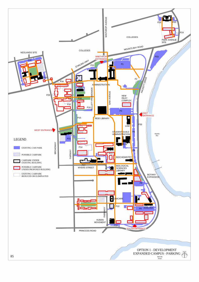
OPTION 1 - DEVELOPMENTEXPANDED CAMPUS - PARKING
85
NORTH
REID LIBRARY
ADMINISTRATION
NEWRILEYCOMPLEX
NEDLANDS SITE
COLLEGES
MOUNTS BAY ROAD
WIN
THR
OP
AV
EN
UE
STIRLING HWY
COLLEGES
MatildaBay
MelvilleWater
MYERS STREET
PRINCESS ROAD
LAW
P21
P14
P15
P13
P15
P27
P20
P30
P31
P9P10
P8
P6
P5
P4
P35
P3
P16P32
P29
P34
P18
P1
P23
P2
P22
P33SOUTH ENTRANCE
WINTHROPENTRANCE
EASTENTRANCE
WEST ENTRANCE
LEGEND
EXISTING CAR PARK
POSSIBLE CARPARK
CARPARK UNDEREXISTING BUILDING
POSSIBLE CARPARKUNDER PROPOSED BUILDING
EXISTING CARPARKREDUCED OR ELIMINATED
P26 P25
P24
STUDENT GUILDADMINISTRATION
BIOLOGICALSCIENCESLIBRARY
HUMANMOVEMENT
ZOOLOGY
BIOCHEMISTRY
UNICARE
PARK AVENUESITE
BOTANYEXPANSION
GIL
LETT
PR
OM
EN
AD
E
SA
W A
VE
NU
E
BR
OA
DW
AY
FAIR
WA
Y
PA
RK
WA
Y
HA
CK
ETT
DR
IVE

86
OPTION 1 DEVELOPMENT – EXPANDED CAMPUS TRAFFIC, PARKING AND ACCESS As redevelopment permits, reduce parking spaces to around 2,000 on the main body of the campus; reduce to a total of around 3,000 including Car Park 23, the Nedlands and redeveloped Park Avenue sites and expanded Car Park 21; and maintain the existing total of around 4,250 including adjacent road verge parking. Options include: • Retain Car Parks 1, 3, 4, 5, 6, 10, 16, 22, 23, 27, 28, 30, 31 and 35 1,664
and Car Parks 17, 24, 25, 26, 29, 32, 33 and 34 until sites are redeveloped. 208 • Provide parking under new Riley Complex. 60
under new building east of Agriculture. 60 west of Parkway for Unicare. 30 under new development across Parkway. 200 in two-level structure on Nedlands site. 120 with development on the Park Avenue site. 200 under raised glasshouses in Southern Campus. 240
• Rebuild Car Park 8 to accommodate Botany expansion. 100 • Reduce Car Park 9. Provide parking under new development. 300 • Reduce Car Park 14. Provide parking under new development.
(Note: this site could accommodate a multi-level structure if all else fails.) 80 ring road Car Park 15 for re-greening. 32
Car Park 18. Provide parking under new building. 120 Car Park 20 to accommodate new Museum building 111 • Extend Car Park 21 at Edward Street 420 3,945 Verge parking in adjacent streets. 63 spaces would be lost with the closure 704 of part of Parkway. 4,649 This number of 4,649 spaces relates to a comparable number of 4,236 spaces existing at the time of this Review. The 399 spaces above the recommended 4,250 spaces allow some tolerance in option selection. Others will arise as building programmes are developed. • Avoid the concentration of vehicles in multi-level car parks on the main campus.
Consider naturally ventilated car parks under new buildings where appropriate and ground levels permit.
• Minimise the number of vehicles penetrating the inner pedestrian precincts of the campus. • Complete the campus ring road system utilising Parkway, Everett and Caporn Streets and sections
of Fairway as part of the ring road. • Reinstate two-way traffic on the ring road between the Winthrop Entrance and existing University
House site. Relocate the Tennis Courts ring road exit at Hackett Drive to the site of the existing University House.
• Continue to pursue means of accessing the campus other than by private motor vehicles. • Provide easily identifiable and protected bus and taxi stops at prominent locations.
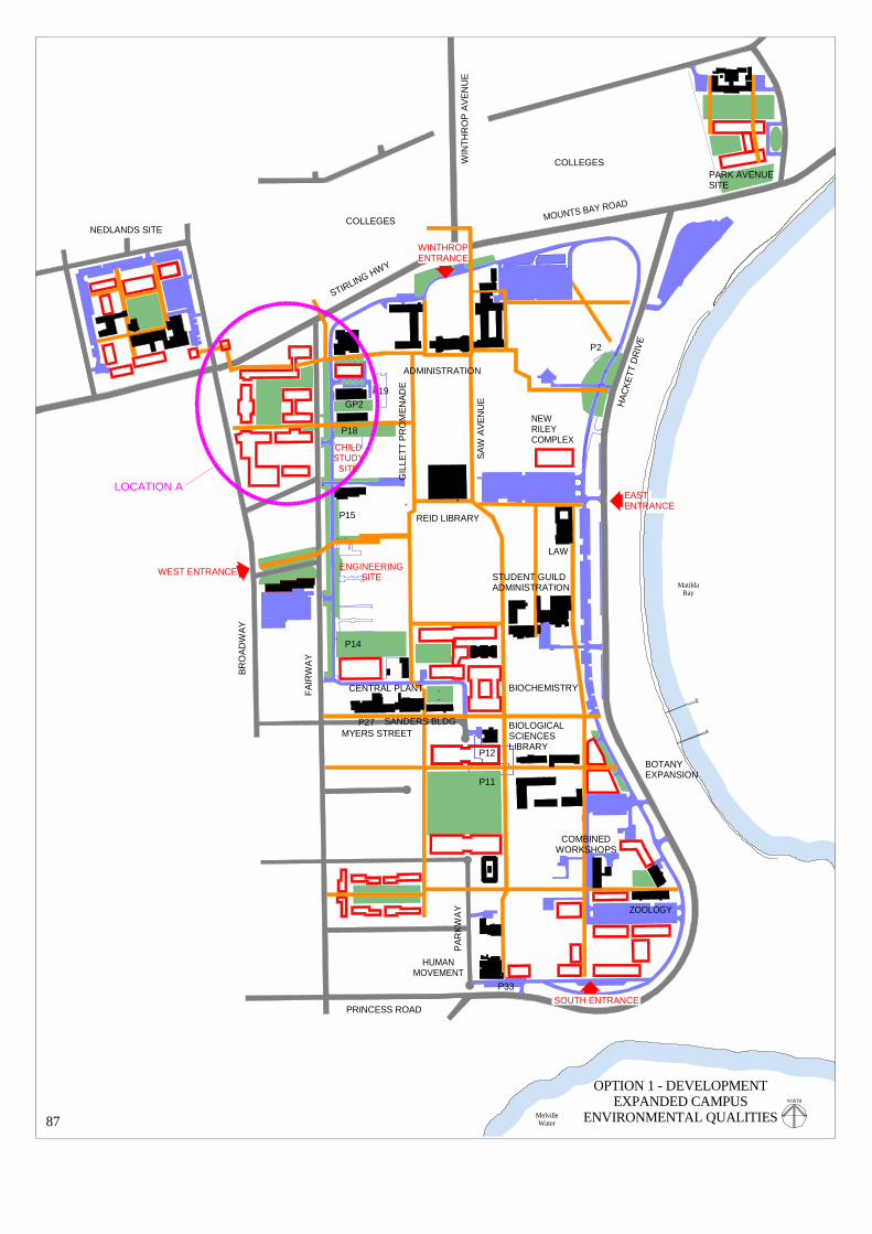
ENGINEERINGSITE
P14
P15
P12
P11
P15
P27
P18
P2
P19GP2
P33SOUTH ENTRANCE
WINTHROPENTRANCE
EASTENTRANCE
WEST ENTRANCE
OPTION 1 - DEVELOPMENTEXPANDED CAMPUS
ENVIRONMENTAL QUALITIES87
NORTH
REID LIBRARY
ADMINISTRATION
NEWRILEYCOMPLEX
NEDLANDS SITE
COLLEGES
MOUNTS BAY ROAD
WIN
THR
OP
AV
EN
UE
STIRLING HWY
COLLEGES
MatildaBay
MelvilleWater
MYERS STREET
PRINCESS ROAD
SANDERS BLDG
LAW
LOCATION A
CHILDSTUDY
SITE
STUDENT GUILDADMINISTRATION
BIOLOGICALSCIENCESLIBRARY
HUMANMOVEMENT
ZOOLOGY
BIOCHEMISTRY
PARK AVENUESITE
BOTANYEXPANSION
CENTRAL PLANT
COMBINEDWORKSHOPS
GIL
LETT
PR
OM
EN
AD
E
SA
W A
VE
NU
E
BR
OA
DW
AY
FAIR
WA
Y
PA
RK
WA
Y
HA
CK
ETT
DR
IVE

88
OPTION 1 DEVELOPMENT – EXPANDED CAMPUS
ENVIRONMENTAL QUALITIES • Maintain the established character of courtyarded low-scaled buildings set in an open landscaped
campus. • Maintain the contextual qualities of the campus buildings. • When opportunities arise address the imbalance between the character and qualities of the
northern, middle and southern campus precincts by reducing the impact of some car parks . • Eliminate Car Park 2 with relocation of University House to the new Riley Complex and
landscape. • Eliminate Car Parks 11 and 12. Redevelop with major green space. • Reduce size of Car Park 14. Landscape strip north of Central Plant and future building. • Reduce extent of ring road Car Park 15. Maintain and landscape ring road. • Reduce size of Car Park 18. Landscape strip south of General Purpose building. • Eliminate Car Park 19 except for services access and create landscaped courtyard. • Demolish shed north of Sanders Building. Create landscaped court. • Demolish part of middle wing of existing Chemistry when vacated and provide landscaped court. • Create major landscape space between Botany, Zoology and Combined Workshops. • Formalise central landscaped court on the Nedlands site. • Create an internal landscaped court on the Park Avenue site when site is redeveloped. • Create internal landscaped courts in new development in Location A as extensions of the main
campus green spaces. • Explore landscaped links between the main campus and expansion zones. • Confine taller buildings to the higher ground on the Fairway flank of the campus but avoid a
continuous wall of tall buildings. Appropriate sites: Car Park 14; Engineering site; Child Study /Media Services site
• Provide maximum flexibility in new buildings to allow for growth and contractions of departments
and changes in discipline groupings. • Limit the concentration of public facilities in the northern campus precinct. Disperse these
facilities, especially to the southern campus precinct. • Utilise the site in the south-east corner of the campus for a prominent group of buildings with the
qualities, presence and community interface of the Hackett Memorial Buildings. • Prepare a Campus Conservation Plan. Acknowledge the indigenous heritage of the campus site
and address the maintenance of the campus buildings and spaces of historic significance.

BOATS
HEDS
SITETENNIS
COURTSSITE
ENGINEERINGSITE
P14
P15
P18
P13
P15
P27
P18
P19GP2
P23
P3
P20
P33
P9
SOUTH ENTRANCE
WINTHROPENTRANCE
EASTENTRANCE
WEST ENTRANCE
OPTION 1 - DEVELOPMENTEXPANDED CAMPUS
BUILDING SITES89
NORTH
REID LIBRARY
ADMINISTRATION
NEWRILEYCOMPLEX
NEDLANDS SITE
COLLEGES
MOUNTS BAY ROAD
WIN
THR
OP
AV
EN
UE
STIRLING HWY
COLLEGES
MatildaBay
MelvilleWater
MYERS STREET
PRINCESS ROAD
SANDERS BLDG
LAW
LOCATION C
LOCATION A
CHILDSTUDY
SITE
STUDENT GUILDADMINISTRATION
HUMANMOVEMENT
ZOOLOGY
PARK AVENUESITE
CENTRAL PLANT
CHEMISTRY
AGRICULTURE
PRESCOTTCOURT
BOTANY
ANIMALHOUSE
GIL
LETT
PR
OM
EN
AD
E
SA
W A
VE
NU
E
BR
OA
DW
AY
FAIR
WA
Y
PA
RK
WA
Y
HA
CK
ETT
DR
IVE

90
OPTION 1 DEVELOPMENT – EXPANDED CAMPUS BUILDING SITES • Retain Tennis Courts site for expansion of Music but consider relocation of Music in long term. • Explore Boatsheds Site for University/community riverfront development. • Provide site for Museum building in Car Park 20. • Construct new Riley Complex on Riley Oval adjacent to Car Park 3. • Redevelop Child Study Centre/Media Services site for major building. Include chilled water
storage facility. Possible high building (six to eight floors). • Redevelop Engineering site. Possible high building (six to eight floors). • Construct new building on Car Park 14 site adjacent to Central Plant. Possible high building (six
to eight floors). • Eliminate Car Park 13 to provide major building site. (Science Building) • Demolish northern wing of existing Chemistry when vacated and provide major building site. • Demolish southern wing of existing Chemistry when vacated and provide building site. • Demolish remnants of Old Pharmacology building and minor structures east of Agriculture.
Redevelop as prominent building site. Protect Prescott Court and maintain river views. • Provide major building sites north and south of new major green space at Parkway closure. • Develop linking extension between Botany and Zoology. • Relocate Zoology secure car park to Shenton Park to provide building site. • Demolish existing large animal house and provide building site for new animal house. • Develop south-east corner of campus including portion of Car Park 9 as major and prominent
building site. • Provide site for Human Movement expansion at Car Park 33. • Develop Nedlands site with new buildings on north and south flanks to enclose an internal
landscaped court. • Develop Park Avenue site to complement 1925 Biology Geology building and to enclose an
internal landscaped court. • Develop properties in Location A for University/community use. • Develop an example of residential buildings enclosing a communal landscaped court on properties
owned by the University in Location C between Caporn and Everett Street

91
PREFERRED OPTION 1 DEVELOPMENT PLAN – EXPANDED CAMPUS
The development plan shown overleaf (adjacent to the existing plan to facilitate comparison) seeks to incorporate all of the recommendations made by this Review. It is proposed as a guide for all future development of the campus.

underpass
underpass
crosswalk
crosswalk
unde
rpas
s
MatildaBay
MelvilleWater
FAI R
WA
Y
BR
OA
DW
AY
CLARK ST
EDWARD ST
COOPER ST
F AIRW
AY
BR
OA
DW
AY
STIRLING HIGHWAY
CLIFTO
N ST
GORDON ST
KA
NIM
BLA
RD
KARELLA ST
TAR
EE
NA
ST
PARK RD
HA
MP D
EN
RD
LEU
RA
ST
HA
MPD
EN R
D
THE AVENUE
PRINCESS RD
EVERETT ST
CAPORN ST
COOK ST
MYERS ST
PARK
WA
Y
MOUNTS BAY ROAD
CRA
WLE
YA
VE
NU
E
DRIVEANDREW'S
SAW
PRO
ME N
AD
E
GILLETT PR
OM
ENA
DE
IRW
IN ST
HACK
ETT
DRIV
E
HA
CK
ETT
DR
IVE
PARK AVENUE
POOLEAV
WIN
TH
RO
P AV
EN
UE
MEG
ALO
NG
RD
outdoorlaboratory
TaxonomicGarden
PrescottCourt
tenniscourts
OakLawn
JamesOval
SunkenGdn Whelan
Court LawrenceJacksonCourt
SomervilleAuditorium
RileyOval
GreatCourt
WhitfeldCourt
Hampden Ent
Gordon Ent
Clifton Ent
Fairway Ent 2
Fairway Ent 1
Fairway Ent 3
Fairway Ent 4
Winthrop Ent
Hackett Ent 1
Hackett Ent 2
Hackett Ent 4
Hackett Ent 3
Parkway Ent 1
Parkway Ent 2
Parkway Ent 4
Parkway Ent 3
EXISTING PLAN 2000
92
NORTH
P21
P15
P27
P14
P18P17
P20
P29
P30
P31
P34
P32
P9P10
P7
P8
P11
P12
P13
P6
P5
P4
P3
P2
P1
P23
P24
P26
P25
P22
P19
P33
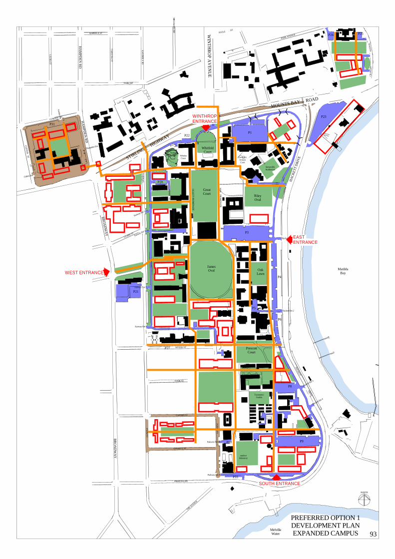
underpass
underpass
crosswalk
cro sswalk
und e
rpas
s
MatildaBay
MelvilleWater
F AIRW
AY
BR
OA
DW
AY
CLARK ST
FAIRW
AY
BR
OA
DW
AY
STIRLING HIGHWAY
CLIFTO
N ST
GORDON ST
KA
NIM
BLA
RD
KARELLA ST
TA
RE
EN
A ST
PARK RD
HA
MP D
EN
RD
LE
UR
A ST
HA
MPD
EN
RD
THE AVENUE
PRINCESS RD
EVERETT ST
CAPORN ST
COOK ST
MYERS ST
PAR
KW
AY
MOUNTS BAY ROAD
CR
AW
LEY
AV
ENU
E
DRIVEANDREW'S
SAW
PRO
ME N
AD
E
GILLETT P R
OM
ENA
DE
IRW
IN ST
HACK
ETT
DRIVE
HA
CK
ETT
DR
IVE
PARK AVENUEPOOLE AV
WIN
TH
RO
P AV
EN
UE
MEG
ALO
NG
RD
outdoorlaboratory
TaxonomicGarden
PrescottCourt
OakLawn
JamesOval
SunkenGdn Whelan
Court LawrenceJacksonCourt
SomervilleAuditorium
RileyOval
GreatCourt
WhitfeldCourt
Hampden Ent
Gordon E
nt
Clifton Ent
Fairway Ent 2
Fairway Ent 1
Fairway Ent 3
Fairway Ent 4
Winthrop E
nt
Hackett Ent 1
Hackett Ent 2
Hackett Ent 4
Hackett Ent 3
Parkway Ent 4
Parkway Ent 3
PREFERRED OPTION 1DEVELOPMENT PLANEXPANDED CAMPUS 93
NORTH
P21
P15
P27
P20
P30
P31
P9P10
P8
P6
P5
P4
P3
P1
P23
P26 P25
P22
P33
SOUTH ENTRANCE
WINTHROPENTRANCE
EASTENTRANCE
WEST ENTRANCE

94
OPTION 2 ALTERNATIVE DEVELOPMENT PLAN
EXPANDED CAMPUS If Parkway cannot be closed or if properties required for Option 1 do not become available, the development plan for the expanded campus will require to be amended. Option 2 maintains the principles of Option 1 but illustrates one of several alternative planning structures. Retain Parkway and its services and create a new major green space west of Parkway. Parkway will remain as an integral part of the campus ring road system but will allow traffic to penetrate the expanded inner campus pedestrian system. New buildings between Parkway and the north-south campus service corridor will be limited in their development in the east-west direction. This has been a major constraint in this section of the southern campus since the removal of the staff houses. Such constraint will deny the appropriate orientation of the southern extension of the Biological Sciences Library building. The direct southern extension of Gillett Promenade is broken by the location of the General Purpose 3 building. The break is increased in this alternative development of the campus structure. This alternative will require the acquisition of many more properties than would Option 1.

WESTENTRANCE
SOUTH ENTRANCE
WINTHROPENTRANCE
EASTENTRANCE
OPTION 2 ALTERNATIVEDEVELOPMENT PLANEXPANDED CAMPUS 95
STUDENT GUILDADMINISTRATION
REID LIBRARY
ADMINISTRATION
WHITFELDCOURT
RILEYOVAL
GREATCOURT
SOMERVILLEAUDITORIUM
JAMES OVAL
OAKLAWN
PRESCOTTCOURT
SUNKENGARDEN
NEDLANDS SITE
COLLEGES
MatildaBay
MelvilleWater
PARK AVENUESITE
COLLEGES
HACKETT DRIVE
MOUNTS BAY ROAD
STIRLING HWY
BR
OA
DW
AY
FAIR
WA
Y
PRINCESS ROAD
PA
RK
WA
Y
HA
CK
ETT
DR
IVE
OUTDOORLABORATORY
HUMANMOVEMENT
AGRICULTURE
BIOLOGICALSCIENCESLIBRARY
NORTH

SOUTH ENTRANCE
WINTHROPENTRANCE
EASTENTRANCE
WEST ENTRANCE
OPTION 3 DEVELOPMENTWITHIN EXISTING BOUNDARIES
CAMPUS STRUCTURE96
STUDENT GUILDADMINISTRATION
BIOLOGICALSCIENCESLIBRARY
HUMANMOVEMENT
LAW
BIOCHEMISTRY
CHEMISTRY
CAR PARK 33
HACKETT DRIVE
NEW RILEYCOMPLEX
EXISTINGUNIVERSITY HOUSE
CARPARK
13SITE
ADMINISTRATION
NEDLANDS SITE
COLLEGES
SUNKENGARDEN
PARK AVENUESITE
COLLEGES
TENNISCOURTS
RILEYOVAL
GREATCOURT
WHITFELDCOURT
SOMERVILLEAUDITORIUM
JAMES OVAL
ENGINEERINGSITE
CHILDSTUDY
CENTRESITE
CAR PARK21
OAKLAWN
PRESCOTTCOURT
OUTDOORLABORATORY
MOUNTS BAY ROAD
STIRLING HWY
BR
OA
DW
AY
FAIR
WA
Y
PRINCESS ROAD
PA
RK
WA
Y
HA
CK
ETT
DR
IVE
NORTH

97
OPTION 3 DEVELOPMENT – WITHIN EXISTING BOUNDARIES CAMPUS STRUCTURE • Create a western pedestrian entrance of some significance at the Edward Street intersection with
Fairway when the Engineering site is redeveloped. • Create a prominent southern entrance with equally prominent building development in the south
east corner of the campus. Include undercroft car parking. Vehicular entrance cannot be off Hackett Drive because of the curve of the Drive.
• Extend the north-south pedestrian way east of Law and Guild Tavern to this new southern
entrance. • Enhance this area of the campus with development appropriate to its River setting. • Extend the ring road from Biochemistry to Parkway or at least make provision for its future
extension. • When the Child Study Centre site is redeveloped continue the ring road between Fairway Entrance
1 and Electrical Engineering. • When Car Park 13 site is redeveloped link Parkway with the internal road south of existing
Chemistry. • Open the ring road to Hackett Drive at Car Park 33 for possible left turn entrance and left turn exit
only. • Relocate the Tennis Courts exit to Hackett Drive further south to the site of existing University
House. • Reinstate two-way ring road traffic between the Winthrop Entrance and relocated Hackett Drive
exit. • Maintain the Winthrop Entrance as an Entrance only. • Include a landscaped court or system of courts in the prominent south-east redevelopment. • Include a landscaped court in the redevelopment of the existing Chemistry site. • Include a landscaped court in the redevelopment of the Park Avenue site. • Expand Car Park 21 parking facilities.

TENNISCOURTS
SITE
ENGINEERINGSITE
ENGINEERINGSITE
P14
P12
P13
P21
P11
P18
P19GP2
P23
P3
P20
P33
P9
P8
P27
SOUTH ENTRANCE
WINTHROPENTRANCE
EASTENTRANCE
WEST ENTRANCE
OPTION 3DEVELOPMENT WITHINEXISTING BOUNDARIES
BUILDING SITES98
NORTH
REID LIBRARY
ADMINISTRATION
NEWRILEYCOMPLEX
NEDLANDS SITE
COLLEGES
MOUNTS BAY ROAD
WIN
THR
OP
AV
EN
UE
STIRLING HWY
COLLEGES
MatildaBay
MelvilleWater
MYERS STREET
PRINCESS ROAD
SANDERS BLDG
LAW
CHILDSTUDY
SITE
STUDENT GUILDADMINISTRATION
HUMANMOVEMENT
ZOOLOGY
PARK AVENUESITE
CENTRAL PLANT
CHEMISTRY
AGRICULTURE
PRESCOTTCOURT
BOTANY
ANIMALHOUSE
UNICARE
GIL
LETT
PR
OM
EN
AD
E
SA
W A
VE
NU
E
BR
OA
DW
AY
FAIR
WA
Y
PA
RK
WA
Y
HA
CK
ETT
DR
IVE

99
OPTION 3 DEVELOPMENT – WITHIN EXISTING BOUNDARIES BUILDING SITES • Provide site for Museum building on Car Park 20 site.
• Redevelop the Media Services/Child Study site. Possible parking facilities under. Possible high building. (six to eight floors)
• Redevelop the Engineering site and Car Park 14 – totally or partially. Possible parking facilities under. Possible high buildings. (six to eight floors)
• Eliminate Car Park 13 to provide major building site. (Science Building) • Demolish northern wing of existing Chemistry when vacated and provide major building site. • Demolish southern wing of existing Chemistry when vacated and provide building site. • Extend Biological Sciences Library building south on existing Car Park 12. Possible parking
facilities under. • Expand Car Park 11 and create building sites north of Unicare between Parkway and campus
service easement. • Demolish existing large animal house and redevelop this site. • Develop south-east corner of campus including portion of Car Park 9 as major building site.
Include car parking facilities under. • Relocate Zoology secure car park to Shenton Park and redevelop site. • Develop extension to Zoology and Botany. Rebuild Car Park 8. • Demolish remnants of old Pharmacology and minor structures east of Agriculture. Redevelop as
prominent building site. Maintain tunnel view to river from Agriculture courts. • Reduce Car Park 33. Provide site for Human Movement expansion.
• Develop Nedlands site with new buildings on north and south flanks to enclose internal landscaped court.
• Develop Park Avenue site to compliment 1925 Biology Geology building and to enclose internal landscaped court.
• Expand Car Park 21 parking facilities
• Retain Tennis Courts site for expansion of Music but consider relocation of Music in long term.

OPTION 3DEVELOPMENT WITHINEXISTING BOUNDARIES
PARKING FACILITIES100NORTH
REID LIBRARY
ADMINISTRATION
NEWRILEYCOMPLEX
NEDLANDS SITE
COLLEGES
MOUNTS BAY ROAD
WIN
THR
OP
AV
EN
UE
STIRLING HWY
COLLEGES
MatildaBay
MelvilleWater
MYERS STREET
PRINCESS ROAD
LAW
P21
P14
P15
P13
P27
P20
P30
P31
P9P10
P8
P11
P7
P6
P5
P4
P35
P3
P16P17
P29
P34
P18
P32
P1
P28
P23
P22
P33SOUTH ENTRANCE
WINTHROPENTRANCE
EASTENTRANCE
WEST ENTRANCE
LEGEND
EXISTING CAR PARK
PROPOSED CARPARK
CARPARK UNDEREXISTING BUILDING
PROPOSED CARPARKUNDER PROPOSED BUILDING
EXISTING CARPARKREDUCED OR ELIMINATED
P26 P25
P24
STUDENT GUILDADMINISTRATION
BIOLOGICALSCIENCESLIBRARY
HUMANMOVEMENT
ZOOLOGY
BIOCHEMISTRY
UNICARE
PARK AVENUESITE
BOTANYEXPANSION
AGRICULTURE
GIL
LETT
PR
OM
EN
AD
E
SA
W A
VE
NU
E
BR
OA
DW
AY
FAIR
WA
Y
PA
RK
WA
Y
HA
CK
ETT
DR
IVE

101
OPTION 3 DEVELOPMENT – WITHIN EXISTING BOUNDARIES PARKING FACILITIES • Retain Car Park 1 299 • Retain Car Park 3 346 • Add parking under new Riley Complex 60 • Retain Car Park 4 156 • Retain Car Park 5 16 • Retain Car Park 6 55 • Provide parking under new building east of Agriculture 60 • Rebuild Car Park 8 to accommodate Botany expansion 100 • Reduce Car Park 9 200 • Provide parking under prominent south-east corner development 100 at least • Retain Car Park 10 47 • Expand Car Park 11 72 • Reduce Car Park 14 80 • Reduce ring round Car Park 15 for re-greening 32 • Retain Car Park 16 15 • Retain Car Park 17 85 • Reduce Car Park 18 - include remainder in parking under new building 120 • Reduce Car Park 20 for Museum building 111 • Extend Car Park 21 420 • Retain Car Park 22 21 • Retain Car Park 23 291 • Retain Car Parks 24, 25, 26 until site is redeveloped 47 • Provide parking on redeveloped Park Avenue site 200 • Retain Car Park 27 85 • Retain Car Park 28 7 • Retain Car park 29 12 • Retain Car Parks 30 and 31 259 • Provide two level structure on Nedlands site 120 • Retain Car Park 32 8 • Retain Car Park 33 37 • Retain Car Park 34 23 • Retain Car Park 35 63 3547 • Plus verge parking in adjacent streets 767 4314 This number of 4,314 spaces relates to a comparable number of 4,236 spaces existing at the time of this Review.

SOUTH ENTRANCE
WINTHROPENTRANCE
EASTENTRANCE
WEST ENTRANCE ENGINEERINGSITE
OPTION 3DEVELOPMENT WITHINEXISTING BOUNDARIES
GREEN SPACES102
STUDENT GUILDADMINISTRATION
BIOLOGICALSCIENCESLIBRARY
HUMANMOVEMENT
LAW
BIOCHEMISTRY
CHEMISTRY
CAR PARK 33
HACKETT DRIVE
NEW RILEYCOMPLEX
EXISTINGUNIVERSITY HOUSE
CARPARK
13SITE
CENTRAL PLANT
P2
UNICARE
HOUSESITES
ZOOLOGY
ADMINISTRATION
NEDLANDS SITE
COLLEGES
SUNKENGARDEN
PARK AVENUESITE
COLLEGES
TENNISCOURTS
WHITFELDCOURT
RILEYOVAL
GREATCOURT
P18
GP2
P19
P15
P14
WHITFIELDCOURT
SOMERVILLEAUDITORIUM
JAMES OVAL
CHILDSTUDY
CENTRESITE
CAR PARK21
OAKLAWN
PRESCOTTCOURT
OUTDOORLABORATORY
MOUNTS BAY ROAD
STIRLING HWY
BR
OA
DW
AY
FA
IRW
AY
PRINCESS ROAD
PA
RK
WA
Y
HA
CK
ETT
DR
IVE
NORTH

103
OPTION 3 DEVELOPMENT – WITHIN EXISTING BOUNDARIES RECLAIMED GREEN SPACES • Eliminate Car Park 19 except for service access. Create landscaped courtyard. • Reduce size of Car Park 18. Landscape strip between General Purpose building and future
building on Child Study Centre site. • Reduce extent of ring road Car Park 15. Maintain and landscape ring road. • Reduce size of Car Park 14. Landscape strip north of Central Plant and future building. • Demolish part of middle wing of existing Chemistry when vacated and provide landscaped court. • Eliminate Car Park 2 with relocation of University House to Riley Complex and landscape site. • When house sites north of Unicare are redeveloped create landscaped court. • Create landscaped court or court system internal to new prominent development in the south-east
corner of the campus. • Rationalise space between Botany, Zoology and Combined Workshops and create major
landscaped court. • Create internal landscaped court on the Park Avenue site when developed. • Formalise central landscaped court on the Nedlands site.

104
OPTION 3 DEVELOPMENT – WITHIN EXISTING BOUNDARIES
Should long-term future development require to be contained within the existing boundaries of the campus, new buildings and parking facilities will compete for space with campus green spaces. Sites for University/community or partnered facilities will be restricted. Development between Parkway and the north-south campus service corridor will be limited in the east-west direction, denying such development appropriate north-south orientation.

underpass
underpass
crosswa lk
crosswalk
unde
rpas
s
MatildaBay
MelvilleWater
FAIR W
AY
BR
OA
DW
AY
CLARK ST
FAIR
WA
Y
BR
OA
DW
AY
STIRLING HIGHWAY
CLIFTO
N ST
GORDON ST
KA
NIM
BLA R
D
KARELLA ST
TA
RE
EN
A ST
PARK RD
HA
MPD
EN
RD
LE
UR
A ST
HA
MPD
EN
RD
THE AVENUE
PRINCESS RD
EVERETT ST
CAPORN ST
COOK ST
MYERS ST
PARK
WA
Y
MOUNTS BAY ROAD
CRA
WL E
YA
VEN
UE
DRIVEANDREW'S
S AW
PRO
MEN
AD
E
GILLETT PR
OM
ENA
DE
IRW
IN ST
HA
CKETT
DRIV
E
HA
CK
ETT
DR
IVE
PARK AVENUEPOOLE AV
WIN
TH
RO
P AV
EN
UE
MEG
ALO
NG
RD
outdoorlaboratory
TaxonomicGarden
PrescottCourt
OakLawn
JamesOval
SunkenGdn Whelan
Court LawrenceJacksonCourt
SomervilleAuditorium
RileyOval
GreatCourt
WhitfeldCourt
Hampden Ent
Gordon E
nt
Clifton Ent
Fairway Ent 2
Fairway Ent 1
Fairway Ent 3
Fairway Ent 4
Winthrop Ent
Hackett Ent 1
Hackett Ent 2
Hackett Ent 4
Hackett Ent 3
Parkway Ent 4
Parkway Ent 3
OPTION 3 DEVELOPMENTWITHIN EXISTING BOUNDARIES
NORTH
P21
P15
P27
P20
P30
P31
P9P10
P8
P6
P5
P4
P3
P1
P23
P26 P25
P22
P33
105
SOUTH ENTRANCE
WINTHROPENTRANCE
EASTENTRANCE
WEST ENTRANCE

106
NOTIONAL TOTAL DEVELOPMENT PLAN EXPANDED CAMPUS
The Review has determined that development is unlikely to exceed that shown in the Option 1 Development Plan for some considerable time. However, as an indication of future possibilities this ‘Notional Total Development’ plan has been included to show the potential for expansion should it be required at some future date. The notional development shown in the areas west of Fairway and Parkway is intended only to illustrate the principles on which the proposed campus expansion is based and need not be generated by the University. Development should meet such criteria as agreed by the State Planning Commission, the Subiaco City Council and the University.

underpass
underpass
c rosswalk
crosswalk
unde
rpas
s
MatildaBay
MelvilleWater
FAIR
WA
Y
BR
OA
DW
AY
CLARK ST
FAIR
WA
Y
BR
OA
DW
AY
STIRLING HIGHWAY
CLIFTO
N ST
GORDON ST
KA
NIM
BLA
RD
KARELLA ST
TA
REE
NA
ST
PARK RD
HA
MPD
EN
RD
LE
UR
A ST
HA
MPD
EN
RD
THE AVENUE
PRINCESS RD
EVERETT ST
CAPORN ST
COOK ST
MYERS ST
PAR
KW
AY
MOUNTS BAY ROAD
CR
AW
LEY
AV
EN
UE
DRIVEANDREW'S
S AW
PRO
MEN
AD
E
GILLET T PR
OM
ENA
DE
IRW
IN ST
HA
CKETT
DRIV
E
HA
CK
ETT
DR
IVE
PARK AVENUEPOOLE AV
WIN
TH
RO
P AV
EN
UE
MEG
AL O
NG
RD
outdoorlaboratory
TaxonomicGarden
PrescottCourt
OakLawn
JamesOval
SunkenGdn Whelan
Court LawrenceJacksonCourt
SomervilleAuditorium
RileyOval
GreatCourt
WhitfeldCourt
Hampden Ent
Gordon E nt
Clifton Ent
Fairway Ent 2
Fairway Ent 3
Fairway Ent 4
Win throp E
nt
Hackett Ent 1
Hackett Ent 2
Hackett Ent 4
Hackett Ent 3
NOTIONAL TOTALDEVELOPMENT PLANEXPANDED CAMPUS
107
NORTH
P21
P15
P27
P20
P30
P31
P9P10
P8
P6
P5
P4
P3
P1
P23
P26 P25
P22
SOUTH ENTRANCE
WINTHROPENTRANCE
EASTENTRANCE
WEST ENTRANCE