Embed Size (px)
Citation preview

International Journal of Advanced Research in Computer Engineering & Technology (IJARCET)
Volume 3 Issue 4, April 2014
ISSN: 2278 – 1323 All Rights Reserved © 2014 IJARCET 1307
PERFORMANCE ENHANCEMENT AND
EFFICIENCY EVALUATION FOR VANET
APPLICATION BASED ON RLSMP TOOL
SIVAKUMAR P , SARAVANAN S
Assistant Professor, Department of Information Technology,
PSNA College of Engineering and Technology, Dindigul.
Abstract— The efficiency by which a node of a vehicular ad
hoc network (VANET) can route messages to destinations
heavily depends on the VANET’s ability to keep track of the
locations of its nodes (vehicles). Current location management
schemes lack scalability and, hence, are proven unable to
work in large scale networks. Therefore, location management
in VANETs remains a major challenge. In this project a new
concept of region-based location-service-management protocol
(RLSMP) that uses mobility patterns as means to synthesize
node movement is deployed in large VANET applications. The
protocol attempts to relax the scalability issue suffered by
other protocols (SLURP, XYLS, HLS) by employing message
aggregation in location updating and in querying.
Furthermore, due to the protocol’s intrinsic locality
awareness, it achieves minimum control overhead. The
process is implemented by using hexagonal shape topology
and increasing the mobility of the network, the mobility of the
nodes are noted. The performance of the protocol is compared
with that of other prominent location management protocols
through graphs.
Index Terms— Communication overhead, location service,
performance analysis, vehicular ad hoc networks (VANETs).
I. INTRODUCTION
VEHICULAR ad hoc networks (VANETs) represent a rapidly emerging and challenging class of
mobile ad hoc networks (MANETs).Vehicle Ad hoc
network (VANET) is another difference network
comparison with mobile ad hoc network (MANET). The
VANET also is emerging topic for recent years. The goals
of VANET are bring more convenient for user some likes
using internet service in cars or in trains. There have
another application on VANET using communication
system to delivery information on wireless technology.
Therefore, the main issues of VANET discuss about the
Information packets transmit between a vehicle and a
vehicle or a vehicle and a access point like roadside beacons.
A MANET is a self forming network, which can
function without the need of any centralized control. Each
node in an ad hoc network acts as both a data terminal and a
router. The nodes in the network then use the wireless
medium to communicate with other nodes in their radio
range. A VANET is effectively a subset of MANETs. The
benefit of using ad hoc networks is it is possible to deploy
these networks in areas where it isn't feasible to install the
needed infrastructure. It would be expensive and unrealistic
to install 802.11 access points to cover all of the roads.
Another benefit of ad hoc networks is they can be quickly
deployed with no administrator involvement. The
administration of a large scale vehicular network would be
a difficult task. These reasons contribute to the ad hoc
networks being applied to vehicular environments. In this paper, the quorum-based approaches is used
to achieve efficient location service management by means
of node clustering and message aggregation. Thus, the
updates and the queries of nearby nodes are aggregated in
one control message. Distinct groups of nodes called
clusters are formed based on their geographical locations
(i.e., nodes that are located in one geographical area are
grouped in one cluster). In addition, since the
communication patterns in VANETs are considered, to a
great extent, to be local (i.e., vehicles inside one
geographical cluster are more likely to communicate with each other), the proposed service-management protocol
should be locality-aware. Consequently, location servers are
assigned while considering the local traffic patterns.We
formulate this strategy in the proposed region based
location service management protocol (RLSMP).
II. RELATED WORKS
Location-service-management protocols that are
designed for MANETs suffer from two main shortcomings that make them unsuitable for VANETs: 1) high control
overhead and 2) lack of locality awareness. In what follows,
we review some of the existing location-service-
management techniques and, when applicable, highlight
their shortcomings. Camp have proposed a flooding-based
location protocol, namely, the dream location service. It is
assumed that each node in the network sends location
messages to update the location tables of all the other
nodes. These messages are sent to nearby nodes more
frequently than to faraway nodes. This results in high
overhead, particularly in dense networks. Due to bandwidth limitations, the scalability of this protocol is questionable,
as the number and the mobility of vehicles increase. A
reactive location-service protocol has been proposed by
Ksemann. When a node wants to communicate with a
destination, it first checks its location table. If the location
information is not available or is expired, then the source
International Journal of Advanced Research in Computer Engineering & Technology (IJARCET)
Volume 3 Issue 4, April 2014
ISSN: 2278 – 1323 All Rights Reserved © 2014 IJARCET 1308
node floods a location-request packet in the entire network.
In this case, the delay in receiving the location-reply
message increases as the number of nodes in the network
increases. This affects the scalability of the protocol,
making it less suitable for large and dense urban scenarios.
A SLURP has been proposed, this protocol divides the area covered by the network into rectangular regions. For a
given node D, one specific region (called the home region)
is selected by means of a hash function. As D changes its
position, it transmits the corresponding updates to its home
region. If another node wants to determine the position of
D, it uses the same hash function to determine the region
that may hold information about the new position of D.
A potential drawback of the SLURP is the lack of
locality awareness since it assumes that any two nodes are
equally likely to communicate with each other. As the home
region can be far away from both the source and destination
nodes, the total path length of both updating and querying messages can be excessive. Flury and Wattenhofer ,
assume that a node can start a communication session with
any other node without knowing its current location. They
use a hashing function that maps node IDs to certain
locations called pointers. Each node updates its current
location information on a hierarchical data structure formed
by these pointers. The querying messages are then routed to
the destination’s pointers to retrieve the location
information. Location information updating frequency to a
hierarchy of pointers is proportional to the vehicles
velocity. However, in a bandwidth-restricted environment, such as VANETs, such updates may cause channel
congestion.
As in the SLURP, the geographic hashing location
service (GHLS), which is a quorum-based protocol, uses a
hashing function that maps the node ID to a region called
the home region. It assumes that the node closest to the
center of this home region is the location server.
Nevertheless, the GHLS attempts to solve the locality
awareness problem of the SLURP by generating a location-
service region near the center of the whole network.
Although the querying overhead is lower than that of the
SLURP, the updating overhead remains high due to the randomness of the hash function. In the XYLS assumes that
the network space consists of vertical and horizontal strips.
For each destination node, the nodes that are located along
the north–south direction form the location servers (called
the updating quorum), whereas for each source node, the
nodes that are located along the east–west direction form
the query quorum. Thus, locationupdating information is
disseminated in a direction such that a query can intersect
an update quorum. The XYLS further assumes that the
traffic pattern in the network may be random, i.e., any node
can randomly initiate a communication session to any other node, and that the same node will frequently traverse the
entire network, which is a rare case in VANETs. Indeed, in
such ad hoc networks, the traffic pattern is mainly local,
where vehicles often communicate in a local zone.
Achieving high scalability in VANET applications
remains a major challenge. As such, we propose in this
paper a scalable and locality aware RLSMP that improves
both network performance and scalability. Furthermore, we
derive explicit analytical models of both location updates
and queries cost and formulate the total control overhead as
an optimization problem. We demonstrate that the proposed
scheme enables high scalability as well as signaling cost
savings compared with existing solution.
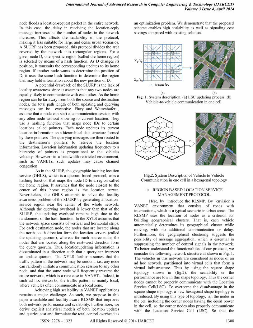
Fig. 1. System description. (a) LSC updating process. (b)
Vehicle-to-vehicle communication in one cell.
Fig.2. System Description of Vehicle to Vehicle
Communication in one cell in a hexagonal topology
III. REGION BASED LOCATION SERVICE
MANAGEMENT PROTOCOL
Here, by introduce the RLSMP. By envision a
VANET environment that consists of roads with
intersections, which is a typical scenario in urban areas. The
RLSMP uses the location of nodes as a criterion for building geographical clusters. That is, each vehicle
automatically determines its geographical cluster while
moving, with no additional communication or delay.
Furthermore, the geographical clustering suggests the
possibility of message aggregation, which is essential in
suppressing the number of control signals in the network.
To better understand the functionalities of our protocol, we
consider the following network structure as shown in Fig. 1.
The vehicles in this network are considered as nodes of an
ad hoc network, partitioned into virtual cells that form a
virtual infrastructure. Thus by using the square shape topology shown in (fig.2), the scalability or the
performance are low in this shape topology, Thus the corner
nodes cannot be properly communicate with the Location
Service Cell(LSC). To overcome the disadvantage in the
square shape topology, a new hexagonal shape topology is
introduced. By using this type of topology, all the nodes in
the cell including the corner nodes having the equal power
in the cell, so the corner nodes also properly communicate
with the Location Service Cell (LSC). So that the

International Journal of Advanced Research in Computer Engineering & Technology (IJARCET)
Volume 3 Issue 4, April 2014
ISSN: 2278 – 1323 All Rights Reserved © 2014 IJARCET 1309
performance of the Cell Leader and Location Service Cell
has been improved.
A key property of the RLSMP is that nodes are
grouped into geographical clusters. Consequently, the
location information is restricted in a geographical cluster
in the network. This explains the strategy of the protocol in denoting the central cell of each cluster as a home region or
a location-service-management entity. Thus, nodes that are
physically located in the central cell of one cluster are
responsible for storing current location information about
all nodes that belong to that cluster. This central cell is
called the location service cell (LSC). Thus, the location
information is locally kept inside one cluster. The CL
aggregates the location information about all the nodes in
its cell and forwards the aggregated control message to the
LSC of its cluster. Specifically, each CL stores detailed
information about the mobile nodes that it manages.
sections.
A. A. CL Updating in the RLSMP
As stated before, the CL tracks the mobility of
nodes within the cell and keeps the mobile node location
information uptodate. For each movement, a mobile node updates its location to the CL as follows.The decision of CL
updating is based on the mobile node’s location relative to
the center of the cell. By analyzing this information, the
mobile node can make a decision without consulting other
nodes, which minimizes the overhead.
In the fig 3 CL updating cost. Random-walk
mobility model. The RLSMP, on the other hand, reduces
the update cost since the CL is located in the center of the
cell. It is worth noting that the cost of CL updates in the
RLSMP is equivalent to the cost of intracell movement
when r is large as it is a dominant cost.
B. LSC Updating in the RLSMP
The LSC is defined as the central cell of a cluster whose
member nodes are responsible for keeping track of all the
mobile nodes that are located in the cluster. The RLSMP
relies on aggregating and forwarding the location updating
The LSC is defined as the central cell of a cluster whose
member nodes are responsible for keeping track of all the
mobile nodes that are located in the cluster. The RLSMP relies on aggregating and forwarding the location updating
messages. This process is achieved by all CLs residing in
the cluster and must be synchronized among them. Indeed,
a time schedule, which is denoted by Time_to_Send, is used in each CL to know when to begin sending the
aggregated message. Recall that in each cell, the CL is
responsible for
Fig. 3. CL updating cost by Random-walk mobility model.
forwarding the aggregated packets of all mobile nodes
residing in the cell. Each CL stores detailed information
about the mobile nodes that it manages. This information
contains the node ID, the X–Y coordinates of the node location, the time of the last update, and the velocity and
direction of the node movement. At the same time, the CL
forwards summarized information (node ID, cell ID, and
time stamp) about those nodes to the LSC of its cluster. The
forwarding zone is defined by the tree structure (shown in
Fig. 1), which visits the CLs. In this figure, the arrows
represent flows of message aggregation, and each square
represents a cell with one CL. When a CL receives location information messages from another CL in its sub-trees, it
collects and combines them into one aggregated message,
which is forwarded to its parent until it reaches the LSC of
the cluster. Such message aggregation process effectively
suppresses the number of itinerant messages in the whole
network. The LSC updating algorithm is described by the
pseudo code in Algorithm 1.
Algorithm 1 Location Information Updating Algorithm
1: In one Cluster do:
2: if (Cell Leader) then
3: Save detailed information (nodes_ID, X, Y, V, Dir) in
local_table;
4:Aggregate summarized information ( nodes_ID,Cell_ID,
Time Stamp);
5: if (packet_size ≥ packet_size_limit) then
6: Go to step 13;
7: else
8: Continue aggregation in the same packet; 9: if (Time_to_Send) then
10: Go to step 13;
11: end if
12: end if
13: Send the aggregated message to the next Cell Leader in
the downstream direction toward the LSC;
14: if (next Cell Leader is the LSC) then
15: Stop;

International Journal of Advanced Research in Computer Engineering & Technology (IJARCET)
Volume 3 Issue 4, April 2014
ISSN: 2278 – 1323 All Rights Reserved © 2014 IJARCET 1310
16: end if
17: end if
Using this strategy, nodes located in the center of the LSC
can act as a CL of that LSC. This ―special‖ CL has detailed
information of the mobile nodes of that LSC, as well as
summarized information of all nodes belonging to the corresponding cluster. Hence, LSC renewal depends on the
renewal of this ―special‖ CL. This latter operation follows
the same procedure stated above in Section III-A, i.e., using
the beaconing mechanism.
Fig. 4. LSC updating cost.
Fig. 4 depicts the LSC update cost (in terms of bytes) of all underlying protocols as a function of the
network area A under the 2-D random-walk model.
C. Location-Information Retrieval in the RLSMP
The RLSMP is the first protocol that uses message
aggregation in location querying.. When a vehicle wants to
communicate with another one, it forwards a query to the
CL, which aggregates the querying messages and forwards
them to the location servers, i.e., the nodes that are located in the local LSC. If the queries are answered by the local
LSC, i.e., the destinations are registered in the same cluster
as the source code is called as local query otherwise this
query is called as global query, where the destinations are
located in a cluster other than the local cluster of the source
nodes. In this case, the local LSC does not directly forward
global queries; instead, they are delayed for a pre-specified
time. This delay is essential for aggregating queries that are
sent by the vehicles residing in that cluster.
The forwarded aggregated queries pass through the
different LSCs, as shown in Fig. 5. They are forwarded in a
spiral shape around the local LSC, where this spiral shape visits all surrounding LSCs until it finds information about
the destinations’ location. The nodes inside the visited
LSCs will make use of the information stored in their own
tables to determine the destinations’ IDs. The use of the
spiral shape is motivated by the fact that any location
service protocol has to account for the locality awareness
property of VANETs.
Fig. 5. Spiral shape of the location-information retrieval.
IV. CONCLUSION
To improve the efficiency of VANETs network, the RLSMP used, which is a new location-service-
management protocol that supports minimum overhead and
locality awareness in VANETs. The RLSMP uses message
aggregation that is enhanced by geographical clustering to
reduce signaling overhead. It also resolves the localization
of a destination node by using local search, which begins by
exploring the vicinity of the source node. Thus, to avoid the
relatively long distance signaling incurred in other
protocols in both location updating and querying processes.
Using both analytical and simulation approaches, the
RLSMP is compared with existing solutions (the SLURP,
the HLS, and the XYLS). To achieve this, firstly ,develop the analytical models to evaluate both the location updates
and queries for a general 2-D random-walk model. In
addition, simulations have been conducted using real
mobility patterns to evaluate the performance of the
protocol in real mobility situations. Secondly, by
investigating the optimal configuration of the RLSMP that
minimizes the total signaling cost. Therefore the RLSMP
minimize communication overhead and improves the
locality awareness when increasing the cell size as well as
the network size. As such, the RLSMP stands out as a
promising candidate for large-scale wireless ad -hoc networks such as VANETs.
REFRENCES
[1] J. Zhao and G. Cao, ―VADD: Vehicle- assisted data
delivery in vehicular ad hoc networks,‖ IEEE Trans. Veh. Technol., vol. 57, no.
3,pp. 1910–1922, May 2008.
[2] S.Panichpapiboon andW. Pattara-atikom, ―Connectivity requirements for
self-organizing traffic information systems,‖ IEEE Trans. Veh. Technol., vol.
57, no. 6, pp. 3333–3340, Nov. 2008.
[3] J. Zhao, Y. Zhang, and G. Cao, ―Data pouring and buffering on the road:A
new data dissemination paradigm for vehicular ad hoc networks,‖ IEEE Trans.
Veh. Technol., vol. 56, no. 6, pp. 3266–3277, Nov. 2007.
[4] B. Ducourthial, Y. Khaled, and M. Shawky, ―Conditional
transmissions:Performance study of a new communication strategy in
VANET,‖ IEEE Trans. Veh. Technol., vol. 56, no. 6, pp. 3348–3357, Nov.
2007.
[5] K.-H. Chiang and N. Shenoy, ―A 2-D random-walk mobility model for
location-management studies in wireless networks,‖ IEEE Trans. Veh.
Technol., vol. 53, no. 2, pp. 413–424, Mar. 2004.
[6] M. Ksemann, H. Fler, H. Hartenstein, and M. Mauve, ―A reactive location
service for mobile ad hoc networks,‖ Dept. Sci., Univ Mannheim, Mannheim,
Germany, Tech. Rep. TR-02-014, Nov. 2002s