Embed Size (px)
Citation preview
STATUS AND CONSERVATION OF THE
PALOUSE GRASSLAND IN IDAHO
by
Juanita Lichthardtand
Robert K. MoseleyConservation Data Center
January 1997
Idaho Department of Fish and Game600 South Walnut, P.O. Box 25
Boise, Idaho 83707
U.S. Fish and Wildlife Service
Purchase Order No.: 14420-5-0395
i
ABSTRACT
The Palouse Grassland is recognized as an ecologically distinct element of the Pacific NorthwestBunchgrass biome. The area once occupied by Palouse Grassland has seen nearly 100%conversion to cultivated agriculture, making it an imperiled ecosystem. Remnants of PalouseGrassland vegetation are now restricted to small areas on the edge of cultivated fields, or rockyslopes along the margin of the former prairie. The easternmost extent of the prairie region extendsinto Idaho, where three climax grassland associations have been described: Festuca idahoensis-Symphoricarpos albus (Idaho fescue–common snowberry), Festuca idahoensis–Rosa nutkana(Idaho fescue-Nootka rose), and Festuca scabrella–F. idahoensis (rough fescue–Idaho fescue).These communities in turn, are habitat for six, globally rare plant species endemic to the region.This report documents the results of a 1996 survey of Palouse Grassland remnants in Idaho.Grassland communities were sampled, rare plant populations were documented, and grasslandremnants were evaluated for their conservation value. Canopy cover data from plot sampling aresummarized in a releve table. Stand composition is then evaluated in the context of plantassociations recognized in the Western Regional Vegetation Classification (WRVC) for the studyarea. Our data do not support the existence of two distinct vegetation zones in Idaho portions ofthe prairie. Fourteen grassland sites with conservation value were identified and documented,noting their location, size, condition, biodiversity values, ownership and threats. This informationwas entered into site basic records (SBR), in the Conservation Data Center's Biological andConservation Database, and the records appended to this report.
ii
TABLE OF CONTENTS
Page
ABSTRACT........................................................................................................................i
TABLE OF CONTENTS .................................................................................................ii
LIST OF TABLES......................................................................................................... iii
LIST OF APPENDICES .................................................................................................iv
INTRODUCTION..............................................................................................................1
STUDY AREAClimate.........................................................................................................................4Geology........................................................................................................................4Palouse .........................................................................................................................5Camas Prairie ...............................................................................................................5Rathdrum Prairie ..........................................................................................................5
VEGETATION OF THE PALOUSE GRASSLANDGrassland associations ..................................................................................................7Conservation ranks .......................................................................................................7Festuca idahoensis–Symphoricarpos albus(Idaho fescue–common snowberry) association ............................................................8Festuca idahoensis–Rosa nutkana(Idaho fescue–Nootka rose) association ........................................................................9Festuca scabrella–Festuca idahoensis(rough fescue–Idaho fescue) association .....................................................................10Threats .......................................................................................................................10Protection ...................................................................................................................11
CHARACTERIZATION OF PALOUSE GRASSLAND COMMUNITIESSampling sites ............................................................................................................12Methods......................................................................................................................12Results........................................................................................................................13Classification of stands ...............................................................................................16Daubenmire's Stand 162 .............................................................................................16
RARE FLORA OF THE PALOUSE GRASSLAND...................................................19Threats .......................................................................................................................20Protection ...................................................................................................................21
CONSERVATION SITES ...............................................................................................22
REFERENCES.................................................................................................................25
iii
LIST OF TABLES
Page
Table 1. Areas of Idaho containing Palouse Grasslands and their correspondingsubdivisions of floristic and ecoregional classifications...........................................2
Table 2. Selected climatic variables for two climate stations on the margin of thePalouse Grassland ...................................................................................................4
Table 3. Ordered table of grassland stands sampled. Stands with similar compositionhave been grouped and species ordered to show recurring groups (boxed).Only selected species appear in the table. Values are cover estimates withintwelve cover classes. † marks exotic species ........................................................14
Table 4. Comparison of community composition of Daubenmire's stand 162 sampledin 1954, and again in 1996. Values for 1954 are means of 40 microplots, tothe nearest 1%. For 1996, percent cover is given as a range. "P" indicates thatthe species was observed in the stand but did not occur in the plot.. ......................18
Table 5. Plant taxa that are endemic, or nearly endemic, to the Palouse Grassland, andtheir conservation ranks (Conservation Data Center 1994; Washington NaturalHeritage Program 1994)........................................................................................19
Table 6. Proposed grassland conservation sites documented during a 1996 survey ofremnant Palouse vegetation. Further information is stored in site basic records(SBR) in the CDC's Biological and Conservation Data System (BCD;Appendix 6). See text for explanation of ranks......................................................23
Table 7. Proposed woodland, rare plant conservation sites documented during a 1996survey of remnant Palouse vegetation. Further information is stored in sitebasic records (SBR) in the CDC's Biological and Conservation Data System(BCD; Appendix 6). See text for explanation of ranks.. ........................................24
iv
LIST OF APPENDICES
Appendix 1 Maps
Map 1 Palouse Grassland and Canyon Grassland divisions of the PacificNorthwest Bunchgrass biome in Idaho, in relation to geographicareas known as the Rathdrum Prairie (1), Palouse (2) and CamasPrairie (3).
Map 2 General locations of grassland stands sampled
Map 3 General locations of proposed conservation sites
Appendix 2 Community and site survey forms
Appendix 3 Releve table of grassland stands sampled
Appendix 4 Line drawings of rare Palouse Grassland plants
Appendix 5 Site survey form
Appendix 6 Site basic records (SBR) for proposed Palouse Grassland andwoodland rare-plant conservation sites
1
INTRODUCTION
Grasslands of the Pacific Northwest constitute one of the major vegetation types or biomes inNorth America (Sims 1988). These grasslands are often called Palouse Prairie, even thoughthey extend far beyond the Palouse region of eastern Washington and adjacent Idaho(Caldwell 1961). To remedy this confusion between an ecological and a geographic name,Tisdale (1983) recommended changing the name of the grasslands to Pacific NorthwestBunchgrass, which indicates both the area occupied and the life form of the dominantspecies. Unfortunately, this nomenclatural innovation has not been widely accepted yet. Astudy of Pacific Northwest Bunchgrass grasslands in Idaho, Oregon, and Washingtonsubdivided the biome into several ecological divisions and subdivisions based on thecomposition and structure of the vegetation, and on physical features (Idaho Natural HeritageProgram et al. 1986; The Nature Conservancy et al. 1987). Two of these divisions occur inIdaho: Canyon Grasslands and Palouse Grasslands (Tisdale 1986a).
Canyon Grasslands occur in the deep canyon systems that dissect the Columbia Plateau.They are characterized by steep slopes, high relief, and grassland vegetation punctuated byisolated stands of shrubs and trees. Although many of the same bunchgrasses that dominateCanyon Grasslands also dominate Palouse Grasslands, vegetation studies have describeddifferent plant associations in the two areas (Daubenmire 1970; Tisdale 1986b; Johnson andSimon 1987). The best examples of these grasslands occur in the Snake, Salmon, GrandeRonde, and Imnaha river canyons of west-central Idaho and adjacent Oregon andWashington. To a large extent these grasslands are intact, never having been extensivelyconverted to other uses (Tisdale 1986a). The major exceptions are the development of theurban center of Lewiston, Idaho, and Clarkston, Washington, and the widespread invasion ofnoxious weeds resulting from heavy livestock grazing (Tisdale 1983; Mancuso and Moseley1994). See Tisdale (1986b), Johnson and Simon (1987), and Mancuso and Moseley (1994)for more extensive ecological descriptions of Canyon Grasslands.
In contrast to the Canyon Grasslands, we define the Palouse Grasslands as the native steppevegetation occurring on the gently rolling basalt plateaus and adjacent mountain foothills thatare covered with wind-deposited loess (Idaho Natural Heritage Program et al. 1986).Palouse Grasslands are the focus of this report.
The word “Palouse”, which is affixed to the region, the river whose basin encompasses mostof the area, and the original inhabitants, has been attributed to both French and Indian originsmeaning a “sea of grass” or “grassland plains” (Caldwell 1961). In ecological usage, theterm Palouse has had a much broader meaning. It has been used for grasslands as far southas Utah (Stoddard 1941), east to Montana, and north into British Columbia (Weaver andClements 1938; Humphrey 1945; Caldwell 1961; Tisdale 1983; Sims 1988). Daubenmire, inhis extensive ecological investigations of the region, refrained from using Palouse to describethe Pacific Northwest Bunchgrass grasslands. He instead chose to name vegetation zonesafter the dominant species, such as wheatgrass-bluegrass zone and fescue-wheatgrass zone(e.g., Daubenmire 1942; 1946; 1952; 1956; 1970; Franklin and Dyrness 1988; Tisdale 1994).
2
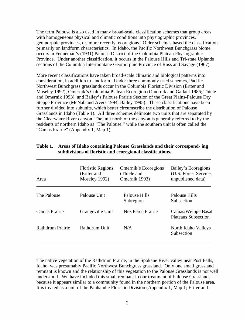
The term Palouse is also used in many broad-scale classification schemes that group areaswith homogeneous physical and climatic conditions into physiographic provinces,geomorphic provinces, or, more recently, ecoregions. Older schemes based the classificationprimarily on landform characteristics. In Idaho, the Pacific Northwest Bunchgrass biomeoccurs in Fenneman’s (1931) Palouse District of the Columbia Plateau PhysiographicProvince. Under another classification, it occurs in the Palouse Hills and Tri-state Uplandssections of the Columbia Intermontane Geomorphic Province of Ross and Savage (1967).
More recent classifications have taken broad-scale climatic and biological patterns intoconsideration, in addition to landform. Under three commonly used schemes, PacificNorthwest Bunchgrass grasslands occur in the Columbia Floristic Division (Ertter andMoseley 1992), Omernik’s Columbia Plateau Ecoregion (Omernik and Gallant 1986; Thieleand Omernik 1993), and Bailey’s Palouse Prairie Section of the Great Plains-Palouse DrySteppe Province (McNab and Avers 1994; Bailey 1995). These classifications have beenfurther divided into subunits, which better circumscribe the distribution of PalouseGrasslands in Idaho (Table 1). All three schemes delineate two units that are separated bythe Clearwater River canyon. The unit north of the canyon is generally referred to by theresidents of northern Idaho as “The Palouse,” while the southern unit is often called the“Camas Prairie” (Appendix 1, Map 1).
Table 1. Areas of Idaho containing Palouse Grasslands and their correspond- ingsubdivisions of floristic and ecoregional classifications.
Floristic Regions Omernik’s Ecoregions Bailey’s Ecoregions(Ertter and (Thiele and (U.S. Forest Service,
Area Moseley 1992) Omernik 1993) unpublished data)
The Palouse Palouse Unit Palouse Hills Palouse HillsSubregion Subsection
Camas Prairie Grangeville Unit Nez Perce Prairie Camas/Weippe BasaltPlateaus Subsection
Rathdrum Prairie Rathdrum Unit N/A North Idaho ValleysSubsection
The native vegetation of the Rathdrum Prairie, in the Spokane River valley near Post Falls,Idaho, was presumably Pacific Northwest Bunchgrass grassland. Only one small grasslandremnant is known and the relationship of this vegetation to the Palouse Grasslands is not wellunderstood. We have included this small remnant in our treatment of Palouse Grasslandsbecause it appears similar to a community found in the northern portion of the Palouse area.It is treated as a unit of the Panhandle Floristic Division (Appendix 1, Map 1; Ertter and
3
Moseley 1992) and as a subsection of the Bailey’s Okanogan Highlands Section of theNorthern Rocky Mountain Province (McNab and Avers 1994; Bailey 1995; Table 1). Thisreport deals primarily with the Palouse and Camas Prairie regions.
Beginning early in this century, no ecological discussion of the Palouse Grasslands omittedmentioning that a majority of this biome has been converted to agriculture, and most of whatremained had been altered by livestock overgrazing (e.g., Weaver 1914; Weaver andClements 1938; Daubenmire 1940; 1942; 1970; Young 1943; Humphrey 1945; Buechner1953; Tisdale 1961; 1986a). In fact, a recent vegetation map of Idaho failed to recognize aPalouse Grasslands cover type because of its near total conversion to agricultural and urbanuses (Caicco 1989; Caicco et al. 1995). In contrast, the Canyon Grasslands are recognized asa mapping unit that covers 469,410 acres in the state (Caicco et al. 1995). During the initialsettlement of the Palouse area in the 1860's, the land was primarily used for grazing. It wasquickly recognized, however, that the deep loessal soils characteristic of the region wereexcellent for growing wheat. Starting about 1880, this new type of land use began to convertthe grasslands to row crops, and by about 1910 all areas that could be plowed were broughtinto cropland (Daubenmire 1940; Buechner 1953; Tisdale 1961). Livestock grazingcontinued on the larger stands of remaining Palouse Grassland that were too rocky orotherwise impractical to plow. These were eventually converted to non-native vegetationtypes (Daubenmire 1940; Young 1943). There were, however, small remnants that remainedin a relatively unaltered state, mostly as corners of fields or rocky areas that were notincorporated into livestock operations (Weaver 1914; Daubenmire 1940; 1970; Young 1943;Aller et al. 1981; Tisdale 1986a; Thiele and Omernik 1993).
As a consequence of this human alteration, the Palouse Grasslands are considered one of themost endangered ecosystems in the United States. It is estimated that only 0.1% of thesegrasslands remain in a natural state (Noss 1995; Noss et al. 1995). Several of the PalouseGrassland plant associations described by Daubenmire (1970) are considered globallyimperiled by The Nature Conservancy and Natural Heritage/Conservation Data Centernetwork (Grossman et al. 1994).
4
STUDY AREA
As mentioned in the Introduction, there are two disjunct areas in Idaho that had PalouseGrasslands as their native vegetation. The area north of the Clearwater River canyon is theeasternmost extension of the Palouse, the area to the south, called the Camas Prairie, islocated entirely within Idaho (Appendix 1, Map 1). Because only a small portion of thePalouse extends into Idaho, the Camas Prairie formed the bulk of the study area. Climaticand geological processes that shaped the two areas were similar, resulting in the samevegetational Formation. However, important distinctions exist. Each area is describedindividually below following general discussions of climate and geology.
Climate
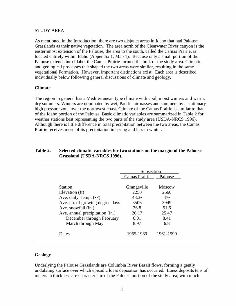
The region in general has a Mediterranean type climate with cool, moist winters and warm,dry summers. Winters are dominated by wet, Pacific airmasses and summers by a stationaryhigh pressure zone over the northwest coast. Climate of the Camas Prairie is similar to thatof the Idaho portion of the Palouse. Basic climatic variables are summarized in Table 2 forweather stations best representing the two parts of the study area (USDA-NRCS 1996).Although there is little difference in total precipitation between the two areas, the CamasPrairie receives more of its precipitation in spring and less in winter.
Table 2. Selected climatic variables for two stations on the margin of the PalouseGrassland (USDA-NRCS 1996).
Subsection Camas Prairie Palouse
Station Grangeville MoscowElevation (ft) 2250 2660Ave. daily Temp. (•F) 48.3• 47•Ave. no. of growing degree days 3506 3949Ave. snowfall (in.) 36.8 51.6Ave. annual precipitation (in.) 26.17 25.47
December through February 6.01 8.41March through May 8.97 6.8
Dates 1965-1989 1961-1990
Geology
Underlying the Palouse Grasslands are Columbia River Basalt flows, forming a gentlyundulating surface over which episodic loess deposition has occurred. Loess deposits tens ofmeters in thickness are characteristic of the Palouse portion of the study area, with much
5
shallower deposits on the Camas Prairie. Soils have formed in loess or in a mixture of basaltbedrock and loess. Because of the mesic climate, soils of the Palouse Grassland areMollisols rather than Aridisols, with higher organic matter and clay contents than otherloessal soils of the Columbia Plateau (Thiele and Omernik 1993). Characteristic soils are inthe Xeroll subgroup, reflecting the high organic matter accumulation and a climatic regimein which most of the precipitation occurs outside the growing season.
The Palouse
The Palouse as a whole, is an elliptical area ranging from Spokane in the north to the SnakeRiver and Clearwater River canyons in the south. The eastern boundary is determined by thetransition in Idaho to the Rocky Mountains, with its resultant increased precipitation, higherelevations, and forest vegetation. Thiele and Omernik (1993) delineated the westernboundary in Washington along the transition from mesic Palouse soils to the dryer WallaWalla soil, as interpreted from county soil surveys. Rainfall ranges from 16-23 inches/year,with the Idaho portion receiving the most. The Palouse in Idaho has an average elevation ofabout 2,500 feet.
The Palouse hills resulted from strong winds picking up mostly silt size particles from south-central Washington and carrying them eastward into Idaho. Palouse soils in Idaho occur inan area that received the most loess, with depths of at least 100 feet being common (Barkeret al. 1983). It has been suggested that the shape of the Palouse hills resulted from strongwind action from the southwest, which formed sharp, dune-like crests toward the northeast.On the north and east sides of these dunes, nivation cirques and amphitheaters formed,caused by the accumulation of snowdrifts and subsequent erosion (Thiele and Omernik1993). Poorly defined drainage patterns are characteristic of the dune-like topography.
In a recent delineation of the subsections of Bailey’s (1995) ecoregions by the ForestService, the Palouse subsection is 1,586,050 acres. Thirty-six percent (571,000 acres) is inIdaho, the remainder in Washington. Not all of this area was Palouse Grasslands; manyforested steptoes, foothills and ridges of the adjacent mountains are included in this figure.
Camas Prairie
The Camas Prairie, sometimes called the Nez Perce Prairie, is a rolling plain bounded by thecanyons of the Clearwater River and its South Fork on the north and east, and the SalmonRiver canyon and mountain uplifts on the south and west. Though somewhat similar to thePalouse, it differs primarily in having higher elevations and shallower soils. Because theCamas Prairie was out of the main path of loess deposition, the soils are shallower and lackthe dune-like appearance of the Palouse hills (Barker et al. 1983; Thiele and Omernik 1993).The loess mantle is generally less than 1 meter. Because of the shallower loess and higherspring precipitation on the Camas Prairie, weathering of the loess into clays has beenaccelerated, resulting in soils with a higher clay content than on the Palouse (Barker 1982).The average elevation of the Camas Prairie is about 3,500 feet.
In a recent delineation of the subsections of Bailey’s ecoregions by the Forest Service, theCamas Prairie subsection is 573,513 acres, all in Idaho. Similar to the Palouse, this acreageis not all Palouse Grassland; many areas that were previously forested are also included.
6
Rathdrum Prairie
Because it was called a “prairie,” the Rathdrum Prairie was presumably a grassland duringpre-settlement times, although its native vegetation is little studied and not well understood.Boone (1988) defines the Rathdrum Prairie as “an agricultural area 5-15 miles wide thatextends northeast from Spokane for 50 miles" (Appendix 1, Map 1). Nearly all of the prairiehas been converted to agriculture, residential, or urban uses and its original extent in Idaho isunknown. We found one small remnant of an herb-rich grassland in 1990 (Taylor et al.1990), from which all ecological information on native vegetation of the Rathdrum Prairie isderived. No other studies of Rathdrum Prairie grassland vegetation are known. Based onthis discovery, Ertter and Moseley (1992) delineated the Rathdrum Unit of the otherwisedensely forested Panhandle Floristic Division.
The Rathdrum Prairie is a glacial outwash plain, lying at 2,200 feet elevation, that has low,undulating relief. The valley that encompasses the Rathdrum Prairie carried outwash fromthe continental icesheet to the north and the floodwaters of Pleistocene Lake Missoula.Because of the this, the soils are very deep and well-drained, formed in glacial outwashmixed with loess and volcanic ash (Weisel 1981). Virtually no free water occurs on theprairie surface, although a large aquifer flows beneath it (Ertter and Moseley 1992). Theaverage annual precipitation is 24 inches (Weisel 1981).
7
VEGETATION OF THE PALOUSE GRASSLAND
Native vegetation of the Palouse Grassland was that of a bunchgrass steppe with shrubthickets in draws and on north hillslopes, usually dominated by Crataegus douglasii (blackhawthorn). Herbaceous cover was dense with a high cover of perennial forbs. Spreadingshrubs such as Symphoricarpos albus (snowberry) and Rosa spp. (wild rose) formedinclusions of shrub thickets within the grassland. At the margins of the grassland reliefincreases and north slopes support coniferous forest.
Grassland associations
In the most intensive study of Palouse Grassland vegetation to date, Daubenmire (1970)identified three climax vegetation zones: Agropyron spicatum–Festuca idahoensis(bluebunch wheatgrass–Idaho fescue), Festuca idahoensis-Symphoricarpos albus (Idahofescue–common snowberry) and Festuca idahoensis–Rosa nutkana (Idaho fescue-Nootkarose). Only the latter two occur in Idaho portions of the prairie. Daubenmire called these the"zonal series" and identified a number of phases and inclusions in each. He mapped theseassociations based on regional climatic patterns, soils, and vegetation sampling, conductedprimarily in Whitman county, Washington. Only two stands were actually sampled in Idaho.
Daubenmire described three stands on the margin of the grassland in which Festucascabrella was dominant or codominant, but did not differentiate these from the F. idahoensisseries. In his overview of the Pacific Northwest Grasslands, Tisdale (1983) recognized aseparate Festuca scabrella–F. idahoensis association based on the work of Mueggler andStewart (1980) in western Montana. This association only occurs in a few isolated sites inIdaho.
Conservation ranks
Recognized plant associations are given conservation rankings by the Natural Heritage/Conservation Data Center network based on the number of documented occurrences of thecommunity and the extent to which they are threatened. Global ranks range from G5(common) to G1 (most imperiled) and State ranks the same. Heritage Programs in Oregon,Washington, Montana, and Idaho contribute to the current ranks. Because examples of thesegrassland associations currently exist only as small remnants that are highly susceptible todegradation, they are considered globally rare and occurrences are tracked in the same wayas rare plants and animals. Festuca-Symphoricarpos is currently ranked G2 (globallyimperiled because of rarity or because other factors demonstrably make it very vulnerable toextinction) and Festuca -Rosa is ranked G3 (globally rare or uncommon but not imperiled).However, a rank of G1 (critically imperiled) has appropriately been proposed for bothassociations based on the scarcity of their occurrence, historical reduction, and a number ofserious threats (Steven Rust pers. comm.). Six rare plant species associated with thesecommunities are also tracked by the Idaho CDC. While Festuca scabrella–F. idahoensis israre in Idaho, it also occurs in Montana and British Columbia, as reflected in a global rank ofG4G5.
8
Festuca idahoensis-Symphoricarpos albus(Idaho fescue-common snowberry) association
The following information was taken from the Community Characterization Abstract (CCA)stored in the CDC's Biological and Conservation Data System.
Global range: The historical range of Festuca–Symphoricarpos was Whitman and partof Spokane counties, Washington, and the adjoining area of Idaho south of Lake Coeurd'Alene.Idaho range: In Idaho, Festuca–Symphoricarpos was confined to prairie areas betweenthe Clearwater River to the south and Lake Coeur d'Alene to the north.Environment: The Festuca idahoensis-Symphoricarpos albus association occurs in thecooler, moister portion of the Palouse Grassland, from 2000 to 4000 feet elevation. Soilsevidently dry out to a depth of 50 cm, which is too deep for conifer seedling survival.However, it is enough moisture to support a variety of mesic forb species.Most abundant species: Festuca idahoensis, Agropyron spicatum, Koeleria cristata,Achillea millefolium, Balsamorhiza sagittata, Geum triflorum var. ciliatum, Hieraciumalbertinum, Lupinus sericeus, Potentilla gracilis, Symphoricarpos albus, Rosa woodsii,and Rosa nutkana.Most constant species: Festuca idahoensis, Agropyron spicatum, Symphoricarposalbus, Achillea millefolium, Balsamorhiza sagittata, and Geum triflorum var. ciliatum.Vegetation: This is a lush meadow-steppe association, dominated by the perennialbunchgrasses Festuca idahoensis and Agropyron spicatum, with Koeleria cristata alsoabundant. In this vegetation type, A. spicatum is an ecotype that is rhizomatous ratherthan caespitose. This association has a very rich forb component, with many speciescommon to abundant. The deciduous shrub Symphoricarpos albus is always present,with up to 20% cover, but is dwarfed (less than 18 inches tall) and does not contribute tothe physiognomic structure of this type. Rosa woodsii and R. nutkana also have a dwarfstature, when present. Species richness is very high. The cryptogam layer is very well-developed on undisturbed sites.
Citation: Daubenmire (1970)
Conservation ranks:
Global: The Festuca –Symphoricarpos association is ranked G2 (globally imperiledbecause of rarity or because other factors demonstrably make it very vulnerable toextinction)Idaho: S1 (critically imperiled because of extreme rarity or because some factor ofits biology makes it especially vulnerable to extinction )Washington: S1Reason for rank: Most of the area originally supporting this vegetation type hasbeen converted to cultivated agriculture.Recommendations: The fact that this association has a state rank of S1 in both Statesof occurrence suggests that a global rank of G1 may be appropriate.
9
Festuca idahoensis-Rosa nutkana(Idaho fescue-Nootka rose) association
The following information was taken from the Community Characterization Abstract (CCA)stored in the CDC's Biological and Conservation Data System.
Global range: Daubenmire (1970) considered Festuca idahoensis-Rosa to be restrictedto areas east of the Blue Mountains in eastern Oregon, southeastern Washington, andIdaho.
Idaho range: In Idaho, Festuca–Rosa is confined to the Camas Prairie region east of theSnake River and south of the Clearwater River.
Environment: Occurs from 2000 to 4000 feet elevation on the east flanks, and in therainshadow, of the Blue Mountains. The climate of this region is colder than in theFestuca-Symphoricarpos zone to the north, drier in winter, and wetter in spring. Soilsevidently dry out to a depth of 50 cm, which is too deep for conifer seedling survival.However, it is enough moisture to support a diversity of perennial forbs.
Most abundant species: Festuca idahoensis, Agropyron spicatum, Koeleria cristata,Poa secunda var. secunda, Balsamorhiza sagittata, Besseya rubra, Geum triflorum, andPotentilla gracilis.
Most constant species: Festuca idahoensis, Agropyron spicatum, Koeleria cristata,Balsamorhiza sagittata, Besseya rubra, Calochortus elegans, Geum triflorum, andCollinsia parviflora.
Vegetation: This is a lush meadow-steppe association, dominated by the perennialbunchgrasses Festuca idahoensis and Agropyron spicatum (together averaging from 60%to over 100% cover), with Koeleria cristata also abundant. It has a very rich forbcomponent (often with 100% cover), with many species common to abundant. Thedeciduous shrubs, Rosa nutkana and/or Rosa woodsii have generally less than 10%cover, are shorter than the dominating bunchgrasses and do not contribute to thephysiognomic structure of this type. Species richness is very high. The cryptogam layeris very well-developed on undisturbed sites, also with high species richness. Thisassociation has no Symphoricarpos albus occurring within it, nor are there thickets of thisspecies within the grassland mosaic.
Citation: Daubenmire (1970)
Conservation ranks:
Global: The Festuca idahoensis-Rosa association is ranked G3 (globally rare oruncommon but not imperiled).Idaho: S2 (imperiled because of rarity or because other factors demonstrably makeit very vulnerable to extinction)Washington: S1
10
Reasons for rank: This association is confined to a very limited area on the marginof the Palouse Grassland, east of the Blue Mountains. Nearly all of this area has beenconverted to cultivated agriculture. On rangeland this type has largely becomedominated by Poa pratensis (Kentucky bluegrass) due to grazing pressures.Recommendations: A rank of S1 for Idaho is warranted and likewise a global rankof G1.
Festuca scabrella-Festuca idahoensis(rough fescue-Idaho fescue) association
On the eastern margin of the Palouse Grassland, a F. scabrella–F. idahoensis associationoccurs at several scattered locations near the prairie–forest ecotone. Although widespread inwestern Montana, this association is very rare in Idaho. Mueggler and Stewart (1980)describe a F. scabrella–F. idahoensis association that is dominated by a mixture of Festucascabrella and F. idahoensis. Tisdale (1947) recognized a similar association in southernBritish Columbia, considering it a phase of Agropyron spicatum–Festuca scabrella. Furtherwest into Washington, F. scabrella occurs as an understory union with Pinus ponderosa(Ponderosa pine). The following information is from Mueggler and Stewart (1980):
Global range: Footslopes of the northern Rocky Mountains on both sides of thecontinental divide, north of 46° latitude, ranging into southwestern Alberta.
Idaho range: Rare, disjunct occurrences of this type in northern Idaho are found at theforest–prairie transition zone, along the eastern margin of the Palouse Grassland and onthe Rathdrum Prairie. It's southern extent is ca. 30 miles north of Moscow.
Environment: A community of the forest/grassland ecotone, F. scabrella–F. idahoensisoccurs on mountain slopes between 3000 to 7000 ft elevation, primarily within the 20- to30-inch precipitation zone.
Vegetation: This habitat type is dominated by a mixture of Festuca scabrella and F.idahoensis. Agropyron spicatum and shrubs are less conspicuous than in the F.scabrella–Agropyron spicatum type and may be absent. Koelaria cristata is highlyconstant. A Geranium viscosissimum (sticky geranium) phase is characterized by thepresence and often abundance of G. viscosissimum and Potentilla gracilis (cinquefoil).
Conservation ranks:
Global: G4G5 (this combination of ranks suggests that, although the association isnot considered globally rare, there may be some cause for long-term concern)Idaho: S1Montana: S4Washington: S1Reason for rank: This association is known from only four sites in Idaho andWashington. It is widespread in Montana but may be threatened there by invasion ofexotic forbs.
11
Threats
Ground cover disturbance in bunchgrass communities of the Palouse Grassland hashistorically led to increases in exotic grasses, mostly annual bromegrasses (Bromus spp.),and/or Kentucky bluegrass (Poa pratensis). Winter-annual grasses displaced the nativevegetation over extensive areas. These areas are now becoming dominated by the Eurasianwinter-annual, yellow star-thistle (Centaurea solstitialis). Although possibly slower to get afoothold in healthy, native bunchgrasses, this weed appears able to invade and out-competenative species. The weed has spread from the lower canyon elevations, up side canyons toupland areas. Wildlife, stock animals, and off-road vehicles are the most likely vectors forintroducing this and other aggressive exotics into native vegetation. Soil disturbance of areasas small as a few square feet will almost immediately be colonized.
Along the margins of the grassland region are found some of the largest and least alteredremnants, where slopes have prohibited cultivation and the historical use has been forlivestock grazing. These sites are threatened by potential increased grazing and by vehicletraffic, both of which hasten weed invasion. Also, some areas have seen a great surge inhomesite development in the foothills and shoulder slopes overlooking the prairie. Homesitedevelopment often represents a complete conversion of native vegetation to some other landuse. So, whereas cultivated agriculture reached its limits decades ago, the conversion ofnative prairie continues.
Protection
In Washington, Festuca-Symphoricarpos is protected at three, very small sites that have eachsuffered some degree of degradation by weeds. In addition, two occurrences of Festuca–Symphoricarpos and one of Festuca–Rosa are protected by Washington's registry programwhich relies on landowner cooperation. All of the sites are small (John Gamon, personalcommunication).
In Idaho, a small area of Palouse Grassland including Festuca–Symphoricarpos and Festucascabrella–F. idahoensis occurs in McCroskey State Park north of Moscow, a portion ofwhich has been proposed for National Natural Landmark designation. During our 1996survey 13 other grassland sites were identified with significant conservation value.
12
CHARACTERIZATION OF PALOUSE GRASSLAND COMMUNITIES
Twenty-two stands of Palouse Grassland vegetation in Idaho were sampled between July andSeptember, 1996. Our objective was to locate grassland remnants in as near as possible topristine condition, to quantitatively describe the bunchgrass communities present, and toevaluate their conservation value. Daubenmire (1970) is the sole source for descriptions ofPalouse communities, and he only sampled two stands in Idaho, so we wished to supplementhis characterizations with numerous additional plots.
Sampling sites
To locate sampling sites, we began with known, or previously documented grasslandremnants. We also visited known populations of rare plants associated with the PalouseGrassland, specifically, Haplopappus liatriformis (Palouse goldenweed), Silene spaldingii(Spalding's catchfly), and Aster jessicae (Jessica's aster). We targeted the best sites identifiedduring previous plant surveys (Lorain 1991; Gamon and Lorain 1991).
General locations of the stands sampled are shown in Appendix 1 (Map 2). Sample sitesranged from the town of Cottonwood at the south end, to 30 miles north of Moscow, with anorthern outlier on the Rathdrum Prairie near Post Falls. Within this region, prairieremnants can be found in field corners, on rocky microsites within cultivated rolling upland,on south and west-facing slopes of steptoes, on foothills of adjoining mountains, and at thehead of drainages between cultivated fields and the drainage bottom. These canyon headsmay be the sites most representative of the original grassland because they sometimesinclude areas of gentle slopes with a loess mantle. However, the sites most suitable forconservation are probably those of mountain slopes on the margin of the prairie because oftheir condition, size, and connectivity to other natural communities. Most prairie remnantsare very small, and the larger ones generally include some weedy and degraded portions. Forplace names associated with the sampled stands, see the footnotes of Appendix 3.
Methods
Relatively uniform bunchgrass stands in good condition were subjectively chosen, followingDaubenmire (1970), and plots arbitrarily placed within them, avoiding microsites andtransition zones to different vegetation types. We evaluated the condition of the vegetationbased on the cover of native perennial grasses relative to that of exotic grasses and forbs. Theuniform physiognomy of bunchgrass communities presented little opportunity for bias in plotplacement. Indicator shrubs were subordinate to the grasses, and, at the season of the yearwhen sampling was done, only the largest perennial forbs, such as Balsamorhiza and Lupinuswere prominent. Where different grass-dominated communities were evident, they weresampled separately.
One, 10 x 10 m plot was used to describe each community. Community and site surveyforms (Bourgeron et al. 1991; Appendix 2) were used to record species cover, height by lifeform, and a number of location and physical site variables. Canopy cover was estimated, byspecies, using 12 cover classes which are specified in the footnotes of Table 3. Species not
13
present in the plot, but occurring in its vicinity were also noted. A photo was taken of eachplot, and slide transparencies are on file at the CDC office in Boise.
Cover data were first summarized in a raw stand table with stands listed chronologicallyacross the top (Appendix 3). Down the left side of the table, species were listed as they wereencountered in plots, within five life form groups. All species recorded in plots are includedin Appendix 3.
The raw stand table was then examined for similarities among stands and for indicatorspecies, i.e., species of limited occurrence that are part of reoccurring species groups. A newtable was then created by eliminating species that were only encountered once, as well asinfrequent, exotic species. Stands were then reordered by grouping those of similarcomposition (Table 3). Species of limited occurrence were given more weight in groupingstands, as were known indicator species such as Symphoricarpos albus and Rosa spp. In thereordered table species were not placed into life form groups.
Since the clearest distinction among stands was presence or absence of Festuca scabrella, thefive F. scabrella stands were kept in the first five columns, although reordered slightly toreflect the similarity between stands 1 and 5. Species were then ordered by placing thoserestricted to Festuca scabrella stands at the top of the table. The degree of fidelity to thesestands diminishes as you go down the table until, near the middle, are species with highoverall frequency, and hence little value in grouping stands. Following these, are speciesthat were negatively correlated with Festuca scabrella. Ordering species in this way allowsyou to look for and accentuate recurring species combinations such as those boxed in Table3.
Results
The twenty-two stands sampled ranged in elevation from 2920 to 4440 feet. Slopes variedfrom 0 to 50%. Southerly aspects (130° to 230°) are notably missing, represented only bystand 2. It is difficult to find good-condition grassland on warm aspects because they are themost readily invaded by exotics.
Soils are all cold Mollisols (suborder Xeroll) formed in loess and residual bedrock. Amongstands, soils differed primarily in geologic parent material (basalt, metasediments, orgranite), rockiness, and the amount of loess mixed with residuum.
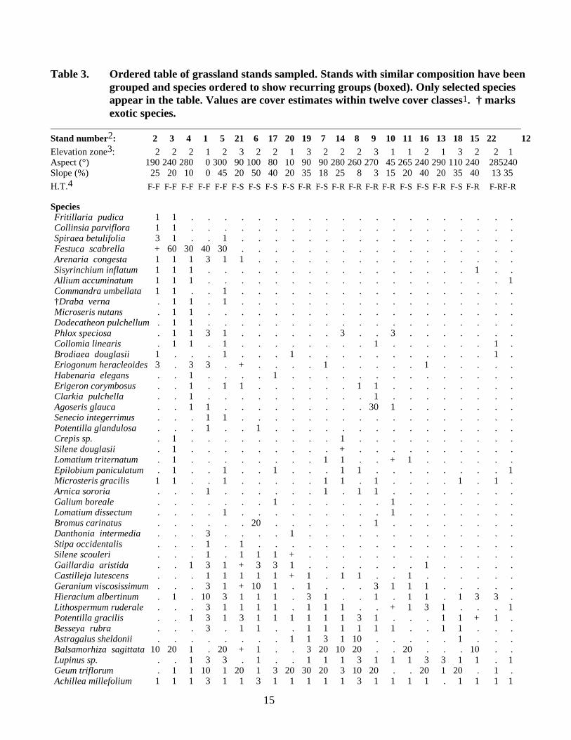
Species composition. Species with greater than 70% frequency were Festuca idahoensis,Agropyron spicatum, Koeleria cristata (prairie Junegrass), Achillea millefolium (yarrow),Geum triflorum (red geum), Potentilla gracilis (cinquefoil), and Lupinus spp. (lupine; Table3). Forb cover consisted primarily of Geum triflorum, Potentilla gracilis, Balsamorhizasagittata (arrowleaf balsamroot), and Hieracium albertinum (western hawkweed). The forbwith the highest importance was Geum triflorum. Stands 3,11,12, 13, and 22 would becharacterized as forb poor, with both a low diversity and cover of forbs.
The five Festuca scabrella stands are tied together only by the presence of F. scabrella,Arenaria congesta, and several very common species in the middle of Table 3. Stands 1 and5 are more similar to F. idahoensis stands 21, 6, and 17.
14
Stands 1, 5, 21, 6, and 17 have in common a six-species assemblage consisting of Gaillardiaaristida, Castilleja lutescens (yellow paintbrush), Geranium viscosissimum, Hieraciumalbertinum, Lithospermum ruderale (puccoon), and Potentilla gracilis. Four of these standsalso contain Silene scouleri (Scouler's catchfly), a species that only occurs in one other stand(20). Gaillardia and Silene appear to be indicator species for this group, which interestinglyincludes both Festuca idahoensis and F. scabrella associations. Senecio integerrimus andPotentilla glandulosa are restricted to this group. All but one of the stands in this group haveboth Symphoricarpos albus and Rosa spp. Stands 6 and 17 share six, highly restrictedspecies.
Stands 19, 7, 14, and 8 form a group based on 100% constancy of nine common species,combined with the presence of Astragalus sheldonii, which is nearly restricted to this group.These stands are also characterized by high cover of Balsamorhiza and Geum.
15
Table 3. Ordered table of grassland stands sampled. Stands with similar composition have beengrouped and species ordered to show recurring groups (boxed). Only selected speciesappear in the table. Values are cover estimates within twelve cover classes1. † marksexotic species.
Stand number2: 2 3 4 1 5 21 6 17 20 19 7 14 8 9 10 11 16 13 18 15 22 12Elevation zone3: 2 2 2 1 2 3 2 2 1 3 2 2 2 3 1 1 2 1 3 2 2 1Aspect (°) 190 240 280 0 300 90 100 80 10 90 90 280 260 270 45 265 240 290 110 240 285240Slope (%) 25 20 10 0 45 20 50 40 20 35 18 25 8 3 15 20 40 20 35 40 13 35
H.T.4 F-F F-F F-F F-F F-F F-S F-S F-S F-S F-R F-S F-R F-R F-R F-R F-S F-S F-R F-S F-R F-RF-R
SpeciesFritillaria pudica 1 1 . . . . . . . . . . . . . . . . . . . .Collinsia parviflora 1 1 . . . . . . . . . . . . . . . . . . . .Spiraea betulifolia 3 1 . . 1 . . . . . . . . . . . . . . . . .Festuca scabrella + 60 30 40 30 . . . . . . . . . . . . . . . . .Arenaria congesta 1 1 1 3 1 1 . . . . . . . . . . . . . . . .Sisyrinchium inflatum 1 1 1 . . . . . . . . . . . . . . . . 1 . .Allium accuminatum 1 1 1 . . . . . . . . . . . . . . . . . . 1Commandra umbellata 1 1 . . 1 . . . . . . . . . . . . . . . . .†Draba verna . 1 1 . 1 . . . . . . . . . . . . . . . . .Microseris nutans . 1 1 . . . . . . . . . . . . . . . . . . .Dodecatheon pulchellum. 1 1 . . . . . . . . . . . . . . . . . . .Phlox speciosa . 1 1 3 1 . . . . . . 3 . . 3 . . . . . . .Collomia linearis . 1 1 . 1 . . . . . . . . 1 . . . . . . 1 .Brodiaea douglasii 1 . . . 1 . . . 1 . . . . . . . . . . . 1 .Eriogonum heracleoides3 . 3 3 . + . . . . 1 . . . . . 1 . . . . .Habenaria elegans . . 1 . . . . 1 . . . . . . . . . . . . . .Erigeron corymbosus . . 1 . 1 1 . . . . . . 1 1 . . . . . . . .Clarkia pulchella . . 1 . . . . . . . . . . 1 . . . . . . . .Agoseris glauca . . 1 1 . . . . . . . . . 30 1 . . . . . . .Senecio integerrimus . . . 1 1 . . . . . . . . . . . . . . . . .Potentilla glandulosa . . . 1 . . 1 . . . . . . . . . . . . . . .Crepis sp. . 1 . . . . . . . . . 1 . . . . . . . . . .Silene douglasii . 1 . . . . . . . . . + . . . . . . . . . .Lomatium triternatum . 1 . . . . . . . . 1 1 . . + 1 . . . . . .Epilobium paniculatum . 1 . . 1 . . 1 . . . 1 1 . . . . . . . . 1Microsteris gracilis 1 1 . . 1 . . . . . 1 1 . 1 . . . . 1 . 1 .Arnica sororia . . . 1 . . . . . . 1 . 1 1 . . . . . . . .Galium boreale . . . . . . . 1 . . . . . . 1 . . . . . . .Lomatium dissectum . . . . 1 . . . . . . . . . 1 . . . . . . .Bromus carinatus . . . . . . 20 . . . . . . 1 . . . . . . . .Danthonia intermedia . . . 3 . . . . 1 . . . . . . . . . . . . .Stipa occidentalis . . . 1 . 1 . . . . . . . . . . . . . . . .Silene scouleri . . . 1 . 1 1 1 + . . . . . . . . . . . . .Gaillardia aristida . . 1 3 1 + 3 3 1 . . . . . . . 1 . . . . .Castilleja lutescens . . . 1 1 1 1 1 + 1 . 1 1 . . 1 . . . . . .Geranium viscosissimum. . . 3 1 + 10 1 . 1 . . . 3 1 1 1 . . . . .Hieracium albertinum . 1 . 10 3 1 1 1 . 3 1 . . 1 . 1 1 . 1 3 3 .Lithospermum ruderale . . . 3 1 1 1 1 . 1 1 1 . . + 1 3 1 . . . 1Potentilla gracilis . . 1 3 1 3 1 1 1 1 1 1 3 1 . . . 1 1 + 1 .Besseya rubra . . . 3 . 1 1 . . 1 1 1 1 1 1 . . 1 1 . . .Astragalus sheldonii . . . . . . . . 1 1 3 1 10 . . . . . 1 . . .Balsamorhiza sagittata10 20 1 . 20 + 1 . . 3 20 10 20 . . 20 . . . 10 . .Lupinus sp. . . 1 3 3 . 1 . . 1 1 1 3 1 1 1 3 3 1 1 . 1Geum triflorum . 1 1 10 1 20 1 3 20 30 20 3 10 20 . . 20 1 20 . 1 .Achillea millefolium 1 1 1 3 1 1 3 1 1 1 1 1 3 1 1 1 1 . 1 1 1 1
16
- Continued -Table 3 continued
Stand number: 2 3 4 1 5 21 6 17 20 19 7 14 8 9 10 11 16 13 18 15 22 12H.T.4 F-F F-F F-F F-F F-F F-S F-S F-S F-S F-R F-S F-R F-R F-R F-R F-S F-S F-R F-S F-R F-RF-R
Festuca idahoensis 50 3 10 20 30 80 30 3 80 40 70 70 90 80 90 20 80 20 90 20 70 . Agropyron spicatum 3 1 20 . 3 1 40 70 3 30 10 10 10 20 10 10 3 30 10 50 20 40 Koeleria cristata . . 1 3 1 1 10 1 1 1 3 3 10 10 3 . 1 1 1 + 3 . Poa secunda 1 1 1 . 1 . 10 . . . . 1 1 . . 1 . 3 . 1 . 1†Tragopogon dubius . . 1 1 1 . . 1 . 1 . 1 1 . + . . 1 1 1 1 1†Bromus spp. (annual) . . 1 . 1 . 1 . . 1 10 . 10 . 1 3 10 1 1 1 3 1†Ventenata dubia 1 1 30 1 1 . . . + 1 . . . . . 90 1 30 . 3 10 30 Lomatium marocarpum 1 . 1 . . . . . . . . . 1 . . . . . . . . 1 Symphoricarpos albus . 1 . . 1 + 10 3 1 . 1 . . . 1 1 1 + 1 . . . Rosa sp. . . . . 1 1 20 10 1 + . . . . 1 1 1 + . 1 . .†Poa pratensis . . . . . . 3 1 3 1 . 1 . . 1 1 1 3 1 . 1 . Penstemon attenuatus . . . . . 1 1 . . 1 . 1 3 . . . 3 . 1 . . . Haplopappus liatriformis. . . . . 20 1 . . 3 . . . . . + . + 1 . . . Solidago missouriensis . . . . . + 1 3 . 1 . . 3 . . 1 1 . . . . . Iris missouriensis . . . . . . 1 1 . 1 . . . . . . . . . . . . Linanthastrum nuttallii . . . . . . 1 3 . . . . . . . . . . . . . . Epilobium angustifolium . . . . . . 1 1 . . . . . . . . . . . . . . Valeriana edulis . . . . . . 1 1 . . . . . . . . . . . . . . Fragaria virginiana . . . . . . 1 1 . . . . . . . . . . . . . . Sidalcea oregana . . . . . . . 1 1 . . . . 1 . . . 1 . . . . Perideridia gairdneri . . . . . 1 . 1 1 . . . . 1 . . . . . . . . Crataegus douglasii . . . . . + 1 . . . . . . . . . . 1 . . . . Helianthella uniflora . . . . . + . 3 . . 1 . . . . + . . . 3 . . Zygodenus venenosus . . . . . 1 . . . 1 1 . 1 . . + 1 . . . . . Prunus virginiana . . . . . . . 3 . . . . . . + . . . . . . . Amelanchier alnifolia . . . . . . . 3 . 1 . . . . . . . . . . . .† Alysum alysoides . . . . . . . . . . 1 1 . . . . 1 . . 1 1 .†Agrostis interrupta . . . . . . . . . . . . 1 . 1 . . . . 1 . . Trifolium plumosum amp. . . . . . . . . . . . . 1 . . . . 1 . . .†Arenaria serpylifolia . . . . . . . . . . . . . . 1 . . 1 . 1 . . Apocynum androsaemifoium. . . . . . . . . . . . . . . . . . 1 . 3 1 Cover classes: <1% (1), 1-5% (3), 5-15% (10), 15-25% (20), 25-35% (30), 35-45% (40), 45-55% (50), 55-65% (60),
65-75% (70), 75-85% (80), 85-95% (90), and 95-100% (99). + = present outside plot.2 Stands were numbered consecutively for the purposes of this report. Place names, and plot i.d. numbers used in data
entry are given in the footnotes of Appendix 3.3 Elevation zones: <3400 ft (1); 3400-4000 ft (2); >4000 ft (3)4 Habitat types: F-F = Festuca scabrella-F. idahoensis; F-S = Festuca idahoensis-Symphoricarpos albus; F-R = Festuca
idahoensis-Rosa nutkana.
17
Little pattern is evident among species in the lower half of the table, except for the suite ofsix species that are common to stands 6 and 17, four of which occur nowhere else.Haplopappus liatriformis tends to occur with Penstemon attenuatus and Symphoricarposalbus and Rosa spp. tend to occur together, although not exclusively.
Classification of stands
Stands 1 through 5 are all located north of Moscow, and are considered to represent disjunctoccurrences of the Festuca scabrella (rough fescue) series common in western Montana.Within this series, Mueggler and Stewart (1980) describe a Festuca scabrella–Festucaidahoensis association dominated by a mixture of F. scabrella and F. idahoensis. All butstand 2 are dominated by F. scabrella. The Rathdrum Prairie site (stand 1) was unique in theabsence of Agropyron spicatum. These were the northernmost stands sampled and representthe southernmost extent of Festuca scabrella in Idaho. Daubenmire described three standson the eastern margin of the Palouse, in Washington, in which Festuca scabrella wasdominant or codominant, but did not differentiate these from the F. idahoensis series.
Using the classification of Daubenmire (1970), eight of the twenty-two prairie remnantssampled key to the Festuca idahoensis-Symphoricarpos albus (Idaho fescue-commonsnowberry) habitat type. The presence of dwarf individuals of Symphoricarpos in theforb/grass layer is diagnostic of this type. Stems of this rhizomatous shrub should be fairlyuniformly, although sparsely, scattered. Daubenmire states that there is always a taller shrubcomponent present as inclusion in the type which he treats as a phase of the association.Colonies of shrubs present as inclusions in our stands generally consisted of Rosa spp.,Symphoricarpos, or Crataegus douglasii (black hawthorn), but in many cases shrub thicketswere not present, possibly due to the small size of the stands.
The nine remaining stands (nos. 8, 9, 10, 12, 13, 14, 15, 19, and 22) represent Daubenmire'sFestuca idahoensis-Rosa nutkana (Idaho fescue–Nootka rose) association which is veryclose in composition to Festuca-Symphoricarpos except that Symphoricarpos is typicallyabsent and Rosa spp. are absent or sparse. Therefore the Festuca/Rosa type includes allstands lacking a shrub component .
Daubenmire considered the Festuca-Symphoricarpos type to be restricted to areas north ofthe Clearwater River with Festuca-Rosa replacing it to the south due to the rainshadoweffects of the Blue Mountains. Few prairie remnants remain north of the Clearwater. Of thetwo F. idahoensis stands sampled north of the river (11 and 15), one containedSymphoricarpos and the other did not. These two stands were unique however, in thepresence of the forb Apocynum androsaemifolium (dogbane) which was abundant in both. Atthe same time, seven stands sampled on the Camas Prairie, south of the Clearwater,contained Symphoricarpos, including stand 10 which was almost certainly one of the twostands sampled by Daubenmire in this area (Table 3). Since precipitation of the CamasPrairie is greater than that of the Palouse, the rainshadow effects proposed by Daubenmiremay only apply to the area between the Blue Mountains and the Snake River canyon inWashington.
18
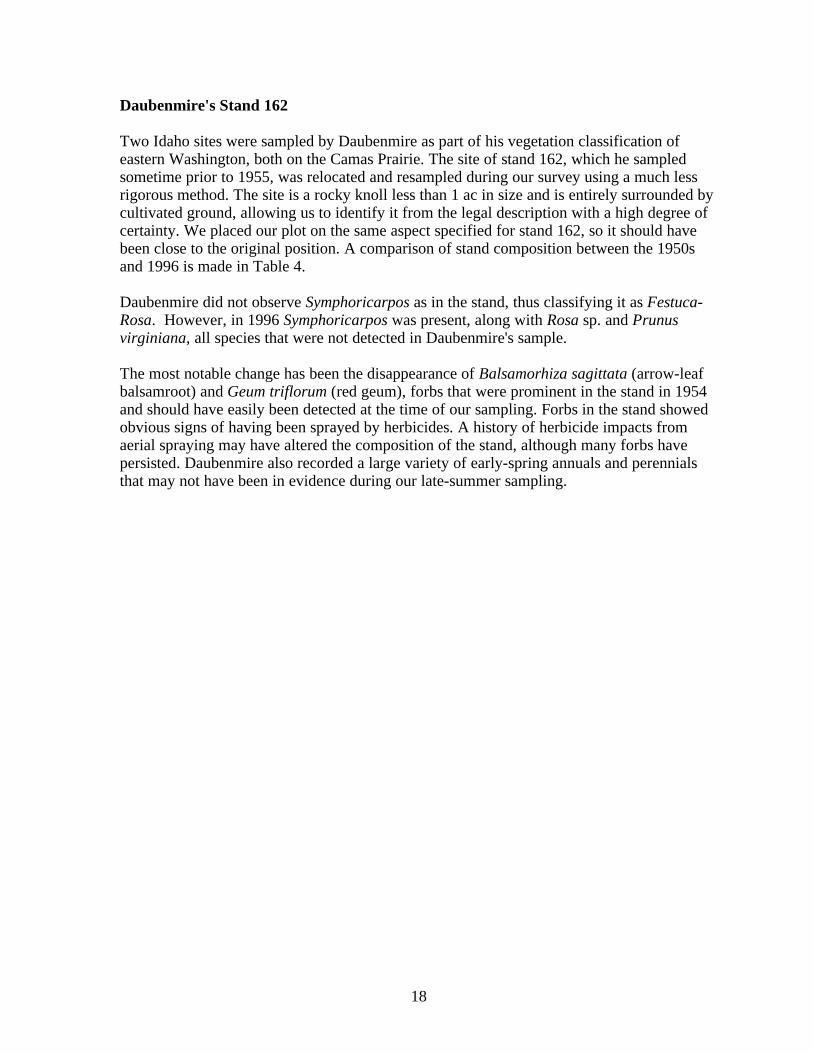
Daubenmire's Stand 162
Two Idaho sites were sampled by Daubenmire as part of his vegetation classification ofeastern Washington, both on the Camas Prairie. The site of stand 162, which he sampledsometime prior to 1955, was relocated and resampled during our survey using a much lessrigorous method. The site is a rocky knoll less than 1 ac in size and is entirely surrounded bycultivated ground, allowing us to identify it from the legal description with a high degree ofcertainty. We placed our plot on the same aspect specified for stand 162, so it should havebeen close to the original position. A comparison of stand composition between the 1950sand 1996 is made in Table 4.
Daubenmire did not observe Symphoricarpos as in the stand, thus classifying it as Festuca-Rosa. However, in 1996 Symphoricarpos was present, along with Rosa sp. and Prunusvirginiana, all species that were not detected in Daubenmire's sample.
The most notable change has been the disappearance of Balsamorhiza sagittata (arrow-leafbalsamroot) and Geum triflorum (red geum), forbs that were prominent in the stand in 1954and should have easily been detected at the time of our sampling. Forbs in the stand showedobvious signs of having been sprayed by herbicides. A history of herbicide impacts fromaerial spraying may have altered the composition of the stand, although many forbs havepersisted. Daubenmire also recorded a large variety of early-spring annuals and perennialsthat may not have been in evidence during our late-summer sampling.
19
Table 4. Comparison of community composition of Daubenmire's stand 162sampled in 1954, and again in 1996. Values for 1954 are means of 40microplots, to the nearest 1%. For 1996, percent cover is given as a range."P" indicates that the species was observed in the stand but did not occurin the plot.
'54 '96 '54 '96SHRUBS ANNUALS
Phlox speciosa 7 1-5 Agrostemma githago . PPrunus virginiana . P Agrostis interrupta . <1Rosa sp. . <1 Arenaria serpyllifolia 3 <1Symphoricarpos albus . <1 Bromus brizaeformis 2 <1
Bromus japonicus <.5 <1PERENNIAL GRASSES Bromus mollis 3 .
Bromus tectorum . PAgropyron spicatum 14 5-15 Cerastium viscosum <.5 .Festuca idahoensis 79 85-95 Collinsia parviflora 1 .Koeleria cristata 19 1-5 Draba verna 2 .Poa pratensis . <1 Epilobium paniculatum 1 .Poa secunda 5 . Lactuca serriola <.5 .
Microsteris gracilis <.5 .PERENNIAL FORBS Montia linearis <.5 .
Myosotis micrantha 1 .Achillea millefolium 1 <1 Stellaria nitens <.5 .Agoseris glauca . <1 Veronica arvensis <.5 .Balsamorhiza sagittata 6 .Besseya rubra 1 <1Calochortus elegans 2 <1Castilleja lutescens 1 .Claytonia lanceolata 1 .Crepis spp. 3 .Delphinium nuttallianum 1 .Dodecatheon pauciflorum 3Erigeron corymbosus 4 .Erythronium grandiflorum <.5 .Galium boreale . <1Geranium viscosissimum . <1Geum triflorum 21 .Hieracium cynoglossoides P .Lithophragma bulbifera 2 .Lithophragma parviflora <.5 .Lithospermum ruderale P PLomatium dissectum 9 <1Lomatium triternatum 1 PLupinus sp. 10 <1Mertensia longiflora <.5 .

20
Sisyrinchium inflatum 2 .Tragopogon dubius <.5 PWyethia amplexicaulis 14 5-15
21
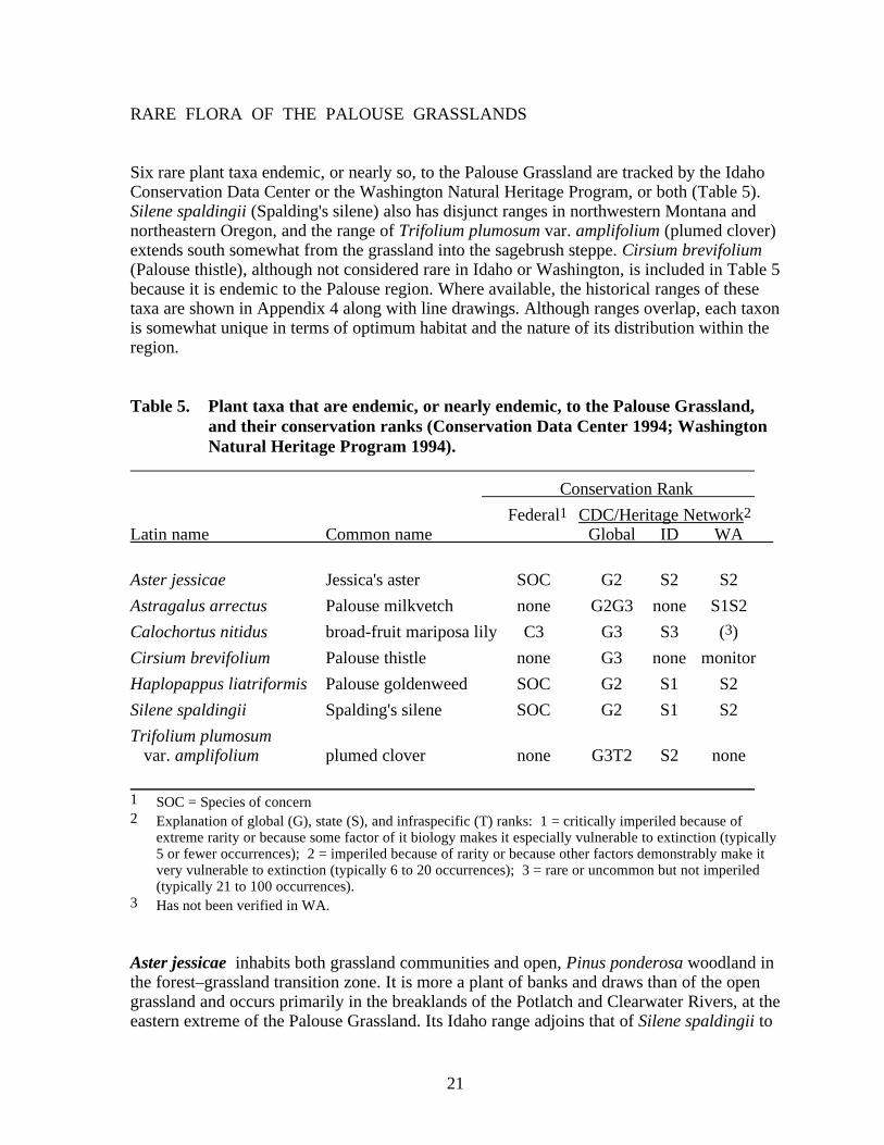
RARE FLORA OF THE PALOUSE GRASSLANDS
Six rare plant taxa endemic, or nearly so, to the Palouse Grassland are tracked by the IdahoConservation Data Center or the Washington Natural Heritage Program, or both (Table 5).Silene spaldingii (Spalding's silene) also has disjunct ranges in northwestern Montana andnortheastern Oregon, and the range of Trifolium plumosum var. amplifolium (plumed clover)extends south somewhat from the grassland into the sagebrush steppe. Cirsium brevifolium(Palouse thistle), although not considered rare in Idaho or Washington, is included in Table 5because it is endemic to the Palouse region. Where available, the historical ranges of thesetaxa are shown in Appendix 4 along with line drawings. Although ranges overlap, each taxonis somewhat unique in terms of optimum habitat and the nature of its distribution within theregion.
Table 5. Plant taxa that are endemic, or nearly endemic, to the Palouse Grassland,and their conservation ranks (Conservation Data Center 1994; WashingtonNatural Heritage Program 1994).
Conservation Rank
Federal1 CDC/Heritage Network2Latin name Common name Global ID WA
Aster jessicae Jessica's aster SOC G2 S2 S2
Astragalus arrectus Palouse milkvetch none G2G3 none S1S2
Calochortus nitidus broad-fruit mariposa lily C3 G3 S3 (3)
Cirsium brevifolium Palouse thistle none G3 none monitor
Haplopappus liatriformis Palouse goldenweed SOC G2 S1 S2
Silene spaldingii Spalding's silene SOC G2 S1 S2
Trifolium plumosum var. amplifolium plumed clover none G3T2 S2 none
1 SOC = Species of concern2 Explanation of global (G), state (S), and infraspecific (T) ranks: 1 = critically imperiled because of
extreme rarity or because some factor of it biology makes it especially vulnerable to extinction (typically5 or fewer occurrences); 2 = imperiled because of rarity or because other factors demonstrably make itvery vulnerable to extinction (typically 6 to 20 occurrences); 3 = rare or uncommon but not imperiled(typically 21 to 100 occurrences).
3 Has not been verified in WA.
Aster jessicae inhabits both grassland communities and open, Pinus ponderosa woodland inthe forest–grassland transition zone. It is more a plant of banks and draws than of the opengrassland and occurs primarily in the breaklands of the Potlatch and Clearwater Rivers, at theeastern extreme of the Palouse Grassland. Its Idaho range adjoins that of Silene spaldingii to
22
the west but the two do not overlap. It is much more tolerant of disturbance than the otherPalouse species and often persists along hedgerows and in old cemeteries.
Astragalus arrectus is not considered rare in Idaho, although much of its remaining habitatis rapidly being converted to exotic weeds. It occupies moister aspects within the prairie.
Calochortus nitidus has the widest range of the four, Federally ranked species, and the mostknown occurrences. It has a wider ecological amplitude than the other grassland taxa,ranging from the canyon grasslands, to forest openings well into the mountains. Although itonce occupied more mesic sites in the grassland, it is now restricted to grassy ridgecrests,canyon rims, and openings in dry conifer woodlands. It often occurs on very shallow soils.Because it extends into the lower, montane grasslands, its range overlaps public lands morethan those of the other taxa.
Cirsium brevifolium is a white-flowered thistle endemic to the Columbia Basin where itoccurs in Festuca idahoensis communities. It appears to be more characteristic of thePalouse than the Canyon Grassland, but has been only scantily collected. Because it is nottracked in Idaho, little is known of its current status. It occurs in prairie remnants but is notusually abundant. It occurred in only one of the 19 F. idahoensis stands sampled byDaubenmire.
Haplopappus liatriformis is endemic to the Palouse prairie and commonly occurs in evenvery small remnants if they are in excellent condition. Its range extends into the canyongrassland of the Snake River, but not into the mountains. Its frequency of occurrenceindicates that it was a common component of the Palouse grassland. Along with Silenespaldingii, it appears to rapidly disappear with increased disturbance or weed encroachment.
Silene spaldingii is the rarest plant in the above list. Although not strictly limited to thePalouse Grassland, it is endemic to the Pacific Northwest Bunchgrass biome. It is restrictedto slightly more mesic microsites within the grassland than H. liatriformis which alwaysoccurs with it in Idaho. In the native landscape S. spaldingii probably occupied draws andnorth hillslopes because it is always associated with shrubs. It occupies a slightly differentcommunity in the Canyon Grasslands (Lichthardt 1996). S. spaldingii has disjunctoccurrences, one in northwestern Montana, extending just barely into British Columbia, andanother in northeastern Oregon near Wallowa Lake. Most populations remaining in thePalouse and Camas Prairie areas are too small to be considered viable.
Trifolium plumosum var. amplifolium is sympatric with Haplopappus liatriformis, butmore common and abundant, possibly due to a higher tolerance for disturbance. It occurs asfar south as Washington County, Idaho, spilling over into the sagebrush steppe. The typevariety (T. plumosum var. plumosum) replaces it in Washington and Oregon and is alsoconsidered rare.

23
Threats
With a couple of exceptions noted above, the rare plants associated with the PacificNorthwest Bunchgrass grassland are mostly intolerant of disturbance and are found only inrelatively unaltered bunchgrass communities. Both natural and human disturbances can leadto weed invasion and eventual loss of the native community. Populations of rare speciesoccurring in prairie remnants are especially threatened by herbicide drift from aerial sprayingof adjoining fields. Some of the best remaining populations of these plants remain onfootslopes of mountains adjoining the prairie where they are threatened by conversion of theprairie for home construction. Isolated, small populations may also be subject to decreasedfitness due to inbreeding.
Protection
Because nearly all of the area which comprised the Palouse Grassland in Idaho is in privateor tribal ownership, and no grassland preserves exist, protection is only afforded these rareprairie species where they occur in the canyon grasslands. The canyon grasslands ecosystem,which is largely unsuitable for cultivated agriculture, affords several important conservationsites. These include BLM lands on which rare plants are protected, Fish and GameDepartment lands managed for wildlife, and The Nature Conservancy's Garden CreekPreserve. Non-ranked species such as Cirsium brevifolium are not protected or managed onpublic (Federal or State) lands.
Only Calochortus has significant populations on Federal lands, including National Forest andBureau of Land Management (BLM) lands. Palouse Grassland endemics with no protectedpopulations in Idaho are Aster jessicae, Astragalus arrectus, and Cirsium brevifolium.
24
CONSERVATION SITES
Palouse Grassland remnants with significant conservation value were documented using aSite Survey Form (Appendix 4). This form was designed by the CDC to facilitate entry ofinformation into a site basic record (SBR). SBRs document location, boundaries, biologicalelements, threats, and ranks for established and potential conservation sites (e.g., ResearchNatural Areas, Areas of Critical Environmental Concern, and preserves of The NatureConservancy). Thirteen conservation sites for grassland associations were identified during1996 surveys. General locations are shown in Appendix 1 (Map 3). Each site is given abiodiversity rank based on rarity of the biological elements represented, size, condition, andconnectivity to other natural vegetation. A rank of "B1" indicates the highest biodiversityvalue, "B5" the lowest. Biodiversity ranks are given in Table 6 for each grassland site, alongwith the plant communities and rare plant elements represented. The plant communitiesrepresented are also ranked for their size and condition. A rank of "A" indicates the highestconservation value, and "D" is lowest. SBRs for the sites are included in Appendix 5. Mostof the sites are in private ownership. The exceptions included about 60 acres of the ColdSpring Creek site that are in State ownership; Upper Meadow Creek, which is in Nez PerceTribal ownership; and McCroskey State Park.
The Palouse Grassland is dissected by breaklands of the Clearwater River and its majortributaries. Moister aspects in drainages as well as on north slopes, support coniferwoodland of Pinus ponderosa (Ponderosa pine) and Pseudotsuga menziesii (Douglas-fir).These conifer communities are often quite open with grassy understories and grasslandinclusions. Many of the rare plants associated with the Palouse Grassland range into thisgrassland/woodland ecotone. During our survey, we identified four such sites asconservation sites due primarily to the presence of rare plant populations. These sites aremost appropriately considered woodland types and are tabled separately (Table 7). All of thewoodland conservation sites are in private ownership.
Table 6. Proposed grassland conservation sites documented during a 1996 survey of remnant Palouse vegetation. Furtherinformation is stored in site basic records (SBR) in the CDC's Biological and Conservation Data System (BCD;Appendix 6). See text for explanation of ranks.
SBR Plant associations Rare plant Size Biodiversity# Site name present* Stand nos. elements (ac) Rank
Rank
064 Cold Spring Creek Feid–Syal C 6, 7, 16, 17Haplopappus liatriformis 70 B1Silene spaldingiiCalochortus nitidusTrifolium plumosum amplifolium
170 Ferdinand Antennas Feid–Ronu B 18 Haplopappus liatriformis 90 B2Trifolium plumosum amplifolium
196 Ferdinand Butte Feid–Syal A 19 Haplopappus liatriformis 85 B1Silene spaldingii
143 Liberty Butte Fesc–Feid A 4, 5 - 500 B1
155 McCroskey State Park Feid–Syal B - 400 B2Fesc–Feid BC 2, 3
2966 Rathdrum Prairie Fesc–Feid C 1 - 40 B3
204 Redbird Road Feid–Ronu C 13 Haplopappus liatriformis 10 B3
186 Reservation Road Feid–Syal BC 21 Haplopappus liatriformis 5 B3
212 South End Paradise Feid–Ronu A 15 Haplopappus liatriformis 160 B2Ridge Pipo/Feid A Calochortus nitidus
135 Talmaks East Feid–Ronu BC 9 Haplopappus liatriformis 2 B3Calochortus nitidus
218 Upper Meadow Creek Feid–Ronu B 22 Haplopappus liatriformis 30 B2Feid–Syal B Calochortus nitidus
213 Westside Tomer Butte Feid–Syal C 11, 12 Haplopappus liatriformis 150 B3
128 Windy Ridge Feid–Ronu BC 8 - 1 B3 * Abreviations use first two letters of genus name followed by first two letters of species name.
Table 7. Proposed woodland, rare plant conservation sites documented during a 1996 survey of remnant Palousevegetation. Further information is stored in the site basic records (SBR) in the CDC's Biological andConservation Data System (BCD; Appendix 6). See text for explanation of ranks.
SBR Plant associations Rare plant Biodiversity# Site name present* Stand nos. elements Size (ac) Rank
154 American Ridge Feid–Pose - Haplopappus liatriformis 5 B3Pipo/Feid
141 Cedar Creek Pipo/Feid - Aster jessicae 1100 B4
200 Chesley Railroad Feid–Pose - Haplopappus liatriformis 5 B2Pipo/Feid Aster jessicae
Calochortus nitidusLomatium dissectum dissectum
163 Tschantz Road Feid–Syal - Haplopappus liatriformis 2 B3 (Southwick) Aster jessicae
* Abreviations use first two letters of genus name followed by first two letters of species name.
25
REFERENCES
Aller, A.R., M.A. Fosberg, M.C. LaZelle, and A.L. Falen. 1981. Plant communities andsoils of north slopes in the Palouse Region of eastern Washington and northern Idaho.Northwest Science 55:248-262.
Bailey, R.G., compiler. 1995. Description of the ecoregions of the United States. 2ndedition. Miscellaneous Publication 1391. USDA, Forest Service, Washington, D.C.108 p. with separate map.
Barker, R.J. 1982. Soil survey of Idaho County area, Idaho, western part. USDA SoilConservation Service. US Government Printing Office, Washington, DC. 266 p plusmaps.
Barker, R.J., R.E. McDole, and G.H. Logan. 1983. Idaho soils atlas. University of IdahoPress, Moscow, ID. 148 p.
Boone, L. 1988. Idaho Place Names, a geographical dictionary. University of Idaho Press,Moscow, ID. 413 p.
Bourgeron, P.S., R.L. DeVelice, L.D. Engelking, G. Jones, and E. Muldavin. 1991. WHTFsite and community survey manual. Version91C. Western Heritage Task Force,Boulder, CO. 24p.
Buechner, H.K. 1953. Some biotic changes in the state of Washington, particularly duringthe century 1853-1953. Washington State College Research Studies 21:154-192.
Caicco, S.L. 1989. Manual to accompany the map of the existing vegetation of Idaho.Editorial draft. Unpublished report on file at the Conservation Data Center, IdahoDepartment of Fish and Game, Boise, ID. 114 p.
Caicco, S.L., J.M. Scott, B. Butterfield, and B. Csuti. 1995. A gap analysis of themanagement status of the vegetation of Idaho (U.S.A.). Conservation Biology 498-511.
Caldwell, H.H. 1961. The Palouse in diverse disciplines. Northwest Science 35:115-121.
Cronquist, A. 1955. Part 5, Compositae. In: Vascular plants of the Pacific Northwest, byC.L. Hitchcock, A. Cronquist, M. Ownbey, and J.W. Thompson. University ofWashington Press, Seattle.
Conservation Data Center. 1994. Rare, threatened, and endangered plants and animals ofIdaho. Third edition. Idaho Department of Fish and Game, Boise, Idaho. 39 p.
Daubenmire, R.F. 1940. Plant succession due to overgrazing in the Agropyron bunchgrassprairie of southeastern Washington. Ecology 21:55-64.
26
Daubenmire, R.F. 1942. An ecological study of the vegetation of southeastern Washingtonand adjacent Idaho. Ecological Monographs 12:53-79.
Daubenmire, R.F. 1946. The life zone problem in the northern Intermountain Region.Northwest Science 20:28-38.
Daubenmire, R.F. 1952. Plant geography of Idaho. Pages 1-17 in Flora of Idaho, R.J.Davis, Brigham Young University Press, Provo, UT.
Daubenmire, R.F. 1956. Climate as a determinant of vegetation distribution in easternWashington and northern Idaho. Ecological Monographs 26:131-154.
Daubenmire, R.F. 1970. Steppe vegetation of Washington. Technical Bulletin 62.Washington Agricultural Experiment Station, Washington State University, Pullman,WA. 89 p., plus appendices.
Ertter, B., and B. Moseley. 1992. Floristic regions of Idaho. Journal of the Idaho Academyof Science 28:5770.
Fenneman, N.M. 1931. Physiography of the western United States. McGraw-Hill BookCompany, Inc., New York, NY. 534 p.
Franklin, J.F., and C.T. Dyrness. 1988. Natural Vegetation of Oregon and Washington.Oregon State University Press, Corvallis, OR. 452 p.
Gamon, John. Botanist with the Washington Natural Heritage Program. Telephoneconversation on 8 November, 1996.
Gamon, J. and C.C. Lorain. 1991. Report on the status of Haplopappus liatriformis(Greene) St. John. Unpublished report for the U.S. Fish and Wildlife Service on file at:Idaho Fish and Game, Conservation Data Center, Boise. 45 p. plus appendices.
Grossman, D.H., K.L. Goodin, and C.L. Reuss, editors. 1994. Rare plant communities ofthe conterminous United States, an initial survey. The Nature Conservancy, Arlington,VA. 620 p.
Hitchcock, C.L. 1961a. Astragalus. Pages 197-272 in: Vascular plants of the PacificNorthwest. Part 3, by C.L. Hitchcock, A. Cronquist, M. Ownbey, and J.W. Thompson.University of Washington Press, Seattle.
Hitchcock, C.L. 1961b. Trifolium. Pages 354-372 in: Vascular plants of the PacificNorthwest. Part 3, by C.L. Hitchcock, A. Cronquist, M. Ownbey, and J.W. Thompson.University of Washington Press, Seattle.
Hitchcock, C.L. 1964. Silene. Pages 281-296 in: Vascular plants of the Pacific Northwest.Part 2, by C.L. Hitchcock, A. Cronquist, M. Ownbey, and J.W. Thompson. Universityof Washington Press, Seattle.
27
Humphrey, H.H. 1945. Common range forage types in the inland Pacific Northwest.Northwest Science 14:3-11.
Idaho Natural Heritage Program, Oregon Natural Heritage Data Base, and WashingtonNatural Heritage Program. 1986. Final report, Phase I, 1986 National NaturalLandmarks Program, Pacific Northwest Region, National Park Service. Unpublishedreport on file at the Conservation Data Center, Idaho Department of Fish and Game,Boise, ID. 48 p.
Johnson, C.G., and S.A. Simon. 1987. Plant associations of the Wallowa-Snake Province,Wallowa-Whitman, National Forest. R6-ECOL-TP-86. USDA Forest Service,Wallowa-Whitman National Forest, Baker City, OR. 399 p., plus appendices.
Lichthardt, J. 1996. Revised report on the conservation status of Silene spaldingii in Idaho.Draft report for the U.S. Fish and Wildlife Service on file at: Idaho Department of Fishand Game, Conservation Data Center, Boise.
Lorain, C.C. 1991. Report on the conservation status of Silene spaldingii in Idaho.Unpublished report to the Idaho Department of Parks and Recreation, through Section 6funding from the U.S. Fish and Wildlife Service. On file at: Idaho Department of Fishand Game, Conservation Data Center, Boise. 29 p. plus appendices.
Mancuso, M., and R. Moseley. 1994. Vegetation description, rare plant inventory, andvegetation monitoring for Craig Mountain, Idaho. DOE/BP-62547-1. USDOE,Bonneville Power Administration, Portland, OR. 146 p., plus appendices.
McNab, W.H., and P.E. Avers, compilers. 1994. Ecological subregions of the UnitedStates: Section descriptions. WO-WSA-5. USDA Forest Service, EcosystemManagement, Washington, D.C.
Mueggler and Stewart. 1980. Grassland and shrubland habitat types of western Montana.USDA Forest Service General Technical Report INT-66. 154 p.
Noss, R.F. 1995. What should endangered ecosystems mean to the Wildlands Project?Wild Earth 5(4):20-29.
Noss, R.F., E.T. LaRoe, and J.M. Scott. 1995. Endangered ecosystems of the United States:A preliminary assessment of loss and degradation. Biological Report 28. USDI,National Biological Service, Washington, D.C. 58 p.
Omernik, J.M., and A.L. Gallant. 1986. Ecoregions of the Pacific Northwest. EPA/600/3-86/033. U.S. Environmental Protection Agency, Environmental Research Laboratory,Corvallis, OR. 39 p. with map.
Owenby, M. 1969. Calochortus. Pages 765-779 in: Vascular plants of the PacificNorthwest. Part 1, by C.L. Hitchcock, A. Cronquist, M. Ownbey, and J.W. Thompson.University of Washington Press, Seattle.
28
Ross, S.H., and C.N. Savage. 1967. Idaho Earth Science. Earth Science Series 1. IdahoBureau of Mines and Geology, Moscow, ID. 271 p.
Rust, Steven K., Natural Areas Ecologist, Idaho Conservation Data Center. Telephoneconversation on October 24, 1996 .
Sims, P.L. 1988. Grasslands. Pages 265-286 in North American Terrestrial Vegetation,M.G. Barbour and W.D. Billings, eds., Cambridge University Press, New York, NY.
Stoddard, L.A. 1941. The Palouse grassland association in northern Utah. Ecology 22:158-163.
Taylor, D.W., J.M. Miller, and R.K. Moseley. 1990. Endangered plant survey for the PGT-PG&E pipeline expansion project, Idaho, Washington, Oregon, and California.BioSystems, Analysis, Inc., Santa Cruz, CA.
The Nature Conservancy, Idaho Natural Heritage Program, and Oregon Natural HeritageDatabase. 1987. Final report, Phase I, 1987 National Natural Landmark Project, PacificNorthwest Region, National Park Service. Unpublished report on file at theConservation Data Center, Idaho Department of Fish and Game, Boise, ID. 47 p.
Thiele, S.A., and J.M. Omernik. 1993. Subregions of the Columbia Plateau Ecoregion.Draft. Unpublished manuscript on file at the U.S. Environmental Protection Agency,Corvallis, OR. 19 p. with maps.
Tisdale, E.W. 1961. Ecologic changes in the Palouse. Northwest Science 35:134-138.
Tisdale, E.W. 1983. Grasslands of western North America: The Pacific NorthwestBunchgrass. Pages 223-245 in Grassland ecology and classification symposiumproceedings, A.C. Nicholson, A. McLean, and T.E. Baker, editors, Ministry of Forest,Province of British Columbia, Victoria, BC.
Tisdale, E.W. 1986a. Native vegetation of Idaho. Rangelands 8:202-207.
Tisdale, E.W. 1986b. Canyon grasslands and associated shrublands of west-central Idahoand adjacent areas. Bulletin Number 40. Forest, Wildlife and Range ExperimentStation, University of Idaho, Moscow, ID. 42 p.
Tisdale, E.W. 1994. Bluebunch wheatgrass SRM 101 and Idaho fescue SRM 102. Pages 1-2 in Rangeland Cover Types of the United States, T.N. Shiflet, editor, Society for RangeManagement, Denver, CO.
USDA-NRCS. 1996. Water resources database. USDA Natural Resources ConservationService.
Washington Natural Heritage Program. 1994. Endangered, threatened and sensitivevascular plants of Washington. Department of Natural Resources. Olympia. 52 p.
29
Weaver, J.E. 1914. Evaporation and plant succession in southeastern Washington andadjacent Idaho. Plant World 17:273-294.
Weaver, J.E., and F.E. Clements. 1938. Plant Ecology. McGraw-Hill Book Company, Inc.,New York, NY. 601 p.
Weisel, C.J. 1981. Soil survey of Kootenai County area, Idaho. USDA Soil ConservationService, Boise, ID. 255 p., plus maps.
Young, V.A. 1943. Changes in vegetation and soil of Palouse Prairie caused byovergrazing. Journal of Forestry 41:834-838.

30
APPENDICES NOT AVAILABLE ON THE WEB PAGECONTACT THE IDAHO DEPT. OF FISH AND GAME, CONSERVATION DATA
CENTER FOR THIS INFORMATION