Embed Size (px)
Citation preview

Reviewed research article
Paleomagnetic observations at three locations in the Pleistocenelava sequences of southwest and south Iceland
Leó KristjánssonInstitute of Earth Sciences, Science Institute, University of Iceland, Sturlugata 7, 101 Reykjavík, Iceland
Abstract — Magnetic polarity measurements on lava samples were introduced in the 1950s as an aid in strati-graphic research in Iceland, and applied by T. Einarsson especially on Pleistocene sequences in southwestand south Iceland. However, the stratigraphy of these sequences is often complex, and Einarsson’s mappinghas only been followed up to a limited extent. The present detailed laboratory study on magnetic remanencedirections in lava flows is focused on three locations within the above region. In two of these locations (insouthwest Iceland), profiles spanning the boundary between the polarity zones named R2 and N2 by Einarssonwere sampled. The potential of using this boundary for correlation over short distances was confirmed. In athird location (in south Iceland), three normal-polarity zones are present in a 500 m thick lava and sedimentsequence of dominantly reverse polarity. The stability and within-lava agreement of primary remanence vectorsis generally excellent. Remanence directions in successive lava units are in many cases very similar, indicat-ing that the volcanism was episodic. In comparison to geomagnetic poles obtained in previous paleomagneticcollections of older lava series in Iceland, the poles derived from these and other Pleistocene lavas are rarelysituated in low latitudes.
INTRODUCTION – PREVIOUS WORK
In Iceland, research on the age and stratigraphy oflava sequences is fundamental to many other earthscience studies of local and regional interest. Of-ten it is also relevant to global processes such asclimate changes. One of the methods employed instratigraphic research in Iceland since the early 1950s(Hospers, 1953) is the measurement of the direc-tion vectors of remanent magnetization (remanence)in lava flows. The remanence acquired by the rockon cooling, which has a direction more or less identi-cal to that of the ambient geomagnetic field, may re-main stable for tens of millions of years (m.y.). Animportant aspect of this research concerns completereversals of the geomagnetic field which have takenplace at irregular intervals. In the first half of the 20thcentury, these intervals were thought to be millions of
years in duration. Hospers (1953) introduced a usefulconcept called a "virtual geomagnetic pole" (VGP).This is the magnetic (south) pole corresponding to afield direction observed somewhere on the Earth, onthe assumption that the geomagnetic field is due to adipole (resembling a short bar magnet) at its center.The slow "secular variation" of the geomagnetic fieldwas thought of as a semi-regular wobbling of the VGParound the geographic pole between abrupt reversalsof polarity.
Following the work of Hospers, application of thepaleomagnetic method in Iceland was taken up byEinarsson and Sigurgeirsson (1955). Einarsson car-ried out measurements of the polarity of basalt lavaflows and other bodies with a field compass, mostly inhillside profiles in many parts of the country. Descrip-tions of the strata, their magnetic polarity, and geolog-
JÖKULL No. 60 149

L. Kristjánsson
ical interpretation appeared in several of his publica-tions, e.g., Einarsson (1957, 1962). Einarsson foundthat each series (zone) of lavas having "normal" or"reverse" polarity often consisted of tens of lava flows.He attempted to set up a scheme for the consecutivenumbering of such polarity zones, especially in thestrata emplaced during the cold climates of the last 3m.y. Thus, zone N1 corresponded to the present mag-netic epoch, R1 contained lavas from the last reverseepoch, and so on. Each of these zones varied in thick-ness between locations, but N2 and R2 were of theorder of 150 m and 300 m thick respectively, N3 wasonly some 50 m, and R3 was 500 m.
Detailed work on worldwide volcanic sites datedby the potassium-argon (K-Ar) method in the 1960s,augmented by interpretation of magnetic anomaly lin-eations parallel to ocean ridges, revealed that on av-erage at least 3–4 reversals had occurred every mil-lion years in the Cenozoic era. Several versions of a"geomagnetic polarity time scale" for these reversalshave been published, with each revision incorporat-ing additional reversal events named subchrons andcryptochrons (Ogg and Smith, 2004). It has been con-cluded from research on sedimentary and volcanic se-quences that at least ten such short events may haveoccurred in the current normal-polarity epoch (nowknown as the Brunhes chron) which began at 0.78Ma, and the situation may be analogous for previouschrons. The secular variation has also been found toinclude many "excursions" of the VGP’s position tolow latitudes.
Due to this increasing complexity in our knowl-edge of the geomagnetic field behaviour, as well asto the scarcity of radiometric age determinations sofar obtained from Icelandic lavas, any correspondencebetween Einarsson’s polarity zones and the geomag-netic polarity time scale is still uncertain. Einarsson(1962, p. 70) was also aware that one or more polarityzones might be missing in some of his profiles due toeruption rate variations, hiatuses or erosion. In somelocations, the N2 might be tentatively identified withthe Jaramillo normal-polarity subchron at 0.99–1.07Ma, i.e., late in the Matuyama reverse magnetic chronwhich is supposed to span the interval 0.78–2.58 Maago (Ogg and Smith, 2004). However, in other places
N2 could contain volcanics from an older long sub-chron in the Matuyama, namely the Olduvai at 1.78–1.95 Ma. In southwest Iceland, this correlation findssome support in the K-Ar dating of a presumed N2unit (Kristjánsson et al., 1980) which yielded an ageof about 1.9 Ma (when recalculated with the decayconstants used by Ogg and Smith). N3 may accord-ingly be the Reunion subchron which lasted between2.13–2.15 Ma ago.
In addition to collaborating with Einarsson on po-larity measurements in lava profiles, Sigurgeirsson(1957) designed a laboratory instrument for the ac-curate measurement of the primary remanence direc-tions in hand samples. Sigurgeirsson carried out anumber of such determinations, mostly on lavas nearthe boundaries between polarity zones in Einarsson’sprofiles in southwest Iceland. The best known of Sig-urgeirsson’s directional measurements are those at theR3-N3 boundary in various locations south of Hval-fjörður (H of Figure 1), resampled by Kristjánssonet al. (1980). Kristjánsson and Sigurgeirsson (1993),and others. This established that virtual poles formedan irregular path passing through low latitudes duringthe reversals, rather than the dipole simply decreasingto zero and then growing in the opposite sense whilestaying in near-axial orientation. It has also becomeclear from Icelandic data that the field intensity is re-duced during the reversal process, with the dipole fieldbecoming weaker than non-dipole field componentswhen the VGP latitude is less than 25◦ or so (Figure 9of Kristjánsson, 2008).
In 1964 a new stage began in paleomagnetic re-search on Icelandic lava sequences. That summer, alarge collection of oriented drill cores was acquiredby Doell (1972), mostly in Tjörnes (T of Figure 1)and the Snæfellsnes peninsula (S of Figure 1). An-other collection effort was carried out in 1964–1965 insouthwest and east Iceland by a U.K. – Icelandic ex-pedition. In southwest Iceland the expedition sampledten profiles of Pliocene and Pleistocene age, mappedby T. Einarsson around the Hvalfjörður fjord. Thepublished account of this study (Wilson et al., 1972)was somewhat incomplete. Firstly, the altitudes oflava boundaries mapped by Einarsson were shown indiagrams, but very little information on the lithology
150 JÖKULL No. 60

Paleomagnetic observations in SW- and S-Iceland
Figure 1. Index map of Iceland: the active volcanic zones (with basement outcrops of mostly less than 0.78Ma age) are shaded. Locations of the surveys reported here are indicated, as well as some small areas whereprevious paleomagnetic sampling on lava flows of less than 3 Ma age has been carried out. S = Snæfellsnespeninsula, H = Hvalfjörður, T = Tjörnes promontory, Sk = Skaftafell area, E = Eyjafjöll, I = Ingólfsfjall, J = areain Jökuldalur containing profiles of Watkins et al. (1975) and Udagawa et al. (1999), Þ = area in Þjórsárdalurcontaining profiles of Kristjánsson et al. (1998). – Kort af Íslandi, virku gosbeltin eru skyggð. Svæði sem fjallaðer um hér og í nokkrum fyrri greinum um svipað efni eru afmörkuð lauslega.
of the lavas or of the sediments between them waspresented. Secondly, the paleomagnetic results werenot presented in detail, but merely polarity informa-tion. Some maps of VGP positions were publishedlater by the group, and the present author was given aprintout of the remanence directions from all profiles.As only two samples were collected in each lava flow,it is necessary to re-sample the profiles of Wilson etal. (1972) if one wishes to obtain lava-mean directionvalues that can be used for studies of the geomagneticsecular variation.
Several laboratory paleomagnetic studies havebeen carried out in Iceland since the early 1970’s,in some cases accompanied by radiometric dating.
Projects involving long composite sections of pro-files in stratigraphic succession were reviewed byKristjánsson and Jónsson (2007) and Kristjánsson(2009). One of these sections (Kristjánsson et al.,1980) overlaps with the areas in southwest Icelandcovered by Einarsson (1957,1962). A number of otherpaleomagnetic studies have been on a smaller scale.Among them are studies on lavas mostly less than 2Ma old, published by Watkins et al. (1975) and Uda-gawa et al. (1999) in Jökuldalur (J), Kristjánsson etal. (1988) in Eyjafjöll (E), Tjörnes (T) and Ingólfsfjall(I), Eiríksson et al. (1990) in Tjörnes, Kristjánsson etal. (1998) in Þjórsárdalur (Þ), and Helgason and Dun-can (2001) in the Skaftafell area (Sk), see Figure 1.
JÖKULL No. 60 151

L. Kristjánsson
Their results along with magnetic polarity measure-ments made in the field have aided in the compilationof regional geological maps of surface outcrops, suchas the recent map by Sæmundsson et al. (2010).
THE PRESENT PROJECT
Although some of the publications listed in thelast paragraph (as well as various student thesesand institute reports of limited circulation) have fol-lowed up on details of T. Einarsson’s paleomagnetic-stratigraphic mapping efforts, much remains to bedone in that field. The work described in this pa-per continues some of Einarsson’s (1962) studies andwill hopefully stimulate others to extend them further.Three isolated areas were chosen, all presumably be-longing to the Matuyama geomagnetic chron. Thesewere in the Brynjudalur valley south of Hvalfjörður(Figures 1 and 2), on both sides of the Kjósarskarðpass (Figures 1 and 4), and near the Fossnes farm inthe Þjórsárdalur valley (Figures 1 and 7). As in previ-ous studies by the author and his collaborators in otherprofiles of Brunhes-Matuyama age (e.g. Kristjánssonet al., 1988; Kristjánsson and Sigurgeirsson, 1993),the chief aim of the project was to locate geomagneticexcursions and boundaries of polarity zones. Thesemight be promising for radiometric dating and for useas stratigraphic markers across larger areas.
Another motive for sampling these profiles was toobtain new data on the long-term secular variation ofthe geomagnetic field in the Pleistocene. The angu-lar standard deviation (a.s.d.) of VGPs from Icelandiclavas seems to have had a significantly smaller am-plitude in the last few million years than for instanceduring the period 10–15 Ma ago (Kristjánsson, 2008).Few if any other parts of the world seem capable ofproviding coverage of comparable intervals with mag-netic direction data of comparable quality and quan-tity. Therefore, it is still not known whether this re-duction in the a.s.d. is related to changes in other prop-erties of the geomagnetic field such as its reversal fre-quency or its long-term mean intensity.
METHODSSampling of 25-mm diameter cores was carried outwith a two-stroke gasoline-powered drill. The coreswere oriented in situ with a Brunton compass, usingsightings on the Sun or distant geographic objects forazimuth reference. At least four core samples werecollected at each site. All remanence measurementson 21 mm long specimens from these cores weremade with an Institut Dr. Förster four-probe fluxgatemagnetometer. Many samples contained significantviscous magnetization (VRM) whose intensity couldeven exceed that of the primary remanence. How-ever, this VRM was easily removed by stepwise treat-ment in a Molspin alternating-field demagnetizer. Thepeak fields applied were 10, 15, 20 and 25 milli-Tesla.A 30 mT step was also added in the Þórisgil andKjósarskarð profiles, but it turned out to be unnec-essary. An average direction was computed for eachlava after each step, and the average with the smallest95% confidence angle (α95) was selected for inclu-sion in Appendix 1. The lava flows in all the sampledprofiles generally carry a very stable primary rema-nence of moderate intensity, giving excellent direc-tional agreement between the core samples. Only afew samples were rejected in each of the three areas,due to instability, suspected orientation errors or out-crop movement.
In the diagrams of the profiles, the sampledlavas have been classified roughly into lithologi-cal categories based on field criteria and inspectionof the cores: tholeiites, olivine tholeiites, feldspar-porphyritic flows, and andesites. The clastic units inthe profiles are also described in broad terms only.
PROFILE WB IN ÞÓRISGIL,BRYNJUDALUR, SW-ICELAND
A stratigraphic profile of the Þórisgil gully (Figure 2)in the Brynjudalur valley south of Hvalfjörður waspublished in Figure 31 of Einarsson (1962). It indi-cates that the lower part of the profile is occupied bythe R2 series. This is followed by a 10 m layer of sec-ondary breccia and fine conglomerate at an unspeci-fied altitude and then 15 lava flows belonging to theN2 zone on the slopes of the Botnssúlur mountain.
152 JÖKULL No. 60

Paleomagnetic observations in SW- and S-Iceland
Figure 2. Location of the surroundings of profile WB, with flows 1–8 in the Þórisgil gully and 9–18 along thesame stream to the slopes of Botnssúlur. – Lega jarðlagasniðs WB í Þórisgili og ánni upp af því.
The profile was subsequently sampled by Wilson etal. (1972) who named it WB. Wilson et al. (1972, p.460) sketch the altitudes of flow boundaries, both asobtained by Einarsson and as derived from observa-tions during the sampling. Their results which do notagree very well, are not reproduced here. The R2-N2boundary in these sketches occurs at respectively 380and 440 m.
The present author has resampled the R2-series aswell as the four lowest lavas of the N2. The strati-graphic column in Figure 3 is based on his notes. Al-titudes were measured with a handheld GPS receiver,to an accuracy of some 5 m. The mean primary re-manence directions and intensities obtained are listedin Appendix 1. The directions have been corrected fortectonic tilt which is estimated to decrease from 6◦ atthe base to 3◦ at the top, with a downdip direction of130◦ east.
Successive directions are found to be grouped toa considerable extent. Thus they are very similar in
flows WB 1 and 2, also almost constant in flows 6–11,and again very similar in flows 12–13. This probablyis due to episodes of rapid buildup. Flow WB 6 is ofunusual appearance and has unusual magnetic prop-erties with very low remanence intensity and suscep-tibility, pointing to the presence of a highly oxidizedmagnetic mineral component. This flow (along withflows WB 1 and 8) also had a high coercivity of rema-nence, the median destructive field of the remanencein its samples being 50 mT or more while in the otherlavas in this study it mostly ranged from less than 10to 35 mT.
There do not seem to be any lava flows of in-termediate directions present at the reverse-to-normalboundary which coincides with a thick intermittentlyexposed layer of tuff and hyaloclastite. Einarsson(1962, Fig. 32) describes a series of some 11 N2 "flowunits" above a tillite which presumably overlies thelava numbered WB 18 here; this series was not sam-pled by Wilson et al. (1972) or in the present survey.
JÖKULL No. 60 153
L. Kristjánsson
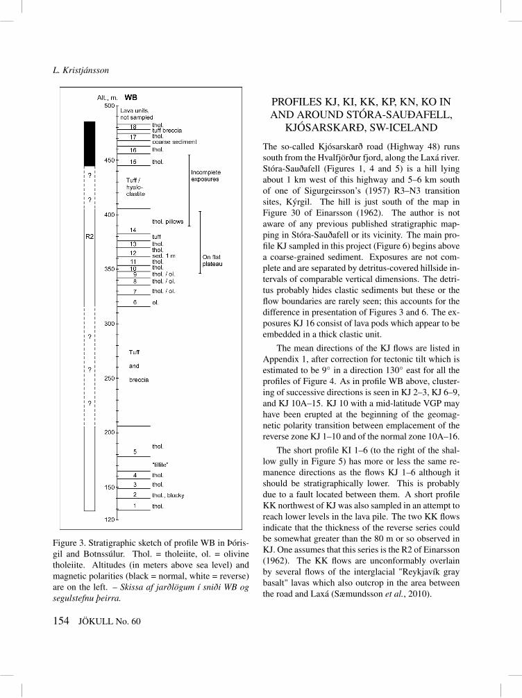
Figure 3. Stratigraphic sketch of profile WB in Þóris-gil and Botnssúlur. Thol. = tholeiite, ol. = olivinetholeiite. Altitudes (in meters above sea level) andmagnetic polarities (black = normal, white = reverse)are on the left. – Skissa af jarðlögum í sniði WB ogsegulstefnu þeirra.
PROFILES KJ, KI, KK, KP, KN, KO INAND AROUND STÓRA-SAUÐAFELL,
KJÓSARSKARÐ, SW-ICELAND
The so-called Kjósarskarð road (Highway 48) runssouth from the Hvalfjörður fjord, along the Laxá river.Stóra-Sauðafell (Figures 1, 4 and 5) is a hill lyingabout 1 km west of this highway and 5–6 km southof one of Sigurgeirsson’s (1957) R3–N3 transitionsites, Kýrgil. The hill is just south of the map inFigure 30 of Einarsson (1962). The author is notaware of any previous published stratigraphic map-ping in Stóra-Sauðafell or its vicinity. The main pro-file KJ sampled in this project (Figure 6) begins abovea coarse-grained sediment. Exposures are not com-plete and are separated by detritus-covered hillside in-tervals of comparable vertical dimensions. The detri-tus probably hides clastic sediments but these or theflow boundaries are rarely seen; this accounts for thedifference in presentation of Figures 3 and 6. The ex-posures KJ 16 consist of lava pods which appear to beembedded in a thick clastic unit.
The mean directions of the KJ flows are listed inAppendix 1, after correction for tectonic tilt which isestimated to be 9◦ in a direction 130◦ east for all theprofiles of Figure 4. As in profile WB above, cluster-ing of successive directions is seen in KJ 2–3, KJ 6–9,and KJ 10A–15. KJ 10 with a mid-latitude VGP mayhave been erupted at the beginning of the geomag-netic polarity transition between emplacement of thereverse zone KJ 1–10 and of the normal zone 10A–16.
The short profile KI 1–6 (to the right of the shal-low gully in Figure 5) has more or less the same re-manence directions as the flows KJ 1–6 although itshould be stratigraphically lower. This is probablydue to a fault located between them. A short profileKK northwest of KJ was also sampled in an attempt toreach lower levels in the lava pile. The two KK flowsindicate that the thickness of the reverse series couldbe somewhat greater than the 80 m or so observed inKJ. One assumes that this series is the R2 of Einarsson(1962). The KK flows are unconformably overlainby several flows of the interglacial "Reykjavík graybasalt" lavas which also outcrop in the area betweenthe road and Laxá (Sæmundsson et al., 2010).
154 JÖKULL No. 60

Paleomagnetic observations in SW- and S-Iceland
Figure 4. Location of pro-files in Stóra-Sauðafell andits vicinity. A fault betweenprofiles KJ and KI (Sæ-mundsson et al., 2010) isshown. – Staðsetning sniðaí Stóra-Sauðafelli og um-hverfis það í Kjósarskarði.
Figure 5. Stóra-Sauðafellseen from road 48. ProfileKJ lies near the middle ofthe photo and KI is to theright of the shallow gully,both beginning at the lowestlava exposures. – Ljósmyndaf Stóra-Sauðafelli, snið KJer þar nálægt miðju og KItil hægri.
The profile KP (Figures 4 and 6) begins at a sharpbend in a stream west of the northern end of Stóra-Sauðafell. The bottom flow KP 1 is well exposed buthighly cracked so that it was impossible to collect coresamples from it. However, fluxgate measurements inthe field gave a reversed polarity. The lithology ofthis flow is characteristic of andesite although no suchrocks are shown at that locality in the geological mapby Sæmundsson et al. (2010). Some of the other flowsin profile KP have textures reminiscent of quartz-richtholeiite or even andesite. The top lava which is theonly normally magnetized unit in the profile, presum-ably correlates with the normal-polarity series KJ 10A
to 16. Successive directions are in some cases seen tobe very similar, especially in KP 4–5 and 10–13.
Another two profiles KO and KN were sampled inthe hill Stóröxl across the Laxá river (Figures 4 and6). The lower slopes of this hill are largely covered bygravel with occasional exposures including acid tuffand the acid or intermediate lavas KO 2A (where onlyone reversely magnetized core sample was collected)and KO 2B. It is likely to belong to the same volcanicphase as KP 1. A layer of coarse tuff is encounteredat 265 m altitude underneath profile KN. On top ofthe tuff there are several lava flows, the lowest onepetering out towards the north. Six were sampled in
JÖKULL No. 60 155

L. Kristjánsson
Figure 6. Stratigraphic sketch of the profiles in and around Stóra-Sauðafell. Altitudes of the sampling spots areindicated, along with lithological information and the thicknesses of lava exposures at these spots. – Jarðlög ísniðunum á 4. mynd.
this profile; exposures become unsatisfactory higherup. The bottom four lavas KN 1–4 are reversely mag-netized, and the top two are normal (Appendix 1).Within each zone the remanence directions are verysimilar. It is most likely that this polarity reversal isthe same as is found in KJ in Stóra-Sauðafell and inKP. The presence of the porphyritic flows KN 3 andKJ 5 which have similar directions of magnetization,could support this correlation. In Stóröxl and within4 km to the north, the R2 polarity zone may havemerged with R3 (Einarsson, 1962, Figure 30) due todisappearance of the thin N3 zone.
PROFILES HR AND FO AT FOSSNES,ÞJÓRSÁRDALUR, S-ICELAND
The "Hreppar Formation" lies between the two activevolcanic zones in south Iceland (Figure 1). Geologicalresearch in that area began around 1900 (e.g., Pjet-ursson, 1905) but it has been quite sporadic and inpart recorded only in institute reports and undergrad-uate theses. The formation consists of subaerially em-placed basalt lavas intercalated with pillow lavas andhyaloclastites, indicative of subglacial or subaqueouseruptions. Other clastic deposits indicating cold cli-
156 JÖKULL No. 60

Paleomagnetic observations in SW- and S-Iceland
mate are also abundant, and so is evidence of land-scapes formed by erosion. This along with complextectonics (Khodayar and Franzson, 2004, 2007) and ascarcity of radiometric age determinations has madeit difficult to reconstruct the geological history of theHreppar region. Kristjánsson et al. (1998) review pre-vious research within the region by Einarsson (1962,p. 132–142), Friðleifsson et al. (1980) and others.They also describe their study of stratigraphy and pa-leomagnetic polarities in several short sampling pro-files along the Þjórsá river (roughly in the area Þ ofFigure 1). From the polarities and K-Ar age determi-nations on four lava flows, Kristjánsson et al. (1998)concluded that a composite section of some 500–600
m thickness made up from these profiles covers theage interval from 2.2 Ma to less than 0.8 Ma. Theyoungest outcrops sampled may be 0.2 Ma old.
A paleomagnetic survey to supplement the resultsof Kristjánsson et al. (1998) was carried out in two ad-jacent and overlapping profiles HR and FO (Figure 7)near the Fossnes farm in Þjórsárdalur, totalling some500 m in thickness. The work took place in conjunc-tion with geological mapping of the surrounding areaby Á. Geirsdóttir and Th. Thordarson (ms. in prepa-ration) which focused both on the volcanic stratigra-phy of this area, and on clastic sedimentary deposits(Geirsdóttir et al., 1993, 1994). Sampling was alsoundertaken in nearby hills (Núpsfjall, Þjórsárholts-
Figure 7. Approximate location of profilesHR and FO. The lava units HR 5A to 5Iwere sampled from the road at Þjórsá tojust beyond the tributary Þverá as shown.The series HR 5L to 5V, 7, 9 and 11 weresampled successively along the west bankof Þverá up to near the top of the map.Lavas FO 20 to 40 were sampled along theeast bank of Þverá, from near HR 5V tothe top of the map. – Lauslegt kort af stað-setningu sniðanna HR og FO við Fossnesí Þjórsárdal.
JÖKULL No. 60 157

L. Kristjánsson
holt, Gaukshöfði and Skriðufell, some 30 lava units intotal). However, magnetic results obtained from theseare not reported here, as they have not yet been fittedinto a common stratigraphic scheme. The remanencedirections given in Appendix 1 have been correctedfor tectonic tilt which is estimated to average 5◦ witha down-dip direction of 30◦ east (Friðleifsson et al.,1980; Á. Guðmundsson, pers. comm. 1992; Khoda-yar and Franzson, 2004).
A short description of some features of the twosampled profiles, based on unpublished informationkindly supplied by Á. Guðmundsson, Á. Geirsdótt-ir and Th. Thordarson (pers. comm. 1992–2001), isas follows (Figure 8). According to the numberingof Friðleifsson et al. (1980), the Stratigraphic UnitsHR 5, 7, 9 and 11 consist mostly of lavas of tholeiiticlithology, while their Units 6, 8, 10 and 12 are ratherheterogeneous tuffaceous sediments not differentiatedin Figure 8. The bottom one-third of the compositecolumn is composed of the series HR 5A through 5V,i.e., Unit 5 of Friðleifsson et al. (1980) which can betraced across several kilometers in the area. 11 outof over 20 mostly thin flows were sampled, 5A to5H south of the Þverá stream and 5I to 5V along it.All were reversely magnetized except the top one 5Vwhich is a lava lake. Nearby flows FO 20 and FO 21on the east side of Þverá are also of normal polarity.Then we find sandstone and diamictite, a couple of re-versely magnetized flows FO 22, 23, and FO 24 witha transitional direction on the boundary with anothernormal-polarity series of medium-grained basalts FO25–32. It is not certain where some of the HR flows(sampled west of the stream above HR 5V) fit into theFO profile east of the stream, but HR 7A probably be-longs to the same reverse zone as FO 22 whereas thenormal-polarity units HR 9A,B,C,E correspond to thetop part of FO 25–32. Although no faults are showncrossing the stream in maps accompanying the reportsof Friðleifsson et al. (1980) and Khodayar and Franz-son (2004), a fault zone may lie between flows FO 32and 36B. Repetition in the lava sequence at this levelis inferred from the similarity of the remanence direc-tions in the reverse flows FO 33 and 34 with those inFO 35 (and HR 9D) and 36A respectively. At leasttwo normal-polarity flows FO 36B, 37 are also found
here. Finally, sediments containing the reversely mag-netized FD 38 (a picrite) and HR 11A,B is in turnoverlain by the normal-polarity lavas FD 39,40.
158 JÖKULL No. 60

Paleomagnetic observations in SW- and S-Iceland
Figure 8. Stratigraphy of profiles HR and FO, sim-plified from an annotated drawing by Á. Geirsdóttir(pers. comm., 1996), with additional input from Th.Thordarson (pers. comm. 1996, 2001), Á. Guðmunds-son (pers. comm., 1992) and the author. The magneticpolarities of the lavas are mostly based on laboratorymeasurements but partly on fluxgate measurements inthe field. Thin sedimentary layers are assumed to havethe same polarity as adjacent lavas. The numbers onthe left-hand side refer to cumulative thicknesses (inmeters), not altitudes. – Jarðlög í sniðunum HR ogFO, ásamt segulstefnu í þeim. Súlan er einfölduð úrteikningu frá Áslaugu Geirsdóttur og Þorvaldi Þórð-arsyni. Tölur eiga við samanlagðar þykktir, ekki hæð.
The scheme presented in Figure 8 is a tentativeone, as exposures in the Fossnes profiles are some-what incomplete. Much additional work is thereforeneeded before the history of interacting volcanism andglaciations in this area can be fully understood. As-suming with reference to the stratigraphic and datingresults of Kristjánsson et al. (1998) that this sequencewas emplaced in the Matuyama reverse chron, Fig-ure 8 appears to record at least three normal-polarityevents in a 500 m thick profile. The presence of threemagnetic events is in contrast to for instance Figure 3where only one reversal is found in a 350 m thicknessof lava and clastic rocks. This indicates a higher rateof eruptive activity in FO/HR than in the WB profile,provided that the normal-polarity zones in FO/HR arenot due to stratigraphic complexities.
SECULAR VARIATION RESULTSIt is notable that few mid–or low-latitude virtual geo-magnetic poles are found in the presumed Pleistocenelavas in the three areas studied here. The VGP inonly one out of some 90 lavas of Appendix 1 (ex-cluding probable duplications in KI and in FO/HR)is positioned in a latitude lower than 40◦ N or S,and two VGPs lie between 40◦ and 50◦ in latitude,while in lava sequences of more than 5 Ma age in Ice-land around 20% of poles are found below 50◦ (cf.Kristjánsson, 2008). This is one aspect of a long-termchange occurring in the character of the paleomag-netic field as recorded in Icelandic lavas. This change
has also caused the scatter (a.s.d.) of VGP positions inpublished lava collections (Kristjánsson, 2008, 2009and additional data) about their respective means todecrease significantly during the last 15 Ma (Figure9). Results of this kind can provide valuable con-straints on models of the behavior of the geomagneticfield through time.
SUMMARY AND DISCUSSIONThe present paleomagnetic study of three small areaswithin lava series of less than 3 Ma age in southwestand south Iceland has similar aims as some previouslaboratory paleomagnetic studies of Icelandic lavas inthis age range, published for instance by Doell (1972),Wilson et al. (1972), Watkins et al. (1975), Kristjáns-son et al. (1980, 1988, 1998), Eiríksson et al. (1990),Udagawa et al. (1999), and Helgason and Duncan(2001). Primarily, they have attempted to locate geo-magnetic excursions and polarity-zone boundaries,which might be radiometrically dated and used instratigraphic correlations between igneous units. Suchcorrelations are especially difficult in areas affectedby glaciations during eruptions, due to the hetero-geneity of products, lack of overlap between unitsfrom different vents, and landscapes formed by con-temporaneous erosion. The few radiometric age deter-minations so far available from the Pleistocene in Ice-land do not have sufficient resolution to allow definitecorrelations between them, especially as the numberof suggested short intervals of normal polarity duringthe Matuyama chron in the literature has been increas-ing in recent years. Therefore, the present study andthose listed above represent only very small steps to-wards stratigraphic mapping of the Pleistocene vol-canism in Iceland. Further efforts of a similar natureshould be undertaken in close collaboration with spe-cialists in petrology, sedimentology and glacial geol-ogy. Eventually, correlations with an improved inter-national geomagnetic polarity time scale might alsobe attained.
Among the results presented in this paper is theconfirmation of a boundary between thick reverseand normal polarity zones in the Botnssúlur moun-tain (Figure 3). The paper also contains the first de-scription of a similar boundary which can probably
JÖKULL No. 60 159
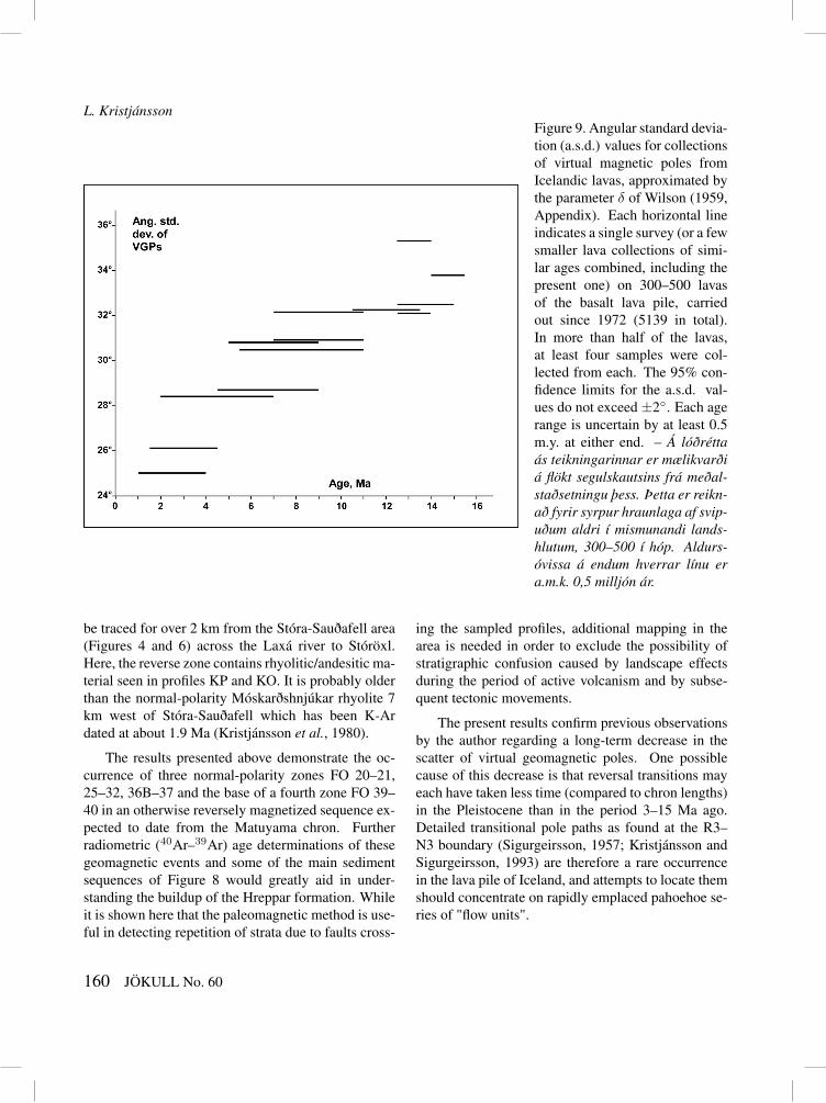
L. KristjánssonFigure 9. Angular standard devia-tion (a.s.d.) values for collectionsof virtual magnetic poles fromIcelandic lavas, approximated bythe parameter δ of Wilson (1959,Appendix). Each horizontal lineindicates a single survey (or a fewsmaller lava collections of simi-lar ages combined, including thepresent one) on 300–500 lavasof the basalt lava pile, carriedout since 1972 (5139 in total).In more than half of the lavas,at least four samples were col-lected from each. The 95% con-fidence limits for the a.s.d. val-ues do not exceed ±2◦. Each agerange is uncertain by at least 0.5m.y. at either end. – Á lóðréttaás teikningarinnar er mælikvarðiá flökt segulskautsins frá meðal-staðsetningu þess. Þetta er reikn-að fyrir syrpur hraunlaga af svip-uðum aldri í mismunandi lands-hlutum, 300–500 í hóp. Aldurs-óvissa á endum hverrar línu era.m.k. 0,5 milljón ár.
be traced for over 2 km from the Stóra-Sauðafell area(Figures 4 and 6) across the Laxá river to Stóröxl.Here, the reverse zone contains rhyolitic/andesitic ma-terial seen in profiles KP and KO. It is probably olderthan the normal-polarity Móskarðshnjúkar rhyolite 7km west of Stóra-Sauðafell which has been K-Ardated at about 1.9 Ma (Kristjánsson et al., 1980).
The results presented above demonstrate the oc-currence of three normal-polarity zones FO 20–21,25–32, 36B–37 and the base of a fourth zone FO 39–40 in an otherwise reversely magnetized sequence ex-pected to date from the Matuyama chron. Furtherradiometric (40Ar–39Ar) age determinations of thesegeomagnetic events and some of the main sedimentsequences of Figure 8 would greatly aid in under-standing the buildup of the Hreppar formation. Whileit is shown here that the paleomagnetic method is use-ful in detecting repetition of strata due to faults cross-
ing the sampled profiles, additional mapping in thearea is needed in order to exclude the possibility ofstratigraphic confusion caused by landscape effectsduring the period of active volcanism and by subse-quent tectonic movements.
The present results confirm previous observationsby the author regarding a long-term decrease in thescatter of virtual geomagnetic poles. One possiblecause of this decrease is that reversal transitions mayeach have taken less time (compared to chron lengths)in the Pleistocene than in the period 3–15 Ma ago.Detailed transitional pole paths as found at the R3–N3 boundary (Sigurgeirsson, 1957; Kristjánsson andSigurgeirsson, 1993) are therefore a rare occurrencein the lava pile of Iceland, and attempts to locate themshould concentrate on rapidly emplaced pahoehoe se-ries of "flow units".
160 JÖKULL No. 60

Paleomagnetic observations in SW- and S-Iceland
AcknowledgementsÁgúst Guðmundsson, Áslaug Geirsdóttir and ThorThordarson mapped the profiles of Figure 8 and pro-vided stratigraphic information on these. Rósa Ólafs-dóttir drafted the diagrams. Thorough reviews byMorten S. Riishuus and Bryndís Brandsdóttir im-proved the manuscript.
Bergsegulmælingar á hraunum frá Pleistósen-tímabili á þrem svæðum suðvestan- og sunnan-landsEftir að rannsóknir J. Hospers á segulstefnum í bergihér höfðu vakið athygli, hóf Trausti Einarsson um1953 að kanna legu jarðmyndana víða um land meðhjálp áttavitamælinga á sýnum úr hraunlögum. Helstarit hans um þau mál (Einarsson, 1962) fjallar að mestuleyti um myndanir frá Pleistósen-tímabili. Frekarirannsóknir á segulstefnu í Pleistósen hraunlögum hafaverið gerðar síðar á nokkrum afmörkuðum svæðum,en víða á landinu hefur athugunum Trausta ekki ver-ið haldið áfram. Í þessari grein er sagt frá sýnasöfn-un í jarðlagasniðum á þrem stöðum og bergsegulmæl-ingum á þeim sýnum í rannsóknastofu. Sniðin eru íÞórisgili í Brynjudal og Botnssúlum þar upp af, viðKjósarskarð beggja vegna Laxár, og við bæinn Foss-nes í Gnúpverjahreppi. Safnað var úr um 100 hraun-lögum alls, og reyndust þau vera góður efniviður tilmælinganna. Í fyrstnefnda sniðinu var staðfest nið-urstaða Trausta Einarssonar (1962) og Wilson o.fl.(1972) um að í Botnssúlum leggist syrpa með „rétta“segulstefnu ofan á aðra þykka með „öfuga“ segul-stefnu sem Trausti nefndi R2. Í sniðunum í Kjósar-skarði kemur fyrir samskonar umsnúningur jarðseg-ulsviðsins sem er mögulegt að fylgja a.m.k. tveggjakílómetra leið. Gæti það ásamt tilvist ísúrs og súrsbergs í sniðunum verið mjög gagnlegt fyrir frekarikortlagningu á því svæði. Við Fossnes koma þrjárþunnar syrpur rétt segulmagnaðra hraunlaga fyrir innií um 500 m þykku sniði af seti og hraunum sem aðmestu eru öfugt segulmögnuð. Upphleðsla staflansá öllum stöðunum virðist hafa verið nokkuð rykkj-ótt. Niðurstöður varðandi flökt jarðsegulsviðsins (útfrá meðalstefnu þess) á þessum tíma eru í samræmivið fyrri ályktanir höfundar um að þetta flökt hafi far-ið minnkandi sl. 15 milljón ár.
REFERENCESDoell, R. R. 1972. Palaeomagnetic studies of Icelandic
lava flows. Geophys. J. Royal Astron. Soc. 26, 459–479.
Einarsson, T. 1957. Magneto-geological mapping in Ice-land with the use of a compass. Adv. Phys. 6, 232–239.
Einarsson, T. 1962. Upper Tertiary and Pleistocene Rocksin Iceland. Soc. Sci. Isl. Rit 36, 197 pp. + maps.
Einarsson, T. and Þ. Sigurgeirsson 1955. Rock magnetismin Iceland. Nature 175, 892.
Eiríksson, J., A. I. Gudmundsson, L. Kristjánsson andK. Gunnarsson 1990. Palaeomagnetism of Pliocene-Pleistocene sediments and lava flows on Tjörnes andFlatey, North Iceland. Boreas 19, 39–55.
Friðleifsson, I. B., G. I. Haraldsson, L. S. Georgsson,E. Gunnlaugsson and B. J. Björnsson 1980. Jarðhitií Gnúpverjahreppi (Geothermal occurrences in theGnúpverjahreppur district). National Energy Author-ity Report OS80010/JHD06, 47 pp.
Geirsdóttir, Á., Þ. Þórðarson and L. Kristjánsson 1993.The interactive impact of climate deterioration andvolcanic activity on facies assemblages in latePliocene to early Pleistocene strata of the Hreppar For-mation, South Central Iceland (abstract). Eos Trans.AGU 74 (43, Suppl.), 131.
Geirsdóttir, Á., Þ. Þórðarson and L. Kristjánsson 1994. Á-hrif eldvirkni og loftslagsbreytinga á upphleðslu jarð-laga í Gnúpverjahreppi (Effect of volcanism and clim-ate changes on the emplacement of strata in the Gnúp-verjahreppur district). Geosci. Soc. Iceland, Springmeeting abstracts p. 6.
Helgason, J. and R. A. Duncan 2001. Glacial-interglacialhistory of the Skaftafell region, southeast Iceland. Ge-ology 29, 179–182.
Hospers, J. 1953. Reversals of the main geomagnetic field,I-II. Proc. Kon. Nederl. Akad. Wet. B56, 467–491.
Khodayar, M. and H. Franzson 2004. Stratigraphy and tec-tonics of eastern Núpur/western Hagafjall in Gnúp-verjahreppur, South Iceland. Iceland Geosurvey Re-port ISOR-2004/017, 42 p.
Khodayar, M. and H. Franzson 2007. Fracture pattern ofThjórsárdalur central volcano with respect to rift-jumpand a migrating transform zone in South Iceland. J.Struct. Geol. 29, 898–912.
Kristjánsson, L. 2008. Paleomagnetic research on Ice-landic lava flows. Jökull 58, 101–116.
JÖKULL No. 60 161
L. Kristjánsson
Kristjánsson, L. 2009. A new study of paleomagnetic di-rections in the Miocene lava pile between Arnarfjörðurand Breiðafjörður in the Vestfirðir peninsula, north-west Iceland. Jökull 59, 33–50.
Kristjánsson, L. and G. Jónsson 2007. Paleomagnetismand magnetic anomalies in Iceland. J. Geodyn. 43, 30–54.
Kristjánsson, L. and M. Sigurgeirsson 1993. The R3–N3and R5–N5 paleomagnetic transition zones in SW-Iceland revisited. J. Geomag. Geol. 45, 275–288.
Kristjánsson, L., I. B. Fridleifsson and N. D. Watkins1980. Stratigraphy and paleomagnetism of the Esja,Eyrarfjall and Akrafjall mountains, SW-Iceland. J.Geophys. 47, 31–42.
Kristjánsson, L., H. Jóhannesson, J. Eiríksson and A. I.Gudmundsson 1988. Brunhes-Matuyama paleomag-netism in three lava sections in Iceland. Can. J. EarthSci. 25, 215–225.
Kristjánsson, L., R. A. Duncan and Á. Gudmundsson1998. Stratigraphy, paleomagnetism and age of vol-canics in the upper regions of the Thjorsardalur valley,central southern Iceland. Boreas 27, 1–13.
Ogg, J. G. and A. G. Smith 2004. The geomagnetic polar-ity time scale. In: F. M. Gradstein, J. G. Ogg and A. G.Smith, eds. A Geologic Time Scale 2004. CambridgeUniv. Press, Cambridge, 63–86.
Pjetursson, H. 1905. Om Islands Geologi. Medd. DanskGeol. Forening 11, 106 pp.
Sigurgeirsson, Þ. 1957. Direction of magnetization in Ice-landic basalts. Adv. Phys. 6, 240–246.
Sæmundsson, K., H. Jóhannesson, Á. Hjartarson, S. G.Kristinsson and M. Á. Sigurgeirsson 2010. GeologicalMap of Southwest Iceland, 1:100.000. Iceland Geo-Survey, Reykjavík.
Udagawa, S., H. Kitagawa, A. Gudmundsson, O. Hiroi, T.Koyaguchi, H. Tanaka, L. Kristjánsson and M. Kono1999. Age and magnetism of lavas in the Jökuldalurarea, Eastern Iceland: Gilsá event revisited. Phys.Earth Planet. Inter. 115, 147–171.
Watkins, N. D., L. Kristjánsson and I. McDougall 1975. Adetailed survey of the type location for the Gilsá geo-magnetic polarity event. Earth Planet. Sci. Lett. 27,436–444.
Wilson, R. L. 1959. Remanent magnetism of Late Sec-ondary and Early Tertiary British rocks. Phil. Mag. 4,750–755.
Wilson, R. L., N. D. Watkins, T. Einarsson, T. Sig-urgeirsson, S. E. Haggerty, P. J. Smith, P. Dagley andA. McCormack 1972. Palaeomagnetism of ten lavasequences from south-western Iceland. Geophys. J.Royal Astron. Soc. 29, 459–471.
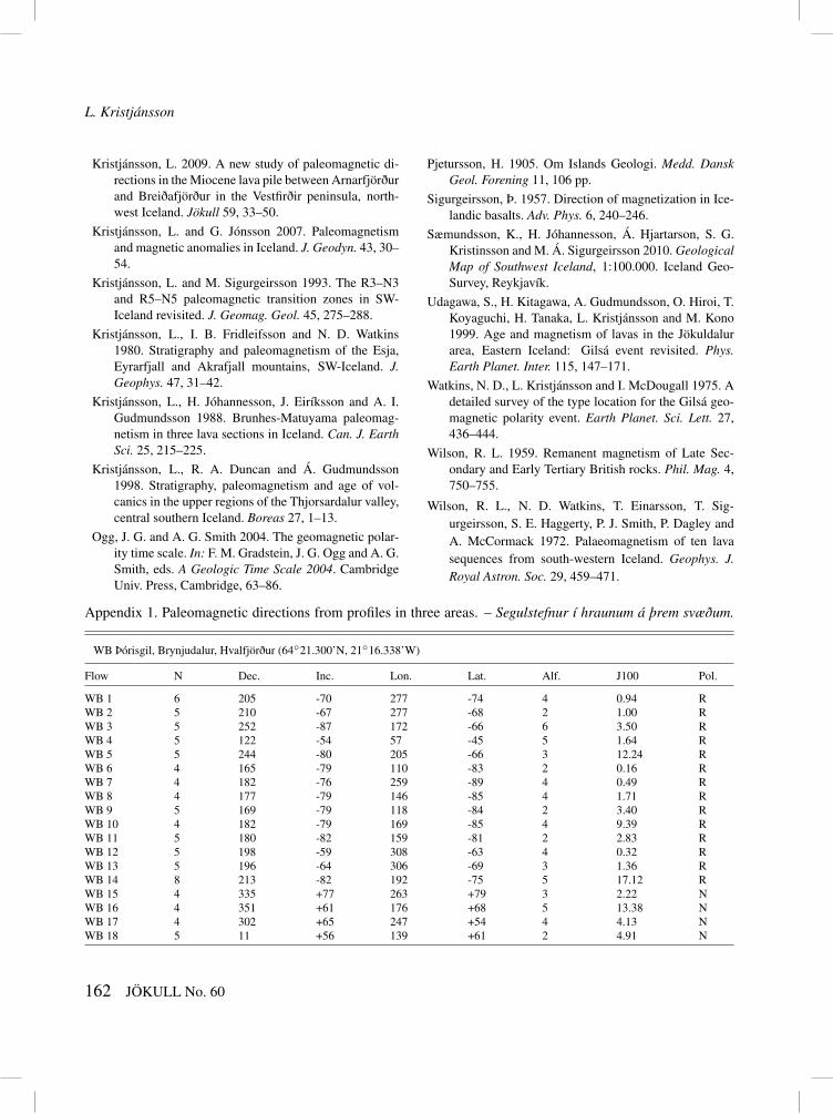
Appendix 1. Paleomagnetic directions from profiles in three areas. – Segulstefnur í hraunum á þrem svæðum.
WB Þórisgil, Brynjudalur, Hvalfjörður (64◦21.300’N, 21◦16.338’W)
Flow N Dec. Inc. Lon. Lat. Alf. J100 Pol.
WB 1 6 205 -70 277 -74 4 0.94 RWB 2 5 210 -67 277 -68 2 1.00 RWB 3 5 252 -87 172 -66 6 3.50 RWB 4 5 122 -54 57 -45 5 1.64 RWB 5 5 244 -80 205 -66 3 12.24 RWB 6 4 165 -79 110 -83 2 0.16 RWB 7 4 182 -76 259 -89 4 0.49 RWB 8 4 177 -79 146 -85 4 1.71 RWB 9 5 169 -79 118 -84 2 3.40 RWB 10 4 182 -79 169 -85 4 9.39 RWB 11 5 180 -82 159 -81 2 2.83 RWB 12 5 198 -59 308 -63 4 0.32 RWB 13 5 196 -64 306 -69 3 1.36 RWB 14 8 213 -82 192 -75 5 17.12 RWB 15 4 335 +77 263 +79 3 2.22 NWB 16 4 351 +61 176 +68 5 13.38 NWB 17 4 302 +65 247 +54 4 4.13 NWB 18 5 11 +56 139 +61 2 4.91 N
162 JÖKULL No. 60

Paleomagnetic observations in SW- and S-Iceland
Appendix 1. cont.
KJ Stóra-Sauðafell, Kjósarskarð (64◦15.002’N, 21◦22.684’W)
KJ 1 4 149 -53 25 -54 5 1.13 RKJ 2 4 176 -72 357 -83 3 0.70 RKJ 3 4 185 -71 320 -81 4 3.67 RKJ 4 4 198 -60 305 -65 2 1.79 RKJ 5 4 213 -74 247 -74 2 2.61 RKJ 6 4 179 -72 343 -87 2 17.44 RKJ 7 5 185 -71 320 -80 2 5.97 RKJ 8 5 188 -73 303 -82 1 8.79 RKJ 9 5 196 -73 275 -81 5 5.63 RKJ 10 7 191 -49 322 -55 5 0.96 RKJ 10A 5 39 +68 83 +66 3 3.37 NKJ 11 4 43 +69 75 +65 4 2.34 NKJ 12 4 29 +70 92 +72 3 2.49 NKJ 13 4 40 +70 77 +67 3 1.51 NKJ 14 5 22 +55 113 +70 3 2.30 NKJ 15 5 35 +68 89 +67 2 9.46 NKJ 16 6 353 +66 175 +74 4 2.81 N
KI Stóra-Sauðafell, Kjósarskarð (supplementary profile)
KI 1 5 195 -51 315 -56 4 1.96 RKI 2 4 143 -46 30 -46 2 4.14 RKI 3 4 186 -72 312 -82 3 0.77 RKI 4 4 189 -60 322 -66 7 0.33 RKI 5 5 199 -58 306 -62 2 1.48 RKI 6 4 175 -68 353 -76 3 6.32 R
KK North end of Stóra-Sauðafell, Kjósarskarð
KK 1 6 191 -61 316 -67 3 2.06 RKK 2 4 200 -58 305 -61 3 2.14 R
KP Hrútagil, west of Kjósarskarð (64◦15.083’N, 21◦24.108’W)
KP 2 3 173 -72 7 -81 3 2.54 RKP 3 6 169 -60 359 -66 2 3.03 RKP 4 6 186 -62 327 -69 2 4.25 RKP 5 4 190 -59 321 -65 4 1.92 RKP 6 5 222 -70 255 -67 2 0.99 RKP 7 4 245 -77 215 -64 6 3.87 RKP 8 5 152 -53 21 -55 2 1.39 RKP 8A 4 224 -78 220 -72 1 5.13 RKP 9 5 243 -75 226 -62 2 2.45 RKP 10 5 208 -73 256 -76 2 4.26 RKP 11 4 209 -73 259 -75 3 3.16 RKP 12 4 202 -64 283 -74 4 1.67 RKP 13 4 208 -71 268 -73 3 2.54 RKP 14 6 52 +69 67 +61 4 1.02 N
KN Stóröxl, Kjósarskarð (64◦15.47’N 21◦21.55’W)
KN 1 4 210 -78 222 -78 2 2.90 RKN 2 4 199 -76 244 -81 2 5.81 RKN 3 5 200 -74 260 -80 2 4.18 RKN 4 4 196 -73 275 -81 5 4.76 RKN 5 5 49 +67 75 +60 4 5.60 NKN 6 5 47 +62 85 +56 7 4.86 N
JÖKULL No. 60 163

L. Kristjánsson
Appendix 1. cont.
KO Stóröxl, Kjósarskarð (64◦15.60’N, 21◦22.09’W)
KO 1 4 235 -72 237 -64 2 1.72 RKO 2 6 144 -79 100 -75 4 5.93 RKO 2B 4 184 -61 331 -67 6 2.77 RKO 3 4 196 -69 296 -75 4 0.53 R
HR/FO Þverá-Fossnes, Þjórsárdalur (64◦03.821’N, 20◦06.334’W)Lavas in approx. stratigraphic order. See text for probable duplications
HR 5A 4 281 -87 174 -62 5 4.6 RHR 5B 4 227 -71 250 -65 3 13.7 RHR 5D 4 195 -80 200 -82 4 2.2 RHR 5F 4 206 -75 247 -78 4 3.2 RHR 5H 4 225 -87 172 -68 2 0.3 RHR 5I 4 139 -62 48 -59 3 7.6 RHR 5L 4 260 -78 208 -59 3 3.3 RHR 5N 4 83 -88 151 -63 2 2.3 RHR 5P 4 29 -86 154 -58 4 5.8 RHR 5S 4 114 -86 141 -66 6 1.7 RFO 20 5 339 +68 210 +72 4 11.5 NHR 5V 4 348 +59 182 +64 4 9.0 NFO 21 7 342 +60 192 +65 3 8.0 NHR 7A 5 189 -84 168 -76 2 2.8 RFO 22 4 186 -55 330 -61 9 2.3 RFO 23 4 173 -61 354 -67 7 0.8 RFO 24 4 353 -16 167 +18 7 0.7 NTFO 25 4 79 +82 15 +63 12 2.3 NFO 26 4 29 +80 26 +77 3 1.6 NFO 27 4 16 +77 56 +83 4 1.6 NFO 28 4 40 +79 39 +73 4 3.2 NHR 9A 4 40 +85 2 +71 5 2.3 NFO 29 4 24 +73 86 +77 2 1.8 NHR 9B 5 30 +78 41 +77 6 2.6 NFO 30 4 65 +76 41 +63 4 3.7 NHR 9C 4 37 +76 56 +74 4 9.5 NFO 31 4 57 +75 50 +64 3 3.2 NFO 32 5 45 +74 61 +69 7 4.2 NHR 9E 4 60 +79 32 +66 5 4.9 NFO 33 4 105 -72 94 -54 12 1.3 RFO 35 4 99 -73 100 -54 6 1.9 RHR 9D 4 124 -70 77 -61 3 2.1 RFO 34 4 50 +74 55 +67 2 1.3 NFO 36A 4 10 -86 158 -57 5 1.4 RFO 36B 3 17 +53 133 +58 2 0.7 NFO 37 4 13 +60 136 +65 4 3.6 NFO 38 4 193 -73 281 -82 4 2.2 RHR 11A,B 4 81 -82 131 -58 5 0.6 RFO 39 4 48 +74 58 +68 3 3.3 NFO 40 4 29 +61 109 +63 9 1.9 N
N = number of samples averaged. Dec, inc = declination and inclination of each remanence direction. Lon, lat = coordinates of thecorresponding virtual geomagnetic pole (VGP). Alf = 95% confidence angle for the mean direction, in degrees. J100 = mean remanenceintensity after 10 mT (100 Oe) alternating field treatment, in A/m. Pol = polarity, with N = normal, R = reverse, T = low-latitude VGP. Thecoordinates given are those at the lowest lava flow. The tectonic tilt corrections applied may be uncertain by up to 2◦. – N = fjöldi sýna.Dec, inc = misvísun og halli segulstefnu. Lon, lat = lengd og breidd sýndar-segulskauts. Alf = óvissa í segulstefnunni. J100 = styrkursegulmögnunar. Pol segir til um hvort segulstefnan er „rétt“ (N) eða „öfug“ (R). Staðsetning neðsta hraunlags er gefin.
164 JÖKULL No. 60