Embed Size (px)
Citation preview

Earth Planets Space, 52, 467–478, 2000
Paleomagnetic data from the Trans-Mexican Volcanic Belt: implicationsfor tectonics and volcanic stratigraphy
Luis M. Alva-Valdivia1, Avto Goguitchaichvili1, Luca Ferrari2, Jose Rosas-Elguera3,
Jaime Urrutia-Fucugauchi1, and Jose J. Zamorano-Orozco4
1Instituto de Geofısica, Universidad Nacional Autonoma de Mexico, Laboratorio de
Paleomagnetismo y Geofısica Nuclear, Ciudad Universitaria, 04510 Mexico D.F., Mexico2 Instituto de Geologıa, Universidad Nacional Autonoma de Mexico, Apdo.
Postal 70-296, Ciudad Universitaria, 04510 Mexico D.F., Mexico3 Centro de Ciencias de la Tierra, Universidad de Guadalajara, Calzada Olımpica
y Blvd. Marcelino Garcia Barragan, 44840 Guadalajara, Jalisco, Mexico4 Instituto de Geografıa, Universidad Nacional Autonoma de Mexico, Ciudad Universitaria, 04510 Mexico D.F., Mexico
(Received November 15, 1999; Revised June 5, 2000; Accepted June 9, 2000)
We report a paleomagnetic and rock-magnetic study of Miocene volcanic rocks from the Trans-Mexican VolcanicBelt. A total of 32 sites (238 oriented samples) were collected from three localities: Queretaro, Guadalajara andLos Altos de Jalisco basaltic plateaux, which span from 11 to 7.5 Ma. Several rock-magnetic experiments werecarried out in order to identify the magnetic carriers and to obtain information about their paleomagnetic stability.Microscopic observation of polished sections shows that the main magnetic mineral is Ti-poor titanomagnetiteassociated with exsolved ilmenite. Continuous susceptibility measurements with temperature yield in most casesreasonably reversible curves with Curie points close to that of magnetite. Judging from the ratios of hysteresisparameters, it seems that all samples fall in the pseudo-single domain (PSD) grain size region, probably indicating amixture of multidomain (MD) and a significant amount of single domain (SD) grains. Based on our paleomagneticand available radiometric data, it seems that the volcanic units have been emplaced during a relatively short time spanof 1 to 2 My at each locality. The mean paleomagnetic directions obtained from each locality differ significantlyfrom that expected for the Middle Miocene. The mean paleomagnetic direction calculated from 28 sites discardingthose of intermediate polarity is I = 32.46◦, D = 341.2◦, k = 7.2 and α95 = 11.6◦. Comparison with the expecteddirection indicates some 20◦ anticlockwise tectonic rotations for the studied area, in accordance with the proposedleft-lateral transtensional tectonic regime already proposed for this period.
1. IntroductionThe Trans-Mexican Volcanic Belt (TMVB), one of the
largest continental volcanic arcs built on the North Americaplate, spans about 1000 km and crosses central Mexico fromthe Pacific to the Atlantic coast (Fig. 1). Subduction-relatedvolcanism in Mexico resumed in the Eocene after Laramidedeformation and formed the Sierra Madre Occidental silicicvolcanic province (Fig. 1). During early to middle Miocenetime, the volcanic arc rotated counterclockwise and, in thelate Miocene, began to form the TMVB as a result of subduc-tion of the Cocos and Rivera plates (Ferrari et al., 1999). Theinitial stage of the TMVB is marked by widespread basalticvolcanism, emplaced from the Pacific coast to the longi-tude of Mexico City, to the north of the modern volcanicarc (Fig. 1). This volcanism is characterized by plateau-likestructures resulting from the coalescence of shield volcanoesand fissure lava flows, which have an estimated aggregatevolume ranging between 3200 and 6800 km3 (Ferrari et al.,2000). Geologic and stratigraphic studies have shown that
Copy right c© The Society of Geomagnetism and Earth, Planetary and Space Sciences(SGEPSS); The Seismological Society of Japan; The Volcanological Society of Japan;The Geodetic Society of Japan; The Japanese Society for Planetary Sciences.
these basaltic lavas were emplaced in a period between about11 and 8 Ma (Ferrari et al., 1994a and 2000; Moore et al.,1994; Righter et al., 1995), which is also concurrent with theinitial opening of the Gulf of California.
Several authors have suggested that during this period theTMVB, to the west of Guadalajara, experienced left-lateraltranstensional tectonic deformation (Pasquare et al., 1988;Garduno et al., 1993; Ferrari et al., 1994b and 2000; Urrutia-Fugugauchi and Rosas-Elguera, 1994). However, due to thepoor behavior of basaltic rock for recording slickensides onfault planes, left-lateral oblique faulting has been directlyobserved at only a few sites. On the other hand, their well-established stratigraphic position and the easy access of thesebasalts makes them a good target for paleomagnetic studies,with the purpose of determining to what extent this succes-sion has been affected by tectonic rotation about a verticalaxis. In this paper we present the results of a regional paleo-magnetic study of the basaltic sequences, which also providesbetter constraints on the age of the rocks.
2. Geologic Setting and SamplingWe carried out systematic sampling at sites located in up-
per Miocene basaltic lava flows in four areas in the states of
467

468 L. M. ALVA-VALDIVIA et al.: PALEOMAGNETISM FROM CENTRAL MEXICO
Fig. 1. Plate tectonic setting of central Mexico, showing the Cenozoic volcanic provinces and outcrops of upper Miocene mafic lavas. G = Guadalajara,MC = Mexico City.
Jalisco, Guanajuato, Queretaro, and Hidalgo (Figs. 1, 2, 3,4). We focussed on sites where an isotopic age was available(Table 3) or that might be unambiguously correlated withdated sites.
The largest exposure of the upper Miocene basalts is alongtheRioGrandedeSantiagorivercanyon, northof Guadalajara(Figs. 2 and 3) where it has been informally named the SanCristobal basalt by Moore et al. (1994). The exposed vol-canic succession is over 700 m thick and filled a pre-existingdepression cut into lower Miocene ash-flow tuffs belongingto the Sierra Madre Occidental silicic volcanic province. Wesampled this succession along two transects running alongboth riverbanks. The first one crosses the succession in anorth-south direction at about 35 km north of Guadalajara(Fig. 2). Site BGC is located in an eroded basaltic shieldvolcano, dated at 11 Ma (Moore et al., 1994), and repre-sents the oldest rock of the succession. Two sites located tothe south (AM) were later dated as early Miocene (Ferrari,unpublished data) and were therefore discarded from our pa-leomagnetic analysis. The rest of the sites (BM, and SCBseries) are located at different elevations in the river canyon;where the succession was dated ca. 10 Ma (Damon et al.,1979; Moore et al., 1994; figure 2). The second transect islocated immediately east of Guadalajara, about 20 km southof the site of a previous paleomagnetic and geochronologicstudy by Watkins et al. (1971). Rocks sampled are not datedat this location but can be correlated with those dated by theseauthors between 9.5 and 9.0 Ma (Table 3).
East of Guadalajara, in the Los Altos de Jalisco region,the basalts exposed in the Rio Grande de Santiago river forma 130 km long, 60 km wide plateau, with a mean elevationof 1900 m. In the Rio Verde valley, 25 km northwest ofTepatitlan (Fig. 3) the basalts are about 220 m thick and areaffected by a left-lateral transtensional fault system runningfrom Ixtlahuacan to San Miguel el Alto in a ENE-WSW
direction (Ferrari et al., 2000, see also Fig. 3). The south-ern part of the Los Altos de Jalisco plateau is disrupted byan extensional fault system, which runs from Ocotlan toCueramaro (Fig. 3) and shows a left-lateral component ofmotion. In this area the basalts crop out in tilted blockspartly covered by younger volcanic rocks (Rosas-Elgueraand Urrutia-Fucugauchi, 1998). We sampled several blocksdisrupted by transtensional fault system (LC, LR, AC, CM,LP). Another three sites were sampled to the north, inside aless disturbed plateau (SJG, AR, CP) (Fig. 3). The availabledates indicate that at all these sites the basalts were emplacedbetween 10.2 ± 0.3 and 8.7 ± 1.0 Ma (Nieto-Obregon et al.,1981; Nixon et al., 1987; Rosas-Elguera et al.,1989; Rosas-Elguera and Urrutia-Fucugauchi, 1998).
East of Penjamo (Fig. 3), about 10 km north of Salamanca,upper Miocene basalts crop out as a tabular succession northof the Bajio fault (Nieto-Samaniego et al., 1999, figure 4).They range between 100 and 200 m in thickness, and overlielower Miocene ash flows and Oligocene rhyolitic lava domes(Fig. 4). Other outcrops of mafic lava flows emerge from thealluvial filling of the Bajio depression are found north ofCelaya (Fig. 4). The lavas of Salamanca and Celaya yielddates ranging between 9.5 and 10.5 Ma (Hasenaka et al.,1994; Cerca-Martınez, 1998), suggesting that they representfragments of a unique tabular volcanic structure. We sampledthe site dated as 10.2 ± 0.1 Ma by Hasenaka et al. (1994)(site TH), which represents one of the youngest lava flows inthe succession.
The most widespread outcrops of upper Miocene lavas arearound the city of Queretaro (Fig. 4), where several isolatedtabular volcanic structures likely represent remnants of an oldplateau-like structure at a mean elevation of 1950 m (Fig. 4).The lava flows cap a fluvio-lacustrine succession and exhibita total thickness of about 80 m. Site AE is located in one ofthe uppermost lava flows exposed near the Queretaro airport,

L. M. ALVA-VALDIVIA et al.: PALEOMAGNETISM FROM CENTRAL MEXICO 469
Fig. 2. Geologic map of the Rio Grande de Santiago and Guadalajara region with locations of sampling sites. Sites marked W1 to W4 are from Watkinset al. (1971).
having date of 8.1 ± 0.8 Ma (Pasquare et al., 1991). Site VCwas in a basaltic andesite from the bottom of the succession,with an age of 9.6 ± 1.0 Ma (Murillo-Muneton and Torres-Vargas, 1987). The other sites in the Queretaro area are inlava flows inferred to be bracketed between these dates (CA,LSE, LNE), except site CI, located in the Cerro Cimatarioshield volcano, that caps the tabular basaltic succession andcould be younger than the flows sampled at the Queretaroairport.
The easternmost exposure of upper Miocene basalts isin the state of Hidalgo around the Pathe geothermal area,∼50 km east of Queretaro City (Fig. 4). The Pathe successionis defined by 80 to 300 m of sub-horizontal lava flows, in-
terbedded with several spatter and scoria cones, which partlyfed the basaltic succession. One of the uppermost lava flowswas dated by Suter et al. (1995) at 7.7 ± 0.1 Ma, using40Ar/39Ar systematics. We sampled two flows at the baseof the succession in the northwestern part of the lava field,which were dated by Jacobo-Albarran (1986) at 9.3±0.5 Ma(Fig. 4).
In total, 238 oriented samples belonging to 32 flows werecollected. Commonly, the outcrops extend laterally over afew tens of meters and in these cases we drilled typically8–10 cores per flow. The samples were distributed through-out each flow both horizontally and vertically in order tominimize effects of block tilting and lightning. In general,
470 L. M. ALVA-VALDIVIA et al.: PALEOMAGNETISM FROM CENTRAL MEXICO
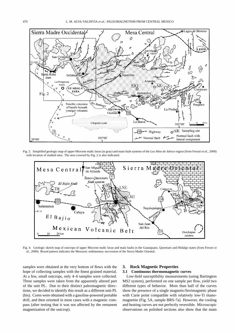
Fig. 3. Simplified geologic map of upper Miocene mafic lavas (in gray) and main fault systems of the Los Altos de Jalisco region (from Ferrari et al., 2000)with location of studied sites. The area covered by Fig. 2 is also indicated.
Fig. 4. Geologic sketch map of outcrops of upper Miocene mafic lavas and main faults in the Guanajuato, Queretaro and Hidalgo states (from Ferrari etal., 2000). Boxed pattern indicates the Mesozoic sedimentary succession of the Sierra Madre Oriental.
samples were obtained at the very bottom of flows with thehope of collecting samples with the finest grained material.At a few, small outcrops, only 4–6 samples were collected.Three samples were taken from the apparently altered partof the unit PL. Due to their distinct paleomagnetic direc-tions, we decided to identify this result as a different unit PL(bis). Cores were obtained with a gasoline-powered portabledrill, and then oriented in most cases with a magnetic com-pass (after testing that it was not affected by the remanentmagnetization of the outcrop).
3. Rock Magnetic Properties3.1 Continuous thermomagnetic curves
Low-field susceptibility measurements (using BartingtonMS2 system), performed on one sample per flow, yield twodifferent types of behavior. More than half of the curvesshow the presence of a single magnetic/ferrimagnetic phasewith Curie point compatible with relatively low-Ti titano-magnetite (Fig. 5A, sample BRS-7a). However, the coolingand heating curves are not perfectly reversible. Microscopicobservations on polished sections also show that the main

L. M. ALVA-VALDIVIA et al.: PALEOMAGNETISM FROM CENTRAL MEXICO 471
Fig. 5. A) Susceptibility versus temperature (in air) curves of representative samples. The arrows indicate the heating and cooling curves. B) Typicalexamples of hysteresis loops (uncorrected) of small chip samples from the studied volcanic flows.
magnetic mineral is low-Ti titanomagnetite associated withexsolved ilmenite, probably formed as a result of oxidationof titanomagnetite during initial cooling. These intergrowthstypically develop higher than 600◦C (Haggerty, 1976) andconsequently, the NRM (natural remanent magnetization)carried by these samples should be a thermoremanent (TRM)magnetization.
In other cases, mainly flows from the Los Altos region,yield two different thermomagnetic phases during heating(Fig. 5A, sample AC-8a). The lower Curie point rangesbetween 380–420◦C, and the highest one is about 580◦C.The cooling curve shows only a single phase, with a Curietemperature close to that of magnetite. Such irreversiblecurves can be explained by titanomaghemite, which probablytransformed into magnetite (Readman and O’Reilly, 1972;Ozdemir, 1987) during heating. Both experimental and the-oretical studies (Heider and Dunlop, 1987; Nishitani andKono, 1989; Ozdemir and Dunlop, 1989; Goguitchaichvili etal., 2000) show that chemical remagnetization by maghemi-tization records have the same direction as the original TRM.Consequently, paleodirections were most probably un-affected by alteration.
3.2 Hysteresis experimentsHysteresis measurements were performed on samples from
all flows using an AGFM ‘Micromag’, in fields up to 1 T.Curves were rather symmetrical in all cases (Fig. 5B). Nearthe origin, no potbellied and wasp-waisted behavior (Tauxeet al., 1996) was detected, which probably reflects very re-stricted dual ranges of the opaque mineral coercivities. IRM(isothermal remanent magnetization) acquisition curves (notshown) were found very similar for all samples. Saturationis reached in moderate fields of the order of 100–150 mT,which reveals that a cubic phase is principal remanence car-rier. Based on the ratios of hysteresis parameters, all sam-ples fall in the pseudo-singledomain (PSD) grain size region,probably indicating a mixture of multidomain (MD) and asignificant amount of singledomain (SD) grains.
4. Paleomagnetism4.1 Methods
Remanence measurements were made using a Molspinspinner magnetometer (sensitivity ∼ 10−8Am2). Stepwisealternating field (AF) demagnetization used a home madeAF demagnetizer providing fields up to 200 mT. Stepwise
472 L. M. ALVA-VALDIVIA et al.: PALEOMAGNETISM FROM CENTRAL MEXICO
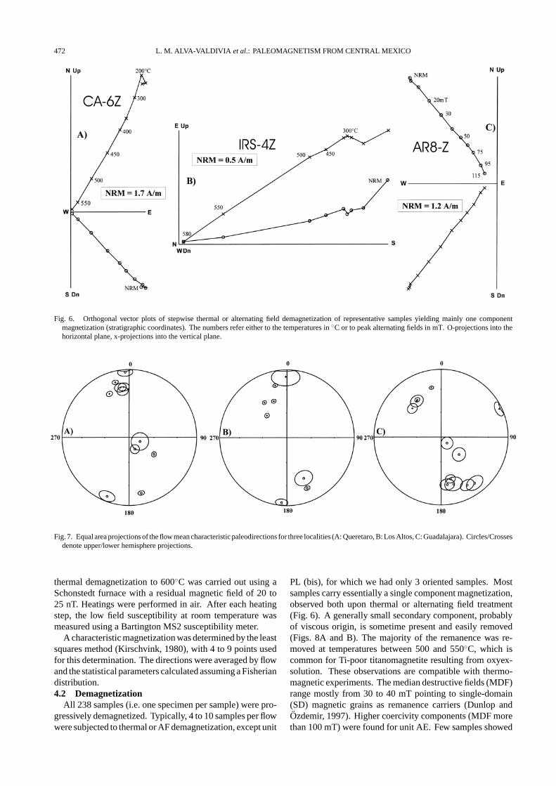
Fig. 6. Orthogonal vector plots of stepwise thermal or alternating field demagnetization of representative samples yielding mainly one componentmagnetization (stratigraphic coordinates). The numbers refer either to the temperatures in ◦C or to peak alternating fields in mT. O-projections into thehorizontal plane, x-projections into the vertical plane.
Fig. 7. Equal area projections of the flow mean characteristic paleodirections for three localities (A: Queretaro, B: Los Altos, C: Guadalajara). Circles/Crossesdenote upper/lower hemisphere projections.
thermal demagnetization to 600◦C was carried out using aSchonstedt furnace with a residual magnetic field of 20 to25 nT. Heatings were performed in air. After each heatingstep, the low field susceptibility at room temperature wasmeasured using a Bartington MS2 susceptibility meter.
A characteristic magnetization was determined by the leastsquares method (Kirschvink, 1980), with 4 to 9 points usedfor this determination. The directions were averaged by flowand the statistical parameters calculated assuming a Fisheriandistribution.4.2 Demagnetization
All 238 samples (i.e. one specimen per sample) were pro-gressively demagnetized. Typically, 4 to 10 samples per flowwere subjected to thermal or AF demagnetization, except unit
PL (bis), for which we had only 3 oriented samples. Mostsamples carry essentially a single component magnetization,observed both upon thermal or alternating field treatment(Fig. 6). A generally small secondary component, probablyof viscous origin, is sometime present and easily removed(Figs. 8A and B). The majority of the remanence was re-moved at temperatures between 500 and 550◦C, which iscommon for Ti-poor titanomagnetite resulting from oxyex-solution. These observations are compatible with thermo-magnetic experiments. The median destructive fields (MDF)range mostly from 30 to 40 mT pointing to single-domain(SD) magnetic grains as remanence carriers (Dunlop andOzdemir, 1997). Higher coercivity components (MDF morethan 100 mT) were found for unit AE. Few samples showed

L. M. ALVA-VALDIVIA et al.: PALEOMAGNETISM FROM CENTRAL MEXICO 473
Table 1. Unit mean directions of remanence and corresponding VGP positions for all flows. N , number of treated samples; n, number of specimens usedfor calculation; Dec, Declination; Inc, Inclination. k and α95: precision parameter and radius of 95% confidence cone of Fisher statistics, δ: angulardistance from the normal dipole direction. Pol, Magnetic polarity, Plat/Plong: Latitude/Longitude of VGP position.
Flow Location Lat Long n\N Dec Inc k α95 δ Pol Plat Plong
Queretaro
AE Queretaro airport 20◦37.130 100◦22.952 8\8 335.3 30.1 263.1 3.4 21.2 N 66.1 163.7
AV Sta. Rosa Jauregui, Qro 20◦43.708 100◦26.501 10\10 345.6 17.2 237.3 3.1 20.4 N 71.9 131.9
CA Queretaro toll house 20◦34.181 100◦29.005 10\10 124.4 −53.4 418.6 2.4 136.1 I −39.3 17.3
CI Cerro Cimatario, Qro. 20◦31.217 100◦19.932 6\8 200.9 −8.1 100.1 7.7 148.5 R −64 205.6
LNE Highway to S.M. Allende 20◦43.061 100◦21.714 8\8 349.8 26.3 87.4 6.1 11.1 N 78.3 137.5
LSE Highway to S.M. Allende 20◦40.857 100◦18.645 8\8 351.8 31.6 84.6 5.9 7.1 N 81.6 148.1
PL North of Pathe, Hgo. 20◦40.599 99◦41.965 5\5 356.4 −4 132.2 6.7 37.2 N 67.3 89.9
PL (bis) North of Pathe, Hgo. 20◦40.599 99◦41.965 3\3 110.8 −76.1 139.1 10.5 126.3 I −27.4 52.7
PT North of Pathe, Hgo. 20◦39.909 99◦41.920 8\8 167.7 −17.4 254 3.2 160.9 R −73.5 308.3
TH N of Juventino Rosas 20◦42.168 101◦02.584 8\8 353.6 26.1 94.7 5.7 8.9 N 80.9 122.4
VC Villa Corregidora 20◦39.965 100◦25.606 6\6 154.1 −74.3 155 5.4 136.8 R −46 62.3
Los Altos
AC Atotonilco, Jal. 20◦29.880 102◦27.450 8\8 157.8 −20.7 339.5 3 156.8 R −66.6 326.9
AR W of Arandas, Jal. 20◦42.130 102◦19.660 9\9 326.9 38.2 445.8 2.4 27.3 N 59.1 176.8
CM Ayotlan, Jal. 20◦33.060 102◦18.770 10\10 317.5 53.6 302.7 2.8 36.4 N 50.1 197.2
CP Cerro Pelon quarry 20◦40.530 102◦13.900 9\9 157.2 −35.2 32.2 9.9 161 R −68.6 349.3
LC Ocotlan toll house, Jal. 20◦24.100 102◦44.140 8\8 184.7 −4.7 99.4 5.6 151.4 R −71.5 243.6
LP Presa Huascato, Jal. 20◦29.310 102◦14.000 10\10 339.9 42.2 360.3 2.5 18.3 N 71 184.1
LR Atotonilco, Jal. 20◦31.410 102◦26.140 8\8 347.2 22.2 736.1 2.1 15.6 N 74.9 134.2
SJG N of Atotonilco 20◦41.200 102◦32.660 8\10 358.8 11.1 15.4 13.5 21.9 N 75.1 82.3
MB* Mesa del Burro 20◦40.500 103◦25.500 6\7 5 33.8 59.1 8.8 4.3 N 79.1 50.8
Guadalajara
AM2 El Malacate 21◦09.670 103◦25.740 7\7 167.4 −36.8 122.1 5.5 169 R −78.2 342.3
AM1 El Malacate 21◦09.330 103◦26.110 6\8 164.9 −28.9 66.9 9.4 166.4 R −74.3 325
BGCS1 Cerro Mata, Zac. 21◦11.160 103◦27.280 4\4 135.6 −79.8 165.8 7.2 129.9 I −34.4 60.1
BGCS2 Cerro Mata, Zac. 21◦11.160 103◦27.280 5\5 151.1 −20.1 110.2 7.3 151.2 R −60.1 330
BIRS Rio Santiago canyon 20◦40.420 103◦11.370 4\4 325.8 35.8 157.4 7.3 28.2 N 58.1 171.9
BM N of San Cristobal 21◦07.890 103◦25.180 5\6 133.9 −59.5 90.1 8.1 139.9 R −46.4 24.1
BRS Road to Ixtlahuaca 20◦40.550 103◦10.230 8\8 348.7 26.6 586.6 2.3 11.7 N 77.5 138.2
BRS1 Road to Ixtlahuaca 20◦40.040 103◦10.830 6\6 143.4 −16.4 55.4 9.1 143.1 R −53.6 306.4
IRS Road to Ixtlahuaca 20◦40.300 103◦11.160 4\5 172.6 −29.9 144.4 7.7 173 R −81.7 316.3
ISG San Gaspar 20◦41.500 103◦10.530 8\10 64.3 4.2 83.6 6.6 66.3 I 24.8 354.3
SCB1 San Cristobal 21◦02.540 103◦25.540 9\9 327.1 34.8 336.2 2.8 27.3 N 59.1 170.4
SCB2 San Cristobal 21◦03.400 103◦25.640 6\6 314.7 39.7 188.7 5.9 36.7 N 47.9 178.3
*Site MB represent very young (most probably late Bruhnes) lava flow and yielded paleodirections close to the present day field.
more complex or ‘unstable’ remanence and no primary mag-netization was determined.4.3 Directions of characteristic remanent magnetiza-
tionThe flow mean paleodirections are overall well-determined
(Table 1, Fig. 7). Almost all α95 values are less than 10◦, ex-cept the unit PL (bis) where we had only 3 samples and SJG,which seems to be affected by lightning.
Six normal, three reverse and two intermediate polarityflows were recognized for Queretaro volcanic field (Table 1).Their correlation with geomagnetic polarity time scale(GPTS) is discussed below. In this paper, we formally usethe paleolatitude of 45◦ as a cut-off angle to separate thepaleosecular variation and intermediate geomagnetic regime(McElhinny and McFadden, 1997). In absence of more de-tailed paleomagnetic coverage, we are not sure that the in-

474 L. M. ALVA-VALDIVIA et al.: PALEOMAGNETISM FROM CENTRAL MEXICO
Fig. 8. Equal area projection of the mean directions for all flows and for the three groups of sites as indicated in Table 3.
Table 2. Between flow average directions and VGPs for the Queretaro, Los Altos and Guadalajara sites. S is the total between flow dispersion of averageflow VGP. Su and Sl are 95 per cent confidence limits for S after Cox (1969). Intermediate directions (flows: CA, PL (bis) and BGCS1) are discarded(see text). In addition, four units (AM1, AM2, MB and ISG) were also discarded for the analyses because their inadequate ages (see text and Table 3).
Locality N Inc Dec k α95 Plat Plong K α95 S Sl Su
Queretaro 9 33.7 350.8 3 33.2 80.6 140 14 14.2 21.7 16.6 31.2
Los Altos 8 29.2 343.5 15 14.8 72.5 159 20 12.6 18.1 13.7 26.8
Guadalajara 8 33.5 330.7 21 12.4 63.4 164 18 13.5 19.2 14.5 28.4
All 25 32.4 341.2 7 11.6 72.7 158 16 7.5 20.3 17 25.2
termediate VGP’s found in this study have a geomagneticsignificance. Los Altos region yielded mostly normal polar-ity magnetization except flows AC, CP and LC, which arereversely magnetized. Six reversed, four normal and twointermediate polarity flows were recognized in Guadalajaravolcanic field (Fig. 7 and Table 1)
5. Discussion and ConclusionsIn general the polarity obtained for the flows studied is
consistent with their stratigraphic position and with absoluteage determinations for each site (Fig. 9). Combining theavailable geochronologic data with the polarity of the pale-omagnetic samples obtained in this study, better constraintsof the age of emplacement can be achieved (Table 3, Fig. 9).
Lava flows sampled in the northern transect of the RioGrande de Santiago (BGC, BM and SCB series) may all beput into Anomaly 5. The older part of the sequence, sam-pled in the northern side of the valley, was reversely magne-tized, and, in accordance with the age provided by Mooreet al. (1994), should correspond to chron C5r.1r (10.94–11.05; Cande and Kent, 1995). The polarity of the rest ofthe succession was normal, and coincides with chron C5n.2n(9.92–10.94 Ma). The second transect along the Rio Santi-
ago valley (BRS and BIRS samples) is less well dated butif one consider the ages provided by Watkins et al. (1971),recalculated with the constants of Steiger and Jager (1977),the observed polarity appear to belong to anomaly 4A andto chron C4Ar.1r to C4Ar.2r (9.02–9.58 Ma) with samplesBIRS and BRS corresponding to the short events of normalpolarity C4Ar.1n.
Sites sampled in the Los Altos de Jalisco region also spanAnomaly 4A and 5 (Table 3). The large experimental error(2σ = 1 − 2 Ma) of some of the available ages suggeststhat they are probably not very reliable. The real age maybe inferred from the obtained polarity. Sites AC and CPwere dated at 13.5 ± 1.3 Ma and 12.0 ± 2.0 Ma by Castillo-Hernandez and Romero-Rios (1991) and Verma et al. (1987);however, according with the stratigraphic position and theobtained polarity the real age probably fall within chron C5r,in the range 10.94–11.93 Ma. Similarly, site SJG, dated at11.0 ± 2.0 Ma by Verma et al. (1987), could belong to chronC5n.2n (9.92–10.94 Ma) as most of the other sampled sites.The basaltic flow sampled north of Salamanca (TH) alsobelongs to chron C5n.2n (Table 3). However, the basaltsexposed to the east, in the Queretaro and Pathe areas aredistinctly younger, being emplaced within Anomaly 4 and,

L. M. ALVA-VALDIVIA et al.: PALEOMAGNETISM FROM CENTRAL MEXICO 475
Fig. 9. Summary of the results from the three studied regions with possible relation with the geomagnetic scale of Cande and Kent (1995). Absolute agesare reported with error bar. Arrows indicate the possible age range of some sample based on correlation of geologic units.
likely between chron C4n and C5n.1n.In conclusion, combining the magnetostratigraphic and
isotopic age data set, the volcanic activity in the Rio Grandede Santiago and Los Altos de Jalisco regions appears to havetaken place between 9 and 11 Ma and the volcanism in theQueretaro and Pathe areas took place between 7.4 and 9.8 Ma,thus revealing a marked eastward migration of volcanismwith time.
Our paleomagnetic data has an unfortunately large disper-sion (Fig. 8 and Table 2). We calculated mean directions inseveral ways. In order to omit transitional directions in thecalculation, a cut-off angle is used to separate assumed pale-osecular variation and intermediate field periods. Using of acorrect cut-off angle is still controversial. Camps and Prevot(1996) showed that, if the angular distance from the dipoledirection (δ on Table 1) exceeds 40◦, the directions should beregarded as intermediate. McElhinny and McFadden (1997),analysing worldwide paleomagnetic data, used VGP paleo-latitude of 45◦ as a limit of paleosecular variations. Thiscut-off angle was used in this study. Queretaro volcanicfield yield the mean directions of I = 33.7◦, D = 350.8◦,k = 3.4, α95 = 33.2. Los Altos region provide I = 29.2◦,D = 343.5◦, k = 15, α95 = 14.8 and Guadalajara regionI = 33.5◦, D = 330.7◦, k = 20.8, α95 = 12.4. Using alldata (25 flows), we obtained mean inclination of 32.4◦ andmean declination of 341.2◦. The mean inclination (Fig. 8
and Table 2) is, in each determination, in good agreementwith the expected inclination for the late Miocene, as derivedfrom reference poles given by Besse and Courtillot (1991)for North America. The declination, however, is significantlydifferent from that expected (D = 1.2◦). The results fromGuadalajara region shows the highest deviation in declina-tion (Table 2). The mean direction calculated from all datasuggest a mean tectonic counterclockwise rotation of about20◦. The declination deviation could be the consequence oflocal block rotations. However, our data set presents appar-ently large dispersion (Table 2) and is not sufficiently robustto enable an accurate determination of the variations in themagnitude of the rotations within the studied area. Counter-clockwise rotations in central Mexico were previously rec-ognized by Urrutia-Fucugauchi (1976) and later supportedby additional studies (Urrutia-Fucugauchi, 1981; Urrutia-Fucugauchi and Bohnel, 1988). More recently, Urrutia-Fucugauchi and Rosas-Elguera (1994) reported about 15◦
counterclockwise rotation for latest Miocene to Quaternarylavas in the Lake Chapala area, south of the Los Altos deJalisco region (Fig. 3).
These available paleomagnetic data, altogether with ournew results may be explained by rotations of shallow crustalblocks by variable left-lateral shear across the studied re-gion. Most sites along the Rio Grande de Santiago northof Guadalajara and in the Los Altos de Jalisco region lie

476 L. M. ALVA-VALDIVIA et al.: PALEOMAGNETISM FROM CENTRAL MEXICO
Table 3. Summary of the available isotopic age determinations for the studied volcanic flows and their possible relation to the Cande and Kent (1995)geomagnetic polarity time scale.
Sample age
Site Published Ref. Polarity Possible Chron Age (Ma)(1)
age (Ma)
Guanajuato, Queretaro and Hidalgo
AE 8.1±0.8 1 N C4n–C4r.1n 7.43–8.25AV ∼ 8–9 * N C4n–C4r.1n 7.43–8.25CA ∼ 8–9 * I — —CI undated R C3Br–C4n.1r < 7.65?LNE ∼ 8–9 * N C4n–C4r.1n 7.43–8.25LSE ∼ 8–9 * N C4n–C4r.1n 7.43–8.25PL 9.4±0.5 2 N C4Ar.1n–C5n.1n 9.23–9.88PL’ 9.4±0.5 2 I — —PT 9.4±0.5 2 R C4n.1r 7.56–7.65TH 10.2±0.1 3 N C5n.2n 9.92–10.94VC 9.6±1.0 4 R C4Ar.1r–C5n.1r 9.02–9.92
Los Altos de Jalisco
AC 13.5±1.3 6 R C5r.1r–C5r.3r? 10.94–11.93AR 10.2±0.3 6 N C5n.2n 9.92–10.94CM 10.3±0.5 5 N C5n.2n 9.92–10.94CP 12.0±2.0 7 R C5r.1r–C5Abr 10.94–11.93LC 8.7±1.0 8 R C4r.1r–C4Ar.3r 8.07–9.74LP 10.1±0.4 5 N C5n.2n 9.92–10.94LR ∼10–11 * N C5n.2n? 9.92–10.94SJG 11.0±2.0 8 N C5n.2n? 9.92–10.94MB* — N — —
Rio Grande de Santiago (Guadalajara)
AM2 21.6±0.3 9 R C6Ar 21.32–21.76AM1 21.6±0.3 9 R C6Ar 21.32–21.76BGCS1 10.99±0.23 10 I — —BGCS2 10.99±0.23 10 R C5r.1r 10.94–11.05BIRS 9.5–9.0 11 N C4Ar.1n–C4Ar.2n 9.23–9.64BM ∼ 10–11 * R C5r.1r? 10.94–11.05BRS 9.5–9.0 11 N C4Ar.1n–C4Ar.2n 9.23–9.64BRS1 9.5–9.0 11 R C4Ar.1r–C4Ar.2r 9.02–9.58IRS 9.5–9.0 11 R C4Ar.1r–C4Ar.2r 9.02–9.58ISG 4.71±0.07 12 I — —SCB1 10.23±0.34 10 N C5n.2n 9.92–10.94SCB 10.25±0.82 10 N C5n.2n 9.92–10.94
References: 1 Pasquare et al., 1991; 2 Jacobo-Albarran, 1986; 3 Hasenaka et al., 1994; 4 Murillo-Muneton and Torres-Vargas, 1987; 5 Castillo andRomero, 1991; 6 Nixon et al., 1987; 7 Verma et al., 1987; 8 Rosas and Urrutia, 1998; 9 Ferrari, unpublished; 10 Moore et al., 1994; 11 Watkins et al., 1971;12 Gilbert et al., 1985. * inferred from stratigraphic relations, (1)Based on Cande and Kent, 1995.
close to two ENE-WSW trending left-lateral transtensionalfault zones (Figs. 2 and 3) (Ferrari et al., 2000). The firstsystem runs from Ixtlahuacan to San Miguel el Alto and ischaracterized by several NNE trending en echelon splays, in-dicative of a left-lateral component of motion (Figs. 2 and 3).The second transtensional fault system runs from Ocotlan toCueramaro through Atotonilco (Fig. 3) and fault planes witha left-slip component of offset were observed at many sites(Ferrari et al., 2000). The westward continuation of this sys-tem could be responsible for the counterclockwise rotation
observed also in the Chapala area (Urrutia-Fucugauchi andRosas-Elguera, 1994). Block rotation associated to thesetranstensional fault systems is probably responsible for theobserved declination discrepancies. The relative scatter ofthe observed rotations in the three regions may be explainedby considering that the fault system affects a rather wide beltthat is fractured in several small blocks with variable internalrotation.
In the case of the Queretaro area the counterclockwiserotation with respect to that expected for North America is

L. M. ALVA-VALDIVIA et al.: PALEOMAGNETISM FROM CENTRAL MEXICO 477
relatively small. This may be related to a minor left-lateralcomponent of motion along the NNW-SSE trending Taxco-Queretaro and Pathe faults system (Fig. 4), which could beexpected if these faults were reactivated by arc normal exten-sion. Alternatively, it can be due to the left-lateral transten-sion along the ENE-WSW faults of the Cuitzeo lake region(Pasquare et al., 1991), which continue to the ENE up to theQueretaro and Pathe areas (Fig. 4).
In conclusion, we propose that the paleomagnetic data re-ported here are consistent with an increasing counterclock-wise rotation of upper Miocene rocks in central Mexico, fromthe Pathe area to the west, which could be related to intra-arcleft-lateral transtension. In any case, more comprehensivework on these areas is required to understand the details ofthe shearing tectonics, which accompanied the early devel-opment of the Mexican Volcanic Belt.
Acknowledgments. This study was mainly supported by grant toLA from UNAM-PAPIIT IN122898 Universidad de Guadalajara-UNAM Academic Exchange Program and internal grant of the Insti-tuto de Geofısica, UNAM. AG acknowledges support from CONA-CYT project J32727-T. LF was supported by grant UNAM-PAPIITIN108196. JRE was supported by Departamento de Ingenierıa Civily Topografıa (Gonzalo Herrera Serrano) and CONACyT I 30017-T.Laboratory measurements were carried out by J. A. Gonzalez andM. Espinosa. The authors wish to thank J. Wm. Geissmann and ananonymous referee for useful comments that greatly improved themanuscript.
ReferencesBesse, J. and V. Courtillot, Revised and synthetic apparent polar wander
paths of the African, Eurasian, North American and Indian Plates, andtrue polar wander since 200 Ma, J. Geophys. Res., 96, 4029–4050, 1991.
Camps, P. and M. Prevot, A statistical model of the fluctuation in the ge-omagnetic field from paleosecular variation to reversal, Science, 273,776–779, 1996.
Cande, S. C. and D. V. Kent, Revised calibration of the geomagnetic polaritytime scale for the Late Cretaceous and Cenozoic, J. Geophys. Res., 100,6093–6095, 1995.
Castillo-Hernandez, D. and F. Romero-Rios, Estudio geologico-regional deLos Altos, Jalisco y El Bajio: Comision Federal de Electricidad, Gerenciade Proyectos Geotermoelectricos, Depto. Exploracion, Open File Report,02-91, 35 pp., 1991.
Cerca-Martınez, L. M., Relacion estratigrafica y geocronologica entre elvolcanismo de la Sierra Madre Occidental y el Cinturon Volcanico Mex-icano en la parte sur de la Sierra de Guanajuato, M. Sc. Thesis, Dept.of Geology, Centro de Investigacion y Ensenanza Superior de Ensenada,Baja California, Mexico, 119 pp., 1998.
Damon, P. E., O. J. Nieto, and A. L. Delgado, Un plegamiento neogenicoen Nayarit y Jalisco y evolucion geomorfica del Rio Grande de Santiago,Asociacion Ingenieros Mineros, Metalurgicos y Geologos de Mexico.Memoria Tecnica XIII, 156–191, 1979.
Dunlop, D. and O. Ozdemir, Rock-Magnetism, Fundamentals and Frontiers,573 pp., Cambrige University Press, 1997.
Ferrari, L., V. H. Garduno, F. Innocenti, P. Manetti, G. Pasquare, and G.Vaggelli, A widespread mafic volcanic unit at the base of the MexicanVolcanic Belt between Guadalajara and Queretaro, Geofısica Interna-cional, 33, 107–124, 1994a.
Ferrari, L., V. H. Garduno, G. Pasquare, and A. Tibaldi, Volcanic and tec-tonic evolution of central Mexico: Oligocene to Recent, Geofısica Inter-nacional, 33, 91–105, 1994b.
Ferrari, L., M. Lopez-Martinez, G. Aguirre-Diaz, and G. Carrasco-Nunez,Space-time patterns of Cenozoic arc volcanism in central Mexico: fromthe Sierra Madre Occidental to the Mexican Volcanic Belt, Geology, 27,303–306, 1999.
Ferrari, L., S. Conticelli, C. Vaggelli, C. Petrone, and P. Manetti, LateMiocene mafic volcanism and intra-arc tectonics during the early devel-opment of the Trans-Mexican Volcanic Belt, Tectonophys., 318, 161–185,2000.
Garduno, V. H., J. Spinnler, and E. Ceragioli, Geological and structural studyof the Chapala Rift, state of Jalisco, Mexico, Geofısica Internacional, 32,
487–499, 1993.Gilbert, C. M., G. A. Mahood, and I. S. E. Carmichael, Volcanic stratigraphy
of the Guadalajara area, Mexico, Geofısica Internacional, 24, 169–191,1985.
Goguitchaichvili, A., A. Chauvin, P. Roperch, M. Prevot, M. Vergara, and H.Moreno, Paleomagnetism of the Miocene Farellones Formation in Chile,Geophys. J. Int., 140, 357–374, 2000.
Haggerty, S. E., Oxidation of opaque mineral oxides in basalts, in OxideMinerals, Mineral. Soc. Amer., 3, 300 pp, 1976.
Hasenaka, T., K. Uto, S. Uchiumi, T. Yoshida, K. Ishikawa, and A. Ramos-Salinas, Science Report, Institute of Mineralogy, Petrology and EconomicGeology, Faculty of Sciences, Tohoku University, 27, 43–53, 1994 (inJapanese with English abstract).
Heider, F. and D. J. Dunlop, Two types of chemical remanent magnetizationduring oxidation of magnetite, Phys. Earth Planet. Inter., 46, 24–45,1987.
Jacobo-Albarran, J., Estudio petrogenetico de las rocas igneas de la porcioncentral del Eje Neovolcanico, Instituto Mexicano del Petroleo, Subdi-reccion de Tecnologıa de Exploración, Open File Report, Proyecto C-2006, 47 pp., 1986.
Kirschvink, J. L., The least-square line and plane and analysis of palaeo-magnetic data, Geophys. J. R. Astron. Soc., 62, 699–718, 1980.
McElhinny, M. W. and P. L. McFadden, Paleosecular variation over thepast 5 Myr based on a new generalized database, Geophys. J. Int., 131,240–252, 1997.
Moore, G., C. Marone, I. S. E. Carmichael, and P. Renne, Basaltic volcanismand extension near the intersection of the Sierra Madre volcanic provinceand the Mexican Volcanic Belt, Geol. Soc. Am. Bull., 106, 383–394, 1994.
Murillo-Muneton, G. and R. Torres-Vargas, Mapa petrogenetico y radio-metrico de la Republica Mexicana. Proyecto C-2010. Instituto Mexicanodel Petroleo, Subdirección de tecnología de exploración, Internal Report,256 pp., 1987.
Nieto Obregon, J., L. Delgado Argote, and P. E. Damon, Relaciones petro-logicas y geocronologicas del magmatismo de la Sierra Madre Occidentaly el Eje Neovolcanico en Nayarit, Jalisco y Zacatecas, Asoc. Ing. Min.Met. Geol. Mex. Memoria XIV◦Conv. Nac., 327–361, 1981.
Nieto-Samaniego, A., L. Ferrari, S. Alaniz-Alvarez, G. Labarthe-Hernandez,and J. Rosas-Elguera, Variation of Cenozoic extension and volcanismacross the southern Sierra Madre Occidental volcanic province, Mexico.Geol. Soc. Am. Bull., 111, 347–363, 1999.
Nishitani, T. and M. Kono, Effects of low-temperature oxidation on theremanence properties of titanomagnetites, J. Geomag. Geoelectr., 41,19–38, 1989.
Nixon, G. T., A. Demant, R. L. Amstrong, and J. E. Harakal, K-Ar andgeologic data bearing on the age and evolution of the Trans-MexicanVolcanic Belt, Geofısica Internacional, 26, 109–158, 1987.
Ozdemir, O., Inversion of titanomaghemites, Phys. Earth Planet. Inter., 65,125–136, 1987.
Ozdemir, O. and D. J. Dunlop, Chemico-viscous remanent magnetizationin Fe3O4-gFe2O3 system, Science, 243, 1043–1047, 1989.
Pasquare, G., V. H. Garduno, A. Tibaldi, and M. Ferrari, Stress patternevolution in the central sector of the Mexican Volcanic Belt, Tectonophys.,146, 352–364, 1988.
Pasquare, G., L. Ferrari, V. H. Garduno, A. Tibaldi, and L. Vezzoli, Geologyof the central sector of Mexican Volcanic Belt, States of Guanajuato andMichoacan, 22 pp., Geol. Soc. Am., Map and Chart series, MCH 072,1991.
Readman, P. W. and W. O’Reilly, Magnetic properties of oxidized (cation-deficient) titanomagnetites, (Fe,Ti,?)O4. J. Geomag. Geoelectr., 24, 69–90, 1972.
Righter, K., I. S. E. Carmichael, and T. Becker, Pliocene-Quaternary vol-canism and faulting at the intersection of the Gulf of California and theMexican Volcanic Belt, Geol. Soc. Am. Bull., 107, 612–626, 1995.
Rosas-Elguera, J. and J. Urrutia-Fucugauchi, Tectonic control on thevolcano-sedimentary sequence of the Chapala graben, western Mexico,International Geology Review, 40, 350–362, 1998.
Rosas-Elguera, J., J. Urrutia-Fucugauchi, and R. Maciel-Flores, Geologiadel extremo oriental del Graben de Chapala; breve discusion sobre suedad: zonas geotermicas Ixtlan de Los Hervores-Los Negritos, Mexico.Geotermia, Rev. Mexicana Geoenergia, 5, 3–18, 1989.
Steiger, R. H. and E. Jager, Subcommission on geochronology: conventionon the use of decay constants in geo- and cosmochronology, Earth Planet.Sci. Lett., 36, 359–362, 1977.
Suter, M., M. Carrillo, M. Lopez, and E. Farrar, The Aljibes half-graben,active extension at the boundary between the trans-Mexican Volcanic Belt

478 L. M. ALVA-VALDIVIA et al.: PALEOMAGNETISM FROM CENTRAL MEXICO
and the southern Basin and Range, Geol. Soc. Am. Bull., 107, 627–641,1995.
Tauxe, L., T. A. T. Mullender, and T. Pick, Pot-bellies, wasp-waists and su-perparamagnetism in magnetic hysteresis, J. Geophys. Res., 95, 12,337–12,350, 1996.
Urrutia-Fucugauchi, J., Estudio paleomagnetico de rocas igneas del norestedel estado de Jalisco, Mexico, Ms Sc Thesis, Universidad NacionalAutonoma de Mexico, 292 pp., 1976.
Urrutia-Fucugauchi, J., Paleomagnetism of the Miocene Jantetelco gran-odiorites and Tepexco volcanic group and inferences of crustal blockrotations in central Mexico, Tectonophys., 76, 149–168, 1981.
Urrutia-Fucugauchi, J. and H. Bohnel, Tectonics along the Trans-Mexicanvolcanic belt according to paleomagnetic data, Phys. Earth Planet. Int.,52, 320–329, 1988.
Urrutia-Fucugauchi, J. and J. Rosas-Elguera, Paleomagnetic study of the
eastern sector of Chapala Lake and implications for the tectonics of west-central Mexico, Tectonophys., 239, 61–71, 1994.
Verma, S. P., M. Lopez-Martinez, and D. J. Terrell, Geochemistry of Tertiaryigneous rocks from Arandas-Atotonilco area, northeast Jalisco, Mexico,Geofısica Internacional, 24, 31–45, 1987.
Watkins, N. D., B. M. Gunn, A. K. Baksi, D. York, and J. Ade-Hall, Pale-omagnetism, geochemistry and potassium-argon ages of the Rio Grandede Santiago volcanics, Central Mexico, Geol. Soc. Am. Bull., 82, 1955–1968, 1971.
L. M. Alva-Valdivia (e-mail: [email protected]), A.Goguitchaichvili, L. Ferrari, J. Rosas-Elguera, J. Urrutia-Fucugauchi, andJ. J. Zamorano-Orozco