Embed Size (px)
Citation preview
NOAA/NOS/Coast Survey Development Laboratory
SAN FRANCISCO BAYSAN FRANCISCO BAY OPERATIONAL FORECAST SYSTEM OPERATIONAL FORECAST SYSTEM
Background and Planning MeetingsBackground and Planning Meetings Historical PerspectivesHistorical Perspectives Recent PerspectivesRecent Perspectives Key Hydrodynamic ProcessesKey Hydrodynamic Processes PORTSPORTS Suggested ApproachesSuggested Approaches Next StepsNext Steps
Richard A. Schmalz July 19, 2010Richard A. Schmalz July 19, 2010

NOAA/NOS/Coast Survey Development Laboratory
Background and Planning MeetingsBackground and Planning Meetings
October 9, 2009 CSDL Preliminary Planning October 9, 2009 CSDL Preliminary Planning MeetingMeeting
IOOS/RA Reviews California CoastlineIOOS/RA Reviews California Coastline USGS San Francisco Bay Modeling ReviewUSGS San Francisco Bay Modeling Review
May 6, 2010 CSDL Follow-up Planning MeetingMay 6, 2010 CSDL Follow-up Planning MeetingFVCOM User Workshop ReviewFVCOM User Workshop Review California Current System Modeling ReviewCalifornia Current System Modeling ReviewAGU Ocean Sciences Meeting Abstract ReviewsAGU Ocean Sciences Meeting Abstract Reviews

NOAA/NOS/Coast Survey Development Laboratory
Historical PerspectiveHistorical Perspective
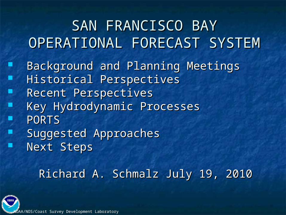
NOS 1979-1980 Circulation Survey Report 7NOS 1979-1980 Circulation Survey Report 7
R.T. Cheng, USGS retired, OFS—2d TRIMR.T. Cheng, USGS retired, OFS—2d TRIM
Customized windfield provided by F. Ludwig, Customized windfield provided by F. Ludwig, Stanford UniversityStanford Universitywebsite semi-operational---R. Smith, USGSwebsite semi-operational---R. Smith, USGS
NOAA/NOS/Coast Survey Development Laboratory

NOAA/NOS/Coast Survey Development Laboratory
Recent PerspectivesRecent Perspectives
NOS Historical Circulation Survey Data NOS Historical Circulation Survey Data Restoration CSDL Tech Note 9.Restoration CSDL Tech Note 9.
Movement towards 3d unstructured grids Movement towards 3d unstructured grids in recent model studies: unTRIM, in recent model studies: unTRIM, SUNTANS, and FVCOM.SUNTANS, and FVCOM.
San Francisco Bay-Delta UnTRIM Model San Francisco Bay-Delta UnTRIM Model Calibration Report, California Calibration Report, California Department of Water Resources, Department of Water Resources, December 2008.December 2008.

NOAA/NOS/Coast Survey Development Laboratory

NOAA/NOS/Coast Survey Development Laboratory
Key Hydrodynamic ProcessesKey Hydrodynamic Processes
Upwelling/Downwelling dynamics—California Upwelling/Downwelling dynamics—California Current (ROMS OSU and JPL models)Current (ROMS OSU and JPL models) Internal wave generation—nonhydrostatic Internal wave generation—nonhydrostatic SUNTANS and ROMS coupling (Fringer et al., SUNTANS and ROMS coupling (Fringer et al., Oceanography, 2006)Oceanography, 2006) Shelf-Bay interactionShelf-Bay interaction Salinity intrusion and Delta dynamicsSalinity intrusion and Delta dynamics Wetting-drying of tidal flats in the northern Wetting-drying of tidal flats in the northern BayBay Inundation associated with coastal stormsInundation associated with coastal storms

NOAA/NOS/Coast Survey Development Laboratory

NOAA/NOS/Coast Survey Development Laboratory

NOAA/NOS/Coast Survey Development Laboratory
USGS/NOS Real-time C/T SensorsUSGS/NOS Real-time C/T Sensors
Plans for USGS real-time C/T sensor networkPlans for USGS real-time C/T sensor network
Proposed addition of PORTS C/T sensors at Proposed addition of PORTS C/T sensors at allall PORTS water level gauges pending fundingPORTS water level gauges pending funding
Cooperation with USGS in station location Cooperation with USGS in station location selectionselection and maintenance of selected stationsand maintenance of selected stations

NOAA/NOS/Coast Survey Development Laboratory
VDATUM California Coast Grid
NOAA/NOS/Coast Survey Development Laboratory
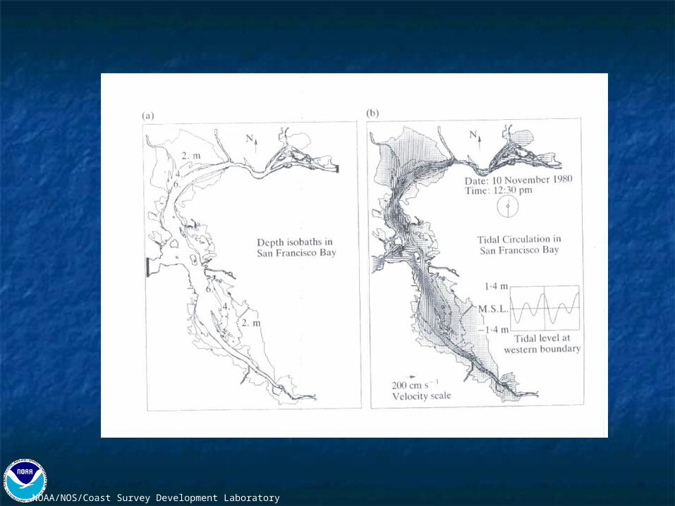
VDATUM Grid in the vicinity ofSan Francisco Bay

NOAA/NOS/Coast Survey Development Laboratory
VDATUM San Francisco Bay Bathymetry
NOAA/NOS/Coast Survey Development Laboratory
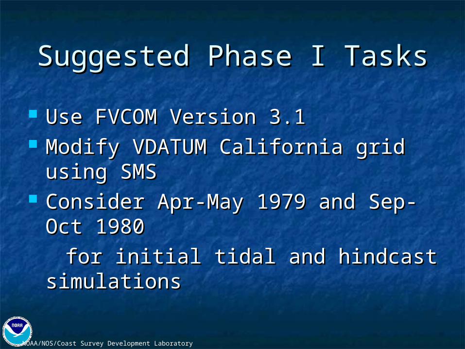
Suggested Phase I TasksSuggested Phase I Tasks
Use FVCOM Version 3.1Use FVCOM Version 3.1 Modify VDATUM California grid using Modify VDATUM California grid using
SMSSMS Consider Apr-May 1979 and Sep-Oct Consider Apr-May 1979 and Sep-Oct
19801980
for initial tidal and hindcast for initial tidal and hindcast simulationssimulations

NOAA/NOS/Coast Survey Development Laboratory
USGS/NOS Modeling USGS/NOS Modeling Cooperative EffortsCooperative Efforts
Phase I consistent with recent unstructured grid modeling Phase I consistent with recent unstructured grid modeling approaches, builds on VDATUM grid and bathymetry, and approaches, builds on VDATUM grid and bathymetry, and uses recovered historical NOS data employed by Ralph uses recovered historical NOS data employed by Ralph Cheng, USGS, for comparison of modeling results.Cheng, USGS, for comparison of modeling results.
Unstructured modeling approach allows NOS FVCOM Unstructured modeling approach allows NOS FVCOM modeling approach to be coordinated with unTRIM modeling approach to be coordinated with unTRIM modeling efforts by Jon Burau, USGS, Sacramento.modeling efforts by Jon Burau, USGS, Sacramento.
Assistance and cooperation in the development of the Assistance and cooperation in the development of the Delta inflow boundary conditions, particularly during the Delta inflow boundary conditions, particularly during the historical 1979-1980 hindcast.historical 1979-1980 hindcast.
NOAA/NOS/Coast Survey Development Laboratory
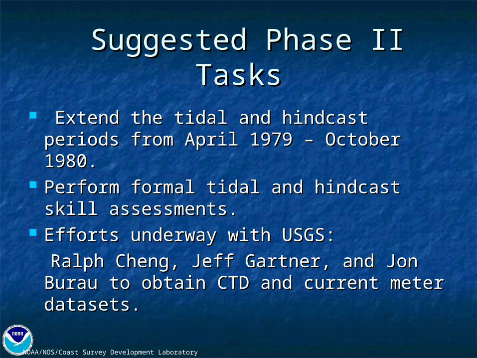
Suggested Phase II TasksSuggested Phase II Tasks
Extend the tidal and hindcast periods Extend the tidal and hindcast periods from April 1979 – October 1980.from April 1979 – October 1980.
Perform formal tidal and hindcast skill Perform formal tidal and hindcast skill assessments.assessments.
Efforts underway with USGS:Efforts underway with USGS:
Ralph Cheng, Jeff Gartner, and Jon Ralph Cheng, Jeff Gartner, and Jon Burau to obtain CTD and current meter Burau to obtain CTD and current meter datasets.datasets.

NOAA/NOS/Coast Survey Development Laboratory
Suggested Phase III TasksSuggested Phase III Tasks
Transfer and couple San Francisco Transfer and couple San Francisco Bay FVCOM to shelf forecast models Bay FVCOM to shelf forecast models at NCEPat NCEP ETSS/G-NCOM ETSS/G-NCOM NOS West Coast Shelf ModelNOS West Coast Shelf Model
Perform formal skill assessment of Perform formal skill assessment of NCEP coupled San Francisco Bay NCEP coupled San Francisco Bay FVCOM nowcasts and forecastsFVCOM nowcasts and forecasts

NOAA/NOS/Coast Survey Development Laboratory
Next StepsNext Steps
Review and edit NOS Circulation Survey Current, Review and edit NOS Circulation Survey Current, CT, and CTD datasetsCT, and CTD datasets
Obtain historical water level data 1979-1980Obtain historical water level data 1979-1980 Obtain water level and PORTS current station HA Obtain water level and PORTS current station HA
resultsresults Perform HA (15-day) on historical current dataPerform HA (15-day) on historical current data Revise VDATUM grid and bathymetriesRevise VDATUM grid and bathymetries Develop additional water level, current, and densityDevelop additional water level, current, and density
station locations---station locations--- initially measure conductivity initially measure conductivity at PORTS water level stations.at PORTS water level stations.

NOAA/NOS/Coast Survey Development Laboratory
Organization Role Comments
OCS/CSDL/MMAP Sponsor
NOS/CO-OPS Sponsor, Stakeholder, Customer
NWS/NCEP Sponsor, Stakeholder, Customer
IOOS Regional Associations Stakeholder
USGS Stakeholder
Marine navigation community End user
Emergency response community End user
Environmental management community End user
Stakeholders

NOAA/NOS/Coast Survey Development Laboratory
FY 2010 – 2015 Development and Implementation Schedule for NOS Operational Forecast Systems
Fiscal Year of Operational
Delivery
Water Body of new Operational Model
Water Body of Retrofitted
Operational Model
Hydrodynamic Model Selected
# of Operational Models on NOS
Computers
# of Operational Models on NOAA High Performance
Computers (HPC)
FY10
Tampa Bay
Delaware Bay
Chesapeake Bay
5 Great Lakes
ROMS
ROMS
ROMS
POM (GLERL)
3 8
FY11
Columbia River
Northern Gulf of Mexico (New Orleans to Mobile)
SELFE
FVCOM 3 10
FY12
Gulf of Mexico Region (Sabine Pass to New Orleans)
San Francisco
Galveston Bay(part of Northern Gulf of
Mexico)
FVCOM
ROMS or FVCOM
2 12
FY13
Eastern GOM-WFS
Puget Sound
FVCOM
FVCOM2 14
FY14
Cook Inlet
Huron Erie Corridor (GLERL) 5 Great Lakes
St. Johns River
ROMS or FVCOM
FVCOM (GLERL)
ROMS or FVCOM
1 17
FY15
Narragansett Bay/Long Island Sound
West Coast Shelf
New York/New Jersey ROMS or FVCOM
ROMS or FVCOM0
19
NOAA/NOS/Coast Survey Development Laboratory
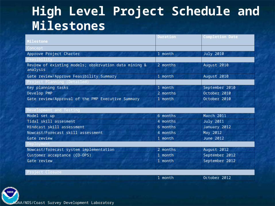
Milestone Duration Completion Date
Concept
Approve Project Charter 1 month July 2010
Feasibility
Review of existing models; observation data mining & analysis 2 months August 2010
Gate review/Approve Feasibility Summary 1 month August 2010
Project Planning (Detailed)
Key planning tasks 1 month September 2010
Develop PMP 2 months October 2010
Gate review/Approval of the PMP Executive Summary 1 month October 2010
Development and Testing
Model set up 6 months March 2011
Tidal skill assesment 4 months July 2011
Hindcast skill assessment 6 months January 2012
Nowcast/Forecast skill assessment 4 months May 2012
Gate review 1 month June 2012
Deployment
Nowcast/forecast system implementation 2 months August 2012
Customer acceptance (CO-OPS) 1 month September 2012
Gate review 1 month September 2012
Project Closure
1 month October 2012
High Level Project Schedule and Milestones

NOAA/NOS/Coast Survey Development Laboratory
Project Initiation Team Role
No. Who(if known)or TBD
% Time or Hours
Dates Needed(Date Range)
Name of Manager
MMAP Supervisor 1 Frank Aikman 10% On-going Mary Erickson
Project Manager 1 Richard Schmalz 50% 5/2010-10/2012 Frank Aikman
Physical Scientist support 1 Philip Richardson 50% 5/2010-10/2012 Frank Aikman
FVCOM Consultation 2 Changshen Chen and Robert Beardsley
60 hrs ea 7/2010-10/2012 Frank Aikman
CO-OPS transition to operations
1 Aijun Zhang 10% 7/2010-10/2012 Peter Stone
NCEP/NCO support 1 Chris Magee 10% 7/2010-10/2012 Ben Kyger
Resource Requirements for Project Planning (High Level) .


![1 background planning efforts [autosaved]](https://img.dokumen.tips/doc/110x75/554bf6cbb4c9055a368b562c/1-background-planning-efforts-autosaved.jpg)