Embed Size (px)
Citation preview
1
NATURAL HAZARD MITIGATION POLICY AND PLANFOR THE
FEDERATION OF ST KITTS & NEVIS
SECTION 1 – INTRODUCTION
1.1 Legal Framework
The Natural Hazard Mitigation Policy and Plan hereinafter called The Planhas been developed under the auspices of the United States Agency forNational Development (USAID) and the Organisation of American States(OAS) taking into account the existing legal framework of St Kitts andNevis.
The National Disaster Management Act of St Christopher and Nevis, No. 5of 1998 was passed “to provide for the effective management and control ofdisasters, and to provide for related or incidental matters.” In the Act,‘disaster management’ is defined to include “all aspects of preparedness,prevention, mitigation, planning, control, response and recovery as theyrelate to natural and technological disasters.” Provision is made for theestablishment of a National Disaster Management Agency, a corporate bodyfor co-ordinating the general policy of the Government of the Federation ofSt Kitts-Nevis in relation to disaster management. The Agency is governedby a Board of Directors {no more than nine (9) members}, all of whom areappointed by the Prime Minister of St Kitts-Nevis. Membership of the Boardincludes the Director General of the Agency, the Disaster Manager for theIsland of Nevis, and two nominees from Nevis nominated by the Premier ofthe Nevis Island Administration.
Apart from the above-mentioned legislation which speaks directly to disastermanagement (including mitigation), the legislation which governs PhysicalPlanning and Development policies also has implications for disastermitigation. This is to the extent that the nature of development (buildingcodes and land use practices) can create environmental pressures whichcould exacerbate vulnerability to natural hazards. The Planning Divisionsof St Kitts and Nevis, respectively, are authorised under the DevelopmentControl and Planning Act 2000 to exercise development control measures.The Act deals with various development issues such as the management ofdevelopment, building regulation, and management of the environmentincluding coastal waters. The National Conservation and Environment

2
Planning Act (NCEPA) 1987 covers issues relating to the preservation of theenvironment, and vests powers of administration in the NationalConservation Commission. The St Kitts-Nevis Building Code addressesbuilding regulations. Building regulations have also been incorporated intothe Development Control and Planning Act 2000.
Regulation of onsite septic tank systems which specifies minimum designand siting standards for septic tanks and drainfields is administered by theDepartment of Public Health.
Other pieces of legislation specific to Nevis with development-relatedobjectives and which have indirect implications for disaster mitigation are –(a) the Nevis Zoning Plan Ordinance 1991 which deals with land use mattersand (b) the Nevis Housing and Land Development Corporation Act 1988(1984 Act amended).
Another formal policy document which has been developed for directlyaddressing disaster management efforts is the National Disaster Plan. ThatPlan is largely response oriented and indicates strategies to be adopted bycommittees comprising representatives from various critical sectors such asHealth, Transportation, Education and Tourism, in the face of an impendingdisaster or in the event a disaster strikes. A review of the Plan reveals that itdoes not address the following areas which are key to disaster mitigation:
1. Management of Development to take into account reduction of exposureto natural hazards.
2. Strengthening of buildings and related facilities to reduce the impact ofdamage from storms.
3. Preservation of environmental features (beach, dune, and ghaut-sidesystems) for maintaining natural storm protection capabilities.
4. Management of the coastal environment to aid in the reduction ofvulnerability to disasters, with particular reference to storms.
5. Post–storm redevelopment to ensure that rebuilding efforts do not repeatmistakes made in initial development. (Hazard Mitigation and Post-Storm Redevelopment Policies in St Kitts – prepared by PhysicalPlanning Unit, Nov. 1999 )
The existing legal framework indicates a need for reviewing and updatinglegislation which is outdated. There is also the need for linking and/orintegrating current legislative policies which affect Development Planningand Environmental issues, in instances where such legislation isadministered by separate Authorities.
3
1.2 Aereal Extent of the Plan
The Plan covers the geographic area of St Kitts and Nevis.
1.3 Historical Background
Over the years, the islands of St Kitts and Nevis have been impacted by anumber of natural hazards, some of which have increased significantly infrequency over the past ten years.
1.3.1 Wind
Since 1989, as many as ten storms (see Table 1) have inflicted varyingdegrees of damage on both islands. The damage caused by those storms hasoccurred largely as a result of the impact from high velocity winds, withspeeds in excess of 75 miles per hour. Damage from these storms vary interms of magnitude and nature of the facility impacted. Damage hasincluded coastal erosion, destruction of infrastructure – roads, bridges, waterand electricity facilities, public property e.g. schools, hospitals, communitybuildings, as well as destruction of private property. Damage costs alsoinclude the opportunity cost of lost revenues due to interruption ofcommercial business activities such as tourism, a major revenue earner forthe Federation. Human lives have also been affected through physicalinjuries, psychological trauma, and indeed on occasion, actual loss of life.
Prior to 1989, the incidence of wind hazard impacting St Kitts and Nevishas been relatively infrequent compared with the later years (Table 1).

4
Table 1
Major hazards which have struck St Kitts and Nevis since 1899
Period Hazard Type Comments
1928 Hurricane
1950 Earthquake
1955 Hurricane Alice
1961 Earthquake 6+ magnitude
1974 Earthquake 7.4 Richter Scale
1984 Flood Basseterre SK only
1985 Earthquake 6.6 Richter Scale
1987 Flood (major)
1989 Hurricane Hugo
1989 Storm Felix
1989 Hurricane Gilbert
1989 Hurricane Iris
1995 Hurricane Luis
1995 Hurricane Marilyn
1996 Hurricane Bertha
1998 Hurricane Georges
1998 Flood (severe)
1999 Hurricane Jose
1999 Flood (minor)
1999 Hurricane Lenny
As can be seen from the above table, storms have been known to impact StKitts and Nevis more frequently in recent times; hence, disaster managementefforts by these islands appear to have paid more attention to storms.
5
Other natural hazards which have had varying impact on St Kitts and Nevishave been – Coastal Erosion, Flood, Volcano, Ground Shaking. Apart fromthe above mentioned hazards which have impacted both islands at one timeor another, St Kitts has been subject additionally to Inland Erosion, andNevis has been faced additionally, with the hazard of drought.
1.3.2 Coastal Erosion
St Kitts and Nevis is exposed to coastal erosion with varying degrees ofdamage, resulting from the effects of storms and storm surge. As a result ofHurricane Luis (1995), the western coastal area of Nevis suffered significantdamage through erosion brought upon by the force of waves. The westerncoastal areas of St Kitts and Nevis suffered most significantly as a result ofthe impact of Hurricane Lenny (1999) which approached from a westerlydirection, an unusual development.
1.3.3 Flood
Flooding is largely localised in St Kitts. Heavy rainfall normally results inthe overflow of Ghauts, as well as the retention of water in some sections ofBasseterre. In 1998 severe flooding of one of the Ghauts in Basseterreresulted in significant damage and one loss of life was recorded. Floodinghas been recorded in 1987 and more recently minor flooding in 1999. Priorto 1998 the last severe flooding was in 1880.
For Nevis, the Charlestown area along the Bath Ghaut has experiencedrelatively high flooding. Other areas where flooding has been experiencedinclude the Stoney Grove to Charlestown road and the NewcastleInternational Airport.
1.3.4 Volcano
The islands of St Kitts and Nevis lie along a volcanic chain passing throughthe Lesser Antilles. Cones with crater formation include Mount Olivees, theVerchilds Mountain and Mount Liamuiga. It is believed that MountLiamuiga (formerly known as Mount Misery) may have erupted in 1692 andin 1843 (Bender 1986 with reference to World Data Centre, 1981). Note –Volcanic Activity is one of the priority hazards which has been identified;however, mitigation activities specific to that hazard have not been coveredunder The Plan, as work relating to vulnerability assessment relative tovolcanic activity is being carried out by the Seismic Research Unit inTrinidad and Tobago, West Indies under the auspices of another ongoingproject.

6
1.3.5 Ground Shaking
St Kitts as well as Nevis is prone to earthquakes. Relatively minor tremorshave been felt infrequently, with little or no damage having been reported.Seismic activity is being monitored through the Seismic Research Unit inTrinidad and Tobago, West Indies, which is also carrying out updated workwith respect to vulnerability assessment of the islands as part of their widermandate. Accordingly, mitigation efforts for addressing Ground Shaking arenot included specifically in this plan.
1.3.6 Inland Erosion
Inland Erosion is identified as a critical hazard for St Kitts only. St Kitts hasbeen subject to inland erosion as a result of storm winds and ghaut flooding.The areas along ghaut levels have been susceptible to landslides and damagehas been suffered particularly in areas where sub-standard housing has beenerected, generally by squatters without official planning authority (BentleyAssociates 1998).
1.3.7 Drought
Drought has been identified as a critical hazard for Nevis only. More thanone-half of the island receives less than fifty (50) inches of rainfall per year.Rainfall per year has been known to average forty-six (46) inches ascompared to an average of 64 inches for St Kitts . Rainfall is lowest on theeastern side of the island and increases in areas of higher altitude. Althoughshort periods of drought may occur throughout the year, extended periods ofdrought are more often experienced from the months of February throughApril.
1.4 Scope and Purpose
1.4.1 Influence of Global Climate Change
Data on various environmental phenomena have indicated that globalwarming has been affecting global climate changes. Increases in globaltemperatures, a general decline in precipitation in tropical areas, and anaccompanying rise in sea levels, all symptoms of climate changes, arecompelling Governments to strengthen their responses to the concomitantrisks. Research has revealed that sea level has risen worldwideapproximately 15 – 20 cm, (6 – 8 inches) in the last century of which 2 to 7cm have been as a result of warmer ocean temperatures. Whereas pastweather patterns have been used as a guide for future weather conditions, the
7
continuing impact of global warming is reducing predictability based on pastweather patterns. The pattern shown for hazards in St Kitts and Nevis, Table1, indicates that the incidence of hazards over the last ten years could nothave been predicted based on the pattern for previous years. The process ofchange is very disruptive to the natural environment and ecological systems.The climate change disrupts planning, and forces new approaches toDevelopment Planning and Disaster Management.
1.4.2 Learning from Experiences of St Kitts and Nevis
The damage from natural hazards experienced by St Kitts and Nevis and thehigh costs associated with recovery indicate a need for a proactive approachto disaster management. Vulnerability to natural hazards is dependent onlocation, type of development and environmental conditions. Vulnerabilitywill therefore increase as communities grow and develop.
No longer is it sufficient for the Government to settle for disastermanagement strategies which speak simply to preparation just prior to thedisaster or post disaster recovery efforts. The Government of St Kitts andNevis seeks to broaden the scope of its disaster management efforts asenvisaged under the 1998 Act and include strategies which speak toenhancing hazard mitigation activities, programmes and policies. Suchstrategies are aimed at reducing the vulnerability of the population andeconomic activities in St Kitts and Nevis to natural hazards. The Plan isaimed therefore at putting forward strategies for the following areas:-
I. Developing integrated policies which govern the initial developmentand re-development process – e.g. through building codes andimproved building practices, environmental protection – so as toreduce vulnerability to natural hazards.
II. Increasing public understanding of the need and options for hazardmitigation, through public information and education programmes.
The Plan identifies Strategies, Policies and Programmes (SP&P’s) to beundertaken in order to achieve specified goals and objectives within theoverall framework of its mission. It is anticipated that projects based onthose SP&P’s would be identified and developed by the respectiveAgencies/Government Departments within their annual budgetary cycle andwould be subject to periodic review under the monitoring mechanismproposed by The Plan.

8
1.5 Mission
Taking into account the vulnerability of St Kitts and Nevis to naturalhazards, and bearing in mind the need to ensure a vibrant economy which isas resilient as possible in the face of such disasters, the Natural HazardMitigation Policy and Plan for St Kitts and Nevis seeks to foster -
(a) an environment supportive of proper building and land use practicesfor sustainable development
(b) effective co-ordination among agencies and institutions involved inguiding and directing development, and
(c) community consciousness and commitment to carrying out disastermitigation practices.
1.6 Institutional Framework for Plan Preparation
The development and adoption of The Plan is one of four objectives beingpursued under the USAID/OAS sponsored Post-Georges Disaster Mitigation(PGDM) Programme. The goal of the PGDM programme in St Kitts-Nevisis to reduce the vulnerability of the population and economic activities in StKitts and Nevis to natural hazards.
Overseeing the overall programme is the OAS PGDM technical co-ordinator, who is attached to the OAS Unit of Sustainable Development andEnvironment of the OAS office in Washington D.C. USA
At the local level, is the PGDM Programme Guidance Committee which hasbeen set up to co-ordinate the St Kitts and Nevis PGDM Programmeincluding activities relating to the preparation of The Plan. Membership ofthe committee is cross-sectoral and consists of (i) the Director of the OAS,who is the Chairperson of the Committee, (ii) the PGDM Co-Ordinatorcontracted by the OAS,(iii) representatives from the Government PlanningDivision in St Kitts, (iv) representatives from the Government PlanningDivision in Nevis, (v) a representative from the Disaster Management Officein St Kitts (vi) one from the Office of Disaster Preparedness in Nevis, (vii)representatives from various other Government Departments in St Kitts andNevis - the Tourism Department, Public Works Department, the Departmentof Environment, (viii) a representative from the Building ContractorsAssociation and (viii) the Plan Writer contracted by the OAS.
The PGDM Programme Guidance Committee reports to the NationalDisaster Mitigation Council which reports to Cabinet through theChairperson of the Council, who is the Deputy Prime Minister. The Minister
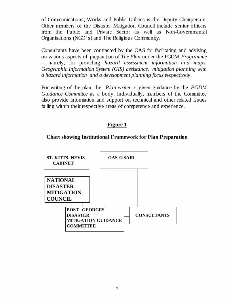
9
of Communications, Works and Public Utilities is the Deputy Chairperson.Other members of the Disaster Mitigation Council include senior officersfrom the Public and Private Sector as well as Non-GovernmentalOrganisations (NGO’s) and The Religious Community.
Consultants have been contracted by the OAS for facilitating and advisingon various aspects of preparation of The Plan under the PGDM Programme– namely, for providing hazard assessment information and maps,Geographic Information System (GIS) assistance, mitigation planning witha hazard information and a development planning focus respectively.
For writing of the plan, the Plan writer is given guidance by the PGDMGuidance Committee as a body. Individually, members of the Committeealso provide information and support on technical and other related issuesfalling within their respective areas of competence and experience.
Figure 1
Chart showing Institutional Framework for Plan Preparation
ST. KITTS- NEVIS OAS /USAID CABINET
NATIONAL DISASTER MITIGATION
COUNCIL
POST GEORGES DISASTER CONSULTANTS MITIGATION GUIDANCE COMMITTEE
10
1.7 Time Scale
The Plan covers a ten-(10) year time horizon from 2001 to 2011. Goals andobjectives are identified for the ten-year period. Programmes are developedwith a ten-year time frame in mind while it is expected that the respectiveAgencies/ Government Departments would develop projects in their annualbudgetary provisions subject to periodic review under the programme.
1.8 Methodology
Recognising that The Plan is a National Mitigation Plan, the document hasbeen developed as a broad-based consultative effort of stakeholders whoThe Plan is designed to serve. These stakeholders include the Governmentand the Government policy-making bodies, public and commercialenterprises and the general public.
Consultations were carried out with the respective parties with a view tocreating awareness of The Plan and for incorporating their ideas. ThePGDM Programme Guidance Committee provided direction for thedevelopment of The Plan. Existing legislation and policy documents whichhave implications for The Plan preparation were also reviewed.
Workshops were facilitated for the various agencies and GovernmentDepartments by OAS sponsored consultants on Hazard Mitigation Planningwith a hazard information focus as well as a development planning focus.These workshops were aimed at giving guidance to participants (who camefrom various Government agencies and Departments) for the PGDMworkplan and in particular on –
a) Identifying the priority natural hazardsb) Identifying the critical facilities, andc) Conducting a data needs assessments for the hazard mapping exercise,
identifying hazard information gaps and recommendations for fillingthose gaps.
Reports of hazard vulnerability assessments conducted by specialists(contracted by OAS) in the areas of the various priority hazards, have alsobeen included in The Plan.
The PGDM Project Guidance Committee met periodically with, andreported to the St Kitts and Nevis National Disaster Mitigation Council.
11
Public consultations on the draft plan have informed the final copy of ThePlan, taking into account the various issues and concerns raised by thepublic.
The development and implementation of the Disaster Mitigation Planenvisages collaboration among the various agencies. It also anticipatesrationalisation of various functions relating to Development Planning andDisaster Management to avoid waste of resources through duplication ofefforts. The plan envisages that rationalisation would involve centralizationof aspects relating to Development Planning while maintaining formal andoperational links with the Disaster Management Agency.

12
SECTION II – HAZARD AND VULNERABILITY ASSESSMENT
2.1 Hazard Identification and Prioritisation
A workshop1 was held to carry out a formal prioritisation exercise to identifyand prioritise natural hazards of critical importance to St Kitts and Nevis.Natural hazards which had impacted St Kitts and Nevis over the past yearswere identified. The methodology used for the prioritisation exerciseinvolved a ranking of hazards identified on a relative ranking scaleaccording to their probability, frequency, areas of impact and magnitude.The priority hazards identified were(i) Wind(ii) Drought (Nevis only)(iii) Storm Surge(iv) Volcano(v) Floods(vi) Ground Shaking(vii) Coastal Erosion and(viii) Inland Erosion (St Kitts only).
The Plan does not address Volcano and Ground Shaking as the SeismicResearch Unit in Trinidad & Tobago is currently conducting research withregard to these hazards, as well as daily monitoring of related activities.
2.2 Hazard Analysis and Vulnerability Assessment
For the priority hazards identified, Hazard Vulnerability Zone Maps anddetailed reports2 were developed by various consultants specialising in therespective hazards. The consultants examined the vulnerability of variousareas in St Kitts and Nevis to the respective hazards and maderecommendations for enhancing the hazard mitigation capability of St Kittsand Nevis relative to these hazards. These recommendations have beenincluded in the proposed programmes and policies of The Plan.
Vulnerability of critical facilities were also assessed. The following facilitieswere identified by workshop1 participants, and the PGDM GuidanceCommittee as critical:
i. Facilities which were used as Emergency Shelters
1 Rogers, C (Ph D) Natural Hazard Mitigation Workshop Report September 2000 - http://www.oas.org/pgdm2 See detailed reports and maps at http//www.oas.org/pgdm

13
ii. Hospitals and Clinics iii. Government Administrative Buildings iv. Airports, Sea ports and Bridges v. Power, Water and Telecommunication Installations vi. Oil and Gas Facilities vii. Protective Services
Note: See Appendix for the detailed list of facilities
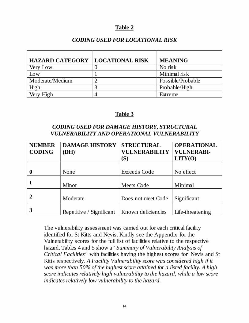
For assessing the vulnerability of the critical facilities identified, criticalvulnerability scores were developed for each of the facilities, based on avulnerability assessment process developed by Dr Cassandra Rogers, aconsultant in the area of hazard management. (see details in the Appendix ).
During a workshop attended by persons from the PGDM committeeincluding representatives from various agencies such as Physical PlanningUnits, the National Emergency Management Agency, and Public WorksDepartment of St Kitts and Nevis respectively, a hazard priority score (HPS)was computed for each of the prioritised hazards. The score took thefollowing into account –
a) Probability of occurrenceb) The frequency of occurrencec) The magnitude of the Hazardd) The area impacted upon
The Facility Vulnerability Score (FVS) was computed using the followingequation:
FVS = (L + V)HPS
Where L is the Locational risk; V is Vulnerability =DH + S + ODH is Damage History; S is Structural Vulnerability; O is OperationalVulnerability.
Hazard maps were superimposed over maps showing the location of criticalfacilities, enabling identification of the locational risk of the facility (seetable below). The Facility Vulnerability Score was then computed by theGeographic Information System.
14
Table 2
CODING USED FOR LOCATIONAL RISK
HAZARD CATEGORY LOCATIONAL RISK MEANINGVery Low 0 No riskLow 1 Minimal riskModerate/Medium 2 Possible/ProbableHigh 3 Probable/HighVery High 4 Extreme
Table 3
CODING USED FOR DAMAGE HISTORY, STRUCTURALVULNERABILITY AND OPERATIONAL VULNERABILITY
NUMBERCODING
DAMAGE HISTORY(DH)
STRUCTURALVULNERABILITY(S)
OPERATIONALVULNERABI-LITY(O)
0 None Exceeds Code No effect
1 Minor Meets Code Minimal
2 Moderate Does not meet Code Significant
3 Repetitive / Significant Known deficiencies Life-threatening
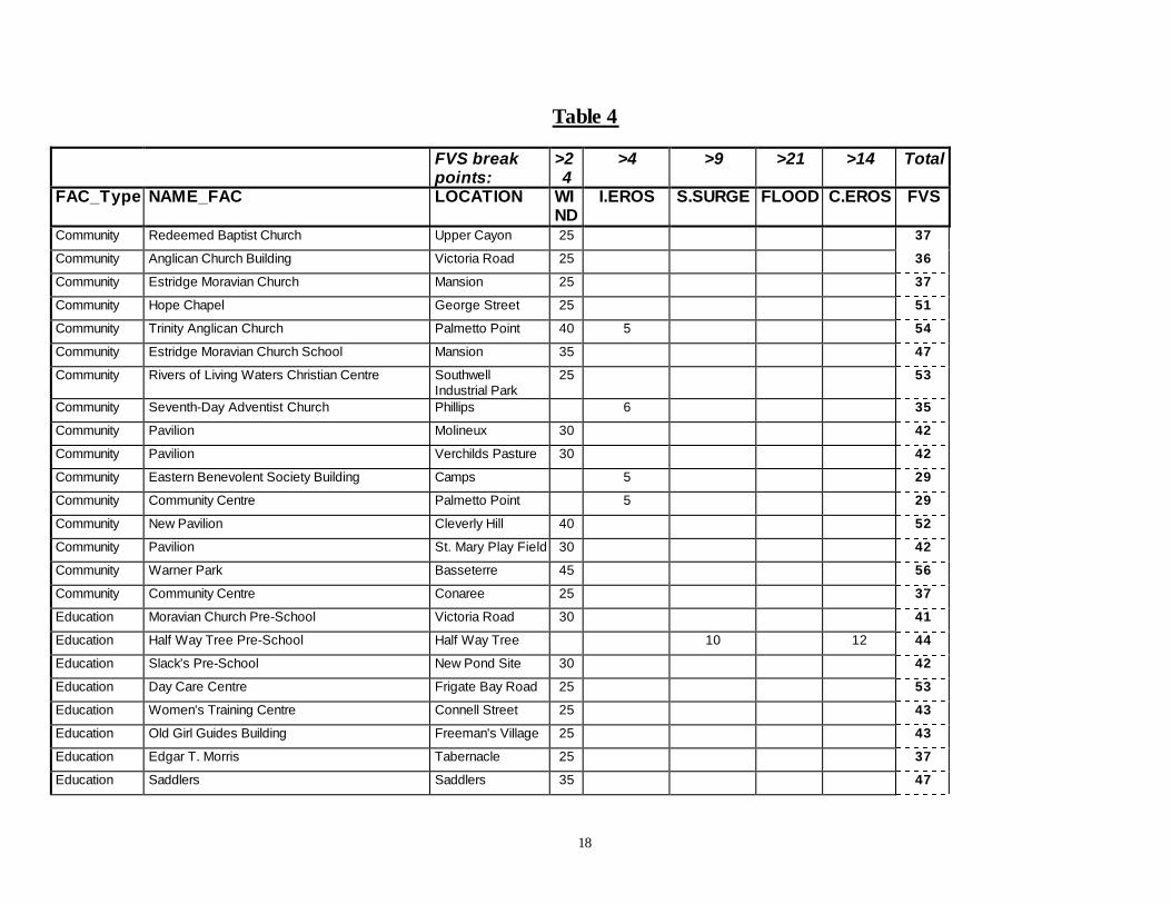
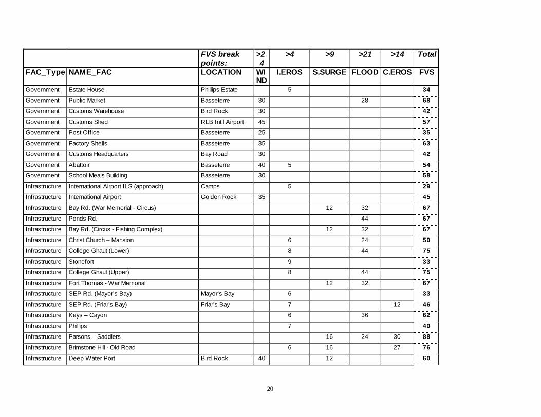
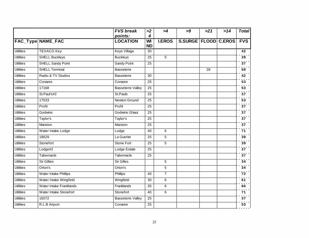
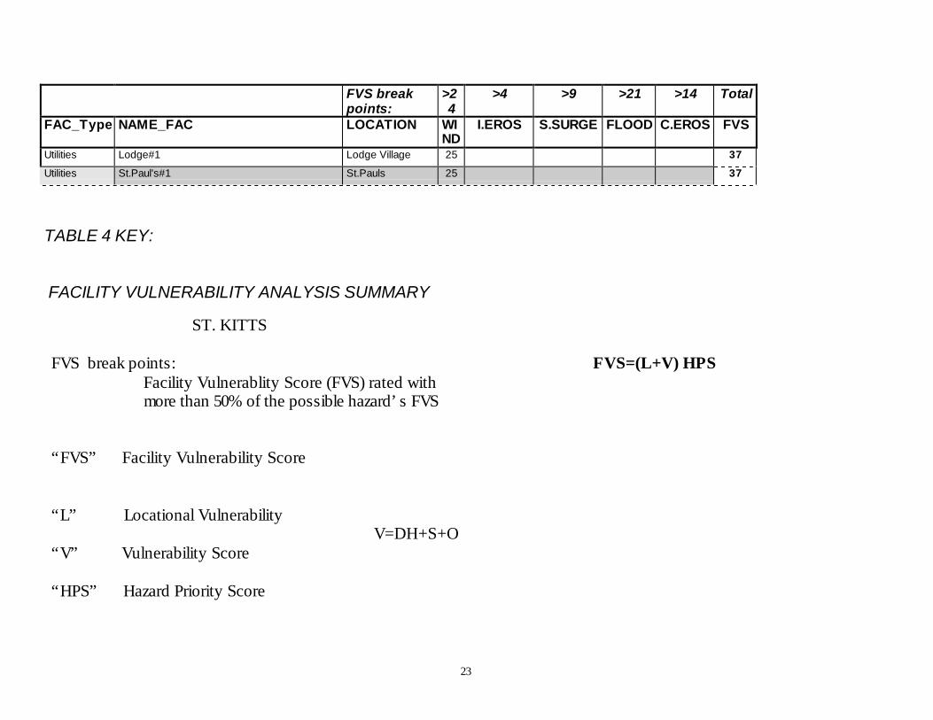
The vulnerability assessment was carried out for each critical facilityidentified for St Kitts and Nevis. Kindly see the Appendix for theVulnerability scores for the full list of facilities relative to the respectivehazard. Tables 4 and 5 show a ‘Summary of Vulnerability Analysis ofCritical Facilities’ with facilities having the highest scores for Nevis and StKitts respectively. A Facility Vulnerability score was considered high if itwas more than 50% of the highest score attained for a listed facility. A highscore indicates relatively high vulnerability to the hazard, while a low scoreindicates relatively low vulnerability to the hazard.

15
2.2.1 Hazard Analysis and Vulnerability Assessment - St Kitts
Wind
Table 4 shows that there are a number of facilities with relatively highvulnerability to wind in the areas of Basseterre, Cayon and Sandy Point.With regard to educational facilities, high scores were noted for the HighSchools of Basseterre, Verchilds and Cayon, indicating the need for a reviewof the capacity of those buildings to withstand wind from storms (includinghurricanes). Of note also of relatively high vulnerability, are two medicalfacilities, namely - the Pogson Hospital, Sandy Point and to a lesser extentthe JNF General Hospital, Basseterre.
Inland Erosion
Facilities with the highest vulnerability to Inland Erosion are spread aroundthe island, with a greater concentration towards the south. It is noted that fiveof the six main water intakes, as well as six Emergency Shelters show highvulnerability to inland erosion.
Storm Surge
Areas along the south-western seafront in particular and the stretch alongParsons to Saddlers as well as Brimstone Hill to Old Road show highvulnerability to storm surge. Other areas showing extreme vulnerability tostorm surge lie along the waterfront of Basseterre, and include The Arrivalarea of Port Zante, the Pelican Mall and the Robert L Bradshaw Building(which houses the Social Security Board).
Flood
The areas showing high vulnerability to flooding lie in the north-east ofBasseterre and include areas/roads alongside the College Street Ghaut, theBasseterre waterfront and Pond Road. Some of the critical facilities affectedinclude the Police Training Complex and buildings which are used asEmergency Shelters. It is noted that a number of the facilities which arevulnerable to storm surge are also vulnerable to flooding.
Coastal Erosion
Sections of the road along the Atlantic coast have relatively highvulnerability to beach erosion. In particular, the stretches of road along
16
Parsons to Saddlers and Brimstone Hill to Old Road, are vulnerable tocoastal erosion. These areas also have high vulnerability to storm surge.
2.2.2 Hazard Analysis and Vulnerability Assessment - Nevis
Wind
Table 5 shows that there are a number of facilities on the eastern side of theisland with relatively high vulnerability to wind including Churches andEducational facilities which are also used as Emergency Shelters. Ofparticularly high vulnerability also, are the Community Centres at Hickmanand Hard Times respectively and the Grove Park Pavilion in Charlestown.
Drought
Vulnerability to drought is spread throughout the island, with the greatestvulnerability towards the south and south-east section of the island. TheCharlestown water zone and the Butlers/Manning water zone in particularare high-risk areas.
Storm Surge
Areas along the north-eastern to south-eastern seafront have relatively highvulnerability to storm surge. It is noted that the Charlestown Port and theDeep Water Port at Long Point have relatively high vulnerability to stormsurge.
Flood
Facilities with high vulnerability to flooding are concentrated in theCharlestown area. Infrastructure of high vulnerability include the StonyGrove to Charlestown Road and the Newcastle International Airport. TheNetball Complex in Charlestown also has high vulnerability to flooding.
Coastal Erosion
Sections of the western coast have relatively high vulnerability to beacherosion. The Stony Grove to Charlestown Road which has highvulnerability to flooding is subject to high coastal erosion. The Ports ofCharlestown and Long Point which have high vulnerability to storm surgealso have high vulnerability to coastal erosion.
17
2.3 Conclusions
The hazard and vulnerability assessment indicate that a number of criticalfacilities are at high risk with respect to various hazards. The risk of somefacilities is further increased to the extent that they have high vulnerability tomore than one hazard. Mitigating these risks would involve the introductionand application of policies and the development of programmes with respectto land use practices.
18
Table 4
FVS breakpoints:
>24
>4 >9 >21 >14 Total
FAC_Type NAME_FAC LOCATION WIND
I.EROS S.SURGE FLOOD C.EROS FVS
Community Redeemed Baptist Church Upper Cayon 25 37
Community Anglican Church Building Victoria Road 25 36
Community Estridge Moravian Church Mansion 25 37
Community Hope Chapel George Street 25 51
Community Trinity Anglican Church Palmetto Point 40 5 54
Community Estridge Moravian Church School Mansion 35 47
Community Rivers of Living Waters Christian Centre SouthwellIndustrial Park
25 53
Community Seventh-Day Adventist Church Phillips 6 35
Community Pavilion Molineux 30 42
Community Pavilion Verchilds Pasture 30 42
Community Eastern Benevolent Society Building Camps 5 29
Community Community Centre Palmetto Point 5 29
Community New Pavilion Cleverly Hill 40 52
Community Pavilion St. Mary Play Field 30 42
Community Warner Park Basseterre 45 56
Community Community Centre Conaree 25 37
Education Moravian Church Pre-School Victoria Road 30 41
Education Half Way Tree Pre-School Half Way Tree 10 12 44
Education Slack's Pre-School New Pond Site 30 42
Education Day Care Centre Frigate Bay Road 25 53
Education Women's Training Centre Connell Street 25 43
Education Old Girl Guides Building Freeman's Village 25 43
Education Edgar T. Morris Tabernacle 25 37
Education Saddlers Saddlers 35 47
19
FVS breakpoints:
>24
>4 >9 >21 >14 Total
FAC_Type NAME_FAC LOCATION WIND
I.EROS S.SURGE FLOOD C.EROS FVS
Education Sandy Point Sandy Point 25 39
Education Deanne-Glasford St. Peters 30 42
Education George Moody Stuart Basseterre 30 42
Education Cayon Primary Cayon 25 37
Education Bronte Welsh Trinity 5 29
Education AVEC Building Taylor’s Range 25 37Education Sandy Point High Sandy Point 45 56
Education Washington Archibald High Taylors Range 50 62
Education Basseterre High Basseterre 45 56
Education Verchilds High Verchilds 45 57
Education Cayon High Cayon 50 62
Education Ross University Trinity 5 34
Government Customs Adm. Building Bird Rock 30 42
Government Arrivals Hall Port Zante 25 20 53
Government Pelican Mall Basseterre 30 10 48
Government Social Security Building Basseterre 6 10 32 66
Government Gov't Headquarters Basseterre 25 43
Government Treasury Building Basseterre 30 56
Government Electricity Department HQ Basseterre 25 35
Government Electricity Building Basseterre 25 43
Government O A S Building Fortlands 30 40
Government Ministry of Health & Environment Basseterre 25 35
Government Community Affairs Basseterre 25 36
Government Physical Planning, Development Bank Basseterre 25 24 55
Government Finance Department Basseterre 30 40
Government Estate House Stonefort Estate 25 5 39
20
FVS breakpoints:
>24
>4 >9 >21 >14 Total
FAC_Type NAME_FAC LOCATION WIND
I.EROS S.SURGE FLOOD C.EROS FVS
Government Estate House Phillips Estate 5 34
Government Public Market Basseterre 30 28 68
Government Customs Warehouse Bird Rock 30 42
Government Customs Shed RLB Int'l Airport 45 57
Government Post Office Basseterre 25 35
Government Factory Shells Basseterre 35 63
Government Customs Headquarters Bay Road 30 42
Government Abattoir Basseterre 40 5 54
Government School Meals Building Basseterre 30 58
Infrastructure International Airport ILS (approach) Camps 5 29
Infrastructure International Airport Golden Rock 35 45
Infrastructure Bay Rd. (War Memorial - Circus) 12 32 67
Infrastructure Ponds Rd. 44 67
Infrastructure Bay Rd. (Circus - Fishing Complex) 12 32 67
Infrastructure Christ Church – Mansion 6 24 50
Infrastructure College Ghaut (Lower) 8 44 75
Infrastructure Stonefort 9 33
Infrastructure College Ghaut (Upper) 8 44 75
Infrastructure Fort Thomas - War Memorial 12 32 67
Infrastructure SEP Rd. (Mayor's Bay) Mayor's Bay 6 33
Infrastructure SEP Rd. (Friar's Bay) Friar's Bay 7 12 46
Infrastructure Keys – Cayon 6 36 62
Infrastructure Phillips 7 40
Infrastructure Parsons – Saddlers 16 24 30 88
Infrastructure Brimstone Hill - Old Road 6 16 27 76
Infrastructure Deep Water Port Bird Rock 40 12 60

21
FVS breakpoints:
>24
>4 >9 >21 >14 Total
FAC_Type NAME_FAC LOCATION WIND
I.EROS S.SURGE FLOOD C.EROS FVS
Infrastructure Port Zante Basseterre 18 41
MedicalFacilities
Newtown Health Centre Basseterre 25 56
MedicalFacilities
Old Road Health Centre Old Road 30 41
MedicalFacilities
Sandy Point Health Centre Sandy Point 30 41
MedicalFacilities
Cayon Health Centre Cayon 30 42
MedicalFacilities
Molineux Health Centre Molineux 25 37
MedicalFacilities
St. Peter Health Centre St Peters 25 37
MedicalFacilities
Mary Charles Hospital Molineux 25 37
MedicalFacilities
JNF General Hospital Basseterre 35 5 49
MedicalFacilities
Pogson Hospital Sandy Point 45 56
Protective Fire Hall RLB Int'l Airport 25 37
Protective Fire Station Basseterre 25 52
Protective Defence Force HQ Basseterre 30 42
Protective Police Station Stapleton 35 47
Protective Police Training Complex Basseterre 45 32 85
Protective Police Station Cayon 45 57
Protective Police Station St Pauls 40 52
Protective Police Station Old Road 30 5 44
Protective Police Station St. JohnstonVillage, Basseterre
30 41
Protective Police Station Frigate Bay 25 52
Protective Police Station Tabernacle 40 52
Utilities TEXACO Buckleys Buckleys 25 5 39
22
FVS breakpoints:
>24
>4 >9 >21 >14 Total
FAC_Type NAME_FAC LOCATION WIND
I.EROS S.SURGE FLOOD C.EROS FVS
Utilities TEXACO Key Keys Village 30 42
Utilities SHELL Buckleys Buckleys 25 5 39
Utilities SHELL Sandy Point Sandy Point 25 37
Utilities SHELL Terminal Basseterre 28 59
Utilities Radio & TV Studios Basseterre 30 42
Utilities Conaree Conaree 25 53
Utilities 17168 Basseterre Valley 25 53
Utilities St.Paul's#2 St.Pauls 25 37
Utilities 17533 Newton Ground 25 53
Utilities Profit Profit 25 37
Utilities Godwins Godwins Ghaut 25 37
Utilities Taylor's Taylor's 25 37
Utilities Mansion Mansion 25 37
Utilities Water Intake Lodge Lodge 40 6 71
Utilities 18629 La Guerite 25 5 39
Utilities Stonefort Stone Fort 25 5 39
Utilities Lodge#2 Lodge Estate 25 37
Utilities Tabernacle Tabernacle 25 37
Utilities Sir Gillies Sir Gilles 5 34
Utilities Orton's Orton's 5 34
Utilities Water Intake Phillips Phillips 40 7 72
Utilities Water Intake Wingfield Wingfield 30 6 61
Utilities Water Intake Franklands Franklands 35 6 66
Utilities Water Intake Stonefort Stonefort 40 6 71
Utilities 16072 Basseterre Valley 25 37
Utilities R.L.B Airport Conaree 25 53
23
FVS breakpoints:
>24
>4 >9 >21 >14 Total
FAC_Type NAME_FAC LOCATION WIND
I.EROS S.SURGE FLOOD C.EROS FVS
Utilities Lodge#1 Lodge Village 25 37
Utilities St.Paul's#1 St.Pauls 25 37
TABLE 4 KEY:
FACILITY VULNERABILITY ANALYSIS SUMMARY
ST. KITTS
FVS break points: FVS=(L+V) HPS Facility Vulnerablity Score (FVS) rated with more than 50% of the possible hazard’s FVS
“FVS” Facility Vulnerability Score
“L” Locational Vulnerability V=DH+S+O“V” Vulnerability Score
“HPS” Hazard Priority Score

24
Table 5 NevisFacility Vulnerability Analysis Summary
FVS breakpoints:
>22 >2 >6 >14 >11 Total
FAC_Type Fac_Class FAC_ID NAME_FAC LOCATION WIND DROU S.SURGE FLOOD C.EROS FVSCommunity Church NVFC056 Zion Chapel (Emmaus) Webb's Ground 5 34Community Church NVFC063 Wesleyan Holiness Church Cotton Ground 3 32Community Church NVFC041 Roman Catholic Hall Craddock Road 4 28Community Church NVFC067 Wesleyan Holiness Church - Barnes Ghaut Barnes Ghaut 3 32Community Church NVFC066 New Testament Church of God Jessups Jessups Village 3 22Community Church NVFC062 Methodist Church Hall -Cotton Ground Cotton Ground 3 27Community Church NVFC061 Methodist Church Hall – Fountain Fountain 25 3 37Community Church NVFC059 Rehoboth Church Of God - Liburd Hill Liburd Hill 3 32Community Church NVFC057 Seventh Day Adventist Church - Butlers Butlers 25 4 38Community Church NVFC054 Calvary Baptist Church – Rawlins Hard Times 25 5 45Community Church NVFC052 Wesleyan Holiness Church - Buck Hill Bucks Hill 25 5 39Community Church NVFC065 Church Of God of Prophecy Jessups Village 3 27Community Church NVFC051 Ebenezer Church of God - Old Manor Old Manor 25 5 39Community Church NVFC050 Church of God - Cox Village Cox Village 25 5 39Community Church NVFC046 Anglican Church Fig Tree Church Ground 5 29Community Church NVFC058 Church of God - Brick Kiln Brick Kiln 4 33Community Community Centre NVFC039 Grove Park Pavilion Charlestown 40 4 62Community Community Centre NVFC042 Community Centre Bath Village 4 28Community Community Centre NVFC045 Community Centre Brown Hill 5 40Community Community Centre NVFC038 Netball Complex Charlestown 4 18 43Community Community Centre NVFC055 Community Centre – Hickmans Hickmans 30 5 44Community Community Centre NVFC047 Sports Complex Church Ground 5 29Community Community Centre NVFC053 Community Centre Hard Times Hard Times 35 5 49Education Nursery NVFC082 St.Thomas Pre-school Lowlands 3 27Education Nursery NVFC084 Vern N Llew Pre-school Charlestown 4 28Education Nursery NVFC076 Charlestown Pre-school Charlestown 4 42Education Nursery NVFC074 Brown Hill Pre-school Brown Hill 25 5 39Education Nursery NVFC073 Maude Smith Pre-school Butlers 4 33Education Nursery NVFC069 Charlestown Preparatory School Charlestown 4 28
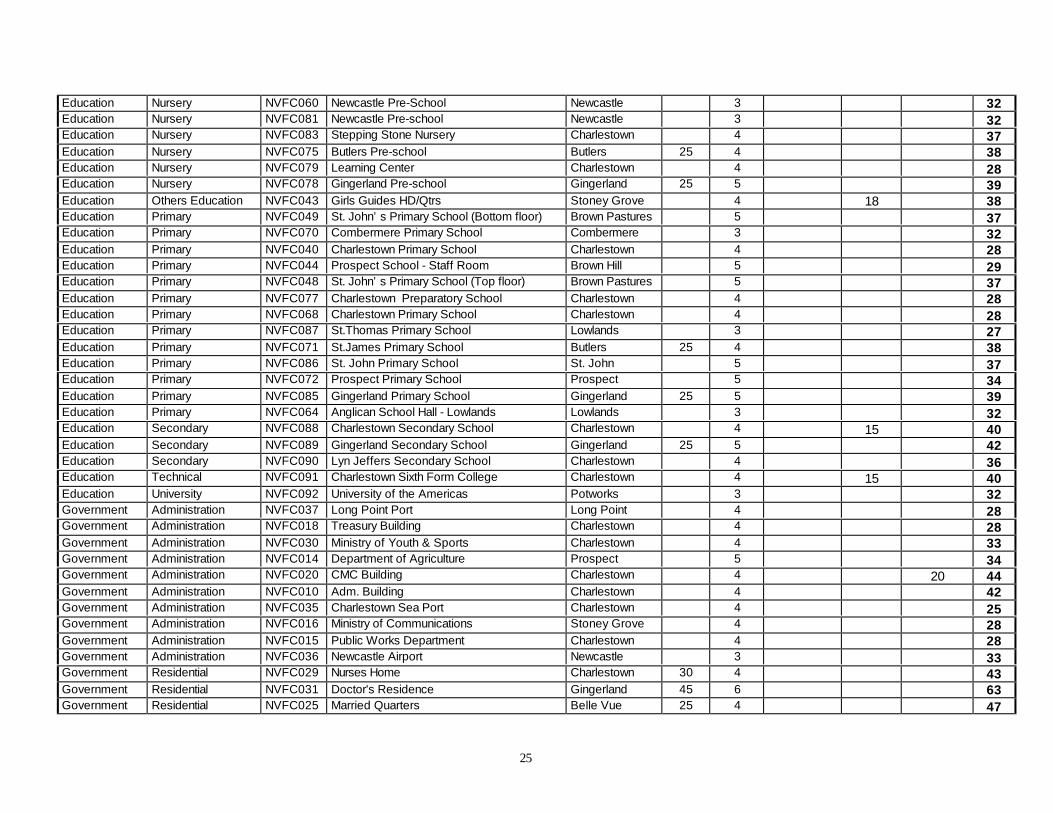
25
Education Nursery NVFC060 Newcastle Pre-School Newcastle 3 32Education Nursery NVFC081 Newcastle Pre-school Newcastle 3 32Education Nursery NVFC083 Stepping Stone Nursery Charlestown 4 37Education Nursery NVFC075 Butlers Pre-school Butlers 25 4 38Education Nursery NVFC079 Learning Center Charlestown 4 28Education Nursery NVFC078 Gingerland Pre-school Gingerland 25 5 39Education Others Education NVFC043 Girls Guides HD/Qtrs Stoney Grove 4 18 38Education Primary NVFC049 St. John’s Primary School (Bottom floor) Brown Pastures 5 37Education Primary NVFC070 Combermere Primary School Combermere 3 32Education Primary NVFC040 Charlestown Primary School Charlestown 4 28Education Primary NVFC044 Prospect School - Staff Room Brown Hill 5 29Education Primary NVFC048 St. John’s Primary School (Top floor) Brown Pastures 5 37Education Primary NVFC077 Charlestown Preparatory School Charlestown 4 28Education Primary NVFC068 Charlestown Primary School Charlestown 4 28Education Primary NVFC087 St.Thomas Primary School Lowlands 3 27Education Primary NVFC071 St.James Primary School Butlers 25 4 38Education Primary NVFC086 St. John Primary School St. John 5 37Education Primary NVFC072 Prospect Primary School Prospect 5 34Education Primary NVFC085 Gingerland Primary School Gingerland 25 5 39Education Primary NVFC064 Anglican School Hall - Lowlands Lowlands 3 32Education Secondary NVFC088 Charlestown Secondary School Charlestown 4 15 40Education Secondary NVFC089 Gingerland Secondary School Gingerland 25 5 42Education Secondary NVFC090 Lyn Jeffers Secondary School Charlestown 4 36Education Technical NVFC091 Charlestown Sixth Form College Charlestown 4 15 40Education University NVFC092 University of the Americas Potworks 3 32Government Administration NVFC037 Long Point Port Long Point 4 28Government Administration NVFC018 Treasury Building Charlestown 4 28Government Administration NVFC030 Ministry of Youth & Sports Charlestown 4 33Government Administration NVFC014 Department of Agriculture Prospect 5 34Government Administration NVFC020 CMC Building Charlestown 4 20 44Government Administration NVFC010 Adm. Building Charlestown 4 42Government Administration NVFC035 Charlestown Sea Port Charlestown 4 25Government Administration NVFC016 Ministry of Communications Stoney Grove 4 28Government Administration NVFC015 Public Works Department Charlestown 4 28Government Administration NVFC036 Newcastle Airport Newcastle 3 33Government Residential NVFC029 Nurses Home Charlestown 30 4 43Government Residential NVFC031 Doctor's Residence Gingerland 45 6 63Government Residential NVFC025 Married Quarters Belle Vue 25 4 47

26
Government Storage NVFC009 Public Market Charlestown 4 20 54Government Storage NVFC024 Government Repair Shop Prospect 5 34Government Storage NVFC012 New Castle Pottery New Castle 3 32Government Storage NVFC019 Cotton House Charlestown 4 8 15 20 62Government Storage NVFC017 Post Office Charlestown 4 28Government Storage NVFC023 Repair Shop & Garage Cades Bay 3 27Infrastructure Airport NVFC143 International Airport Newcastle 35 3 24 70Infrastructure Roads NVFC146 Stony Grove - Charlestown 5 30 20 72Infrastructure Roads NVFC148 Cades Bay - Jones Estate 3 18 12 50Infrastructure Roads NVFC147 Newcott - Jessup 4 18 20 54Infrastructure Roads NVFC149 Jones Estate - Newcastle 3 24 16 60Infrastructure Sea Port NVFC144 Charlestown Port Charlestown 4 12 24 53Infrastructure Sea Port NVFC145 Deep Water Port Long Point 4 14 20 56MedicalFacilities
Clinic NVFC097 Butlers Health Centre Butlers 4 33
MedicalFacilities
Clinic NVFC094 Charlestown Health Centre Charlestown 4 23
MedicalFacilities
Clinic NVFC098 Combermere Health Centre Combermere 3 32
MedicalFacilities
Clinic NVFC099 Cotton Ground Health Centre Cotton Ground 3 27
MedicalFacilities
Clinic NVFC096 Gingerland Health Centre Gingerland 5 34
MedicalFacilities
Clinic NVFC095 Brown Hill Health Centre Brown Hill 35 5 49
MedicalFacilities
Hospital NVFC093 Alexandra General Hospital Charlestown 30 4 15 55
Protective Court NVFC002 Magistrate’s House Charlestown 4 33Protective Court NVFC008 Courthouse/Library Charlestown 4 28Protective Fire NVFC006 Fire Hall New Castle
Airport3 38
Protective Fire NVFC007 Fire Station Charlestown 4 33Protective Police NVFC001 Police Station Charlestown 4 33Protective Police NVFC004 Police Station Gingerland 25 5 39Protective Police NVFC003 Police Station Cotton Ground 3 32Protective Police NVFC005 Police Station New Castle 3 32Protective Prison NVFC034 Prison Farm Maddens 4 33Utilities Electricity NVFC011 Power House (2 buildings) Prospect 5 34Utilities Gas NVFC106 DELTA Jessup Jessups Village 3 29Utilities Gas NVFC112 SHELL Lloyd Powell Bath Village 4 39
27
Utilities Gas NVFC113 SHELL Reliable Motors Charlestown 4 44Utilities Gas NVFC110 Govt.Garage Prospect 5 36Utilities Gas NVFC111 DELTA Noel Farm Estate 5 31Utilities Gas NVFC105 SHELL Pinney Pinney 4 30Utilities Gas NVFC108 DELTA Skiiti Newcastle 3 40Utilities Gas NVFC107 DELTA ENF Cotton Ground 3 29Utilities Gas NVFC109 DELTA Market Shop Market Shop 25 5 41Utilities Gas NVFC114 DELTA Stanley Fig Tree 5 36Utilities Petroleum NVFC103 DELTA Terminal Low Ground 4 35Utilities Petroleum NVFC104 SHELL Terminal Charlestown 4 15 12 52Utilities Telecommunication NVFC136 Church Ground Church Ground 5 35Utilities Telecommunication NVFC128 Mem's Pizzaria Mem's Pizzaria 5 35Utilities Telecommunication NVFC115 Rambury X Rambury X 4 38Utilities Telecommunication NVFC117 Newcastle X Newcastle X 3 37Utilities Telecommunication NVFC139 Newcastle Pottery Newcastle 3 33Utilities Telecommunication NVFC140 Methodist Church Liburd Hill Liburd Hill 3 33Utilities Telecommunication NVFC142 Butlers Butlers 4 39Utilities Telecommunication NVFC130 Bottom Zion Hill Zion Hill 5 40Utilities Telecommunication NVFC131 Fenton Hill Fenton Hill 5 40Utilities Telecommunication NVFC137 Hanleys Rd. Hanleys Rd. 5 40Utilities Telecommunication NVFC133 Rawlins Rawlins 5 40Utilities Telecommunication NVFC134 Chicken Stone Chicken Stone 5 40Utilities Telecommunication NVFC129 JNC Senior Home Prospect rd. Prospect Rd. 5 35Utilities Telecommunication NVFC116 Market Shop X Market Shop X 5 44Utilities Telecommunication NVFC122 Bottom Craddock Rd. Craddock Rd. 4 34Utilities Telecommunication NVFC138 Newcastle Airport Newcastle 3 15 39Utilities Telecommunication NVFC141 Jones Estate Jones Estate 3 28Utilities Telecommunication NVFC118 JNC Cotton Ground Cotton Ground 3 33Utilities Telecommunication NVFC119 JNC Jessups Jessups 3 28Utilities Telecommunication NVFC135 Strikers Car Rental Strikers rental 5 35Utilities Telecommunication NVFC121 New Cut Rd. New Cut Rd. 4 29Utilities Telecommunication NVFC124 Barclays Bank Barclays Bank 4 20 45Utilities Telecommunication NVFC123 JNC Govt. Rd. & Rd. to RMD Govt. Rd. 4 29Utilities Telecommunication NVFC125 Super Foods Super Foods 4 18 43Utilities Telecommunication NVFC127 Top of Govt. Rd. Govt. Rd. 4 29Utilities Telecommunication NVFC126 Bath Round-About Bath Round-
About4 18 43
Utilities Telecommunication NVFC132 Market Shop Market Shop 5 40

28
Utilities Telecommunication NVFC120 Four Seasons Clarke Estate Four Seasons 3 28Utilities Water NVFC021 Pump House Fothergills 25 5 39Utilities Water NVFC022 Pump House Stoney Grove 4 37
29
TABLE 5 KEY: FACILITY VULNERABILITY ANALYSIS SUMMARY
NEVIS
FVS break points: FVS = (L+V) HPS Facility Vulnerability Score (FVS) rated with More than the 50% of the possible hazard's FVS
“FVS” Facility Vulnerability Score
“L” Locational Vulnerability V=DH+S+O “V” Vulnerability Score
“HPS” Hazard Priority Score

30
SECTION III – ANALYSIS AND EVALUATION OF EXISTINGSYSTEMS
3.1 Capability Assessment
Questionnaires were sent to ten (10) Government Departments/Agenciesboth in St Kitts and Nevis. The survey was designed to assess the capabilityof Government agencies to carry out measures to mitigate the impact ofhazards in St Kitts and Nevis. Responses were received from seventypercent (70%) of the Departments/Agencies in St Kitts and fifty percent(50% ) of those in Nevis. A summary of the responses received is includedin Appendix 1.
3.1.1 St Kitts
Institutional
Responses were received from the Ministry of Tourism, Ministry ofPlanning and the Physical Planning Division, the National EmergencyManagement Agency, The Water Services Department, the Ministry ofCommunications, Works and Public Utilities, the Ministry of Health and theEnvironment, and the Royal St Christopher-Nevis Police Force. Theresponses revealed that even in some of the instances where mitigation wassaid to be carried out, the extent of such activities appeared to be limited.
Six (6) of the seven agencies from St Kitts which responded, indicated thatthey were involved in all four (4) aspects of disaster management, namely,(i) Preparation, (ii) Response, (iii) Recovery and Reconstruction and (iv)Mitigation. One of the agencies, Ministry of Tourism, indicated that it wasinvolved in Preparation, Response, and Recovery and Reconstruction only.
Legal
Disaster Management activities of the National Emergency ManagementAgency (NEMA) are governed by the Disaster Management Act 1998, whilethe activities of the Physical Planning Department of St Kitts are governedby the Development Control and Planning Act 2000. In the case of the StKitts Water Services Department, the 1959 Ordinance gives that Departmentits mandate for disaster management activities. There is no legal mandategiven to the Ministry of Tourism, the Ministry of Communications and

31
Works and the Ministry of Health and Environment for carrying out disastermanagement activities.
Political
There is awareness of, and interest in the need for disaster managementpractices for all of the agencies. For NEMA in particular, much emphasis isplaced on disaster preparation and mitigation.
Financial
Most of the respondents indicated that funding support for mitigation wasnegligible or non-existent.
Technical
All of the agencies indicated that there is need for enhancing their technicalcapability for dealing with mitigation activities.
3.1.2 Nevis
Institutional
The five (5) Agencies / Departments in Nevis, from which responses werereceived are - the Ministry of Education, the Department of Agriculture, theNevis Water Services Department, the Fire and Rescue Department and theOffice of Disaster Preparedness. All of the respondents indicated that theyare involved in the four aspects of disaster management.
Legal
There is legislation in place with regard to disaster mitigation for three (3) ofthe five (5) respondents. Although legislation is in place in the case of theWater Services Department, it was noted that the legislation is not beingenforced. In the case of the Office of Disaster Preparedness in Nevis, it wasnoted that there is need for amendment of the existing legislation.
32
Political
The various Agencies indicated that there was general interest in mitigationactivities, with the Agricultural Department, in particular, noting that there iscommitment to mitigation activities.
Financial
Relatively little, or no provision is made by the respective Agencies forfinancing of mitigation activities
Technical
While the other agencies made reference to having some technical expertise,albeit inadequate, in dealing with mitigation, the Ministry of Educationindicated that it had no technical capability.
3.2 Mitigation Opportunity Analysis
In both St Kitts and Nevis, training of personnel in different aspects ofmitigation is required in the various Agencies/Departments, for equippingthese agencies with the necessary skills. The specific skills required by eachAgency need to be identified and officers from the respective Agenciesshould be exposed to programmes with a view to upgrading their skills.
3.2.1 St Kitts
The inadequate legislative support for mitigation activities, which was citedin a number of instances, indicate a need for enhancing the legislativemandate of the respective agencies. Although, to the credit of NEMA andthe Physical Planning Division of St Kitts, the legislation granting them theirmandate was relatively recent, further review of the legislation would needto be carried out in light of the objectives and proposed programmes of thedisaster mitigation Plan. The Water Services Ordinance of 1959 would alsoneed to be updated, to take into account current circumstances. Effortsshould also be made to establish the required legislative mandates for TheMinistries of Tourism, Communication and Works, and Health andEnvironment, which had indicated that they had no legislative mandaterelative to disaster mitigation.
33
The success of disaster mitigation efforts depends to a large extent on theamount of financing available, and the technical expertise present forcarrying out various measures and programmes. Given that five (5) out ofthe seven (7) respondents in St Kitts indicated that no provision for fundingwas made for mitigation activities, Government needs to be mindful of theneed to budget for such activities.
3.2.2 Nevis
Legislation needs to be put in place where necessary, for governingmitigation practices by the respective Agencies. For the Water ServicesDepartment, efforts need to be made to enforce the existing legislation, asappropriate.
Only the Agriculture Department indicated that some, albeit small, budgetallocation was being made for disaster mitigation. This points to the need formore attention to be given to mitigation financing.
3.2.3 Summary -Capability Assessment Analysis - St Kitts and Nevis
The assessment of the capabilities of the respective Departments/Agencies issummarised in the Table below –
Table 6Summary Capability Assessment Analysis
ASSESSED AREAS RATING
INSTITUTIONAL
LEGAL
POLITICAL
FINANCIAL
TECHNICAL
Medium
Medium
Medium/High
Low
Medium
34
3.3 Conclusions
The assessment of the capabilities of the Agencies/Departments in bothSt Kitts and Nevis for handling mitigation activities revealed opportunitiesfor enhancing their capabilities in various areas. There is an awareness of,and interest in the need for carrying out mitigation activities. Theopportunity exists, however, for (a) increasing the technical capabilities ofthe agencies through training, (b) for updating and in some cases enforcingexisting regulations, and (c) increasing financial allocations for mitigation. Itis also important that information on mitigation practices be continuallydisseminated in order to heighten awareness and interest.

35
SECTION IV – PLAN FORMULATION
4.1 Goals and Objectives
The goals and objectives were developed during a workshop held for thatpurpose, for the members of the PGDM Programme Guidance Committee,and facilitated by the Planning Consultant, contracted by the OAS.
The goals and objectives articulated were subsequently submitted to the StKitts and Nevis National Disaster Advisory Committee for review andapproval.
The goals and objectives were developed, taking into account -
i. the vulnerability of St Kitts and Nevis to the priority hazards identified, ii. the existing capability of the Government Agencies to apply hazard
mitigation practices, iii. community awareness and practices with regard to hazard mitigation,
and iv. Expected future capability of St Kitts and Nevis to carry out hazard
mitigation practices, to reduce the negative impact – socially andeconomically – of natural hazards on St Kitts and Nevis.
4.1.1 Goals
I. To create a disaster resistant national environment by the reductionof vulnerability to natural hazards;
II. To improve the national capability to manage the impact of naturalhazards;
III. To develop public awareness of natural hazards and their potentialimpacts;
IV. To increase, encourage and promote effective mitigation practices;
V. To reduce the impact of natural hazards on life and property

36
4.1.2 Objectives
The objectives to be pursued under the respective goals are as follows:
Goal I – To create a disaster resistant national environment by thereduction of vulnerability to natural hazards.
4.1.2.1 Objective(s)
i. Develop a legislative framework to encourage orderly management ofdevelopment.
ii. Create a planning process that provides an environment for managementof development to reduce vulnerability to natural hazards.
iii. Ensure that the natural environment is maintained and preserved in orderto reduce the impact of natural hazards.
iv. Ensure that mitigation planning is integrated into the institutionalframework.
v. Develop a database which facilitates the continuing collection, analysisand provision of information, supportive of disaster mitigation activities.
Goal II – To improve the national capability to manage the impact ofnatural hazards.
4.1.2.2 Objective(s)
i. Review existing institutions with a view to upgrading and/or establishingnew institutions to undertake mitigation activities.
Goal III – To develop public awareness of natural hazards and theirpotential impacts.
4.1.2.3 Objective(s)
i. Provide communities with information relating to natural hazards in StKitts and Nevis, the impacts of those hazards and vulnerability ofcommunities to those impacts.

37
Goal IV – To increase, encourage and promote effective mitigationpractices.
4.1.2.4 Objective(s)
i. Develop incentive programmes which will encourage mitigationactivities to reduce vulnerability.
ii. Disseminate information supportive of mitigation practices.
iii. Develop technical training programmes
iv Increase awareness of disaster mitigation practices in the educationsector, through the development of curricula which incorporatesmitigation.
Goal V – To reduce the impact of natural hazards on life and property.
4.1.2.5 Objective(s)
i. Empower communities to take a proactive role in the reduction of theimpact of natural hazards on life and property.
ii. Increase public knowledge and awareness of mitigation practicesthrough the conduct of workshops.
4.2 Strategies, Policies and Programmes
Strategies, Policies and Programmes (SP&P’s) have been identified forenhancing the disaster mitigation capability and practices of St Kitts andNevis. These SP&P’s take into account the experiences of St Kitts and Nevisas well as recommendations made by the consultants specialising in therespective hazards.
Consultations were held with the Government Line Ministries/ Departmentsin a workshop-type setting, for reviewing and making recommendationswith respect to the following: -
(i) The Goals and Objectives outlined in The Plan and

38
(ii) The Strategies, Policies and Programmes (SP&P’s)
The SP&P’s also incorporate recommendations made during theaforementioned Consultations as well as Public Consultations held in StKitts and Nevis – one in each island.
Schedules 1 and 2 outline various strategies, policies and programmesrecommended for enhancing the disaster mitigation capability and practicesof St Kitts and Nevis. Schedule 1 identifies SP&P’s for mitigating againstthe hazards in general, while Schedule 2 addresses mitigation activitiesspecific to the priority hazards relative to St Kitts and Nevis.
The SP&P’s take into account the following considerations:
i. Legal and Regulatory framework , instruments governing Land Use aswell as the mandate of the respective Agencies which are chargedwith monitoring.
ii. The capacity and capability of the respective Government Agenciesfor carrying out mitigation activities
iii. Influencing Environmental Conditions – relative to the level ofdevelopment, susceptibility to the various Hazards, and vulnerabilityto damage
iv. Incentives for encouraging appropriate behaviours by Governmentagencies, private organisations and the general public
Projects are to be developed by the respective Government AgenciesDepartments based on the SP&P’s outlined. The Agencies Departmentsresponsible for developing and carrying out the projects based on theSP&P’s would be identified by the Government through the NationalDisaster Mitigation Council which includes senior representatives from allof the Government Agencies / Departments.
The following are SP&P’s which are to be carried out in order to attain therespective goals and objectives:
4.2.1 Goal I: To create and continually improve a disaster resistant environmentby reduction of vulnerability to natural hazards.
4.2.1.1 Objective i. Develop Legislative Framework to encourage orderlymanagement of development

39
a) Pass Development Regulations for the Development Control PlanningAct 2000 (St Kitts)
b) Pass Development Control Planning Act and Development ControlPlanning Regulations for Nevis.
c) Review existing incentives to hotels to take into consideration mitigationpractices.
d) Put systems in place for periodic review and update of legislation,regulations and policies (e.g The Development Control and Planning Act2000, and the Building Code) to ensure that they remain relevant.
4.2.1.2 Objective ii. Create a planning process that provides an environmentfor the management of development to reduce vulnerability to naturalhazards
a) Produce local area plans (including maps) taking into account mitigation,vulnerability and hazard mapping already established under this project.
b) Produce a new Land Use map for St Kitts & Nevis taking into accountthe restructuring of the St Kitts Sugar Manufacturing Corporation.
c) Develop local area plans and guidelines for areas that are prone todisaster.
d) Monitor climate change for informing Land Use and Development plans,as part of developing a proactive approach to planning.
4.2.1.3 Objective iii. Ensure that the natural environment is maintained andpreserved in order to reduce the impact of natural hazards.
a) Referring to the National Conservation and Environment Protection Act(NCEPA) of 1987, re-establish and re-activate the National ConservationCommission.
b) Ensure that Environmental Impact Assessments (EIA’s) are completedfor all new developments
c) Develop and /or enforce specific regulations relative to the environmente.g. sand mining, protection of natural waterways, waste water disposal,solid waste management.
d) Develop an environmental management plan incorporating regularscientific monitoring of various sectors of the environment.
4.2.1.4 Objective iv. Ensure that mitigation planning is integrated into theinstitutional framework.

40
a) Ensure that full use is made of Geographic Information System (GIS) &Hazard maps produced under this project when consideringEnvironmental impact assessments.
b) Integrate hazard mitigation planning with Land Use and Developmentplanning, e.g mitigation planning housing with development planning.
c) Put systems in place to facilitate co-ordination and collaboration amongthe various departments/agencies which have responsibilities forplanning and development, e.g among the Physical PlanningDepartment, the Department of Lands and Housing, the NationalHousing Corporation and the Public Works Department.
4.2.1.5 Objective v. Develop a database which facilitates the continuingcollection, analysis & provision of information, supportive of disastermitigation activities
a) Upgrade the existing GIS database for St Kitts & Nevis and provideintegrated networking facilities across sectors e.g. Intranet GIS . The database should be aimed ultimately at including all buildings in St Kitts &Nevis
4.2.2 Goal II: To improve the national capability to manage the impact ofnatural hazards.
4.2.2.1 Objective i. Review existing organisations as well as upgrade and/ orestablish new organisations to undertake mitigation activities
a) Construct a new Emergency Operating Centre for the NationalEmergency Management Agency (NEMA)
b) Maintain and /or retrofit existing emergency shelters to ensurecompliance with the Building Code. Where necessary, build new sheltersin accordance with the Building Code.
c) Review Disaster Management Office staffing and other resources (suchas equipment) in St Kitts and Nevis to ensure that mitigation capacity isadded along with other staffing requirements.
d) Increase the Building Inspectorate capability in terms of manpower andrequired qualifications
e) Ensure that the Planning Offices of St Kitts & Nevis are adequatelystaffed, housed, & equipped to address mitigation issues.
41
f) Ensure that the provision under the Building Code for qualification ofcontractors is rigidly enforced.
g) The essential services – Ministry of Communication, Works & PublicUtilities (water, electricity, and Public Works), as well as the NationalRadio and the Ministry of Health should be adequately staffed, equippedand funded to carry out their vital mitigation tasks.
4.2.3 Goal III: To develop public awareness of natural hazards and theirpotential impacts
4.2.3.1 Objective i. Provide communities with information relating tonatural hazards in St Kitts & Nevis, the impacts of those hazards andvulnerability of communities to those impacts
a) Publicise The Plan for informing the public of the hazard andvulnerability assessments, as well as activities which are beingundertaken, and can be carried out for disaster mitigation. The publicityawareness programmes is also aimed at encouraging the public to carryout mitigation activities.
b) Develop mitigation awareness programmes to empower NGO’s,community-based organisations, Festival Committees and other culturaland social groups to carry out mitigation practices
c) Each district should develop a Community Contingency Plan asappropriate to potential disasters in that Community
d) District committees and other Agencies should develop and plan periodicawareness programmes/activities to enhance mitigation practices.
e) Encourage the introduction of hazard mitigation awareness activities inCommunity and National Festivals.
4.2.3.2 Objective ii. Increase public knowledge and awareness of mitigationpractices.
a) Hold public meetings/fora, workshops to make the public aware ofmitigation practices, taking the opportunity to highlight good mitigationpractices

42
4.2.4 Goal IV: To increase, encourage, and promote effective mitigationpractices
4.2.4.1 Objective i. Develop incentive programmes which will encouragemitigation activities to reduce vulnerability
a) Encourage the formation of a private sector committee amongstakeholders e.g. Banks, Insurance Companies, mortgage Companies andunderwriters to develop mitigation criteria which can assist in decisionmaking e.g. a loan for- - a home would be conditional upon the housing plan includinghurricane clips and proper ties between the walls and the foundation
b) Gov’t and Lending Institutions should consider providing incentives tosmall business and entrepreneurs including farmers and fishermen whoadopt mitigation practices in their loan and development application- a minimum period for deferring loan payments on loans taken to repairdamage resulting from hazard
c) Government should consider granting incentives to house owners whoadopt mitigation practices, e.g where shutters have been usedconsideration may be given to adjusting Land and House Tax payments.
d) Review the incentive regime to the Tourism Sector with a view togranting incentives to those who meet mitigation requirements.
4.2.4.2 Objective ii. Disseminate information supportive of mitigationpractices
a) Publicize the Building Code and Guidelines and aggressively advertisethe procurement / availability to the construction sector
b) Disseminate brochures, fliers and multi-media products to raiseawareness of mitigation
4.2.4.3 Objective iii. Develop Technical Training Programmes
a) Government should facilitate and develop Training in Disaster Mitigationwherever the need has shown up through the capability assessment.
b) Provide ongoing training for Emergency Shelter managers, includingsuch areas as management of people and other resources and dealing withissues of security.

43
c) Conduct Training programmes for the construction industry (e.g. buildingcontractors, architects). Such training should include courses on sitepreparation for helping to minimize environmental damage.
4.2.4.4 Objective iv. Increase awareness of disaster mitigation practices inthe education sector, through the development of curricula whichincorporates such practices.
a) Hold workshops to sensitise teachers to mitigation practices.b) Encourage the holding of programmes in school which reflect support
for mitigation practices.c) Integrate Disaster Mitigation practices into relevent subject areas.
4.2.5 Goal V : To reduce the impact of natural hazards on life and property
4.2.5.1 Objective i. Empower communities to take a proactive role in thereduction of the impact of natural hazards on life and property
a) Implement the Shelter Management Policy ensuring that the Public isaware of those aspects which would advise them of actions which may betaken to reduce possible damage.
b) Hold simulation exercises periodically, so that the public becomes morealert to actions which may be taken for reducing the impact of naturalhazards.
c) Offer programmes relating to disaster planning by families and stressmanagement.
4.2.5.2 Objective ii. Reduce personal injury and loss of life as well asdamage to existing and future development.
b) Distribution lines for essential services (e.g. electricity) should be laidsub-surface
While the aforementioned mitigative SP&P’s reflect approaches which maybe taken for hazards generally for St Kitts and Nevis, consideration needs tobe given to SP&P’s relative to specific hazards, for St Kitts and Nevisrespectively. These SP&P’s, summarised in Schedule 1 are as follows:

44
4.2.6 ST KITTS AND NEVIS
4.2.6.1 Wind and Storm Surge
i. Strengthen and reinforce the structure of public buildings along withaccompanying facilities such as water and power distribution lines,and roads.
ii. Encourage communities to strengthen and reinforce private-ownedstructures.
4.2.6.2 Flood
i. Frequent ghaut maintenance, in particular at road crossings.ii In sizing culverts and bridges, pay attention to the extra waterway area
for sediment deposition.iii Develop appropriate design for silt traps and trash racks.iv. Consider diverting the lower reach of College street Ghaut, St Kitts,
away from its current alignment through the town centre. As a furtherconsideration, an economic analysis should be carried out comparing(a) likely savings in averted losses with (b) likely lost revenue becauseof postponement of planned development due to the flooding
v. Institute an ‘Early Warning System’ (EWS) to alert residents ofpending flood wave. EWS may be based on measurement of rainfall inthe upper parts of the ghauts and an awareness of the soil saturationlevels.
vi. Nevis Airport- Consider diverting crossings to the end of the runway,since the present arrangement of construction of a steel cage at theentrance of the culvert contributes to flooding when debris becomesentangled
vii. Enforce Land Use Zoning Regulations, especially in the HermitageRegion, Nevis.
It is important to note that in St Kitts where the sugarcane plantations arereplaced by housing developments, one needs to be mindful of the increasedrunoff downstream and the potential for greater velocities which mayaggravate erosion.

45
4.2.6.3 Coastal erosion
i Perform preliminary selection of coastal areas for sand mining,tourism and housing development, coastal structures andinfrastructure development, taking into account coastal areas that haveshown historical patterns of erosion and are likely to display similarpatterns in the future.
ii. Develop strategies for addressing problems relating to coastal erosione.g. for prioritising beaches for sandmining. Further work in this areamay include an investigation of seasonal erosion and accretionpatterns may be carried out for guiding the development of a rotationsystem for sand mining.
iii. Sensitise the general public about coastal erosion and associatedimpacts.
iv. Prioritise the allocation of resources for erosion defense, increasedmonitoring and/ or further research of coastal dynamics.
4.2.7 ST KITTS
4.2.7.1 Inland erosion
i. Institute and implement policies with respect to land use managementii Develop and invest in programmes for informing farmers and the
public on good conservation practices for minimising fertility loss andavoiding the problems created by sedimentation.
iii. Review Town and Country Planning policies and practices, to avoid/reduce the need for correctional action –(e.g. the need for reworkingof stream banks, and natural excavation of stream courses by thestream in spate indicate that planning has been neglected.a) Avoid the building of roads across an occasional stream without
providing adequate culvertsb) House construction within a gully or on the edge of vertical stream
banks in weak materials should not be allowed.c) Identify sites which are subject to earthquake induced rock falls.
iv. Plan adequate drainage systems and monitora) Plan drainage systems to deal with a whole sub-catchmentb) Keep drainage ways clean of impediments
46
v. Take action in response to Land Use Changea) Planners and developers need to consider that converting a pieceof land under bush into dwelling house lots results in a markedreduction in the way water enters the soil and hence greater run-off ofwater, with a likelihood of greater land erosion.
vi. Retain windbreaks, avoid large areas of exposed soil, through the usee.g. of vegetation slips
vii. Monitor and avoid areas at hazardviii. Provide cut off-drainsix. Use stabilising techniques which may be a costly approach and
therefore used as a last resort
4.2.8 NEVIS
4.2.8.1 Drought
i. Develop and monitor indicators for future identification of drought,e.g. –Meteorological/ Environmentala)Wilting as grass roots becomes progressively damaged by lack ofsoil waterb)Increase in leaf fallc)Damage (dried leaves / broken stems) to ‘indicator’ plant speciese.g. cacti which utilise stored water in dried periods.
Hydrologicald) Monitor water levels by measuring data such as rainfall,temperature, wind speed, evaporation and seepage.e) Ration water before ground water levels recede to critical points.
ii. Develop policies relative to:a) Cost of water for irrigation.b) Regulation of livestock grazing and livestock population densities.c) Incentives for water and soil conservation practices.d) Drought Insurance.e) Drought relief programmes.
47
Further work for mitigating the effects of drought may need to placeemphasis on
i. identifying more appropriate boundaries for water resources anddrought management, through a thorough analysis of drainage basinson the island
ii. Developing data to accurately predict the gap in time betweenrecovery from meteorological / agricultural drought and thereplenishment of water to average levels.
47
Schedule 1PLAN FORMULATION SCHEDULE - STRATEGIES, POLICIES, PROGRAMMES
GOAL I: TO CREATE AND CONTINUALLY IMPROVE A DISASTER RESISTANTENVIRONMENT BY REDUCTION OF VULNERABILITY TO NATURAL HAZARDS
OBJECTIVES STRATEGIES /POLICIES/PROGRAMMES
ACTION BY - AGENCY(NAME)
i. Develop Legislative Framework toencourage orderly management ofdevelopment
Ii. Create a Planning process thatprovides an environment for themanagement of development such thatvulnerability to natural hazards isreduced.
Iii. Ensure that the natural environmentis maintained and preserved in order toreduce the impact of natural hazards.
Iv. Ensure that mitigation planning isintegrated into the institutionalframework
v. Develop a database which facilitatesthe continuing collection, analysis &provision of information, supportive ofdisaster mitigation activities
a) Pass Development Regulations for theDevelopment Control Planning Act (St Kitts).
b) Pass Develop. Control Plan Act for Nevis &Develop. Regulations (Nevis)
c) Review existing incentives to hotels taking intoconsideration mitigation practices.
d) Put system in place for facilitating periodicreview and update of legislation, regulations,and policies.
a) Produce Local Area Plans (including maps)taking into account mitigation, vulnerabilityand hazard mapping already established underthis project.
b) Produce a Land Use map for St Kitts & Nevistaking into account the restructuring of the StKitts Sugar Manufacturing Corporation.
c) Produce Local Area Plans and guidelines forareas which are prone to disaster.
d) Monitor climate change for informing land useand development plans.
a) Referring to the NCEP Act of 1987, re-establish and re-activate the NationalConservation Commission.
b) Ensure that EIA’s are completed for all newdevelopments
c) Develop and /or enforce specific regulationsand Environmental Management Plans, e.g.relating to sand mining, waste water disposal.
a) Ensure that full use is made of GeographicInformation System (GIS) & Hazard mapsproduced under this project when consideringenvironmental impact assessments.
b) Develop systems for facilitating co-ordinationand collaboration among Planningdepartments/agencies
a) Upgrade the existing GIS database and provideintegrated networking facilities across sectorse.g. Intranet GIS . The data base should beaimed ultimately at including all buildings inSt Kitts & Nevis.

48
GOAL II : TO IMPROVE THE NATIONAL CAPABILITY TO MANAGE THE IMPACT OFNATURAL HAZARDS
OBJECTIVES STRATEGIES /POLICIES/PROGRAMMES
ACTION BY -AGENCY (NAME)
i. Review existing organisations as wellas upgrade and/ or establish neworganisations to undertake mitigationactivities
a) Construct a new Emergency OperatingCentre for NEMA
b) Maintain & /or retrofit existing emergencyshelters to ensure compliance with theBuilding Code
c) Review Disaster Management Office staffingand other resources (e.g. equipment) in StKitts & Nevis to ensure that mitigationcapacity is added along with other staffingrequirements.
d) Increase the Building Inspectorate capabilityin terms of manpower and requiredqualifications
e) Ensure that the Planning Offices of St Kitts& Nevis are adequately staffed, housed, &equipped to address mitigation issues.
f) Ensure that the provision under the BuildingCode for qualification of contractors isrigidly enforced.
g) The essential services – Ministry ofCommunication, Works & Public Utilities(water, electricity, and public works) and theNational Radio should be adequately staffed,equipped and funded to carry out their vitalmitigation tasks.
h) Distribution lines for essential services (e.g.electricity) should be laid sub-surface.
49
GOAL III : TO DEVELOP PUBLIC AWARENESS OF NATURAL HAZARDS AND THEIRPOTENTIAL IMPACTS
OBJECTIVES STRATEGIES /POLICIES/PROGRAMMES
ACTION BY -AGENCY (NAME)
i. Provide communities with informationrelating to natural hazards in St Kitts &Nevis, the impacts of those hazards andvulnerability of communities to thoseimpacts
Ii Increase public knowledge andawareness of mitigation practices.
a) Publicise The Planb) Each district should develop a
Community Contingency Plan asappropriate to potential disasters in thatCommunity
c) District committees and other agenciesshould develop & plan periodicawareness programmes/activities toenhance mitigation practices.
d) Encourage the introduction of hazardmitigation awareness activities inCommunity and National Festivals.
e) Develop mitigation awarenessprogrammes to empower NonGovernmental Organisations (NGO’s),community-based organisations, FestivalCommittees and other cultural and socialgroups.
a) Hold public meetings/fora, workshops tomake the public aware of mitigationpractices, taking the opportunity tohighlight good mitigation practices.
50
GOAL IV: TO INCREASE , ENCOURAGE, AND PROMOTE EFFECTIVE MITIGATIONPRACTICES
OBJECTIVES STRATEGIES /POLICIES/PROGRAMMES
ACTION BY - AGENCY(NAME)
i. Develop incentive programmes whichwill encourage mitigation activities toreduce vulnerability
Ii. Disseminate information supportive ofmitigation practices
Iii. Develop Technical TrainingProgrammes
iv. Increase awareness of disastermitigation practices in the educationsector, through the development ofcurricula which incorporate mitigation.
a) Encourage the formation of a privatesector committee among stakeholders e.g.Banks, Insurance Companies, Mortgagecompanies and underwriters to developmitigation criteria which can assist indecision-making e.g. a loan for- - a home would be conditional upon thehousing plan including hurricane clips andproper ties between the walls and thefoundation
b) Gov’t and Lending Institutions shouldconsider providing –incentives to smallbusiness owners and entrepreneursincluding farmers and fishermen whoadopt mitigation practices in their loanand development application- a minimum period for which loan re-payments on loans taken to repair damageresulting from hazards is deferred.
c) Review the incentive Regime to theTourism Sector with a view to grantingincentives to those who meet mitigationrequirements.
a) Publicise the Building Code andGuidelines, and aggressively advertise theprocurement / availability to theconstruction sector
b) Disseminate brochures, fliers and multi-media products to raise awareness ofmitigation
a) Government should facilitate Training (toinclude simulation) in Disaster Mitigation -– wherever the need has shown upthrough the capability assessment.- for persons in the Construction sectorincluding in particular site preparation anddevelopment.
a) Hold workshops to sensitise teachers tomitigation practices.
b) Encourage holding programmes (forstudents) in schools which reflect supportfor mitigation practices
51
GOAL V : TO REDUCE THE IMPACT OF NATURAL HAZARDS ON LIFE ANDPROPERTY
OBJECTIVES STRATEGIES /POLICIES/PROGRAMMES
ACTION BY - AGENCY(NAME)
i. Empower communities to take aproactive role in the reduction of theimpact of natural hazards on life andproperty
ii Reduce personal injury and loss of life as well as damage to existing and future development.
a) Ensure that the public is aware of theShelter Management Policy,particularly those aspects which wouldinform them of actions to be taken toreduce possible damage.
b) Hold simulation exercises periodically.c) Offer programmes relating to disaster
planning by families and stressmanagement.
a) Distribution lines for essential service (e.g. electricity) should be laid sub-surface.
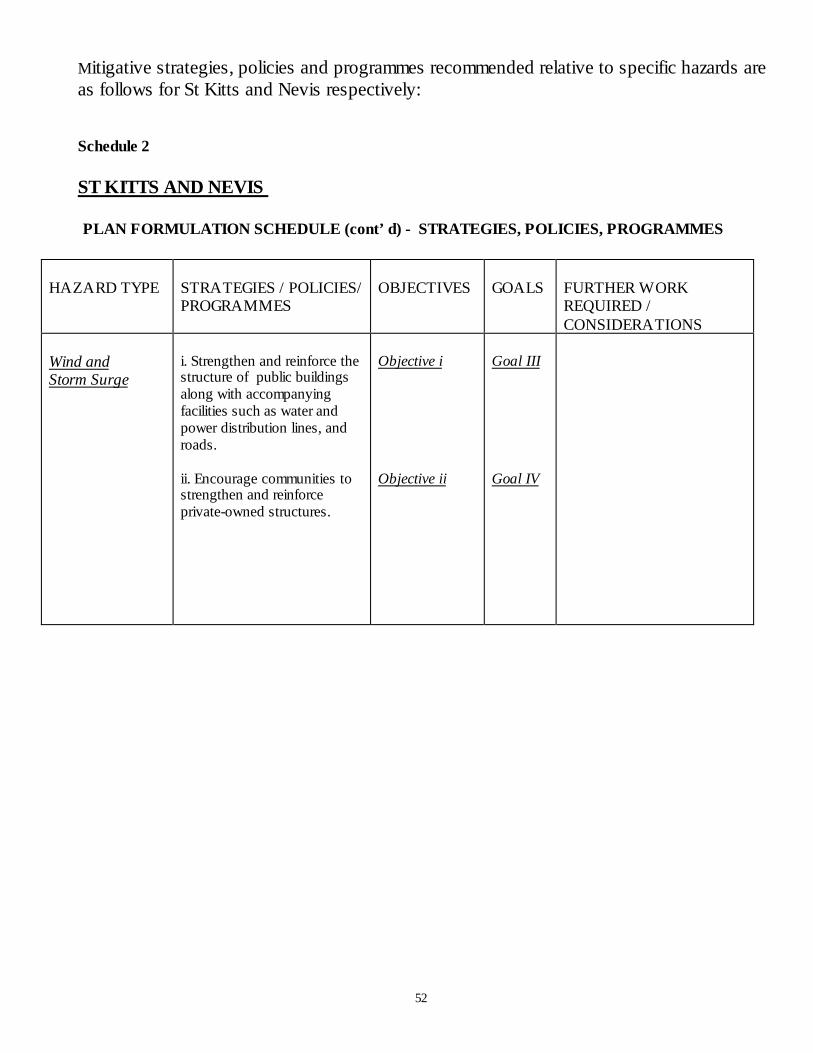
52
Mitigative strategies, policies and programmes recommended relative to specific hazards areas follows for St Kitts and Nevis respectively:
Schedule 2
ST KITTS AND NEVIS
PLAN FORMULATION SCHEDULE (cont’d) - STRATEGIES, POLICIES, PROGRAMMES
HAZARD TYPE STRATEGIES / POLICIES/PROGRAMMES
OBJECTIVES GOALS FURTHER WORKREQUIRED /CONSIDERATIONS
Wind andStorm Surge
i. Strengthen and reinforce thestructure of public buildingsalong with accompanyingfacilities such as water andpower distribution lines, androads.
ii. Encourage communities tostrengthen and reinforceprivate-owned structures.
Objective i
Objective ii
Goal III
Goal IV

53
ST KITTS AND NEVIS
PLAN FORMULATION SCHEDULE (cont’d) - STRATEGIES, POLICIES, PROGRAMMES
HAZARD TYPE STRATEGIES/POLICIES/PROGRAMMES
OBJECTIVES GOALS FURTHER WORKREQUIRED/CONSIDERATIONS
FLOOD I. Frequent Ghautmaintenance, in particularat road crossings
Ii. In sizing culverts andbridges, pay attention tothe extra waterway areafor sediment deposition
Iii. Develop appropriatedesign for silt traps andtrash racks.
Iv. Consider diverting thelower reach of CollegeStreet Ghaut, St. Kittsaway from its currentalignment through thetown centre.
v. Nevis Airport -Consider divertingcrossings to the end of therunway, since the presentarrangement ofconstruction of a steelcage at the entrance of theculvert contributes tofloodingwhen debris becomesentangled
v. Enforce Land useZoning Regulations,especially in theHermitage Region, Nevis
Objective ii Goal I Consideration to replace thesugarcane plantations in St.Kitts by housingdevelopments need to bemindful of the increasedrunoff downstream and thepotential for increasedvelocities and thereforegreater erosion potentialwithin the ghauts.
With regard to Programme(iv) carry out economicanalysis comparing (a) likelysavings in averted losseswith (b) likely lost revenuedue to postponement ofplanned development onaccount of flooding
Re. Programme (v) – EWSmay be based onmeasurement of rainfall inthe upper parts of the ghautsand an awareness of the soilsaturation levels
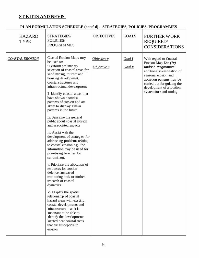
54
ST KITTS AND NEVIS
PLAN FORMULATION SCHEDULE (cont’d) - STRATEGIES, POLICIES, PROGRAMMES
HAZARDTYPE
STRATEGIES/POLICIES/PROGRAMMES
OBJECTIVES GOALS FURTHER WORKREQUIRED/CONSIDERATIONS
COASTAL EROSION Coastal Erosion Maps maybe used to:i Perform preliminaryselection of coastal areas forsand mining, tourism andhousing development,coastal structures andinfrastructural development
ii Identify coastal areas thathave shown historicalpatterns of erosion and arelikely to display similarpatterns in the future.
Iii. Sensitise the generalpublic about coastal erosionand associated impacts
Iv. Assist with thedevelopment of strategies foraddressing problems relatingto coastal erosion e.g. theinformation may be used forprioritising beaches forsandmining.
v. Prioritise the allocation ofresources for erosiondefence, increasedmonitoring and/ or furtherresearch of coastaldynamics.
Vi. Display the spatialrelationship of coastalhazard areas with existingcoastal developments andinfrastructure – as it isimportant to be able toidentify the developmentslocated near coastal areasthat are susceptible toerosion
Objective v
Objective ii
Goal I
Goal V
With regard to CoastalErosion Map Use (1v)under .’.Programmes’additional investigation ofseasonal erosion andaccretion patterns may becarried out for guiding thedevelopment of a rotationsystem for sand mining.

55
ST KITTS
PLAN FORMULATION SCHEDULE (cont’d) - STRATEGIES, POLICIES, PROGRAMMES
HAZARD TYPE STRATEGIES/POLICIES/PROGRAMMES
OBJECTIVES GOALS FURTHER WORKREQUIRED/CONSIDERATIONS
INLAND EROSION i. Institute and implementpolicies with respect to landuse management.
ii Develop and invest inprogrammes for informingfarmers and the public ongood conservation practicesfor minimising fertility lossand avoiding the problemscreated by sedimentation.
iii. Review Town andCountry Planning policiesand practices, to avoid/reduce the need forcorrectional action –(e.g. theneed for reworking of streambanks, and naturalexcavation of stream coursesby the stream in spateindicate that planning hasbeen neglected.
a) Avoid the building ofroads across anoccasional streamwithout providingadequate culverts
b) House constructionwithin a gully or on theedge of vertical streambanks in weak materialsshould not be allowed.
c) Identify sites which aresubject to earthquakeinduced rock falls.
.
Objectives i, iv
Objective v
Objective I
Objective iii
Goal I
Goal II
Goal III
Goal I
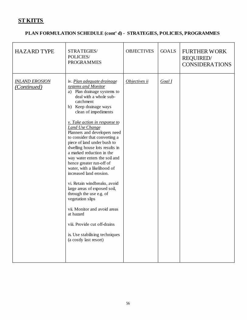
56
ST KITTS
PLAN FORMULATION SCHEDULE (cont’d) - STRATEGIES, POLICIES, PROGRAMMES
HAZARD TYPE STRATEGIES/POLICIES/PROGRAMMES
OBJECTIVES GOALS FURTHER WORKREQUIRED/CONSIDERATIONS
INLAND EROSION(Continued)
iv. Plan adequate drainagesystems and Monitora) Plan drainage systems to
deal with a whole sub-catchment
b) Keep drainage waysclean of impediments
v. Take action in response toLand Use ChangePlanners and developers needto consider that converting apiece of land under bush todwelling house lots results ina marked reduction in theway water enters the soil andhence greater run-off ofwater, with a likelihood ofincreased land erosion.
vi. Retain windbreaks, avoidlarge areas of exposed soil,through the use e.g. ofvegetation slips
vii. Monitor and avoid areasat hazard
viii. Provide cut off-drains
ix. Use stabilising techniques(a costly last resort)
Objectives ii Goal I
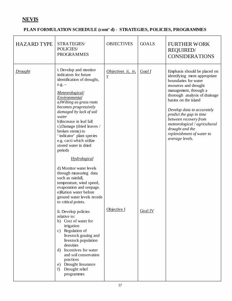
57
NEVIS
PLAN FORMULATION SCHEDULE (cont’d) - STRATEGIES, POLICIES, PROGRAMMES
HAZARD TYPE STRATEGIES/POLICIES/PROGRAMMES
OBJECTIVES GOALS FURTHER WORKREQUIRED/CONSIDERATIONS
Drought i. Develop and monitorindicators for futureidentification of drought,e.g. –
Meteorological/Environmentala)Wilting as grass rootsbecomes progressivelydamaged by lack of soilwaterb)Increase in leaf fallc).Damage (dried leaves /broken stems) to‘indicator’ plant speciese.g. cacti which utilizestored water in driedperiods
Hydrological
d) Monitor water levelsthrough measuring datasuch as rainfall,temperature, wind speed,evaporation and seepage.e)Ration water beforeground water levels recedeto critical points.
Ii. Develop policiesrelative to:b) Cost of water for
irrigationc) Regulation of
livestock grazing andlivestock populationdensities
d) Incentives for waterand soil conservationpractices
e) Drought Insurancef) Drought relief
programmes
Objectives ii, iv,v
Objective I
Goal I
Goal IV
Emphasis should be placed onidentifying more appropriateboundaries for waterresources and droughtmanagement, through athorough analysis of drainagebasins on the island
Develop data to accuratelypredict the gap in timebetween recovery frommeteorological / agriculturaldrought and thereplenishment of water toaverage levels.
58
SECTION V – PHASING AND IMPLEMENTATION
5.1 Phasing
The Plan identifies Strategies, Policies and Programmes for the next ten years, andwould be subject to review within at least the next five years.
It is anticipated that the respective Government Ministries would develop projectsbased on the foregoing Strategies, Policies and Programmes, taking into accountappropriate phasing periods.
5.1.1 Immediate Next Steps
A number of Strategies, Policies and Programmes have been presented for facilitatingdisaster mitigation. Specific projects would need to be identified towards a phasedimplementation of The Plan. The way forward for implementation of The Planrequires an orderly approach which may be executed in the steps listed below. It isnoted that some of these steps may be carried out concurrently. The next steps maybe summarised as follows:-
1. Present The Plan to all Government Departments/Agencies.2. Publicise The Plan.3. Prioritise the strategies, policies and programmes to be undertaken. The
National Disaster Mitigation Council which includes representation from allGovernment Departments/Agencies would need to set the priorities.
4. Identify projects to be carried out based on the prioritised strategies, policiesand programmes.
5. Prioritise the projects identified.6. Identify the resources (human and material) and other requirements (e.g
additional studies/research to be undertaken) which would be required forexecution of the project.
7. Identify the Government Departments/Agencies which have responsibilityfor implementation of specific projects.
8. Identify the projects which would require collaboration amongDepartments/Agencies, and specify those Departments/Agencies.
9. Agree on an approach/system for facilitating collaboration among agenciesspecified in #8, above.
10. For each project, agree on a time-frame for expected commencement andcompletion of that project.
11. Identify milestones for ensuring that the project is on track..12. Develop a ‘Phased Implementation Schedule’ based on the aforementioned.

59
5.2 Responsibility for Implementation
Responsibility for implementation of The Plan rests with the GovernmentDepartments/Agencies. In instances where (mitigation) projects are undertaken by theprivate sector, or where there is private sector joint participation, the GovernmentDepartment/Agency under whose umbrella such activities fall, would be responsiblefor enabling and monitoring the implementation of that project.
It is therefore necessary for the various Departments/Agencies to schedule executionof the identified project(s) and related activities within the annual work programmeand to obtain budgetary allocations for such projects.
SECTION VI – EVALUATION, MONITORING AND UPDATING
The National Emergency Management Agency under the guidance of the NationalManagement Advisory Council is responsible for monitoring implementation of ThePlan. Accordingly, a mitigation officer should be appointed to assist with suchmonitoring.
In order to keep the Plan current and relevant to the needs of St Kitts and Nevis,periodic review and evaluation of the implementation of the Plan with respect to -Strategies, Policies, Programmes and the related projects would be required.
A periodic reporting system should be instituted for –
a) advising the National Disaster Mitigation Council on the status of theimplementation of The Plan, and
b) making recommendations for keeping The Plan up to date.

60
REFERENCES
BENDER O STEPHEN, 1986 Report on Natural Hazards and SettlementDevelopment Planning in St Kitts and Nevis.OAS/DRD St Kitts and Nevis ForestryDevelopment and Resource ManagementPlanning Project.
BENTLEY ASSOCIATES (1998) Plan To Reduce The Vulnerability Of SchoolBuildings To Natural Hazards in St Kitts.Organisation of American States/ UnitedStates Agency for International Development/European Community Humanitarian Office
COOPER V. (2001) Flood Hazard Mapping St.Kitts & Nevis
DANIEL EDSEL B.(2001) An Assessment of Coastal Erosion Hazards inSt. Kitts and Nevis
ISLAND RESOURCES FOUNDATION Country Environmental Profile: St.Kitts andNevis
JACKSON IVOR (2001) Nevis Drought Hazard Assessment andMapping Summary Report
LANG DAVID (2001) St Kitts Inland Erosion Report Assessment,Mapping, and Mitigation Summary Report
MATTENET EDUARDO M. LICE Report - Hazard Vulnerability Assessment(2001) St. Kitts and Nevis
NATIONAL EMERGENCY MANAGE-MENT AGENCY (NEMA) Hazard Vulnerability: An Assessment of the
Housing Sector in St Kitts
NELSON L CARL (1989) Protecting the Past from Natural DisastersNational Trust for Historic Preservation
61
NEVIS ISLAND ADMINISTRATION An Environmental Assessment of Nevis:(1995) Post Hurricane Luis (Highlight on Western
Coast)
PHYSICAL PLANNING DIVISION Hazard Mitigation and Post-StormST KITTS (1999) Redevelopment Policies
ROGERS T CASSANDRA PH.D.ATWELL LYNETTE, B.A. Workshop Guide – Post-Georges Disaster Dip. Town and Regional Planning Mitigation Project, Implemented by the
Organisation of American States Unit ofSustainable Development and Environment forUSAID- Jamaica/Caribbean RegionalProgramme
Workshop Report – June 13 to 15, 2000
ROGERS T CASSANDRA, PHD Workshop Report – September 13 to 14, 2000
WAGENSEIL R. (2001) Wind and Storm Surge Technical Report