Embed Size (px)
Citation preview

MSP/EMHSD Pub. 106a MAY 2011
EMERGENCY MANAGEMENT AND HOMELAND SECURITY DIVISION
Michigan Department of State Police
Michigan Hazard Mitigation Success Stories
Outstanding accomplishments in reducing loss of life, property and environmental damage associated with hazards in Michigan
Prepared by:
Emergency Management and Homeland Security Division Michigan Department of State Police
And
The Michigan Citizen-Community Emergency Response Coordinating Council

This document was prepared under a grant from FEMA’s Grant Programs Directorate, U.S. Department of Homeland Security. Points of view or opinions expressed in this document are those of the authors and do not necessarily represent the official position or policies of FEMA’s Grant Programs Directorate or the U.S. Department of Homeland Security.
MSP/EMHSD Hazard Mitigation Contacts: Matt Schnepp , State Hazard Mitigation Officer, MSP/EMHSD: Phone – (517) 336-2040; E-Mail – [email protected] Joel Pepper , Assistant State Hazard Mitigation Officer, MSP/EMHSD: Phone – (517) 336-2039; E-Mail – [email protected] Mike Sobocinski , Hazard Mitigation Planning Specialist, MSP/EMHSD: Phone – (517) 336-2053; E-Mail – [email protected] Mitch Graham , Hazard Mitigation Planning Specialist, MSP/EMHSD: Phone – (517) 333-5022; E-Mail – [email protected] Doran Duckworth , State Support Unit Manager, MSP/EMHSD: Phone – (517) 333-5045; E-Mail – [email protected] Jim Porcello , Planning and Program Development Section Manager, MSP/EMHSD: Phone (517) 336-6435; E-Mail – [email protected]
Hazard Mitigation Assistance in Action: Recent Examples of Successful Mitigation Projects
Photos L-R: Culvert upgrade project in Rose City, Michigan. (The project involved the removal of inadequately sized culverts and replacement with a single, appropriately sized box culvert to prevent area flooding.) Standby power source project in the City of Alpena, Michigan. (The project involved the installation of an emergency generator at the city’s wastewater treatment plant so that raw sewage will not back-up into basements in the event of a power outage.) Culvert upgrade project in Iosco County. (The project involved the removal of two inadequately sized culverts and replacement with a single, appropriately sized culvert, and enlargement of the drainage ditch to prevent the roadway from flooding and septic systems in the area from failing.)

Michigan Hazard Mitigation Success Stories
TABLE OF CONTENTS Introduction Letter from MCCERCC Chair Acronyms Used in this Document
Hazard Mitigation Primer: Basic Principles and Practices Introduction to Hazard Mitigation ........................................................................................................................................1
What is Hazard Mitigation?.........................................................................................................................................1 State Government Role ..............................................................................................................................................1 Local Government Role ..............................................................................................................................................1 Hazard Mitigation: National Perspective and Federal Government Role....................................................................1 Hazard Mitigation Makes Financial Sense..................................................................................................................1 Coordination of Ongoing Efforts .................................................................................................................................2
State-Level Hazard Mitigation Coordination .......................................................................................................................2 1998-2007: Michigan Hazard Mitigation Coordinating Council ...................................................................................2 2007-Present: Michigan Citizen-Community Emergency Response Coordinating Council........................................3 MCCERCC Hazard Mitigation Responsibilities...........................................................................................................3 MCCERCC Provides Many Benefits...........................................................................................................................4
Mitigation: Unlocking the Disaster Equation .......................................................................................................................4 Corrective and Preventive Mitigation ..................................................................................................................................4 Management of Federal Hazard Mitigation Assistance ......................................................................................................5
Table 1 – Basic Hazard Mitigation Strategies .............................................................................................................6 Table 2 – Hazard Mitigation Assistance: Program Descriptions.................................................................................7 Hazard Mitigation Assistance Grants Create Mitigation Success Stories...................................................................8 Table 3 – Summary of Hazard Mitigation Grant Programs in Michigan: 1994-2009 ..................................................8 Table 4 – Summary of Hazard Mitigation Grant Programs in Michigan: Project Type / Federal Share Expenditure (1994-2009) ............................................................................................................................................8 Table 5 – Summary of Hazard Mitigation Grant Programs in Michigan: Project Type by Program............................9
Selected Hazard Mitigation Success Stories: 1998-2011
City of Vassar Flood Mitigation Plan.................................................................................................................................11 Tuscola County / City of Vassar Flood Drainage Improvements......................................................................................12 Ottawa County / Robinson Township Flood Mitigation Planning and Flood-Prone Properties Acquisition.......................13 Flint River Dike Flood Control...........................................................................................................................................15 Local Hazard Mitigation Plan Development in Michigan...................................................................................................16 Hazard Mitigation Success Stories from May-June 2004 Storms and Flooding (Federal Disaster 1527-DR-MI) ........................................................................................................................................20 Genesee County / City of Grand Blanc Flood-Prone Properties Acquisition ....................................................................21 “Storm Rooms” at Michigan State University Child Care Center ......................................................................................22 Wayne County Early Warning Enhancements .................................................................................................................23 Urban Forestry Disaster Management Educational Outreach..........................................................................................24 Oakland County Stream Bank Stabilization......................................................................................................................25 Muskegon County / City of Montague Flood-Prone Property Acquisition .........................................................................26 Michigan Hazard Mitigation Coordinating Council: 1998-2007 .........................................................................................27 Marquette County Roadway Restructuring .......................................................................................................................28 Livingston County / Putnam Township Flood-Prone Properties Acquisition.....................................................................28 Charlevoix County Overpass Culvert Restructuring .........................................................................................................29 Barry County Hazard Mitigation Plan Development Process............................................................................................30 Bay County Stormwater Flood Mitigation Improvements..................................................................................................31 Newaygo County / Bridgeton Township Flood-Prone Home Elevation.............................................................................32 Wayne County / City of Wyandotte Restricted Flow Catch Basin Covers ........................................................................33 Monroe County / Village of Estral Beach Flood-Prone Home Elevations .........................................................................34 Gratiot County Culvert Replacement ................................................................................................................................36 Marquette County Hazardous Dam Removal ...................................................................................................................36 Innovative Stormwater Floodplain Simulation Model........................................................................................................38 Lake / Mason / Osceola County NOAA Weather Early Warning Enhancement...............................................................40

Oakland County / Waterford Township Cross-Connection Elimination Program .............................................................40 Leelanau County Mass Gathering Ordinance...................................................................................................................42 Michigan’s “Project Impact” Communities ........................................................................................................................43 Michigan Hazard Mitigation Plan Certified Under Federal Disaster Mitigation Act of 2000 ..............................................44 Michigan Emergency Alert System Enhancements..........................................................................................................46 Wildfire Prevention in Southern Michigan.........................................................................................................................49 St. Clair County / City of Port Huron Standby Power Source for Water Treatment Plant.................................................50 Construction of School Buildings Act Amendment ...........................................................................................................51 Integration of Hazard Mitigation Functions into the Michigan Emergency Management Plan..........................................52 Underground Storm Shelters for the Grand Traverse Band of Ottawa and Chippewa Indians ........................................53 Smoke Alarm Acts ............................................................................................................................................................54 Innovative Hazard Analysis and Mapping Techniques in Allegan County ........................................................................55 Local Hazard Mitigation Planning in the West Michigan Shoreline Region ......................................................................56 Sebewaing River Emergency Floodway ...........................................................................................................................56 Washtenaw County / City of Ann Arbor Integrated Hazard Mitigation Planning ...............................................................57 Integration of Hazard Mitigation into Comprehensive Planning........................................................................................59 Attachment: Presidential and Gubernatorial Emergency / Disaster Declarations in Michigan .........................................61 For additional information on state, local and tribal government hazard mitigation activities in Michigan please refer to the Michigan Hazard Mitigation Plan, MSP/EMHSD Publication 106, dated March 2011. The cover of that document is pictured below.


THIS PAGE INTENTIONALLY LEFT BLANK.
Acronyms Used in this Document
CDBG ................................................................................................................................................................Community Development Block Grant CDM.......................................................................................................................................................................................Camp, Dresser & McKee CF......................................................................................................................................................................................................... Compact Flash CUPPAD..................................................................................................................................... Central Upper Peninsula Planning and Development DMA or DMA 2000 ........................................................................................................................................................ Disaster Mitigation Act of 2000 DR.................................................................................................................................................................................................... Disaster Recovery EAS ....................................................................................................................................................................................... Emergency Alert System EM .........................................................................................................................................................................................Emergency Management EMAP.................................................................................................................................................Emergency Management Accreditation Program EMS.................................................................................................................................................................................. Emergency Medical Service EOC.............................................................................................................................................................................. Emergency Operations Center ESF................................................................................................................................................................................. Emergency Support Function FEMA........................................................................................................................................................... Federal Emergency Management Agency FMA ................................................................................................................................................................................ Fire Management Assistance FMAP.................................................................................................................................................................. Flood Mitigation Assistance Program FIRM....................................................................................................................................................................................Flood Insurance Rate Map GIS ............................................................................................................................................................................. Geographic Information System HMA.................................................................................................................................................................................Hazard Mitigation Assistance HMGP ....................................................................................................................................................................... Hazard Mitigation Grant Program HS................................................................................................................................................................................................... Homeland Security ICS..................................................................................................................................................................................... Incident Command System LP ..................................................................................................................................................................................... Local Primary (EAS Station) MAB................................................................................................................................................................... Michigan Association of Broadcasters MCCERCC..................................................................................................Michigan Citizen-Community Emergency Response Coordinating Council MDCIS ..............................................................................................................................Michigan Department of Consumer and Industry Services** MDELEG.................................................................................................................... Michigan Department of Energy, Labor and Economic Growth** MDNR ................................................................................................................................................... Michigan Department of Natural Resources*** MDNRE......................................................................................................................Michigan Department of Natural Resources and Environment*** MDOT ..............................................................................................................................................................Michigan Department of Transportation MEMP .............................................................................................................................................................Michigan Emergency Management Plan MHMCC ............................................................................................................................................Michigan Hazard Mitigation Coordinating Council MHMP.........................................................................................................................................................................Michigan Hazard Mitigation Plan MI....................................................................................................................................................................................................................Michigan MSP/EMHSD ............................................................................... Michigan State Police / Emergency Management and Homeland Security Division* MSU...................................................................................................................................................................................... Michigan State University MSUE ...................................................................................................................................................................Michigan State University Extension NFIP........................................................................................................................................................................ National Flood Insurance Program NIBS ..................................................................................................................................................................National Institute of Building Sciences NIMS................................................................................................................................................................ National Incident Management System NOAA.............................................................................................................................................. National Oceanic and Atmospheric Administration NRP ........................................................................................................................................................................................ National Response Plan PA..................................................................................................................................................................................................... Public Assistance PA....................................................................................................................... Public Act (when used in Michigan legal citation, e.g., 1976 PA 390) PDA ..........................................................................................................................................................................Preliminary Damage Assessment PDMP .........................................................................................................................................................................Pre-Disaster Mitigation Program RFCP........................................................................................................................................................................ Repetitive Flood Claims Program RPO....................................................................................................................................................................................... Regional Planning Office SAP ....................................................................................................................................................................................... Separate Audio Program SBA .................................................................................................................................................................... (U.S.) Small Business Administration SEOC................................................................................................................................................................... State Emergency Operations Center SRLP ......................................................................................................................................................................... Severe Repetitive Loss Program WMSRDC .....................................................................................................................West Michigan Shoreline Regional Development Commission
Explanatory Notes Regarding Department / Agency Name Changes:
*The Emergency Management and Homeland Security Division of the Michigan Department of State Police (MSP/EMHSD) was named the Emergency Management Division of the Michigan Department of State Police (MSP/EMD) from 1982 to early 2006. Effective March 1, 2006, the name of the Emergency Management Division was officially changed to the Emergency Management and Homeland Security Division, reflecting the division’s broader scope of responsibilities related to homeland security. Even though some of the success stories contained in this document cover a period of time before that name change occurred, for clarity purposes the name Emergency Management and Homeland Security Division and acronym MSP/EMHSD are used throughout the document. Although this is not historically correct in some instances, it is necessary to prevent confusion caused by using two different names and acronyms. **The Michigan Department of Consumer and Industry Services (MDCIS) became the Michigan Department of Labor and Economic Growth (MDLEG) and then later the Michigan Department of Energy, Labor and Economic Growth (MDELEG). The MDELEG was renamed the Michigan Department of Licensing and Regulatory Affairs (MDLRA) in 2011. ***The Michigan Department of Natural Resources (MDNR) name was changed effective January 17, 2010, per Executive Order 2009-45, to the Michigan Department of Natural Resources and Environment (MDNRE). However, the name was changed back to the Michigan Department of Natural Resources effective March 13, 2011, per Executive Order 2011-1.

THIS PAGE INTENTIONALLY LEFT BLANK.

Michigan Hazard Mitigation Success Stories – May 2011
1
Hazard Mitigation Primer: Basic Principles and Practices
Introduction to Hazard Mitigation
What is Hazard Mitigation? Hazard mitigation is defined as any action taken before, during or after a disaster or emergency to permanently eliminate or reduce the long-term risk to human life and property from natural, technological and human-related hazards. It is an essential element of emergency management, along with preparedness, response and recovery. When successful, mitigation will lessen the need for a community to respond to succeeding hazard events; that is, incidents will remain incidents and not become disasters. State Government Role Hazard mitigation strives to reduce the impact of hazards on people and property through the coordination of resources, programs, initiatives and authorities. State government has a vital coordinating role to play in this effort. Laws and processes governing the use of land and development of property originate at the state level. In addition, state agencies administer a wide variety of programs that affect – either directly or indirectly – the development and use of land. For these reasons, state government is the logical level of origination for hazard mitigation measures that have statewide application and/or implications. Local Government Role The implementation of hazard mitigation measures is inherently a local government function since that is the level at which development occurs, and most of the land use / development tools available to implement mitigation measures are applied at the local level. Therefore, successful implementation of a program to reduce or eliminate the negative consequences of Michigan’s hazards will, out of necessity, be a joint cooperative effort between the State, local governments, and the private sector (since most land development is undertaken by private entities). Hazard Mitigation: National Perspective and Federal Government Role Nationally, hazard mitigation is at a crossroads. Recent catastrophic disasters across the United States have resulted in unparalleled devastation, suffering and economic loss. These events have highlighted the fact that the U.S. continues to be on a collision course with our natural environment. Increased development in hazard prone areas has put an ever-increasing number of people and structures in harm’s way, greatly exacerbating the negative consequences associated with our risk and vulnerability to natural, technological and human-related hazards. As a result, when disasters occur they increasingly cause tremendous economic, social and physical losses to the communities and people they affect. Fortunately, efforts are underway to reverse (or at least slow down) this trend. In recent years, the art and science of hazard mitigation has evolved into a national and even international effort. The National Mitigation Strategy, National Pre-Disaster Mitigation Plan, National Flood Insurance Program (NFIP), Flood Mitigation Assistance Program (FMAP), Hazard Mitigation Grant Program (HMGP), “Project Impact” initiative, Pre-Disaster Mitigation Program (PDMP), Repetitive Flood Claims Program (RFCP), Severe Repetitive Loss Program (SRLP), and the Disaster Mitigation Act (DMA) of 2000 are the most prominent of the federal government’s recent efforts to reduce or eliminate the nation’s risk and vulnerability to hazards. The Federal Emergency Management Agency (FEMA) is spearheading these and many other similar efforts, in partnership with federal agencies, Congress, states, local governments, academia, the private sector and individual citizens. Hazard Mitigation Makes Financial Sense FEMA invests millions annually in hazard mitigation programs. With the general belief that mitigation saves money but with limited hard evidence as to the magnitude of the long-term benefits, Congress mandated that FEMA commission an independent study to ensure that its investments are paying off. The study, which was conducted by the Applied Technology Council and overseen by the Multi-Hazard Mitigation Council of the National Institute of Building Sciences (NIBS), began in 2000 and was delivered to Congress in December 2005.

Michigan Hazard Mitigation Success Stories – May 2011
2
The NIBS study results are impressive and overwhelmingly demonstrate that hazard mitigation is worth the investment. On average, the study found that hazard mitigation activities pay off to the tune of $4 of savings for every $1 invested. The study quantified future savings from mitigation activities related to natural hazards. The activities assessed in the study were funded through three FEMA mitigation programs (i.e., the Hazard Mitigation Grant Program, “Project Impact,” and Flood Mitigation Assistance Program). Eight communities from across the country that have participated in the FEMA grant programs since 1988 were studied. The community studies looked at direct benefits from the projects as well as “synergistic activities – other mitigation efforts that would not have occurred had it not been for the original FEMA grant.” The benefits considered in the report included reduced property damage, reduced business interruption, reduced environmental damage, reduced human losses (deaths, injuries, homelessness, etc.), and reduced costs for emergency response. Background Note: An interesting aspect about the NIBS study is that it has Michigan ties. Tuscola County was one of the eight communities studied. Tuscola County has been subjected to significant flooding over the years, and because of that flood history has made a concerted effort to mitigate flood damages. Tuscola County received four HMGP grants between 1998 and 2004 that were reviewed as part of the study. One of the projects developed with one of those grants, flood drainage improvements in the City of Vassar, is featured as a mitigation success story in this compendium document.
Coordination of Ongoing Efforts Coordination is probably the most critical factor in a successful mitigation effort or program. Many state and local agencies (as well as some private sector organizations) are already performing functions or administering programs that in some way contribute to mitigating hazards. Examples of existing, ongoing activities that promote or can contribute to hazard mitigation include but are not limited to: • Capital improvements planning • Budgeting • Site-specific hazardous material emergency planning (through Local Emergency Planning Committees) • Watershed management planning • Solid waste management planning • Local community planning and zoning activities • Building / construction codes and development standards • Regional planning • Transportation planning • Recreation planning • Forest management • Coastal zone management • Infrastructure design, regulation and permitting • Floodplain management • Public facility design and construction review Unfortunately, coordination of these programs and activities for the purpose of achieving widespread hazard risk and vulnerability reduction is often limited, if it occurs at all.
State-Level Hazard Mitigation Coordination
1998-2007: Michigan Hazard Mitigation Coordinating Council For many years, the lack of a central focus and coordinating element for hazard mitigation in Michigan hampered the development of an effective statewide program of hazard risk and vulnerability reduction. In response to that problem, Governor John Engler signed Executive Order 1998-5 on July 29, 1998, creating the Michigan Hazard Mitigation Coordinating Council (MHMCC) to fill the void of hazard mitigation coordination at the state level. The MHMCC existed for nine years and officially met a total of 31 times. The MHMCC had many noteworthy accomplishments, the most prominent of which included: • Selection of over 160 mitigation projects, totaling in excess of $45 million in project costs, for four federal hazard
mitigation grant programs. This included projects related to three federally-declared major disasters under the Robert T. Stafford Disaster Relief and Emergency Assistance Act (Stafford Act), Public Law 93-288, as amended.

Michigan Hazard Mitigation Success Stories – May 2011
3
• Assisting in the development of Michigan Executive Directive 2001-5 (State Flood Hazard Mitigation), signed by
Governor John Engler on September 11, 2001. • Assisting in the development of the initial Michigan Hazard Mitigation Plan in 2004 (certified as federal Disaster
Mitigation Act of 2000 compliant on March 23, 2005). • Assisting in the development of Michigan’s “Most Wanted Hazard Mitigation Measures” list as a component
element of the Council’s Annual Report of Activities to the Governor and Michigan Legislature. • Assisting in the development of post-incident Hazard Mitigation Strategies for three federally-declared major
disasters (1346-DR-MI; 1413-DR-MI; and 1527-DR-MI). • Selection / coordination of four “Project Impact” communities in Michigan (City of Midland – 1998; Ottawa County –
1999; City of Dearborn – 2000; and Ingham County – 2001) as part of the federal Project Impact Initiative that existed from 1997 to 2002.
• Assisting in the development of a statewide repetitive flood loss reduction project (a pilot effort is currently ongoing in the Village of Estral Beach, Monroe County).
• Assisting in the development of a statewide local mitigation planning project to develop and maintain plans covering all 83 counties (currently ongoing).
• Assisting in the development of a statewide hazard mitigation marketing and education campaign for seven targeted professional groups (currently ongoing).
2007-Present: Michigan Citizen-Community Emergency Response Coordinating Council On May 2, 2007, the MHMCC was abolished by Governor Jennifer Granholm’s Executive Order 2007-18 and replaced by the new Michigan Citizen-Community Emergency Response Coordinating Council (MCCERCC). This new advisory body combines the MHMCC with the Michigan Citizen Corps Council and the Michigan Emergency Planning and Community Right-to-Know Commission (which were also abolished) to form a single entity chaired by the Department of State Police. The new Council is responsible for developing and implementing emergency response and hazard mitigation plans for the state. Executive Order 2007-18 transferred the MHMCC’s hazard mitigation responsibilities intact to the new MCCERCC. The MCCERCC membership was announced on August 29, 2007, and its first meeting was held on January 29, 2008. The MCCERCC is chaired by the Emergency Management and Homeland Security Division of the Michigan Department of State Police (MSP/EMHSD) and is composed of 19 representatives including the Directors of (or a designee) from the Michigan Departments of State Police, Agriculture, Community Health, Environmental Quality, Military and Veterans Affairs, and Transportation; the State Fire Marshal; the Executive Director of the Michigan Community Service Commission; plus 11 other representatives appointed by the Governor. Provisions in the Executive Order allow for the hiring or retention of contractors, subcontractors, advisors, consultants, and agents, as required when specific issues are addressed that require specialized expertise or technical knowledge. MCCERCC Hazard Mitigation Responsibilities Executive Order 2007-18 charges the MCCERCC with four primary hazard mitigation responsibilities: • Assisting in the development, maintenance and implementation of a state hazard mitigation plan. • Assisting in the development, maintenance and implementation of guidance and informational materials to support
hazard mitigation efforts of local and state government and private entities. • Soliciting, reviewing and identifying hazard mitigation projects for funding including but not limited to, federal
funding under Section 404 of the Robert T. Stafford Disaster Relief and Emergency Assistance Act, 42 USC 5170c, and Sections 553 and 554 of the National Flood Insurance Reform Act of 1994, 42 USC 4104c and 42 USC 4014d.
• Fostering and promoting, where appropriate, hazard mitigation principles and practices within local and state government and with the general public.
The MCCERCC has three standing committees: Hazard Mitigation; Citizen Corps; and Emergency Planning and Community Right-to-Know. The Hazard Mitigation Committee oversees and carries out the Council’s four hazard mitigation responsibilities. One of the MCCERCC’s primary roles is to support and promote hazard mitigation concepts, principles, strategies and practices within governmental agencies and private sector organizations in Michigan. This can be accomplished in a variety of ways including but not limited to: • Amendments to laws, rules, regulations, plans, and procedures • Changes in governmental and business practices and processes • Public education and awareness campaigns

Michigan Hazard Mitigation Success Stories – May 2011
4
• Coordination of programs, information, initiatives and resources • Development of structural and non-structural projects to mitigate location-specific hazard vulnerabilities • Establishment of collaborative public / private partnerships to identify, develop and implement specific mitigation
opportunities for local, regional or statewide application MCCERCC Provides Many Benefits The primary advantage of the MCCERCC is that it fosters improved coordination of ideas, expertise, talent, programs, laws, rules and regulations, philosophies, and material resources. Such coordination manifests itself in many ways including but not limited to: • Better and faster delivery of hazard mitigation programs and services (during disaster and non-disaster times) • Less overlap and duplication of actions and activities • Improved information flow among departments / agencies and levels of government, and between public and
private entities • Development and implementation of multi-objective projects with fewer resources expended • Greater understanding of mitigation issues and concerns (issues are addressed by multiple agencies with multiple
perspectives) • Greater cost savings to the taxpayers due to reduced future damages from disasters, reduced response and
recovery costs, and the preceding reasons listed above The MCCERCC provides the structure and coordination mechanism necessary to bring together the many disparate yet interrelated programs and activities that affect Michigan’s ability to achieve an effective, meaningful hazard risk and vulnerability reduction strategy for the state.
Mitigation: Unlocking the Disaster Equation Perhaps the best way to understand hazard mitigation is to first understand the nature of disasters themselves. The basic equation for a disaster is simple: Hazards + People and Structures = Disaster. Disasters only occur because people and structures are in harm’s way. The key to preventing or limiting disaster damage and impact is to unlock and separate the key components of this equation. Controlling the hazard is often difficult if not impossible (a tornado is a good example), but there are situations in which the hazard can be effectively controlled. (See Strategy 1, Modification of the Hazard, in the table on page 6.) Modifying the other part of the equation – the people and structures – is in most cases easier and more effective in reducing or eliminating the negative consequences of hazards because these elements are more closely under our control. (See Strategies 2-4 in the table on page 6.) However, even that can be a daunting proposition at times given our desire to live near water, in the woods, on hillsides or in valleys, or near / in other hazard-prone areas. Table 1 on page 6 provides an overview of the five basic hazard mitigation strategies that can be utilized to reduce or prevent the harmful interaction between hazards, people and development that results in a disaster. For each strategy, examples are provided of specific mitigation measures that can be employed to correct past practices that have increased hazard vulnerability (“corrective mitigation”) and/or to prevent future problems from occurring in the first place (“preventive mitigation”) through proactive public education, wise decision-making and disaster-resistant building and development practices.
Corrective and Preventive Mitigation The five hazard mitigation strategies can be grouped into two broad categories of work: 1) corrective mitigation – correcting past practices that have increased hazard vulnerability; and 2) preventive mitigation – preventing future problems from occurring in the first place through public education, wise decision-making and disaster-resistant building and development practices. Corrective mitigation can be expensive, resource intensive, time consuming and sometimes only marginally effective. Structural protection measures, hazard modification and large-scale retrofitting fall under this category. Attempting to go back and fix something that is problematic is almost always more difficult than doing it right the first time. However, when dealing with hazard prone property (e.g., non-mitigated “legacy” development in a floodway, floodplain or other hazard area), it is often necessary to go back and try to correct the problem in order to protect the affected community and individual property owners from future harm. Corrective mitigation measures also help reduce future response and recovery costs by reducing community vulnerability to hazards.

Michigan Hazard Mitigation Success Stories – May 2011
5
Preventive mitigation is desirable because it seeks to prevent future problems from occurring in the first place. Wise land use planning, building design and construction practices, small-scale retrofitting, and early warning and public education fall under this category. When it comes to reducing the negative consequences of hazards on a community, the old adage “an ounce of prevention is worth a pound of cure” certainly rings true. (Or, perhaps it is more realistic to say “a dollar’s worth of mitigation is worth four dollars of recovery” in recognition of the 2005 National Institute of Building Sciences study on the value of mitigation.) Doing something right the first time is almost always preferable to going back and trying to correct recurring problems at a later date. To create and maintain safe, sustainable communities, both preventive and corrective mitigation must occur at the state and local levels. An example of preventive mitigation at the local level would be a policy requiring that all future development occur in such a way as to avoid or reduce, to the extent possible, community exposure and vulnerability to hazards. That would prevent the scope and magnitude of the problem from increasing. Corrective mitigation measures could be applied in those areas that have a high degree of exposure and vulnerability to certain hazards and that suffer severe and/or repetitive damage as a result (thus correcting current problems caused by unwise and/or outdated land development patterns and building practices).
Management of Federal Hazard Mitigation Assistance The State of Michigan, through the MSP/EMHSD, provides “cradle to grave” (from initial grant application development to final closeout) management of five federal hazard mitigation grant programs and is responsible for issuing all grant agreements as well as disbursing grant funding to eligible governmental and nongovernmental applicants. The five programs are: • Hazard Mitigation Grant Program (HMGP) • Pre-Disaster Mitigation Program (PDMP) • Flood Mitigation Assistance Program (FMAP) • Repetitive Flood Claims Program (RFCP) • Severe Repetitive Loss Program (SRLP) The PDMP, FMAP, RFCP and SRLP are annual, pre-disaster grant programs, while the HMGP is only implemented subsequent to a federal major disaster declaration under the Robert T. Stafford Disaster Relief and Emergency Assistance Act (Stafford Act), Public Law 93-288, as amended. Collectively, these five federal grant programs are referred to as “Hazard Mitigation Assistance” or “HMA.” Table 2 on page 7 provides summaries of the major provisions of each program.
THE REMAINDER OF THIS PAGE INTENTIONALLY LEFT BLANK.

Michigan Hazard Mitigation Success Stories – May 2011
6
Table 1 – Basic Hazard Mitigation Strategies
Mitigation Strategy Description Examples of Measures Advantages / Limitations Photo Example
1 – MODIFYING THE HAZARD
Modifying the hazard itself, which involves removing or eliminating the hazard, reducing its size or amount, or controlling the rate of release of the hazard. In the right circumstances, this strategy can be successful but it is often difficult to do.
• Cloud seeding to modify precipitation • Slope planting to prevent erosion or
collapse • Stream modification or widening to
divert or improve water flow • Dredging to deepen water channel or
body to improve water flow and capacity
• Can be cost-effective in many situations
• Application is limited and therefore may not be as effective as other strategies
• Does not always reduce or eliminate damage on a wide scale
• Some hazards simply cannot be modified
2 – SEGREGATING THE HAZARD
Attempts to “keep the hazard away from people.” Primarily for flood hazards but also has applicability to other hazards. Measures are designed to redirect the impacts of a hazard away from people and development.
• Dams • Dikes / Levees • Floodwalls • Flood drainage channels • Debris basins • Designated routes for hazardous
transport • Buffer zones around hazard sites • Defensible space around development • Safe rooms (indoor shelter space) to
protect building occupants from harm
• Can be effective for some hazard situations
• Some measures can be expensive • Some measures may cause or
exacerbate environmental problems • May protect one community but cause
problems for adjacent communities • Economically marginal for many
situations and locations
3 – PREVENTING OR LIMITING DEVELOPMENT
Preventing or limiting development in locations where people and development would be at risk. This strategy is based on “keeping the people away from the hazard” and includes a variety of land use planning and development regulation tools. Attempts to reduce or eliminate community hazard vulnerability through wise and prudent land use and development decision-making.
• Comprehensive planning • Zoning ordinances • Building codes • Subdivision regulations • Floodplain management ordinances
and other special area, use and design regulations
• Capital improvements planning • Disclosure laws • Acquisition and relocation of hazard
prone properties
• Can be highly effective in promoting safe, sustainable development
• Widespread application (i.e., statewide, regional, local)
• Proactive – seeks to prevent or reduce future vulnerabilities
• Reduces future incident response / recovery costs
• Administrative tools have minimal associated costs
• May in some cases reduce future tax revenue if development does not occur
4 – ALTERING DESIGN OR CONSTRUCTION
Altering the design or construction of development to make it less vulnerable (more resilient) to disaster damage. This strategy allows hazards to interact with human systems that have been designed and planned to withstand potentially destructive impacts. This strategy allows development in hazard prone areas, but requires that the development meet stringent disaster resistant performance criteria.
• Elevating flood-prone structures • Wet / dry flood proofing to improve
flood damage resistance • Defensible space (vegetation buffer
zones) in urban / wildland intermix areas
• Wind bracing to improve wind damage resistance
• Insulating water and sewer lines to prevent ground freeze damage
• Balances the dual needs of enhancing a community’s economic base while at the same time reducing community hazard vulnerability
• Can result in safe, sustainable development if done properly
• Reduces future incident response / recovery costs
• Allows for maximum land use potential • Resilient structures “rebound” better
from incident impacts
5 – EARLY WARNING AND PUBLIC EDUCATION
Seeks to ensure that the public is aware of the hazards it faces, and that proper warning and communication systems and practices are in place to save lives and protect property.
• Community hazard identification / analysis
• Early warning systems (indoor and outdoor)
• Tailored public awareness / education campaigns regarding hazards, warning systems and protective actions
• Warning devices in congregate facilities
• Special needs population warning systems
• Universal strategy – should be applied in all communities
• Typically the last line of defense against serious disaster related injury, loss of life and property damage
• Recognizes that some hazards cannot be prevented and therefore must be dealt with using proper safety precautions
• Enhances community awareness of and support for emergency management efforts

Michigan Hazard Mitigation Success Stories – May 2011
7
Table 2 – Hazard Mitigation Assistance: Program Descriptions
Program Description Authorization / Eligibility* Eligible Activities Program Type / Cost Share
HAZARD MITIGATION GRANT PROGRAM (HMGP)
HMGP grants are provided to implement long-term hazard mitigation measures after a major disaster declaration. The purpose of the HMGP is to reduce the loss of life and property due to natural disasters and to enable mitigation measures to be implemented during the immediate recovery from a disaster.
Section 404 of the Robert T. Stafford Disaster Relief and Emergency Assistance Act, as amended (the Stafford Act), Title 42, USC 5170c Eligible Subapplicants: • State agencies • Tribal governments • Local governments • Private nonprofit organizations
• Property acquisition / structure demolition or relocation • Structure elevation • Dry floodproofing of historic residential structures • Dry floodproofing of non-residential structures • Minor localized flood reduction projects • Structural / non-structural retrofitting • Safe room construction • Infrastructure retrofitting • Soil stabilization • Wildfire mitigation • Post-disaster code enforcement • Hazard mitigation planning
Disaster Based (Stafford Act Major Disaster
Declaration Required)
75% Federal / 25% Non-Federal
PRE-DISASTER MITIGATION
PROGRAM (PDMP)
PDMP funds are provided for hazard mitigation planning and the implementation of mitigation projects prior to a disaster. Funding these plans and projects reduces overall risks to the population and structures from future hazard events, while also reducing reliance on federal funding from future major disaster declarations.
Section 203 of the Stafford Act, Title 42, USC 5133 Eligible Subapplicants: • State agencies • Tribal governments • Local governments • Universities
• Property acquisition / structure demolition or relocation • Structure elevation • Dry floodproofing of historic residential structures • Dry floodproofing of non-residential structures • Minor localized flood reduction projects • Structural / non-structural retrofitting • Safe room construction • Infrastructure retrofitting • Soil stabilization • Wildfire mitigation • Hazard mitigation planning
Annual Appropriation
75% Federal / 25% Non-Federal
90% Federal / 10% Non-Federal if subgrantee is a small
impoverished community
FLOOD MITIGATION ASSISTANCE
PROGRAM (FMAP)
FMAP funds are provided to implement measures that reduce or eliminate the long-term risk of flood damage to buildings, manufactured homes, and other structures insured under the National Flood Insurance Program (NFIP). The goal of the FMAP is to reduce or eliminate claims under the NFIP.
Section 1366 of the National Flood Insurance Act of 1968, as amended, Title 42, USC 4104c Eligible Subapplicants: • State agencies • Tribal governments • Local governments
• Property acquisition / structure demolition or relocation • Structure elevation • Dry floodproofing of historic residential structures • Dry floodproofing of non-residential structures • Minor localized flood reduction projects • Hazard mitigation planning
Annual Appropriation
75% Federal / 25% Non-Federal
REPETITIVE FLOOD CLAIMS PROGRAM
(RFCP)
RFCP funds are provided to reduce flood damages to insured properties that have had one or more claims under the National Flood Insurance Program (NFIP) and that will result in the greatest savings to the National Flood Insurance Fund (NFIF) in the shortest period of time. (Note: RFCP funds are only available to Subapplicants who cannot meet the cost share requirements of the FMAP.)
Section 1323 of the National Flood Insurance Act of 1968, as amended, Title 42, USC 4030 Eligible Subapplicants: • State agencies • Tribal governments • Local governments
• Property acquisition / structure demolition or relocation • Structure elevation • Dry floodproofing of historic residential structures • Dry floodproofing of non-residential structures • Minor localized flood reduction projects
Annual Appropriation
100% Federal
SEVERE REPETITIVE LOSS PROGRAM (SRLP)
SRLP funds are provided to reduce or eliminate the long-term risk of flood damage to severe repetitive loss (SRL) structures insured under the National Flood Insurance Program (NFIP), and that will result in the greatest amount of savings to the National Flood Insurance Fund (NFIF) in the shortest period of time.
Section 1361A of the National Flood Insurance Act of 1968, as amended, Title 42, USC 4102A Eligible Subapplicants: • State agencies • Tribal governments • Local governments
• Property acquisition / structure demolition or relocation • Structure elevation • Mitigation reconstruction • Dry floodproofing of historic residential structures • Minor localized flood reduction projects
Annual Appropriation
75% Federal / 25% Non-Federal
*States, Territories and Indian Tribal Governments are eligible HMA applicants. Interested and eligible subapplicants must apply to the applicant for HMA funding consideration. Individuals and businesses are not eligible to apply for HMA funds; however, an eligible subapplicant may apply for funding to mitigate private structures.

Michigan Hazard Mitigation Success Stories – May 2011
8
Hazard Mitigation Assistance Grants Create Mitigation Success Stories As the tables below and on the following page indicate, four of these grant programs have been used successfully in Michigan in recent years to fund a wide variety of mitigation projects aimed at permanently reducing or eliminating long-term risk to human life and property from hazards. These projects range from small, localized measures up to and including statewide initiatives. The mitigation success stories that follow these tables provide a snapshot of selected mitigation projects in Michigan funded under these grant programs. Although space will not allow each of the 310 projects to be highlighted, the ones that are featured provide excellent representative examples of how well thought out and designed measures can greatly reduce or eliminate the negative consequences of hazards on the implementing community:
Table 3 – Summary of Hazard Mitigation Grant Programs in Michigan: 1994-2009*
Program # of
Projects Total
Expenditure Federal Share Match Comments
HMGP (1028) 18 $ 1,134,648.08 $ 600,424.00 $ 534,224.08
HMGP (1128) 15 $ 2,672,704.99 $ 1,722,955.99 $ 949,749.00
HMGP (1181) 33 $ 5,245,124.56 $ 3,869,035.00 $ 1,376,089.56
HMGP (1226) 34 $ 3,602,800.73 $ 2,513,313.32 $ 1,089,487.41
HMGP (1237) 9 $ 737,277.15 $ 502,523.00 $ 234,754.15
HMGP (1346) 127 $ 28,182,540.00 $19,578,913.00 $ 8,603,627.00 Completed and/or closed out.
HMGP (1346) A 13 $ 6,420,192.00 $ 4,502,189.00 $ 1,918,003.00 Still active.
HMGP (1413) 8 $ 1,345,782.95 $ 738,776.94 $ 607,006.01
HMGP (1527) 11 $ 1,228,575.31 $ 906,692.44 $ 321,882.84 Completed and/or closed out.
HMGP (1527) A 1 $ 307,100.00 $ 230,325.00 $ 83,100.00 Still active.
FMAP 24 $ 805,778.83 $ 599,225.96 $ 206,552.87 This includes completed and active projects.
PDMP 16 $ 11,094,992.77 $ 8,221,877.40 $ 2,964,115.37 This includes completed and active projects.
RFCP 1 $ 180,018.00 $ 180,018.00 0
SRLP 0 0 0 0 Only 7 properties eligible statewide.
TOTALS: 310 $ 62,957,535.37 $44,166,269.05 $18,888,591.29
*Does not include projects funded under Federal Disaster 1777-DR-MI, which were still under development at the time of this writing.
Table 4 – Summary of Hazard Mitigation Grant Programs in Michigan: Project Type / Federal Share Expenditure (1994-2009*)
Project Type # of Projects
Completed – All Programs
% Project Type – All Programs
Total Federal Share Spent – All Projects
Acquisition of flood-prone structures 30 9.7% $ 11,716,323.59 Elevation of flood-prone structures 16 5.2% $ 3,443,368.00 Drainage improvement 60 19.4% $ 11,775,882.00 Sump pump / backflow prevention 3 1% $ 728,352.00 Early warning sirens / systems 42 13.5% $ 1,199,375.00 Weather alert radios / transmitters 17 5.5% $ 301,122.00 Structural flood control 12 3.9% $ 6,061,080.00 Erosion protection for CI 12 3.9% $ 2,366,918.00 Infrastructure freeze protection 19 6.1% $ 1,000,838.00 Wind protection / engineering 3 1% $ 165,585.00 Hazard mitigation planning 62 20% $ 3,086,851.30 Power interruption mitigation 8 2.6% $ 995,765.00 Other 26 8.4% $ 1,467,876.00 TOTALS: 310 100% $ 44,309,335.89
*Does not include projects funded under Federal Disaster 1777-DR-MI, which were still under development at the time of this writing.

Michigan Hazard Mitigation Success Stories – May 2011
9
Table 5 – Summary of Hazard Mitigation Grant Programs in Michigan: Project Type by Program*
# of Projects by Program Project Type H
MG
P (
1028
)
HM
GP
(11
28)
HM
GP
(11
81)
HM
GP
(12
26)
HM
GP
(12
37)
HM
GP
(13
46)
HM
GP
(14
13)
HM
GP
(15
27)
FM
AP
PD
MP
RF
CP
SR
LP
TO
TA
LS:
Acquisition of flood-prone structures 1 9 4 1 7 3 1 3 1 30 Elevation of flood-prone structures 1 2 3 4 2 4 16 Drainage improvement 4 3 6 39 7 1 60 Sump pump / backflow prevention 1 1 1 3 Early warning sirens / systems 7 10 3 17 5 42 Weather alert radios / transmitters 4 2 3 8 17 Structural flood control 3 3 6 12 Erosion protection for CI 5 1 6 12 Infrastructure freeze protection 18 1 19 Wind protection / engineering 1 2 3 Hazard mitigation planning 31 19 12 62 Power interruption mitigation 7 1 8 Other 1 5 5 2 12 1 26 TOTALS: 18 15 33 34 9 140 8 12 24 16 1 0 310
*Does not include projects funded under Federal Disaster 1777-DR-MI, which were still under development at the time of this writing.
Table Notes: Table 3 on the previous page represents the total number of projects and the total project expenditures for all program areas since 1994. The dollar values in Table 3 are based on actual costs for projects that are complete and based on proposed budgets for project that are still active. Table 4 represents the totals by project type (number and percentage) for all program areas since 1994. The overall totals do not match between the two tables, although they are fairly close. This is because in Table 3 the data was derived from specific closeout data based on the actual amounts paid (except for projects that are still active). In Table 4 , the data was derived using the amount of federal share obligated (in most cases) instead of the federal share paid for some projects. Table 5 above represents the totals by project type for each program area since 1994. Note that not all programs date back to 1994. For example, the FMAP did not begin to fund projects until Fiscal Year 1996. The PDMP began to fund projects starting in Fiscal Year 2002, the RFCP in Fiscal Year 2006, and the SRLP in Fiscal Year 2007.

Michigan Hazard Mitigation Success Stories – May 2011
10
THIS PAGE INTENTIONALLY LEFT BLANK.

Attachment to Michigan Hazard Mitigation Success Stories – May 2011
11
Selected Hazard Mitigation Success Stories: 1998-2011
City of Vassar Flood Mitigation Plan*
Located 40 miles northeast of Flint in east central Michigan, the City of Vassar is a small community that experiences repetitive flooding from the Cass River and Moore Drain. For years, this strong-minded community had shrugged its shoulders at the flood situation. However, after repetitive flooding, the city realized that mitigation was the best solution to help maintain its population and economic base and to become more flood-resistant. As an initial mitigation measure, the city received federal FMAP funding to develop a Flood Mitigation Plan. The city hired a consultant, the Mitigation Assistance Corporation of Boulder, Colorado, to assist in developing the plan over a six month period. During that six month development period, Vassar residents, business owners, and other interested parties had opportunities to participate directly in discussions to identify the city’s major flooding issues and come up with workable solutions to address those issues. Considerable public input was received. The City Council adopted the plan by resolution on September 21, 1998. The plan was Michigan’s first flood mitigation plan developed using FMAP funds. The plan identified the root causes of the city’s repetitive flooding problems as well as the structures subject to repetitive flooding. The city applied for and used federal hazard mitigation funding to acquire the identified flood-prone structures, elevate other flood-prone structures, and make significant improvements to the Moore Drain to reduce repetitive flooding in the downtown area. (Refer to the separate success story regarding the Moore Drain improvements and related flood mitigation measures.) The new plan and the city administration’s proactive efforts to reduce persistent flooding problems showed Vassar residents and the business community that teamwork and cooperation can result in desirable and effective mitigation measures that benefit all concerned. (*September 2007 FEMA Mitigation Success Story; edited for formatting purposes and addition of photos and new text)
Project Quick Facts County:
Community: Hazard Type:
Activity / Project Type: Activity / Project Start Date:
Activity / Project Completion Date: Total Cost:
Tuscola City of Vassar Severe Storms / Flooding Planning March 1998 September 1998 $34,091
Top Row L-R: Aerial view of downtown Vassar during September 1986 Cass River flood. City Hall sign advertising public participation meeting for the city’s flood mitigation plan development. Downtown Vassar buildings are at risk from repetitive flooding. Bottom Row L-R: The city’s flood mitigation plan calls for elevation of flood-prone homes – such as this excellent example. Moore Drain improvements have reduced downtown flooding. Floodwater detention pond constructed as part of the Moore Drain improvements.

Attachment to Michigan Hazard Mitigation Success Stories – May 2011
12
Tuscola County / City of Vassar Flood Drainage Improvements
In July 2007, the City of Vassar and the Tuscola County Drain Commissioner completed a flood control project in downtown Vassar with funding from the HMGP under Federal Disaster 1346-DR-MI. Over the years, Vassar had been a city plagued by flooding from the Cass River and the Moore Drain passing through the center of town. According to city records, Vassar has flooded more than 40 times since 1904, typically about once every two years. This project was designed to eliminate approximately 85 percent of such flood events. Completion of this project represented the culmination of many years of cooperative effort between residents, private businesses and government at the local, state and federal levels. The U.S. Army Corps of Engineers, the Michigan Department of Environmental Quality, and private companies started working with Vassar in the 1980s to study the flood problem and design a solution. As is often the case, funding for the implementation of a solution had been an obstacle to completion of the project until a federal HMGP grant under Federal Disaster 1346-DR-MI came along. Vassar applied for the HMGP grant in April of 2001. The required Environmental Assessment took several years to complete. FEMA finally approved the project on December 23, 2003. Once approved, it took two more years for Tuscola County and Vassar to finalize design work and put local match financing in place. Construction on the project began during the summer of 2006 and was completed in July 2007. This project represents a mitigation success story in that it will help minimize the repetitive impacts of flooding on the residents of Vassar. It is important to note that flooding in Vassar will never be totally eliminated. The downtown area is in the heart of the floodplain, with the Moore Drain and Cass River running parallel through town and converging just west of M-15. When the waters rise too high it is not possible to contain the flood. However, the Moore Drain mitigation project was designed to help alleviate the impacts of smaller scale flood events. The project should handle floods up to a 10-year event (a flood with a 10 percent chance of occurring in a given year) and reduce the impacts of floods of larger magnitude. Sometimes in Vassar the Cass River rises and backs up in the Moore Drain, causing the downtown to flood. This three-part project involved modification of an existing berm along the Cass River, hydraulic improvements to the Moore Drain, and diversion of part of the flow of the Moore Drain. The berm along the Cass River was increased in height and extended. Additionally, sheet pile was placed in line with the berm to fill in gaps where space would not allow for the construction of a berm. The hydraulic improvements to the Moore Drain involved increasing the capacity of the drain through the city by replacing several culverts with larger ones and preventing backflow of the Cass River into the drain by installing a flap gate at the outlet. Additionally, a diversion conduit was constructed to head off some of the water from the Moore Drain and route it out to the Cass River instead of passing it through town. Fortunately, the project did not face its first test for nearly two years but when it did it performed as expected in minimizing damage and impacts. On February 13, 2009, the Cass River crested at 17.27 feet, more than two feet above moderate flood stage. According to the Tuscola County Emergency Manager, in the past a flood of this depth would have left several feet of water in downtown businesses and all traffic, including first responders, would have had to be rerouted around the downtown area. In this event, there was “some minor flood issues in a couple of stores” and only truck traffic was rerouted. According to a local news report during the event, floodwaters were 6-12 inches in as many as six stores but all business were able to remain open. In a television interview, the City Manager for Vassar at the time indicated that he estimates floodwaters from this event would have been approximately three times deeper prior to the mitigation project. In addition to the Moore Drain flood control project, the MSP/EMHSD has also partnered with the City of Vassar on a number of other flood mitigation projects. These projects include the elevation of five flood-prone homes, the development of a flood study for the Moore Drain, and the development of the City of Vassar Flood Mitigation Plan. Following the September 1986 federally declared flood disaster (774-DR-MI) in central Lower Michigan, which included Tuscola County and the City of Vassar, the MSP/EMHSD partnered with the (since renamed) Michigan Department of Commerce and the City of Vassar to make available Community Development Block Grant (CDBG) funds for the acquisition and removal of flood-prone residences and businesses. The 1986 flood resulted in extensive damage to 92 residences and 19 businesses, and 53 of the residences were located within the floodway portion of the floodplain. The city used $1 million in CDBG funds and $134,000 from the Farmers Home Administration to relocate 27 homes and four businesses. The MSP/EMHSD will continue to partner with the City of Vassar, as time, resources and circumstances permit, to further reduce the city’s vulnerability to flooding.

Attachment to Michigan Hazard Mitigation Success Stories – May 2011
13
Project Quick Facts
County: Community:
Hazard Type: Activity / Project Type:
Activity / Project Start Date:
Activity / Project Completion Date: Total Cost:
Tuscola City of Vassar Severe Storms / Flooding Flood Control / Drainage Improvements June 2006 July 2007 $2,910,253
Top Row L-R: Pre-construction – Moore Drain outlet to Cass River with no outlet structure; Post-construction – Moore Drain outlet to Cass River (new) with backflow flap gate; Bottom Row L-R: Pre-construction – Moore Drain downtown parking lot culvert (inadequate); Post-construction – Moore Drain downtown parking lot culvert (improved).
Ottawa County / Robinson Township Flood Mitigation Planning and Flood-Prone Properties Acquisition
Robinson Township is a small rural community in west-central Ottawa County consisting of 5,588 residents. The northern boundary of the township is defined by the Grand River. Since 1994, two subdivisions in Robinson Township – Van Lopik Avenue and Limberlost Lane, which collectively have 40 structures and 20 vacant parcels – have experienced 12 different flooding events. The majority of these flooding events were caused when ice dams forced the Grand River to back-up. The flood stage for the Grand River in Robinson Township is 13.3 feet. The flooding events since 1994 have ranged from 13.3 feet to 18.3 feet, the highest recorded flood being in January 2005. The January 2005 flooding event forced the residents of Van Lopik Avenue and Limberlost Lane to relocate from their homes. Due to the extent of the flooding, the loss of utilities, the damage incurred and lingering health and safety risks, some of the residents were not able to inhabit their homes for up to six months.

Attachment to Michigan Hazard Mitigation Success Stories – May 2011
14
Seeing the hardships the flooding caused for the residents of Van Lopik Avenue and Limberlost Lane, officials of Robinson Township, the Ottawa County Emergency Management Office, and the Ottawa County Planning and Grants Office inquired with the MSP/EMHSD about the availability of grants to assist in the elevation or acquisition of these structures. Fortunately for Robinson Township, luck and timing was on their side. In November 2004, a few months before the flooding event, FEMA announced the open application period for the PDMP, a nationally competitive grant program intended to provide funding for mitigation measures identified in local hazard mitigation plans. For Robinson Township, securing a competitive grant for this project looked like an uphill battle. First, there was the looming application deadline which was only a few weeks away. The second and perhaps most daunting challenge was the fact that a FEMA-approved local hazard mitigation plan was required in order for the project to be eligible for PDMP funding – and Robinson Township didn’t have such a plan. Understanding the time-sensitive challenges faced by Robinson Township, the MSP/EMHSD offered to provide significant technical assistance to the township and Ottawa County in developing the PDMP project application and a hazard mitigation plan. The first major issue that had to be tackled was how to develop the grant application. Since the estimated project cost exceeded the funding cap of the grant, it was decided early on that the project had to be broken up into two separate but related segments – each with its own application. With assistance provided by the MSP/EMHSD, the township was able to successfully develop its two applications within the federal government’s “eGrants” online grant management system. The more difficult issue was how to develop a high-quality hazard mitigation plan that met both the immediate grant application needs as well as the longer-term hazard mitigation needs of the township. One option was to include Robinson Township in the Ottawa County plan; however, that plan was still several months away from being completed. Therefore, it would be necessary to develop a separate plan for Robinson Township in order to meet the looming grant application deadline. (Later, the township merged its planning process into that of the county.) Developing a high-quality plan in such a short timeframe would require significant technical assistance from the MSP/EMHSD. For the long-term benefit of the Robinson Township residents affected by the flooding, the MSP/EMHSD agreed to put many of its other work priorities temporarily on hold in order to assist the township with its plan development. By working long hours and getting considerable cooperation and assistance from the township (staff and citizens) and Ottawa County, the MSP/EMHSD was successful in developing the Robinson Township hazard mitigation plan within the required timeframe. This was a significant accomplishment since it often takes a year or more to complete a plan from start to finish in the best of circumstances. Fortunately, the right combination of factors came together to make the Robinson Township planning effort a timely success – including the professional knowledge and skill of the MSP/EMHSD planning staff (Mike Sobocinski, in particular), the ready availability of needed data, engaged and informed citizens willing to provide input, and the cooperation and assistance of local officials. In March 2005, the two Robinson Township grant applications, along with nine other grant applications from other Michigan jurisdictions, were submitted to FEMA for funding consideration. In October 2005, the grants were awarded to the township to acquire 60 flood-prone properties. In all, 18 of the 60 parcels were acquired with the PDMP grants. Separately from the grants, six other parcels were acquired by the Michigan Department of Transportation (MDOT) for a future transportation project. Another six property owners elevated their homes with no financial assistance. In all, 30 of the 60 properties were mitigated in one way or another. Twenty-one homes remain un-elevated in the floodplain and eight of the remaining parcels are vacant. Although not all of the 60 flood-prone parcels were acquired, the combination of the planning effort and the good percentage of parcels that were mitigated using grant funding and other means made this project a tremendous success. (Because the parcel acquisitions were strictly voluntary – as is the case in almost all flood-prone property acquisitions – it is not uncommon for some property owners to decline participation.)
Project Quick Facts County:
Community: Hazard Type:
Activity / Project Type: Activity / Project Start Date:
Activity / Project Completion Date: Total Cost:
Ottawa Robinson Township Severe Storms / Flooding Acquisition of Flood-Prone Homes October 2005 August 2008 $1,824,007

Attachment to Michigan Hazard Mitigation Success Stories – May 2011
15
Ottawa County / Robinson Township Flood Mitigation Planning and Flood-Prone Properties Acquisition (cont.)
Robinson Township – Then
L-R: Robinson Township is at risk from flooding of the Grand River at all times of the year. The January 2005 flood was particularly severe and was the result of ice dams on the river. Damage to homes and personal property was significant, and many homes could not be occupied due to lingering public health and safety threats.
Robinson Township – Now
L-R: Some of the flood-prone properties that have been acquired, cleared and restored as open space along the Grand River in Robinson Township using FY 05 PDMP funding.
Flint River Dike Flood Control
After 20 years of sustained reconstruction efforts along the Flint River, a 16-mile dike system was finally completed in September 2010 thanks to a $1.84 million federal HMGP grant authorized by FEMA and provided through the MSP/EMHSD. The Flint River Flood Control dike system protects in excess of 11,000 acres encompassing 340 households, 72 farms and six businesses in four Saginaw County townships – Spaulding, Albee, Taymouth and Bridgeport. The initial Flint River Flood Control dike system consisted of “push up” farm dikes at the river’s edge, but the dikes eventually aged and became susceptible to erosion and failure when water levels are high. Over twenty years ago, residents and local officials began efforts to remove the push up dikes and replace them with engineered dikes that provide enhanced flood protection and are less vulnerable to erosion. Residents of the flood-prone area established a special assessment district in the early 1980s to fund dike maintenance and system reconstruction over time. The Flint River Erosion Control Board had been successful in pulling together federal, state and local funding sources for reconstruction, and partnered with the MSP/EMHSD and MHMCC on three occasions to fund the reconstruction of various sections of the dike system. The system had been progressively reconstructed over the years, and this final grant allowed for the project’s long-awaited completion. This latest effort was the culmination of over five years of work by the Flint River Erosion Control Board and the MSP/EMHSD to develop the project, conduct the federally required benefit/cost and environmental analyses, obtain the necessary project approvals and secure funding. In 2005, a federal and state required archeological reconnaissance operation temporarily delayed project approval and implementation until issues related to the possible presence of artifacts could be addressed. Homeowners, farmers and business owners contributed the $565,000 local share of the project.

Attachment to Michigan Hazard Mitigation Success Stories – May 2011
16
Project Quick Facts
County: Community:
Hazard Type: Activity / Project Type:
Activity / Project Start Date: Activity / Project Completion Date:
Total Cost:
Saginaw Several Townships Severe Storms / Flooding Flood Control June 2006 September 2010 $2,350,694
Photos L-R: A section of the dike under construction in Saginaw County; a reconstructed section of the dike, before final grading and reseeding. The new dike is constructed to modern standards with a wider course, 1:4 slope setbacks, and a series of detention areas and flood spillways to accommodate excessive flow.
Local Hazard Mitigation Plan Development in Michigan
The Disaster Mitigation Act of 2000 created new and demanding federal requirements for the development of local hazard mitigation plans. As a result, most Michigan communities required special funding assistance to complete such plans. Arrangements were made with FEMA to make use of hazard mitigation grant funds to develop local hazard mitigation plans on a scale that was unprecedented in Michigan, for that type of planning. The MSP/EMHSD spearheaded the process of arranging for dozens of counties to receive funds through the HMGP under Federal Disaster 1346-DR-MI. Most grant recipients agreed to pool their funds to jointly hire the services of their Regional Planning Office (RPO) to develop their local hazard mitigation plan. A pilot program with the Central Upper Peninsula Planning and Development (CUPPAD) Region had already been underway since October 30, 2001 and had provided a model for how similar regional coordination might be performed throughout the state. Michigan is divided into 14 planning regions, each with an RPO (see map on page 18). Most of the RPOs have regional transportation planning as their primary planning responsibility, but they have grown over the years to encompass numerous additional forms of planning and information processing activities. Unlike consulting firms, the RPOs are dedicated to serving their geographic region and its constituent communities and stakeholders in a nonprofit manner. This enduring and dedicated quality provides the RPOs with real advantages for long-term planning tasks. In addition, their awareness of and role in local comprehensive planning processes facilitates the eventual integration of hazard mitigation elements into local comprehensive plans. No community was forced to choose RPOs as planning partners in this process, but a great many communities realized that the nonprofit and enduring nature of these offices could provide benefits that made them more useful and affordable than other plan development options. Planning grant agreements under the Federal Disaster 1346-DR-MI HMGP for local plan development activities began for five RPOs in December 2002, and five other RPOs became similarly involved during 2003.

Attachment to Michigan Hazard Mitigation Success Stories – May 2011
17
Based upon the CUPPAD pilot planning effort, the MSP/EMHSD was able to organize and refine the planning grant structure and plan development process to ensure the efficiency, effectiveness and usability of both. Cost estimates were developed and refined, HMGP administrative guidelines were drafted for the use of such funds in local hazard mitigation planning, and grant agreements were developed for the local emergency management agencies, their involved planning partners, the MSP/EMHSD and FEMA. The initial cost estimates were aimed toward the reasonable statewide distribution of approximately $3 million among more than 90 emergency management agencies. The cost of the average plan under this grant worked out to less than $40,000, with 74 plans completed and three substantial draft documents still being finalized at the time of writing. An additional 13 plans were developed using resources other than HMGP funds. The table below lists the chronological involvement of planning offices, identifies the key agencies involved in plan development, the primary source of federal grant funds, and which counties were covered by the planning process. Despite some initial difficulties with grant organization and changes in plan review procedures, local planning progress has expanded throughout Michigan under the statewide hazard mitigation planning initiative. On page 19 is a map which displays the current status (at the time of this writing) of the statewide mitigation planning effort. Almost the entire state is covered by FEMA-approved, local multi-hazard mitigation plans, and several planning efforts are nearly completed and should result in federal plan approval during early 2011.
Chronological Planning Progress in Michigan, Using Federal Matching Grants
Starting Date Grant Source(s) Planning Agency Used (RPOs listed in bold)
Counties Covered (lead counties for regional efforts listed in boldface type)
Oct. 30, 2001 (Oct 17, 2003 supplement)
HMGP Region 12 CUPPAD Alger, Delta , Dickinson, Menominee, Schoolcraft, (Marquette ended up working separately under a different grant.)
Dec. 11, 2002 HMGP Regions 8, 9, 11, 13, 14 (five separate grants and processes were used)
Montcalm , Osceola (R8) Alcona, Alpena, Cheboygan, Crawford, Montmorency, Oscoda, Otsego, Presque Isle (R9) Chippewa , Luce, Mackinac (R11) Baraga, Gogebic, Houghton , Iron, Keweenaw, Ontonagon (R13) Lake, Mason, Muskegon, Newaygo, Oceana (R14)
Jan. 9, 2003 HMGP Region 10 Antrim, Benzie, Charlevoix, Emmet, Grand Traverse , Kalkaska, Leelanau, Manistee, Missaukee, Wexford
Mar. 13, 2003 HMGP Cass County Cass April 8, 2003 HMGP Washtenaw & Ann Arbor Washtenaw May 7, 2003 HMGP Region 7 Arenac, Clare, Gladwin, Iosco , Ogemaw, Roscommon, Sanilac June 13, 2003 HMGP Region 6 Clinton, Eaton, Ingham July 9, 2003 HMGP Kalamazoo County Kalamazoo Aug. 4, 2003 HMGP Region 5 Genesee , Lapeer, Shiawassee Sept. 3, 2003 HMGP Gratiot County, CMU Gratiot , Isabella (separate grants and processes were used) Sept 10, 2003 HMGP Region 8 Ionia, Mecosta Sept 30, 2003 PDMP ASTI, ERS, LSL, Hennessey
(consulting firms) Wayne (multiple plans produced)
Dec. 2, 2003 HMGP Region 2; Port Huron (separate grant)
Hillsdale, Jackson , Lenawee City of Port Huron (separate grant/process)
Feb. 25, 2004 HMGP Livingston County Livingston Mar. 16, 2004 HMGP ASTI City of Kentwood Mar. 23, 2004 HMGP Spalding DeDecker Macomb (covers multiple EM programs) June 10, 2004 HMGP ASTI Oakland (covers multiple EM programs) July 13, 2004 HMGP Joel Fitzpatrick, consultant Huron Aug. 23, 2004 HMGP Stan Tec Bay Sept 27, 2004 HMGP Tetra Tech Kent, Ottawa (incl. City of Grand Rapids) Nov. 30, 2004 PDMP Region 4
Williams & Works Saginaw County St. Clair County
Berrien , Van Buren (separate grants) Barry Saginaw St. Clair
Jan. 21, 2005 HMGP R.D. Zande & Associates Allegan (supplements previous FMA grant), Calhoun (separate grants) Mar. 4, 2005 HMGP Marquette County,
Crescent Consulting Marquette (supplements previous FMA grant), Tuscola (separate grant)

Attachment to Michigan Hazard Mitigation Success Stories – May 2011
18
Project Quick Facts County:
Community: Hazard Type:
Activity / Project Type: Activity / Project Start Date:
Activity / Project Completion Date: Total Cost:
Statewide County / Municipal EM Programs All Hazards Planning October 2001 Ongoing $1,910,665 (to date)

Attachment to Michigan Hazard Mitigation Success Stories – May 2011
19

Attachment to Michigan Hazard Mitigation Success Stories – May 2011
20
Hazard Mitigation Success Stories from May-June 2004 Storms and Flooding
(Federal Disaster 1527-DR-MI)
The May-June 2004 storms and flooding in central and southern Lower Michigan (which resulted in Federal Disaster 1527-DR-MI) brought to light several hazard mitigation success stories – instances where the efforts and grant funding provided by the MSP/EMHSD helped to reduce or eliminate damage to homes or public buildings and saved hundreds of thousands of tax dollars and private insurance claims in disaster relief expenditures. Sewage backflow prevention. A Wayne County mitigation project under Federal Disaster 1346-DR-MI, for basement backflow prevention, saw an increase in interest after the May-June 2004 flooding. The county submitted 149 new properties to be included in the project. Many of these residents declined to participate in the project initially, but the flooding resulted in a change of heart on the part of these residents. A revised benefit / cost analysis for the additional properties was completed by the MSP/EMHSD and the project expansion was ultimately approved by FEMA. Sewage backflow prevention. A City of Birmingham basement backflow prevention project under Federal Disaster 1181-DR-MI (similar to the Wayne County project above) was a huge success. The city installed backflow prevention valves in a total of 77 homes. The city’s Engineering Director indicated that they only received two calls about basement back-ups during the May-June 2004 flooding – and those calls were from homeowners that chose not to participate in the project. The Engineering Director further indicated that if this flooding had occurred prior to the HMGP project, the city would have expected the telephone to “ring off the hook” with calls from angry residents. Flood protection. The Daycroft Montessori School in Oakland County built a floodwall using hazard mitigation funds from Federal Disaster 1346-DR-MI. On May 21, 2004 the floodwater rose on the new wall nearly to the top. According to school officials, if the wall had not been in place the school would have been inundated with approximately 1.5 feet of water – likely causing significant damage to the school building and its contents. Acquisition / removal of flood-prone homes. In Grand Blanc, the city acquired five homes using hazard mitigation funds from Federal Disaster 1346-DR-MI. During the May-June 2004 storms, all five homes were flooded. The homes had not yet been demolished, but fortunately the residents had vacated the properties before the time of the flooding. (See a more comprehensive story on this project on the following page.) In Livingston County, six flood-prone mobile homes that sat on a small peninsula near the Hi-Land Lake and Portage River in Putnam Township were also purchased using hazard mitigation funds from Federal Disaster 1346-DR-MI. The wisdom of undertaking this project was evident in the aftermath of the May-June 2004 storms when the six homes (which had already been purchased but not yet removed) were severely damaged or destroyed when the Hi-Land Lake Outlet Dam flooded. (See a more comprehensive story on this project on page 28.)
Photos L-R: A floodwall at the Daycroft Montessori School in Oakland County protected the school from flood damage. A flood-prone home in Putnam Township in Livingston County prior to being acquired and removed. The cleared site of that same home in Livingston County after the property flooded in a recent storm event. Fortunately, the home had been removed so there was no damage to repair and the open land was available to help absorb the floodwater.

Attachment to Michigan Hazard Mitigation Success Stories – May 2011
21
Genesee County / City of Grand Blanc Flood-Prone Properties Acquisition*
When severe storms, tornadoes and flooding struck the lower part of the state in late May 2004 (resulting in Federal Disaster 1527-DR-MI), few had any idea that it would affect tens of thousands of Michigan families and that more than $51 million in grants and low-interest loans would be provided in disaster assistance. For one Grand Blanc family the storms and flooding had the opposite affect. They were sitting high and dry and didn’t need any disaster assistance, while what used to be their home was flooded again. Karen Minard couldn’t believe her eyes when she returned to her old neighborhood near Thread Creek and discovered nine feet of water in the structure she had once called “home.” In fact, she said that the flooding was as bad, if not worse, than the most damaging flood her family had endured. “I was tired of getting flooded out,” Minard exclaimed. When the Thread Creek flooded, homes in that area experienced sewer back-ups. The double threat of flooding and sewage back-up led the Minard family to participate in a buyout project. The Minards were one of five families who had participated in a voluntary buyout program just seven months earlier. Four of the acquired homes were still awaiting demolition in May 2004 when flooding struck again. In 2000 a flood inundated the City of Grand Blanc, located 10 miles south of Flint, severely damaging many homes and leaving roads impassible. Flooding from Thread Creek together with poor drainage caused major flooding that left homeowners helpless and city officials unable to control the rising creek. Together, they took a proactive approach to deal with the repeated flooding in their area. Federal Disaster 1346-DR-MI made HMGP funds available for mitigation projects throughout the state. Grand Blanc decided to pursue an HMGP project for the acquisition of homes damaged repeatedly from flooding. According to Randy Byrne, City Manager of Grand Blanc, city officials were getting tired of repairing the same damage after every flood and thought a proposal to acquire these homes at a cost share of 75 percent federal, 25 percent non-federal match could help to solve the problem. The community submitted its proposal and the project was selected by the MSP/EMHSD and the (since renamed) MHMCC. When FEMA approved the funding, city officials provided homeowners with specific criteria for participation that included an appraisal and offer to buy out the property at pre-flood fair market value. Five homeowners decided to participate in the voluntary project. In addition to the families who occupied the acquired homes, the community also benefited from the buyout. A major provision of the HMGP is that ownership of the acquired land reverts to the city with a deed restriction stating it must remain as open space. The city, demonstrating a conscientious approach to floodplain management, incorporated the land into Rusk Park. The 20-acre recreational park, containing footpaths, baseball diamonds, and tennis courts, was expanded by two acres as a result of this project. When Thread Creek floods in the future, there is no maintenance required for the park. Costs to the city and risk to homeowners have been greatly reduced. When asked if he would pursue this type of project again, Byrne said, “It just depends on the number of times homeowners go through this before action is taken to get them out of harm’s way.” The key to involving the community in this type of project, according to Byrne, “is having a casual meeting and getting everyone on the same page.” Informing potential participants about available options is imperative. Most mitigation projects are a joint initiative involving local, state and federal levels of government. This project demonstrates how efforts on each level can contribute to fewer damages and lower risk. By being part of this project, the city no longer has to sandbag and call out public works crews to clean up flood damage. Instead, the city has a larger park, a smaller risk of flooding and happier residents. (*Base information from August 2004 FEMA – MSP/EMHSD Press Release; edited for formatting and update purposes and addition of photos and photo narrative)
Project Quick Facts
County: Community:
Hazard Type: Activity / Project Type:
Activity / Project Start Date: Activity / Project Completion Date:
Total Cost:
Genesee City of Grand Blanc Severe Storms / Flooding Acquisition of Flood-Prone Homes October 2003 October 2005 $1,640,067

Attachment to Michigan Hazard Mitigation Success Stories – May 2011
22
Genesee County / City of Grand Blanc Flood-Prone Properties Acquisition (cont.)
Top Row L-R: Three of the five homes that were acquired in the buyout project, prior to removal. Bottom Row L-R: The acquired properties are now part of a community park and will remain in recreational open space in perpetuity.
“Storm Rooms” at Michigan State University Child Care Center*
“Storm rooms” (also commonly known as “safe rooms”) are increasingly recognized as an inexpensive and highly effective means of providing protection against tornadoes and other severe wind events in facilities that do not have basements or other adequate shelter. Storm rooms are generally constructed of properly anchored, reinforced concrete or masonry with steel doors and reinforced steel door frames, although other combinations of materials and construction methods can also provide an acceptable level of protection. Storm rooms are designed to withstand the direct wind forces, fluctuating wind pressures and flying debris caused by a tornado or severe windstorm, enabling the occupants to survive with little or no injury. In October 2000, the MSP/EMHSD and Michigan State University (MSU) began a partnership that would ultimately result in MSU constructing eight storm rooms in a new child care facility in the Spartan Village housing complex on the west side of the MSU campus. The child care facility, completed in October 2002, is a one-story wood frame structure of residential character built on a concrete slab. Using HMGP funds from Federal Disaster 1346-DR-MI, MSU opted to construct the storm rooms as a vestibule between the main corridor and each classroom, thereby assuring close proximity to the shelters at all times. The storm room space contains children’s lockers with a bench in front of each locker for the child to sit and remove boots or shoes. Each storm room provides enough space to accommodate 20-25 children and adults, and has an emergency kit and emergency lighting and ventilation in case of a power failure. The storm rooms are designed to resist wind speeds in excess of 250 miles per hour. The total cost of the eight storm rooms was $165,000, which represented 7.4 percent of the total building cost. The cost of each individual storm room was $20,625. This project was very successful and will serve as a demonstration model for future storm room projects in Michigan and elsewhere. (*Contains excerpts from September 2007 FEMA Mitigation Success Story; edited for formatting purposes and addition of photos and new narrative)

Attachment to Michigan Hazard Mitigation Success Stories – May 2011
23
Project Quick Facts
County: Community:
Hazard Type: Activity / Project Type:
Activity / Project Start Date: Activity / Project Completion Date:
Total Cost:
Ingham Michigan State University Severe Storms / Tornadoes Storm Shelters November 2001 April 2003 $165,000
Top Row L-R: Storm rooms during construction. Bottom Row L-R: Storm rooms as they appear today in their completed form (disguised as coat rooms).
Wayne County Early Warning Enhancements*
Located in southeast Michigan, Wayne County frequently experiences severe weather and tornadoes. In July 1997, a dangerous tornado swept through parts of Detroit and the nearby cities of Highland Park and Hamtramck, injuring 90 persons. It was the most costly tornado the State had experienced, with total damages estimated at $90 million. The tornado, which traveled nearly five miles and was 2,500 yards wide, was part of an outbreak of 13 tornadoes in southeastern Michigan, the largest number for a single day in Michigan since records have been kept. With over two million residents at the time, the county needed effective mitigation measures to adequately warn people of the potentially severe weather, and particularly those in congregate settings. Using HMGP funds from Federal Disaster 1181-DR-MI, Wayne County Emergency Management purchased 860 National Oceanic and Atmospheric Administration (NOAA) weather radios and had them installed at every school, hospital and nursing care facility in the county. The county also conducted an all-day tornado shelter and spotter workshop for employees of those facilities. The workshop enabled the employees, especially those representing schools, to plan and prepare for severe weather. The workshop was videotaped and used as a training video on tornado spotting for police, fire, and public service personnel in jurisdictions throughout the county. The video also became part of in-service training for Wayne County personnel, and was telecast on the statewide school Internet site during the Severe Weather Awareness Week campaign in March 1999. The telecast allowed all schools with Internet capabilities to watch the video and begin to plan and prepare for severe weather in their school district. This project helps ensure that adequate early warning for severe weather and other incidents will be available to persons in the radio-equipped facilities in Wayne County, thereby reducing the potential for injuries and loss of life. (*September 2007 FEMA Mitigation Success Story; edited for formatting and update purposes)

Attachment to Michigan Hazard Mitigation Success Stories – May 2011
24
Project Quick Facts County:
Community: Hazard Type:
Activity / Project Type: Activity / Project Start Date:
Activity / Project Completion Date: Total Cost:
Wayne Countywide Severe Storms / Tornadoes Early Warning; Public Education March 1998 October 1998 $21,000
Urban Forestry Disaster Management Educational Outreach*
On July 2, 1997, a series of tornadoes and straight-line winds caused several deaths and millions of dollars in damage in southeast Michigan, resulting in the declaration of Federal Disaster 1181-DR-MI. Communities were faced with damaged and destroyed homes, businesses and public facilities, downed power lines, blocked streets, downed and damaged trees, and mountains of vegetative debris. Much of the infrastructure and building damage was caused by the downing of large, older trees. The debris removal and clean up took months. Funding provided through the HMGP allowed the Michigan Department of Natural Resources, the U. S. Department of Agriculture / Forest Service, and the MSP/EMHSD to present four urban forestry seminars to municipal officials across Michigan. These seminars provided information on proper urban forestry techniques to minimize future disaster-related vegetative damage, such as: 1) choosing the right types of trees to plant in public spaces; 2) determining the locations that are best for planting; and 3) maintaining trees to increase their health, decrease hazards, decrease susceptibility to storm damage and reduce the volume of disaster-related vegetative debris. Attendees at the seminars represented a wide array of professional disciplines, including elected officials and other community leaders, public works and forestry department managers, urban foresters and others responsible for tree planting and maintenance, county emergency managers, and MSP/EMHSD district coordinators. Grouping the different disciplines together to discuss urban forestry led to considerable information sharing and the generation of many useful ideas which hopefully will translate into more disaster-resistant urban forestry operations in Michigan. In response to the positive feedback received from attendees, the Michigan Department of Natural Resources decided to continue the educational seminars throughout the state in an effort to reduce future vegetative debris impacts and associated response and recovery costs. (*September 2007 FEMA Mitigation Success Story; edited for formatting purposes and addition of photos and photo narrative)
Project Quick Facts County:
Community: Hazard Type:
Activity / Project Type: Activity / Project Start Date:
Activity / Project Completion Date: Total Cost:
Statewide County / Municipal EM Programs Severe Storms / Ice Storms Education / Outreach June 1998 June 1999 $20,000
Photos L-R: Real-life examples of the need for ongoing urban forestry programs to reduce urban tree damage and associated clearance, reduction, and disposal costs subsequent to debris-generating incidents such as severe storms and tornadoes, ice and snow storms, and insect infestations. Downed or hazardous trees in urban settings can damage structures, cause injuries and deaths, block emergency responder access, and cause prolonged disruption of critical power and communications infrastructure. Proper tree selection, placement and forestry techniques can help reduce vegetative debris impacts and associated incident response and recovery costs.

Attachment to Michigan Hazard Mitigation Success Stories – May 2011
25
Oakland County Stream Bank Stabilization*
Thanks to a two-phase grant Bloomfield Township applied for through the HMGP, the Franklin Branch stream bank is now a highlight of the community rather than a safety concern. The Rouge River in Southeast Michigan drains over 438 square miles of the most heavily populated areas of the region. When one of its four main river branches, the Franklin Branch, began to show signs of serious deterioration and erosion, businesses and residents near the river were threatened. Bloomfield Township applied for the two-phase grant to study hydraulics and repair the stream bank. The Franklin Stream Bank Stabilization Project focused on four areas of stream bank erosion along a one-mile stretch of the Branch. Each site was ranked in priority based on the threat to infrastructure. The project focused on the use of innovative engineering alternatives that included brush mattresses, live staking, fascines, pools and riffles, and vegetated geocell retaining walls. The 100-year floodplain elevation was not increased at any of the project sites. In addition, this project included an extensive reforestation phase. Collectively at all four sites, a total of 911 new trees were planted. At the onset of the project, significant effort was taken to ensure that resident concerns were addressed during the project design. The engineering innovation and cooperation of all stakeholders involved in the project bears witness to the project’s success. The stream bank was stabilized and the safety of the buildings and residents in Bloomfield Township has been ensured in a cost-efficient, community-friendly manner. (*September 2007 FEMA Mitigation Success Story; edited for formatting and update purposes and addition of photos and photo narrative)
Project Quick Facts
County: Community:
Hazard Type: Activity / Project Type:
Activity / Project Start Date: Activity / Project Completion Date:
Total Cost:
Oakland Bloomfield Township Severe Storms / Flooding Stream Bank Stabilization March 2003 November 2006 $2,143,512
Top Row L-R: Prior to the project, major sections of the Franklin Branch suffered severe erosion and deterioration which threatened homes, businesses and infrastructure. Bottom Row L-R: The new stream bank stabilization measures will help prevent bank erosion, improve water quality, and protect nearby homes, businesses and infrastructure.

Attachment to Michigan Hazard Mitigation Success Stories – May 2011
26
Muskegon County / City of Montague Flood-Prone Property Acquisition*
Using HMGP funds available under Federal Disaster 1346-DR-MI, the site of an old factory in a once neglected part of the City of Montague in Muskegon County was razed with intentions to create a park in its place. The structure, known as the Chimont Building, was built in 1910 and later used for World War II related manufacturing activities. The property is located next to the Buttermilk Creek just before the creek enters a 48-inch, 800-foot-long culvert that runs beneath the City of Montague’s central business district and continues on to enter the White River. The land sits approximately 10 feet lower than the surrounding parcels and during extremely heavy rain the creek overwhelms the culvert, flooding the site. The old Chimont Building had become undesirable for manufacturing use, and in addition to becoming an eyesore in the city’s central business district it was also a safety concern. The HMGP-funded project allowed the City of Montague to remove the structure from the flood zone and convert the site to much-desired open space and a public park. Infrastructure improvements include a small parking area, walking trails, and playground equipment. The park was also designed to accommodate a skating rink and sledding hill in the winter. FEMA and the City of Montague were able to demonstrate that restoring the property to a park would be the best use for the land and would eliminate future property loss due to flooding. Thanks to this cooperation and the HMGP, the project was completed in a timely, cost-efficient manner and it has greatly benefited the city and its residents. (*September 2007 FEMA Mitigation Success Story; edited for formatting and update purposes and the addition of photos and photo narrative)
Project Quick Facts
County: Community:
Hazard Type: Activity / Project Type:
Activity / Project Start Date: Activity / Project Completion Date:
Total Cost:
Muskegon City of Montague Severe Storms / Flooding Acquisition of Flood-Prone Building July 2001 July 2007 $335,109
Photos L-R show the industrial property before acquisition and then after the structure was demolished and the site converted to city parkland.

Attachment to Michigan Hazard Mitigation Success Stories – May 2011
27
Michigan Hazard Mitigation Coordinating Council: 1998-2007*
On July 29, 1998, Governor John Engler signed Executive Order 1998-5 creating the Michigan Hazard Mitigation Coordinating Council (MHMCC). The Executive Order designated membership to the Departments of Agriculture, Consumer and Industry Services, Environmental Quality, Management and Budget, Natural Resources, State Police, and Transportation, in addition to members from the insurance and planning industries and local emergency managers. The creation of the MHMCC was a significant milestone for Michigan and a tangible demonstration of the State’s desire to reduce its hazard risk and the costs associated with responding to and recovering from disasters. During its nine-year existence the MHMCC assisted in expanding and implementing the Michigan Hazard Mitigation Plan, prioritizing and selecting mitigation projects for federal grant funding consideration, and promoting mitigation concepts, principles, strategies and practices within government and the private sector in Michigan. This council was a driving force for hazard mitigation in Michigan and supported numerous activities aimed at creating disaster-resistant communities. In fact, many of the projects highlighted in this document came to fruition because of MHMCC action. On May 2, 2007, the MHMCC was absorbed into the new Michigan Citizen-Community Emergency Response Coordinating Council (MCCERCC) established by Executive Order 2007-18. The MCCERCC combines the MHMCC with the Michigan Citizen Corps Council and the Michigan Emergency Planning and Community Right-to-Know Commission to form a single advisory body, chaired by the Department of State Police and responsible for developing and implementing emergency response and hazard mitigation plans for the state. The MCCERCC continues to carry out the MHMCC’s basic hazard mitigation charges with regard to mitigation planning, grant stewardship, leadership, education and advocacy. (*September 2007 FEMA Mitigation Success Story; edited for formatting purposes and addition of updated narrative, photos and photo narrative)
Project Quick Facts County:
Community: Hazard Type:
Activity / Project Type: Activity / Project Start Date:
Activity / Project Completion Date: Total Cost:
Statewide Statewide All Hazards Coordination; Planning July 1998 Ongoing Not Applicable
Photos: The Michigan Hazard Mitigation Coordinating Council in action – promoting hazard mitigation through leadership, coordination, advocacy, education, and the provision of technical and funding assistance to state, local and private sector partners.

Attachment to Michigan Hazard Mitigation Success Stories – May 2011
28
Marquette County Roadway Restructuring*
A 1,320-foot stretch of M-35 in Marquette County was restructured in 2006 using federal HMGP funds. The roadway, which had a history of flooding, posed a safety risk to the traveling public and was a maintenance problem for the Michigan Department of Transportation (MDOT) due to the need for repetitive repairs and restoration. The project was implemented in two phases. First, two 24-foot culverts were replaced with 36-foot and 48-foot culverts. This allowed necessary drainage between the wetlands bisected by the roadway. The second phase consisted of an aggregate grade lift that was placed on the existing road surface to allow sufficient drainage to stop the continued erosion during high water runoff periods. The roadway was then repaved to provide acceptable traffic conditions for travelers. Now, the runoff during peak rain events no longer saturates the sub-base and degrades the structural integrity of the roadway. Decreased flooding, along with faster drainage when flooding does occur, means safer conditions for travelers. The repetitive road repair and restoration work that had previously been required was also drastically reduced. With an estimated benefit of over $600,000 during the project’s 20-year expected life, the MDOT will save at least $30,000 annually in repair and restoration costs. This project was clearly a “win-win” for all involved because it not only made this stretch of M-35 more disaster resistant and cost-effective, but also, more importantly, safer. (*September 2007 FEMA Mitigation Success Story; edited for formatting and update purposes and the addition of photos and photo narrative)
Project Quick Facts County:
Community: Hazard Type:
Activity / Project Type: Activity / Project Start Date:
Activity / Project Completion Date: Total Cost:
Marquette Forsyth Township Flooding Roadway Flood Proofing August 2005 July 2006 $205,980
Photos L-R show completed culvert replacement, bank stabilization and road resurfacing.
Livingston County / Putnam Township Flood-Prone Properties Acquisition*
Six flood-prone mobile homes that sat on a small peninsula near the Hi-Land Lake and Portage River in Putnam Township, Livingston County, were purchased and removed using HMPG funds from Federal Disaster 1346-DR-MI. The occupants of these homes had suffered years of emotional and financial hardships due to the frequent flooding that caused significant structural as well as content damage. The wisdom of undertaking this project and the effectiveness of flood mitigation were evident in the aftermath of the May-June 2004 storms (which resulted in Federal Disaster 1527-DR-MI) when the six homes, which had already been purchased but not yet removed, were severely damaged or destroyed when the Hi-Land Lake Outlet Dam flooded. The residents of the six homes worked cooperatively with FEMA and the Livingston County Drain Commission office in order to improve their way of life. Their decision to relocate from their homes was certainly not an easy one despite the damage they and their property had incurred over time. Several were resistant to the idea at first, but after careful consideration and clear explanation by both agencies of the risks involved with their current location, the residents agreed to cooperate.

Attachment to Michigan Hazard Mitigation Success Stories – May 2011
29
The Livingston County Drain Commission acquired the six homes in the Portage River floodplain, just downstream of the Hi-Land Lake Outlet Dam (which is listed under the National Dam Inventory as a high-hazard dam). The area has a history of flooding, including significant floods in 1982, 2000 and again in 2004. When the floods occurred, considerable damage to the homes would result from sewer back-ups caused by short-term power failure at pumping stations and the capacity of the stormwater collection system being exceeded. As a result, raw sewage would back-up in the homes, creating serious public health and safety concerns and causing significant property loss. This project enabled the affected properties to be purchased, the homes removed and sites restored to open space, and the sewer system secured to prevent future back-ups of sewage into neighboring homes and waterways. (*September 2007 FEMA Mitigation Success Story; edited for formatting purposes and the addition of photos and photo narrative)
Project Quick Facts
County: Community:
Hazard Type: Activity / Project Type:
Activity / Project Start Date: Activity / Project Completion Date:
Total Cost:
Livingston Putnam Township Flooding Acquisition of Flood-Prone Homes December 2001 July 2007 $584,887
Photos L-R: One of six homes acquired and removed as part of the buyout project. Former home site as it appeared prior to restoration and reseeding. The same site with significant flooding after it was restored. Thankfully, no damage occurred because the home had been removed and the open space was available to help absorb the floodwater.
Charlevoix County Overpass Culvert Restructuring*
With a 2,700+ vehicle count per day, Thumb Lake Road is the second busiest road in Charlevoix County. Formerly, the road’s overpass of the Boyne River was a site of continual flooding due to inadequate culverts and poor drainage atop the road. However, in 2005 a culvert restructuring and roadway flood proofing project was completed using HMGP funds available under Federal Disaster 1346-DR-MI. The project reduced future flood damage risk, helped ensure safer travel for the public, and eliminated the repetitive repairs previously required to make the roadway useable after damaging flooding. The overpass project utilized several mitigation techniques. The primary focus was on replacing two 48-inch pipe culverts which had inadequate capacity to accommodate stormwater flow during significant precipitation events. Additionally, erosion had caused sediment to build up in the culverts and stormwater runoff had left debris in the inlet, further exacerbating the problem. The project replaced the twin culverts with a 22-foot wide concrete box culvert. Concrete headwalls were also installed, and stream bank stabilization measures, such as rip-rap, were used. The project solved various issues related to the previous design of the overpass. Reducing the amount of water overtopping the structure was particularly important because this prevented approximately $10,000 in repair costs per flood event and greatly increased the safety of the thousands of people who cross the overpass daily. Problems with the hydraulics of the water flowing under the roadway, which frequently resulted in debris back-ups, were also resolved with the new, larger culvert. The Thumb Lake Road flood mitigation project will result in a greater than 95 percent reduction in future flood damages and a much safer road for travelers to use. (*September 2007 FEMA Mitigation Success Story; edited for formatting and update purposes and the addition of photos and photo narrative)

Attachment to Michigan Hazard Mitigation Success Stories – May 2011
30
Project Quick Facts
County: Community:
Hazard Type: Activity / Project Type:
Activity / Project Start Date: Activity / Project Completion Date:
Total Cost:
Charlevoix Boyne Valley Township Storms (Severe / Winter); Flooding Roadway Flood Proofing November 2001 October 2005 $280,000
Photos L-R show the new 22-foot box culvert which replaced an inadequate twin culvert system. Concrete headwalls were also installed and stream bank stabilization measures, such as rip-rap, were taken.
Barry County Hazard Mitigation Plan Development Process
FEMA, in its 2005 publication titled “In Action – The Pre-Disaster Mitigation Program,” cited Barry County’s hazard mitigation plan development effort as a success story under the federal PDMP. FEMA developed the booklet for Congress and mitigation stakeholders nationwide to showcase examples of successful projects by PDMP grant recipients. Barry County used its PDMP planning grant to reduce its long-term risk and vulnerability to natural and manmade hazards through the development of a multi-hazard mitigation plan that tied directly to the county’s Master Plan. Barry County’s planning effort was nominated by the MSP/EMHSD because the county demonstrated excellence and comprehensiveness in all facets of its hazard mitigation planning process – from the initial public involvement phase through the completion of the final plan document. Although the original detailed narrative submitted by the MSP/EMHSD had to be edited considerably by FEMA to fit the space and format requirements for the publication, the final one-page written description and accompanying photograph (see the image on the following page) still does an excellent job of highlighting the importance of public involvement and interagency / inter-jurisdictional collaboration in Barry County’s planning process.
Project Quick Facts County:
Community: Hazard Type:
Activity / Project Type: Activity / Project Start Date:
Activity / Project Completion Date: Total Cost:
Barry Countywide All Hazards Planning August 2003 November 2005 $10,282

Attachment to Michigan Hazard Mitigation Success Stories – May 2011
31
Barry County Hazard Mitigation Plan Development Process (cont.)
Graphic: The final Barry County description as it appears on page 6 of the FEMA booklet.
Bay County Stormwater Flood Mitigation Improvements
In October 2008, the Bay County Drain Commissioner completed a stormwater flood mitigation project with funding from the HMGP under Federal Disaster 1346-DR-MI. This project represents a mitigation success story in that it will help minimize the repetitive impacts of stormwater flooding for more than 70 residences in the Garfield and Walter’s Subdivision in Auburn, Michigan. The mitigation project involved the construction of a large detention basin (approximately 23 acres in size), more than a mile of drain channel improvements, replacement / installation of four culverts, construction of low level berms along portions of the drain system, and placement of rip-rap to control erosion. The previous capacity of the drainage system through this neighborhood could handle a 10 percent annual chance flood (previously known as a “10-year” storm event). The new system is designed to handle in excess of the one percent annual chance flood (previously known as a “100-year” storm event). Prior to completion of the project, the neighborhood was typically impacted by flood damages approximately every 10 years. Major floods caused damage in this area in 1986 and 1996.

Attachment to Michigan Hazard Mitigation Success Stories – May 2011
32
It should be emphasized that flood control measures are not always the preferred means of minimizing flood damages. Acquisition and removal of flood-prone homes is a better alternative, when feasible, because it completely eliminates the possibility of future flood damages. However, in some instances, like that of the Garfield and Walter’s Subdivision Drainage Improvement Project, it is more practical to implement a flood control project than to purchase all of the homes. In this case, cost was a major consideration. The Garfield and Walter’s Subdivision Project was constructed for approximately $1.3 million. It would have cost approximately $10 million to purchase and remove all of the homes in the subdivision. Cost is not the only factor to consider when looking at alternatives to resolve a flooding problem. Flood control was a reasonable alternative in this situation because the source of flooding is a drain where a solution was able to be engineered that is expected to more than adequately control flooding in the long term. An engineered solution is not always the safest or most reliable option, especially along major watercourses, but for this project it worked. In the nine months that followed project completion in October 2008, two significant weather events tested the newly improved Dell Creek drain. Both the annual “spring thaw” and a significant rain event in May 2009 resulted in excess surface water runoff which caused a substantial increase in the volume of water entering the drain system. According to Mark Basket, surveyor / engineer for the Bay County Drain Commissioner office, there were no reports of flooding from residents due to these events. He stated that in the past, there would have been residents from within the district calling to report flooding following either of the two events. Mr. Basket indicated that construction projects of this size and complexity typically present many challenges. Even though the county had encountered some challenges early on with the design and construction of the project due to wetlands permit issues, they were able to successfully develop creative solutions that resulted in a project that is both environmentally friendly and serves to protect the health and safety of the citizens in the drainage district.
Project Quick Facts County:
Community: Hazard Type:
Activity / Project Type: Activity / Project Start Date:
Activity / Project Completion Date: Total Cost:
Bay Auburn Severe Storms; Flooding Flood Control Improvements June 2008 October 2008 $1,294,968
Photos L-R: View of new culvert with wing walls; improved drain channel with rip-rap overflow; view of detention pond; inlet channel with erosion control.
Newaygo County / Bridgeton Township Flood-Prone Home Elevation
In October 2006, Bridgeton Township in Newaygo County completed a home elevation project with funding from the HMGP under Federal Disaster 1527-DR-MI. This cost-effective project represents a mitigation success story in that it has helped minimize the impacts of flooding on an individual family and a community. For the Bridgeton Township project, a single home was elevated, but a community could implement a project to elevate a number of flood-prone homes. While home elevation does not eliminate all of the negative impacts of flooding, it does dramatically reduce them. The first floor of the selected Bridgeton Township home was nearly seven feet below the 100-year flood elevation of the Muskegon River, and more than three feet below the 10-year flood elevation. Now that the home is elevated, the finished first floor is more than three feet above the 500-year flood elevation, a dramatic reduction in the risk of property damage to the home. The photos on the following page show the elevated home and illustrate how the elevation has been successful in protecting the home from rising river levels. When the Muskegon River flooded in Bridgeton Township in late April and early May of 2011 (see far right photo), the home was temporarily surrounded by floodwater but damage to the home was minimal. As this project demonstrates, a properly elevated home can be very effective at mitigating the most serious impacts of flooding.

Attachment to Michigan Hazard Mitigation Success Stories – May 2011
33
Project Quick Facts County:
Community: Hazard Type:
Activity / Project Type: Activity / Project Start Date:
Activity / Project Completion Date: Total Cost:
Newaygo Bridgeton Township Flooding Elevation of Flood-Prone Home April 2006 October 2006 $18,638
Photos L-R: The west and south sides of the elevated home; note the proximity of the Muskegon River. The elevated home during the late April-early May 2011 flooding of the Muskegon River. The home was surrounded by floodwater but suffered minimal damage.
Wayne County / City of Wyandotte Restricted Flow Catch Basin Covers
In February 2004, the City of Wyandotte in Wayne County completed a flood control project with funding from the HMGP under Federal Disaster 1346-DR-MI. This project represents a mitigation success story in that it will help minimize the repetitive impacts of flooding on the residents of Wyandotte. It is important to note that flooding in Wyandotte will most likely never be totally eliminated. The City of Wyandotte has a combined sewer system that is especially vulnerable to high-intensity rainstorm events. The extreme rainfall typically inundates the system, causing basement flooding throughout the city. The mitigation project involved the installation of approximately 2,300 restricted catch basin covers throughout the city. The restricted covers replaced those located in the street right-of way and only in locations where a catch basin was in existence. The project was completed using the city’s own employees to install the catch basin covers. The restricted covers allow water during heavy rainstorms to be detained on the street and slow down the intensity of the stormwater entering the combined sewer system. Since its completion in 2004, the project has been tested several times – the most recent (at the time of this writing) being the high intensity rainfall that occurred during the week of June 21-27, 2009. According to the City Engineer, Mark Kowalewski, there have not been any reports of basement flooding since installing the restricted basin covers. He added that the project has been so successful in eliminating the basement flooding, the city has enacted a new ordinance that requires the restricted covers on any newly constructed parking lots (even if located on private property). Mr. Kowalewski cautioned that while this project has been very successful for the City of Wyandotte, its design concept makes it adaptable only for municipalities with a combined sewer system. It is a possible consideration for those situations where a combined sewer separation project is not feasible.
Project Quick Facts County:
Community: Hazard Type:
Activity / Project Type: Activity / Project Start Date:
Activity / Project Completion Date: Total Cost:
Wayne City of Wyandotte Severe Storms; Flooding Stormwater / Flood Control February 2002 February 2004 $216,093

Attachment to Michigan Hazard Mitigation Success Stories – May 2011
34
Wayne County / City of Wyandotte Restricted Flow Catch Basin Covers (cont.)
Photos L-R: Pre-construction – non-restricted catch basin cover. Post Construction – example of one of the 2,300 restricted catch basin covers installed throughout the City of Wyandotte.
Monroe County / Village of Estral Beach Flood-Prone Home Elevations
Reducing claims of repetitive flood loss properties under the NFIP is a major goal of both FEMA and the State of Michigan. These properties continue to drain resources from the NFIP year in and year out. As a result, FEMA is attempting to stop or contain those losses through implementation of appropriate mitigation measures on the involved structures. In 2001 the MSP/EMHSD and the MHMCC embarked on a $3 million statewide repetitive flood loss reduction project using HMGP funding from Federal Disaster 1346-DR-MI. The goal of this project is to acquire and remove or elevate as many of Michigan’s repetitive flood loss structures (which totaled 456 at the program start) as possible, with particular emphasis being placed on those communities that show a strong willingness and commitment toward repetitive flood loss reduction. Although it started as a statewide campaign, it quickly became evident that staff and funding limitations necessitated a change in the initial focus of the project. Instead of initiating mitigation work on small numbers of structures in multiple jurisdictions across the entire state, it was determined that it would be more efficient and effective to target individual communities that not only had a high level of risk but also a high level of homeowner and government interest in reducing or eliminating that risk. Early on, a decision was made by the MSP/EMHSD and MHMCC to target structures in “community clusters” to provide opportunities for greater efficiency and economy of scale and activity. After reviewing the repetitive flood loss properties list for Michigan and talking to various state and local officials, it became evident that Monroe County was an excellent place to start with the project. Further analysis revealed that the Village of Estral Beach in Monroe County had large numbers of structures at risk and homeowners that were willing and able to undertake mitigation measures to reduce their risk to both riverine and Great Lakes flooding. The Village of Estral Beach was selected as the initial pilot community for this project. In August 2002, the State of Michigan contracted with the engineering and urban planning consulting firm Camp, Dresser & McKee (CDM) to execute and manage this project on behalf of the MSP/EMHSD and the MHMCC. CDM was tasked with contacting all property owners within the Village of Estral Beach that met the repetitive flood loss reduction project criteria to determine a level of interest in elevating their structure or having their structure acquired. This was accomplished by CDM and the local elected officials by holding a public meeting on November 7, 2002 to describe the scope of the project and the eligibility criteria. MSP/EMHSD staff was also present at the meeting to answer any questions related to programmatic issues. A total of 39 home elevation projects were identified in Estral Beach. (The situation in Estral Beach is particularly favorable to additional flood mitigation because currently a combination of earthen dike and concrete floodwall, built by the U.S. Army Corps of Engineers many years ago, provides flood protection for the community. However, this flood barrier has been compromised in several locations throughout the years and is only high enough to mitigate the 10-year flood event in some areas of the village.) After the initial public meeting, interested property owners contacted CDM, which in turn developed an estimate of the cost of the project and conducted a preliminary benefit / cost analysis to ensure the project is cost-effective. The Estral Beach project involves elevating the 39 flood-prone homes a minimum of one-foot above the 100-year flood elevation. Those homes that are subject to wave run up from Lake Erie have to be elevated in accordance with recommendations of the Michigan Department of Environmental Quality.
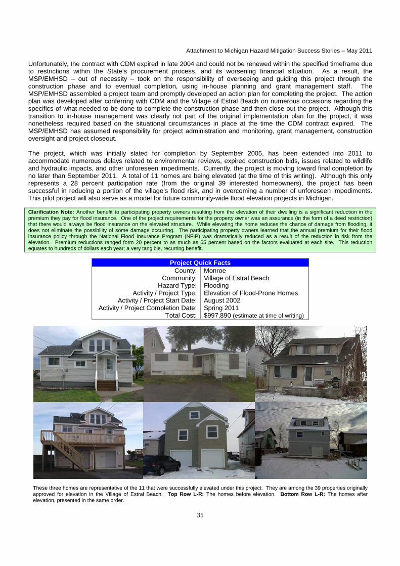
Attachment to Michigan Hazard Mitigation Success Stories – May 2011
35
Unfortunately, the contract with CDM expired in late 2004 and could not be renewed within the specified timeframe due to restrictions within the State’s procurement process, and its worsening financial situation. As a result, the MSP/EMHSD – out of necessity – took on the responsibility of overseeing and guiding this project through the construction phase and to eventual completion, using in-house planning and grant management staff. The MSP/EMHSD assembled a project team and promptly developed an action plan for completing the project. The action plan was developed after conferring with CDM and the Village of Estral Beach on numerous occasions regarding the specifics of what needed to be done to complete the construction phase and then close out the project. Although this transition to in-house management was clearly not part of the original implementation plan for the project, it was nonetheless required based on the situational circumstances in place at the time the CDM contract expired. The MSP/EMHSD has assumed responsibility for project administration and monitoring, grant management, construction oversight and project closeout. The project, which was initially slated for completion by September 2005, has been extended into 2011 to accommodate numerous delays related to environmental reviews, expired construction bids, issues related to wildlife and hydraulic impacts, and other unforeseen impediments. Currently, the project is moving toward final completion by no later than September 2011. A total of 11 homes are being elevated (at the time of this writing). Although this only represents a 28 percent participation rate (from the original 39 interested homeowners), the project has been successful in reducing a portion of the village’s flood risk, and in overcoming a number of unforeseen impediments. This pilot project will also serve as a model for future community-wide flood elevation projects in Michigan. Clarification Note: Another benefit to participating property owners resulting from the elevation of their dwelling is a significant reduction in the premium they pay for flood insurance. One of the project requirements for the property owner was an assurance (in the form of a deed restriction) that there would always be flood insurance on the elevated structure. While elevating the home reduces the chance of damage from flooding, it does not eliminate the possibility of some damage occurring. The participating property owners learned that the annual premium for their flood insurance policy through the National Flood Insurance Program (NFIP) was dramatically reduced as a result of the reduction in risk from the elevation. Premium reductions ranged form 20 percent to as much as 65 percent based on the factors evaluated at each site. This reduction equates to hundreds of dollars each year; a very tangible, recurring benefit.
Project Quick Facts County:
Community: Hazard Type:
Activity / Project Type: Activity / Project Start Date:
Activity / Project Completion Date: Total Cost:
Monroe Village of Estral Beach Flooding Elevation of Flood-Prone Homes August 2002 Spring 2011 $997,890 (estimate at time of writing)
These three homes are representative of the 11 that were successfully elevated under this project. They are among the 39 properties originally approved for elevation in the Village of Estral Beach. Top Row L-R: The homes before elevation. Bottom Row L-R: The homes after elevation, presented in the same order.

Attachment to Michigan Hazard Mitigation Success Stories – May 2011
36
Gratiot County Culvert Replacement
A hazard mitigation success story from Federal Disaster 1346-DR-MI involved a culvert replacement project undertaken by the Gratiot County Road Commission. Just prior to the application and project selection period for the HMGP under Federal Disaster 1346-DR-MI, the Road Commission discovered a threatening situation with potential catastrophic impacts. One of two culverts in a twin culvert system on Otter Creek had buckled and the undersized system was doomed to imminent failure. Failure of the system would result in the washing of 3,800 cubic feet of road fill into Rainbow Lake and the collapse of two sewer mains (serving 420 hookups, including residential structures, schools and an adult foster care facility) that would dump raw sewage into the creek and Rainbow Lake. The Gratiot County Road Commission applied for a project to replace the twin culvert system with a single span concrete box culvert. The MHMCC selected the Gratiot County project and asked FEMA to make it a priority project in the approval process. The MSP/EMHSD worked with FEMA and Congressman Dave Camp’s office to keep the project moving forward in a timely manner. FEMA gave final approval for the grant in March 2002 and the project was completed in October 2002.
Project Quick Facts County:
Community: Hazard Type:
Activity / Project Type: Activity / Project Start Date:
Activity / Project Completion Date: Total Cost:
Gratiot Fulton Township Severe Storms; Flooding Drainage Improvements April 2002 October 2002 $384,012
Photos L-R show the new box culvert, stream bank stabilization measures, and roadway enhancements which are designed to improve drainage and better protect the roadway infrastructure.
Marquette County Hazardous Dam Removal
A successful hazardous dam removal project in Marquette County was completed in September 2005 using HMGP funding under Federal Disaster 1346-DR-MI. The project involved the removal of the Collinsville Dam on the Dead River – a 200-foot long dam that was about 120 years old and held back approximately five acres of water. This project is a definite hazard mitigation success story because the aging dam posed a significant threat to life, property and the environment. Removal of the dam eliminated flood risk to four downstream homes and a downstream electrical substation (and imminent power failure for the 1,850 residences and 150 businesses served by it), threat of loss of life to downstream fishermen and people participating in recreation activities in a city park, and damaging siltation of the downstream fishery and a public beach. The removal of the dam was a complex, multi-phase engineering and construction effort that involved: 1) construction of a coffer dam (a temporary structure that allows water to be pumped out to create a dry work environment); 2) installation of 250 feet of temporary diversion pipe (to handle stream flow); 3) construction of a downstream silt trap; 4) demolition of the dam and removal of debris; 5) removal of 1,500 cubic yards of non-contaminated silt; 6) installation of 600 cubic yards of fabric and rip-rap to stabilize the bank; and 7) mulching and re-vegetation of four acres of reclaimed land with native plant and tree species.

Attachment to Michigan Hazard Mitigation Success Stories – May 2011
37
Project Quick Facts
County: Community:
Hazard Type: Activity / Project Type:
Activity / Project Start Date: Activity / Project Completion Date:
Total Cost:
Marquette Marquette Township Infrastructure Failure; Flooding Removal of Hazardous Dam October 2003 September 2005 $126,628
Top Row: Aerial photo depicts the old impoundment and new river channel. Bottom Row L-R: Collinsville Dam before removal; excavators removing the dam; re-vegetation and rip-rap along the river after dam removal.

Attachment to Michigan Hazard Mitigation Success Stories – May 2011
38
Innovative Stormwater Floodplain Simulation Model*
Thanks to the determination of a National Weather Service hydrologist and a Michigan high school science teacher, earth science students around the country have access to a simple, portable and educational floodplain model. WARD'S Stormwater Floodplain Simulation System, which is based on a NOAA prototype, became available for purchase in the fall of 2009. A floodplain is a strip of relatively flat and normally dry land alongside a stream, river or lake that is covered by water during a flood. The model was created to help explain river hydrology and how changes in a watershed — the drainage basin that empties into a river or other body of water — can impact flood risk. In 2006, science teacher Dave Chapman of Okemos High School in Okemos, Michigan approached hydrologist Mark Walton of NOAA’s Grand Rapids, Michigan weather forecast office about developing a more interactive approach to teaching students about flood risk and hydrology — the study of water movement, distribution and quality throughout the Earth. Over the next six months, they worked together to develop a proposal that included a flood management curriculum and specifications for a hands-on stormwater-floodplain model. With proposal in hand, the pair approached various water management agencies looking for help to make their plans a reality. Officials from the Michigan Stormwater-Floodplain Association were interested in the project. The association provided funds to build two prototypes. “It took some persistence to convince someone to fund the first two prototypes,” Walton said. “Part of that was simply finding the right group. It had to be people who understood the many, complex variables that impact flooding and how changing conditions in a watershed, such as urbanization, impact flood risk.” Walton and Chapman used the models whenever and wherever they found the opportunity: science shows, conferences, career days, water festivals and water management meetings. The model was demonstrated any place people gathered to discuss flooding and water management. Students, teachers, flood experts and water managers were all impressed. During a demonstration at a May 2009 earth science teachers’ conference in Grand Rapids, another exhibitor, WARD’s Natural Science of Rochester, New York, took notice. WARD’s product development managers approached Chapman and Walton about partnering to mass produce the floodplain models. They reached an agreement quickly, and WARD’s is now producing the models under the name “WARD'S Stormwater Floodplain Simulation System.” The product hit the market in the fall of 2009. “The simulation model and curriculum guide provide teachers with defined activities and procedures that help students visualize the hazards of flooding,” Walton said. As an added bonus, 10 percent of the proceeds from each model sold go to the Michigan Stormwater-Floodplain Association Scholarship Fund. “The National Weather Service [also] gets the satisfaction of knowing we helped provide a hydrologic education tool that will give thousands of students a better understanding of the causes of and the hazards associated with flooding,” Walton said. But, he added, the benefits don’t end there. “We’ve found this model is an effective teaching tool for more than students,” said Walton. “It’s a great tool for giving basic hydrology instruction to people in the water control and water management fields and for the general public.”
(*From August 19, 2009 NOAA / NWS web article originally written by Patrick Slattery, NOAA Communications and External Affairs; reprinted with permission but edited for formatting and clarity purposes.)
Project Quick Facts
County: Community:
Hazard Type: Activity / Project Type:
Activity / Project Start Date: Activity / Project Completion Date:
Total Cost:
Statewide Statewide Severe storms; Flooding Educational Demonstration Model 2006 2009 $N/A

Attachment to Michigan Hazard Mitigation Success Stories – May 2011
39
Innovative Stormwater Floodplain Simulation Model (cont.)
A Model for Flood Safety
The stormwater-floodplain model is easy to use, portable and inexpensive, and comes with a teaching curriculum and experiments. The curriculum examines such topics as: 1) the fate of rain; 2) why rivers flood; 3) the importance and role of floodplains; 4) the National Weather Service’s “Turn Around, Don’t Drown” public awareness campaign; 5) methods of protecting life and property from floods; and 6) an exercise on how to create a flood-safe community. The model allows students to experiment with three different scenarios for water runoff: a wetland, a parking lot and a stormwater retention pond. River levels are measured with an integrated water level gauge, and the floodplain can be modified by the addition of a levy or fill. The slope of the land and modeled rainfall intensity can be modified to show differing impacts. Educational experiments require students to measure the quantity of rainfall and runoff, as well as the timing and crest of the river with various slopes, rainfall rates, headwaters and floodplain configurations. Students can use data from the experiments to develop charts that display the change of a hydrologic variable over time and to illustrate how changes in the watershed impact flood characteristics. A video demonstration and more information about how to purchase WARD'S Stormwater Floodplain Simulation System can be found at: http://wardsci.com/article.asp?ai=1338&cm_mmc=WA-_-LP-_-Product-_-Stormwater&sid=floodplain&eid=&bhcd2=1256231402; or, go to the web site (http://wardsci.com) and type in the title of the product in the search box.
Photo credit: With permission from WARD’s Natural Science and NOAA / NWS.

Attachment to Michigan Hazard Mitigation Success Stories – May 2011
40
Lake / Mason / Osceola County NOAA Weather Early Warning Enhancement
In August 2005, the counties of Lake, Mason and Osceola completed a joint project to install a NOAA weather transmitter with funding from the HMGP under Federal Disaster 1346-DR-MI. This project represents a mitigation success story in that it will help minimize the impacts of severe weather by providing advance warning to residents. In the three counties, like in many other rural areas of Michigan, providing early warning of approaching severe weather can be challenging. Warning sirens are not always effective because the population is often disbursed over a larger geographic area than the audible signal can reach. This NOAA transmitter, installed in Lake County near the Osceola County line, has a signal that reaches approximately 60,000 residents and can even be picked up at Lake Michigan. Because a NOAA alert radio is required to hear the warning signal, a project such as this requires an extensive public education campaign for the project to be optimally successful. Once residences, businesses, schools, institutions and other public facilities are equipped with NOAA alert radios, residents will know to take cover when severe weather is approaching. In support of this early warning enhancement project, the three counties are working to purchase and distribute NOAA alert radios for residents that cannot afford one.
Project Quick Facts County:
Community: Hazard Type:
Activity / Project Type: Activity / Project Start Date:
Activity / Project Completion Date: Total Cost:
Lake / Mason / Osceola All Local Communities Severe Weather / Storms Early Warning Enhancement December 2001 August 2005 $83,821
Photos L-R: Transmitter equipment building with back-up generator; transmission equipment inside transmitter equipment building.
Oakland County / Waterford Township Cross-Connection Elimination Program
In October 2003, an innovative public education project was completed in Waterford Township, Oakland County, using HMGP funds from Federal Disaster 1346-DR-MI. The project involved the development and dissemination of educational materials to homeowners in an effort to mitigate the back-up of sewage into homes. The brochure pictured on the following page was developed to explain to residents why it is important to disconnect their home’s stormwater collection systems from the sanitary sewer. The project’s goal is to minimize unnecessary contributions to the sanitary sewer system so that sewage will not back-up into homes and cause property damage and health problems. Because of the positive reception the program has received from Waterford Township residents and its success thus far, the initial distribution of 1,000 brochures has since been expanded to cover a wider audience.

Attachment to Michigan Hazard Mitigation Success Stories – May 2011
41
Project Quick Facts
County: Community:
Hazard Type: Activity / Project Type:
Activity / Project Start Date: Activity / Project Completion Date:
Total Cost:
Oakland County Waterford Township Infrastructure Failure; Flooding Public Education February 2002 October 2003 $7,582
Top Photo: Front and back of the brochure before being folded. Bottom Photo: Inside of the brochure before being folded.

Attachment to Michigan Hazard Mitigation Success Stories – May 2011
42
Leelanau County Mass Gathering Ordinance
Clarification Note: The following project identified by the Leelanau County Office of Emergency Management does not necessarily fall neatly under the realm of “hazard mitigation,” per se (it may be thought of more as a preparedness activity). However, the idea to enact the ordinance emanated from the hazard mitigation planning process and its intent is to require proper event planning to reduce the potential for harm to persons attending mass gathering events such as festivals, fairs, parades and sporting events. In addition, the fact that such plans are required by ordinance is unique and certainly qualifies it as a success story in terms of a population protection measure.
In 2006, Leelanau County undertook an initiative to develop its natural hazards mitigation plan, working in conjunction with the Northwest Michigan Council of Governments. Once the document was approved at the county level in the fall of 2007, an offer was made to the townships and villages to adopt the plan for inclusion into their Master Plan or General Plan (different names, same process) as one of their required sections. In early 2009, the county Emergency Manager started attending township and village meetings to provide them an opportunity to discuss the plan and address comments and concerns relative to the plan. This was also the time when many of the townships and villages were gearing up to work on their Master Plans or General Plans. During these discussions, township and village officials expressed considerable interest in the hazard mitigation plan and found it to be an excellent document. Several of the township boards asked what they could do at their level to assist in mitigation efforts in their respective jurisdictions. As they studied the plan, several focused on an area they felt they could embrace and easily accomplish by means of an ordinance or by law; namely, a requirement that mass gathering events have an evacuation plan. Several passed a “Mass Gathering Ordinance” that was incorporated into the hazard mitigation section of their Master Plan or General Plan as a vital mitigation strategy to protect public safety at festivals, fairs and other mass gathering events. This is now mandated for events expected to have large crowds (over 500 people) in a relatively confined area (e.g., a township park). The townships and villages that have passed the ordinance require the event organizer to meet with the county Emergency Manager, Fire Chief, Sheriff and EMS Director to develop a pre-event response plan. This plan is then written by the Emergency Manager and issued to the Sheriff, Fire Chief, Event Coordinator and 911 Dispatch Center. The plan identifies specific duties and responsibilities, traffic flows, emergency contact numbers, names, radio channel assignments, chain of command, etc., and uses standard Incident Command System (ICS) forms. The plans are scalable to event size and complexity, and as they grow so too does the number and type of planners and stakeholder groups involved in the development of the plan. Because of the success of this initiative, emergency services providers are now requesting plans for more than just the mass gatherings defined in the ordinance, including smaller and/or less geographically confined events such as fireworks shows, parades and events that take place at multiple locations in the community. The Leelanau County Mass Gathering Ordinance can serve as a model for other communities to emulate in their pre-incident planning to protect the health and safety of attendees at community events.
Project Quick Facts County:
Community: Hazard Type:
Activity / Project Type: Activity / Project Start Date:
Activity / Project Completion Date: Total Cost:
Leelanau Countywide All Hazards Mass Gathering Ordinance 2006-07 2009 $N/A

Attachment to Michigan Hazard Mitigation Success Stories – May 2011
43
Michigan’s “Project Impact” Communities
In 1997, FEMA launched the “Project Impact” initiative with seven pilot communities across the country. Project Impact was established to create public-private partnerships to make local communities more disaster resistant. Project Impact expanded considerably during the period from 1998-2001, when each state was allowed to designate one local community per year to become a Project Impact Community. Each designated Project Impact Community received a three-year grant from FEMA to use as seed money for identifying risks to the community, establishing public-private partnerships to reduce risk and vulnerability, and undertaking measures to make the community more disaster resistant. In Michigan, two counties (Ottawa and Ingham) and two cities (Midland and Dearborn) were selected as Project Impact Communities. Although Project Impact was replaced within FEMA by other initiatives and eventually closed out in 2004, it left a lasting legacy in Michigan and across the country. Project Impact has made communities more disaster resistant, helped save lives and protect property, and built solid public-private partnerships that will continue to provide benefits for years to come.
1998 Project Impact Community – City of Midland The City of Midland’s Project Impact initiatives included: 1) inspecting and cleaning drains in the Snake Creek Basin to reduce flooding; 2) providing community outreach regarding the city’s hazards and risks; 3) installing additional emergency warning sirens; 4) providing a telephone information line for individuals during large disasters; 5) conducting public information campaigns to minimize the effects of hazardous events; and 6) providing ongoing planning to refine and improve response to natural and technological hazards. The city closed out its Project Impact grant in the summer of 2001.
1999 Project Impact Community – Ottawa County Ottawa County’s Project Impact initiatives included: 1) developing a countywide hazard analysis and hazard mitigation plan (which was instrumental in the rapid development of the Robinson Township hazard mitigation plan discussed on page 14); 2) partnering with WOOD TV 8 for public service announcements on various weather related topics; 3) developing a two-page information sheet on Project Impact and emergency preparedness that was published in the 2001 Ameritech telephone book for Ottawa County; and 4) installing “dry” fire hydrants in needed locations across the county. (Dry fire hydrants consist of an L-shaped PVC line that taps a pond or stream at one end and holds a connection for pumping water into a tanker truck at the above-ground end. They are inexpensive, easily constructed, and a highly effective means to tap into remote water supplies for firefighting.) The county closed out its Project Impact grant in the spring of 2002.
2000 Project Impact Community – City of Dearborn The City of Dearborn’s Project Impact initiatives included: 1) designing and building a “safety town” model cityscape where children could be informed about traffic safety and adults could learn about ways to “disaster-proof” their homes and businesses; 2) developing a citizen handbook on the principal hazards and threats facing Dearborn; 3) developing a detailed community hazard analysis; and 4) creating two web pages focusing on disaster public education. (The two web pages, titled “Preparing Your Home / Business for a Disaster” and “Preparing for a Disaster”, were posted on the city’s web site.) The city closed out its Project Impact grant in early 2003.
2001 Project Impact Community – Ingham County
Ingham County, Michigan’s fourth and final Project Impact Community, implemented the following Project Impact initiatives: 1) developing a hazard analysis, risk assessment and hazard mitigation plan; 2) purchasing pumps to alleviate flooding in a residential area; 3) distributing “Masters of Disaster” curriculum kits in area elementary schools; 4) running disaster related public service announcements with FOX 47 television; 5) conducting “Skywarn” training for weather spotters; 6) providing emergency kits in all new Habitat for Humanity homes; 7) providing weather alert radios for county schools; and 8) developing a “FIREWISE” model community project. Ingham County closed out its Project Impact grant in December 2004. Note: Refer to the separate “Wildfire Prevention in Southern Michigan” mitigation success story on page 49 for additional information on the Ingham County FIREWISE model community project. Since the completion of the Project Impact initiative, a lasting partnership has occurred between Michigan State University Extension and FOX 47 television. FOX 47 is still airing the public service announcements about wildland fires that were created with Project Impact funding.

Attachment to Michigan Hazard Mitigation Success Stories – May 2011
44
Project Quick Facts
County: Community:
Hazard Type: Activity / Project Type:
Activity / Project Start Date: Activity / Project Completion Date:
Total Cost:
Counties of Ingham and Ottawa Cities of Dearborn and Midland All Hazards Public-Private Partnership 1998 2004 $2,000,000 ($500,000 per jurisdiction)
Top Row L-R: Project Impact helped bring community leaders together to build public-private partnerships to make communities more disaster resistant. Middle and Bottom Rows L-R: Project Impact funds were used for such activities as installation of dry fire hydrants, purchase of weather radios and home emergency kits, creation of wildfire prevention public service announcements, and clearing of drains to prevent flooding.
Michigan Hazard Mitigation Plan Certified Under Federal Disaster Mitigation Act of 2000
The federal Disaster Mitigation Act (DMA) of 2000 requires states to develop and maintain a FEMA-approved, comprehensive state hazard mitigation plan as a condition of being eligible to receive federal Hazard Mitigation Assistance (HMA) funding, federal Public Assistance (PA) funding for permanent disaster relief work (Categories C-G), and federal Fire Management Assistance (FMA) funding to fight large-scale, escalating wildland fires. Both individually and collectively, these three funding streams can result in millions of dollars in federal assistance for the State of Michigan and its local jurisdictions. This made the successful and timely completion of a state hazard mitigation plan a critically important undertaking.
Initial Edition The State’s initial edition of the Michigan Hazard Mitigation Plan (MHMP) was completed in 2004 by a dedicated planning team which consisted of several members of the MSP/EMHSD Planning Section, the MHMCC, 14 state departments (and numerous sub-units within), and over 20 nongovernmental organizations. This initial planning effort focused on mitigation of the 12 natural hazards specified in federal guidelines.

Attachment to Michigan Hazard Mitigation Success Stories – May 2011
45
The DMA 2000 requires that a rigorous risk assessment process be carried out as a foundation for the mitigation planning effort. Part of that risk assessment process involves the examination of hazard losses for “state owned / operated critical facilities.” The planning team identified 503 state facilities that met that definition. Loss estimations for the natural hazards were calculated for all 503 facilities, as well as the 4.2+ million residential structures in Michigan’s 83 counties. The plan also featured a comprehensive capability assessment section that addressed both natural and technological hazards. (Technological hazards were included in the capability assessment to lay the groundwork for a future plan expansion that would include technological as well as human-related hazards, in addition to the natural hazards required by federal guidelines. The expansion occurred in the 2011 plan edition; see details below.) Most importantly, the plan proposed a total of 185 specific mitigation actions designed to address the vulnerabilities identified in the risk assessment and capability assessment sections. These actions were prioritized by the MHMCC and MSP/EMHSD for implementation under the plan’s four major goals and 68 strategic objectives. The initial MHMP was developed using the “best available data” at the time. The primary sources for the natural hazard damage data included the National Weather Service, the National Climatic Data Center, the U.S. Geological Survey, and the National Flood Insurance Program. Several state departments provided geo-spatial data (from which location-specific hazard areas were determined) and/or critical facility data (from which loss estimations were made). The MHMCC formally adopted the initial MHMP on October 19, 2004, and the State of Michigan adopted it on December 15, 2004. The 1,357-page plan was submitted to FEMA for federal certification under the DMA 2000. FEMA approved the plan on March 27, 2005, as a “Standard State Mitigation Plan” under the federal DMA 2000, thereby ensuring that the State and its local jurisdictions remained eligible for federal HMA, PA and FMA funding for the next three years. More importantly, the federally-approved plan provided an excellent roadmap for the development and implementation of needed hazard mitigation measures within the State of Michigan that have regional and/or statewide applicability or impact.
Federally-Required Plan Updates (2008 and 2011) The DMA 2000 mandates that state hazard mitigation plans be updated every three years as a requirement for continued federal hazard mitigation and disaster relief assistance, so the State was required to complete comprehensive plan updates in 2008 and 2011. Virtually every page of the plan had to be updated – a process that took months to complete due to the complexity and sheer volume of work as well as the small number of state planning staff that were available to assist in the process. Despite these impediments, the MSP/EMHSD successfully completed its first comprehensive plan update in early 2008, and that edition of the MHMP was certified by FEMA as being DMA 2000 compliant on March 27, 2008. The 2008 planning effort included not only an update and revision of the 2005 edition of the MHMP but also an update of several important companion documents including the “Michigan Hazard Analysis” (MSP/EMHSD Publication 103) and the “Funding Sources for Hazard Mitigation” guidebook (MSP/EMHSD Publication 207a). In addition, new sections were added to the MHMP to: 1) connect state and local planning activities; 2) incorporate new hazard history information; 3) analyze local and regional development pressures; 4) summarize hazard risks described in local hazard mitigation plans; and 5) assess local program capabilities for mitigating hazards. At 609 pages, the 2008 update was less than half the size of the initial 2005 edition (1,357 pages), but that was due primarily to an MSP/EMHSD-initiated reduction in certain plan sections coupled with changes by FEMA in plan standard interpretation. On March 25, 2011, after months of planning work by MSP/EMHSD staff, the MCCERCC and a wide array of stakeholders, the MSP/EMHSD received official notice that the 2011 edition of the MHMP had been approved by FEMA under the federal DMA 2000. (Three days earlier, on March 22, 2011, Governor Rick Snyder had signed and formally adopted the plan for the State of Michigan, the final step before federal approval. The federal approval is good for a three-year period, expiring on March 25, 2014.) The 928-page, 2011 update includes a significant expansion in plan scope to include technological and human-related hazards – a move required by the State’s efforts to seek accreditation of its emergency management and homeland security program under the National Emergency Management Association’s “Emergency Management Accreditation Program” (EMAP). The EMAP standards for state hazard mitigation plans are more comprehensive in nature than the federal DMA 2000 planning standards. The EMAP standards require states to address the full range of hazards in their hazard mitigation plans, to include natural, technological and human-related hazards. This additional requirement resulted in a significantly expanded MHMP, as well as significant additions to the companion Michigan Hazard Analysis (MHA) document. (In December 2010, the State was notified that its technological and human-related hazard additions to the MHMP and MHA had been approved under the EMAP accreditation process.)

Attachment to Michigan Hazard Mitigation Success Stories – May 2011
46
Project Quick Facts
County: Community:
Hazard Type: Activity / Project Type:
Activity / Project Start Date: Activity / Project Completion Date:
Total Cost:
State of Michigan Statewide All Hazards Planning 2003 for initial version of plan Ongoing; revised every three years $N/A – staff time only
Michigan Emergency Alert System Enhancements*
In September 2004, the Michigan Association of Broadcasters (MAB) partnered with the MSP/EMHSD to complete a Michigan Emergency Alert System (EAS) enhancements project using HMGP funds under Federal Disaster 1346-DR-MI. The project was developed to correct several deficiencies in the ability of the Michigan EAS to deliver emergency information to virtually all of the Upper Peninsula and to improve the reliability of coverage over approximately the upper one-third of the Lower Peninsula. The project provided two paths for the emergency information to take: 1) via the Internet, to two locations where high speed Internet is available at the primary station; and 2) via a privately owned satellite-based radio network, which provides access to their network for emergency use only, as a public service. (The uplink of this firm is in Lansing, and it is fed from the State Primary EAS station via an off-air pickup.) The project had multiple components: • Provide an Internet-based audio delivery of emergency messages from either the State Emergency Operations
Center (SEOC) in Lansing or the federal government, to each of the large and underserved geographic areas noted above utilizing the high power FM stations (and associated repeater stations) of Northern Michigan University (Marquette) and Central Michigan University (Mt. Pleasant).
• Install satellite-based reception equipment at Northern Michigan University and Central Michigan University, to
provide a necessary back-up to the Internet-based system. • Install satellite reception equipment at the LP-1 station in Ironwood to serve Michigan’s most western counties
(Gogebic and Ontonagon), thus providing a path for emergency information that cannot be received from neighboring EAS radio stations in Michigan due to the extreme distance and mountainous terrain.
• Install satellite reception equipment at the LP-1 station in Detroit to back-up the present single off-air reception path
from the State Primary EAS Station in East Lansing. • Supply additional EAS encoder / decoders in Detroit at the LP-1 and LP-2 stations, to accommodate the additional
signals from the added satellite receiver and five local county EOCs which have EAS encoders. (This helps to speed up emergency messaging from these counties into the station’s EAS response system.)
• Supply the needed microphones, audio processing and editing software to allow both pre-recorded and live
messages to be composed and transmitted from the SEOC in Lansing, via the existing EAS equipment installed there, to the State Primary EAS Station, and then through the relay system to the state at large.
Internet Audio Delivery System. A dedicated Internet audio delivery system was purchased. The “Tele-Link” input terminal is located at WKAR-FM, East Lansing, which is the State Primary EAS station. The continuous audio output of this station is streamed on the Internet to receiver units located at WCMU-FM, Mt. Pleasant and at WNMU-FM, Marquette.
THE REMAINDER OF THIS PAGE INTENTIONALLY LEFT BLANK.

Attachment to Michigan Hazard Mitigation Success Stories – May 2011
47
Michigan Emergency Alert System Enhancements (cont.)
Photos (Left): “Telelink” audio streaming equipment installed in an audio terminal room at WKAR-FM, East Lansing. The processor unit is the black unit near the bottom of left rack. (Middle): WKAR-FM audio levels being transmitted on the “Tele-Link” Internet streaming equipment are continuously displayed. The system is bi-directional, so audio from the two distant sites can be verified for proper operation. The audio quality is excellent. This path could be utilized for other long form emergency information programming, originating from the SEOC, from the station’s own studios, or both. (Right): “Tele-Link” equipment shown in operation at WNMU-FM, Northern Michigan University, Marquette.
Photos (Left): A dedicated satellite receiver installed at WNMU-FM, Northern Michigan University, Marquette, which is tuned to the Michigan Radio Network, providing a second, back-up path. (Middle): “Tele-Link” unit in operation at WCMU-FM, Central Michigan University, Mt. Pleasant. (Right): A dedicated satellite receiver installed at WCMU-FM, Central Michigan University, Mt. Pleasant, tuned to Michigan Radio Network, which becomes the second path in the event of a failure.
Satellite Delivery. A 4.6 meter receive-only satellite antenna, aimed at Galaxy 4R, is now located at WUPM-FM, Ironwood. The station serves as the EAS Local Primary 2 station for the Western Upper Peninsula. The antenna continuously receives Michigan Radio Network, which is up-linked in Lansing and monitors the State Primary Station with its EAS equipment. At WUPM-FM, the audio from Michigan Radio Network is continuously fed into the station’s EAS equipment. This link would be used in a National or State Emergency. A satellite receiver was also provided to WJR, Detroit. It is installed at the station’s transmitter site where the station has a complete emergency broadcast studio as well as back-up transmitters, a transmitting antenna, dual power feeds and a back-up generator. The receiver’s signal is split off from an existing satellite receiving antenna. In a National or State Emergency, this path backs up the off-air reception of WKAR-FM at the WJR studio. Due to the large number of possible emergency sources (State of Michigan, five county EOCs, National Weather Service, Michigan Radio Network satellite, and the other Local Primary Station), a second, more capable EAS encoder / decoder was supplied and EAS encoder / decoders are now operational at WJR and WWJ, the two Local Primary Stations serving the five counties of the Southeastern Michigan area. State EAS Entry Point. The Michigan EAS entry point is located at the SEOC in Lansing. From this location, an EAS message can be created and then sent to the State Primary Station for distribution any time, day or night. The equipment is interconnected in a very flexible manner that allows the emergency message to be recorded by the Governor or other official using a microphone / headset (see photo on following page). The audio may be delivered “live,” or preferably, first recorded using computer audio software and then electronically edited and transmitted. Audio levels are pre-processed for maximum clarity through the transmission process. Although EAS messages must be less than two minutes in length, this equipment is also wired to provide the ability for longer audio messages, emergency statements, press conferences, etc. to be sent live to the State Primary Station for a special broadcast or updates. The primary transmission path is a dedicated, hard-wired equalized audio program loop with a two-way radio and standard dial-up phone line as back-ups.

Attachment to Michigan Hazard Mitigation Success Stories – May 2011
48
Should the Governor or other key officials not be present at the SEOC, the equipment also allows audio files to be e-mailed to the computer, opened and edited. Also, a portable audio recorder and microphone (see photo below) using Compact Flash (CF) memory card as the storage medium can be carried directly to where the Governor or other official is located. The data is then played off the card by a simple CF reader directly into the computer, edited and transmitted. EAS / Weather Relay System in the Upper Peninsula. Since 95 percent of the uses of the EAS are for weather related emergencies, coupled with the extensive coastal waters of the Great Lakes, delivering important weather information is critical to residents of the Upper Peninsula. Because many areas are not presently served by National Weather Service radio stations and there are no funds to build such stations in the foreseeable future, a different means of getting this weather information to the broadcast stations was needed. With the cooperation of Northern Michigan University’s Public Broadcasting TV station (WNMU-TV), Charter Cable, the National Weather Service is preparing to provide a continuous audio feed of this information. A television Separate Audio Program (SAP) generator was also purchased as part of this grant and is placed at the WNMU-TV transmitter site. The special audio feed is therefore added and transmitted on the signal of WNMU-TV as a separate audio sub-carrier. This station is distributed by Charter Cable throughout the central, southern and eastern portions of the Upper Peninsula. Broadcast stations and the general public will be able to utilize this important weather information directly by tuning in the SAP channel, or connecting it to their existing EAS equipment. As NOAA moves Weather Radio to an all-hazards warning service, this unique distribution method will become even more valuable in the Upper Peninsula.
Photos L-R: Satellite antenna located at WUPM-FM, Ironwood. Michigan EAS entry point located at the SEOC in Lansing. A portable audio recorder and microphone, using Compact Flash memory card as the storage medium, can be used by the Governor or other authorized official to record messages when not in the SEOC. Adobe Audition audio software is loaded on the SEOC EAS computer and used for the recording, editing and management of pre-recorded and new audio messages.
System Testing. Two complete tests of the Michigan EAS occur per year. Both originate at the SEOC, are then broadcast by the State Primary EAS station, and then received via direct off-air pickup of that signal in four regions, through a State Relay Station to two other areas, via Internet streaming path to three areas, and via satellite to the western Upper Peninsula. These tests are encoded as Required Monthly Tests, with re-broadcast required of all stations and cable systems within one hour of receipt. Routine weekly tests are transmitted by the State Primary EAS Station but are not required to be relayed or re-broadcast, just logged at the receiving stations. (*Edited / reformatted version of original project completion report for HMGP grant # A1346.541, submitted by Larry Estlack, Director of Technology, Michigan Association of Broadcasters Foundation, September 17, 2004.)
Project Quick Facts
County / Community:
Hazard Type: Activity / Project Type:
Activity / Project Start Date: Activity / Project Completion Date:
Total Cost:
Upper Peninsula; Northern Lower Peninsula All Hazards Early Warning Enhancements June 2002 September 2004 $73,013

Attachment to Michigan Hazard Mitigation Success Stories – May 2011
49
Wildfire Prevention in Southern Michigan*
The “Wildfire Prevention in Southern Michigan” project, also referred to as the “Michigan FIREWISE** Communities” project, was a two-year educational effort undertaken by the Michigan Department of Natural Resources (MDNR) and Michigan State University Extension (MSUE) to: 1) enhance public knowledge of wildfire threats in southern Lower Michigan and to share relevant findings and information with other parts of the state; 2) assess the effectiveness of the FIREWISE Communities Program in Michigan, beginning with the southern Lower Michigan region; 3) explore the effectiveness of MSUE in enhancing the wildfire educational efforts of MDNR staff; 4) examine and test various wildfire instructional and mitigation methods; and 5) identify and develop partnerships to increase citizen, public official and private sector awareness of wildfire threats and prevention. A total of 30 Southern Michigan counties participated in this MDNR-initiated pilot project. The two-year educational effort was successful in: 1) directly educating 2,228 residents about wildfire prevention and responding to over 6,500 other contacts for information and/or orientation purposes; 2) reaching at least 48,550 other residents through extended education or mass media activities; 3) providing training and wildfire prevention information to 910 community leaders and local officials; 4) establishing two FIREWISE Model Communities; 5) 27 of the 30 counties receiving orientation and/or community FIREWISE assessments; and 6) developing two new MSUE bulletins on wildfire mitigation and prevention, written in both English and Spanish. The project was successful in enhancing MDNR wildfire educational efforts while at the same time solidly vesting MSUE in wildfire education and mitigation activities. Combining the MDNR technical expertise in wildfire mitigation and suppression with the instructional expertise and information distribution networks of MSUE provided an excellent mix for wildfire education and mitigation outreach. MSUE, with its extensive networks in local communities, has been able to open doors to new groups and opportunities for wildfire education, including not only external organizations but also MSUE workshops and programs. The MDNR fire management staff has a wealth of information about wildfire behavior and mitigation, knowledge of FIREWISE concepts, and basic experience in observing, suppressing and understanding wildfires. As a result of this project, alliances and/or joint programming efforts have been developed with local government agencies as well as with nongovernmental organization partners such as FOX 47 Television, the Greater Lansing and Greater Grand Rapids Homebuilders Associations, Kalamazoo County Master Gardeners, Lowe’s Home Improvement Warehouse, and the Michigan Christmas Tree Association. (*Condensed / reformatted version of original 2004 project report submitted by Donald Johnson, Michigan Department of Natural Resources [MDNR], on behalf of the MDNR and Michigan State University Extension.) (**FIREWISE is a voluntary, community-wide wildfire prevention and mitigation program administered by the National Fire Protection Association and co-sponsored by the U.S. Department of Agriculture / Forest Service, U.S. Department of the Interior, and the National Association of State Foresters.)
Project Quick Facts
County: Community:
Hazard Type:
Activity / Project Type: Activity / Project Start Date:
Activity / Project Completion Date: Total Cost:
30 Southern Michigan Counties Two Model Communities in Ingham County and Ottawa County Wildfire Public Education October 2001 June 2004 $304,952
Photos: The Wildfire Prevention in Southern Michigan project will help make scenes such as these less common in Michigan.

Attachment to Michigan Hazard Mitigation Success Stories – May 2011
50
St. Clair County / City of Port Huron Standby Power Source for Water Treatment Plant
In 2002-03, the City of Port Huron purchased and installed a standby generator for its water treatment plant using HMGP funding under Federal Disaster 1346-DR-MI. The city undertook this critical infrastructure failure mitigation project to ensure the continued operation of the water treatment plant for an extended time period during an electric power failure. As luck might have it, the new generator was put to the test shortly after it was installed. On August 14, 2003, much of the northeast United States and Ontario was hit by the largest electrical blackout in North America’s history. Electricity was cut to 50 million people, bringing darkness to customers from New York to Michigan. When the Port Huron water treatment plant lost primary power on August 14, the new generator was activated and provided reliable power to allow the plant to continue operating. The success of this mitigation measure was perhaps best summed up by the plant’s superintendent, Thomas C. Deaner, in his September 22, 2003 letter to the MSP/EMHSD. In that letter, Mr. Deaner said, “The timing for completion (of the project) couldn’t have been better. When the Blackout of 2003 hit on August 14th this was the exact scenario we contemplated to warrant back-up power. Our new generator operated flawlessly for the next 39 hours, enabling us to provide potable water to the citizens of Port Huron and the townships of Port Huron, Fort Gratiot, Clyde and Kimball until power was restored and we transferred back to our Edison feed.” This mitigation project will help protect the health of the citizens of Port Huron and surrounding communities in future electric power failures by providing a reliable, uninterrupted power source for the Port Huron water treatment plant, thereby assuring the availability of clean and safe drinking water for the duration of the outage.
Project Quick Facts County:
Community: Hazard Type:
Activity / Project Type: Activity / Project Start Date:
Activity / Project Completion Date: Total Cost:
St. Clair City of Port Huron All Hazards Mitigation of Infrastructure Failure December 2001 July 2003 $233,671
Photo: The standby generator installed at the City of Port Huron water treatment plant in 2003.

Attachment to Michigan Hazard Mitigation Success Stories – May 2011
51
Construction of School Buildings Act Amendment
On December 21, 2002, Governor John Engler signed Public Act 628 into law, amending 1937 Public Act 306 which regulates the construction, reconstruction and remodeling of certain public or private school buildings. This amendment is significant from a hazard mitigation perspective in that it will help to ensure that public and private school buildings are constructed in a safe manner with a high degree of structural integrity – making them more resistant to fire and damage from natural hazards such as severe storms. This will not only protect school children and staff from harm but will also protect the educational interests (financial and operational) of the State and its local school districts.
The Michigan Department of Licensing and Regulatory Affairs is responsible for the administration and enforcement of Public Act 628. For school building bond issues approved by the Michigan Department of Treasury after July 1, 2003, the building shall not be constructed, remodeled or reconstructed until written approval is received from the Department of Licensing and Regulatory Affairs indicating that the building is designed and constructed in conformance with the Stille-DeRossett-Hale Single State Construction Code (1972 Public Act 230, as amended by 1999 Public Act 245). (An independent third party can be used for all inspections required to insure compliance with the Code, but it is the responsibility of the school authority to verify the inspector’s knowledge of construction practices and codes, and qualifications to conduct inspections.) Public Act 628 addresses the following key construction provisions for private and public school buildings: • All plans and specifications for the buildings shall be prepared by an architect or professional engineer who is
licensed in the state. An architect and professional engineer licensed in the state or another person qualified to supervise construction shall supervise the construction of a school building.
• All walls, floors, partitions, and roofs shall be constructed of fire-resisting material such as stone, brick, tile, concrete, gypsum, steel, or similar fire-resisting material.
• Wood lath or wood furring shall not be used in construction. • Regarding the placement of heating units, the units shall not be placed directly beneath any portion of a school
building or addition that is constructed after January 1, 2003, and heating units must be enclosed by walls of fire resisting material and shall be equipped with automatically closing fire doors. Also, if a school is using natural gas or any other kind of gas for heating purposes, it shall be chemically treated before being used to give it a very distinguishable odor if any leak should develop in the heating system.
• Adequate exits shall be provided from all parts of school buildings. • In gymnasiums, fire proofing may be omitted from the trusses and purlins if they are more than 16 feet off the main
floor level. Explanatory Notes: The full text version of the amended Construction of School Buildings Act is available on the Michigan Legislature web site (michiganlegislature.org). In addition to the Public Act 628 provisions, all K-12 schools and college and university facilities used for instructional purposes are also required to comply with fire safety Administrative Rules promulgated by the State Fire Safety Board under the Michigan Fire Prevention Act, 1941 Public Act 2007, as amended.
Project Quick Facts County:
Community: Hazard Type:
Activity / Project Type: Activity / Project Start Date:
Activity / Project Completion Date: Total Cost:
State of Michigan Statewide All Hazards Building Code Enhancements March 2001 December 2002 $N/A
Photos: The amended Act will help make school buildings more disaster resistant, hopefully making scenes such as this less common in Michigan.

Attachment to Michigan Hazard Mitigation Success Stories – May 2011
52
Integration of Hazard Mitigation Functions into the Michigan Emergency Management Plan
In March 2004, the MSP/EMHSD completed a major revision of the MEMP which included a complete conversion of the plan from a department-based format to a format that features eight Emergency Support Functions (ESFs) and 22 disaster-specific procedures sections. The new plan represented the culmination of over two years of work that involved a wide array of governmental and nongovernmental stakeholders, including state departments and agencies, the Governor’s Office, the Michigan Judiciary, and several private relief organizations. Though roughly two-thirds the size of previous plan editions, the newly reformatted MEMP contained considerably more material on weapons of mass destruction attacks and other natural, technological and human-related hazards described in the Michigan Hazard Analysis. In addition, the new plan revision aligned closely with the National Incident Management System (NIMS) and (since renamed) National Response Plan (NRP) – two key foundational elements of the evolving federal disaster response and homeland security system established under the Department of Homeland Security. The mitigation of hazards and their negative impacts remained a cornerstone of that new disaster response and homeland security system. In recognition of that reality, the new MEMP included a complete integration of the many varied hazard mitigation functions performed by Michigan’s state departments and agencies, including those related to the four primary missions of the MHMCC. Hazard mitigation task assignments were integrated throughout the eight ESFs and 22 disaster-specific procedures sections that make up the core elements of the plan. Many of these task assignments also helped support and/or implement one or more of the four statewide mitigation goals and 68 strategic objectives found in the initial edition of the Michigan Hazard Mitigation Plan (MHMP). The integration of hazard mitigation functions and task assignments into the MEMP not only strengthened the implementation posture of the MHMP but also helped assure that hazard mitigation activities remained a high priority focus for Michigan’s state departments and agencies. A breakdown of the MEMP task assignments in the March 2004 edition provided a clearer picture of the extent to which hazard mitigation had been integrated into the plan. While over half (258) of the 482 task assignments in the plan were related to disaster response, at least 64 (13 percent) addressed the prevention or mitigation of natural, technological and human-related hazards (including weapons of mass destruction attacks) and the negative impacts they cause. The task assignments ranged in nature from the coordination and administration of mitigation grant programs, to the prevention of physical damage to public infrastructure or another aspect of the built environment, to the prevention of physical harm to individuals and families. Update Note: The December 2005 revision to the MEMP further strengthened the hazard mitigation posture of the plan, addressing additional mitigation tasks and functions in support of ever-evolving federal and state mitigation programs, goals and objectives. At the time of this writing, the next MEMP revision was set to be released in the summer or fall of 2011 and will further solidify the important role that hazard mitigation plays in Michigan’s emergency management and homeland security system.
Project Quick Facts County:
Community: Hazard Type:
Activity / Project Type: Activity / Project Start Date:
Activity / Project Completion Date: Total Cost:
State of Michigan Statewide All Hazards Planning July 2002 March 2004; Revisions Ongoing $N/A

Attachment to Michigan Hazard Mitigation Success Stories – May 2011
53
Underground Storm Shelters for the Grand Traverse Band of Ottawa and Chippewa Indians
In 2008, the Grand Traverse Band of Ottawa and Chippewa Indians completed construction on six underground severe storm “safe rooms” (shelters) located on tribal lands in the counties of Antrim, Benzie and Charlevoix. This $76,800 project provides protection for 192 individuals. Each shelter can accommodate up to 32 individuals and their pets and belongings. The shelters were designed and installed for the safety and protection of residents without basements in their homes during severe storms and tornadoes. The six shelters are located in close proximity to tribal residences, community centers, and recreational areas. The shelters were prefabricated and lowered into excavated areas. The units were then covered with dirt, graded and planted with grass to stabilize the soil and blend the site into the surrounding landscape. The only noticeable features are the ingress and egress hatch and the ventilation nubs. For this reason, signs have been installed advising residents of the location and operation of the shelters. Public meetings and instructional sessions were also held by the tribal fire department to advise residents of the locations and operation of the shelters and how to react during periods of severe weather. These public education sessions also stressed the need for each household to have an emergency kit readily available within their home that they could take with them to the designated shelter. This eliminates the need to stock large quantities of supplies within the shelters. The shelters are open during the severe weather months (April-September) and are locked for the late fall and winter months. This project provided a unique and economical solution to the problem of providing shelter from severe weather for tribal members without basements or other adequate forms of protection. In addition, locating the shelters near areas where large numbers of people are likely to gather during the spring and summer months for tribal and/or recreational activities also maximizes the level of protection provided. The prefabricated construction technique and underground placement also provide a model for other communities to follow when searching for economical storm shelter alternatives for small, vulnerable populations. Although this solution may not work in all locations, its positive attributes definitely provide a success story to consider when determining appropriate solutions for outdoor storm shelter space.
Project Quick Facts County:
Community: Hazard Type:
Activity / Project Type: Activity / Project Start Date:
Activity / Project Completion Date: Total Cost:
Antrim, Benzie and Charlevoix Tribal Lands (Six Locations) Severe Storms; Tornadoes Storm Shelters May 2005 August 2008 $76,800
Photo: The storm shelter pictured above is located near the Tribe’s Benzie County satellite office. In this photo, the finished dirt work has been completed and the site has been seeded with grass. The instructional signage had not yet been installed when the photo was taken.

Attachment to Michigan Hazard Mitigation Success Stories – May 2011
54
Smoke Alarm Acts
Background Note: In 2004, Senate Bills 337 (S-3), 338 (S-2), 339 (S-1), and 742 (all pertaining to fire safety and smoke alarms) were passed and became Public Acts 64, 65, 66, and 67 of 2004, respectively. These bills amended various statutes to: 1) require that certain multiple dwelling units be equipped with smoke alarms; 2) require installation of smoke alarms in buildings and structures constructed before November 6, 1974; 3) require that certain historic buildings be equipped with a fire alarm system; and 4) prohibit the approval of a work permit in an historic district unless an applicant certifies that the property has or will have a fire alarm system or a smoke alarm.
2004 Public Act 64. The Housing Law of Michigan was amended to require each dwelling unit contained within a Class A multiple dwelling to be equipped with a single-station or multiple-station smoke alarm that complies with standards promulgated under the Single State Construction Code Act. A “dwelling unit” is a single unit providing complete independent living facilities for one or more persons, including permanent provisions for cooking, living, sanitation, and sleeping. (Under the Act, a Class A multiple dwelling is a dwelling “occupied more or less permanently for residence purposes by several families,” in which cooking, toilet, and kitchen sink accommodations are contained within separate apartments, suites, or groups of rooms, such as apartment houses and duplex apartments.) The Act provides that a smoke alarm be a single-station or multiple-station alarm responsive to smoke and not connected to a system. A “single-station smoke alarm” is an assembly incorporating a detector, the control equipment, and the alarm sounding device into one unit, operated from a power supply either in the unit or obtained at the point of installation. A “multiple-station smoke alarm” is two or more single-station alarm devices that are capable of interconnection such that activation of one causes all integral or separate audible alarms to operate. 2004 Public Act 65. The Downtown Development Authority Act was amended to provide that the preservation of facilities, buildings, or structures determined by a municipality to be historic sites would include, at a minimum, equipping the site with a fire alarm system. A “fire alarm system” is a system designed to detect and annunciate the presence of fire, or by-products of fire, and includes smoke detectors. Under the Act, a public facility, building or structure that is determined by the municipality to have significant historical interest must be preserved in a manner considered necessary by the municipality, in accordance with laws relative to the preservation of historic sites. 2004 Public Act 66. The Local Historic Districts Act was amended to prohibit a historic commission from approving a certificate of appropriateness (required for the approval of a work permit application) unless the applicant certified in the application that the property where the work would be done has, or will have before the proposed project completion date, a fire alarm system or a smoke alarm that complies with the requirements of the Single State Construction Code Act. Under Public Act 66, a commission may review and act upon only the exterior features of a resource (a structure within a historic district) and may not review and act upon its interior arrangements without specific authorization from the local legislative body. Public Act 66 specifies that a commission would be subject to this limitation except for noting compliance with the requirement to install a fire alarm system or smoke alarm. 2004 Public Act 67. The Single State Construction Code Act was amended to require an owner of a building or structure constructed before November 6, 1974 to install one or more smoke alarms in the building or structure, as provided in state Administrative Rules; and require the Director of the Department of Consumer and Industry Services (now the Department of Licensing and Regulatory Affairs) to promulgate rules establishing the standards and requirements for the installation of smoke alarms in a building or structure described in the Act. The Rules promulgated by the Department of Consumer and Industry Services (now the Department of Licensing and Regulatory Affairs) must include a requirement for the installation of at least one single-station smoke alarm in each dwelling unit of a single family home, one- or two-family detached dwelling, or multiple family dwelling. The Rules must also require the installation of smoke alarms, as provided in the State Construction Code, in a building or structure that was not a single family dwelling, a one- or two-family detached dwelling, or a multiple family dwelling.
Project Quick Facts County:
Community: Hazard Type:
Activity / Project Type: Activity / Project Start Date:
Activity / Project Completion Date: Total Cost:
State of Michigan Statewide Structural Fire Building Code Enhancements 2004 2004 $N/A

Attachment to Michigan Hazard Mitigation Success Stories – May 2011
55
Innovative Hazard Analysis and Mapping Techniques in Allegan County
As part of its initial flood mitigation planning activities under a Fiscal Year 2000 FMAP grant, the Allegan County Land Information Service Department took a leading role in the analysis of the county’s flood hazards. The department’s director, Dr. Jeroen Wagendorp, knew that flood hazards existed throughout Allegan County but saw that only a fraction of them had officially been identified on existing Flood Insurance Rate Maps (FIRMs) that had been produced for the National Flood Insurance Program (NFIP). To overcome this shortfall, Dr. Wagendorp developed an innovative alternative method of estimating flood risk areas throughout the county. Using a countywide set of digital elevation points, Dr. Wagendorp combined this information with an existing inventory of wetland areas and the county’s soil inventory information. Where hydric soils or wetlands were found to be located near streams, rivers and lakes at an elevation that could allow water levels to inundate nearby areas, the county’s Geographic Information System (GIS) was able to efficiently identify the locations and extent of estimated flood risk. These locations were then compared with County Assessor’s data to identify those parcels with structures that had the potential to be affected by flood events. This mapping and estimation procedure was compared with the official FIRMs, in areas for which those maps existed, and it was found that the estimation procedure was quite similar to the official NFIP information. Using this technique, the entire county had its flood risks efficiently mapped. The computer could focus in on any township, city, village, or other area of interest and produce customized maps for that area. This process provided Allegan County with flood information that was very useful in the development of its hazard mitigation strategies. The process was also found to be of great interest to other planning agencies that were also working on hazard mitigation plans for other counties. The Northwest Michigan Council of Governments, for example, was informed about this technique and then applied it successfully in producing mitigation plans throughout its ten-county region. Note: Dr. Jeroen Wagendorp is now the chair of Grand Valley State University’s Department of Geography and Planning, located in Allendale, Michigan.
Project Quick Facts
County: Community:
Hazard Type: Activity / Project Type:
Activity / Project Start Date: Activity / Project Completion Date:
Total Cost:
Allegan Countywide Flooding Planning December 2000 September 2003 $39,000 (for development of entire plan)
Graphic: Above is a portion of one of Allegan County’s computerized maps that compared information about population distribution, hydrology, land elevation, soil types, and wetlands with the locations of roads, critical facilities, key industrial sites, etc., as part of a flood analysis.

Attachment to Michigan Hazard Mitigation Success Stories – May 2011
56
Local Hazard Mitigation Planning in the West Michigan Shoreline Region
As part of the statewide hazard mitigation planning process, the West Michigan Shoreline Regional Development Commission (WMSRDC) became involved in developing county plans within its region. This five-county region (known as Region 14 in Michigan) contains a single major metropolitan area, Muskegon, and four additional counties with a more rural and small town character. As a result of coordination processes that occurred throughout 2002, the five counties of Lake, Mason, Muskegon, Newaygo and Oceana all agreed to pool their available HMGP planning funds in order to hire the services of this regional planning office, with Oceana County acting as a lead agency for purposes of grant administration and coordination. The HMGP planning grant period officially started at the end of 2002, with a budget of $200,000. FEMA funds reimbursed $150,000 (75 percent) of these expenses, with the remaining $50,000 covered through non-federal match sources. The office used its information resources, mapping capabilities and local network to first develop community profiles for each county, then to identify which hazards could have a significant impact in different areas of the region, and finally to compare the most risk-prone areas with the presence of potentially vulnerable community features, residents and facilities. During this process, consideration was given to the needs and perspectives of all 120 local units of government throughout the region, and web-posting of the draft plans aided in allowing members of the public to provide input. The planning processes included open meetings and survey input for each county. MSP/EMHSD staff was consulted throughout the process, and the WMSRDC staff adapted well as new guidance and techniques became available to use. Five separate county plans of excellent quality were produced, and then during 2005 and 2006, the plans were approved by FEMA. As a result of FEMA approval and local adoption of the plans by all five counties (plus numerous townships, cities and villages within them), the counties and their local planning participants became eligible to apply for or directly benefit from hazard mitigation project funds.
Project Quick Facts County:
Community:
Hazard Type: Activity / Project Type:
Activity / Project Start Date: Activity / Project Completion Date:
Total Cost:
State Planning Region 14 Counties of Lake, Mason, Muskegon, Newaygo and Oceana All Hazards Planning December 2002 September 2005 $200,011
Sebewaing River Emergency Floodway
The Village of Sebewaing, in Huron County, is located in an extremely vulnerable location at the outlet of two major drainage systems – the State Intercounty Drain and the Columbia Intercounty Drain. As a result, damaging flooding has been a persistent problem. To prevent flooding in the village, prior to the 1930s the U.S. Army Corps of Engineers had constructed the State and Columbia Intercounty Drains and deepened the Sebewaing River to aid in the passage by increasing the flow of stormwater into Saginaw Bay. However, increasing the river’s capacity contributed to the formation of ice jams at the mouth of the river and also upstream at the confluence of the State and Columbia Drains. Ice jams have been the cause of repeated flood events since the mid-1930s. In the spring of 2005, the Sebewaing River Intercounty Drainage Board completed an emergency floodway project using HMGP funds under Federal Disaster 1346-DR-MI. The mitigation project consisted of the re-establishment of the Old North Floodway Channel at the entrance to the Sebewaing County Park as an emergency overflow channel, allowing the diversion of excess floodwater. This required the construction of an 86-foot by 27-foot rip-rap weir at the mouth of the Old North Floodway Channel and the reconstruction of the existing two-lane Union Street Bridge, which passes over the Old North Channel. The bridge reconstruction replaced the existing 24-inch channel culvert at Union Street with a 70-foot long, 35-foot wide and six-foot high single-span steel truss bridge. These improvements allow stormwater from both drains to flow more easily into Saginaw Bay. During periods of heavy rain, or when ice jams occur at the mouth of the river, water is redirected through the Old North Channel before reaching its final destination.

Attachment to Michigan Hazard Mitigation Success Stories – May 2011
57
The Sebewaing River emergency floodway has solved a variety of flood-related problems in the Village of Sebewaing. Since its completion in 2005, the project has been tested several times by conditions which in the past would have resulted in flooding. With the project now in place, the annual ice jams and “spring thaw” flooding have not presented a problem. Not only has the project alleviated flooding, according to the Michigan Department of Environmental Quality, this project also helps to prevent environmental pollutants from entering Saginaw Bay. Before the emergency floodway was put in place, a flood causing significant property damage had occurred approximately every ten years in the village. The most recent, in 1997, caused considerable damage to 13 dwellings. Three residents had to be evacuated from their homes and six insurance claims were filed resulting in $144,832 in damages. Now, with the project in place, the village, once plagued with a history of flooding, can rest a little easier.
Project Quick Facts County:
Community: Hazard Type:
Activity / Project Type: Activity / Project Start Date:
Activity / Project Completion Date: Total Cost:
Huron Village of Sebewaing Severe Storms; Flooding Channel / Culvert Improvements November 2004 July 2005 $379,381
Photos L-R: The New Union Street Bridge replaced an undersized culvert to improve water flow; the emergency floodway with the Union Street Bridge in the background; rip-rap slope protection in the Intercounty Drain.
Washtenaw County / City of Ann Arbor Integrated Hazard Mitigation Planning
In 2003, Washtenaw County received HMGP funding under Federal Disaster 1346-DR-MI to complete an all-hazards mitigation plan. In that same year, the City of Ann Arbor also applied for and received grant funding, under the FMAP, for the development of a flood mitigation plan which could eventually be incorporated into an all-hazards mitigation plan. Recognizing their comparable strengths, weaknesses, resources and demographics, as well as the value and economy of scale involved in integrating their planning efforts, the two jurisdictions agreed to pool their resources and talents to develop a joint plan that covered both the city and the county. The resulting Washtenaw County Hazard Mitigation Plan was the culmination of a successful integrated planning effort that: 1) featured extensive inter-governmental collaboration and coordination; 2) spurred innovative thinking; 3) created new partnerships or enhanced existing partnerships; and 5) resulted in a quality product that meets the needs of both jurisdictions in mitigating their natural, technological and human-related hazards. The completed plan is comprehensive and well organized, with each of the county’s 24 local units of government (including the City of Ann Arbor) having its own hazard mitigation plan included as a section of the county plan. The umbrella county plan and the local government plans feature consistent formatting and detailed content and include sections with a community profile, hazard rankings and assessments, hazard-specific and non-hazard goals, objectives and strategies, and plan implementation and monitoring procedures. Each plan also contains numerous tables, figures and GIS-produced color maps to support the plan text, as well as a copy of the plan adoption resolution by the respective governing body. Another noteworthy element of the plan is Appendix A, “Vulnerability Determination.” Listed in this section are cost schedules and a detailed methodology for an effective cost-benefit analysis. Figures used in the cost schedule were taken from MSP/EMHSD Publication 207, “Local Hazard Mitigation Planning Workbook,” and are used to illustrate the potential financial impact that a particular hazard has on the community. This information is helpful to determine whether it is more economically feasible to propose a mitigation project or continue to pay for the cost of recovery.

Attachment to Michigan Hazard Mitigation Success Stories – May 2011
58
The joint Washtenaw County-City of Ann Arbor planning effort was tremendously successful, and the resulting products and planning process employed can serve as models for other communities to follow as they work to coordinate county and municipal hazard mitigation planning efforts. The Washtenaw County Hazard Mitigation Plan (with the City of Ann Arbor Hazard Mitigation Plan section and other local unit of government plan sections) can be viewed on the Washtenaw County web site at the following address: http://www.ewashtenaw.org/government/departments/planning_environment/planning/planning/hazard_html
Project Quick Facts County:
Community:
Hazard Type: Activity / Project Type:
Activity / Project Start Date: Activity / Project Completion Date:
Total Cost:
Washtenaw City of Ann Arbor / 23 Other Local Jurisdictions All Hazards; Flooding Emphasis Planning April 2003 July 2005 $95,935
Top Row Graphics L-R: The Washtenaw County Hazard Mitigation Plan cover and a GIS map from the plan. Bottom Row Graphics L-R: A GIS map from the City of Ann Arbor Hazard Mitigation Plan, and the plan cover.

Attachment to Michigan Hazard Mitigation Success Stories – May 2011
59
Integration of Hazard Mitigation into Comprehensive Planning
Since the mid- to late-1990s, the State of Michigan has actively advocated on several fronts for the integration of hazard mitigation into the local government comprehensive planning process as a standard business practice in Michigan. This advocacy, which has to date manifested itself in the form of written planning guidance, a training program and discipline-specific educational efforts, has as its desired end state the complete “institutionalization” of hazard mitigation issues, concepts, principles, practices and measures into the community-level comprehensive planning process as a means of achieving long-term community prosperity, stability, “sustainability,” and hazard risk and vulnerability reduction. Clarification Note: A "Local Comprehensive Plan" is defined by the American Planning Association (APA) as “the adopted official statement of a legislative body of a local government that sets forth (in words, maps, illustrations, and/or tables) goals, policies, and guidelines intended to direct the present and future physical, social, and economic development that occurs within its planning jurisdiction and that includes a unified physical design for the public and private development of land and water.”
Planning Guidance. In March 1999, the MSP/EMHSD released the initial edition of its Publication 207, “Local Hazard Mitigation Planning Workbook,” which recommended that hazard mitigation-comprehensive planning integration occur and provided suggestions on how it could best be implemented. The June 2001 and February 2003 (current) editions of Publication 207 took the issue a step further by dedicating an entire document section (Attachment D) to hazard mitigation-comprehensive planning integration as the most desirable hazard mitigation planning approach for “institutionalizing” hazard mitigation into the comprehensive planning process. The guidance also advocated an ongoing community program of hazards identification, risk assessment and vulnerability reduction as integral steps of the comprehensive planning process. Publication 207 suggests three different methods for achieving hazard mitigation-comprehensive planning integration. The first involves the development of a separate “hazards” or “safety” plan element in the comprehensive plan which links with other plan elements such as land use, housing, transportation and economic development. The second method involves the complete integration of hazard mitigation issues, concepts, principles, practices and measures into the existing comprehensive plan elements. The latter approach, which fully “embeds” hazard mitigation into all plan elements, is probably the most effective at achieving the permanent institutionalization of hazard mitigation into comprehensive planning; however, either integration approach will work if correctly implemented. A third method suggested in the guidance, the development of a stand-alone but separate hazard mitigation plan linked to the comprehensive plan, will also work effectively if the linkages are clearly established, the documents are developed in a consistent manner, and hazard mitigation and comprehensive planning efforts are closely coordinated. Another planning guidance document, “Comprehensive Plan / Hazard Mitigation Interface,” published in 1999 by Dr. William Wagoner, (then) Livingston County Planning Director and a member of the MCCERCC (and predecessor MHMCC), similarly advocated for the integration of hazard mitigation into comprehensive planning and other community planning efforts. This excellent document, which provided a solid information and conceptual base for the Publication 207 Attachment D guidance, was part of a series of practical guides developed and published by the Livingston County Planning Department in the late 1990s to enhance local government planning and land management in Livingston County and to provide “transferable ‘concept to practice’ principles and practices for other local governments.” Training and Education. Efforts to more fully integrate hazard mitigation into comprehensive planning in Michigan have been bolstered by Dr. Wagoner’s ongoing training and educational activities. Since the late 1990s, Dr. Wagoner has taught a companion training course to his planning guidance, also titled “Comprehensive Plan / Hazard Mitigation Interface,” which advocates the integration of hazard mitigation into community comprehensive planning and other planning and regulatory processes which influence the built and natural environments and human systems. Like his planning guidance document, Dr. Wagoner’s training program was developed on a parallel but separate track from the MSP/EMHSD Publication 207 guidance. However, the two efforts advocate the same basic principles and align in many ways. Dr. Wagoner has also been a strong advocate for the integration of hazard mitigation instruction into the State’s collegiate urban and regional planning programs, so that each new crop of professional planners has at least a basic understanding of what hazard mitigation is and how its integration into comprehensive planning can help reduce a community’s overall risk and vulnerability to natural, technological and human-related hazards. In addition, Dr. Wagoner has actively advocated for hazard mitigation through his work with various professional organizations representing a wide array of professional disciplines, including but not limited to code enforcement, watershed planning, risk management, and regional land use and transportation planning.

Attachment to Michigan Hazard Mitigation Success Stories – May 2011
60
Educational and advocacy efforts in recent years have focused on providing input into legislative initiatives to revise state enabling laws related to planning and zoning, with the ultimate aim of integrating hazard mitigation into the legislation. These efforts culminated in the submittal of written recommendations to various legislative and advisory bodies working on these issues – by the MSP/EMHSD (in 1995 and 1996), the MHMCC (in 2003), and by Dr. Wagoner through his advocacy work with the Michigan Association of Planning (and its predecessor organizations, the Michigan Society of Planning and the Michigan Chapter of the American Planning Association).
Project Quick Facts
County: Community:
Hazard Type: Activity / Project Type:
Activity / Project Start Date: Activity / Project Completion Date:
Total Cost:
State of Michigan Statewide All Hazards Planning, Training and Education Mid- to Late-1990s Ongoing $N/A
Images L-R: Cover of MSP/EMHSD Publication 207, “Local Hazard Mitigation Planning Workbook;” title page of Appendix D to MSP/EMHSD Publication 207; cover of Livingston County’s “Comprehensive Plan / Hazard Mitigation Interface” guidance document.
THE REMAINDER OF THIS PAGE INTENTIONALLY LEFT BLANK.

Attachment to Michigan Hazard Mitigation Success Stories – May 2011
61
Presidential Declarations in Michigan: 1953-2011*
Date of Incident Type of Incident Affected Area Type of Declaration /
Federal ID Number** 7/14/ 08 Thunderstorms,
flooding 12 counties: Allegan, Barry, Eaton, Ingham, Lake, Manistee, Mason, Missaukee, Osceola, Ottawa, Saginaw, and Wexford Co.
Major Disaster (1777)
9/07/05 Hurricane evacuation
All 83 counties Emergency (3225)
5/20/04-6/8/04 Thunderstorms, flooding
23 counties: Barry, Berrien, Cass, Eaton, Genesee, Gladwin, Ingham, Ionia, Jackson, Kent, Livingston, Macomb, Mecosta, Muskegon, Oakland, Ottawa, Saginaw, Sanilac, Shiawassee, St. Clair, St. Joseph, Washtenaw, and Wayne Co.
Major Disaster (1527)
8/14-17/03 Electric power failure
14 counties: Calhoun, Eaton, Genesee, Hillsdale, Ingham, Kalamazoo, Lapeer, Livingston, Macomb, Monroe, Oakland, St. Clair, Washtenaw, and Wayne Co.
Emergency (3189)
4/10/02-5/9/02 Flooding 6 counties: Baraga, Gogebic, Houghton, Iron, Marquette, and Ontonagon Co.; plus the Keweenaw Bay Indian Community
Major Disaster (1413)
12/11-31/00 Blizzard, snowstorm
39 counties: Allegan, Barry, Bay, Berrien, Branch, Calhoun, Cass, Clare, Clinton, Eaton, Genesee, Gladwin, Gratiot, Hillsdale, Huron, Ingham, Ionia, Isabella, Mecosta, Midland, Montcalm, Muskegon, Oakland, Osceola, Ottawa, Saginaw, St. Clair, St. Joseph, Sanilac, Shiawassee, Tuscola, Van Buren, and Washtenaw Co.
Emergency (3160)
9/10-11/00 Urban flooding 2 counties: Oakland and Wayne Co. Major Disaster (1346) 5/2-10/99 Wildfire 2 counties: Marquette and Mackinac Co.; (Grant Recipient:
Michigan Dept. of Natural Resources) Fire Suppression
1/2-15/99 Blizzard, snowstorm
31 counties: Alcona, Allegan, Arenac, Barry, Berrien, Cass, Crawford, Ionia, Iosco, Jackson, Kalamazoo, Kent, Lenawee, Macomb, Marquette, Mecosta, Monroe, Montmorency, Muskegon, Newaygo, Oakland, Oceana, Ogemaw, Osceola, Oscoda, Otsego, Ottawa, St. Joseph, Van Buren, Washtenaw, and Wayne Co.
Emergency (3137)
7/21/98 Thunderstorms, high winds
2 counties: Macomb and Wayne Co. Major Disaster (1237)
5/31/98 Thunderstorms, high winds
13 counties: Bay, Clinton, Gratiot, Ionia, Kent, Mason, Montcalm, Muskegon, Newaygo, Oceana, Ottawa, Saginaw, and Shiawassee Co.
Major Disaster (1226)
7/2/97 Tornadoes, flooding
5 counties: Genesee, Macomb, Oakland, Saginaw, and Wayne Co. Major Disaster (1181)
6/21-7/1/96 Rainstorms, flooding, tornado
7 counties: Bay, Lapeer, Midland, Saginaw, Sanilac, St. Clair, and Tuscola Co.
Major Disaster (1128)
12/93-5/94 Underground freeze
10 counties: Charlevoix, Cheboygan, Chippewa, Delta, Gogebic, Houghton, Mackinac, Marquette, Ontonagon, and Schoolcraft Co.
Major Disaster (1028)
9/10-19/86 Flooding 30 counties: Allegan, Arenac, Bay, Clare, Clinton, Genesee, Gladwin, Gratiot, Huron, Ionia, Isabella, Kent, Lake, Lapeer, Macomb, Manistee, Mason, Mecosta, Midland, Montcalm, Muskegon, Newaygo, Oceana, Osceola, Ottawa, Saginaw, Sanilac, Shiawassee, Tuscola, and Van Buren Co.
Major Disaster (774)
9/5-6/85 Flooding 6 counties: Alcona, Genesee, Iosco, Lapeer, Saginaw and Shiawassee Co.
Major Disaster (744)
3/12-20/82 Flooding 2 counties: Berrien and Monroe Co. Major Disaster (654) 7/15-20/80 High winds 10 counties: Allegan, Berrien, Calhoun, Cass, Jackson, Ottawa, St.
Joseph, Van Buren, Washtenaw, and Wayne Co. Major Disaster (631)
5/13/80 Tornado 2 counties: Kalamazoo and Van Buren Co. Major Disaster (621) 1/26-27/78 Blizzard,
snowstorm Statewide Emergency (3057)
1/26-31/77 Blizzard, snowstorm
15 counties: Allegan, Barry, Berrien, Cass, Chippewa, Hillsdale, Kalamazoo, Kent, Monroe, Muskegon, Newaygo, Oceana, Ottawa, St. Joseph, and Van Buren Co.
Emergency (3030)
3/20/76, 3/2-7/76 Ice storm, tornadoes
29 counties: Allegan, Bay, Clare, Clinton, Genesee, Gladwin, Gratiot, Ionia, Isabella, Jackson, Kent, Lapeer, Macomb, Mecosta, Midland, Montcalm, Muskegon, Newaygo, Oakland, Oceana, Osceola, Ottawa, Roscommon, Saginaw, St. Clair, Sanilac, Shiawassee, Tuscola, and Wayne Co.
Major Disaster (495)
8/20/75-9/6/75 Rainstorms, high winds, flooding
16 counties: Allegan, Clare, Genesee, Gratiot, Ingham, Isabella, Mecosta, Midland, Montcalm, Muskegon, Newaygo, Oceana, Osceola, Ottawa, Saginaw, and Shiawassee Co.
Major Disaster (486)
4/18-30/75 Flooding, rain, tornadoes
21 counties: Allegan, Barry, Berrien, Calhoun, Clinton, Crawford, Eaton, Genesee, Ingham, Ionia, Kalamazoo, Kent, Lapeer, Livingston, Macomb, Oakland, Ottawa, Saginaw, St. Clair, Shiawassee, and Van Buren Co.
Major Disaster (465)

Attachment to Michigan Hazard Mitigation Success Stories – May 2011
62
Presidential Declarations in Michigan: 1953-2011* (cont.)
Date of Incident Type of Incident Affected Area Type of Declaration / Federal ID Number**
4/3/74 Tornado 1 county: Hillsdale Co. Major Disaster 429) 4/12/73 Severe storms,
flooding 14 counties: Arenac, Bay, Berrien, Huron, Iosco, Macomb, Menominee, Monroe, Saginaw, Sanilac, St. Clair, Tuscola, Van Buren, and Wayne Co.
Major Disaster (371)
12/1/72 Severe storms, flooding
9 counties: Arenac, Bay, Berrien, Iosco, Macomb, Monroe, St. Clair, Tuscola, and Wayne Co.
Major Disaster (363)
4/5/72 Snowstorm, freezing rain
9 counties: Allegan, Barry, Calhoun, Clinton, Eaton, Ingham, Ionia, Jackson, and Kalamazoo Co.
Major Disaster (330)
4/11/65 Tornadoes, severe storms
16 counties: Allegan, Barry, Bay, Branch, Clinton, Eaton, Gratiot, Hillsdale, Kalamazoo, Kent, Lenawee, Monroe, Montcalm, Ottawa, Shiawassee, and Washtenaw Co.
Major Disaster (190)
4/3/56 Tornado 4 counties: Benzie, Leelanau, Manistee, and Ottawa Co. Major Disaster (53) 6/8/53 Tornado 3 counties: Genesee, Iosco, and Monroe Co. Major Disaster (6) 5/21/53 Tornado 1 county: St. Clair Co. Major Disaster (4)
Totals for 1953-2011:
32 Incidents 25 Major Disasters; 6
Emergencies; 1 Fire Suppression
Notes
*Does not include separate Secretary of Agriculture or Small Business Administration (SBA) disaster declarations, which are issued under other authorities. Declarations after 1974 were issued under PL 93-288 (Disaster Relief Act), as amended by the Robert T. Stafford Disaster Relief and Emergency Assistance Act (1988) and the Disaster Mitigation Act (2000). **Indicates federal declaration number assigned by FEMA and its predecessor agencies
Frequency Distribution of Presidential Declarations in Michigan: 1953-2011+
JAN FEB MAR APR MAY JUNE
JULY AUG SEPT OCT NOV DEC TOTAL
3 0 2 6 6 3 4 2 4 0 1 1 32 9% 0% 6% 19% 19% 9% 13% 6% 13% 0% 3% 3% 100%
Notes
+For the incident period, not the declaration date. However, the December 1993-May 1994 underground freeze declaration was assigned to the month of May (the date of the declaration). The May 2004-June 2004 thunderstorms and flooding declaration was assigned to June (the date of the declaration). Percentages may not add up to 100% due to rounding.
THE REMAINDER OF THIS PAGE INTENTIONALLY LEFT BLANK.

Attachment to Michigan Hazard Mitigation Success Stories – May 2011
63
Presidential Declarations in Michigan: 1974-2011†
Public and Private Damage Costs
Table Summary:
Total Reported Public and Private Damage: ............................................................... $855.2 Million Total Federal Disaster Grants Received: .................................................................... $581.2 Million Percent of Damages Covered by Grants : ................................................................................... 68%
Notes
† Under PL 93-288, as amended. *Private damage totals do NOT include agricultural damage. Public and private damage totals are estimates based on initial damage assessment reports submitted to the State Emergency Operations Center or more refined totals from the federal/state Preliminary Damage Assessment (PDA). Some private damage costs were reimbursed by private insurance payouts. **Public and Individual Assistance totals do NOT include disaster loans; ONLY grants are included. ***Includes FEMA public assistance (and FHWA assistance, if applicable), PLUS FEMA hazard mitigation assistance (HMA), if applicable. ‡The PDA for private damage in these two disasters significantly underestimated the amount of individual assistance required. As a result, the individual assistance figures are considerably higher than the PDA private damage estimates.
Date of Incident
Incident Type of Declaration / Federal ID Number
Area Covered
Public Damage:
$ millions*
Private Damage:
$ millions*
Public Assistance: $ millions**
Individual Assistance: $ millions**
4/3/74 Tornado Major Disaster (429) 1 County N/A 0.1 None 0.1 4/18-30/75 Flooding, rain,
tornadoes Major Disaster (465) 21 Counties 9.3 48.4 3.3 0.7
8/20/75-9/6/75 Rainstorms, high winds, flooding
Major Disaster (486) 16 Counties 1.3 1.4 0.7 0.1
3/20/76 3/2-7/76
Ice storms, tornadoes
Major Disaster (495) 29 Counties 13.4 25.0 10.3 0.2
1/26-31/77 Blizzard, snowstorm
Emergency (3030) 15 Counties 7.9 2.3 0.9 None
1/26-27/78 Blizzard, snowstorm
Emergency (3057) Statewide 18.7 4.3 10.0 None
5/13/80 Tornado Major Disaster (621) 2 Counties 2.2 40.3 0.6 0.1 7/15-20/80 High winds Major Disaster (631) 10 Counties 17.2 134.2 7.3 None 3/12-20/82 Flooding Major Disaster (654) 2 Counties 2.4 8.6 None 0.1 9/5-6/85 Flooding Major Disaster (744) 6 Counties 4.8 41.8 2.4 3.5 9/10-19/86 Flooding Major Disaster (774) 30 Counties 67.3 137.9 14.8 16.0 12/93-5/94 Underground
freeze Major Disaster (1028) 10 Counties 7.1 N/A 5.7 None
6/21-7/1/96 Rainstorms, flooding, tornado
Major Disaster (1128) 7 Counties 10.4 15.3 7.4 13.8
7/2/97 Tornadoes, flooding
Major Disaster (1181) 5 Counties 31.6 28.6 31.2 12.4
5/31/98 Thunderstorms, high winds
Major Disaster (1226) 13 Counties 35.9 1.1 36.2 None
7/21/98 Thunderstorms, high winds
Major Disaster (1237) 2 Counties 6.9 2.0 7.4 None
1/2-15/99 Blizzard, snowstorm
Emergency (3137) 31 Counties 11.5 N/A 11.5 None
5/2-10/99 Wildfire Fire Suppression 2 Counties 1.0 13.5 1.0 None 9/10-11/00 Urban flooding Major Disaster (1346) 2 Counties 0.3 7.3‡ (HMA only)
33.2 217.9‡
12/11-31/00 Blizzard, snowstorm
Emergency (3160) 39 Counties 11.7 N/A 11.7 None
4/10/02-5/9/02 Flooding Major Disaster (1413) 6 Counties 10.8 1.3 10.8 None 8/14-17/03 Electric power
failure Emergency (3189) 14 Counties 20.3 N/A 5.0 None
5/20/04-6/8/04 Thunderstorms, flooding
Major Disaster (1527) 23 Counties 7.4 13.3‡ (HMA only) 3.1
82.4‡
9/7/05-2/28/06 Hurricane evacuation
Emergency (3225) Statewide N/A N/A 2.1 N/A
6/6/08-6/13/08 Thunderstorms, flooding
Major Disaster (1777) 12 Counties 19.9 9.2 17.3 N/A
Totals for 1974-2011: 25 Incidents
18 Disaster; 6 Emergency; 1 Fire Suppression
319.3 535.9 233.9*** 347.3

Attachment to Michigan Hazard Mitigation Success Stories – May 2011
64
Governor’s Declarations in Michigan: 1977-2011
Date of Incident Type of Incident Affected Area Type of Declaration** 2011-present 5/31/11 Thunderstorms City of Battle Creek (Calhoun Co.); Calhoun Co. Emergency 2000-10 7/27/10 Oil pipeline spill Calhoun Co. Disaster 6/9/10 Thunderstorms,
tornadoes Monroe Co. Emergency
7/21/09 Tanker truck explosion, fire
Oakland Co. Emergency
6/19/08 6/19/08 6/19/08 6/19/08 6/19/08
Thunderstorms Thunderstorms Thunderstorms Thunderstorms Thunderstorms
Manistee Co. Wexford Co. Lake Co. Ottawa Co. Osceola Co.
Emergency+ Emergency+ Emergency+ Emergency+ Emergency+
6/13/08 6/13/08 6/13/08 6/13/08 6/13/08
Thunderstorms Thunderstorms Thunderstorms Thunderstorms Thunderstorms
City of Saginaw (Saginaw Co.) Eaton Co. Allegan Co. City of Lansing (Ingham Co.) Mason Co.
Emergency+ Emergency+ Emergency+ Emergency+ Emergency+
8/27/07 Tornado City of Fenton (Genesee Co.) Emergency 8/10/07 8/9/07
Wildfire Luce Co. Emergency
7/28/06 Thunderstorms, heavy rain
Oscoda Co. Emergency
2/27/06 Severe winds, ice storm
Montcalm Co. Emergency
9/4/05 Hurricane evacuation
All 83 counties Disaster
6/3/04 Thunderstorms, flooding
Arenac, Barry, Berrien, Cass, Genesee, Gladwin, Ingham, Ionia, Jackson, Kent, Livingston, Macomb, Mecosta, Newaygo, Oakland, Ottawa, Saginaw, St. Clair, St. Joseph, Sanilac, Shiawassee, Van Buren and Wayne Co.
Disaster
4/30/04 Insect infestation (Emerald Ash Borer)
Genesee, Ingham, Jackson, Lapeer, Livingston, Macomb, Monroe, Oakland, Washtenaw and Wayne Co.; City of Allen Park (Wayne Co.); City of Ann Arbor (Washtenaw Co.); City of Birmingham (Oakland Co.); City of Dearborn (Wayne Co.); City of Dearborn Heights (Wayne Co.); City of Detroit (Wayne Co.); City of Fraser (Macomb Co.); City of Livonia (Wayne Co.); City of River Rouge (Wayne Co.); City of Romulus (Wayne Co.); City of Southfield (Oakland Co.); City of Sterling Heights (Macomb Co.); City of Trenton (Wayne Co.); City of Warren (Macomb Co.); City of Wayne (Wayne Co.); Bloomfield Township (Oakland Co.); Canton Township (Wayne Co.); Charter Township of Plymouth (Wayne Co.); Lathrup Village (Oakland Co.)
Emergency
8/15/03 Electric power failure
Macomb, Monroe, Oakland, Washtenaw, and Wayne Co. Emergency
5/15/03 Flooding City of Marquette, Marquette Township, and Negaunee Township (Marquette Co.)
Emergency
5/10/02 4/30/02 4/16/02
Flooding Baraga, Houghton, Iron, Marquette, and Ontonagon Co.; City of Ironwood (Gogebic Co.)
Disaster
12/29/01 Heavy snow Emmet Co. Emergency 10/26/01 Severe winds Kalamazoo Co. Disaster 3/9/01 Flooding Genesee Co. Disaster 9/20/00 Urban flooding Wayne Co. Disaster 6/7/00 Gasoline pipeline
rupture Blackman Twp. (Jackson Co.) Emergency
2000-10 Total: 19 Incidents 1990-99 8/5/99 Subsidence
(mine shaft cave in)
Dickinson Co. Emergency
7/5/99 Tornado Oscoda Co. Disaster 1/15/99 Blizzard,
snowstorm City of Detroit (Wayne Co.) Emergency
9/27/98 High winds Otsego Co. Emergency 9/1/98 Thunderstorms,
high winds City of Niles (Berrien Co.) Emergency
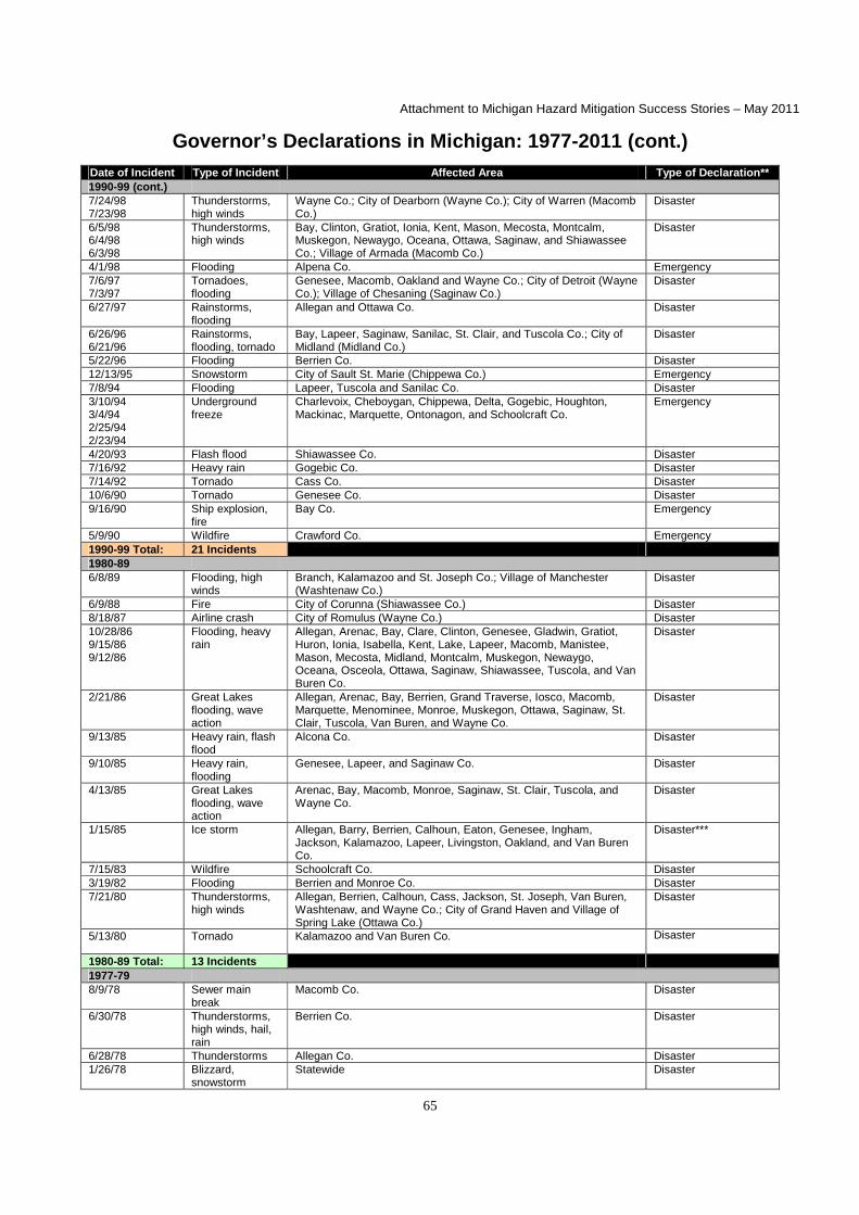
Attachment to Michigan Hazard Mitigation Success Stories – May 2011
65
Governor’s Declarations in Michigan: 1977-2011 (cont.)
Date of Incident Type of Incident Affected Area Type of Declaration** 1990-99 (cont.) 7/24/98 7/23/98
Thunderstorms, high winds
Wayne Co.; City of Dearborn (Wayne Co.); City of Warren (Macomb Co.)
Disaster
6/5/98 6/4/98 6/3/98
Thunderstorms, high winds
Bay, Clinton, Gratiot, Ionia, Kent, Mason, Mecosta, Montcalm, Muskegon, Newaygo, Oceana, Ottawa, Saginaw, and Shiawassee Co.; Village of Armada (Macomb Co.)
Disaster
4/1/98 Flooding Alpena Co. Emergency 7/6/97 7/3/97
Tornadoes, flooding
Genesee, Macomb, Oakland and Wayne Co.; City of Detroit (Wayne Co.); Village of Chesaning (Saginaw Co.)
Disaster
6/27/97 Rainstorms, flooding
Allegan and Ottawa Co. Disaster
6/26/96 6/21/96
Rainstorms, flooding, tornado
Bay, Lapeer, Saginaw, Sanilac, St. Clair, and Tuscola Co.; City of Midland (Midland Co.)
Disaster
5/22/96 Flooding Berrien Co. Disaster 12/13/95 Snowstorm City of Sault St. Marie (Chippewa Co.) Emergency 7/8/94 Flooding Lapeer, Tuscola and Sanilac Co. Disaster 3/10/94 3/4/94 2/25/94 2/23/94
Underground freeze
Charlevoix, Cheboygan, Chippewa, Delta, Gogebic, Houghton, Mackinac, Marquette, Ontonagon, and Schoolcraft Co.
Emergency
4/20/93 Flash flood Shiawassee Co. Disaster 7/16/92 Heavy rain Gogebic Co. Disaster 7/14/92 Tornado Cass Co. Disaster 10/6/90 Tornado Genesee Co. Disaster 9/16/90 Ship explosion,
fire Bay Co. Emergency
5/9/90 Wildfire Crawford Co. Emergency 1990-99 Total: 21 Incidents 1980-89 6/8/89 Flooding, high
winds Branch, Kalamazoo and St. Joseph Co.; Village of Manchester (Washtenaw Co.)
Disaster
6/9/88 Fire City of Corunna (Shiawassee Co.) Disaster 8/18/87 Airline crash City of Romulus (Wayne Co.) Disaster 10/28/86 9/15/86 9/12/86
Flooding, heavy rain
Allegan, Arenac, Bay, Clare, Clinton, Genesee, Gladwin, Gratiot, Huron, Ionia, Isabella, Kent, Lake, Lapeer, Macomb, Manistee, Mason, Mecosta, Midland, Montcalm, Muskegon, Newaygo, Oceana, Osceola, Ottawa, Saginaw, Shiawassee, Tuscola, and Van Buren Co.
Disaster
2/21/86 Great Lakes flooding, wave action
Allegan, Arenac, Bay, Berrien, Grand Traverse, Iosco, Macomb, Marquette, Menominee, Monroe, Muskegon, Ottawa, Saginaw, St. Clair, Tuscola, Van Buren, and Wayne Co.
Disaster
9/13/85 Heavy rain, flash flood
Alcona Co. Disaster
9/10/85 Heavy rain, flooding
Genesee, Lapeer, and Saginaw Co. Disaster
4/13/85 Great Lakes flooding, wave action
Arenac, Bay, Macomb, Monroe, Saginaw, St. Clair, Tuscola, and Wayne Co.
Disaster
1/15/85 Ice storm Allegan, Barry, Berrien, Calhoun, Eaton, Genesee, Ingham, Jackson, Kalamazoo, Lapeer, Livingston, Oakland, and Van Buren Co.
Disaster***
7/15/83 Wildfire Schoolcraft Co. Disaster 3/19/82 Flooding Berrien and Monroe Co. Disaster 7/21/80 Thunderstorms,
high winds Allegan, Berrien, Calhoun, Cass, Jackson, St. Joseph, Van Buren, Washtenaw, and Wayne Co.; City of Grand Haven and Village of Spring Lake (Ottawa Co.)
Disaster
5/13/80 Tornado Kalamazoo and Van Buren Co. Disaster
1980-89 Total: 13 Incidents 1977-79 8/9/78 Sewer main
break Macomb Co. Disaster
6/30/78 Thunderstorms, high winds, hail, rain
Berrien Co. Disaster
6/28/78 Thunderstorms Allegan Co. Disaster 1/26/78 Blizzard,
snowstorm Statewide Disaster

Attachment to Michigan Hazard Mitigation Success Stories – May 2011
66
Governor’s Declarations in Michigan: 1977-2011 (cont.)
Date of Incident Type of Incident Affected Area Type of Declaration** 1977-79 (cont.) 12/10/77 Snowstorm City of Hamtramck (Wayne Co.) Disaster 4/6/77 Tornado, high
winds Clinton, Eaton, Kalamazoo, and Livingston Co. Disaster
1/28/77 Blizzard Allegan, Barry, Berrien, Cass, Chippewa, Eaton, Hillsdale, Ionia, Muskegon, Newaygo, Oceana, Ottawa, Sanilac, Shiawassee, and Van Buren Co.
Disaster
1977-79 Total: 7 Incidents
Totals for 1977-2011
61 Incidents
39 Disaster Declarations; 22 Emergency Declarations
Notes
**Declarations since 1977 were issued under 1976 PA 390, as amended (Michigan Emergency Management Act). ***A "State of Emergency" was also declared for this incident under 1945 PA 302 (Emergency Powers of Governor Act). +Some incidents have resulted in multiple declarations for the same incident (each jurisdiction declared separately). These are counted as one declaration only for the purposes of this list.
Frequency Distribution of Governor’s Declarations in Michigan: 1977-2011*
JAN FEB MAR APR MAY JUNE JULY AUG SEPT OCT NOV DEC TOTAL
4 3 2 6 5 11 11 6 8 2 0 3 61 7% 5% 3% 10% 8% 18% 18% 10% 13% 3% 0% 5% 100%
Notes
*For the declaration date, not the incident period. Percentages may not add up to 100% due to rounding.
Governor’s and Presidential Declarations by County: 1953-2011*
Jurisdiction # of Governor’s
Declarations
Dates** # of Presidential Declarations
Dates**
COUNTIES
Alcona County 3 9/05; 9/85; 1/78 4 9/05; 1/99; 9/85; 1/78 Alger County 2 9/05; 1/78 2 9/05; 1/78 Allegan County 10 6/08; 9/05; 6/97; 9/86; 2/86; 1/85;
7/80; 6/78; 1/78; 1/77 13 7/08; 9/05; 1/01; 1/99; 9/86; 7/80;
1/78; 1/77; 3/76; 9/75; 4/75; 4/72; 4/65
Alpena County 3 9/05; 4/98; 1/78 2 9/05; 1/78 Antrim County 2 9/05; 1/78 2 9/05; 1/78 Arenac County 6 9/05; 6/04; 9/86; 2/86; 4/85; 1/78 6 9/05; 1/99; 9/86; 1/78; 4/73; 12/72 Baraga County 3 9/05; 4/02; 1/78 3 9/05; 5/02; 1/78 Barry County 5 9/05; 6/04; 1/85; 1/78; 1/77 10 7/08; 9/05; 6/04; 1/01; 1/99; 1/78;
1/77; 4/75; 4/72; 4/65 Bay County 8 9/05; 6/98; 6/96; 9/90; 9/86; 2/86;
4/85; 1/78 10 9/05; 1/01; 6/98; 7/96; 9/86; 1/78;
3/76; 4/73; 12/72; 4/65 Benzie County 2 9/05; 1/78 3 9/05; 1/78; 4/56 Berrien County 10 9/05; 6/04; 5/96; 2/86; 1/85; 3/82;
7/80; 6/78; 1/78; 1/77 11 9/05; 6/04; 1/01; 1/99; 3/82; 7/80;
1/78; 1/77; 4/75; 4/73; 12/72 Branch County 3 9/05; 6/89; 1/78 4 9/05; 1/01; 1/78; 4/65 Calhoun County 6 5/11; 7/10; 9/05; 1/85; 7/80; 1/78 7 9/05; 8/03; 1/01; 7/80; 1/78; 4/75;
4/72 Cass County 6 9/05; 6/04; 7/92; 7/80; 1/78; 1/77 7 9/05; 6/04; 1/01; 1/99; 7/80; 1/78;
1/77 Charlevoix County 3 9/05; 3/94; 1/78 3 9/05; 5/94; 1/78 Cheboygan County 3 9/05; 3/94; 1/78 3 9/05; 5/94; 1/78

Attachment to Michigan Hazard Mitigation Success Stories – May 2011
67
Governor’s and Presidential Declarations by County: 1953-2011* (cont.)
Jurisdiction # of
Governor’s Declarations
Dates** # of Presidential Declarations
Dates**
COUNTIES (cont.)
Chippewa County 4 9/05; 3/94; 1/78; 1/77 4 9/05; 5/94; 1/78; 1/77 Clare County 3 9/05; 9/86; 1/78 6 9/05; 1/01; 9/86; 1/78; 3/76; 9/75 Clinton County 5 9/05; 6/98; 9/86; 1/78; 4/77 9 9/05; 1/01; 6/98; 9/86; 1/78; 3/76;
4/75; 4/72; 4/65 Crawford County 3 9/05; 5/90; 1/78 4 9/05; 1/99; 1/78; 4/75 Delta County 3 9/05; 3/94; 1/78 3 9/05; 5/94; 1/78 Dickinson County 3 9/05; 8/99; 1/78 2 9/05; 1/78 Eaton County 6 6/08; 9/05; 1/85; 1/78; 4/77; 1/77 9 7/08; 9/05; 6/04; 8/03; 1/01; 1/78;
4/75; 4/72; 4/65 Emmet County 3 9/05; 12/01; 1/78 2 9/05; 1/78 Genesee County 10 9/05; 6/04; 4/04; 3/01; 7/97; 10/90;
9/86; 9/85; 1/85; 1/78 12 9/05; 6/04; 8/03; 1/01; 7/97; 9/86;
9/85; 1/78; 3/76; 9/75; 4/75; 6/53 Gladwin County 4 9/05; 6/04; 9/86; 1/78 6 9/05; 6/04; 1/01; 9/86; 1/78; 3/76 Gogebic County 4 9/05; 2/94; 7/92; 1/78 4 9/05; 5/02; 5/94; 1/78 Gd. Traverse County 3 9/05; 2/86; 1/78 2 9/05; 1/78 Gratiot County 4 9/05; 6/98; 9/86; 1/78 8 9/05; 1/01; 6/98; 9/86; 1/78; 3/76;
4/75; 4/65 Hillsdale County 3 9/05; 1/78; 1/77 7 9/05; 8/03; 1/01; 1/78; 1/77; 4/74;
4/65 Houghton County 4 9/05; 4/02; 2/94; 1/78 4 9/05; 5/02; 5/94; 1/78 Huron County 3 9/05; 9/86; 1/78 5 9/05; 1/01; 9/86; 1/78; 4/73 Ingham County 5 9/05; 6/04; 4/04; 1/85; 1/78 9 7/08; 9/05; 6/04; 8/03; 1/01; 1/78;
9/75; 4/75; 4/72 Ionia County 6 9/05; 6/04; 6/98; 9/86; 1/78; 1/77 10 9/05; 6/04; 1/01; 1/99; 6/98; 9/86;
1/78; 3/76; 4/75; 4/72 Iosco County 3 9/05; 2/86; 1/78 7 9/05; 1/99; 9/85; 1/78; 4/73; 12/72;
6/53 Iron County 3 9/05; 5/02; 1/78 3 9/05; 5/02; 1/78 Isabella County 3 9/05; 9/86; 1/78 6 9/05; 1/01; 9/86; 1/78; 3/76; 9/75 Jackson County 6 9/05; 6/04; 4/04; 1/85; 7/80; 1/78 8 9/05; 6/04; 1/01; 1/99; 7/80; 1/78;
3/76; 4/72 Kalamazoo County 7 9/05; 10/01; 6/89; 1/85; 5/80; 1/78;
4/77 10 9/05; 8/03; 1/01; 1/99; 5/80; 1/78;
1/77; 4/75; 4/72; 4/65 Kalkaska County 2 9/05; 1/78 2 9/05; 1/78 Kent County 5 9/05; 6/04; 6/98; 9/86; 1/78 11 9/05; 6/04; 1/01; 1/99; 6/98; 9/86;
1/78; 1/77; 3/76; 4/75; 4/65 Keweenaw County 2 9/05; 1/78 2 9/05; 1/78 Lake County 4 6/08; 9/05; 9/86; 1/78 4 7/08; 9/05; 9/86; 1/78 Lapeer County 8 9/05; 4/04; 6/96; 7/94; 9/86; 9/85;
1/85; 1/78 9 9/05; 8/03; 1/01; 7/96; 9/86; 9/85;
1/78; 3/76; 4/75 Leelanau County 2 9/05; 1/78 3 9/05; 1/78; 4/56 Lenawee County 2 9/05; 1/78 4 9/05; 1/99; 1/78; 4/65 Livingston County 6 9/05; 6/04; 4/04; 1/85; 1/78; 4/77 6 9/05; 6/04; 8/03; 1/01; 1/78; 4/75 Luce County 3 8/07; 9/05; 1/78 2 9/05; 1/78 Mackinac County 3 9/05; 2/94; 1/78 3 9/05; 5/94; 1/78 Macomb County 10 9/05; 6/04; 4/04; 8/03; 7/97; 9/86;
2/86; 4/85; 8/78; 1/78 13 9/05; 6/04; 8/03; 1/01; 1/99; 7/98;
7/97; 9/86; 1/78; 3/76; 4/75; 4/73; 12/72
Manistee County 4 6/08; 9/05; 9/86; 1/78 5 7/08; 9/05; 9/86; 1/78; 4/56 Marquette County 5 9/05; 4/02; 2/94; 2/86; 1/78 5 9/05; 5/02; 1/99; 5/94; 1/78 Mason County 5 6/08; 9/05; 6/98; 9/86; 1/78 5 7/08; 9/05; 6/98; 9/86; 1/78 Mecosta County 5 9/05; 6/04; 6/98; 9/86; 1/78 8 9/05; 6/04; 1/01; 1/99; 9/86; 1/78;
3/76; 9/75 Menominee County 3 9/05; 2/86; 1/78 3 9/05; 1/78; 4/73 Midland County 3 9/05; 2/86; 1/78 7 9/05; 1/01; 7/96; 9/86; 1/78; 3/76;
9/75 Missaukee County 2 9/05; 1/78 3 7/08; 9/05; 1/78 Monroe County 8 6/10; 9/05; 4/04; 8/03; 2/86; 4/85;
3/82; 1/78 10 9/05; 8/03; 1/99; 3/82; 1/78; 1/77;
4/73; 12/72; 4/65; 6/53 Montcalm County 5 2/06; 9/05; 6/98; 9/86; 1/78 8 9/05; 1/01; 6/98; 9/86; 1/78; 3/76;
9/75; 4/65

Attachment to Michigan Hazard Mitigation Success Stories – May 2011
68
Governor’s and Presidential Declarations by County: 1953-2011* (cont.)
Jurisdiction # of
Governor’s Declarations
Dates** # of Presidential Declarations
Dates**
COUNTIES (cont.)
Montmorency County
2 9/05; 1/78 3 9/05; 1/99; 1/78
Muskegon County 6 9/05; 6/98; 9/86; 2/86; 1/78; 1/77 10 9/05; 6/04; 1/01; 1/99; 6/98; 9/86; 1/78; 1/77; 3/76; 9/75
Newaygo County 6 9/05; 6/04; 6/98; 9/86; 1/78; 1/77 8 9/05; 1/99; 6/98; 9/86; 1/78; 1/77; 3/76; 9/75
Oakland County 8 7/09; 9/05; 6/04; 4/04; 8/03; 7/97; 1/85; 1/78
10 9/05; 6/04; 8/03; 1/01; 10/00; 1/99; 7/97; 1/78; 3/76; 4/75
Oceana County 5 9/05; 6/98; 9/86; 1/78; 1/77 8 9/05; 1/99; 6/98; 9/86; 1/78; 1/77; 3/76; 9/75
Ogemaw County 2 9/05; 1/78 3 9/05; 1/99; 1/78 Ontonagon County 4 9/05; 4/02; 2/94; 1/78 4 9/05; 5/02; 5/94; 1/78 Osceola County 4 6/08; 9/05; 9/86; 1/78 8 7/08; 9/05; 1/01; 1/99; 9/86; 1/78;
3/76; 9/75 Oscoda County 4 7/06; 9/05; 7/99; 1/78 3 9/05; 1/99; 1/78 Otsego County 3 9/05; 9/98; 1/78 3 9/05; 1/99; 1/78 Ottawa County 9 6/08; 9/05; 6/04; 6/98; 6/97; 9/86;
2/86; 1/78; 1/77 15 7/08; 9/05; 6/04; 1/01; 1/99; 6/98;
9/86; 7/80; 1/78; 1/77; 3/76; 9/75; 4/75; 4/65; 4/56
Presque Isle County 2 9/05; 1/78 2 9/05; 1/78 Roscommon County 2 9/05; 1/78 3 9/05; 1/78; 3/76 Saginaw County 9 9/05; 6/04; 6/98; 6/96; 9/86; 2/86;
9/85; 4/85; 1/78 14 7/08; 9/05; 6/04; 1/01; 6/98; 7/97;
7/96; 9/86; 9/85; 1/78; 3/76; 9/75; 4/75; 4/73
St. Clair County 6 9/05; 6/04; 6/96; 2/86; 4/85; 1/78 11 9/05; 6/04; 8/03; 1/01; 7/96; 1/78; 3/76; 4/75; 4/73; 12/72; 5/53
St. Joseph County 5 9/05; 6/04; 6/89; 7/80; 1/78 7 9/05; 6/04; 1/01; 1/99; 7/80; 1/78; 1/77
Sanilac County 6 9/05; 6/04; 6/96; 7/94; 1/78; 1/77 8 9/05; 6/04; 1/01; 7/96; 9/86; 1/78; 3/76; 4/73
Schoolcraft County 4 9/05; 2/94; 7/83; 1/78 3 9/05; 5/94; 1/78 Shiawassee County 7 9/05; 6/04; 6/98; 4/93; 9/86; 1/78;
1/77 11 9/05; 6/04; 1/01; 6/98; 9/86; 9/85;
1/78; 3/76; 9/75; 4/75; 4/65 Tuscola County 6 9/05; 7/94; 9/86; 2/86; 4/85; 1/78 8 9/05; 1/01; 7/96; 9/86; 1/78; 3/76;
4/73; 12/72 Van Buren County 9 9/05; 6/04; 9/86; 2/86; 1/85; 7/80;
5/80; 1/78; 1/77 10 9/05; 1/01; 1/99; 9/86; 7/80; 5/80;
1/78; 1/77; 4/75; 4/73 Washtenaw County 5 9/05; 4/04; 8/03; 7/80; 1/78 8 9/05; 6/04; 8/03; 1/01; 1/99; 7/80;
1/78; 4/65 Wayne County 11 9/05; 6/04; 4/04; 8/03; 9/00; 7/98;
7/97; 2/86; 4/85; 7/80; 1/78 12 9/05; 6/04; 8/03; 10/00; 1/99; 7/98;
7/97; 7/80; 1/78; 3/76; 4/73; 12/72
Wexford County 3 6/08; 9/05; 1/78 3 7/08; 9/05; 1/78
THE REMAINDER OF THIS PAGE INTENTIONALLY LEFT BLANK.

Attachment to Michigan Hazard Mitigation Success Stories – May 2011
69
Governor’s Declarations by Municipality: 1977-2011
Jurisdiction # of
Governor’s Declarations
Dates*
MUNICIPALITIES
City of Battle Creek (Calhoun County) 1 5/11 City of Saginaw (Saginaw County) 1 6/08 City of Lansing (Ingham County) 1 6/08 City of Fenton (Genesee County) 1 8/07 City of Allen Park (Wayne County) 1 4/04 City of Ann Arbor (Washtenaw County) 1 4/04 City of Birmingham (Oakland County) 1 4/04 City of Dearborn Heights (Wayne County) 1 4/04 City of Fraser (Macomb County) 1 4/04 City of Livonia (Wayne County) 1 4/04 City of River Rouge (Wayne County) 1 4/04 City of Southfield (Oakland County) 1 4/04 City of Sterling Heights (Macomb County) 1 4/04 City of Trenton (Wayne County) 1 4/04 City of Wayne (Wayne County) 1 4/04 Bloomfield Township (Oakland County) 1 4/04 Canton Township (Wayne County) 1 4/04 Charter Township of Plymouth (Wayne County) 1 4/04 Lathrup Village (Oakland County) 1 4/04 Negaunee Township (Marquette County) 1 5/03 Marquette Township (Marquette County) 1 5/03 City of Ironwood (Gogebic County) 1 4/02 Blackman Township (Jackson County) 1 6/00 City of Niles (Berrien County) 1 9/98 City of Warren (Macomb County) 2 4/04; 7/98 City of Dearborn (Wayne County) 2 4/04; 7/98 Village of Armada (Macomb County) 1 6/98 City of Detroit (Wayne County) 3 4/04; 1/99; 7/97 Village of Chesaning (Saginaw County) 1 7/97 City of Midland (Midland County) 1 6/96 City of Sault Ste. Marie (Chippewa County) 1 12/95 City of Marquette (Marquette County) 2 5/03; 2/94 City of Negaunee (Marquette County) 1 2/94 City of Ishpeming (Marquette County) 1 2/94 Powell Township (Marquette County) 1 2/94 Village of Manchester (Washtenaw County) 1 6/89 City of Corunna (Shiawassee County) 1 6/88 City of Romulus (Wayne County) 2 4/04; 8/87 City of Grand Haven (Ottawa County) 1 7/80 Village of Spring Lake (Ottawa County) 1 7/80 City of Hamtramck Wayne County) 1 12/77
Notes
*Many municipal declarations issued concurrent with a county declaration.

Attachment to Michigan Hazard Mitigation Success Stories – May 2011
70