1
UPs23 Southern Mesic Prairie Class UPs23a Mesic Prairie (Southern) Type - Wet-mesic to dry-mesic prairies on level to undulating terrain (slopes generally less than 10%). The soils are derived from glacial till or outwash and are moderately well drained. Species composition varies greatly between sites differing in soil moisture but is generally dominated by some combination of the grasses big bluestem, prairie dropseed, Indian grass, little bluestem, and switch grass; in the more wet-mesic areas, prairie cordgrass is common. Other typical graminoids include Leiberg’s panic grass, porcupine grass, slender wheatgrass, Kalm’s brome, and Mead’s sedge. Typical forbs include Maximilian’s sunflower, golden alexanders, heart-leaved alexanders, northern plains blazing star, great blazing star, smooth aster, wood lily, purple prairie clover, northern bedstraw, black-eyed Susan, Virginia mountain mint, and white camass. Approximate area mapped: 430 acres WETLAND GRASSLANDS, SHRUBLANDS, AND MARSHES Open Rich Peatland System OPn92 Northern Rich Fen (Basin) Class OPn92b Graminoid - Sphagnum Rich Fen (Basin) Type - Open wetlands found on saturated sphagnum peat in small, nutrient-poor basins that are relatively isolated from runoff. This habitat has a continuous mat of sphagnum mosses surrounded by a narrow open water moat. Shrubs, such as bog birch, slender willow, and bog willow are often scattered across the community but they do not dominate. Sedges typically dominate the herbaceous layer, with wiregrass sedge, creeping sedge, interior sedge, cotton grass, and lake sedge all abundant. Other common herbs include kidney- leaved violet, round-leaved sundew, marsh fern, marsh cinquefoil, broad-leaved arrowhead, tufted loosestrife, and Labrador bedstraw. In some sites small cranberry is common. In the best examples, the innermost part of the fen is most typically dominated by sphagnum moss with creeping sedge, cottongrass and other indicators such as small cranberry and round-leaved sundew. In these sites, wiregrass sedge is confined to the outer edges of the fen, presumably where there is more mineral input. Some fens with more mineral inputs may have wiregrass sedge throughout and a wide moat on the edges. Lake sedge is most often on the outer parts of the wiregrass zone, with tussock sedge. Approximate area mapped: 54 acres willow, Bebb’s willow, red-osier dogwood, and bog birch. Additional graminoids present include tussock sedge, clustered muhly grass, and northern reedgrass. Typical forbs include spotted Joe pye weed, common boneset, cut-leaved bugleweed, Labrador bedstraw, and swamp lousewort. Marsh fern, marsh cinquefoil, and great water dock also common. In some cases, this community can be a floating mat of sedges and non-sphagnum mosses. Approximate area mapped: 222 acres OPp93 Prairie Extremely Rich Fen Class OPp93b Calcareous Fen (Southwestern) Type - Open wetlands on peat that is continuously saturated by cold, calcium-rich, oxygen-poor, upwelling groundwater. Typically found on slopes of hills formed in calcareous sand and gravel. Small, marly pools often occur where groundwater discharge is greatest. Dominated by graminoids including hair-like beak rush, sterile sedge, big bluestem, clustered muhly grass, mat muhly grass, northern reedgrass, wiregrass sedge, and aquatic sedge; patches of hardstem bulrush and three-square bulrush are often present. Low to medium height shrubs can be common, including sage-leaved willow and bog birch. Typical forbs include American grass-of-Parnassus, seaside arrow-grass, marsh arrow-grass, Kalm’s lobelia, bog aster, lesser fringed gentian, and greater fringed gentian. Approximate area mapped: 6 acres Wet Meadow/Carr System WMn82 Northern wet meadow/Carr Class WMn82a Willow - Dogwood Shrub Swamp Type - Shrub-dominated wetlands on saturated mineral or shallow organic soils in shallow basins. Dense, often tall shrub layer dominated by a mix of pussy willow, Bebb’s willow, slender willow and red-osier dogwood. Ground layer consists of common wetland species such as narrow-leaved cattail, hybrid cattail, lake sedge, prairie sedge, aquatic sedge, northern reedgrass, bluejoint, marsh bellflower, tussock sedge, marsh cinquefoil, tufted loosestrife, great water dock, bulb-bearing water hemlock, and water smartweed. Approximate area mapped: 1,014 acres WMn82b Sedge Meadow Type - Wet, sedge dominated communities in poorly drained, organic soils in shallow depressions on glacial till or outwash. Seasonally flooded with a persistent high water table above the ground surface for much of the growing season. Dominants are one or a combination of the following graminoids: lake sedge, aquatic sedge, beaked sedge, bluejoint, tussock sedge, Hayden’s sedge, and northern reed-grass. Characteristic forbs include spotted Joe-Pye weed, common boneset, water smartweed, marsh cinquefoil, tufted loosestrife, red- stemmed aster, cut-leaved bugleweed, common mint, marsh skullcap, swamp milkweed, woundwort, labrador bedstraw, and great water dock. Shrubs are mostly in small clumps (accounting for less than 30% cover) and commonly include OPp91 Prairie Rich Fen Class OPp91a Rich Fen (Mineral Soil) Type - Open wetlands located on saturated mucky soil over mineral soil in shallow basins in rolling terrain; may also be present as inclusions in large shallow wetlands with circumneutral surface water. Dominated by fine-bladed sedges, most commonly wiregrass sedge. Shrubs can be present and often abundant. Common species include slender willow, pussy slender willow, Bebb’s willow, and pussy willow. Approximate area mapped: 695 acres WMs83 Southern Seepage Meadow/Carr Class WMs83a Seepage Meadow/Carr Type - Wet, shrub dominated wetlands on saturated mineral or thin organic soils on gently sloping terrain. Upwelling groundwater maintains saturated conditions but flooding is uncommon. Dense shrub cover composed of a mix of pussy willow, slender willow, and red-osier dogwood, and bog birch. Ground cover is similar to the shrub swamp community with sedges being the most common species, particularly prairie sedge and tussock sedge. Often contains many plant species seen in calcareous seepage fens. Approximate area mapped: 29 acres Marsh System MRp83 Prairie Mixed Cattail Marsh Class MRp83b Cattail Marsh (Prairie) Type - Emergent marsh communities typically dominated by nearly pure stands of cattails (normally narrow-leaved cattail or hybrid cattail). Present on floating mats along shorelines in lakes, ponds, and river backwaters, or rooted in mineral soil in shallow wetland basins. No effort was made to map all the cattail marshes in the county. Those that are mapped join other mapped areas of high quality native plant communities or they are particularly large. Approximate area mapped: 2,937 acres MRp93 Prairie Bulrush-Arrowhead Marsh Class MRp93c Arrowhead Marsh (Prairie) Type - Open, shallow-basin wetlands that have standing water present throughout the year. Typically associated with lakes or ponds. Found on mineral or shallow organic soils on glacial till, outwash, or alluvium. Dominated by persistent emergent vegetation often in a mosaic of single species patches. In some cases they are dominated almost exclusively by wild rice. In other cases, there is a mixture of species including giant bur reed, bluejoint, rice cut grass, broad-leaved arrowhead, water plantain, and water parsnip. Approximate area mapped: 30 acres Lowland Prairie System WPs54 Southern Wet Prairie Class WPs54b Wet Prairie (Southern) Type - Nearly level prairies on mineral soil derived from glacial till or glacial outwash deposits. Occurs in shallow depressions where drainage is impeded, but flooding is temporary, and the water table is below the rooting zone for most of growing season. Dominated mostly by the grasses prairie cordgrass, big bluestem, switchgrass, northern reedgrass, Baltic rush, and mat muhly. Sedges are also important, especially Sartwell’s sedge, Buxbaum’s sedge, and woolly sedge. Typical forbs include great blazing star, grass-leaved goldenrod, bottle gentian, swamp milkweed, spotted water hemlock, autumn sneezeweed, giant sunflower, Riddell’s goldenrod, prairie loosestrife, New England aster, and great lobelia. Shrubs are sometimes common but have less than 30% cover; typical species include pussy willow, Bebb's willow, slender willow, and red osier dogwood. Approximate area mapped: 35 acres hackberry with small pockets of black ash in low wet spots. American elm dominants the canopy in some tracts but in others, it is present mostly as standing dead snags. Hackberry and American elm dominate the understory. The shrub layer is mostly sparse, with prickly gooseberry, Missouri gooseberry, prickly ash and common elder being the most frequent species. Ground layer commonly includes Virginia waterleaf, cleavers, Dutchman’s breeches and false rue anemone in the spring and becomes dominated by wood nettle throughout the summer. Approximate area mapped: 264 acres WETLAND FORESTS Wet Forest System WFs55 Southern Wet Aspen Forest Class WFs55a Lowland Aspen Forest Type - Wet to wet-mesic woodland in poorly drained, shallow depressions on mineral or organic soil, often on former wet prairie or wet meadow where fire has been excluded. Interrupted canopy cover dominated by quaking aspen. Shrub layer is often dense and composed of pussy willow, Bebb’s willow and red-osier dogwood. The ground layer is similar to wet prairie or wet meadow but may also contain some species common to mesic forests. Approximate area mapped: 16 acres UPLAND GRASSLANDS, SHRUBLANDS, AND SPARSE VEGETATION Upland Prairie System UPs13 Southern Dry Prairie Class UPs13b Dry Sand - Gravel Prairie (Southern) Type - Dry prairies on excessively drained soils derived from sandy and gravelly glacial ice contact deposits, such as eskers and kames, on gently to steeply sloping sites. Typically dominated by the grasses little bluestem, porcupine grass, and side-oats grama; Wilcox’s panic grass and blue grama are usually present in lesser amounts. Sand reed-grass, hairy grama, and Junegrass are prevalent in the most xeric sandy areas. Eastern red cedar, leadplant, and prairie rose are common shrubs. Common forbs include hoary frostweed, downy paintbrush, sage wormwood, plantain-leaved pussytoes, harebell, dotted blazing star, rough blazing star, prairie milk vetch, ground plum, purple prairie clover, hoary puccoon, prairie turnip, heath aster, silky aster, skyblue aster, Flodman’s thistle, prairie golden-aster, and northern bedstraw. Approximate area mapped: 1,591 acres ative plant communities are groups of native plants that interact with each other and with their environment in ways not greatly altered by modern human activity or by introduced organisms. These groups of native species form recognizable units, such as oak forest, prairie, or marsh, that tend to repeat over space and time. The classification and description of native plant communities depicted on this map are based on Minnesota’s Native Plant Community Classification (version 2.0). This hierarchical classification uses vegetation composition, hydrology, landforms, soils, and natural disturbance regimes to categorize plant communities first into System Groups, followed by Systems, Classes, Types, and Subtypes. The native plant communities of Kandiyohi County are mapped and described at the Type level. The Minnesota County Biological Survey located areas of native plant communities in Kandiyohi County in 2000-2002 using aerial photo interpretation followed by field surveys of selected sites. The description and approximate acreage of each native plant community are based on the results of the Survey. White areas on the map represent land where modern human activities such as farming, overgrazing, wetland drainage, recent logging, and residential and commercial development have destroyed or greatly altered the natural vegetation. Higher quality native plant communities covered approximately 14,263 acres (2.6% of the County) at the time of the Survey. UPLAND FORESTS AND WOODLANDS Fire-Dependent Forest/Woodland System FDs37 Southern Dry-Mesic Oak-(Maple) Woodland Class FDs37b Pin Oak - Bur Oak Woodland Type - Woodlands on well-drained soils derived from glacial till or supraglacial deposits, often on south to west facing slopes. The tree canopy consists of open-grown bur oak, with lesser amounts of northern pin oak, paper birch, eastern red cedar, and quaking aspen. The shrub layer is often dense with American hazelnut, chokecherry, gray dogwood, prickly ash, and downy arrowwood. Ground layer consists of moderately shade-tolerant species including hog peanut, pointed-leaved tick trefoil, and Pennsylvania sedge. Prairie species are often present in small openings. Most stands have succeeded from oak savanna following fire suppression since European settlement. Approximate area mapped: 143 acres Mesic Hardwood Forest System MHs38 Southern Mesic Oak-Basswood Forest Class MHs38b Basswood - Bur Oak - (Green Ash) Forest Type - Mesic forests on moist soils derived from glacial till or supraglacial deposits. On rolling, hummocky terrain or level ground. Canopy dominated mostly by northern red oak and basswood, with lesser amounts of bur oak and green ash. Sugar maple can be occasional although it is generally absent from most stands due to fires in the prairie region prior to European settlement. Subcanopy is well-developed and composed of ironwood, basswood, green ash, red elm, American elm, and occasionally sugar maple. Shrub layer typically consists of prickly ash, prickly gooseberry, Missouri gooseberry, pagoda dogwood, and common elder. Ground layer includes Dutchman’s breeches, jack-in-the-pulpit, blue cohosh, nodding trillium, bloodroot, wild sarsaparilla, common false Solomon’s seal, Clayton’s sweet cicely, pointed- leaved tick trefoil, mountain rice-grass, Pennsylvania sedge, lopseed, zigzag goldenrod, large-flowered bellwort, Virginia waterleaf, and long-stalked sedge. In some sites, this community also contains inclusions of wet-mesic hardwood forest at the bottom of steep north facing slopes. These areas have a similar canopy composition but the herbaceous layer is heavily dominated by wood nettle. Approximate area mapped: 6,793 acres MHs49 Southern Wet-Mesic Hardwood Forest Class MHs49a Elm - Basswood - Black Ash - (Hackberry) Forest Type - Wet-mesic forests on clay loam soils on level ground along creeks and on lake peninsulas. Canopy dominated by a combination of American elm, green ash, basswood and 0 50 100 25 Miles ¯ OTHER MAPPED FEATURES Rivers, Streams, and Ditches Lakes and Open Water Secondary Roads Railroads Primary Roads RARE SPECIES OF SPECIAL INTEREST [ Rare Plants X Rare Animals Colonial Waterbird Nesting " Willmar Atwater Lake Lillian Blomkest Prinsburg Raymond Pennock Sunburg New London Spicer Green Lake Foot Lake Willmar Lake Eagle Lake Long Lake Nest Lake Lake Florida Norway Lake Mud Lake Lake Calhoun Wagonga Lake Big Kandiyohi Lake Little Kandiyohi Lake Minnetaga Lake Lake Elizabeth Lake Lillian Diamond Lake Andrew Lake Green Lake R35W OPn92b WMn82b MRp93c OPp93b OPn92b t u 71 Solomon Lake West Solomon Lake MRp83b OPp93b Kandiyohi OPn92b [ [ MRp83b MRp83b OPn92b UPs23a UPs13b UPs13b t u 12 T123N T119N t u 71 t u 12 " ) 23 " ) 104 " ) 9 " ) 7 " ) 4 " ) 55 " ) 40 " ) 294 " ) 23 Q R 36 Q R 30 Q R 2 Q R 9 Q R 40 Q R 4 Q R 44 Q R 3 Q R 8 Q R 1 Q R 5 Q R 17 Q R 27 Q R 19 Q R 16 Q R 7 Q R 29 Q R 35 Q R 26 Q R 15 Q R 33 Q R 34 Q R 10 Q R 31 Q R 14 Q R 11 Q R 23 Q R 28 Q R 18 Q R 6 Q R 25 Q R 13 Q R 41 Q R 48 Q R 32 Q R 38 Q R 42 Q R 1 Q R 1 Q R 20 Q R 5 Q R 2 Q R 2 Q R 3 Q R 5 Q R 29 Q R 30 Q R 9 1 1 6 1 6 6 1 6 1 1 6 1 1 1 1 1 1 1 1 1 1 6 1 1 1 6 6 6 6 6 6 6 6 6 6 1 1 6 6 1 36 31 36 36 36 36 36 36 31 36 31 36 31 36 31 31 36 36 36 31 36 31 36 36 31 36 36 31 36 31 36 31 36 31 31 31 31 31 31 31 31 31 R33W R34W R36W T117N T118N T121N T120N X [ [ [ [ [ [ [ [ [ [ [ " X X X X X X [ X X X X X X X X X [ [ [ [ [ X [ X [ [ [ [ X X X X X X X X X [ [ [ [ [ [ [ [ [ [ [ [ [ [ [ X [ X X X [ [ [ [ [ [ [ [ [ X " [ [ 0 6 12 3 Miles 1:60,000 ¯ NATIVE PLANT COMMUNITIES AND RARE SPECIES IN KANDIYOHI COUNTY, MINNESOTA Minnesota County Biological Survey October 2005 MINNESOTA COUNTY BIOLOGICAL SURVEY Department of Natural Resources Division of Ecological Services 500 Lafayette Road, Box 25 St. Paul, MN 55155 (651) 296-2835 Brushland Aspen-Oak Land Brush Prairie Oak openings and barrens Bogs and Swamps Lakes (open water) Grassland Wet Prairie Prairie Upland Hardwood Forest Big Woods - Hardwoods (oak, maple, basswood, hickory) THE VEGETATION OF KANDIYOHI COUNTY AT THE TIME OF THE PUBLIC LAND SURVEY This map shows the vegetation of Kandiyohi County as interpreted by Francis J. Marschner using Public Land Survey records from 1856-1858. The legend descriptions are slightly modified from Marschner's original descriptions. *Common and scientific names of plants mentioned in the legend (scientific names follow the DNR's Minnesota Plant Database, January 2003). PLANT SPECIES LIST* Mountain rice-grass – Oryzopsis asperifolia Narrow-leaved cattail – Typha angustifolia New England aster – Aster novae-angliae Nodding trillium – Trillium cernuum Northern bedstraw – Galium boreale Northern pin oak – Quercus ellipsoidalis Northern plains blazing star – Liatris ligulistylis Northern red oak – Quercus rubra Pagoda dogwood – Cornus alternifolia Paper birch – Betula papyrifera Pennsylvania sedge – Carex pensylvanica Plantain-leaved pussytoes – Antennaria plantaginifolia Pointed-leaved tick trefoil – Desmodium glutinosum Porcupine grass – Stipa spartea Prairie cordgrass – Spartina pectinata Prairie dropseed – Sporobolus heterolepis Prairie golden aster – Heterotheca villosa Prairie loosestrife – Lysimachia quadriflora Prairie milk vetch – Astragalus adsurgens Prairie rose – Rosa arkansana Prairie sedge – Carex prairea Prairie turnip – Psoralea esculenta Prickly ash – Zanthoxylum americana Prickly gooseberry – Ribes cynosbati Purple prairie clover – Petalostemon purpureum Pussy willow – Salix discolor Quaking aspen – Populus tremuloides Red elm – Ulmus rubra Red-osier dogwood – Cornus stolonifera Red-stemmed aster – Aster puniceus Rice cut grass – Leersia oryzoides Riddells goldenrod – Solidago riddellii Rough blazing star – Liatris aspera Round-leaved sundew – Drosera rotundifolia Sage wormwood – Artemisia frigida Sage-leaved willow – Salix candida Sand reedgrass – Calamovilfa longifolia Sartwell’s sedge – Carex sartwellii Seaside arrowgrass – Triglochin maritima Side-oats grama – Bouteloua curtipendula Silky aster – Aster sericeus Skyblue aster – Aster oolentangiensis Slender wheatgrass – Agropyron trachycaulum Slender willow Salix gracilis Small cranberry – Vaccinium oxycoccus Smooth aster – Aster laevis Spotted Joe Pye weed – Eupatorium maculatum Spotted water hemlock – Cicuta maculata Sterile sedge – Carex sterilis Sugar maple – Acer saccharum Swamp lousewort – Pedicularis lanceolata Swamp milkweed – Asclepias incarnata Switchgrass – Panicum virgatum Three-square bulrush – Scirpus pungens Tufted loosestrife – Lysimachia thyrsiflora Tussock sedge – Carex stricta Virginia mountain mint – Pycnanthemum virginiana Virginia waterleaf – Hydrophyllum virginianum Water parsnip – Sium suave Water plantain – Alisma spp. Water smartweed – Polygonum amphibium White camas – Zigadenus elegans Wilcox’s panic grass – Panicum wilcoxianum Wild rice – Zizania palustris Wild sarsaparilla – Aralia nudicaulis Wiregrass sedge – Carex lasiocarpa Wood lily – Lilium philadelphicum Wood nettle – Laportea canadensis Woolly sedge – Carex pellita Woundwort – Stachys palustris Zigzag goldenrod – Solidago flexicaulis Marsh arrowgrass – Triglochin palustris Marsh bellflower – Campanula aparinoides Marsh cinquefoil – Potentilla palustris Marsh fern – Thelypteris palustris Marsh skullcap – Scutellaria galericulata Mat muhly grass – Muhlenbergia richardsonis Maximilians sunflower – Helianthus maximiliani Mead’s sedge – Carex meadii Missouri gooseberry – Ribes missouriensis Lopseed – Phryma leptostachya American elm – Ulmus americana American grass-of Parnassus – Parnassia glauca American hazelnut – Corylus americana Aquatic sedge – Carex aquatilis Autumn sneezeweed Helenium autumnale Baltic rush – Juncus balticus Basswood – Tilia americana Beaked sedge – Carex utriculata Bebbs willow – Salix bebbiana Black ash – Fraxinus nigra Black-eyed Susan – Rudbeckia hirta Bloodroot – Sanguinaria canadensis Blue cohosh – Caulophyllum thalictroides Blue grama – Bouteloua gracilis Bog aster – Aster borealis Bog birch – Betula glandulifera Bog willow – Salix pedicellaris Bottle gentian – Gentiana andrewsii Broad-leaved arrowhead – Sagittaria latifolia Bulb-bearing water hemlock – Cicuta bulbifera Bur oak – Quercus macrocarpa Buxbaum’s sedge – Carex buxbaumii Cattails – Typha spp. Chokecherry – Prunus virginiana Clayton’s sweet cicely – Osmorhiza claytonia Clustered muhly grass – Muhlenbergia glomerata Common boneset – Eupatorium perfoliatum Common elder – Sambucus canadensis Common false Solomons seal – Smilacina racemosa Common mint – Mentha arvensis Cottongrass – Eriophorum spp. Creeping sedge – Carex chordorrhiza Cut-leaved bugleweed – Lycopus americana Dotted blazing star – Liatris punctata Downy arrowwood – Viburnum rafinesquianum Downy paintbrush – Castilleja sessiliflora Dutchman’s breeches – Dicentra cucullaria Eastern red cedar – Juniperus virginiana False rue anemone – Isopyrum biternatum Flodmans thistle – Cirsium flodmanii Cleavers – Galium aparine Giant bur reed – Sparganium eurycarpum Giant sunflower – Helianthus giganteus Golden alexanders – Zizia aurea Grass-leaved goldenrod – Euthamia graminifolia Gray dogwood – Cornus foemina ssp. racemosa Great blazing star – Liatris pycnostachya Great lobelia – Lobelia siphilitica Great water dock – Rumex orbiculatus Greater fringed aster – Gentianopsis crinita Green ash – Fraxinus pennsylvanica Ground plum – Astragalus crassicarpus Hackberry – Celtis occidentalis Harebell – Campanula rotundifolia Hair-like beak rush – Rhynchospora capillacea Hairy grama – Bouteloua hirsuta Hardstem bulrush – Scirpus acutus Hayden’s sedge – Carex haydenii Heart-leaved Alexanders – Zizia aptera Heath aster – Aster ericoides Hoary frostweed – Helianthemum bicknellii Hoary puccoon – Lithospermum canescens Hog peanut – Amphicarpaea bracteata Hybrid cattail – Typha glauca Indian grass – Sorghastrum nutans Interior sedge – Carex interior Ironwood – Ostrya virginiana Jack-in-the-pulpit – Arisaema triphyllum Junegrass – Koeleria macrantha Kalm’s Brome – Bromus kalmii Kalm’s lobelia – Lobelia kalmii Kidney-leaved violet – Viola renifolia Labrador bedstraw – Galium labradoricum Lake sedge – Carex lacustris Large-flowered bellwort – Uvularia grandiflora Leadplant – Amorpha canescens Leibergs panic grass – Panicum leibergii Lesser fringed aster – Gentianopsis procera Little bluestem – Schizachyrium scoparium Long-stalked sedge – Carex pedunculata

Native Plant Communities and Rare Species of Kandiyohi

  • Upload
    others

  • View
    5

  • Download
    0

Embed Size (px)

Citation preview

UPs23 Southern Mesic Prairie Class UPs23a Mesic Prairie (Southern) Type - Wet-mesic to dry-mesic prairies on level to undulating terrain (slopes generally less than 10%). The soils are derived from glacial till or outwash and are moderately well drained. Species composition varies greatly between sites differing in soil moisture but is generally dominated by some combination of the grasses big bluestem, prairie dropseed, Indian grass, little bluestem, and switch grass; in the more wet-mesic areas, prairie cordgrass is common. Other typical graminoids include Leiberg’s panic grass, porcupine grass, slender wheatgrass, Kalm’s brome, and Mead’s sedge. Typical forbs include Maximilian’s sunflower, golden alexanders, heart-leaved alexanders, northern plains blazing star, great blazing star, smooth aster, wood lily, purple prairie clover, northern bedstraw, black-eyed Susan, Virginia mountain mint, and white camass. Approximate area mapped: 430 acres WETLAND GRASSLANDS, SHRUBLANDS, AND MARSHES Open Rich Peatland System OPn92 Northern Rich Fen (Basin) Class OPn92b Graminoid - Sphagnum Rich Fen (Basin) Type - Open wetlands found on saturated sphagnum peat in small, nutrient-poor basins that are relatively isolated from runoff. This habitat has a continuous mat of sphagnum mosses surrounded by a narrow open water moat. Shrubs, such as bog birch, slender willow, and bog willow are often scattered across the community but they do not dominate. Sedges typically dominate the herbaceous layer, with wiregrass sedge, creeping sedge, interior sedge, cotton grass, and lake sedge all abundant. Other common herbs include kidney- leaved violet, round-leaved sundew, marsh fern, marsh cinquefoil, broad-leaved arrowhead, tufted loosestrife, and Labrador bedstraw. In some sites small cranberry is common. In the best examples, the innermost part of the fen is most typically dominated by sphagnum moss with creeping sedge, cottongrass and other indicators such as small cranberry and round-leaved sundew. In these sites, wiregrass sedge is confined to the outer edges of the fen, presumably where there is more mineral input. Some fens with more mineral inputs may have wiregrass sedge throughout and a wide moat on the edges. Lake sedge is most often on the outer parts of the wiregrass zone, with tussock sedge. Approximate area mapped: 54 acres

willow, Bebb’s willow, red-osier dogwood, and bog birch. Additional graminoids present include tussock sedge, clustered muhly grass, and northern reedgrass. Typical forbs include spotted Joe pye weed, common boneset, cut-leaved bugleweed, Labrador bedstraw, and swamp lousewort. Marsh fern, marsh cinquefoil, and great water dock also common. In some cases, this community can be a floating mat of sedges and non-sphagnum mosses. Approximate area mapped: 222 acres

OPp93 Prairie Extremely Rich Fen Class

OPp93b Calcareous Fen (Southwestern) Type - Open wetlands on peat that is continuously saturated by cold, calcium-rich, oxygen-poor, upwelling groundwater. Typically found on slopes of hills formed in calcareous sand and gravel. Small, marly pools often occur where groundwater discharge is greatest. Dominated by graminoids including hair-like beak rush, sterile sedge, big bluestem, clustered muhly grass, mat muhly grass, northern reedgrass, wiregrass sedge, and aquatic sedge; patches of hardstem bulrush and three-square bulrush are often present. Low to medium height shrubs can be common, including sage-leaved willow and bog birch. Typical forbs include American grass-of-Parnassus, seaside arrow-grass, marsh arrow-grass, Kalm’s lobelia, bog aster, lesser fringed gentian, and greater fringed gentian. Approximate area mapped: 6 acres

Wet Meadow/Carr System WMn82 Northern wet meadow/Carr Class

WMn82a Willow - Dogwood Shrub Swamp Type - Shrub-dominated wetlands on saturated mineral or shallow organic soils in shallow basins. Dense, often tall shrub layer dominated by a mix of pussy willow, Bebb’s willow, slender willow and red-osier dogwood. Ground layer consists of common wetland species such as narrow-leaved cattail, hybrid cattail, lake sedge, prairie sedge, aquatic sedge, northern reedgrass, bluejoint, marsh bellflower, tussock sedge, marsh cinquefoil, tufted loosestrife, great water dock, bulb-bearing water hemlock, and water smartweed. Approximate area mapped: 1,014 acres

WMn82b Sedge Meadow Type - Wet, sedge dominated communities in poorly drained, organic soils in shallow depressions on glacial till or outwash. Seasonally flooded with a persistent high water table above the ground surface for much of the growing season. Dominants are one or a combination of the following graminoids: lake sedge, aquatic sedge, beaked sedge, bluejoint, tussock sedge, Hayden’s sedge, and northern reed-grass. Characteristic forbs include spotted Joe-Pye weed, common boneset, water smartweed, marsh cinquefoil, tufted loosestrife, red- stemmed aster, cut-leaved bugleweed, common mint, marsh skullcap, swamp milkweed, woundwort, labrador bedstraw, and great water dock. Shrubs are mostly in small clumps (accounting for less than 30% cover) and commonly include

OPp91 Prairie Rich Fen Class OPp91a Rich Fen (Mineral Soil) Type - Open wetlands located on saturated mucky soil over mineral soil in shallow basins in rolling terrain; may also be present as inclusions in large shallow wetlands with circumneutral surface water. Dominated by fine-bladed sedges, most commonly wiregrass sedge. Shrubs can be present and often abundant. Common species include slender willow, pussy

slender willow, Bebb’s willow, and pussy willow. Approximate area mapped: 695 acres

WMs83 Southern Seepage Meadow/Carr Class

WMs83a Seepage Meadow/Carr Type - Wet, shrub dominated wetlands on saturated mineral or thin organic soils on gently sloping terrain. Upwelling groundwater maintains saturated conditions but flooding is uncommon. Dense shrub cover composed of a mix of pussy willow, slender willow, and red-osier dogwood, and bog birch. Ground cover is similar to the shrub swamp community with sedges being the most common species, particularly prairie sedge and tussock sedge. Often contains many plant species seen in calcareous seepage fens. Approximate area mapped: 29 acres

Marsh System MRp83 Prairie Mixed Cattail Marsh Class

MRp83b Cattail Marsh (Prairie) Type - Emergent marsh communities typically dominated by nearly pure stands of cattails (normally narrow-leaved cattail or hybrid cattail). Present on floating mats along shorelines in lakes, ponds, and river backwaters, or rooted in mineral soil in shallow wetland basins. No effort was made to map all the cattail marshes in the county. Those that are mapped join other mapped areas of high quality native plant communities or they are particularly large. Approximate area mapped: 2,937 acres

MRp93 Prairie Bulrush-Arrowhead Marsh Class

MRp93c Arrowhead Marsh (Prairie) Type - Open, shallow-basin wetlands that have standing water present throughout the year. Typically associated with lakes or ponds. Found on mineral or shallow organic soils on glacial till, outwash, or alluvium. Dominated by persistent emergent vegetation often in a mosaic of single species patches. In some cases they are dominated almost exclusively by wild rice. In other cases, there is a mixture of species including giant bur reed, bluejoint, rice cut grass, broad-leaved arrowhead, water plantain, and water parsnip. Approximate area mapped: 30 acres

Lowland Prairie System WPs54 Southern Wet Prairie Class WPs54b Wet Prairie (Southern) Type - Nearly level prairies on mineral soil derived from glacial till or glacial outwash deposits. Occurs in shallow depressions where drainage is impeded, but flooding is temporary, and the water table is below the rooting zone for most of growing season. Dominated mostly by the grasses prairie cordgrass, big bluestem, switchgrass, northern reedgrass, Baltic rush, and

mat muhly. Sedges are also important, especially Sartwell’s sedge, Buxbaum’s sedge, and woolly sedge. Typical forbs include great blazing star, grass-leaved goldenrod, bottle gentian, swamp milkweed, spotted water hemlock, autumn sneezeweed, giant sunflower, Riddell’s goldenrod, prairie loosestrife, New England aster, and great lobelia. Shrubs are sometimes common but have less than 30% cover; typical species include pussy willow, Bebb's willow, slender willow, and red osier dogwood. Approximate area mapped: 35 acres

hackberry with small pockets of black ash in low wet spots. American elm dominants the canopy in some tracts but in others, it is present mostly as standing dead snags. Hackberry and American elm dominate the understory. The shrub layer is mostly sparse, with prickly gooseberry, Missouri gooseberry, prickly ash and common elder being the most frequent species. Ground layer commonly includes Virginia waterleaf, cleavers, Dutchman’s breeches and false rue anemone in the spring and becomes dominated by wood nettle throughout the summer. Approximate area mapped: 264 acres

WETLAND FORESTS Wet Forest System WFs55 Southern Wet Aspen Forest Class

WFs55a Lowland Aspen Forest Type - Wet to wet-mesic woodland in poorly drained, shallow depressions on mineral or organic soil, often on former wet prairie or wet meadow where fire has been excluded. Interrupted canopy cover dominated by quaking aspen. Shrub layer is often dense and composed of pussy willow, Bebb’s willow and red-osier dogwood. The ground layer is similar to wet prairie or wet meadow but may also contain some species common to mesic forests. Approximate area mapped: 16 acres

UPLAND GRASSLANDS, SHRUBLANDS, AND SPARSE VEGETATION Upland Prairie System UPs13 Southern Dry Prairie Class

UPs13b Dry Sand - Gravel Prairie (Southern) Type - Dry prairies on excessively drained soils derived from sandy and gravelly glacial ice contact deposits, such as eskers and kames, on gently to steeply sloping sites. Typically dominated by the grasses little bluestem, porcupine grass, and side-oats grama; Wilcox’s panic grass and blue grama are usually present in lesser amounts. Sand reed-grass, hairy grama, and Junegrass are prevalent in the most xeric sandy areas. Eastern red cedar, leadplant, and prairie rose are common shrubs. Common forbs include hoary frostweed, downy paintbrush, sage wormwood, plantain-leaved pussytoes, harebell, dotted blazing star, rough blazing star, prairie milk vetch, ground plum, purple prairie clover, hoary puccoon, prairie turnip, heath aster, silky aster, skyblue aster, Flodman’s thistle, prairie golden-aster, and northern bedstraw. Approximate area mapped: 1,591 acres

ative plant communities are groups of native plants that interact with each other and with their environment in ways not greatly altered by modern human activity or by introduced organisms. These groups of native species form recognizable units, such as oak forest, prairie, or marsh, that tend to repeat over space and time. The classification and description of native plant communities depicted on this map are based on Minnesota’s Native Plant Community Classification (version 2.0). This hierarchical classification uses vegetation composition, hydrology, landforms, soils, and natural disturbance regimes to categorize plant communities first into System Groups, followed by Systems, Classes, Types, and Subtypes. The native plant communities of Kandiyohi County are mapped and described at the Type level. The Minnesota County Biological Survey located areas of native plant communities in Kandiyohi County in 2000-2002 using aerial photo interpretation followed by field surveys of selected sites. The description and approximate acreage of each native plant community are based on the results of the Survey. White areas on the map represent land where modern human activities such as farming, overgrazing, wetland drainage, recent logging, and residential and commercial development have destroyed or greatly altered the natural vegetation. Higher quality native plant communities covered approximately 14,263 acres (2.6% of the County) at the time of the Survey.

UPLAND FORESTS AND WOODLANDS Fire-Dependent Forest/Woodland System FDs37 Southern Dry-Mesic Oak-(Maple) Woodland Class

FDs37b Pin Oak - Bur Oak Woodland Type - Woodlands on well-drained soils derived from glacial till or supraglacial deposits, often on south to west facing slopes. The tree canopy consists of open-grown bur oak, with lesser amounts of northern pin oak, paper birch, eastern red cedar, and quaking aspen. The shrub layer is often dense with American hazelnut, chokecherry, gray dogwood, prickly ash, and downy arrowwood. Ground layer consists of moderately shade-tolerant species including hog peanut, pointed-leaved tick trefoil, and Pennsylvania sedge. Prairie species are often present in small openings. Most stands have succeeded from oak savanna following fire suppression since European settlement. Approximate area mapped: 143 acres

Mesic Hardwood Forest System MHs38 Southern Mesic Oak-Basswood Forest Class

MHs38b Basswood - Bur Oak - (Green Ash) Forest Type - Mesic forests on moist soils derived from glacial till or supraglacial deposits. On rolling, hummocky terrain or level ground. Canopy dominated mostly by northern red oak and basswood, with lesser amounts of bur oak and green ash. Sugar maple can be occasional although it is generally absent from most stands due to fires in the prairie region prior to European settlement. Subcanopy is well-developed and composed of ironwood, basswood, green ash, red elm, American elm, and occasionally sugar maple. Shrub layer typically consists of prickly ash, prickly gooseberry, Missouri gooseberry, pagoda dogwood, and common elder. Ground layer includes Dutchman’s breeches, jack-in-the-pulpit, blue cohosh, nodding trillium, bloodroot, wild sarsaparilla, common false Solomon’s seal, Clayton’s sweet cicely, pointed-leaved tick trefoil, mountain rice-grass, Pennsylvania sedge, lopseed, zigzag goldenrod, large-flowered bellwort, Virginia waterleaf, and long-stalked sedge. In some sites, this community also contains inclusions of wet-mesic hardwood forest at the bottom of steep north facing slopes. These areas have a similar canopy composition but the herbaceous layer is heavily dominated by wood nettle. Approximate area mapped: 6,793 acres

MHs49 Southern Wet-Mesic Hardwood Forest Class

MHs49a Elm - Basswood - Black Ash - (Hackberry) Forest Type - Wet-mesic forests on clay loam soils on level ground along creeks and on lake peninsulas. Canopy dominated by a combination of American elm, green ash, basswood and

0 50 10025 Miles

¯

OTHER MAPPED FEATURES

Rivers, Streams, and Ditches

Lakes and Open Water

Secondary Roads

Railroads

Primary Roads

RARE SPECIES OF SPECIAL INTEREST

[ Rare Plants

X Rare Animals

Colonial Waterbird Nesting"

Willmar

Atwater

Lake Lillian

BlomkestPrinsburg

Raymond

Pennock

Sunburg

New London

Spicer

Green Lake

Foot Lake

Willmar Lake

Eagle Lake

Long Lake

Nest Lake

Lake Florida

Norway Lake

Mud Lake

Lake Calhoun

Wagonga Lake

Big Kandiyohi Lake

Little Kandiyohi Lake

Minnetaga Lake

Lake Elizabeth

Lake Lillian

Diamond Lake

Andrew Lake

Green Lake

R35W

OPn92b

WMn82bMRp93c

OPp93b

OPn92b

tu71

Solomon Lake

WestSolomon Lake

MRp83b

OPp93b

Kandiyohi

OPn92b

[

[

MRp83b

MRp83b

OPn92b

UPs23a

UPs13b

UPs13b

tu12

T123NT119N

tu71

tu12

")23

")104

")9

")7

")4")55

")40

")294

")23

QR36

QR30

QR2

QR9

QR40

QR4QR44

QR3

QR8

QR1

QR5

QR17

QR27

QR19

QR16

QR7

QR29

QR35

QR26

QR15

QR33

QR34

QR10

QR31

QR14

QR11

QR23

QR28

QR18

QR6

QR25

QR13

QR41

QR48

QR32

QR38

QR42

QR1

QR1

QR20

QR5

QR2

QR2

QR3

QR5

QR29

QR30

QR9

1

1

6

1

6

6

1

6

1

1

6

1

1

1

1

1

1

1

1

1

1

6

1

1

1

6

6

6

6

6

6

6

6

6

6

11

6

6

1

36

31

3636

36

36

36

36

31

36 31

36

31

36

31

31

36

36

36

31

36

31

36

36

31

36

36

31

36 31

36

3136

31

31

31

31

31

31

31

3131

R33WR34W

R36W

T117NT118N

T121NT120N

X

[

[

[

[

[

[

[

[

[[

[

"

X

X

X

X

X

X

[

X

X

XX

X

X

XX

X

X

[

[

[[

[

X

[

X

[

[ [

[

X

XX

X

X

X

X

X

X

X

[

[

[[

[

[ [

[

[

[

[

[

[

[

[

X

[

X

X

X

[

[[

[

[

[

[

[[

X

"

[[

0 6 123

Miles

1:60,000¯

NATIVE PLANT COMMUNITIES AND RARE SPECIES INKANDIYOHI COUNTY, MINNESOTA

Minnesota County Biological Survey October 2005

MINNESOTA COUNTY BIOLOGICAL SURVEYDepartment of Natural ResourcesDivision of Ecological Services500 Lafayette Road, Box 25St. Paul, MN 55155(651) 296-2835
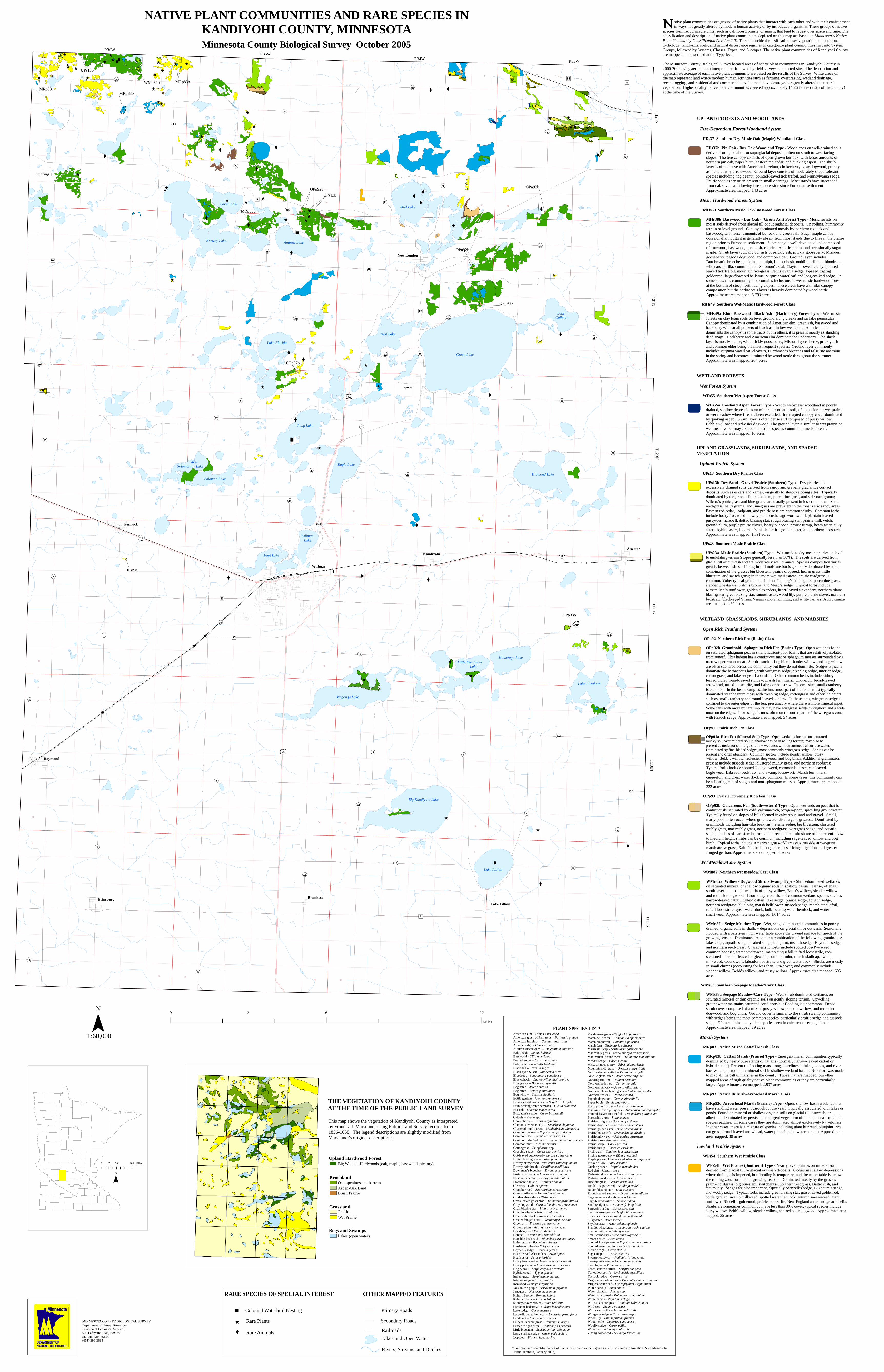
Brushland

Aspen-Oak LandBrush Prairie

Oak openings and barrens

Bogs and SwampsLakes (open water)

Grassland

Wet PrairiePrairie

Upland Hardwood ForestBig Woods - Hardwoods (oak, maple, basswood, hickory)

THE VEGETATION OF KANDIYOHI COUNTY AT THE TIME OF THE PUBLIC LAND SURVEY

This map shows the vegetation of Kandiyohi County as interpretedby Francis J. Marschner using Public Land Survey records from 1856-1858. The legend descriptions are slightly modified from Marschner's original descriptions.

*Common and scientific names of plants mentioned in the legend (scientific names follow the DNR's Minnesota Plant Database, January 2003).

PLANT SPECIES LIST*

Mountain rice-grass – Oryzopsis asperifolia Narrow-leaved cattail – Typha angustifolia New England aster – Aster novae-angliae Nodding trillium – Trillium cernuum Northern bedstraw – Galium boreale Northern pin oak – Quercus ellipsoidalis Northern plains blazing star – Liatris ligulistylis Northern red oak – Quercus rubra Pagoda dogwood – Cornus alternifolia Paper birch – Betula papyrifera Pennsylvania sedge – Carex pensylvanica Plantain-leaved pussytoes – Antennaria plantaginifolia Pointed-leaved tick trefoil – Desmodium glutinosum Porcupine grass – Stipa spartea Prairie cordgrass – Spartina pectinata Prairie dropseed – Sporobolus heterolepis Prairie golden aster – Heterotheca villosa Prairie loosestrife – Lysimachia quadriflora Prairie milk vetch – Astragalus adsurgens Prairie rose – Rosa arkansana Prairie sedge – Carex prairea Prairie turnip – Psoralea esculenta Prickly ash – Zanthoxylum americana Prickly gooseberry – Ribes cynosbati Purple prairie clover – Petalostemon purpureum Pussy willow – Salix discolor Quaking aspen – Populus tremuloides Red elm – Ulmus rubra Red-osier dogwood – Cornus stolonifera Red-stemmed aster – Aster puniceus Rice cut grass – Leersia oryzoides Riddell’s goldenrod – Solidago riddellii Rough blazing star – Liatris aspera Round-leaved sundew – Drosera rotundifolia Sage wormwood – Artemisia frigida Sage-leaved willow – Salix candida Sand reedgrass – Calamovilfa longifolia Sartwell’s sedge – Carex sartwellii Seaside arrowgrass – Triglochin maritima Side-oats grama – Bouteloua curtipendula Silky aster – Aster sericeus Skyblue aster – Aster oolentangiensis Slender wheatgrass – Agropyron trachycaulum Slender willow – Salix gracilis Small cranberry – Vaccinium oxycoccus Smooth aster – Aster laevis Spotted Joe Pye weed – Eupatorium maculatum Spotted water hemlock – Cicuta maculata Sterile sedge – Carex sterilis Sugar maple – Acer saccharum Swamp lousewort – Pedicularis lanceolata Swamp milkweed – Asclepias incarnata Switchgrass – Panicum virgatum Three-square bulrush – Scirpus pungens Tufted loosestrife – Lysimachia thyrsiflora Tussock sedge – Carex stricta Virginia mountain mint – Pycnanthemum virginiana Virginia waterleaf – Hydrophyllum virginianum Water parsnip – Sium suave Water plantain – Alisma spp. Water smartweed – Polygonum amphibium White camas – Zigadenus elegans Wilcox’s panic grass – Panicum wilcoxianum Wild rice – Zizania palustris Wild sarsaparilla – Aralia nudicaulis Wiregrass sedge – Carex lasiocarpa Wood lily – Lilium philadelphicum Wood nettle – Laportea canadensis Woolly sedge – Carex pellita Woundwort – Stachys palustris Zigzag goldenrod – Solidago flexicaulis

Marsh arrowgrass – Triglochin palustris Marsh bellflower – Campanula aparinoides Marsh cinquefoil – Potentilla palustris Marsh fern – Thelypteris palustris Marsh skullcap – Scutellaria galericulata Mat muhly grass – Muhlenbergia richardsonis Maximilian’s sunflower – Helianthus maximiliani Mead’s sedge – Carex meadii Missouri gooseberry – Ribes missouriensis

Lopseed – Phryma leptostachya

American elm – Ulmus americana American grass-of Parnassus – Parnassia glauca American hazelnut – Corylus americana Aquatic sedge – Carex aquatilis Autumn sneezeweed – Helenium autumnale Baltic rush – Juncus balticus Basswood – Tilia americana Beaked sedge – Carex utriculata Bebb’s willow – Salix bebbiana Black ash – Fraxinus nigra Black-eyed Susan – Rudbeckia hirta Bloodroot – Sanguinaria canadensis Blue cohosh – Caulophyllum thalictroides Blue grama – Bouteloua gracilis Bog aster – Aster borealis Bog birch – Betula glandulifera Bog willow – Salix pedicellaris Bottle gentian – Gentiana andrewsii Broad-leaved arrowhead – Sagittaria latifolia Bulb-bearing water hemlock – Cicuta bulbifera Bur oak – Quercus macrocarpa Buxbaum’s sedge – Carex buxbaumii Cattails – Typha spp. Chokecherry – Prunus virginiana Clayton’s sweet cicely – Osmorhiza claytonia Clustered muhly grass – Muhlenbergia glomerata Common boneset – Eupatorium perfoliatum Common elder – Sambucus canadensis Common false Solomon’s seal – Smilacina racemosa Common mint – Mentha arvensis Cottongrass – Eriophorum spp. Creeping sedge – Carex chordorrhiza Cut-leaved bugleweed – Lycopus americana Dotted blazing star – Liatris punctata Downy arrowwood – Viburnum rafinesquianum Downy paintbrush – Castilleja sessiliflora Dutchman’s breeches – Dicentra cucullaria Eastern red cedar – Juniperus virginiana False rue anemone – Isopyrum biternatum Flodman’s thistle – Cirsium flodmanii Cleavers – Galium aparine Giant bur reed – Sparganium eurycarpum Giant sunflower – Helianthus giganteus Golden alexanders – Zizia aurea Grass-leaved goldenrod – Euthamia graminifolia Gray dogwood – Cornus foemina ssp. racemosa Great blazing star – Liatris pycnostachya Great lobelia – Lobelia siphilitica Great water dock – Rumex orbiculatus Greater fringed aster – Gentianopsis crinita Green ash – Fraxinus pennsylvanica Ground plum – Astragalus crassicarpus Hackberry – Celtis occidentalis Harebell – Campanula rotundifolia Hair-like beak rush – Rhynchospora capillacea Hairy grama – Bouteloua hirsuta Hardstem bulrush – Scirpus acutus Hayden’s sedge – Carex haydenii Heart-leaved Alexanders – Zizia aptera Heath aster – Aster ericoides Hoary frostweed – Helianthemum bicknellii Hoary puccoon – Lithospermum canescens Hog peanut – Amphicarpaea bracteata Hybrid cattail – Typha glauca Indian grass – Sorghastrum nutans Interior sedge – Carex interior Ironwood – Ostrya virginiana Jack-in-the-pulpit – Arisaema triphyllum Junegrass – Koeleria macrantha Kalm’s Brome – Bromus kalmii Kalm’s lobelia – Lobelia kalmii Kidney-leaved violet – Viola renifolia Labrador bedstraw – Galium labradoricum Lake sedge – Carex lacustris Large-flowered bellwort – Uvularia grandiflora Leadplant – Amorpha canescens Leiberg’s panic grass – Panicum leibergii Lesser fringed aster – Gentianopsis procera Little bluestem – Schizachyrium scoparium Long-stalked sedge – Carex pedunculata