Embed Size (px)
Citation preview

NASA Global Hawk Overview
Armstrong Flight Research Center
June 2017
www.nasa.gov
National Aeronautics and Space Administration
https://ntrs.nasa.gov/search.jsp?R=20170006086 2020-01-12T12:08:23+00:00Z

Summary and Capability
Endurance24-26 hours for typical missions; 28.6 hours
demonstrated
Range 10,000 nautical miles (nmi)
Service Ceiling65,000 feet, < 50% available aircraft payload power
62,500 feet, > 50% available aircraft payload power
Airspeed (55,000+ feet) 335 knots true airspeed (KTAS)
Payload 1,200 pounds demonstrated
Length 44 feet
Wingspan 116 feet
NASA/Northrop Grumman Corporation (NGC) team maintains, modifies, and
operates two aircraft through a partnership established in 2008 (renewed, 2013)
NASA has been flying Global Hawk aircraft for airborne Earth Science research
since 2010
To date, ~168 missions have been flown, with a total of 2,100+ flight hours
Autonomous aircraft are remotely operated from either NASA Armstrong, NASA
Wallops Flight Facility (WFF), or remote locations via portable flight control station
2Armstrong Flight Research Center

Asset Overview
3Armstrong Flight Research Center
NASA Armstrong
Global Hawk tail
number (TN) 871
is now retired
Armstrong’s
Block 10 Global
Hawk TN 874 is
being refurbished
Global Hawk Operations Center – East
(Wallops Flight Facility)
Portable Ground Systems
Spares Aircraft
Global Hawk Operations Center (GHOC)
(NASA Armstrong)
Operational Aircraft

Operations Overview
Edwards Air Force Base (EAFB)/NASA Armstrong
4Armstrong Flight Research Center
EAFB Runways Mission Staging Locations
Maintenance Hangar and
Instrument Laboratory
Flight Operations CenterEdwards Air Force Base
NASA
Armstrong

Equipment
Racks
Air
Handler
Fa
cil
ity
En
tra
nc
e
Support
Equipment
Room (SER)
GHOC
Operator
Mission
DirectorPilot Co-Pilot
Range
Safety
Officer
Flight Operations Room (FOR)
14 Customer Workstations
Payload Operations Room
GHOC Layout

GHOC Fully Staffed During a Hurricane Overflight

GHOC East at Wallops Flight Facility (WFF), Virginia

Portable Ground Control Station (GCS)
Suite used for deployed operations
8Armstrong Flight Research Center
Ku Satellite Ground Station
Payload Operations Facility Global Hawk Mobile Operations Facility

Aircraft Flight Control and Air Traffic Control
Communications architecture
9Armstrong Flight Research Center
Iridium
provides
global
coverage
Encrypted links
are used for
aircraft
command and
control

Payload Communications Architecture
10Armstrong Flight Research Center
Iridium provides
global coverage
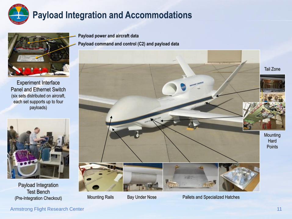
Payload Integration and Accommodations
11Armstrong Flight Research Center
Payload Integration
Test Bench(Pre-Integration Checkout)
Experiment Interface
Panel and Ethernet Switch(six sets distributed on aircraft,
each set supports up to four
payloads)
Tail Zone
Bay Under Nose
Mounting
Hard
Points
Mounting Rails Pallets and Specialized Hatches
Payload command and control (C2) and payload data
Payload power and aircraft data

Payload Integration Process
Site visit at customer’s location: initial
discussion of payload and operational
concept
Receipt of payload solid models and
design/integration data from customer
Integration engineering (performed by
NASA Armstrong and/or NGC)
Avionics harness fabrication at
NASA Armstrong
Fabrication and fit-check of payload
mounting structure
Initial mechanical integration on aircraft
12Armstrong Flight Research Center

Payload Integration Process
Environmental tests on payloads, as
required
Electrical integration on payload test bench
Final integration on aircraft
Payload communications and payload data
telemetry verification in the GHOC
Combined system test (CST) with all
aircraft and payload systems operating
Range check-out flight
Ready for operational flights
13Armstrong Flight Research Center

Global Hawk Science Flights
GloPac
2010
GRIP
2010
WISPAR
2011
HS3
2011, 2012, 2013
ATTREX
2011, 2013, 2014
IceHawk
2013
14Armstrong Flight Research Center

Global Hawk Science Flights
GloPac
2010
GRIP
2010
WISPAR
2011
HS3
2011, 2012, 2013
ATTREX
2011, 2013, 2014
IceHawk
2013
SHOUT (NOAA)
2015, 2016
15Armstrong Flight Research Center

Global Hawk Pacific (GloPac) Flights
16Armstrong Flight Research Center
April 13
24.3 hours, 8,000 nmi,
62,300 feet
April 23
28.6 hours, 9,700 nmi,
65,200 feet
April 7
14.1 hours, 4,600 nmi,
61,200 feet

Genesis and Rapid Intensification Processes (GRIP) 2010 Flights
17Armstrong Flight Research Center
Tropical Depression Frank
(Aug. 28, 15.3 hours)
First GRIP mission
First storm over-flight
Hurricane Earl
(Sept. 1-2, 24.2 hours)
First hurricane mission
First Atlantic flight
Tropical Disturbance AL 92
(Sept. 12-13, 24.3 hours)
First Caribbean flight
First Genesis flight
Hurricane Karl
(Sept. 16-17, 25.2 hours)
Intensification (Cat 1-3)
20 eye overpasses
15.5 hours over the storm
Tropical Storm Matthew
(Sept. 23-24, 25.1 hours)
International cooperation
NASA Armstrong
Edwards AFB

Winter Storm Pacific and Atmospheric Rivers (WISPAR) Overview
February-March 2011
First National Oceanic and Atmospheric
Administration (NOAA)-sponsored Global
Hawk Earth Science campaign
Two instruments were installed
on the aircraft: High-Altitude
Monolithic Microwave
Integrated Circuit Sounding
Radiometer (HAMSR)
and Advanced Vertical
Atmospheric Profiling System (AVAPS)
Three science missions
were flown, with a total of
70 flight hours
First operational dropsonde deployment
from any unmanned air vehicle (UAV) (70
were deployed during a single flight)
18Armstrong Flight Research Center
Dropsonde
deployment
Dropsonde
on chute
Flight tracks

HS3 Explored Nadine’s Interaction with Saharan Air Layer (SAL)
September 11-12, 2012
Warm, dry, dusty air
wrapped around the
eastern and northern side
of Nadine, but didn’t get
into the storm circulation
19Armstrong Flight Research Center
Tropical
storm
NadineSAL dust
Dust
Sample data from the
Cloud Physics LIDAR (CPL)

IceHawk
December 2013
UAV Synthetic Aperture Radar
(UAVSAR) was integrated onto the
aircraft
A single flight was conducted over
the Pacific Ocean and Canada
Flight marked the first UAVSAR
flight outside of the EAFB range
and the first NASA Global Hawk
flight over a foreign country
Coordination with the Canadian
Government was straightforward
IceHawk flight was funded by NGC
20Armstrong Flight Research Center

Global Hawk ‘Firsts’ Accomplished by the NASA/NGC Team
1. Flights above 70 degrees latitude; the aircraft has reached 85 degrees N three times
2. Flights over hurricanes and severe storms, including a single flight that included 15.5 hours over a
hurricane and 20 over-flights of the eye
3. Vertical profile maneuvers during science flights for the collection of atmospheric data
4. Release of dropwindsonde weather instruments in the national airspace system (first Federal Aviation
Administration [FAA] approval for release of stores from a Global Hawk)
5. First Global Hawk operations at WFF and first science flights from Andersen Air Force Base, Guam
6. Autonomous formation flight of two Global Hawk aircraft, which were as close as 30 feet apart while
flying in formation for 2.5 hours
21Armstrong Flight Research Center

Global Hawk ‘Firsts’ Accomplished by the NASA/NGC Team
7. Implementation of an independent payload power and date telemetry system on Global Hawk
8. Flight of the Active Electronically. Scanned Array (AESA)-360 radome on a Global Hawk aircraft
(Radome provides greater volume for instruments under the aircraft and has been used to house the
High-Altitude Imaging Wind and Rain Airborne Profiler [HiWRAP] and Twilite instruments)
9. Implementation of wing-mounted instruments on an Advanced Concept Technology Demonstration
(ACTD) aircraft (Hawkeye for ATTREX 2014)
10. Ku system implementation for payload data telemetry, payload C2, and Ku air traffic control (ATC)
11. Implementation of Airborne Research Test System (ARTS) on a Global Hawk aircraft
12. Implementation of a rear payload mounting capability in the tail cone and on the bottom of the aircraft
under the rear pressurized compartment
Armstrong Flight Research Center 22

Global Hawk ‘Firsts’ Accomplished by the NASA/NGC Team
13. Aircraft C2 with Iridium communications links
14. ATC communications with Iridium communications links
15. Dissemination of high-definition pictures from the aircraft to the public in real time (pictures and the flight
track are shown on a publicly available website for public awareness of the science missions)
16. Largest geographical Certificate of Authorization (COA) ever granted by the FAA (GloPac COA covers
most of the Pacific Ocean north of the Equator, and extends to the North Pole)
17. Most complex mission plan ever created (GRIP mission plans contains many routes to ensure options
for avoiding restricted areas and avoiding atmospheric conditions outside of aircraft limits
18. Development of a new ground control station, based on NGC’s Common System Architecture
23Armstrong Flight Research Center

Mission Planning and Pilot Discussion
Kyle Salling (NOAA) creating COAs, airfield landing agreements, and country
border notifications
Erick Munoz (NGC) mission planning
24Armstrong Flight Research Center

Frank Cutler
NASA Armstrong
Global Hawk Project Manager
661-276-3998
Tropical Depression Frank, August 28, 2010