Embed Size (px)
Citation preview

The bridge of Color Fantasy represents thelatest in navigation and safety equipmentwith its Sperry Vision FT Integrated Bridgesystem. The centrepiece of the equipmentis the Sperry Voyage Management System,which is designed to provide easy andprecise route planning and give a real timeoverview of the ship’s position and move-ments. Radar targets and data from theautomatic identification system are alsopresented on the Electronic Chart Displayand Information system. The system en-hances safety of navigation by improvingsituation awareness for the bridge officers.
C - M A P U P D A T E - S U M M E R - 2 0 0 5
UPDATEA NEWSLETTER FROM THE PROVIDER OF NAUTICAL INFORMATION FOR SAFE NAVIGATION - SUMMER 2005
I N S I D ENavigation Chart for Malaysia and the Malacca Straits
State of the art Nautical InformationService presented to the Hellenic Maritime Industry
ENC distribution agreement with theItalian Hydrographic Office
Hanseatic Marine Training School onCyprus selected CM93/3
Integrating nautical charts and weatherinformation contributes to safer traffic
C-MAP embarks on a comprehensive R&Dproject comprising a new Nautical InformationService for the world of shipping.
M/S Color Fantasy sails with official ENC from C-MAP
C-MAP, the industry’s leading provider ofelectronic charting, is proud to announcethat the company was recently awarded aresearch and development grant fromInnovation Norway, an institutionresponsible for the promotion of nationalindustrial development.
The R&D grant will cover a substantialpart of C-MAP’s development cost to provide ship owners and management
companies with NIS (Nautical InformationServices), comprising all necessary navigational information a vessel requiresfor any given voyage. This includes papercharts and publications, as well as thevery latest in “state of the art” electronicnavigation functionality, such as anti-grounding, AIS based anti-collision,weather routing, and 3-dimmentionalcartography to mention a few. The aim is
Color Line’s new flagship M/S Color Fantasy the worldslargest cruise ferry with a car deck, sailed on her maidenvoyage from Oslo to Kiel in December 2004. The facilitieson board Color Fantasy ensure that all the 2750 passengers are guaranteed luxurious facilities and themost sophisticated cruise ship experience available today.
Capt. Olav Berger (left) and chief officer RobertBærulfsen on Color Fantasy.
Continued on page 2.
Continued on page 8.
distribute official ENCs of Indian watersC-MAP Norway first company to

Captn’sCorner
C-MAP launches Electronic NavigationChart for Malaysia and the Malacca Straits
C-MAP is pleased to announcethat the first ElectronicNavigational Charts (ENC)covering Malaysian watershave been released. Working in close cooperation with theHydrographic Department of the RoyalMalaysian Navy (HDRMN), C-MAPMalaysia has secured an agreement toprovide official charts covering Malaysianwaters, extending C-MAP’s coverage ofthe major shipping routes of the world.
C-MAP will make available Malaysian ENCdata to end users in the encrypted systemENC format, which is supported by C-MAP’s Real Time Updating Service. Thisservice enables end users to log on the C-MAP server and download Notices toMariners using Internet or e-mail. Vesselsequipped with type-approved ECDIS
systems operating in Malaysian waters cannow utilise the full potential of their systems in this region.
In addition, C-MAP will also distributeofficial ENC data produced in cooperationwith authorities in Singapore, Indonesiaand Malaysia. The project was funded byJapan in the interests of improving thesafety of navigation of vessels in theMalacca Straits, a route which has someof the highest traffic density in the world.Notices to mariners will also be availableon the C-MAP Real Time Updating Service.
The distribution of the HDRMN ENC withReal-Time Updates Service confirms C-MAP’s long-term commitment to pro-viding customers with the most compre-hensive portfolio of official ENC chartdata available to the market today, andthe company’s efforts to improve safety ofnavigation at sea in these critical waters.
C-MAP has been a pioneer in the production of digital nautical charts andhas supported the work of hydrographicorganisations in the production of ENCdata. C-MAP has in fact produced digitaldata as a sub-contractor to varioushydrographic offices, data which theyhave quality controlled and then issued asENC data which C-MAP now distributes toend users supported by a Real TimeUpdating service.
The future for C-MAP is based on theexperience gained through the distri-bution of electronic navigational charts,which formed the foundation for thedevelopment of a Nautical InformationService described in this issue of Update.End users require a cost effective, qualityproduct from a service provider. The abilityto rationalise, co-ordinate and maintainall the nautical information for a specificvessel to ensure safe navigation is important task. This is the concept behindour Nautical Manager.
Continual advances are being made in thefield of data collection, presentation anddistribution. Global coverage of high-resolution weather data is now a reality,presentation and distribution to shippingcompanies and bridge personnel is wherethe challenge lies. The ability to enhancea navigational chart with terrestrial dataand display this data to a navigator inorder to improve vessel safety and efficiency is a further challenge in whichC-MAP is involved.
Our vision is to be a single source supplierof a unique range of cost effectivenautical information that will serve to enhance safety of navigation at sea. Thefact that Innovation Norway understandsand shares our vision means that newproducts and services will be availablefrom C-MAP within a year.
Tor A. Svanes. CEO and President
C - M A P U P D A T E - S U M M E R - 2 0 0 5
The Sperry ECDIS is a key element in thebridge system. Sailing in the waters between Oslo and Kiel where there is oftenheavy traffic in confined waters it iscrucial that the charts displayed on theECDIS system are the most accurate thatare available. En-route Color Fantasy sailsthrough Norwegian, Swedish, Danish andGerman waters, all of which are covered
by official Electronic Nautical Chartsissued by the respective national Hydro-graphic Offices.
Color Line has invested in the best equip-ment and services available and since theSperry IBS and ECDIS systems are type approved the vessel can sail without having to carry paper charts. C-MAP hasworked closely with Sperry in the imple-mentation of electronic charts in theirECDIS system and has been selected byColor Line to supply the official ElectronicNavigational Charts to Color Fantasy. TheC-MAP ENC chart service is backed up by a Real Time Updating service. The C-MAPENC database is updated weekly based onofficial Notices to Mariners from theHydrographic Offices, the ships bridgewatch officers than have the latest updatedcharts available.
Experience from Color Fantasy demon-strates the advantages of using the bestpossible systems and navigation infor-mation. The workload related to updatingpaper charts is reduced considerably andthe bridge officers are able to focus on thenavigation of the vessel, an importantfactor in increasing vessel safety.
Chief officer Robert Bærulfsen on the bridge ofColor Fantasy taking advantage of the Sperry IBSand ECDIS systsem. Sailing with official ENCs sup-plied by C-MAP Norway allowing him to navigatepaperless which he consider a big advantage.
Captn’sCorner
2
From frontpage

C-MAP presents the state of the art‘Nautical Information Service’ to theHellenic Maritime Industry in Greece.
Combining C-MAP CM93/3Professional and official ENCgives the ultimate vectorchart solution, the naturalchoice in an ECDIS
C-MAP Hellas, a branch office of C-MAPNorway, which is the leading company inHigh Seas Electronic Nautical Chartsbusiness, organised a presentation in theYacht Club of Greece. More than 150 distinguished members from the Hellenic
Navy Hydrographic Office, Ministry of theMerchant Marine, Hellenic Coast Guard,Merchant Marine Academy, AthensUniversity and Shipping Companies att-ended this presentation.
C-MAP has the largest database ofelectronic vector charts, the CM93/3Professional, and is the first company tohave an electronic chart database testedand approved in accordance with the ISO19379 standard. This is an important steptowards offering cerified and high qualityvector chart data for ECS and ECDIS use
and C-MAP is therefore a major contri-butor to the safety of navigation.
As ENC coverage of more and more watersbecomes available from HydrographicOffices for the maritime industry, C-MAPhas become a major player in the distri-bution of official ENC. Due to the superiorC-MAP SENC distribution system, the pro-cess of loading and updating the ENC datais easy and secure whether it will be for anECDIS or an ECS. By offering the Real TimeUpdating service (RTU) “free of charge” tosubscribers of the C-MAP navigation service, C-MAP ensures that its customerscan always have the latest updated chartdata and information that is available.
What also caught interest was C-Map’sunique Electronic Chart format that makesit possible to combine the Official ENCsissued by the National HydrographicOffices and CM 93/3 Professional datawhere ENCs are not available. The result isa seamless, worldwide coverage of highquality vector charts. It was emphasizedthat by using the Official ENCs in a typeapproved ECDIS system, it is then possibleto replace the paper charts is required tobe carried by SOLAS class vessel.
C - M A P U P D A T E - S U M M E R - 2 0 0 5
C-MAP SIGNS ENC DISTRIBUTION AGREEMENT WITHTHE ITALIAN HYDROGRAPHIC OFFICE
C-MAP to announce earlierthis year that an agreementwith the Italian Hydro-graphic Office, (the IstitutoIdrografico Della Marina)has been signed, appointingC-MAP as the first officialdistributor of Italian ENC.
The efforts made in the context of theMediterranean and Black Sea Virtual RENC(MBSV-RENC) are now giving the first results, and C-MAP is working hard toextend such contracts to many othercountries participating in the MBSV-RENC.
One of C-MAP Norway’s prime goals is tooffer our customers the most comprehen-sive ENC chart portfolio available. It iswidely recognised that chart coverage isof critical importance to end users and theextensive Italian portfolio is a major
enhancement to the ENC portfolio distri-buted by C-MAP. At present C-MAP hasestablished contractual agreements thatinclude distribution of ENCs from 21National Hydrographic offices, which represents all the major waters currentlycovered by ENC.
As more and more waters are covered withENC and made available for the maritimeindustry, C-MAP has become a major play-er in the provision of official ENC navigational data.
Continued on page 4
3

By using the superior C-MAP SENC distribution system, the process of loadingand updating the ENC data is easy andsecure whether it will be for an ECDIS oran ECS. By offering the “free of charge”Real Time Updating service (RTU) for subscribers of the C-MAP navigation service, C-MAP ensures that it’s customers
always have the latest updated chart andinformation data available. Official ENCsfulfil the IHO S-57/3.1 product specifi-cation and have the most recent updateddata from originating NationalHydrographic Offices. When used in anECDIS, ENC data facilitates uniquefunctionality that improves the safety ofnavigation at sea. Where ENC coverage isnot available C-MAP recommends using
the CM-Professional vector chart data-base, which is certified to ISO 19379 byDNV and offers the navigator a “Dual Fuel”solution combining ENC and C-MAP. Moreand more navigators discover the benefitof C-MAP vector charts in combinationwith ENC to get the full benefit out of theECDIS or ECS, an advantage impossible toachieve with raster charts.
C - M A P U P D A T E - S U M M E R - 2 0 0 5
Limassol, Cyprus, based Hanseatic MarineTraining School (HMTS) will be usingCM93/3 vector chart data in their SeaInformationSystems (SIS) simulator, whichcomprises an instructor work station and 5student work stations.
HMTS provides a comprehensive trainingfacility for a wide range of maritimedisciplines and has among its clients animpressive list of major shipping organ-isations.
The simulator has recently been upgradedto the latest specification which, togetherwith the CM93/3 charts, provides a veryrealistic training environment. CM93/3was chosen for its quality and ease of usewith full vector capability.
The CM93/3 charts initially cover theEnglish channel / Dover straits area pro-viding a very demanding training environ-ment in some of the worlds most conge-sted waters.
From page 3
HMTS was established in 1983 to provide a pool of seafarers, trained to meetthe industry’s high quality standards. It has been so successful that it now hasthe approval of many flag states. Amongst its many successes, in 1998 theschool was given the Lloyds “Youth & Training Award” for its outstanding andconsistent contribution to training within the maritime industry.
Hanseatic Marine Training Schoolon Cyprus selected CM93/3 fortheir Sea Information Systems
A Dream came
After 1,5 years of preparation for their return voyage Oslo/Svalbard Eva Spilleth,Barbara Winter, Elise Halvorsen and RagneElise Berre set sail in their recent acquiredComfortina 32.
Even though the goal was to sail from Osloto Svalbard and back, we all agreed thatthe nature and personal experiences werethe most important issue.
The whole trip is filled with impressions,and we are overwhelmed over the hospit-ality people gave us along the coast. Onthis trip we where lucky enough to getComfortina equipped with some of today’smost advanced light marine electronicequipment.
Especially essential was the chart plotterwith C-Map’s chart around Svalbard.
Overall the experiences we had as a groupand personally is hard to rewrite, but ourrecommendation to all of you that have adream, believe it “dreams can come true.”
The four young adventurers accompanied by C-MAP’s
Marketing Manager Willy Zeiler.
4
true…

AMERICAN SHIP MANAGEMENTRELIES ON C-MAP’S CM-93/3 AMS takes advantage of C-MAP’s Professional Electronic Database for superiorintegrated electronic charting aboard C-11 class container ship APL China
Guiding a giant container shipover an arduous, 35-day Trans-Pacific trade route is seriousbusiness. First, you have toconsider the size and carrying capacity of the ship itself – atmore than three football fields inlength, today’s largest containerships can carry more than 2,40040-foot containers laden withanything from electronics andclothing to automotive parts orfood.For each vessel, that adds up to uncountedtons of ship and millions of dollars ofcargo in almost constant motion aroundthe globe, through everything from roughweather to hazardous sailing conditions tocrowded waterways.
You must also consider the financial importance of this activity. Shipping is acritical link in global supply chains – thecomplex movement of and demand forraw materials, parts, sub-assemblies andfinished products. If this link breaksdown, important parts of the global economy can grind to a halt. Seriousbusiness, indeed.
American Ship Management, LLC (ASM)operates 11 large high-speed container
ships on behalf of APL, Ltd. ASM hasmanaged these vessels since the fall of1997. ASM provides all necessarytechnical management and crewing to operate these vessels in compliance withthe high standards that APL, Ltd. demands.
Given this tradition of leading the techno-logy curve, it’s understandable why ASMselected C-MAP’s CM-93/3 globalelectronic chart database for the helm ofthe C-11 Class, 4,800 TEU container shipAPL China. Built in 1995, APL China is oneof the largest container ships in the ASMworldwide fleet. With world wide coverageof electronic charts on one CD and on-demand corrections via the Internet oremail, CM-93/3 provides the crew of theAPL China the most up-to-date electroniccharts for every port and every harbor inthe world.
APL China follows a 35-day voyage stopp-ing in the major trade ports of San Pedro,CA; Oakland, CA; Dutch Harbor, AK;Yokohama, Japan; Pusan Harbor, SouthKorea; Xiamen, China; Hong Kong, China;Yantian, China and Kaoshiung, Taiwan.The captain and bridge crew of the APLChina depend on C-MAP’s CM-93/3electronic chart database – integratedwith the ship’s AIS, two ARPA radars andSperry Voyage Management System™(VMS) – every step of the way. “Our crewuses the C-MAP system all the time, because it interfaces smoothly with theVMS,” commented APL China CaptainMark Remijan.
The VMS is a highly advanced ProfessionalElectronic Chart System (ECS) from SperryMarine, a unit of Northrop GrummanSystems Corporation. In addition to read-ing CM-93/3 electronic charts, it offers avariety of additional modules including;Conning Display, Planning Station,Automatic Navigation and Track KeepingSystem, Vessel Advance Prediction, Voyage DataRecorder and Vessel Optimization and Safety.
C - M A P U P D A T E - S U M M E R - 2 0 0 5
C-MAP charts in use on one of the Reefership Marine Services vessels
Captain Mark Remijan aboard the APL China
5

Back in March 2003, APL China completedher changeover to a U.S. flagged vesseland a few months later had her SperryVMS upgraded from raster charts to C-MAP CM-93/3. Watch officers immedi-ately noted an increase in available information, improvement in chart coverage on their trade route and betterdisplay quality. “I have no doubt thatwith our new C-MAP charts, navigationalsafety has been improved, as well as theeffectiveness of the bridge team in conge-sted waters,” said Captain Remijan.
ASM has been a C-MAP customer sincethe start (circa 1998) and has been addingvessels ever since. “Their continuedexpansion into the foreign Asian ports hasbeen especially rewarding for us as ourglobal coverage for this part of the worldis as up-to-date as any other developedport area,” states C-MAP US CommercialOperations Manager, Eric James. “Wecount on C-MAP and our Sperry VMS asan important supplement to our papercharts,” added Captain Remijan.“C-MAP’s electronic chart database alsoplays an important role in providing theconning officer a convenient method todouble-check the vessel’s navigational plotand access detailed chart information.”All C-MAP CM-93/3 subscription custom-
ers are entitled to unlimited access to theC-MAP Real Time Updating (RTU) serviceto download important changes likeNotice to Mariners updates from anywherearound the globe. The flexibility of this
system allows the crew to utilize C-MAP’sconstantly updated worldwide chart data-base in the way that best fits the needs oftheir vessel.
APL China receives updates quarterly onCD, and the crew loads them into the system while the ship is at berth. C-MAP, acompany who prides itself on responsiv-eness and customer service, came throughwhen the crew raised the need for specificimportant updates over their route.Examples of these include concerns abouta new channel and coverage at the port of
Xiamen, China and the updating of chartson the VTS approaching the portKaoshiung, Taiwan. “Both these concernswere addressed promptly and profession-ally,” said Captain Remijan. “We’ve beenvery satisfied with C-MAP’s CM-93/3electronic chart database and the level ofservice we receive.”
“The RTU service that C-MAP provides isthe engine for keeping a vessel’s electronicchart database up-to-date,” states James.“The ability for vessels on such long distant water voyages such as APL Chinato access our RTU service at any time, pro-vides the ultimate in navigational safety,allowing the ship’s crew to instantly getupdates to their next scheduled port ofcall or one that was not planned as part oftheir voyage.
C - M A P U P D A T E - S U M M E R - 2 0 0 5
Recently, the Indian National HydrographicOffice developed a complete portfolio ofENCs covering Indian national waters andreached an agreement with C-MAPNorway to provide an ENC updating service.
According to the terms of the agreement,Indian ENC data will be made available toend users in the encrypted C-MAP ENCformat, which is accompanied by a RealTime Updating Service. This service enablesend users to log on the C-MAP server anddownload Notices to Mariners usingInternet or e-mail. Vessels equipped with
type-approved ECDIS systems operating inIndian waters are now able to realise thefull potential of their systems.
The distribution agreement with the IndianNational Hydrographic Office is a signifi-cant step in C-MAP’s efforts to provide customers with the most compre-hensive portfolio of official ENC chart dataavailable from a single supplier. Chart cov-erage is of critical importance to end usersand making the Indian portfolio availableto vessels is a further enhancement of theofficial ENC portfolio presently distributedby C-MAP.
C-MAP Norway is pleased to announce that it has been namedthe first commercial company to successfully conclude a distri-bution agreement with the Indian Hydrographic Office tomake official Electronic Navigational Charts (ENC)s of Indianwaters available to vessels operating in the area.
6
The first Electronic Navigation Chart covering shipping routes in Indian waters
Admiral Rao, Indian Hydrographer hands over ENCs to
Capt Raj Chakravorty of C-MAP India for Distribution
The aim of the company is to combine C-MAP’s technology in the field of digitalcartography with metrological expertiseand supply international shipping and off-shore customers with innovative softwaretools for a geo-referenced presentation ofmetrological information.
Using the best weather forecast in-formation available, the aim is to find newmethods to integrate and exploit allweather related information. An initialstep is to integrate information which ispresently available e.g., high resolutionnumerical weather data covering trafficareas in coastal waters, traditional observations, data from satellites etc., thenextract such information and tailor it forindividual ships based on where they areat a particular time and their intendedvoyage. Improved quality, availability anduse of weather data will contribute to safer more effective vessel traffic in alltypes of waters.
C-MAP Weather View is the first productthat has been launched. This incorporatesa weather module that presents high qual-ity weather forecasts with innovativefunctionality and customised presentationof weather using nautical charts as abackground. Parameters such as pressure,temperature, wind velocity and direction,precipitation, dew point, cloud cover,waves and swell waves can be presentedalong a planned route with the possibilityof displaying areas of bad weather basedon user defined limits.
C - M A P U P D A T E - S U M M E R - 2 0 0 5
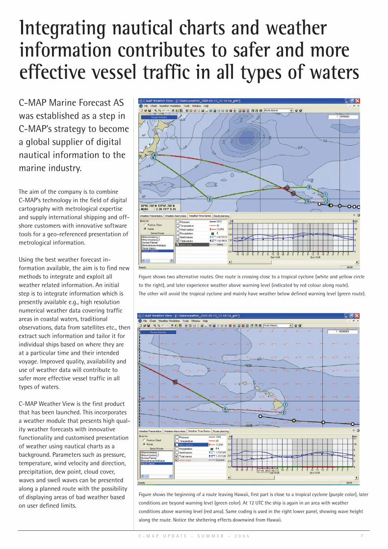
Integrating nautical charts and weather information contributes to safer and moreeffective vessel traffic in all types of watersC-MAP Marine Forecast ASwas established as a step inC-MAP’s strategy to becomea global supplier of digitalnautical information to themarine industry.
Figure shows two alternative routes. One route is crossing close to a tropical cyclone (white and yellow circle
to the right), and later experience weather above warning level (indicated by red colour along route).
The other will avoid the tropical cyclone and mainly have weather below defined warning level (green route).
Figure shows the beginning of a route leaving Hawaii, first part is close to a tropical cyclone (purple color), later
conditions are beyond warning level (green color). At 12 UTC the ship is again in an area with weather
conditions above warning level (red area). Same coding is used in the right lower panel, showing wave height
along the route. Notice the sheltering effects downwind from Hawaii.
7

to provide a complete range ofnautical services to all SOLASclassed vessels.
“The funds provided by InnovationNorway will enable us to create aone-stop-shop concept for ourproducts and services,” says TorAndreas Svanes, President & CEO ofC-MAP Norway AS. “The fact thatour application was approved byInnovation Norway is a con-firmation of C-Map’s international stand-ing in the marine industry. Importantcriteria for this R&D project were that C-MAP was capable of not only techno-logical development but also able tolaunch and market the results inter-nationally. C-Map’s marketing and distri-bution network, our large customer base,proven distribution infrastructure and ourtradition of developing innovativetechnologies for the shipping industry,were all key elements in the approval ofour application,” he continues.
According to Mr. Svanes, the final stageof the Nautical Information Service pro-ject will include extensive sea trials.COSCO Group in China, Neptune ShipManagement Services in Singapore, andNorwegian Østensjø Rederi AS willparticipate in the project and test thevarious elements of the NauticalInformation Service on board their
vessels. C-MAP will draw on the expertiseof a network of Norwegian-based navigation equipment manufacturersincluding CAE Navigation, Telko, andVirtek as well as the national research institute Marintek.
Field tests will be carried out during thesecond half of 2006 and the new NauticalInformation Service will be commerciallyavailable in 2007. Mr. Svanes is confidentabout C-MAP’s future as a service provid-er. “There are more than fifty thousand(SOLAS classed) vessels operating throug-hout the world,” he says. “Of these, weestimate that roughly 10% presently useelectronic charts, representing significantgrowth potential for our products andservices. In addition, we believe that bydeveloping new services such as NIS, wewill have even more to offer, whereby wecan continue to grow our market share.”
C-MAP has a global electronic
chart service specifically
designed to meet the needs of
merchant marine vessels
operating worldwide. C-MAP
distributes the most complete
portfolio of official Electronic
Nautical Chart ENC data and the
world's largest commercially
available database with 15250
chart files the equivalent
coverage of approximately 8000
paper charts. Both databases are
backed up by a Real Time
Updating service. Over 90 manu-
facturers of navigation, vessel
traffic control and fleet manage-
ment systems read and display
C-MAP digital chart data.
C-MAP Norway ASP.b 212, N-4379 EGERSUND, Norway
Tlf +47 51 46 47 00. Fax +47 51 46 47 01 E-mail: [email protected]
www.c-map.no
Mr. Sun Kenuo, President of COSCO Enterprises Co and Mr. Tor Svanes, President and CEO of C-MAP Norway.
C - M A P F A C T S
A b o u t C - M A P
• Worldwide electronic vector charts coverage
• Official distributor of ENC from19 Hydrographic Offices
• C-MAP subsidiaries are located in all major maritime markets
• Navigation Systems compatible with C-MAP charts:- ECDIS 18 (type approved)- ECS/Others 72
Edda Fram from Østensjø Rederi AS, Haugesund, Norway.
From frontpage.
8 C - M A P U P D A T E - S U M M E R - 2 0 0 5


![Fwd: [juizesfree] ENC: Enc: Papagaios do Brasil](https://img.dokumen.tips/doc/110x75/5587e05ed8b42a15638b4725/fwd-juizesfree-enc-enc-papagaios-do-brasil.jpg)