Embed Size (px)
Citation preview

User Guide
Monuments and Markers Database
Wyoming Department of State Parks and Cultural Resources
User Guide and Database Prepared By: Dennis Grasso Rainbow Computer Consulting Cheyenne, Wyoming Rev. 2.0 (March 21, 2005)

2
Table of Contents: Introduction............................................................................................................................................... 3
Program History........................................................................................................................................ 3
Contents and Organization ....................................................................................................................... 4
Layouts ................................................................................................................................................. 4
How To Use The Database ................................................................................................................... 5
Import and Export Data ........................................................................................................................ 7
Appendix A: Field Descriptions ......................................................................................................... 10
Appendix B: Value Lists .................................................................................................................... 13
List of Figures: The figures, located at the end of this document, are organized as listed below. Each figure is a full-page printout of a single site record in the database, except for the List and Maintenance List layouts, which show multiple sites. Different sites were used in the preparation of these example pages.
Fig 1. List Layout 1a. Data Sheet Layout
Fig 2. General Layout Fig 3. Photographs Layout
3a. Zoom Photo 1 Layout 3b. Zoom Photo 2 Layout 3c. Zoom Legend Photo Layout 3d. Zoom Additional Photos (A) Layout
Fig 4. Location Layout 4a. Zoom Map Layout
Fig 5. Inspection Layout Fig 6. Management Layout Fig 7. Maintenance Layout
7a. Maintenance List Layout Fig 8. Help Page (1 of 5)
8a. Help Page (2 of 5) 8b. Help Page (3 of 5) 8c. Help Page (4 of 5) 8d. Help Page (5 of 5)
Software Environment: FileMaker Pro v. 7; FileMaker, Inc.; http://www.filemaker.com
More Information: Adobe acrobat (PDF) versions of this User Guide, example site layouts with how-to information, and other documentation are in the Documents subfolder. The FileMaker Pro website has software updates, user forums, and articles on various subjects related to FileMaker Pro database applications.

3
Introduction The Monuments and Markers Database is a comprehensive storage, retrieval, and management system for information about Wyoming’s historical monuments and markers. The database includes relational data tables, tabbed layouts, scripts, and linked photographs and maps that run within the FileMaker Pro 7 software environment. Folder-like tabs give easy access to layouts for entering, editing, viewing, and retrieving information. Control icons and buttons allow users to find, view, print, and export data for all or a selected set of monument and marker sites in the database.
Program History The database was originally developed in 2002 by Harrison Goodall, Conservation Services, as a series of templates running in FileMaker Pro 6. The goal was to “provide a simple and easy way to record, organize, and access information about Wyoming’s Monuments and Markers” (Monuments & Markers Program Reference Guide, 2003, p. 1). From 2001 to 2004, Sheila Bricher-Wade and Richard Collier, Wyoming State Historic Preservation Office, conducted site visits to nearly all monument and marker sites in Wyoming. They recorded Global Positioning System (GPS) coordinates and site condition information and amassed more than 2,500 digital photographs. Concurrently, Rose Wagner compiled legend text, driving directions, and other site information with the intent that all of these data would ultimately be consolidated into a single, comprehensive database.
In 2004, Dennis Grasso, Rainbow Computer Consulting, was contracted to update the database, upload all available site information, and develop a user interface that would allow for multi-level access by its primary users, namely: (1) State Historic Preservation Office (SHPO), (2) State Parks and Historic Sites (SPHS), (3) Wyoming Department of Transportation (WYDOT), and (4) the public. The goal was to provide an efficient means to enter new data, view and modify existing data, check the status of sites, track maintenance information, generate reports, and export data as formatted data files for use in other applications. By Spring 2005, the following revisions and updates were completed:
• All data from the previous FileMaker Pro 6 version and an old Access version of the database were retrieved, organized, and compiled into a new FileMaker Pro 7 version of the database.
• The user interface was re-written in the original style and numerous layouts were added. The goal of allowing multi-level access to add, edit, and retrieve information by SHPO, SPHS, WYDOT, and to view information via Internet access by the public, was completed.
• All site inspection information, including ratings, recommendations, and comments, were compiled from on-site data logs, uploaded into the database, and verified.
• All site location information, including GPS coordinates, were compiled from on-site data logs, uploaded into the database in their original WGS84 format and in UTM (NAD83) coordinates, and verified. Elevation data, also recorded during site visits, were compiled and added to the database. The “Location” layout was revised to display these data and the site maps.
• All other location information, including county, city, highway, topo quad, PLSS T/R/S/QQQ, and driving directions, were updated and verified. Modifications were made to the “Location” layout, as needed, to accommodate these updates.
• GIS maps for all 23 counties in the State were prepared and all monument and marker sites were plotted using new GPS coordinates. These maps, which are displayed on the “Location” layout, show the location of all sites, by county, together with Site ID labels, highways, and county boundaries overlaid on a shaded-relief base map. A new “Zoom” layout was added for full-resolution views of these maps.
4
• A new “Data Export” script with one-click access button was added to the “Location” layout so that users can now easily export site information and location coordinates to file for mapping, planning, and management tasks.
• All photographs were sorted and arranged by site and up to six photos per site were uploaded into the database. New “Zoom” layouts were created to view enlargements of the photos with date and caption information. Currently, more than 1,800 photos can be easily viewed, by site, for the 467 monument and marker sites now contained in the database.
• Instant Web Publishing (IWP), an integrated feature of FileMaker Pro 7, and a complete set of IWP-compatible layouts were developed for on-line access via the Internet. Microsoft Internet Explorer web browser (v. 6+) and a user logon name and password are required.
• Separate database access accounts with user logon names and passwords were created for multi-level access by the primary users and the public. Public access is view only.
• Five Help Screens were prepared for easy access to information about the Layouts, How To Use The Database, and its Import and Export Data functions, as presented below. Thus, users can easily access much of the information content of this User Guide from within the database via one-click-access to these help screens.
Contents and Organization Seven primary layouts provide easy access to the information content of the Monument and Markers Database (MMDB). Click a tab to access the layout. Click the “Help” icon on any layout to open the help interface. Click Help Page buttons 1-5 at the top of the help pages to access information on the operational characteristics of the database. Additional icon- and button-like controls and pop-up-help tips are provided throughout the database.
A description of each layout, the types of data it displays, and its intended use is given below. Printed examples of these layouts are provided at the end of this User Guide (see List of Figures). Lists and descriptions of the data fields, as shown on these layouts and derived from the relational data tables of the MMDB, are given in Appendix A. “Value Lists” that provide many of the pop-up menu items for the user interface are given in Appendix B.
Layouts List: Displays lists of monument and marker sites with general location, inspection, and management information. Use this layout to search by Name or Site ID using the “Find” icon; to list all sites in the database using the “Show All” icon; to sort site lists by Site ID, Name, or Data/Time using the “Sort Records” controls; or to print site lists and data sheets using the “Print” icon and “Data Sheet” button. Select a site by clicking on it. A black vertical bar appears along the left side. Go to other layouts for additional information about the site by clicking on the different layout tabs.
General: Displays physical, thematic, and historic information for each site. Use this layout for Name, Site ID, Type, Material, Size, Physical Description, Theme, and Historical Information about the placement of the site. A site photo (Photo 1) is also displayed. On this, and other layouts, click the photo to quickly jump to the “Photographs” layout.
Photographs: Displays photo and legend information for each site. Use this layout to store (view) up to six photos per site with date and caption. Legend text is shown above the Legend photo (Photo 3). Click the “Zoom” button above each photo for a larger view. Click “Additional Photos” (A) (B) (C) to view. Click “Return” button to return.

5
Location: Displays location and map information for each site. Use this layout for information about a site’s geographic location (County, City, Highway, Road, and Milepost); its map coordinates (PLSS, Latitude / Longitude, UTM Northing / Easting, and Elevation); driving directions; and other location information. Click “Zoom Map” button for a larger view of the map. Click “Return” button to return. Insert a “Site Plan,” if available, or Location Notes and Comments. Click the “Export Data” button to export site locations to file for GIS mapping.
Inspection: Displays inspection information for each site based on the last site visit. Use this layout for Condition and Recommendation information including Rating, Condition Description, Inspection Date, Action(s) needed, and if (and when) Replacement is required. Add Comments, Suggestions, Thoughts regarding site condition and recommendations in text box. Add Reviewer’s Name and Review Date near base of layout.
Management: Displays ownership, responsibility, and insurance information for each site. Use this layout for Land Ownership, Sign Ownership, Responsibility, and Insurance information. Add Department Memo information in text box. Reviewer’s Name and Review Date are displayed near base of layout.
Maintenance: Displays maintenance information for each site. Use this layout for Maintenance Issues, Annual Maintenance Tasks, Maintenance Schedules and Costs, and to track the Maintenance Histories of sites. Included are: Date of Last Maintenance Inspection and Date of Last Task Performed. Click “View Maintenance List” button for a list of sites with Maintenance Tasks Scheduled and Tasks Performed. Click “Return” button to return.
How To Use The Database The Monuments and Markers Database was designed around a set of common tasks. These include: add and delete site records; enter and edit site information; find sites and specific information; view, sort, and print site records; view photographs and maps; add, replace, and modify photographs; and import and export maps, map data and objects. Descriptions of how to perform these tasks are provided below. Examples are given to illustrate the design function of the database. Once familiar with these tasks, more advanced operations can be performed using the FileMaker Pro 7 (FMP7) software tools.
Add and Delete Site Records:
The database administrator can add and delete site records using the "Add" and "Delete" icons ("General" layout) or the FMP7 tools from the “Records” pull-down menu. To add a site record, click the "Add New Record" icon. Enter a Name for the site, press [Tab] and add a Site ID number. Fill in the remaining information and proceed to other layouts to enter additional site information. To delete an existing site record, click the "Delete Record" icon. Warning: Deleting a record will permanently remove the site and all of its data from the database. Select sites for deletion wisely!
Note: The database opens to the "General" layout. When entering a new site, or editing existing site data, you should start with the information provided on this layout. Next, enter (edit) information displayed on the remaining layouts, moving from left to right. This is important because some entries (e.g., a site’s Name and Site ID) are automatically entered into the display fields of succeeding layouts based on information entered on preceding layouts.
Enter and Edit Site Information:
Information is entered and edited on layouts using roll-down lists, check boxes, and by typing entries directly into the text boxes and number or date fields. Click in and out of these boxes and fields to enter information. Press the [Tab] key to move to the next field or the [Enter] key in date fields. For

6
other data types, such as maps, photos, and objects, click the “Help” icons, located adjacent to these objects for more information.
Notes: (1) The item “Other…” in check box sets is used to enter a new list item. These lists are “dynamic” in that they are generated from the actual data contained in the field for all sites in the database. After a new item is entered using the “Other…” check box it will be available as a check-box selection choice for other sites in the database. (2) Many of the roll-down lists are also dynamically created from data in the database, while others are based on set “Value Lists.” Roll-down menus based on Value Lists have an item named “Edit…” at the end of the list. Use this to add, delete, or edit the list. For dynamically created roll-down lists you can simply add a new item to the list by typing it into the field.
Find Sites and Specific Information:
Click the “Find” icon at top of layouts to locate specific sites, groups of sites, or specific information. Click inside of a field of interest and select a check box or roll-down item, or enter a date or text as your search criteria. To perform the search click the “Find” button in FMP7 control panel at left. The number of sites matching the search request is shown in control panel. Use control panel to move through the found set. Use “List” layout to view and print site lists or to sort sites based on Site ID, Name, or Date/Time. You can also find sites based on one or more search criteria.
Note: Date/Time in "List" layout refers to auto-entered values that track changes in the database. These values are displayed in site lists and on Data Sheets. The Date/Time sort is in reverse chronological order (i.e., site most recently modified at top).
Examples: (1) To find all sites with “Fort” in their name, type “Fort” into the Name field (no quotes) and click the Find button. (2) To find all sites located in Albany County and on Interstate 80, select "Albany" and then select "I-80" from the roll-down lists for the “County" and “Road” fields on the “Location” layout, respectively, and click the Find button.
View, Sort, and Print Site Records:
Each layout displays different thematic information for a site. Click the folder-like tabs to view the layouts. Use the FMP7 control panel (at left) from within a layout to move from one site to the next, or use the tabs to view the different thematic data for a single site. Use the “List” layout to view, sort, and print lists of more than one site, for example, a group of sites (the found set) resulting from a search request. Sort the list of sites quickly based on Site ID, Name, or Date/Time using the “Sort Records” controls, or perform more complex sorts using the “Sort Records…” tool from the FMP7 “Records” pull-down menu. On the “List” layout, click the “Data Sheet” button to view and print a formatted data sheet for each site. The Data Sheet displays a synopsis of pertinent data for each site. Use the print preview tool from the FMP7 control panel to view any of the layouts before printing. Click “Print” icon (top of layouts) to print, or use the “Print…” tool from the FMP7 “File” pull-down menu. The “Show All” icon in “List” layout is useful for deselecting a found set so that all site records in the database are listed. Use the FMP7 “Zoom” tools (below control panel), or from the “View” pull-down menu to zoom in and out on any of the layouts. These tools can be used in combination with the “Zoom” buttons in the database to, for example, view the photos in considerable detail.
Notes: (1) If FMP7 control panel is not open, click to view “Status Area” [Ctrl+Alt+S] from the FMP7 “View” pull-down menu to open. (2) Printing: The layouts were designed to fit a standard letter-size page. Select “Current Record” or “Records being browsed” option. To print a Data Sheet for a single site, for example, use the “Current Record” option.

7
View Photographs and Maps:
The "Photographs" and "Location" layouts can display up to six photographs, two maps, and a site plan for each site.
Photographs: Site photos are organized on the “Photographs” layout as follows:
Photo 1, with date and caption, is the primary photograph for the site. It is displayed in the upper, right corner on the "Photographs" layout and on most of the other principal layouts in the database.
Photo 2, with date and caption, is the secondary photograph for the site. It is displayed in the lower, right corner on the "Photographs" layout and is generally a close-up or alternate view of the site.
Photo 3, with date and “Legend Text,” is a close-up view of the text printed on the monument, marker, plaque, or sign. It is displayed in the lower, left corner, while the “Legend Text” is shown above in the upper, left corner of the layout.
Additional Photos: Three small photo frames appear at the lower, right on the “Photographs” layout. These are used to store and view up to three optional photos of the site. A small thumbnail view of the photo indicates that an optional photograph is available. Click frame (A) (B) or (C) to view the photo. From this large view layout of the photo a date and caption can be entered or viewed. Additional photos are commonly used to store alternate views of the site or photos of damage to site features that need maintenance attention. Click “Return” button to return.
Maps: On the “Location” layout, an Index Map and County Map are shown for each site at top, right. The Index Map highlights the county. The County Map shows the locations of all sites in the county with Site ID labels. The map base is a shaded relief view of topography. A “Site Plan” for the site is displayed, if available, at bottom, right.
Zoom: Click the “Zoom” button above each photo on the “Photographs” layout or to the left of the County Map on the “Location” layout for a larger view. The “Zoom” button tools open new layouts where the photos and maps are display at full resolution. Click “Return” button to return. Optional: Use the FMP7 zoom tools (lower left) to zoom in on these layouts further to as much as 400%.
Import and Export Data Photographs:
The photographs displayed in the database are linked to each site record using a "reference to the file" approach. This means that the photos are not directly inserted (or stored) in the database. Instead, a "pointer" to a photo file is made and stored. Advantages of this approach are a smaller, faster database and easy updates. Disadvantages are that no changes can be made to a file’s name or location (folder) because this will sever the link to the photo; and any photo added to the database for an existing site or new site must be correctly named and placed in a specific folder. File folder and file name conventions used for the database are outline below:
File Folders: Photographs, up to six per site, are stored in six separate subfolders within the folder that contains the database. These subfolders are named Pic1, Pic2, Pic3, PicA, PicB, and PicC; and are used to store Photo 1, Photo 2, Photo 3, and optional photos A, B, and C, respectively.
File Names: Photograph names are specific to the monument or marker site they represent. Also, each site can have up to six photos. The file naming convention uses the “Site ID” label for the site and the number (or letter) of the photo. Thus, for Ames Monument, which has Site ID AB0001.91 and six photos, the files are named and located as follows:

8
Photo 1 is stored and linked as file AB0001_91_P1.JPG in subfolder Pic1
Photo 2 is stored and linked as file AB0001_91_P2.JPG in subfolder Pic2
Photo 3 is stored and linked as file AB0001_91_P3.JPG in subfolder Pic3
Photo A is stored and linked as file AB0001_91_PA.JPG in subfolder PicA
Photo B is stored and linked as file AB0001_91_PB.JPG in subfolder PicB
Photo C is stored and linked as file AB0001_91_PC.JPG in subfolder PicC
Notes: (1) Notice that the period in the Site ID is replaced with an underscore character “_” and that a second “_” is placed before the picture (P) and number (or letter) designation. (2) JPEG (JPG) files are common digital photograph file types, but the container fields of FMP7 can hold other file types such as GIF, BMP, TIF, etc. (3) Instant Web Publishing, the FMP7 feature that enables the Monument and Markers Database to be accessed over the Internet, requires that the database be located in the “C:\Program Files\FileMaker\FileMaker Pro 7\Web” folder. Therefore, the photo subfolders Pic1, Pic2… are located in this “…Web” folder.
Add, Replace, or Modify Photographs:
Existing Sites: For the 467 sites in the database, as of Feb 25, 2005, either an “actual” or “dummy” photo file was used to populate the database (a total of 2,802 photos). Each photo subfolder therefore contains a photo file for every site, whether or not an actual photo exists. The “dummy” photos are essentially placeholders that display throughout the database as blank gray backgrounds with the words “Photograph Not Available” written in the center. To add an actual photo for one of these sites simply name the actual photo file, as outlined above, and copy it over the “dummy” file in the correct subfolder. The database will automatically display the new photo the next time the site is viewed. Use this same approach to replace an old photo with a new one, or to modify an existing photo; in the latter case, the photo file can simply be opened, modified, and saved. The database will automatically display the updated photo.
New Sites: When a new site record is created, photos for the site can be named and placed into the photo subfolders using the naming and placement conventions outline above. Then, from within the Monument and Markers Database using FMP7, right click each photo frame, select [Insert Picture...] from the pop-up menu, navigate to the appropriate folder (Pic1, Pic2…), and select the new photo file for the site by name. Make sure “Store only a reference to the file” is selected at the bottom of the dialog [the default setting] and click the “Open” button. This will insert the photo using the reference to the file. Complete the task by adding a photo date and caption (or Legend Text) into the appropriate fields on the “Photographs” layout. Note: Only the database administrator should perform this task.
Maps:
The “Location” layout displays a Wyoming Index Map and a County Map for each site. These maps are GIF and JPG image files, respectively, and are stored in the “Maps” subfolder. Similar to photos in the database, the “reference to the file” link displays these maps for associated sites based on the “County” selected for the site. However, unlike the photos, the map file references are store in a separate related data table named MM_Maps. This table contains 23 records, one for each county, and is linked to MM_Main, the primary data table for the database, via the “County” field, which is present in both tables. Thus, a site located in Albany County will show the index map file (Indx_Albany.gif) and county map file (Albany.jpg) because “Albany” is selected in the “County” field.

9
Map Updates: To update the maps in the database, create or acquire new map files; name the files according to the naming conventions outlined above; and copy the files over the existing files. The database will automatically display the new maps. Note: Only the database administrator should perform this task.
Site Plans:
A “Site Plan” for each site is stored in the MM_Main data table so that each site can have a unique site plan. To add a site plan simply create or acquire a site plan file (JPG, GIF, BMP, TIF, etc.) and copy it to the “Site_Plan” subfolder. Then, from within the Monument and Markers Database using FMP7, go to the “Location” layout for the site; right click the “Site Plan” frame; select [Insert Picture...] from the pop-up menu; navigate to the “Site_Plan” subfolder; and select the file. Make sure “Store only a reference to the file” is selected at the bottom of the dialog [the default setting] and click the “Open” button. This will insert the Site Plan as a reference to the file. Note: Only the database administrator should perform this task.
Export Map Data:
Location data, useful for GIS mapping, can be easily exported to file in tabular format for all or a selected set of sites in the database. Simply click the “Export Data” button on the “Location” layout; navigate to the desired folder; select a file type (dBase DBF recommended); enter a name for the file; and click the “Save” button. Site records are sorted by Site ID and exported to file. Exported data include: Site ID, Name, PLSS T/R/S, Latitude/Longitude, UTM Northing/Easting, and other geographic information, as well as Type, Material, Inspection Date, and Ownership and Responsibility. To export data for a selected set of sites in the database make the selection before performing the export.
Notes: (1) A dBase (DBF) file can be directly opened in ArcGIS v. 9x as a data table. Map the site locations as events using either the Latitude/Longitude (WGS84) coordinates or the UTM Northing/Easting (NAD83) coordinates. (2) UTM coordinates are Zone 12 (west of longitude -108) and Zone 13 (east of longitude -108). Zone designation is also output to file.
Sounds, Files, and Objects:
Sound recordings, external files, and linked objects can be imported as “Maintenance Procedures” for each site on the “Maintenance” layout. Right click “Procedure 1” or “Procedure 2” and select "Insert Sound," "Insert File," or "Insert Object" from the pop-up menu. To record a sound clip, click the record button. To insert a file, browse to and select the file to import. To insert an object, select Object Type from the menu and click either “Create New” or “Create from File” for the document type associated with the external software package. Double click or right click the frames to hear or view the contents. Images, video and sound clips, text and spreadsheet documents, slide shows, and presentations can be inserted. Note: Ask the database administrator for assistance.

10
Appendix A: Field Descriptions DATA TABLE (MM_MAIN): Field Name: (Data Type): Description of field
• Recnum: (Number): Record Number. Auto entered numerical value. A new number is added for each site added to the database.
• Mod_Date: (Date): Modification Date. Date of last modification to information about this site in the database.
• Mod_Time: (Time): Modification Time. Time of last modification to information about this site in the database.
• Site_ID: (Text): Site identification number • Name: (Text): Name given to the monument or marker • County: (Text): County where site is located • City: (Text): Nearest city or town • Highway: (Text): Nearest highway • Quad: (Text): USGS 7 1/2 minute topographic quadrangle map where site is located • Quad_ID (Text): USGS 7 1/2 minute topo quad map ID number (DRG24k filename) • Township: (Number): PLSS Township Number • Range: (Number): PLSS Range Number • Section: (Number): PLSS Section Number • QQQQ: (Text): PLSS Quarter, quarter, quarter, quarter section • UTM_Zone: (Number): UTM Zone 12 (west of long -108) and Zone 13 (east of long -108) • UTM_North: (Number): UTM Northing. North America Datum 1983 (NAD83), in meters • UTM_East: (Number): UTM Easting. North America Datum 1983 (NAD83), in meters • Latitude: (Number): GPS recorded Latitude, in decimal degrees (WGS84) • Longitude: (Number): GPS recorded Longitude, in decimal degrees (WGS84) • Elevation: (Number): GPS recorded elevation, in meters • Road: (Text): Name of road on which site is located • Milepost: (Text): Milepost along road on which site is located • Directions: (Text): Driving Directions (instructions) to site • Type: General type (monument, marker, plaque, sign, etc.) • Description: (Text): Physical Description of the site • Theme: (Text): Primary, secondary, tertiary…theme(s) of the site. Can contain multiple
themes. • History: (Text): Historical Information about the site • Legend: (Text): Text currently place on legend. See Photo 3 (Pic3) for photograph of legend. • Material: (Text): Principal construction material for the monument or marker • Size: (Text): Size of the monument or marker (WxDxH) • Base_Mat: (Text): Base material • Base_Size: (Text): Base Size of monument or marker (WxDxH) • Plaq_Mat: (Text): Plaque material • Plaq_Size: (Text): Plaque size (WxDxH) • Encl_Mat: (Text): Enclosure material • Encl_Size: (Text): Enclosure size (WxDxH) • Date_Placed: (Date): Date that monument or marker was placed, constructed, or erected • Placed_By: (Text): Who placed, constructed, or erected the monument or marker

11
• Land_Owner: (Text): Land Ownership • Sign_Owner: (Text): Sign Ownership • Responsibility: (Text): Organization responsible for managing and maintaining this site. • Insurance: (Text): Is the site covered by insurance?) (Yes/No/Unknown) • Insurance_Value: (Text): Estimated value of insurance coverage • Review_Name: (Text): Reviewer’s or inspector’s name (or initials) • Review_Date: (Date): Date of last review • Insp_Date: (Date): Date of last inspection during site visit. Also, date of last GPS location
reading. • Rating: (Text): Rating (good, fair, poor, etc), as determined during last site inspection • Condition: (Text): Condition Description, as determined during last site inspection • Rec_Date: (Date): Recommendation Date--Date recommendation was made (updated using
latest inspection dates) (se Insp_Date) • Rec_Action: (Text): Recommended Action(s), as determined during last site inspection • Rec_Replace: (Text): Recommended Replacement. When (or if) the site should be replaced, as
determined during last site inspection • Rec_Comment: (Text): Recommendation Comments--Descriptive text about the recommended
action(s) or recommended replacement • Trash_Pickup: (Text): Is there a trash receptacle and trash removal service at the site (Yes/No) • Parking: (Text): Parking (proximity) information • Turnout: (Text): Turnout (proximity) information • Apr_Sign: (Text): Approach Signage condition, as determined during last site inspection • Loc_Notes: (Text): Notes about physical/map location based on GPS data or GIS mapping • Dept_Memo: (Text): Department Memorandum • Maint_Sec: (Text): Maintenance section for road at location of site • Maint_Issues: (Text): Maintenance Issues (Main) • Maint_Annual: (Text): Maintenance (Annual Maintenance Tasks) • Maint_Season: (Text): Maintenance (Season) • Maint_Insp_Date: (Date): Date of Last Maintenance Inspection • Maint_Date: (Date): Date Maintenance Last Performed • Maint_History: (Text): History of Maintenance Tasks Performed • Maint_Year_Sch: (Text): Maintenance (Year Scheduled). Year in which maintenance is
scheduled. • Maint_Task_Sch: (Text): Maintenance Tasks (Scheduled) • Maint_PH: (Number): Maintenance PH (not sure what this is) • Maint_Cost_Labor: (Number): Maintenance Cost (Labor) • Maint_Cost_Materials: (Number): Maintenance Cost (Materials) • Maint_Cost_Travel: (Number): Maintenance Cost (Travel) • Maint_Cost_Total: (Calculation) (Number): Maintenance Cost (Total) Calculated Field
Calculation: [Maint_Cost_Total = Maint_Cost_Labor + Maint_Cost_Materials + Maint_Cost_Travel]
• Maint_Media1: (Container): Maintenance (Media #1) • Maint_Media2: (Container): Maintenance (Media #2) • Site_Plan: (Container): Site Plan (or site map) showing detailed drawing or location of
individual sites

12
• Pic1: (Container): Photo 1 (Primary photo of site) • Pic1_date: (Date): Date that Photo 1 was taken • Pic1_text: (Text): Text (caption) for Photo 1 • Pic2: (Container): Photo 2 (Secondary photo of site) • Pic2_date: (Date): Date that Photo 2 was taken • Pic2_text: (Text): Text (caption) for Photo 2 • Pic3: (Container): Legend Photo (Photo 3) • Pic3_date: (Date): Date that Legend Photo (Photo 3) was taken • PicA: (Container): Photo A (Optional) • PicA_date: (Date): Date that Photo A was taken • PicA_text: (Text): Text (caption) for Photo A • PicB: (Container): Photo B (Optional) • PicB_date: (Date): Date that Photo B was taken • PicB_text: (Text): Text (caption) for Photo B • PicC: (Container): Photo C (Optional) • PicC_date: (Date): Date that Photo C was taken • PicC_text: (Text): Text (caption) for Photo C
DATA TABLE (MM_MAPS): Field Name: (Data Type): Description of field
MM_Maps is a relational data table that is linked to MM_Main based on the field “County” that is in both data tables.
• County: (Text): County where site is located (MM_Main and MM_Maps link field) • Index_Map: (Container): State-wide maps that highlight the location of the county-wide maps
contained in field Cnty_Map • Cnty_Map: (Container): County-wide maps showing all sites located within each county
13
Appendix B: Value Lists “Fixed” value lists used in the database are listed below. The “Theme” list is dynamic, but included here for reference purposes. These lists provide the roll-down menu items and check-box sets used in the database. Fixed value lists include an item named “Edit…” in the roll-down lists. Use “Edit…” to modify the list as needed. Other roll-down menus and check box sets are dynamically generated from entries contained in these fields. Add an item by simply typing its name into the field or by clicking the “Other…” check box. The new item will appear as a selection choice on next use.
General Layout:
Type Material Base Material
Plaque Material
Enclosure Material
Marker Marker with Plaque Memorial Park Monument Monument with Plaque Monument with Sign Plaque Statue Sign -
Aluminum Brick Bronze Combination Concrete Granite Metal Novaloy Rock Sandstone Wood - Unknown -
Aluminum Brick Building Combination Concrete Granite Metal Posts/Top Board Rock Sandstone Wood - No Base Unknown -
Aluminum Bronze Marble Metal Novaloy - No Plaque Unknown -
Barbed Wire Chain Link Metal Fence Metal Pipe Rock Wood - No Enclosure Unknown -
Theme
American History American Legion Archaeology Art Astor Battle Boy Scouts Bozeman Trail Bridger Trail Building Cabin Cemetery Church Education Equality Exploration Ferry Fire Department Forest Service Geology Grave Historic Structure Historic Trail Hot Springs Industry Irrigation Johnson County War Memorial
Military Camp Military Fort Mining Miscellaneous Mormon Mormon Fort Mormon Trail National Landmark National Park Native American Oregon Trail Overland Trail Person Petroleum Po Expedition Political Affairs Pony Express Prehistory Railroad Ranching Religion Rendezvous Science Settlement Stage Station Stock Drive Trail Technology Telegraph
Texas Trail Trading Post Trail Trail Memorial Transportation Urban War Memorial Water WPA Other…

14
Location Layout:
County Highway (Nearest)
Turnout Parking Trash Pickup
Albany Big Horn Campbell Carbon Converse Crook Fremont Goshen Hot Springs Johnson Laramie Lincoln
Natrona Niobrara Park Platte Sheridan Sublette Sweetwater Teton Uinta Washakie Weston -
Interstate U.S. Highway State Highway County Road Private Road BLM Road USFS Road Street -
Good Turnout Bad Turnout No Turnout Rest Area State Historic Site State Park Local Park -
Less than 3 spaces More than 3 spaces No parking -
Yes No -
Inspection, Management, and Maintenance Layouts:
Condition (Rating)
Ownership & Responsibility
Insurance Maintenance Season
Maintenance Year
Good Fair Poor - Destroyed Unknown -
Federal State Local Private WYDOT - Unknown -
Yes No Unknown -
Spring Summer Fall Winter -
2005 2006 2007 2008 2009 2010 2011 2012 -

Wyoming
Ames MonumentName: AB0001.91Site ID:
Type: Monument
Material: Granite
Size: 60'x60'
Inspection Date: Aug 24, 1991
Condition (Rating): Unknown
Recommend: Do nothing at this time
Land Owner: State
M / M Owner: State
Responsibility: State
County: Albany
City (near): Laramie
Highway (near): Interstate
Topo Quad: Sherman Mountains West
PLSS T/R/S/QQQQ: 13 / 71 / 6 / SENWNENW
Site Information Last Modified: March 4, 2005; 8:41 PM
Ames Monument Descriptive SignName: AB0002.91Site ID:
Type: Sign
Material: Aluminum
Size: 6'x4'x6"
Inspection Date: Jul 29, 2004
Condition (Rating): Fair
Recommend: None
Land Owner: State
M / M Owner: State
Responsibility: State
County: Albany
City (near): Laramie
Highway (near): Interstate
Topo Quad: Sherman Mountains West
PLSS T/R/S/QQQQ: 13 / 71 / 6 / SENWNENW
Site Information Last Modified: January 31, 2005; 7:21 PM
Big Laramie Stage StationName: AB0003.93Site ID:
Type: Sign
Material: Wood
Size: 6'x4'x6"
Inspection Date: Jul 29, 2004
Condition (Rating): Fair
Recommend: New Legend
Relocate Turnout
Land Owner: WYDOT
M / M Owner: State
County: Albany
City (near): Laramie
Highway (near): State Highway
Topo Quad: Laramie SW
PLSS T/R/S/QQQQ: 15 / 74 / 21 / SESENENE
Site Information Last Modified: March 4, 2005; 8:29 PM
First Woman JuryName: AB0004.93Site ID:
Type: Monument
Material: Combination
Size: 20"x12"x0.75"
Inspection Date: Jul 29, 2004
Condition (Rating): Fair
Recommend: None
Land Owner: Local
M / M Owner: State
Responsibility: State
County: Albany
City (near): Laramie
Highway (near): Street
Topo Quad: Laramie
PLSS T/R/S/QQQQ: 16 / 73 / 33 / NWNWSWSW
Site Information Last Modified: January 31, 2005; 7:23 PM
Fort Sanders MonumentName: AB0005.93Site ID:
Type: Monument
Material: Granite
Size:
Inspection Date: Jul 29, 2004
Condition (Rating): Good
Recommend: None
Land Owner:
M / M Owner:
Responsibility:
County: Albany
City (near): Laramie
Highway (near): County Road
Topo Quad: Laramie
PLSS T/R/S/QQQQ: 15 / 73 / 17 / SESWSENE
Site Information Last Modified: January 31, 2005; 7:24 PM
Laramie Information Sign at U.P. DepotName: AB0006.93Site ID:
Type: Sign
Material: Aluminum
Size: 6'x4'x1"
Inspection Date: Jul 29, 2004
Condition (Rating): Good
Recommend: New Legend
Land Owner: Private
M / M Owner: State
Responsibility: State
County: Albany
City (near): Laramie
Highway (near): Street
Topo Quad: Laramie
PLSS T/R/S/QQQQ: 16 / 73 / 32 / SENESESE
Site Information Last Modified: January 31, 2005; 6:58 PM
Abraham Lincoln MonumentName: AB0007A.93Site ID:
Type: Monument
Material: Rock
Size: 13'
Inspection Date: Jul 29, 2004
Condition (Rating): Good
Recommend: None
Land Owner:
M / M Owner:
Responsibility: State
County: Albany
City (near): Laramie
Highway (near): Interstate
Topo Quad: Sherman Mountains West
PLSS T/R/S/QQQQ: 15 / 72 / 26 / NWNESESW
Site Information Last Modified: January 31, 2005; 7:28 PM
Page 1March 5, 2005 4:16 PMState Historic Preservation Office, Cheyenne, Wyoming
Monuments & MarkersMonuments & MarkersWyoming
MaintenanceInspectionLocationGeneral ManagementPhotographsList
Ames MonumentName: AB0001.91Site ID:
General Information:
Type: Monument
Material (Size): Granite (60'x60')
Base Material (Size): Granite ()
Enclosure Material (Size): No Enclosure ()
Plaque Material (Size): No Plaque ()
Theme(s) Category:
Location:
County: Albany
Nearest City: Laramie
Nearest Highway: Interstate
Road (Milepost) / (Maint. Section): Unknown (NA) / (NA)
Topographic Quad: Sherman Mountains West
Elevation (meters): 2522.504
Public Land Survey System Coordinates (PLSS):
Township / Range / Sec / QQQQ: 13 / 71 / 6 / SENWNENW
Geographic Coordinates (WGS84):
Latitude / Longitude: 41.1311575 / -105.397981
UTM Coordinates (NAD83):
Northing / Easting / Zone: 4553393.27 / 466595.586 / 13
Ownership and Responsibility:
Land Owner: State
Monument Owner: State
Responsibility: State
Date Erected:
Placed By:
Inspection. Rating, Recommendations:
Inspection Date: August 24, 1991
Condition (Rating): Unknown
Recommend: Do nothing at this time
Replace: If vandalized
Trash Removal: No
Approach Signage: Unknown
Maintenance:
Last Maintenance Inspection:
Last Maintenance Task:
Condition Description:
Photo 1
North Face: In memory of Oakes and Oliver Ames.
East Face: Bust of Oakes Ames; Born January 10, 1804, Died May 8, 1873.
(`A') enclosed in a circle
West Face: Bust of Oliver Ames; Born November 1807, Died March 7, 1877.
(`A') enclosed in a circle
Legend:
Site Data Last Modified: Friday, March 4, 2005 8:41:54 PM
Railroad
Transportation
Union Pacific Railroad
Page 1March 5, 2005 4:17 PMState Historic Preservation Office, Cheyenne, Wyoming
Monuments & MarkersMonuments & MarkersWyoming
MaintenanceInspectionLocationGeneral ManagementPhotographsList
Fort Sanders MonumentName: AB0005.93Site ID:
Fort Sanders Monument
Physical Description:
Granite marker.
MonumentType:
Base
Material: Granite Size:
Concrete
Chain Link
Plaque
Enclosure 8x30x40
Base
Plaque
Enclosure
(whd)
(whd)
(whd)
(whd)
Sign placed in June 1914.
Between July 10 and September 5, 1866 Fort Sanders was
also known as Fort John Buford.
06/15/1914Date Erected
Placed By
The State of Wyoming and Jacques Laramie Chapter
Daughters of the American Revolution, June 1914.
Historical Information:
Placement History
Theme:
American History
American Legion
Archaeology
Art
Astor
Battle
Boy Scouts
Bozeman Trail
Bridger Trail
Building
Cabin
Cemetery
Church
Education
Equality
Exploration
Ferry
Fire Department
Forest Service
Geology
Grave
Historic Structure
Historic Trail
Hot Springs
Industry
Irrigation
Johnson County War
Memorial
Military Camp
Military Fort
Mining
Miscellaneous
Mormon
Mormon Fort
Mormon Trail
National Landmark
National Park
Native American
Oregon Trail
Overland Trail
Person
Petroleum
Po Expedition
Political Affairs
Pony Express
Prehistory
Railroad
Ranching
Religion
Rendezvous
Science
Settlement
Stage Station
Stock Drive Trail
Technology
Telegraph
Texas Trail
Trading Post
Trail
Trail Memorial
Transportation
Urban
War Memorial
Water
WPA
Other...
Oregon Trail
Military Fort
Railroad
Select theme from list...
Selected...
Page 1March 4, 2005 8:01 PMState Historic Preservation Office, Cheyenne, Wyoming

Monuments & MarkersMonuments & MarkersWyoming
MaintenanceInspectionLocationGeneral ManagementPhotographsList
Legend Text:
1890-1990
WYOMING CENTENNIAL
A LASTING LEGACY
In celebration of the Centennial of the State of Wyoming, this
buffalo by sculptor Dan Ostermiller, was purchased at the 7th
Annual Cheyenne Frontier Days Governor's Invitational Art Show
by the following people...
Additional Photos (optional)
Use the frames at right to add three more photos (A), (B), and (C) for each site.
Click the photo frame to view. If frames is blank, no additional photo is available.
(C)(B)(A)
7/30/2004Date
Photo 1
Description
Primary photo of site..
Zoom
7/30/2004Date
Photo 2
Description
Secondary photo of site..
Zoom
7/30/2004Date
Legend (Photo 3) Zoom
State Centennial Monument (Buffalo Statue)Name: LA0004E.04Site ID:
Page 1March 4, 2005 8:53 PMState Historic Preservation Office, Cheyenne, Wyoming

Monuments & MarkersMonuments & MarkersWyoming
MaintenanceInspectionLocationGeneral ManagementPhotographsList
State Centennial Monument (Buffalo Statue)Name: LA0004E.04Site ID:
Photo 1 (Large View)
Primary photo of site..
7/30/2004Photo DatePhoto Caption
Page 1March 4, 2005 8:53 PMState Historic Preservation Office, Cheyenne, Wyoming

Monuments & MarkersMonuments & MarkersWyoming
MaintenanceInspectionLocationGeneral ManagementPhotographsList
State Centennial Monument (Buffalo Statue)Name: LA0004E.04Site ID:
Photo 2 (Large View)
Secondary photo of site..
7/30/2004Photo DatePhoto Caption
Page 1March 4, 2005 8:47 PMState Historic Preservation Office, Cheyenne, Wyoming

Monuments & MarkersMonuments & MarkersWyoming
MaintenanceInspectionLocationGeneral ManagementPhotographsList
State Centennial Monument (Buffalo Statue)Name: LA0004E.04Site ID:
Legend Photo (Large View)
1890-1990
WYOMING CENTENNIAL
A LASTING LEGACY
In celebration of the Centennial of the State of Wyoming, this buffalo by sculptor Dan Ostermiller, was purchased at the 7th Annual Cheyenne
Frontier Days Governor's Invitational Art Show by the following people...
7/30/2004Photo DateLegend Text
Page 1March 4, 2005 8:52 PMState Historic Preservation Office, Cheyenne, Wyoming

Monuments & MarkersMonuments & MarkersWyoming
MaintenanceInspectionLocationGeneral ManagementPhotographsList
State Centennial Monument (Buffalo Statue)Name: LA0004E.04Site ID:
Photo A
View from left (looking into the face of the buffalo) and of plaque located on base.
7/30/2004Photo DatePhoto Caption
Page 1March 5, 2005 4:24 PMState Historic Preservation Office, Cheyenne, Wyoming

Monuments & MarkersMonuments & MarkersWyoming
MaintenanceInspectionLocationGeneral ManagementPhotographsList
Wyoming County Map
Site Plan
Travel west of Laramie on Wyoming Highway 230 for approximately
4.7 miles past the junction of Wyoming Highway 230 and Wyoming
Highway 130. Then, turn left onto County Road 33 at the
junction of the county road and Wyoming Highway 230.
Driving Directions:
LaramieCity (nearest)
State HighwayHighway (nearest)
AlbanyCounty
WY230Road
7.03Road (milepost)
General Information:
AL-05Maintenance Section
Approach Signage:
Change to Nat'l Historic Place
Change to State Historic Marker
Change to State Historic Site
Good
Not Needed
Unknown
Other...
Big Laramie Stage StationName: AB0003.93Site ID:
SESENENE
15
74
21
441,886
41.262099
-105.693755
4,568,085
2,184
(NAD83)
(WGS84)
(WGS84)
(NAD83)
QQQQ UTM Easting
Laramie SWTopographic Quad
Map Location and Coordinates:
Township Latitude
Range Longitude
Section UTM Northing
Elevation (Meters)
Bad TurnoutTurnout: Parking:
NoTrash Pickup:
Location Notes or Comments:
Page 1March 4, 2005 8:37 PMState Historic Preservation Office, Cheyenne, Wyoming

Monuments & MarkersMonuments & MarkersWyoming
MaintenanceInspectionLocationGeneral ManagementPhotographsList
Big Laramie Stage StationName: AB0003.93Site ID:
County Map (Large View)
Travel west of Laramie on
Wyoming Highway 230 for
approximately
4.7 miles past the junction of
Wyoming Highway 230 and
Wyoming
Highway 130. Then, turn left
onto County Road 33 at the
junction of the county road and
Wyoming Highway 230.
Driving Directions
AlbanyCounty:
Index Map
Page 1March 5, 2005 4:30 PMState Historic Preservation Office, Cheyenne, Wyoming

Monuments & MarkersMonuments & MarkersWyoming
MaintenanceInspectionLocationGeneral ManagementPhotographsList
Condition Description
GoodRating
7/30/2004Inspection Date
Condition:
State Centennial Monument (Buffalo Statue)
Reviewer’s Name (or Initials): Review Date:
Do nothing at this time
Move
New Legend
None
Other
Refinish
Relocate Turnout
Remove
Other...
7/30/2004Recommendation Date
Recommendations:
Action(s)
Comments, Suggestions, Thoughts
None at this time.
Replacement
Don't replace
If vandalized
Next required maintenance
Soon as possible
Other...
State Centennial Monument (Buffalo Statue)Name: LA0004E.04Site ID:
Page 1March 5, 2005 4:31 PMState Historic Preservation Office, Cheyenne, Wyoming

Monuments & MarkersMonuments & MarkersWyoming
MaintenanceInspectionLocationGeneral ManagementList Photographs
This sign needs to be replaced. The Highway Department is considering moving this sign to the Overland Trail Turnout up the road. Data in text willbe incorrect if the sign is moved. Original #4, then #9, then #2.
Department Memo:
Yes No Unknown $3,000Value:
Insurance:
Big Laramie Stage Station
Ownership and Maintenance Responsibility:
WYDOTLand Owner
StateM / M Owner
StateResponsibility
Date Erected
Placed By Albany County Historical Society
Big Laramie Stage StationName: AB0003.93Site ID:
7/6/1994SBWReviewer’s Name (or Initials): Review Date:
Page 1March 5, 2005 4:36 PMState Historic Preservation Office, Cheyenne, Wyoming

Monuments & MarkersMonuments & MarkersWyoming
MaintenanceInspectionLocationGeneral ManagementPhotographsList
Big Laramie Stage Station
Maintenance Schedule:
Season Year PH Labor Materials Travel Total CostMaintenance Tasks Scheduled
FairRating7/29/2004Inspection Date
Condition:
Maintenance Procedures
Procedure 1 Procedure 2
Big Laramie Stage StationName: AB0003.93Site ID:
Maintenance Issues:
Date: Last Maintenance Inspection
Date: Last Maintenance Task Performed
List of Issues
Annual Maintenance Tasks:
List of Tasks
Maintenance History:
List of Inspections and Tasks Performed
7/6/1994SBWReviewer’s Name (or Initials): Review Date:
Page 1March 5, 2005 4:37 PMState Historic Preservation Office, Cheyenne, Wyoming
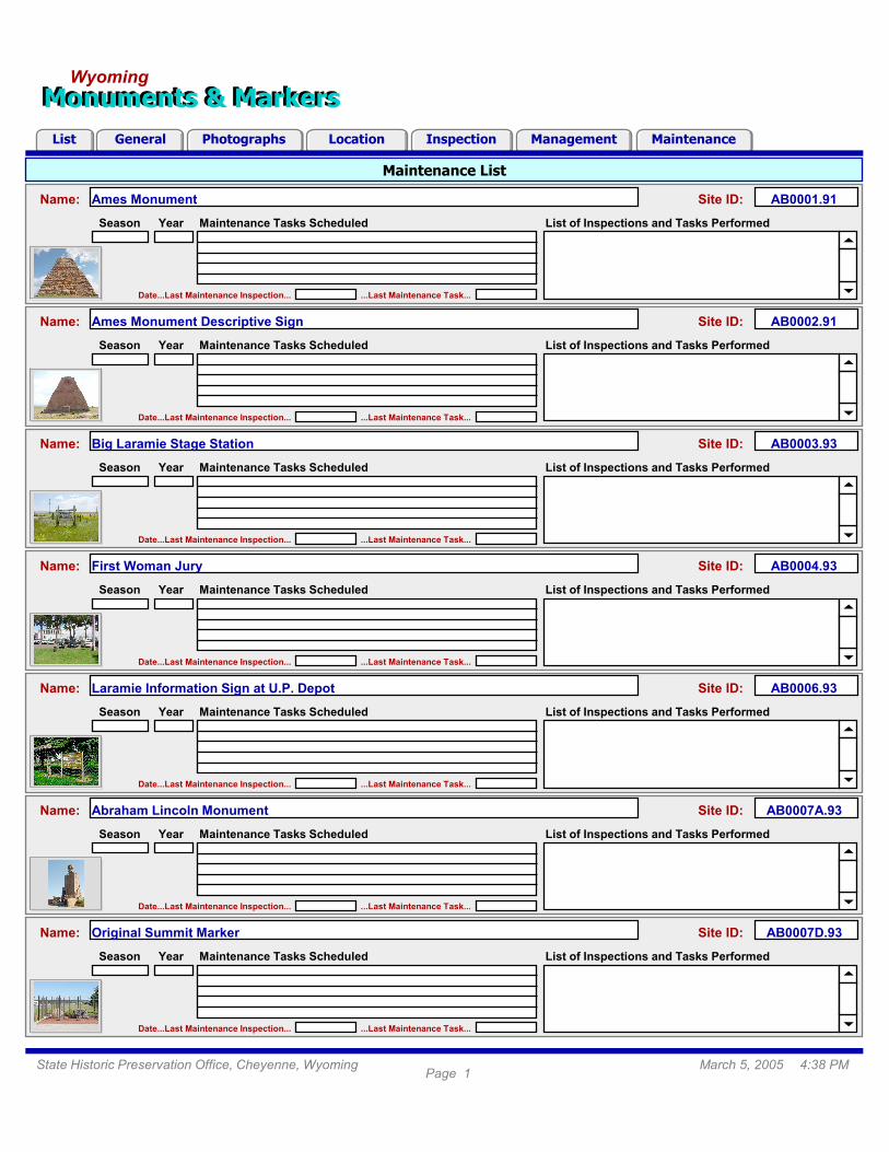
Maintenance List
Monuments & MarkersMonuments & MarkersWyoming
MaintenanceInspectionLocationGeneral ManagementPhotographsList
Maintenance Tasks Scheduled List of Inspections and Tasks PerformedSeason Year
Date...Last Maintenance Inspection... ...Last Maintenance Task...
Ames MonumentName: AB0001.91Site ID:
Maintenance Tasks Scheduled List of Inspections and Tasks PerformedSeason Year
Date...Last Maintenance Inspection... ...Last Maintenance Task...
Ames Monument Descriptive SignName: AB0002.91Site ID:
Maintenance Tasks Scheduled List of Inspections and Tasks PerformedSeason Year
Date...Last Maintenance Inspection... ...Last Maintenance Task...
Big Laramie Stage StationName: AB0003.93Site ID:
Maintenance Tasks Scheduled List of Inspections and Tasks PerformedSeason Year
Date...Last Maintenance Inspection... ...Last Maintenance Task...
First Woman JuryName: AB0004.93Site ID:
Maintenance Tasks Scheduled List of Inspections and Tasks PerformedSeason Year
Date...Last Maintenance Inspection... ...Last Maintenance Task...
Laramie Information Sign at U.P. DepotName: AB0006.93Site ID:
Maintenance Tasks Scheduled List of Inspections and Tasks PerformedSeason Year
Date...Last Maintenance Inspection... ...Last Maintenance Task...
Abraham Lincoln MonumentName: AB0007A.93Site ID:
Maintenance Tasks Scheduled List of Inspections and Tasks PerformedSeason Year
Date...Last Maintenance Inspection... ...Last Maintenance Task...
Original Summit MarkerName: AB0007D.93Site ID:
Page 1March 5, 2005 4:38 PMState Historic Preservation Office, Cheyenne, Wyoming

Monuments & MarkersMonuments & MarkersWyoming
MaintenanceInspectionLocationGeneral ManagementPhotographsList
Wyoming's Monuments and Markers DatabasePage 1--Contens and Organization
The Monuments and Markers Database is a comprehensive storage, retrieval, and management system for information
about Wyoming’s historical monuments and markers. The database includes relational data tables, tabbed layouts,
scripts, and linked photos and maps that run within the FileMaker Pro 7 software environment. Folder-like tabs give
easy access to layouts for entering, editing, viewing, and retrieving information. Control icons and buttons allow users
to find, view, print, and export data for all or a selected set of monument and marker sites in the database.
Seven primary layouts provide access to the information content of the database. Click a tab to access the layout. Click
the “Help” icon on any layout to open this help page. Click Help Page buttons 1-5 (at top) for more help. Similar icon-
and button-like controls and pop-up-help tips are provided throughout the database.
Layouts
List: Displays lists of monument and marker sites with general location, inspection, and management information. Use
this layout to search by Name or Site ID using the “Find” icon; to list all sites in the database using the “Show All” icon;
to sort site lists by Site ID, Name, or Data/Time using the “Sort Records” controls; or to print site lists and data sheets
using the “Print” icon and “Data Sheet” button. Select a site by clicking on it. A black vertical bar appears along the left
side. Go to other layouts for additional information about the site by clicking on the different layout tabs.
General: Displays physical, thematic, and historic information for each site. Use this layout for Name, Site ID, Type,
Material, Size, Physical Description, Theme, and Historical Information about the placement of the site. A site photo
(Photo 1) is also displayed. On this, and other layouts, click the photo to quickly jump to the “Photographs” layout.
Photographs: Displays photo and legend information for each site. Use this layout to store (view) up to six photos per
site with date and caption. Legend text is shown above the Legend photo (Photo 3). Click the “Zoom” button above
each photo for a larger view. Click “Additional Photos” (A) (B) (C) to view. Click “Return” button to return.
Location: Displays location and map information for each site. Use this layout for information about a site’s geographic
location (County, City, Highway, Road, and Milepost); its map coordinates (PLSS, Latitude / Longitude, UTM Northing /
Easting, and Elevation); driving directions; and other location information. Click “Zoom Map” button for a larger view of
the map. Click “Return” button to return. Insert a “Site Plan,” if available, or Location Notes and Comments. Click the
“Export Data” button to export site locations to file for GIS mapping [see Help Page 4 for more information].
Inspection: Displays inspection information for each site based on the last site visit. Use this layout for Condition and
Recommendation information including Rating, Condition Description, Inspection Date, Action(s) needed, and if (and
when) Replacement is required. Add Comments, Suggestions, Thoughts regarding site condition and
recommendations in text box. Add Reviewer’s Name and Review Date near base of layout.
Management: Displays ownership, responsibility, and insurance information for each site. Use this layout for Land
Ownership, Sign Ownership, Responsibility, and Insurance information. Add Department Memo information in text box.
Reviewer’s Name and Review Date are displayed near base of layout.
Maintenance: Displays maintenance information for each site. Use this layout for Maintenance Issues, Annual
Maintenance Tasks, Maintenance Schedules and Costs, and to track the Maintenance Histories of sites. Included are:
Date of Last Maintenance Inspection and Date of Last Task Performed. Click “View Maintenance List” button for a list
of sites with Maintenance Tasks Scheduled and Tasks Performed. Click “Return” button to return.
2 3 41 5

Monuments & MarkersMonuments & MarkersWyoming
MaintenanceInspectionLocationGeneral ManagementPhotographsList
Wyoming's Monuments and Markers DatabasePage 2--How to Use the Database (Part I: Enter, Edit, and Find)
The Monuments and Markers Database was designed around a set of common tasks. These include: add and delete
site records; enter and edit site information; find sites and specific information; view, sort, and print site records; view
photographs and maps; add, replace, and modify photographs; and import and export maps, map data and objects.
Descriptions of how to perform these tasks are provide below and on Help Pages 3-5. Examples are given to illustrate
the design function of the database. Once familiar with these tasks, more advanced operations can be performed using
the FileMaker Pro 7 (FMP7) software tools.
Add and Delete Site Records:
The database administrator can add and delete site records using the "Add" and "Delete" icons ("General" layout) or
the FMP7 tools from the “Records” pull-down menu. To add a site record, click the "Add New Record" icon. Enter a
Name for the site, press [Tab] and add a Site ID number. Fill in the remaining information and proceed to other layouts
to enter additional site information. To delete an existing site record, click the "Delete Record" icon. Warning: Deleting
a record will permanently remove the site and all of its data from the database. Select sites for deletion wisely!
Note: The database opens to the "General" layout. When entering a new site, or editing existing site data, you should start with the
information provided on this layout. Next, enter (edit) information displayed on the remaining layouts, moving from left to right. This
is important because some entries (e.g., a site’s Name and Site ID) are automatically entered into the display fields of succeeding
layouts based on information entered on preceding layouts.
Enter and Edit Site Information:
Information is entered and edited on layouts using roll-down lists, check boxes, and by typing entries directly into the
text boxes and number or date fields. Click in and out of these boxes and fields to enter information. Press the [Tab]
key to move to the next field or the [Enter] key in date fields. For other data types, such as maps, photos, and objects,
click the “Help” icons, located adjacent to these objects, or see Help Page 4 for more information.
Notes: (1) The item “Other” in check box sets is used to enter a new list item. These lists are generated based on the actual data
contained in the field for all sites in the database. After a new item is entered it will be available as a selection choice for other sites
in the database. (2) Many of the roll-down lists are also dynamically created from data in the database, while others are based on
set “Value Lists”. Roll-downs based on Value Lists have an item named “Edit…” at the end of the list. Use this to add, delete, or edit
the list. For dynamically created roll-down lists you can simply add a new item to the list by typing it into the field.
Find Sites and Specific Information:
Click the “Find” icon at top of layouts to locate specific sites, groups of sites, or specific information. Click inside of a
field of interest and select a check box or roll-down item, or enter a date or text as your search criteria. T o perform the
search click the “Find” button in FMP7 control panel at left. The number of sites matching the search request is shown
in control panel. Use control panel to move through the found set. Use “List” layout to view and print site lists or to sort
sites based on Site ID, Name, or Date/Time. You can also find sites based on one or more search criteria.
Note: Date/Time in "List" layout refers to auto-entered values that track changes in the database. These values are displayed in site
lists and on Data Sheets. The Date/Time sort is in reverse chronological order (i.e., site most recently modified at top).
Examples: (1) To find all sites with “Fort” in their name, type “Fort” into the Name field (no quotes) and click the Find button. (2) To
find all sites located in Albany County and on Interstate 80, select "Albany" and then select "I-80" from the roll-down lists for the
“County" and “Road” fields on the “Location” layout, respectively, and click the Find button.
2 3 41 5

Monuments & MarkersMonuments & MarkersWyoming
MaintenanceInspectionLocationGeneral ManagementPhotographsList
Wyoming's Monuments and Markers DatabasePage 3--How to Use the Database (Part II: View, Sort, and Print)
View, Sort, and Print Site Records:
Each layout displays different thematic information for a site. Click the folder-like tabs to view the layouts. Use the
FMP7 control panel (at left) from within a layout to move from one site to the next, or use the tabs to view the different
thematic data for a single site. Use the “List” layout to view, sort, and print lists of more than one site, for example, a
group of sites (the found set) resulting from a search request. Sort the list of sites quickly based on Site ID, Name, or
Date/Time using the “Sort Records” controls, or perform more complex sorts using the “Sort Records…” tool from the
FMP7 “Records” pull-down menu. On the “List” layout, click the “Data Sheet” button to view and print a formatted data
sheet for each site. The Data Sheet displays a synopsis of pertinent data for each site. Use the print preview tool from
the FMP7 control panel to view any of the layouts before printing. Click “Print” icon (top of layouts) to print, or use the
“Print…” tool from the FMP7 “File” pull-down menu. The “Show All” icon in “List” layout is useful for deselecting a found
set so that all site records in the database are listed. Use the FMP7 “Zoom” tools (below control panel), or from the
“View” pull-down menu to zoom in and out on any of the layouts. These tools can be used in combination with the
“Zoom” buttons in the database to, for example, view the photos in considerable detail.
Notes: (1) If FMP7 control panel is not open, click to view “Status Area” [Ctrl+Alt+S] from the FMP7 “View” pull-down menu to open.
(2) Printing: The layouts were designed to fit a standard letter-size page. Select “Current Record” or “Records being browsed”
option. To print a Data Sheet for a single site, for example, use the “Current Record” option.
View Photographs and Maps:
The "Photographs" and "Location" layouts can display up to six photographs, two maps, and a site plan for each site.
Photographs: Site photos are organized on the “Photographs” layout as follows:
Photo 1, with date and caption, is the primary photograph for the site. It is displayed in the upper, right corner on the
"Photographs" layout and on most of the other principal layouts in the database.
Photo 2, with date and caption, is the secondary photograph for the site. It is displayed in the lower, right corner on the
"Photographs" layout and is generally a close-up or alternate view of the site.
Photo 3, with date and “Legend Text,” is a close-up view of the text printed on the monument, marker, plaque, or sign.
It is displayed in the lower, left corner, while the “Legend Text” is shown above in the upper, left corner of the layout.
Additional Photos (optional): Three small photo frames appear at the lower, right on the “Photographs” layout. These
are used to store and view up to three optional photos of the site. A small thumbnail view of the photo indicates that an
optional photograph is available. Click frame (A) (B) or (C) to view the photo. From this large view layout of the photo a
date and caption can be entered or viewed. Additional photos are commonly used to store alternate views of the site or
photos of damage to site features that need maintenance attention. Click “Return” button to return.
Maps: On the “Location” layout, an Index Map and County Map are shown for each site at top, right. The Index Map
highlights the county. The County Map shows the locations of all sites in the county with Site ID labels. The map base
is a shaded relief view of topography. A “Site Plan” for the site is displayed, if available, at bottom, right.
Zoom: Click the “Zoom” button above each photo on the “Photographs” layout or to the left of the County Map on the
“Location” layout for a larger view. The “Zoom” button tools open new layouts where the photos and maps are display
at full resolution. Click “Return” button to return. Optional: Use the FMP7 zoom tools (lower left) to zoom in on these
layouts further to as much as 400%.
2 3 41 5

Monuments & MarkersMonuments & MarkersWyoming
MaintenanceInspectionLocationGeneral ManagementPhotographsList
Wyoming's Monuments and Markers DatabasePage 4--How to Use the Database (Part III: Photographs)
Photographs:
The photographs displayed in the database are linked to each site record using a "reference to the file" approach. This
means that the photos are not directly inserted (or stored) in the database. Instead, a "pointer" to a photo file is made
and stored. Advantages of this approach are a smaller, faster database and easy updates. Disadvantages are that no
changes can be made to a file’s name or location (folder) because this will sever the link to the photo; and any photo
added to the database for an existing site or new site must be correctly named and placed in a specific folder. File
folder and file name conventions used for the database are outline below:
File Folders: Photographs, up to six per site, are stored in six separate subfolders within the folder that contains the
database. These subfolders are named Pic1, Pic2, Pic3, PicA, PicB, and PicC; and are used to store Photo 1, Photo 2,
Photo 3, and optional photos A, B, and C, respectively.
File Names: Photographs are uniquely named based on the monument or marker Site ID and the photo number (letter)
in the database. Using this naming convention every photo file in the database will have a specific file name. Thus, for
Ames Monument, which has Site ID AB0001.91 and six photos, the files are named and located as follows:
Photo 1 is stored and linked as file AB0001_91_P1.JPG in subfolder Pic1
Photo 2 is stored and linked as file AB0001_91_P2.JPG in subfolder Pic2
Photo 3 is stored and linked as file AB0001_91_P3.JPG in subfolder Pic3
Photo A is stored and linked as file AB0001_91_PA.JPG in subfolder PicA
Photo B is stored and linked as file AB0001_91_PB.JPG in subfolder PicB
Photo C is stored and linked as file AB0001_91_PC.JPG in subfolder PicC
Notes: (1) Notice that the period in the Site ID is replaced with an underscore character “_” and that a second “_” is placed before
the picture (P) and number (or letter) designation. (2) JPEG (JPG) files are common digital photograph file types, but the container
fields of FMP7 can hold other file types such as GIF, BMP, TIF, etc. (3) Instant Web Publishing, the FMP7 feature that enables the
Monument and Markers Database to be accessed over the Internet, requires that the database be located in the “C:\Program
Files\FileMaker\FileMaker Pro 7\Web” folder. Therefore, the photo subfolders Pic1, Pic2… are located in this “…Web” folder.
Add, Replace, and Modify Photographs:
Existing Sites: For the 467 sites in the database, as of Feb 25, 2005, either an “actual” or “dummy” photo file was used
to populate the database (a total of 2,802 photos). Each photo subfolder therefore contains a photo file for every site,
whether or not an actual photo exists. The “dummy” photos are essentially placeholders that display throughout the
database as blank gray backgrounds with the words “Photograph Not Available” written in the center. To add an actual
photo for one of these sites simply name the actual photo file, as outlined above, and copy it over the “dummy” file in
the correct subfolder. The database will automatically display the new photo the next time the site is viewed. Use this
same approach to replace an old photo with a new one, or to modify an existing photo; in the latter case, the photo file
can simply be opened, modified, and saved. The database will automatically display the updated photo.
New Sites: When a new site record is created, photos for the site can be named and placed into the photo subfolders
using the naming and placement conventions outline above. Then, from within the Monument and Markers Database
using FMP7, right click each photo frame, select [Insert Picture...] from the pop-up menu, navigate to the appropriate
folder (Pic1, Pic2…), and select the new photo file for the site by name. Make sure “Store only a reference to the file” is
selected at the bottom of the dialog [the default setting] and click the “Open” button. This will insert the photo using the
reference to the file. Complete the task by adding a photo date and caption (or Legend Text) into the appropriate fields
on the “Photographs” layout. Note: Only the database administrator should perform this task.
2 3 41 5

Monuments & MarkersMonuments & MarkersWyoming
MaintenanceInspectionLocationGeneral ManagementPhotographsList
Wyoming's Monuments and Markers DatabasePage 5--How to Use the Database (Part IV: Maps, Map Data, Objects)
Maps:
The “Location” layout displays a Wyoming Index Map and a County Map for each site. These maps are GIF and JPG
image files, respectively, and are stored in the “Maps” subfolder. Similar to photos in the database, the “reference to
the file” link displays these maps for associated sites based on the “County” selected for the site. However, unlike the
photos, the map file references are store in a separate related data table named MM_Maps. This table contains 23
records, one for each county, and is linked to MM_Main, the primary data table for the database, via the “County” field,
which is present in both tables. Thus, a site located in Albany County will show the index map file (Indx_Albany.gif) and
county map file (Albany.jpg) because “Albany” is selected in the “County” field.
Map Updates: To update the maps in the database, create or acquire new map files; name the files according to the
naming conventions outlined above; and copy the files over the existing files. The database will automatically display
the new maps. Note: Only the database administrator should perform this task.
Site Plans:
A “Site Plan” for each site is stored in the MM_Main data table so that each site can have a unique site plan. To add a
site plan simply create or acquire a site plan file (JPG, GIF, BMP, TIF, etc.) and copy it to the “Site_Plan” subfolder.
Then, from within the Monument and Markers Database using FMP7, go to the “Location” layout for the site; right click
the “Site Plan” frame; select [Insert Picture...] from the pop-up menu; navigate to the “Site_Plan” subfolder; and select
the file. Make sure “Store only a reference to the file” is selected at the bottom of the dialog [the default setting] and
click the “Open” button. This will insert the Site Plan as a reference to the file. Note: Only the database administrator
should perform this task.
Export Map Data:
Location data, useful for GIS mapping, can be easily exported to file in tabular format for all or a selected set of sites in
the database. Simply click the “Export Data” button on the “Location” layout; navigate to the desired folder; select a file
type (dBase DBF recommended); enter a name for the file; and click the “Save” button. Site records are sorted by Site
ID and exported to file. Exported data include: Site ID, Name, PLSS T/R/S, Latitude/Longitude, UTM Northing/Easting,
and other geographic information, as well as Type, Material, Inspection Date, and Ownership and Responsibility. To
export data for a selected set of sites in the database make the selection before performing the export.
Notes: (1) A dBase (DBF) file can be directly opened in ArcGIS v. 9x as a data table. Map the site locations as events using either
the Latitude/Longitude (WGS84) coordinates or the UTM Northing/Easting (NAD83) coordinates. (2) UTM coordinates are Zone 12
(west of longitude -108) and Zone 13 (east of longitude -108). Zone designation is also output to file.
Sounds, Files, and Objects:
Sound recordings, external files, and linked objects can be imported as “Maintenance Procedures” for each site on the
“Maintenance” layout. Right click “Procedure 1” or “Procedure 2” and select "Insert Sound," "Insert File," or "Insert
Object" from the pop-up menu. To record a sound clip, click the record button. To insert a file, browse to and select the
file to import. To insert an object, select Object Type from the menu and click either “Create New” or “Create from File”
for the document type associated with the external software package. Double click or right click the frames to hear or
view the contents. Images, video and sound clips, text and spreadsheet documents, slide shows, and presentations
can be inserted. Note: Ask the database administrator for assistance.
2 3 41 5