Embed Size (px)
Citation preview

May 2016
1
MODEL ORDINANCE FOR
EROSION AND SEDIMENT CONTROL
WHEREAS, soil is most vulnerable to erosion by wind and water during soil disturbing activities
and this eroded soil necessitates repair of sewers and ditches and dredging of rivers, harbors, and lakes;
accelerates downstream bank erosion and damage to public and private property; damages water resources
and wetlands by reducing water quality; and causes the siltation of aquatic habitat; and
WHEREAS, communities throughout the watershed(s) in which the [community] is located have
experienced and continue to experience costs associated with inadequate erosion and sediment control and
increased State and Federal regulation; and
PLEASE NOTE
Ohio EPA’s Phase II Program requires erosion and sediment control and post-construction
stormwater management. This model ordinance ONLY addresses the construction site erosion
and sediment control portion of these NPDES requirements. Phase II communities must
implement separate post-construction stormwater management regulations under their Phase II
Stormwater Management Programs. This model was updated to include changes to Ohio EPA’s
erosion and sediment control requirements in Ohio EPA Permit #OHC000004 effective April
21, 2013.
As detailed in Section XXXX.06, this model ordinance relies on county soil and water
conservation districts for plan review in conjunction with community engineers. Please review
these roles in your community and adjust the language in this model code accordingly.
All areas highlighted in bold/italics must be addressed and/or adjusted when tailoring this model
to your community.
All definitions should be reviewed for consistency with other code provisions when tailoring
this model to your community.
Text highlighted yellow must be added and red strikethrough text deleted to maintain
compliance with Ohio EPA Permit #OHC000004 effective April 21, 2013. CRWP
recommendations to assist communities with improving stormwater management are
highlighted green. Adopting these recommendations may help communities address the Total
Maximum Daily Load (TMDL) requirements of their Municipal Separate Storm Sewer (MS4)
permit.
“Storm water” has been replaced with “stormwater” throughout the model code.
This model is a collaborative effort of CRWP and the Lake County Soil and Water Conservation
District and has been reviewed for Phase II compliance by Ohio EPA. Funding for revisions to
create the 2015 version of this model code was provided by the National Estuarine Research
Reserve System Science Collaborative and the Lake Erie Protection Fund. The monies for the
LEPF are supported by citizens of Ohio through their purchase of the Lake Erie License Plate.

May 2016
2
WHEREAS, there are watershed-wide efforts to reduce sedimentation in the [rivers to which
community drains] and to protect and enhance the unique water resources or wetlands of the [rivers to
which community drains] watershed(s);
WHEREAS, the United States Environmental Protection Agency has approved a Total Maximum
Daily Load for [applicable TMDLs] in the [rivers to which community drains] watershed(s); [Use the
TMDL Community Identifier Table at http://www.neohiostormwater.com/to identify
applicable TMDLs for your community]
WHEREAS, the [community] is a member of the (insert names of watershed organizations or
utilities in which the community is participating. Remove this statement if there is no participation) and
recognizes its obligation as a part of these watersheds/organizations to reduce sedimentation and to protect
water quality by controlling soil disturbing activities within its borders; and
WHEREAS, 40 C.F.R. Parts 9, 122, 123 and 124, referred to as NPDES Stormwater Phase II, require
designated communities, including the [community] to develop and implement a Stormwater Management
Program to address, among other components, erosion and sediment control during soil disturbing
activities; and
WHEREAS, Article XVIII, Section 3 of the Ohio Constitution grants municipalities the legal
authority to adopt rules to abate soil erosion and water pollution by soil sediments; and
NOW, THEREFORE BE IT ORDAINED by the Council of [community], county of [county],
State of Ohio, that:
SECTION 1: Codified Ordinance Chapter XXXX Erosion and Sediment Control, is hereby adopted to
read in total as follows:
CHAPTER XXXX
EROSION AND SEDIMENT CONTROL
XXXX.01 PURPOSE AND SCOPE
(a) The purpose of this regulation is to establish technically feasible and economically
reasonable standards to achieve a level of erosion and sediment control that will
minimize damage to property and degradation of water resources and wetlands, and will
promote and maintain the health and safety of the citizens of [community]:
(b) This regulation will:
(1) Allow development while minimizing increases in erosion and sedimentation.
(2) Reduce water quality impacts to receiving water resources and wetlands that may be
caused by new development or redevelopment activities.
(c) This regulation applies to all parcels used or being developed, either wholly or partially,
for new or relocated projects involving highways, underground cables, or pipelines;
subdivisions or larger common plans of development; industrial, commercial,
institutional, or residential projects; building activities on farms; redevelopment
activities; general clearing; and all other uses that are not specifically exempted in
Section XXXX.01 (d).

May 2016
3
(d) This regulation does not apply to activities regulated by, and in compliance with, the
Ohio Agricultural Sediment Pollution Abatement Rules.
XXXX.02 DEFINITIONS
For purpose of this regulation, the following terms shall have the meaning herein indicated:
(a) ABBREVIATED STORMWATER POLLUTION PREVENTION PLAN (ABBREVIATED
SWP3): The written document that sets forth the plans and practices to be used to meet the
requirements of this regulation. [Lake County Communities – replace Stormwater Pollution
Prevention Plan with Erosion and Sediment Control Plan]
(b) ACRE: A measurement of area equaling 43,560 square feet.
(c) ADMINISTRATOR: The person or entity having the responsibility and duty of administering and
ensuring compliance with this regulation.
(d) BEST MANAGEMENT PRACTICES (BMPs): Also STORMWATER CONTROL MEASURE
(SCM). Schedule of activities, prohibitions of practices, maintenance procedures, and other
management practices (both structural and non-structural) to prevent or reduce the pollution of
water resources and wetlands. BMPs also include treatment requirements, operating procedures,
and practices to control facility and/or construction site runoff, spillage or leaks, sludge or waste
disposal; or drainage from raw material storage.
(e) COMMENCEMENT OF CONSTRUCTION: The initial disturbance of soils associated with
clearing, grubbing, grading, placement of fill, or excavating activities or other construction
activities.
(f) COMMUNITY: Throughout this regulation, this shall refer to [community], its designated
representatives, boards, or commissions.
(g) CONCENTRATED STORMWATER RUNOFF: Any stormwater runoff that flows through a
drainage pipe, ditch, diversion, or other discrete conveyance channel.
(h) CONSTRUCTION ENTRANCE: The permitted points of ingress and egress to development
areas regulated under this regulation.
(i) [Lake County Communities] CRITICAL AREA: Any area the disturbance of which would cause
soil erosion and sediment runoff and damage to private properties, water courses, storm sewers or
public lands due to topography, soil type, hydrology, or proximity to a water course. These areas
include, but are not limited to, riparian areas, wetlands, and highly erodible soils.
(j) DEVELOPMENT AREA: A parcel or contiguous parcels owned by one person or persons, or
operated as one development unit, and used or being developed for commercial, industrial,
residential, institutional, or other construction or alteration that changes runoff characteristics.
(k) DEWATERING VOLUME: See current Ohio Rainwater and Land Development Manual.
(l) DISCHARGE: The addition of any pollutant to surface waters of the state from a point source.
(m) DISTURBANCE: Any clearing, grading, excavating, filling, or other alteration of land surface
where natural or man-made cover is destroyed in a manner that exposes the underlying soils.

May 2016
4
(n) DISTURBED AREA: An area of land subject to erosion due to the removal of vegetative cover
and/or soil disturbing activities such as grading, excavating, or filling.
(o) DRAINAGE: (1) The area of land contributing surface water to a specific point. (2) The removal
of excess surface water or groundwater from land by surface of subsurface drains.
(p) DRAINAGE WATERSHED: (1) The area of land contributing surface water to a specific point
or BMP. This includes any off-site drainage.(2) The removal of excess surface water or
groundwater from land by surface or subsurface drains. For the purpose of this regulation the total
contributing drainage area to a BMP, i.e., the “watershed” directed to the practice. This includes
offsite contributing drainage.
(q) DRAINAGE WAY: A natural or manmade channel, ditch, or waterway that conveys surface
water in a concentrated manner by gravity.
(r) EROSION: The process by which the land surface is worn away by the action of wind, water, ice,
gravity, or any combination of those forces.
(s) EROSION AND SEDIMENT CONTROL: The control of soil, both mineral and organic, to
minimize the removal of soil from the land surface and to prevent its transport from a disturbed
area by means of wind, water, ice, gravity, or any combination of those forces.
(t) [Lake County Communities]: EROSION AND SEDIMENT CONTROL PLAN: The written
document meeting the requirements of this regulation which sets forth the plans and practices to
be used to minimize soil erosion and prevent off-site disposal of soil sediment by containing
sediment on-site or bypassing sediment-laden runoff through a sediment control measure during
and after land development.
(u) FINAL STABILIZATION: All soil disturbing activities at the site have been completed and a
uniform perennial vegetative cover with a density of at least 80% coverage for the area has been
established or equivalent stabilization measures, such as the use of mulches or geotextiles, have
been employed. In addition, all temporary erosion and sediment control practices are removed
and disposed of and all trapped sediment is permanently stabilized to prevent further erosion.
Final stabilization also requires the installation of permanent (post-construction) stormwater
control measures (SCMs).
(v) GRADING: The excavating, filling, or stockpiling of earth material, or any combination thereof,
including the land in its excavated or filled condition.
(w) GRUBBING: removing or grinding of roots, stumps and other unwanted material below existing
grade.
(x) IMPERVIOUS: That which does not allow infiltration.
(y) LANDSCAPE ARCHITECT: A Professional Landscape Architect registered in the State of Ohio.
(z) LARGER COMMON PLAN OF DEVELOPMENT OR SALE: A contiguous area where
multiple separate and distinct construction activities may be taking place at different times on
different schedules under one plan.

May 2016
5
(aa) MAXIMUM EXTENT PRACTICABLE (MEP): The level of pollutant reduction that site owners
of small municipal separate storm sewer systems regulated under 40 C.F.R. Parts 9, 122, 123, and
124, referred to as NPDES Stormwater Phase II, must meet. The technology-based discharge
standard for Municipal Separate Storm Sewer Systems to reduce pollutants in storm water
discharges that was established by the Clean Water Act §402(p). A discussion of MEP as it
applies to small MS4s is found in 40 CFR 122.34.
(bb)MUNICIPAL SEPARATE STORM SEWER SYSTEM (MS4): A conveyance or system of
conveyances (including roads with drainage systems, municipal streets, catch basins, curbs,
gutters, ditches, man-made channels, or storm drains) that are:
a. Owned or operated by the federal government, state, municipality, township, county,
district, or other public body (created by or pursuant to state or federal law) including a
special district under state law such as a sewer district, flood control district or drainage
districts, or similar entity, or a designated and approved management agency under
Section 208 of the Federal Water Pollution Control Act that discharges into surface
waters of the state; and
b. Designed or used for collecting or conveying solely stormwater,
c. Which is not a combined sewer, and
d. Which is not a part of a publicly owned treatment works.
(cc) NPDES: NATIONAL POLLUTANT DISCHARGE ELIMINATION SYSTEM (NPDES): A
regulatory program in the Federal Clean Water Act that prohibits the discharge of pollutants into
surface waters of the United States without a permit. The national program for issuing, modifying,
revoking and reissuing, termination, monitoring and enforcing permits and enforcing pretreatment
requirements, under sections 307, 402, 318, 405 under the Clean Water Act.
(dd)OPERATOR: Any party associated with a construction project that meets either of the following
two criteria:
a. The party has operational control over construction plans and specifications, including
the ability to make modifications to those plans and specifications; or
b. The party has day-to-day operational control of those activities at a project which are
necessary to ensure compliance with A Stormwater Pollution Prevention Plan (SWP3) for
the site or other permit conditions (e.g. they are authorized to direct workers at a site to
carry out activities required by the SWP3 or comply with other permit conditions.
(ee) SITE OWNER OR OPERATOR: The owner or operator of any “facility or activity” subject to
regulation under the NPDES program.
(ff) SUBDIVISIONS, MAJOR AND MINOR: See Ohio Administrative Code 711.001 for definition.
(gg)PARCEL: Means a tract of land occupied or intended to be occupied by a use, building or group
of buildings and their accessory uses and buildings as a unit, together with such open spaces and
driveways as are provided and required. A parcel may contain more than one contiguous lot
individually identified by a ‘Permanent Parcel Number’ assigned by the [county] County
Auditor’s Office.
(hh)PERCENT IMPERVIOUSNESS: The impervious area created divided by the total area of the
project site.
(ii) PERMANENT STABILIZATION: Establishment of permanent vegetation, decorative landscape
mulching, matting, sod, rip rap, and landscaping techniques to provide permanent erosion control

May 2016
6
on areas where construction operations are complete or where no further disturbance is expected
for at least one year.
(jj) PERSON: Any individual, corporation, firm, trust, commission, board, public or private
partnership, joint venture, agency, unincorporated association, municipal corporation, county or
state agency, the federal government, other legal entity, or an agent thereof.
(kk)PHASING: Clearing a parcel of land in distinct sections, with the stabilization of each section
before the clearing of the next.
(ll) POINT SOURCE: Any discernible, confined and discrete conveyance, including but not limited
to, any pipe, ditch, channel, tunnel, conduit, well, discrete fissure, container, rolling stock,
concentrated animal feeding operation, landfill leachate collection system, vessel or the floating
craft from which pollutants are or may be discharged. This term does not include return flows
from irrigated agriculture or agricultural stormwater runoff.
(mm)PRE-CONSTRUCTION MEETING: A meeting between the [community] and all principle
parties, prior to the start of any construction, at a site that requires a Stormwater Pollution
Prevention Plan [Lake County Communities: Erosion and Sediment Control Plan].
(nn)PRE-WINTER STABILIZATION MEETING: A meeting between the [community] and all
principal parties, prior to October 1, in order to plan winter erosion and sediment controls for a
site that requires a Stormwater Pollution Prevention Plan [Lake County Communities: Erosion
and Sediment Control Plan].
(oo)PROFESSIONAL ENGINEER: A Professional Engineer registered in the State of Ohio.
(pp)QUALIFIED INSPECTION PERSONNEL: A person knowledgeable in the principles and
practice of erosion and sediment controls, who possess the skills to assess all conditions at the
construction site that could impact stormwater quality and to assess the effectiveness of any
sediment and erosion control measure selected to control the quality of stormwater discharges
from the construction activity.
(qq)RAINWATER AND LAND DEVELOPMENT: Ohio’s standards for stormwater management, land
development, and urban stream protection. The most current edition of these standards shall be
used with this regulation.
(rr) RIPARIAN AREA: The transition area between flowing water and terrestrial (land) ecosystems
composed of trees, shrubs and surrounding vegetation which serve to stabilize erodible soil,
improve both surface and ground water quality, increase stream shading and enhance wildlife
habitat.
(ss) RUNOFF: The portion of rainfall, melted snow, or irrigation water that flows across the ground
surface and is eventually conveyed to water resources or wetlands.
(tt) RUNOFF COEFFICIENT: The fraction of rainfall that will appear at the conveyance as runoff.
(uu)SEDIMENT: The soils or other surface materials that are transported or deposited by the action
of wind, water, ice, gravity, or any combination of those forces, as a product of erosion.
(vv)SEDIMENTATION: The deposition or settling of sediment.

May 2016
7
(ww)SEDIMENT SETTLING POND: A sediment trap, sediment basin or permanent basin that has
been temporarily modified for sediment control, as described in the latest edition of Rainwater
and Land Development.
(xx)SEDIMENT STORAGE VOLUME: See current edition of Rainwater and Land Development.
(yy)SETBACK: A designated transition area around water resources and wetlands that is left in a
natural, usually vegetated, state to protect the water resources and wetlands from runoff pollution.
Soil disturbing activities in this area are restricted by this regulation.
(zz) SOIL DISTURBING ACTIVITY: Clearing, grading, excavating, filling, grubbing or stump
removal that occurs during clearing or timber activities, or other alteration of the earth’s surface
where natural or human made ground cover is destroyed and that may result in, or contribute to,
erosion and sediment pollution.
(aaa)SOIL & WATER CONSERVATION DISTRICT: An entity organized under Chapter 1515 of
the Ohio Revised Code referring to either the Soil and Water Conservation District Board or its
designated employee(s). Hereafter referred to as [county] SWCD.
(bbb)STABILIZATION: The use of BMPs, such as seeding and mulching, that reduce or prevent soil
erosion by water, wind, ice, gravity, or a combination of those forces.
(ccc)STEEP SLOPES: Slopes that are 15 percent or greater in grade. NOTE: If otherwise defined in
community zoning, use community definition.
(ddd)STORMWATER POLLUTION PREVENTION PLAN (SWP3): The written document that sets
forth the plans and practices to be used to meet the requirements of this regulation. [Lake County
Communities: This typically contains the erosion and sediment control plan for the site.]
(eee)STORMWATER: Stormwater runoff, snow melt and surface runoff and drainage.
(fff)SURFACE OUTLET: A dewatering device that only draws water from the surface of the water.
(ggg)SURFACE WATERS OF THE STATE: Also Water Resource or Water Body. Anyll streams,
lakes, reservoirs, pond, marshes, wetlands, or other waterways situated wholly or partly within
the boundaries of the state, except those private waters which do not combine or affect a junction
with surface water. Waters defined as sewerage systems, treatment works or disposal systems in
Section 6111.01 of the Ohio Revised Code are not included.
(hhh)TEMPORARY STABILIZATION: The establishment of temporary vegetation, mulching,
geotextiles, sod, preservation of existing vegetation, and other techniques capable of quickly
establishing cover over disturbed areas to provide erosion control between construction
operations.
(iii) TOPSOIL: The upper layer of the soil that is usually darker in color and richer in organic matter
and nutrients than subsoil.
(jjj) TOTAL MAXIMUM DAILY LOAD: The sum of the existing and/or projected point source,
nonpoint source, and background loads for a pollutant to a specified watershed, water resource or
wetland, or water resource or wetland segment. A TMDL sets and allocates the maximum amount
of a pollutant that may be introduced into the water and still ensure attainment and maintenance
of water quality standard.

May 2016
8
(kkk)UNSTABLE SOILS: A portion of land that is identified by the [community] Engineer as prone
to slipping, sloughing, or landslides, or is identified by the U.S. Department of Agriculture
Natural Resource Conservation Service methodology as having a low soil strength.
(lll) Water Quality Volume (WQv): The volume of stormwater runoff which must be captured and
treated prior to discharge from the developed site after construction is complete. WQv is based on
the expected runoff generated by the mean storm precipitation volume from post-construction site
conditions at which rapidly diminishing returns in the number of runoff events captured begins to
occur.
(mmm)WATER RESOURCE Also SURFACE WATER OF THE STATE: Any public or private
body of water; including wetlands; the area within the ordinary high water level of lakes and
ponds; as well as the area within the ordinary high water level of any brook, creek, river, or
stream having a defined bed and bank (either natural or artificial) which confines and conducts
continuous or intermittent flow. Any stream, lake, reservoir, pond, marsh, wetland, or waterway
situated wholly or partly within the boundaries of the state, except those private waters which do
not combine or affect a junction with surface water. Waters defined as sewerage systems,
treatment works or disposal systems in Section 6111.01 of the Ohio Revised Code are not
included. WATER RESOURCE: Any public or private body of water including lakes and ponds,
as well as any brook, creek, river, or stream having banks, a defined bed, and a definite direction
of flow, either continuously or intermittently flowing.
(nnn)WATERSHED: The total drainage area contributing runoff to a single point.
(ooo)WETLAND: Those areas, that are inundated or saturated by surface or ground water at a
frequency and duration sufficient to support, and that under normal circumstances do support, a
prevalence of vegetation typically adapted for life in saturated soil conditions, including swamps,
marshes, bogs, and similar areas (40 CFR 232, as amended).
XXXX.03 DISCLAIMER OF LIABILITY
Compliance with the provisions of this regulation shall not relieve any person from responsibility for
damage to any person otherwise imposed by law. The provisions of this regulation are promulgated to
promote the health, safety, and welfare of the public and are not designed for the benefit of any individual
or for the benefit of any particular parcel of property.
May 2016
9
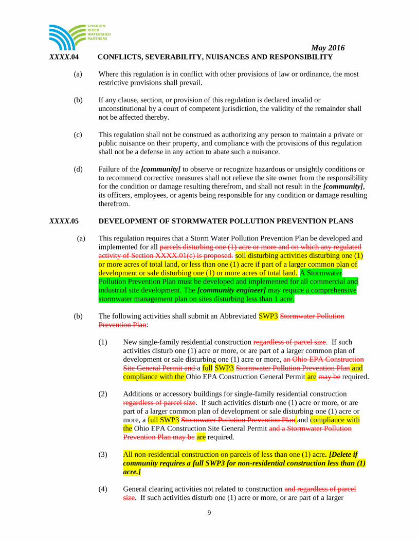
XXXX.04 CONFLICTS, SEVERABILITY, NUISANCES AND RESPONSIBILITY
(a) Where this regulation is in conflict with other provisions of law or ordinance, the most
restrictive provisions shall prevail.
(b) If any clause, section, or provision of this regulation is declared invalid or
unconstitutional by a court of competent jurisdiction, the validity of the remainder shall
not be affected thereby.
(c) This regulation shall not be construed as authorizing any person to maintain a private or
public nuisance on their property, and compliance with the provisions of this regulation
shall not be a defense in any action to abate such a nuisance.
(d) Failure of the [community] to observe or recognize hazardous or unsightly conditions or
to recommend corrective measures shall not relieve the site owner from the responsibility
for the condition or damage resulting therefrom, and shall not result in the [community],
its officers, employees, or agents being responsible for any condition or damage resulting
therefrom.
XXXX.05 DEVELOPMENT OF STORMWATER POLLUTION PREVENTION PLANS
(a) This regulation requires that a Storm Water Pollution Prevention Plan be developed and
implemented for all parcels disturbing one (1) acre or more and on which any regulated
activity of Section XXXX.01(c) is proposed. soil disturbing activities disturbing one (1)
or more acres of total land, or less than one (1) acre if part of a larger common plan of
development or sale disturbing one (1) or more acres of total land. A Stormwater
Pollution Prevention Plan must be developed and implemented for all commercial and
industrial site development. The [community engineer] may require a comprehensive
stormwater management plan on sites disturbing less than 1 acre.
(b) The following activities shall submit an Abbreviated SWP3 Stormwater Pollution
Prevention Plan:
(1) New single-family residential construction regardless of parcel size. If such
activities disturb one (1) acre or more, or are part of a larger common plan of
development or sale disturbing one (1) acre or more, an Ohio EPA Construction
Site General Permit and a full SWP3 Stormwater Pollution Prevention Plan and
compliance with the Ohio EPA Construction General Permit are may be required.
(2) Additions or accessory buildings for single-family residential construction
regardless of parcel size. If such activities disturb one (1) acre or more, or are
part of a larger common plan of development or sale disturbing one (1) acre or
more, a full SWP3 Stormwater Pollution Prevention Plan and compliance with
the Ohio EPA Construction Site General Permit and a Stormwater Pollution
Prevention Plan may be are required.
(3) All non-residential construction on parcels of less than one (1) acre. [Delete if
community requires a full SWP3 for non-residential construction less than (1)
acre.]
(4) General clearing activities not related to construction and regardless of parcel
size. If such activities disturb one (1) acre or more, or are part of a larger

May 2016
10
common plan of development or sale disturbing one (1) acre or more, compliance
with the Ohio EPA Construction Site General Permit and a full SWP3
Stormwater Pollution Prevention Plan may be are required.
(c) Activities disturbing 1/10th (one tenth) or less of an acre are not required to submit a
SWP3 Stormwater Pollution Prevention Plan or an Abbreviated SWP3 Stormwater
Pollution Prevention Plan, unless required by the [community] Engineer. These activities
must comply with all other provisions of this regulation.
XXXX.06 APPLICATION PROCEDURES
(a) SOIL DISTURBING ACTIVITIES SUBMITTING A STORMWATER POLLUTION
PREVENTION PLAN (SWP3): The applicant shall submit two (2) sets of the SWP3 and
the applicable fees to the [community] and two (2) sets of the SWP3 and the applicable
fees to the [county] SWCD as follows:
(1) For subdivisions: After the approval of the preliminary plans and with submittal
of the improvement plans.
(2) For other construction projects: Before issuance of a zoning permit by the Zoning
Inspector.
(3) For general clearing projects: Prior to issuance of a zoning permit by the Zoning
Inspector.
(b) SOIL DISTURBING ACTIVITIES SUBMITTING AN ABBREVIATED
STORMWATER POLLUTION PREVENTION PLAN (SWP3): The applicant shall
submit two (2) sets of the Abbreviated SWP3 and the applicable fees to the [community]
and two (2) sets of the Abbreviated SWP3 and the applicable fees to the [county] SWCD
as follows:
(1) For single-family home construction: Before issuance of a zoning permit by the
Zoning Inspector.
(2) For other construction projects: Before issuance of a zoning permit by the Zoning
Inspector.
(3) For general clearing projects: Prior to issuance of a zoning permit by the Zoning
Inspector.
(c) The [community engineer] and the [county] SWCD shall review the plans submitted
under XXXX.06 (a) or (b) for conformance with this regulation and approve, or return for
revisions with comments and recommendations for revisions. A plan rejected because of
deficiencies shall receive a narrative report stating specific problems and the procedures
for filing a revised plan.
(d) Soil disturbing activities shall not begin and zoning permits shall not be issued without
i. Approved SWP3 or Abbreviated SWP3
ii. Installation of erosion and sediment controls
iii. Physical marking in the field of protected areas or critical areas, including
wetlands and riparian areas

May 2016
11
(e) SWP3 for individual sublots in a subdivision will not be approved unless the larger
common plan of development or sale containing the sublot is in compliance with this
regulation.
(f) The developer, engineer and contractor, and other principal parties, shall meet with the
[community engineer] for a Pre-Construction Meeting no less than seven (7) days prior
to soil-disturbing activity at the site to ensure that erosion and sediment control devices
are properly installed, limits of disturbance and buffer areas are properly delineated and
construction personnel are aware of such devices and areas. Pre-Construction Meetings
for Abbreviated SWP3s may be waived at the discretion of the [community engineer].
(g) Approvals issued in accordance with this regulation shall remain valid for one (1) year
from the date of approval.
XXXX.07 COMPLIANCE WITH STATE AND FEDERAL REGULATIONS
Approvals issued in accordance with this regulation do not relieve the applicant of responsibility for
obtaining all other necessary permits and/or approvals from the Ohio EPA, the US Army Corps of
Engineers, and other federal, state, and/or county agencies. If requirements vary, the most restrictive
requirement shall prevail. These permits may include, but are not limited to, those listed below. All
submittals required to show proof of compliance with these state and federal regulations shall be
submitted with SWP3s or Abbreviated SWP3s.
(a) Ohio EPA NPDES Permits authorizing stormwater discharges associated with
construction activity or the most current version thereof: Proof of compliance with these
requirements shall be the applicant’s Notice of Intent (NOI) number from Ohio EPA, a
copy of the Ohio EPA Director’s Authorization Letter for the NPDES Permit, or a letter
from the site owner certifying and explaining why the NPDES Permit is not applicable.
(b) Section 401 of the Clean Water Act: Proof of compliance shall be a copy of the Ohio
EPA Water Quality Certification application tracking number, public notice, project
approval, or a letter from the site owner certifying that a qualified professional has
surveyed the site and determined that Section 401 of the Clean Water Act is not
applicable. Wetlands, and other waters of the United States, shall be delineated by
protocols accepted by the U.S. Army Corps of Engineers at the time an application is
made under this regulation.
(c) Ohio EPA Isolated Wetland Permit: Proof of compliance shall be a copy of Ohio EPA’s
Isolated Wetland Permit application tracking number, public notice, project approval, or a
letter from the site owner certifying that a qualified professional has surveyed the site and
determined that Ohio EPA’s Isolated Wetlands Permit is not applicable. Isolated wetlands
shall be delineated by protocols accepted by the U.S. Army Corps of Engineers at the
time an application is made under this regulation.
(d) Section 404 of the Clean Water Act: Proof of compliance shall be a copy of the U.S.
Army Corps of Engineers Individual Permit application, public notice, or project
approval, if an Individual Permit is required for the development project. If an Individual
Permit is not required, the site owner shall submit proof of compliance with the U.S.
Army Corps of Engineer’s Nationwide Permit Program. This shall include one of the
following:
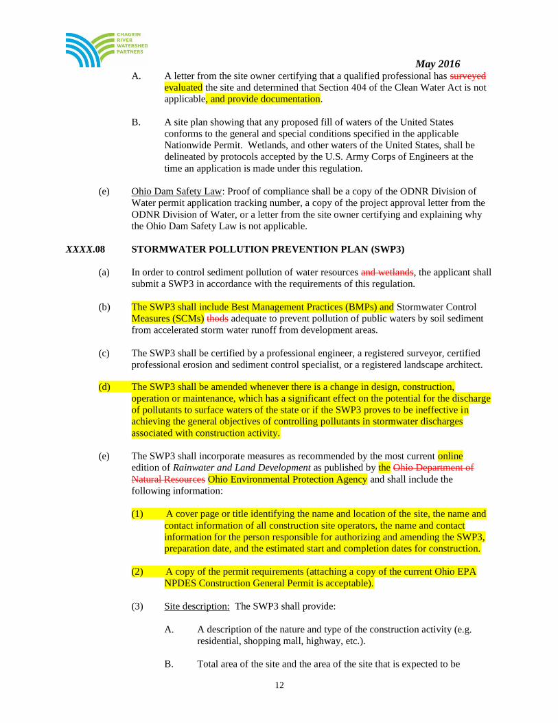
May 2016
12
A. A letter from the site owner certifying that a qualified professional has surveyed
evaluated the site and determined that Section 404 of the Clean Water Act is not
applicable, and provide documentation.
B. A site plan showing that any proposed fill of waters of the United States
conforms to the general and special conditions specified in the applicable
Nationwide Permit. Wetlands, and other waters of the United States, shall be
delineated by protocols accepted by the U.S. Army Corps of Engineers at the
time an application is made under this regulation.
(e) Ohio Dam Safety Law: Proof of compliance shall be a copy of the ODNR Division of
Water permit application tracking number, a copy of the project approval letter from the
ODNR Division of Water, or a letter from the site owner certifying and explaining why
the Ohio Dam Safety Law is not applicable.
XXXX.08 STORMWATER POLLUTION PREVENTION PLAN (SWP3)
(a) In order to control sediment pollution of water resources and wetlands, the applicant shall
submit a SWP3 in accordance with the requirements of this regulation.
(b) The SWP3 shall include Best Management Practices (BMPs) and Stormwater Control
Measures (SCMs) thods adequate to prevent pollution of public waters by soil sediment
from accelerated storm water runoff from development areas.
(c) The SWP3 shall be certified by a professional engineer, a registered surveyor, certified
professional erosion and sediment control specialist, or a registered landscape architect.
(d) The SWP3 shall be amended whenever there is a change in design, construction,
operation or maintenance, which has a significant effect on the potential for the discharge
of pollutants to surface waters of the state or if the SWP3 proves to be ineffective in
achieving the general objectives of controlling pollutants in stormwater discharges
associated with construction activity.
(e) The SWP3 shall incorporate measures as recommended by the most current online
edition of Rainwater and Land Development as published by the Ohio Department of
Natural Resources Ohio Environmental Protection Agency and shall include the
following information:
(1) A cover page or title identifying the name and location of the site, the name and
contact information of all construction site operators, the name and contact
information for the person responsible for authorizing and amending the SWP3,
preparation date, and the estimated start and completion dates for construction.
(2) A copy of the permit requirements (attaching a copy of the current Ohio EPA
NPDES Construction General Permit is acceptable).
(3) Site description: The SWP3 shall provide:
A. A description of the nature and type of the construction activity (e.g.
residential, shopping mall, highway, etc.).
B. Total area of the site and the area of the site that is expected to be

May 2016
13
disturbed (i.e., grubbing, clearing, excavation, filling or grading,
including off-site borrow areas).
C. An estimate of the impervious area and percent of imperviousness
created by the soil-disturbing land disturbance. activity.
D. A calculation of the run-off coefficients for both the pre-construction and
post-construction site conditions.
E. Existing data describing the soil and, if available, the quality of any
known pollutant discharge from the site such as that which may result
from previous contamination caused by prior land uses.
F. A description of prior land uses at the site.
G. An implementation schedule which describes the sequence of major soil-
disturbing operations (i.e., grubbing, excavating, grading, utilities and
infrastructure installation) and the implementation of erosion and
sediment controls to be employed during each operation of the sequence.
H. The location and name of the immediate receiving stream or surface
water(s) and the first subsequent receiving water(s) and the aerial extent
and description of wetlands or other special aquatic sites at or near the
site which will be disturbed or which will receive discharges from
disturbed areas of the project. For discharges to a municipal separate
storm sewer system (MS4), the point of discharge to the MS4 and the
location where the MS4 ultimately discharges to a water resource shall
be indicated.
I. List TMDLs applicable for the site and demonstrate that appropriate
BMPs or stormwater control measures (SCMs) have been selected to
address these TMDLs. [A TMDL identifier table for Northeast Ohio
communities is available at http://www.neohiostormwater.com/]
J. The aerial (plan view) extent and description of wetlands or other special
aquatic sites at or near the site which will be disturbed or which will
receive discharges from disturbed areas of the project.
K. If applicable, identify the point of discharge to a municipal separate
storm sewer system and the location where that municipal separate storm
sewer system ultimately discharges to a stream, lake, or wetland.
J. For subdivided developments where the SWP3 does not call for a
centralized sediment control capable of controlling multiple individual
lots, a detail drawing of a typical individual lot showing standard
individual lot erosion and sediment control practices. This does not
remove the responsibility to designate specific erosion and sediment
control practices in the SWP3 for areas such as steep slopes, stream
banks, drainage ways, and riparian zones.
K. Location and description of any stormwater discharges associated with
dedicated asphalt and dedicated concrete plants associated with the

May 2016
14
development area and the best management practices to address
pollutants in these stormwater discharges.
L. A log documenting grading and stabilization activities as well as
amendments to the SWP3, which occur after construction activities
commence.
M. Each temporary and permanent stormwater practice shall be designated
with an individual identification number.
N. Site map showing:
i. Limits of soil-disturbing activity of the site, including off site
spoil and borrow areas.
ii. Soils types should be depicted for all areas of the site, including
locations of unstable or highly erodible soils.
iii. Existing and proposed one-foot (1') contours. This must include
a delineation of drainage watersheds expected during and after
major grading activities as well as the size of each drainage
watershed in acres.
iv. Surface water locations including springs, wetlands, streams,
lakes, water wells, etc., on or within 200 feet of the site,
including the boundaries of wetlands or stream channels and first
subsequent named receiving water(s) the applicant intends to fill
or relocate for which the applicant is seeking approval from the
Army Corps of Engineers and/or Ohio EPA.
v. Existing and planned locations of buildings, roads, parking
facilities, and utilities.
vi. The location of all erosion and sediment control practices,
including the location of areas likely to require temporary
stabilization during the course of site development.
vii. Sediment and stormwater management basins including their
sediment settling volume and the maximum expected disturbed
area that will be directed to the sediment pond during
construction. The plan should include a summary of the
following:
i. The required sediment storage and dewatering
volumes
ii. The provided sediment storage and dewatering
volumes
iii. The weir length or skimmer size, as applicable
iv. The weir length or skimmer size provided
viii. Data sheets for all sediment traps, sediment basins, and SCMs
that identify contributing drainage area, disturbed area, water
quality volume, sedimentation volume, dewatering volume,

May 2016
15
practice surface area, facility discharge and dewatering time,
outlet type and dimensions, and any other relevant parameters
for each practice.
ix. A separate plan and profile view of each individual sediment
settling pond and its outlet structure. Detail drawings of the
outlet structure shall indicate the following elevations:
a) Pond bottom
b) Elevation required to store the required sediment storage
volume
c) For sediment basins, the elevation at which the skimmer
is attached
d) For sediment traps, the top and bottom of the stone
outlet section
e) Elevation required to store the dewatering volume,
exclusive of the sediment storage volume
f) Elevation of the top of embankment
g) Crest of the emergency spillway
x. Where used as a sediment-settling pond during construction, the
plan shall include a detail drawing of the temporary outlet
configuration of the permanent storm water basin with the
following information specified:
a) Storage volume provided below the elevation at which
the skimmer or other surface dewatering device is
attached
b) Elevation at which the skimmer or other surface
dewatering device is attached
c) Elevation at which the full dewatering zone is stored
above the skimmer invert
d) Any temporary modification to permanent outlet orifices
or weirs required to ensure no discharge below the
skimmer invert and only the skimmer controls the
discharge up to the top of the dewatering volume.
e) Calculations of the sediment storage volume, dewatering
volume and skimmer drawdown time shall also be
provided
xi. The location of permanent SCMs to be used to control pollutants
in stormwater after construction operations have been completed.
xii. Areas designated for the storage or disposal of solid, sanitary and
toxic wastes, including Dumpster dumpster areas, areas
designated for cement truck washout, and vehicle fueling.
xiii. Methods to minimize the exposure of building materials,
building products, construction wastes, trash, landscape
materials, fertilizers, pesticides, herbicides, detergents, and
sanitary waste to precipitation, stormwater runoff, and snow
melt.
xiv. Measures to prevent and respond to chemical spills and leaks.
May 2016
16
Applicants may also reference the existence of other plans (i.e.,
Spill Prevention Control and Countermeasure (SPCC) plans,
spill control programs, Safety Response Plans, etc.) provided
that such plan addresses this requirement and a copy of such plan
is maintained on site.
xv. Methods to minimize the discharge of pollutants from equipment
and vehicle washing, wheel wash water, and other wash waters.
No detergents may be used to wash vehicles. Wash waters shall
be treated in a sediment basin or alternative control that provides
equivalent treatment prior to discharge.
xvi. The location of designated stoned construction entrances where
the vehicles will ingress and egress the construction site.
xvii. The location of any in-stream activities including stream
crossings.
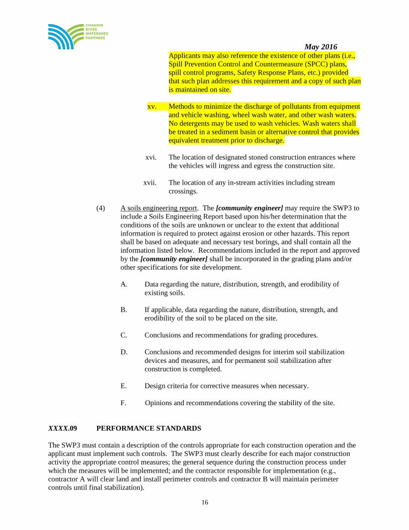
(4) A soils engineering report. The [community engineer] may require the SWP3 to
include a Soils Engineering Report based upon his/her determination that the
conditions of the soils are unknown or unclear to the extent that additional
information is required to protect against erosion or other hazards. This report
shall be based on adequate and necessary test borings, and shall contain all the
information listed below. Recommendations included in the report and approved
by the [community engineer] shall be incorporated in the grading plans and/or
other specifications for site development.
A. Data regarding the nature, distribution, strength, and erodibility of
existing soils.
B. If applicable, data regarding the nature, distribution, strength, and
erodibility of the soil to be placed on the site.
C. Conclusions and recommendations for grading procedures.
D. Conclusions and recommended designs for interim soil stabilization
devices and measures, and for permanent soil stabilization after
construction is completed.
E. Design criteria for corrective measures when necessary.
F. Opinions and recommendations covering the stability of the site.
XXXX.09 PERFORMANCE STANDARDS
The SWP3 must contain a description of the controls appropriate for each construction operation and the
applicant must implement such controls. The SWP3 must clearly describe for each major construction
activity the appropriate control measures; the general sequence during the construction process under
which the measures will be implemented; and the contractor responsible for implementation (e.g.,
contractor A will clear land and install perimeter controls and contractor B will maintain perimeter
controls until final stabilization).

May 2016
17
The approved SWP3, and the sediment and erosion controls, and non-sediment pollution controls
contained therein, shall be implemented upon the commencement of construction. Perimeter controls
must be installed two working days prior to commencement of construction. The approved plan must be
implemented until the site reaches final stabilization. All properties adjacent to the site of soil-disturbing
activity shall be protected from soil erosion and sediment run-off and damage, including, but not limited
to, private properties, natural and artificial waterways, wetlands, storm sewers and public lands.
It is the owner’s responsibility to maintain current records of contractor(s) responsible for implementation
the SWP3 and providing that information to [community engineer or administrator of code]. The SWP3
shall identify all subcontractors engaged in activities that could impact stormwater runoff. The SWP3
shall contain signatures from all of the identified subcontractors indicating that they have been informed
and understand their roles and responsibilities in complying with the SWP3. The applicant shall review
the SWP3 with the primary contractor prior to commencement of construction activities and keep a SWP3
training log to demonstrate that this review had occurred.
Erosion and sediment controls shall be designed, installed and maintained effectively to minimize the
discharge of pollutants during the course of earth disturbing activities. The controls shall include the
following minimum components:
(a) NON-STRUCTURAL PRESERVATION MEASURES: The SWP3 must make use of practices
that preserve the existing natural condition to the maximum extent practicable. Such practices
may include preserving riparian areas, preserving existing vegetation and vegetative buffer strips,
phasing of construction operations in order to minimize the amount of disturbed land at any one
time, minimizing disturbance of steep slopes, and designation of tree preservation areas or other
protective clearing or grubbing practices. Soil compaction shall be minimized and, unless
infeasible, topsoil shall be preserved. Provide and maintain a 50-foot buffer of undisturbed
natural vegetation around surface waters of the state, or riparian or wetland setbacks, if
applicable, whichever is greater, unless maintaining this buffer is infeasible (e.g., stream
crossings for roads or utilities, or for channel and floodplain rehabilitation and restoration).
Direct stormwater to vegetated areas to increase sediment removal and maximize stormwater
infiltration.
(b) EROSION CONTROL PRACTICES: The SWP3 must make use of erosion controls that are
capable of providing cover over disturbed soils. The amount of soil exposed during construction
activity shall be minimized. A description of control practices designed to restabilize disturbed
areas after grading or construction shall be included in the SWP3. The SWP3 must provide
specifications for stabilization of all disturbed areas of the site and provide guidance as to which
method of stabilization will be employed for any time of the year. Such practices may include:
temporary seeding, permanent seeding, mulching, matting, sod stabilization, vegetative buffer
strips, phasing of construction operations, the use of construction entrances, and the use of
alternative ground cover.
Erosion control practices must meet the following requirements:
(1) Stabilization. Disturbed areas must be stabilized as specified in Tables 1 and 2
below.
Table 1: Permanent Stabilization
Area requiring permanent stabilization Time frame to apply erosion controls
Any area that will lie dormant for one year or more. Within 7 days of the most recent disturbance.
Any area within 50 feet of a stream surface water Within 2 days of reaching final grade.

May 2016
18
of the state and at final grade.
Any other areas at final grade. Within 7 days of reaching final grade within that
area.
Table 2: Temporary Stabilization
Area requiring temporary stabilization Time frame to apply erosion controls
Any disturbed area within 50 feet of a stream
surface water of the state and not at final grade.
Within 2 days of the most recent disturbance if that
area will remain idle for more than 21 14 days.
For all construction activities, any disturbed area,
including soil stockpiles that will be dormant for
more than 14 days but less than one year, and not
within 50 feet of a surface water of the state stream.
Within 7 days of the most recent disturbance within
the area.
For residential subdivisions, disturbed areas must
be stabilized at least 7 days prior to transfer of
ownership or operational responsibility.
Disturbed areas that will be idle over winter. Prior to November 1 or the onset of winter weather,
whichever occurs first. Note: Where vegetative stabilization techniques may cause structural instability or are otherwise unobtainable,
alternative stabilization techniques must be employed. These techniques may include mulching or erosion matting.
(2) Permanent stabilization of conveyance channels. Applicants shall undertake
special measures to stabilize channels and outfalls and prevent erosive flows.
Measures may include seeding, dormant seeding, mulching, erosion control
matting, sodding, riprap, natural channel design with bioengineering techniques,
or rock check dams, all as defined in the most recent edition of Rainwater and
Land Development or the Field Office Technical Guide available at
www.nrcs.usda.gov/technical/efotg/.
(c) RUNOFF CONTROL PRACTICES. The SWP3 shall incorporate measures that control
the flow volume and velocity of stormwater runoff within the site from disturbed areas so
as to prevent erosion. Peak flow rates and total stormwater volume shall be controlled to
minimize erosion and outlets, downstream channel and streambank erosion. Such
practices may include rock check dams, pipe slope drains, diversions to direct flow away
from exposed soils and protective grading practices. These practices shall divert runoff
away from disturbed areas and steep slopes where practicable. Velocity dissipation
devices shall be placed at discharge locations and along the length of any outfall channel
to provide non-erosive flow velocity from the structure to a water course so that the
natural physical and biological characteristics and functions are maintained and
protected.
(d) SEDIMENT CONTROL PRACTICES. The SWP3 shall include a description of, and
detailed drawings for, all structural practices that shall store runoff, allowing sediments to
settle and/or divert flows away from exposed soils or otherwise limit runoff from exposed
areas to minimize sediment discharges from the site. Structural practices shall be used to
control erosion and trap sediment from a site remaining disturbed for more than 14 days.
Such practices may include, among others: sediment settling ponds, silt fences, storm
drain inlet protection, and earth diversion dikes or channels which direct runoff to a
sediment settling pond. The design, installation and maintenance of erosion and sediment
controls shall address factors such as the amount, frequency, intensity and duration of
precipitation, the nature of resulting stormwater runoff, and soil characteristics, including
the range of soil particle sizes expected to be present on the site.

May 2016
19
(e) All sediment control practices must be capable of ponding runoff in order to be
considered functional. Earth diversion dikes or channels alone are not considered a
sediment control practice unless used in conjunction with a sediment settling pond.
Sediment control practices must meet the following requirements:
(1) Timing. Sediment control structures shall be functional throughout the course of
earth disturbing activity. Sediment basins and perimeter sediment barriers shall
be implemented prior to grading and within seven (7) days from the start of
grubbing. They shall continue to function until the up slope development area is
restabilized. As construction progresses and the topography is altered,
appropriate controls must be constructed or existing controls altered to address
the changing drainage patterns.
(2) Sediment settling ponds. A sediment settling pond, or equivalent best
management practice upon approval from the [community] Engineer and/or the
[county] SWCD, is required for any one of the following conditions, as
determined in Table 3 below: A. Concentrated stormwater runoff.
B. Runoff from drainage areas which exceeds the design capacity of silt
fence (see Table 3) inlet protection, or other sediment barriers;
C. Runoff from common drainage locations with 10 or more acres of
disturbed land within a common drainage area.
Sediment settling ponds shall be provided in the form of a sediment trap or
sediment basin as defined in the latest edition of Rainwater and Land
Development. The maximum allowable contributing drainage area to a sediment
trap shall be limited to less than 5 acres. Contributing drainage areas of 5 acres
or more shall be treated with a sediment basin. An equivalent best management
practice may be utilized upon approval from the [community].
The sediment-settling pond shall provide both a sediment storage zone and a
dewatering zone. The volume of the dewatering zone shall be at least 1,800
cubic feet of storage per acre of total contributing drainage area. The dewatering
structure of sediment basins shall be designed to have a minimum 48-hour drain
time for sediment basins serving a drainage area over 5 acres, and, unless
infeasible, be designed to always withdraw runoff from the surface of the pond
throughout the storm cycle. As such, a skimmer discharge device consistent
with Rainwater and Land Development shall be provided to dewater sediment
basins. Sediment traps shall also provide both a sediment storage zone and
dewatering zone, but the outlet structure shall be constructed consistent with the
specifications contained in the latest edition of Rainwater and Land
Development.
When post-construction detention/water quality ponds are to be used as
temporary sediment trapping BMPs, a skimmer discharge device consistent with
the Ohio Rainwater and Land Development Manual shall be utilized during
construction phase and until the site is deemed permanently stabilized by the

May 2016
20
[community].
The skimmer shall be designed per the equivalent requirements of sediment
basins and the operator must ensure that the outlet structure of the pond provides
an equivalent or better sediment storage zone and dewatering zone. As such,
temporarily while the site is under construction, there shall be no discharge of
runoff below the elevation required for the sediment storage zone and the
discharge of stormwater within the dewatering zone shall only occur through the
skimmer.
The volume of the sediment storage zone shall be calculated by one of the
following methods:
Method 1: The volume of the sediment storage zone shall be
1000ft3 per disturbed acre within the watershed of the basin.
Method 2: The volume of the sediment storage zone shall be the
volume necessary to store the sediment as calculated with RUSLE or
other generally accepted erosion prediction model.
When determining the total contributing drainage area, off-site areas and areas
which remain undisturbed by construction activity must be included unless runoff
from these areas is diverted away from the sediment settling pond and is not co-
mingled with sediment-laden runoff. The depth of the dewatering zone must be
less than or equal to five (5) feet. The configuration between the inlets and the
outlet of the sediment-settling pond basin must provide at least two [or four]
units of length for each one unit of width ≥ 2:1 length-to-width ratio (> 2:1
length:width ratio); however, a length to width ration of ≥ 4:1 is recommended.
Sediment must be removed from the sediment-settling pond when the design
capacity of the sediment storage zone has been completely filled by sediment
accumulations has been reduced by 40 percent. This limit is typically reached
when sediment occupies one-half of the basin depth. When designing sediment
settling ponds, the applicant must consider public safety, especially as it relates to
children, as a design factor for the sediment basin and alternative sediment
controls must be used where site limitations would preclude a safe design. The
use of a combination of sediment and erosion control measures in order to
achieve maximum pollutant removal is encouraged.
(3) Silt fence and diversions. Sheet flow runoff from denuded areas shall be
intercepted by silt fence or diversions to protect adjacent properties and water
resources from sediment transported via sheet flow. Where intended to provide
sediment control, silt fence shall be placed on a level contour and shall be
capable of temporarily ponding runoff. The relationship between the maximum
drainage area to silt fence for a particular slope range is shown in Table 3 below.
Placing silt fence in a parallel series does not extend the size of the permissible
drainage area. Stormwater diversion practices shall be used to keep runoff away
from disturbed areas and steep slopes. Such devices, which include swales, dikes
or berms, may receive stormwater runoff from areas up to 10 acres.
Table 3: Maximum Drainage Area to Silt Fence Based on Slope
Maximum Drainage Area (acres) to 100 linear
feet of silt fence
Range of slope for a drainage area (%)

May 2016
21
0.5
<2%
0.25
> 2% but < 20%
0.125
> 20% but < 50%
(4) Alternative perimeter controls for sheet flow discharges may be considered by
the [community], but their use shall not exceed the limitations indicated in Table
3 above. Detail drawings and plan notes shall specify the diameter of filter
socks, compost berms and other such alternative perimeter controls if used
instead of silt fence.
(5) Stormwater diversion practices shall be used to keep runoff away from disturbed
areas and steep slopes. Such devices, which include swales, dikes or berms, may
receive storm water runoff from areas up to 10 acres.
(6) Inlet protection. Erosion and sediment control practices, such as boxed inlet
protection, shall be installed to minimize sediment-laden water entering active
storm drain systems. All inlets receiving runoff from drainage areas of one or
more acres will require a sediment settling pond. Straw or hay bales and filter
socks around catch basins are not acceptable forms of inlet protection.
(7) Off-site tracking of sediment and dust control. Best management practices must
be implemented to ensure sediment is not tracked off-site and that dust is
controlled. These best management practices must include, but are not limited
to, the following:
A. Construction entrances shall be built and shall serve as the only
permitted points of ingress and egress to the development area. These
entrances shall be built of a stabilized pad of aggregate stone or recycled
concrete or cement sized greater than 2” in diameter, placed over a
geotextile fabric, and constructed in conformance with specifications in
the most recent edition of Rainwater and Land Development.
B. Streets and catch basins adjacent to construction entrances shall be kept
free of sediment tracked off site. Streets directly adjacent to construction
entrances and receiving traffic from the development area, shall be
cleaned daily to remove sediment tracked off-site. If applicable, the
catch basins on these streets nearest to the construction entrances shall
also be cleaned weekly and protected from sediment-laden runoff, if
feasible without posing a public safety hazard.
Based on site conditions, [community] Engineer and/or the [county]
SWCD may require additional best management practices to control off
site tracking and dust. These additional BMPs may include:
C. Fencing shall be installed around the perimeter of the development area
to ensure that all vehicle traffic adheres to designated construction
entrances.
D. Designated vehicle and wheel-washing areas. Wash water from these

May 2016
22
areas must be directed to a designated sediment trap, the sediment-
settling pond, or to a sump pump for dewatering in conformance with
Section XXXX.09 (g) of this regulation. No surfactants or detergents
may be used to wash vehicles.
E. Applicants shall take all necessary measures to comply with applicable
regulations regarding fugitive dust emissions, including obtaining
necessary permits for such emissions. The [community] Engineer and/or
the [county] SWCD may require dust controls including the use of water
trucks to wet disturbed areas, tarping stockpiles, temporary stabilization
of disturbed areas, and regulation of the speed of vehicles on the site.
(8) Surface Waters of the State protection. Construction vehicles shall avoid water
resources and wetlands. A 50 foot undisturbed natural buffer shall be provided around
surface waters of the state unless infeasible. If it is infeasible to provide and maintain
an undisturbed 50-foot natural buffer, the SWP3 shall comply with the stabilization
requirements in XXXX.09.B.1 for areas within 50 feet of a surface water or riparian or
wetland setbacks if applicable, whichever is greater; and minimize soil compaction
and, unless infeasible, preserve topsoil. [Communities with riparian and/or wetland
setbacks include the following language: If a riparian or wetland setback is greater
than 50 feet, no disturbance of natural vegetation shall occur within the riparian or
wetland setback unless a variance to the riparian or wetland setback regulation has
been granted.] If the applicant is permitted to disturb areas within 50 feet of a water
resources and wetlands, the following conditions shall be addressed in the SWP3:
A. All BMPs and stream crossings shall be designed as specified in the most
recent edition of the Rainwater and Land Development Manual.
B. Structural practices shall be designated and implemented on site to
protect water resources or wetlands from the impacts of sediment runoff.
C. No structural sediment controls (e.g., the installation of silt fence or a
sediment settling pond in-stream) shall be used in a water resources or
wetlands.
D. Where stream crossings for roads or utilities are necessary and permitted,
the project shall be designed such that the number of stream crossings
and the width of the disturbance are minimized.
E. Temporary stream crossings shall be constructed if water resources or
wetlands will be crossed by construction vehicles during construction.
F. Construction of bridges, culverts, or sediment control structures shall not
place soil, debris, or other particulate material into or close to the water
resources or wetlands in such a manner that it may slough, slip, or erode.
G. Concentrated stormwater runoff from BMPs to natural wetlands shall be
converted to diffuse flow through the use of level spreaders or other such
appropriate measure before the runoff enters the wetlands. The flow
should be released such that no erosion occurs downslope. Level
spreaders may need to be placed in series to ensure non-erosive
velocities.
May 2016
23
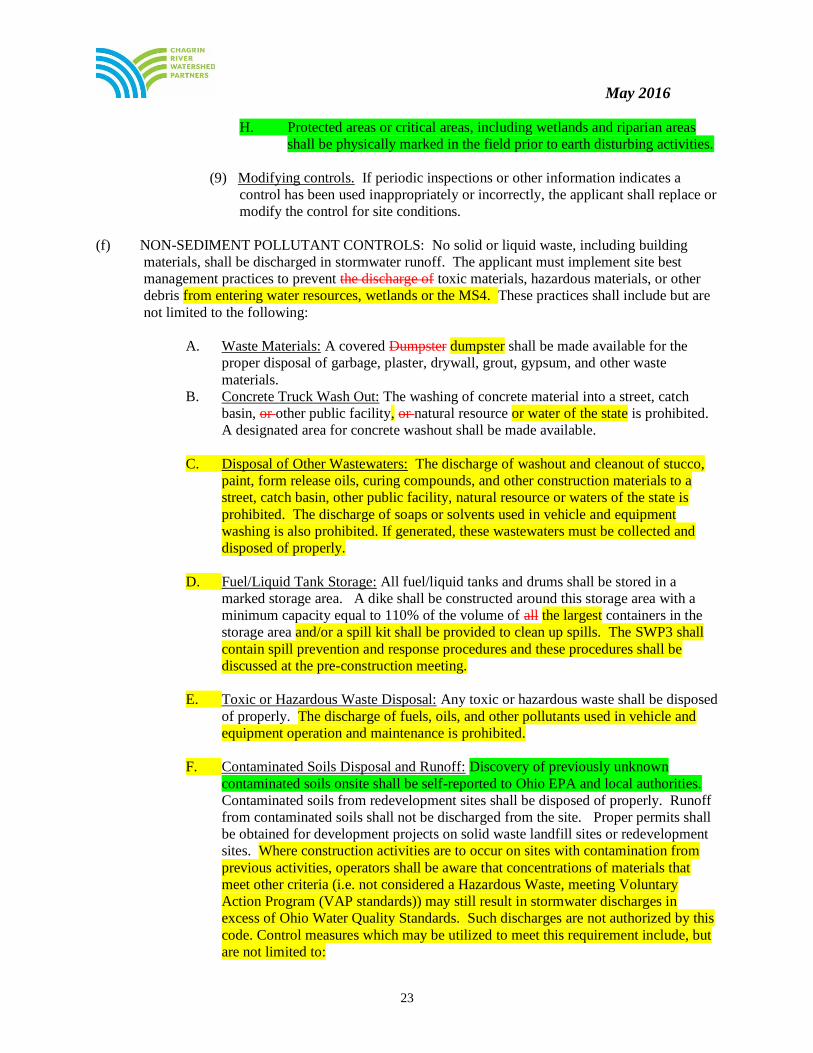
H. Protected areas or critical areas, including wetlands and riparian areas
shall be physically marked in the field prior to earth disturbing activities.
(9) Modifying controls. If periodic inspections or other information indicates a
control has been used inappropriately or incorrectly, the applicant shall replace or
modify the control for site conditions.
(f) NON-SEDIMENT POLLUTANT CONTROLS: No solid or liquid waste, including building
materials, shall be discharged in stormwater runoff. The applicant must implement site best
management practices to prevent the discharge of toxic materials, hazardous materials, or other
debris from entering water resources, wetlands or the MS4. These practices shall include but are
not limited to the following:
A. Waste Materials: A covered Dumpster dumpster shall be made available for the
proper disposal of garbage, plaster, drywall, grout, gypsum, and other waste
materials.
B. Concrete Truck Wash Out: The washing of concrete material into a street, catch
basin, or other public facility, or natural resource or water of the state is prohibited.
A designated area for concrete washout shall be made available.
C. Disposal of Other Wastewaters: The discharge of washout and cleanout of stucco,
paint, form release oils, curing compounds, and other construction materials to a
street, catch basin, other public facility, natural resource or waters of the state is
prohibited. The discharge of soaps or solvents used in vehicle and equipment
washing is also prohibited. If generated, these wastewaters must be collected and
disposed of properly.
D. Fuel/Liquid Tank Storage: All fuel/liquid tanks and drums shall be stored in a
marked storage area. A dike shall be constructed around this storage area with a
minimum capacity equal to 110% of the volume of all the largest containers in the
storage area and/or a spill kit shall be provided to clean up spills. The SWP3 shall
contain spill prevention and response procedures and these procedures shall be
discussed at the pre-construction meeting.
E. Toxic or Hazardous Waste Disposal: Any toxic or hazardous waste shall be disposed
of properly. The discharge of fuels, oils, and other pollutants used in vehicle and
equipment operation and maintenance is prohibited.
F. Contaminated Soils Disposal and Runoff: Discovery of previously unknown
contaminated soils onsite shall be self-reported to Ohio EPA and local authorities.
Contaminated soils from redevelopment sites shall be disposed of properly. Runoff
from contaminated soils shall not be discharged from the site. Proper permits shall
be obtained for development projects on solid waste landfill sites or redevelopment
sites. Where construction activities are to occur on sites with contamination from
previous activities, operators shall be aware that concentrations of materials that
meet other criteria (i.e. not considered a Hazardous Waste, meeting Voluntary
Action Program (VAP standards)) may still result in stormwater discharges in
excess of Ohio Water Quality Standards. Such discharges are not authorized by this
code. Control measures which may be utilized to meet this requirement include, but
are not limited to:

May 2016
24
i. Use berms, trenches, pits or tanks to collect contaminated runoff and
prevent discharge.
ii. Pump runoff from contaminated soils to the sanitary sewer with the prior
approval of the sanitary sewer system operator, or pump into a container
for transport to an appropriate treatment or disposal facility; and
iii. Cover areas of contamination with tarps, daily cover or other such
methods to prevent storm water from coming into contact with
contaminated materials.
The SWP3 must include methods to minimize the exposure of building materials,
building products, construction wastes, trash, landscape materials, fertilizers,
pesticides, herbicides, detergents, and sanitary waste to precipitation, stormwater
runoff, and snow melt. The SWP3 shall include measures to prevent and respond
to chemical spills and leaks. Applicants may also reference the existence of other
plans (i.e., Spill Prevention Control and Countermeasure (SPCC) plans, spill
control programs, Safety Response Plans, etc.) provided that such plan addresses
this requirement and a copy of such plan is maintained on site.
(g) COMPLIANCE WITH OTHER REQUIREMENTS. The SWP3 shall be
consistent with applicable State and/or local waste disposal, sanitary sewer, or
septic system regulations, including provisions prohibiting waste disposal by open
burning, and shall provide for the proper disposal of contaminated soils located
within the development area.
(h) TRENCH AND GROUND WATER CONTROL. There shall be no sediment-
laden or turbid discharges to water resources or wetlands resulting from
dewatering activities. If trench or ground water contains sediment, it must pass
through a sediment-settling pond or other equally effective sediment control
device, prior to being discharged from the construction site. Alternatively,
sediment may be removed by settling in place or by dewatering into a sump pit,
filter bag or comparable practice. Ground water dewatering which does not
contain sediment or other pollutants is not required to be treated prior to
discharge. However, care must be taken when discharging ground water to
ensure that it does not become pollutant-laden by traversing over disturbed soils
or other pollutant sources.
(i) INTERNAL INSPECTIONS. All controls on the site shall be inspected a at
least once every seven calendar days and within 24 hours after any storm event
greater than one-half inch of rain per 24 hour period. The inspection frequency
may be reduced to at least once every month if the entire site is temporarily
stabilized or runoff is unlikely due to weather conditions (e.g., site is covered
with snow, ice, or the ground is frozen). A waiver of inspection requirements is
available until one month before thawing conditions are expected to result in a
discharge if prior written approval has been attained from the [community]
Engineer and/or the [county] SWCD and all of the following conditions are met:
A. The project is located in an area where frozen conditions are anticipated to
continue for extended periods of time (i.e. more than one (1) month).
B. Land disturbance activities have been suspended, and temporary
stabilization is achieved.

May 2016
25
C. The beginning date and ending dates of the waiver period are documented
in the SWP3.
D. For sites that will not be completed by October 1, a Pre-Winter
Stabilization Meeting shall be held by the landowner and the developer,
engineer and contractor of the project and the [community] prior to
October 1, in order to plan and approve winter erosion and sediment
controls as defined in the most current online edition of Rainwater and
Land Development.
Note: Please review the above requirements for Inspection procedures to ensure they are acceptable to
your community.
The applicant shall assign qualified inspection personnel to conduct these inspections to
ensure that the control practices are functional and to evaluate whether the SWP3 is
adequate, or whether additional control measures are required. Qualified inspection
personnel are individuals with knowledge and experience in the installation and
maintenance of sediment and erosion controls. Certified inspection reports shall be
submitted to the [community engineer] within seven (7) working days from the
inspection and retained at the development site.
These inspections shall meet the following requirements:
(1) Disturbed areas and areas used for storage of materials that are exposed to
precipitation shall be inspected for evidence of or the potential for, pollutants
entering the drainage system.
(2) Erosion and sediment control measures identified in the SWP3 shall be observed
to ensure that they are operating correctly. The applicant shall utilize an
inspection form provided by the [community] or an alternate form acceptable to
the [Community] Engineer. The inspection form shall include:
A. The inspection date.
B. Names, titles and qualifications of personnel making the inspection.
C. Weather information for the period since the last inspection, including a
best estimate of the beginning of each storm event, duration of each
storm event and approximate amount of rainfall for each storm event in
inches, and whether any discharges occurred.
D. Weather information and a description of any discharges occurring at the
time of inspection.
E. Locations of:
1. Discharges of sediment or other pollutants from site.
2. BMPs that need to be maintained.
3. BMPs that failed to operate as designed or proved inadequate for a
particular location.

May 2016
26
4. Where additional BMPs are needed that did not exist at the time of
inspection.
F. Corrective action required including any necessary changes to the SWP3
and implementation dates.
(3) Discharge locations shall be inspected to determine whether erosion and
sediment control measures are effective in preventing significant impacts to the
receiving water resource or wetlands.
(4) Locations where vehicles enter or exit the site shall be inspected for evidence of
off-site vehicle tracking.
(5) The applicant shall maintain for three (3) years following final stabilization the
results of these inspections, the names and qualifications of personnel making the
inspections, the dates of inspections, major observations relating to the
implementation of the SWP3, a certification as to whether the facility is in
compliance with the SWP3, and information on any incidents of non-compliance
determined by these inspections.
(i) MAINTENANCE. The SWP3 shall be designed to minimize maintenance requirements.
All control practices BMPs shall be maintained and repaired as needed to ensure
continued performance of their intended function until final stabilization. All sediment
control practices must be maintained in a functional condition until all up slope areas they
control reach final stabilization. The applicant shall provide a description of maintenance
procedures needed to ensure the continued performance of control practices and shall
ensure a responsible party and adequate funding to conduct this maintenance, all as
determined by the [community] Engineer.
When inspections reveal the need for repair, replacement, or installation of erosion and
sediment control BMPs, the following procedures shall be followed:
(1) When practices BMPs require repair or maintenance. If an internal inspection
reveals that a control practice BMP is in need of repair or maintenance, with the
exception of a sediment-settling pond, it must be repaired or maintained within
three (3) days of the inspection. Sediment settling ponds must be repaired or
maintained within ten (10) days of the inspection.
(2) When practices BMPs fail to provide their intended function. If an internal
inspection reveals that a control practice BMP fails to perform its intended
function as detailed in the SWP3 and that another, more appropriate control
practice is required, the SWP3 must be amended and the new control practice
must be installed within three (3) to ten (10) days of the inspection as determined
by the community engineer or site inspector.
(3) When practices BMPs depicted on the SWP3 are not installed. If an internal
inspection reveals that a control practice BMP has not been implemented in
accordance with the schedule, the control practice must be implemented within
ten (10) days from the date of the inspection. If the internal inspection reveals
that the planned control practice is not needed, the record must contain a
statement of explanation as to why the control practice is not needed.
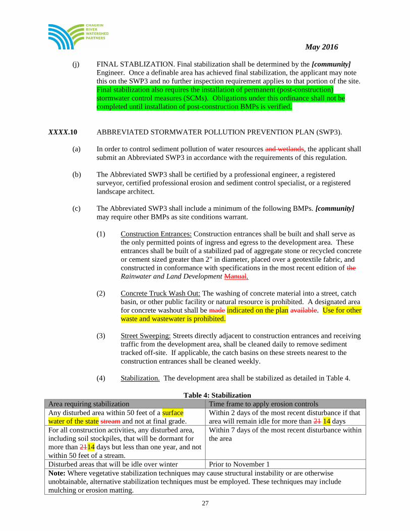
May 2016
27
(j) FINAL STABLIZATION. Final stabilization shall be determined by the [community]
Engineer. Once a definable area has achieved final stabilization, the applicant may note
this on the SWP3 and no further inspection requirement applies to that portion of the site.
Final stabilization also requires the installation of permanent (post-construction)
stormwater control measures (SCMs). Obligations under this ordinance shall not be
completed until installation of post-construction BMPs is verified.
XXXX.10 ABBREVIATED STORMWATER POLLUTION PREVENTION PLAN (SWP3).
(a) In order to control sediment pollution of water resources and wetlands, the applicant shall
submit an Abbreviated SWP3 in accordance with the requirements of this regulation.
(b) The Abbreviated SWP3 shall be certified by a professional engineer, a registered
surveyor, certified professional erosion and sediment control specialist, or a registered
landscape architect.
(c) The Abbreviated SWP3 shall include a minimum of the following BMPs. [community]
may require other BMPs as site conditions warrant.
(1) Construction Entrances: Construction entrances shall be built and shall serve as
the only permitted points of ingress and egress to the development area. These
entrances shall be built of a stabilized pad of aggregate stone or recycled concrete
or cement sized greater than 2" in diameter, placed over a geotextile fabric, and
constructed in conformance with specifications in the most recent edition of the
Rainwater and Land Development Manual.
(2) Concrete Truck Wash Out: The washing of concrete material into a street, catch
basin, or other public facility or natural resource is prohibited. A designated area
for concrete washout shall be made indicated on the plan available. Use for other
waste and wastewater is prohibited.
(3) Street Sweeping: Streets directly adjacent to construction entrances and receiving
traffic from the development area, shall be cleaned daily to remove sediment
tracked off-site. If applicable, the catch basins on these streets nearest to the
construction entrances shall be cleaned weekly.
(4) Stabilization. The development area shall be stabilized as detailed in Table 4.
Table 4: Stabilization
Area requiring stabilization Time frame to apply erosion controls
Any disturbed area within 50 feet of a surface
water of the state stream and not at final grade.
Within 2 days of the most recent disturbance if that
area will remain idle for more than 21 14 days
For all construction activities, any disturbed area,
including soil stockpiles, that will be dormant for
more than 2114 days but less than one year, and not
within 50 feet of a stream.
Within 7 days of the most recent disturbance within
the area
Disturbed areas that will be idle over winter Prior to November 1
Note: Where vegetative stabilization techniques may cause structural instability or are otherwise
unobtainable, alternative stabilization techniques must be employed. These techniques may include
mulching or erosion matting.

May 2016
28
(5) Inlet Protection. Erosion and sediment control practices, such as boxed inlet
protection, shall be installed to minimize sediment-laden water entering active
storm drain systems, including rear yard inlets. Straw, hay bales, and filter socks
or hay bales are not acceptable forms of inlet protection.
(6) Silt Fence and Other Perimeter Controls. Silt fence and other perimeter controls
approved by the [community] shall be used to protect adjacent properties and
water resources from sediment discharged via sheet (diffused) flow. Silt fence
shall be placed along level contours and the permissible drainage area is limited
to those indicated in Table 3 in XXXX.09 of these regulations.
(7) Internal Inspection and Maintenance. All controls on the development area shall
be inspected at least once every seven calendar days and within 24 hours after
any storm event greater than one-half inch of rain per 24 hour period.
Maintenance shall occur as detailed below:
A. When practices BMPs require repair or maintenance. If the internal
inspection reveals that a control practice BMP is in need of repair or
maintenance, with the exception of a sediment-settling pond, it must be
repaired or maintained within three (3) days of the inspection. Sediment
settling ponds must be repaired or maintained within ten (10) days of the
inspection.
B. When practices BMPs fail to provide their intended function. If the
internal inspection reveals that a control practice BMP fails to perform
its intended function and that another, more appropriate control practice
is required, the Abbreviated SWP3 must be amended and the new control
practice must be installed within ten (10) days of the inspection.
C. When practices BMPs depicted on the Abbreviated SWP3 are not
installed. If the internal inspection reveals that a control practice BMP
has not been implemented in accordance with the schedule, the control
practice must be implemented within ten (10) days from the date of the
inspection. If the inspection reveals that the planned control practice is
not needed, the record must contain a statement of explanation as to why
the control practice is not needed.
(8) Final Stabilization: Final stabilization shall be determined by the [community]
Engineer.
XXXX.11 FEES
The SWP3 Stormwater Pollution Prevention Plan and Abbreviated SWP3 Stormwater Pollution
Prevention Plan review, filing, and inspection fee is part of a complete submittal and is required to be
submitted to the [community] and the [county] SWCD before the review process begins. Please consult
with [community] Engineer for current fee schedule.
XXXX.12 BOND
(a) If a SWP3 Stormwater Pollution Prevention Plan or abbreviated SWP3 Stormwater
Pollution Prevention Plan is required by this regulation, soil disturbing activities shall not

May 2016
29
be permitted until a cash bond or deposit has been deposited with the [community]
Finance Department. The bond amount shall be a [$1,500] minimum, and an additional
[$1,500] paid for each subsequent acre or fraction thereof or the cost of stabilizing
disturbed areas based on a fee schedule established by the [community]. Note: Please
review and consult with Soil and Water Conservation District as applicable to ensure
bond or deposit amount is adequate. The bond will be used for the [community] to
perform the obligations otherwise to be performed by the owner of the development area
as stated in this regulation and to allow all work to be performed as needed in the event
that the applicant fails to comply with the provisions of this regulation. The cash bond
shall be returned, less [community] administrative fees as detailed in Chapter XXXX of
the [community] Codified Ordinances, after all work required by this regulation has been
completed and final stabilization has been reached, all as determined by the [community] Engineer.
(b) No project subject to this regulation shall commence without a SWP3 or Abbreviated
SWP3 approved by the [community] Engineer.
XXXX.13 ENFORCEMENT
(a) If the [community] or its duly authorized representative determines that a violation of the
rules adopted under this code exist, the [community] or representative may issue an
immediate stop work order if the violator failed to obtain any federal, state, or local permit
necessary for sediment and erosion control, earth movement, clearing, or cut and fill activity.
(b) All development areas may be subject to external inspections by [community engineer]
and/or the [county] SWCD to ensure compliance with the approved SWP3 or Abbreviated
SWP3.
(c) After each external inspection, [community engineer] and/or the [county] SWCD shall
prepare and distribute a status report to the applicant.
(d) If an external inspection determines that operations are being conducted in violation of the
approved SWP3 or Abbreviated SWP3 [community engineer] and/or the [county] SWCD
may take action as detailed in Section XXXX.14 of this regulation.
(e) Failure to maintain and repair erosion and sediment controls per the approved SWP3 plan
may result in the following escalation:
i. First Violation: The [community engineer] will issue a Notice of Deficiency to the
owner or operator. All controls are to be repaired or maintained per the SWP3 plan
within three (3) days of the notification. If controls have not been corrected after this
time, the [community engineer] may issue a Stop Work Order for all activities until
corrections have been made.
ii. Second Violation: The [community engineer] may issue a formal Notice of Violation
which includes a $250 administrative fee against the SWP3 Bond or site plan deposit.
All controls are to be repaired or maintained per the approved SWP3 plan within
three (3) days of the Notice of Violation. If controls have not been corrected after
this time, the [community engineer] may issue a Stop Work Order for all activities
until corrections have been made.

May 2016
30
iii. Third and subsequent violations: The [community engineer] may issue a Stop Work
Order for all construction activities and charge a $250 administrative fee against the
SWP3 bond or site plan deposit. The Stop Work Order will be lifted once all controls
are in compliance with the approved SWP3 plan.
(f) The [community engineer] shall have the authority to make immediate on-site adjustments to
the SWP3 in order to achieve compliance with this ordinance.
(g) A final inspection will be made to determine if the criteria of this code has been satisfied and
a report will be presented to the [Community] on the site's compliance status.
(h) The [community engineer] will monitor soil-disturbing activities for non-farm residential,
commercial, industrial, or other non-farm purposes on land of less than one contiguous acre
to ensure compliance required by these Rules.
(i) The [community engineer] shall notify the U.S. Army Corps of Engineers when a violation
on a development project covered by an Individual or Nationwide Permit is identified. The
[community engineer] shall notify the Ohio Environmental Protection Agency when a
violation on a development project covered by a Section 401 Water Quality Certification
and/or Isolated Wetland Permit is identified.
(j) The [Community] shall not issue building permits for projects regulated under this code that
have not received approval for an SWP3 for said project(s).
XXXX.14 VIOLATIONS
(a) No person shall violate or cause or knowingly permit to be violated any of the provisions
of this regulation, or fail to comply with any of such provisions or with any lawful
requirements of any public authority made pursuant to this regulation, or knowingly use
or cause or permit the use of any lands in violation of this regulation or in violation of
any permit granted under this regulation.
(b) Upon notice, the Mayor and/or designee [assign authority as consistent with City
chapter] may suspend any active soil disturbing activity for a period not to exceed ninety
(90) days, and may require immediate erosion and sediment control measures whenever
he or she determines that such activity is not meeting the intent of this regulation. Such
notice shall be in writing, shall be given to the applicant, and shall state the conditions
under which work may be resumed. In instances, however, where the Mayor and/or
designee finds that immediate action is necessary for public safety or the public interest,
he or she may require that work be stopped upon verbal order pending issuance of the
written notice.
XXXX.15 APPEALS
Any person aggrieved by any order, requirement, determination, or any other action or inaction by the
[community] in relation to this regulation may appeal to the court of common pleas. Such an appeal shall
be made in conformity with [insert appropriate Ohio Revised Code sections]. Written notice of appeal
shall be served on the [community] and a copy shall be provided to the [county] SWCD.
XXXX.99 PENALTY
(a) Any person, firm, entity or corporation; including but not limited to, the owner of the

May 2016
31
property, his agents and assigns, occupant, property manager, and any contractor or
subcontractor who violates or fails to comply with any provision of this regulation is
guilty of a misdemeanor of the third degree and shall be fined no more than five hundred
dollars ($500.00) or imprisoned for no more than sixty (60) days, or both, for each
offense. A separate offense shall be deemed committed each day during or on which a
violation or noncompliance occurs or continues.
(b) The imposition of any other penalties provided herein shall not preclude the [community]
instituting an appropriate action or proceeding in a Court of proper jurisdiction to prevent
an unlawful development, or to restrain, correct, or abate a violation, or to require
compliance with the provisions of this regulation or other applicable laws, ordinances,
rules, or regulations, or the orders of the [community].