Embed Size (px)
Citation preview

Michigan Transportation Asset Management Council
&Center for Shared Solutions
Rog Belknap, TAMC CoordinatorMark Holmes, DTMBDave Jennett, CSSMelissa Carswell, MDOT
Roadsoft Users Conference of the US 2016

RUCUS Outline
Transportation Asset Management Council• Brief Overview of TAMC• Roles & Responsibilities• Data Collection – Management Cycle
Department of Technology Management & Budget• Overview of the Michigan Geographic Framework • Future technology updates for GIS data management
Center for Shared Solutions• Interaction between Roadsoft and Investment Reporting Tool (IRT) • Overview of IRT application re-write by CSS for 2017
Department of Transportation• Traffic Data Management• Update

Michigan – A Home Rule State
Michigan’s Road System
617 Agencies with Road Ownership• 83 Counties
• 533 Cities and Villages
• MDOT
Partners in Management• 1,240 Townships
• 14 Planning Regions
• 15 Metro Planning Agencies
• Consultants & Contractors

All public roads in Michigan will be managed using the principles of Asset Management
– Michigan Legislature
Public Act 499 of 2002
• Act Creates Transportation Asset Management Council – TAMC
• Advisory to State Transportation Commission Asset Management Process Tools and Education Statewide Asset Management Strategy Federal Aid System First
• Partnership for Deployment with Metro & Regional Planning Agencies
• Reporting of Conditions & Investments
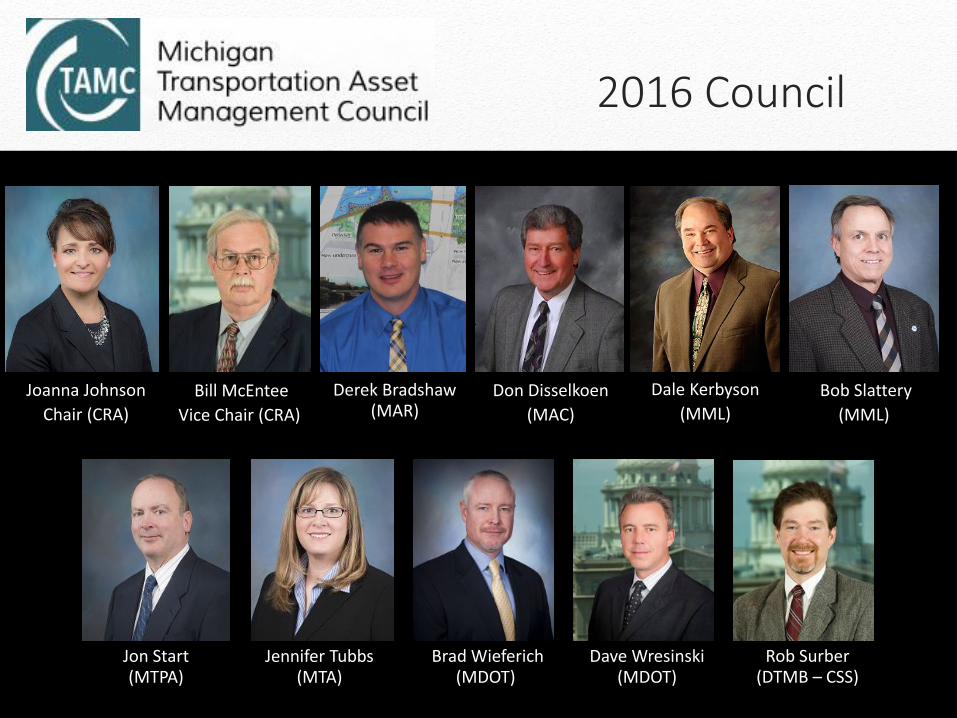
Jon Start (MTPA)
Derek Bradshaw (MAR)
Brad Wieferich (MDOT)
Rob Surber (DTMB – CSS)
Jennifer Tubbs (MTA)
Don Disselkoen
(MAC)
Joanna Johnson
Chair (CRA)
Bob Slattery
(MML)
Dale Kerbyson
(MML)Bill McEntee
Vice Chair (CRA)
Dave Wresinski (MDOT)
2016 Council

Support & Partners
Dave Jennett (DTMB – CSS)
TAMC Support Division, Bureau of Transportation Planning (MDOT)
Tim Colling, PhD. P.E. (MTU - CTT)

Workshops, Conferences and Trainings
PASER Data Collection
• +/- 163,000 lane miles of Federal Aid
• +/- 33,740 lane miles of Non-federal Aid Paved roads rated
Continued Publication of Michigan’s Roads & Bridges Annual Report
Recognition of Achievement through Carmine Palombo Award & TAMC Organizational Award
Dashboards & Interactive Maps
Deliverables
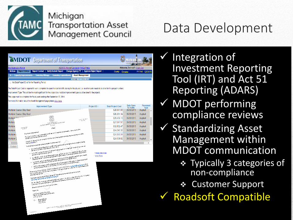
Integration of Investment Reporting Tool (IRT) and Act 51 Reporting (ADARS)
MDOT performing compliance reviews
Standardizing Asset Management within MDOT communication Typically 3 categories of
non-compliance Customer Support
Roadsoft Compatible
Data Development

Data Management Cycle

Web page
Map Service
Access to hourly and AADT data
New Software- TDMS
Traffic Data Management

Office of Technology PartnershipsGIS CollaborationMichigan Geographic Framework (MGF)
Technology Upgrade Project

MGF Background
12
• MGF began in the 1990s
– Produced 16 annual versions to date
– Framework modeled after national Framework concepts
– Modeled using Census Tiger topological model
– Initially used ArcInfo Coverage Data Format
– Integrated boundary geography, roads, hydrology, rail
– Integrated Linear Referencing System for all roads
– Annual versions are made publicly available
– Seen by federal agencies and other states as a model integrated state framework

Components of Today’s MGF
13
• Local• MDOT
• MDOS• CSS
StandardsBusiness
Rules
PermissionsData
MGFEE
Michigan Geographic Framework Editing Environment (MGFEE)

Reasons for change
14
• MGFEE system is end of life– Older programming technology– No longer being supported through new version releases– Delivery generation tools use old technology and data formats
• Newer technology to improve data management• Develop new federated model using distributed architecture• Data stewards use their own editing tools to manage their
authoritative data then provide changes back to MGF master GIS repository – State Spatial Data Infrastructure model– MDOT implementing ESRI Roads and Highways– State agencies use their own editing software
• Leverage services to provide access to MGF data more frequently

New Technology
15
MGFMDOT Local
CSS
DNR

MGF Federated System

What to expect
• Version 17 to be delivered in current MGF format
• Version 18 will be a transitional delivery, LRS will be produced from ESRI Roads and Highways
• Anticipate some changes to current deliverables– No .e00 export
– Files as shapefiles or feature classes
– Some fields that are no longer used may be removed
• Migration table is planned to be produced from ESRI Roads and Highways
• More outreach and communication as project begins
• Survey in progress

Today and Tomorrow
MGF Today MGF Next
One editing environment Distributed editing
Annual versions More frequent versions
Cannot load bulk features Can integrate bulk uploads
Data products are produced as exported files
Service oriented architecture – connect to a service to get updates
Highly customized More COTS than customized (expected)
MGF data layers publicly available Geospatial repository to manage publication version of data based on data classification, open and internal

Center for Shared Solutions
Interaction Between Roadsoft &
Investment Reporting Tool (IRT)
Overview of IRT Application
Re-write by CSS for 2017

Both the IRT and Roadsoft are free to local agencies.
IRT can have multiple users and is a website where Roadsoft is
software loaded on a single computer.
Jurisdictions can use either tool for managing their investment
data. The IRT is suited directly for investment reporting
whereas Roadsoft offers more advanced features and
additional tools.
REMINDER: Roadsoft Users must still use portions of the IRT
to meet their reporting requirements. (Specifically they must
upload or export their investment data to the IRT so it can sync
to ADARS and update their annual reporting Status to being
complete.)
Roadsoft and the IRT (Investment Reporting Tool)

Website - www.michigan.gov/tamc

IRT (CSS)
• TAMC
Statewide
Database
ADARS/ACT51 (MDOT)
• Verify PROJECTS
pulled from IRT
• Enter Project Costs
• Requires Total Costs
for Each Project (Not
annual cost)
Overview of Investment Reporting ProcessPROJECT ID / PROJECT NAME
• Unique for each project
• Common ground - links all systems.
• Can be street names or ID numbers
IRT (CSS)
• Enter PROJECTS
ROADSOFT (CTT)
• Enter PROJECTS
• PASER Ratings
PROJECTS
• “The what, the where and the when”• Current year Road & Bridge work
• 3yr Plan - Planned Projects

Investment Reporting Tool (IRT)
Data
Road Data
Bridge Data
Send / Get Data
HPMS Data
Map
Enter Road & Bridge data
View Road (TAMC) data
Reports
Road and Bridge projects
Includes ADARS Report
that matches Asset
Management page in
ADARS
Status
Indicate TAMC compliance
Review summary

IRT Training Page - Resources
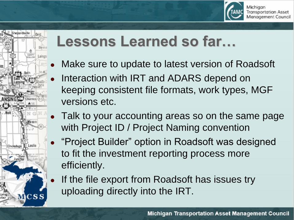
Lessons Learned so far…
Make sure to update to latest version of Roadsoft
Interaction with IRT and ADARS depend on
keeping consistent file formats, work types, MGF
versions etc.
Talk to your accounting areas so on the same page
with Project ID / Project Naming convention
“Project Builder” option in Roadsoft was designed
to fit the investment reporting process more
efficiently.
If the file export from Roadsoft has issues try
uploading directly into the IRT.

IRT Data Page / Send (Upload File)

IRT Data Page / Send / Roadsoft

IRT Data Page / Send / Roadsoft

IRT Data Page / Get (File Library)

Known issues… Files not uploaded properly or timed out –
sometimes due to outdated Roadsoft version
Problems with matching treatment types
No Custom treatments allowed
Misleading confirmation emails – PASER file
was uploaded but no feedback to what the file
contained – problem with local PASER data last
year.
…..The good news…..
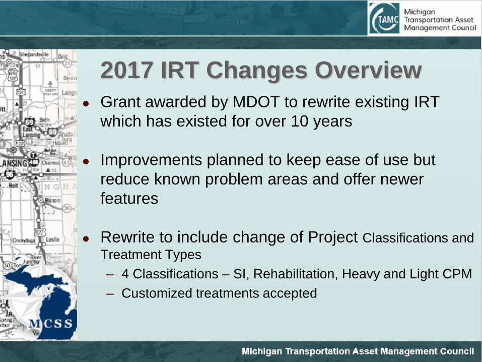
2017 IRT Changes Overview
Grant awarded by MDOT to rewrite existing IRT
which has existed for over 10 years
Improvements planned to keep ease of use but
reduce known problem areas and offer newer
features
Rewrite to include change of Project Classifications and
Treatment Types
– 4 Classifications – SI, Rehabilitation, Heavy and Light CPM
– Customized treatments accepted

Direction of the New IRT:

IRT Changes Overview (cont.)
Ability to upload Asset Management Plans
Provide feedback to TAMC on agencies
investment planning processes
Better means to manage past data sets
Work flow to identify action items
Mass deletes for previous planned data
Validation and feedback on PASER file upload

Preview of New PASER Upload

Questions
Feedback
Requests

Contacts & Resources
Rog Belknap [email protected]
Melissa Carswell [email protected]
Mark Holmes [email protected]
Dave Jennett [email protected]
TAMC IRT Helpdesk/ CSS (Center for Shared Solutions)
– [email protected] (517) 373-7910
Resources also can be found under Training and
Support on the TAMC website: www.michigan.gov/tamc
Thank You