Embed Size (px)
Citation preview

Marine Spatial Planning ToolkitIvica Trumbić, Chief Technical Advisor, GEF LME:LEARN
Zagreb, 9-10 April 2019
MSP as a tool for the implementation of ICZM Protocol in the Mediterranean
GEF LME:LEARN
Planification SpatialeMaritime Transfrontalière
Module 3
Initiation de la PSM
Alejandro Iglesias-CamposCOI-UNESCO
marine.iwlearn.net

GEF LME:LEARNGlobal home for LME-MPA-ICM
supporting activities
Improve global ecosystem based governance of LMEs and their coasts
Generating knowledge
Building capacity
Public and private partnerships
South-south/north-south learning
Implementation period: 2016-2020

What are LME’s ?
Large areas of
ocean space
US$ 3 trillion annually
Unique physiography
Biodiversity,ecosystem
services and tangible benefits
Transboundary

LME Pressures and Risks
Nutrient Over-
Enrichment and
Hypoxia
Marine Pollution/
Debris
Unsustainable
Fishing Practices
Invasive Species
Ocean Acidification
Cumulative Human Impact

The LME Modular Approach
Productivity
Pollution & Ecosystem
Health
Fish & Fisheries
Governance
Socioeconomics

Partners

GEF LME:LEARN Components
1. Global and regional network of partners
2. Synthesis and incorporation of knowledge
3. Capacity and partnership building
4. Communication, dissemination and outreach
iwlearn.net/marine

COMPONENT 2: SYNTHESIS AND INCORPORATION OF KNOWLEDGE
8
• LME:LEARN objective: generate harmonized knowledge product
• harmonized set of tools
• seven toolkits
• existing science
• harvesting experiences and best practices
• other non-GEF marine and coastal initiatives

MARINE TOOLKITS BROCHURE
24-May-19 9

WHAT ARE MARINE TOOLKITS?
• assist GEF funded and other projectsworking in marine related focal areas
• address emerging priorities and newrequirements
• promote innovative approaches
• hundreds of tools
• numerous references, available online
24-May-19 10

https://iwlearn.net/manuals

CHARACTERISTICS OF MSP
• Ecosystem-based
• Integrated
• Place-based or area-based
• “Soft space” planning
• Adaptive
• Strategic and anticipatory
• Participatory


BOUNDARIES PERTAINING TO THE DELINEATION OF COASTAL AREAS: THE PHYSICAL, ADMINISTRATIVE AND LEGAL
CONTEXTS
Mean high tide
GEO
PH
YS
IC
AL
BO
UN
DA
RIES
Inla
nd
s o
rn
on
-co
asta
l
Coastal Uplands ShorelandsContinental shelf
Continental margin
Continentalslope
Plainrise
Abyssalplain
Mean low tide
DE F
AC
TO
C
ON
TR
OL
Weak Control by Government of Coast Nation
Inter-nationalcontrol
Extensivegovernment
control
Predominant privatesector control
Predominantgovernment
control
PR
OP
ER
TY
R
IG
HTS
Private/Public Private/Public Public Public/commonInter-national
PLA
NN
IN
G
MA
NA
GEM
EN
T
LEV
ELS Regional
Inter-national
NationalLocal Community District/Municipality
Province/StateNational

TRANSBOUNDARY MSP
• typical for Large Marine Ecosystems• delineating boundaries is fundamental• delineation most often defined by political
and jurisdictional borders• MSP is normally conducted by national or sub-
national authorities• borders do not always correspond to the
limits of ecosystems• ecosystem-based approach• majority of 66 LMEs span across national
jurisdictional boundaries• LME boundaries do not always correspond to
the given jurisdictional boundaries

CROSS BORDER MSP
• cross-border MSP - engagement between two or more entities that share a common political border (e.g. neighbouring countries).
• disputes on the exact locations of these borders.

TRANSBOUNDARY MSP
• transboundary MSP - engagement of multiple entities(e.g. countries, states, provinces) across one ecosystem, who also do not necessarily share a common border
• expands beyond transnationalencompasses sub-nationaland the high seas
• each entity has individual jurisdiction over differentocean spaces, different economic considerations, driversfor MSP, etc.
• sub-national, multi-national
• level of complexity increases

MSP TOOLKIT
24-May-19 18

WHAT IS THE MSP TOOLKIT?
• practical guidance with examples of tools and methods
• existing LME MSP experiences as well as other transnational MSP practices
• promotes an integrated, collaborative approach to coastal and ocean management
• training:
iwlearn.net/learning/courses

STRUCTURE OF THE MSP TOOLKIT
general components of an MSP process
highlights specific aspects for a transboundary MSP process
examples of relevant tools and approaches

TARGET AUDIENCE
• those who will initiate an MSP process in the LME context
• those who are already involved in transboundary MSP
• those that need guidance initiating the very first transboundary MSP process within a given LME

CONTENTS OF THE MSP TOOLKIT
• Introduction to Transboundary Marine Spatial Planning
• Designing the Transboundary MSP Process
• Stakeholder Engagement in Transboundary MSP
• Analysing the Current Conditions
• Analysing future conditions & developing joint visions
• Solutions, Planning and Implementation
• Monitoring & Evaluation of Transboundary MSP

HOW SHOULD YOU USE THE TOOLKIT?
• interactive online and downloadable PDF resource
• available on the Marine Toolkit Portal, whichcan be found at www.iwlearn.net/manuals
• self-standing document• each section of the toolkit describes a
distinct method• users can move sequentially through the
toolkit or go directly to the sections that are relevant to their needs
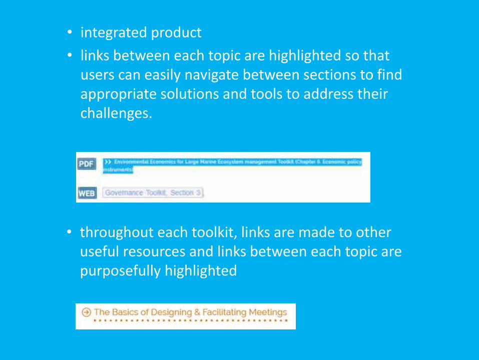
• integrated product
• links between each topic are highlighted so thatusers can easily navigate between sections to findappropriate solutions and tools to address theirchallenges.
• throughout each toolkit, links are made to otheruseful resources and links between each topic are purposefully highlighted
The Marine Toolkits have been developed as both an interactive online and
downloadable PDF resource. The online products are available on the Marine Toolkit
Platform, which can be found at www.iwlearn.net/manuals.
These Marine Toolkits cover a wide range of themes that of interest to LME and other
marine managers. Each Toolkit is also a self-standing document, which covers its topic
at the level of detail needed by its target audience. However, each section of the Toolkit
describes a distinct method that is potentially relevant to management of
LME/MPA/ICM/MSP/climate change adaptation. Users can move sequentially through
each Toolkit or go directly to the sections that are relevant to their needs.
The Toolkits were developed to be an integrated product. Links between each topic are
purposefully highlighted so that users can easily navigate between sections to find
appropriate solutions and tools to address their challenges.
HOW SHOULD YOU USE THE MARINE
TOOLKITS AND PLATFORM?
Throughout each Toolkit, links are also made to other useful resources. Every Toolkit
can and should be used alongside these other resources.
Finally, each Toolkit contains an extensive “List of References”. Most of the references
are already uploaded in the GEF IW: LEARN repository of Documents, and each
available reference in the List can be opened by clicking on it.
WEB

Governance
Project
Stakeholders
Strategic
Economic
Scorecard
USING OTHER TOOLKITS IN MSP
TOOLKIT
Thank youIvica Trumbić
GEF LME:LEARN
Planification SpatialeMaritime Transfrontalière
Module 3
Initiation de la PSM
Alejandro Iglesias-CamposCOI-UNESCO
marine.iwlearn.net