Embed Size (px)
Citation preview

Magnetic Island TrailsDRAFT VISION PLAN

A joint initiative of Townsville City Council and Queensland Parks and Wildlife Service.
ContentsContext
Introduction
Vision and purpose
Principles
Philosophy
1.1
1.2
1.3
1.4
Existing infrastructure
Pathways and bush walking tracks entrances/exits
Walkers versus cyclists and vehicle interactions
Island vistas
2.1
2.2
2.3
2.4
Picnic Bay - Blue Section
Nelly Bay - Magenta Section
Arcadia - Red Section
Forts and Florence Bay - Yellow Section
Horseshoe Bay - Green Section
3.1
3.2
3.3
3.4
3.5
Activation zones
Tenure
4.1 Responsibility
1. 3.
2. 4.The current situation
3 | | 2

1. Context 1.1 Introduction
Magnetic Island gets its name from the supposed ‘magnetic’ effect it had on Captain Cook’s ship’s compass as he sailed Australia’s east coast in 1770. However, despite extensive exploration and experimentation, the only magnetic effect discovered on the island is the one that it has on tourists.
Magnetic Island is located in Cleveland Bay, just eight km from Townsville on the Queensland coast, only a short 20 minute ferry ride from Townsville to Nelly Bay. The rocky granite headlands fuse with sheltered bays and its 23 beaches, which create a dramatic and spectacular coastline. Over seventy-five percent of the island is now classified as National Park, providing a haven for the island’s native wildlife.
The Aboriginal Traditional Owners of Yunbenun (Magnetic Island), the Wulgurukaba (canoe people), have lived on the island and nearby mainland for thousands of years. Shell middens, stone tools and art sites are some of the physical reminders of their strong connection with the island. The Wulgurukaba have stories, such as the Gabul story, linking Magnetic and Palm Islands and the mainland, which tell of the creation of this landscape during the Dreamtime.
There are a number of outdoor activities on Magnetic Island including bush walking, birdwatching, boat trips, parasailing, snorkeling tours, bus tours, water sports, golf, diving expeditions, jet skiing, great fishing and horse riding. The Magnetic Island Forts Complex is the number one tourist attraction on the island. Upgraded in 2013/14, current visitor numbers to the Forts Complex are in excess of 100,000 per annum.
Both the Queensland Parks and Wildlife Service (QPWS) and Townsville City Council (TCC) manage a number of established pathways and bush walking tracks on the island. However, they are not well linked; especially where they cross tenures as the different agencies tend to treat them as individual pathways and bush walking tracks rather than part of a larger network. Visitors often have trouble finding the bush walking tracks and often do not know where they exit. There are also several ‘missing links’ across the island that make the trail network hard to navigate, and in some places unsafe, where walkers are often forced to walk on the road.
The trails network is a major method of transport on the island for visitors and locals and stakeholder feedback has identified pathways and bush walking tracks as an important part of the Magnetic Island experience.
Koalas on Magnetic Island.
Photo: Queensland Government
The Forts walk is one of the most popular on the island.
Photo: Queensland Government
5 | | 4

1.2 Vision and purpose
A high-quality trail network connecting Magnetic Island’s attractions, enhancingvisitor experience and increasing tourism opportunities for the island.
This project is a joint planning initiative between TCC and QPWS with the aim to complete an interconnected trails network across Magnetic Island for the benefit of the local community, visitors to the island, and local and regional tourism as a whole.
This collaboration will benefit from a coordinated approach to the development of a fully interconnected trail network throughout the island that crosses tenures to link the island’s destinations, hubs and attractions.
The following vision plan identifies existing pathways and bush walking tracks, as well as vital missing links in the existing trails network. Guiding principles encompass the key elements, that when combined together drive the overall direction of the project.
Purpose The intent of the vision plan is to:
• take a holistic view of the island and identify pathway and bush walking track connections linking the island’s major destinations, hubs and attractions;
• identify the missing links between TCC and QPWS’ existing pathways and bush walking tracks;• identify potential new links that will improve the connectivity of the trails network;• create a blueprint that provides a longer-term vision for the trails network, that will guide future investment and
allow TCC and QPWS to engage with stakeholders and seek funding from a range of potential sources.
Vision
Alma Bay
Geo�rey Bay
Rocky Bay
Hawkings PointNobby Head
Bright Point
Bremner Point
The Point
Orchard Rocks
White Rock
Whit�eld Cove
Cockle Bay
Arthur Bay
Florence Bay
GowrieBay
Radical Bay
Balding Bay
Lovers Bay
Horseshoe Bay
Maud BayNorris Bay
Joyce Bay
WilsonBay
Hunting�eldBay
RollingstoneBay
YoungBay
BolgerBay
Mt Cook 493m
Magnetic IslandNational Park
Proposed TrackUnsealed RoadWalking TrackLookoutNational ParkMarine Park - NO FishingReefShipwreck SitePipeline Service Corridor
N
kilometres
0 1 2 3
Picnic Bay
Nelly Bay
Arcadia
Horseshoe Bay
West Point
The Forts
Arthur Bay
Florence Bay
Florence Bay7 | | 6

1.3 Principles
Function and Purpose• Physical connection—connected pathways and bush
walking tracks linking the island’s main destinations and attractions.
• Visual interaction—wayfinding, signage and branding.
• Safety – provide a safe experience for users of the trails network.
• Easy to navigate.• Connected to transport, buses, ferries.• Connecting local businesses.
Scenic Amenity• Multi-sensory experiences— suburbia, national park,
secluded beaches, panoramic views.
Quality Outcomes• High quality facilities—rest stations, weather
shelters, waste options, pathways and tracks and signage that complement the environment and fit into their location.
• Fit for purpose — reducing future maintenance requirements. Upgrading existing key links.
Activation of Space• Access to natural assets—national park, range of
different landforms, secluded beaches.• Increased tourist and recreational opportunities on
the island.
Cultural and Natural Values• Recognition of environmental and historical values—
flora and fauna, Great Barrier Reef Marine Park, wartime relics.
• Indigenous values.
Relationships• Commercial inclusion—Tourist destination outcomes
local/ regional residential / community ownership.• Human and environmental interactions.• QPWS/TCC.• Traditional Owners.• Stakeholders.
Signage Branding• Clear, concise and consistent—iconic to Magnetic
Island.• Seamless experience – but still adheres to agencies’
brand guidelines. • North Queensland experience.
1.4 PhilosophyThe Magnetic Island Trails Vision Plan will continue to expand with the development of the island’s pathways and bush walking tracks contained within the trails network. Site-specific obstacles, as well as solutions are expected to materialise through the development of detailed plans for individual sections and missing linkages. It is understood and expected that treatments will be appropriate for the location and section type, for example pathways in built up areas, and bush walking tracks in the national park. Some links will require new pathways and bush walking tracks to be built, whilst other links may be lower key and simply require wayfinding signage.
Hawkings Point bush walking track upgrade Nelly Bay to XBase Backpackers multiuse pathway Henry Lawson all-tide access bush walking track
Further site investigation and concept planning is required.
Signs and information should cross tenures to give the walkers a seamless experience but still adhere to all agency brand guidelines. Wayfinding signage should create an easy and seamless experience for locals, visitors and tourists engaging with the trails network and accessing the island’s attractions. This will ensure the development of easy navigation to link hubs, containing destination information points which provide a glimpse of the island’s secrets and encourage interaction and activation.
The Magnetic Island Trails Vision Plan focuses on the first steps to achieve this vision and is fully expected to develop further over time. It is important to understand that other opportunities are possible and that some existing pathways and bush walking tracks will need upgrades over time to support the vision. Additionally, whilst they have been primarily noted as bush walking tracks, there is the opportunity to accommodate a range of users. This will be explored and understood in further detail when developing concept plans for individual sections.
For information and orientation purposes, some local businesses, services, key locations and attractions have been identified on maps. It should be noted and understood that they are not a catalogue or representation of every activity, destination or opportunity available on the island.
Recent works completed on the island that contribute to this plan include the following:
Arthur Bay access bush walking track
Nelly Bay walkway
The Forts
Hawkings Point Trail 9 | | 8

2. The current situation 2.1 Existing infrastructure
Existing track types vary greatly including high quality pathways in built-up and high visitation areas, formal Class 3 and 4 bush walking tracks in the national park, and informal ’goat tracks’ to lesser known destinations.
Gabul Way (Marine Parade)
Lagoon Walk Horseshoe Bay
Hawkings Point Track Nelly Bay Road
Nelly Bay Trail Head
Hawkings Point Track Hawkings Point Track
Gabul Way (Magnetic Island Road)
Boat Ramp Nelly Bay
Hawkings Point Track Hawkings Point Track11 | | 10

2.2 Pathways and bush walking tracks entrances/exits
In most cases entrance and exit points are located at the end of residential roads with limited signage or distinguishing wayfinding cues. Walkers are required to wander along back streets to locate trailheads. Key pathway links are missing.
2.3 Walkers versus cyclist and vehicle interactions
Many of the pathways and bush walking tracks are not physically connected. Disconnection points generally exist on the crests of hills in extremely dangerous locations or between existing pathways in the built-up areas and the entrances of bush walking tracks.In most circumstances, walkers are required to step into the traffic lanes of busy roads or cross the roads on blind corners or near the crest of a hill offering limited vision and an unsafe outcome.Nelly Bay Road (Picnic Bay) Gabul Way (Magnetic Island Road)
Nelly Bay Trail Head Telstra Track Horseshoe Bay RoadHawkings Point Track Picnic Bay
Nelly Bay Trail Head Forts Junction Horseshoe Bay RoadNelly Bay Road
Forts Junction - Horseshoe Bay Road Birt Street - Picnic BayNelly Bay Road - Picnic Bay
Forts Junction - Radical Bay Road Forts Junction - Horseshoe Bay RoadNell Bay Road - Picnic Bay
Forts Junction - Horseshoe Bay Road Magnetic Island Street - Picnic Bay
13 | | 12

2.4 Island vistas
Magnetic Island’s ridgelines, look-outs and secluded beaches are bound by magnificent ocean views and well vegetated national parks. The island trails network engages with and traverses through patches of tropical rainforest and native vegetation containing numerous tranquil crystal clear creeks and large boulder-size rock formations.The visual and physical experience is world class.
3. Activation zones
Hawkings Point Lookout
Horseshoe Bay
Hawkings Point Lookout
Hawkings Point Lookout Hawkings Point Lookout
Hawkings Point Lookout
15 | | 14
3.1 Picnic Bay
Picnic Bay features an open-air shopping complex, the Picnic Bay Mall, and a patrolled beach along the waterfront. The bay also hosts the Magnetic Island Golf Course and the Magnetic Island Police Station. Off the coast, the wreck of the George Rennie is visible at low tide.
Existing pathways and bush walking tracks are disconnected from each other and the main tourist destinations in the bay. The only land based access from Nelly Bay is over a large hill via the Nelly Bay Road and Birt Street connection road.
Walkers are currently required to share the steep inclines and declines, with cyclists, scooters, cars and buses all navigating the narrow winding roads.
Picnic Bay Golf Club provides a unique golfing experience on a tropical island. This section connects to the existing pathway and will provide physical connection from bus stops to the Golf Course Club House.
B1
This will link the ’hub’ of Picnic Bay esplanade with the Hawkings Point Lookout—a popular National Park attraction is on the top of a large boulder, affording a spectacular panoramic view over the island past Rocky Bay to Nelly Bay and Geoffrey Bay and back towards Townsville’s mainland.
B2
There is currently no continuous pathway linking Nelly Bay over the hill to Picnic Bay. This section will complement recent works in Nelly Bay to provide a safe, high-quality pathway to the Picnic Bay Esplanade.
B3This will formalise existing goat tracks to Rocky Bay—a secluded beach popular with tourists and locals. It will also link with the Hawkings Point lookout bush walking track to provide a range of different loop options in the Picnic Bay area.
B4/B5
Picnic Bay Golf Course
Hawkings Point Lookout
Picnic Bay Esplanade
Backpacker Resort
Nelly Bay Ferry Terminal
Supermarket Shops
Commercial Centre & School
Hire Companies
Supermarket Shops
Nelly to Arcadia Track
Arcadia Village
Nelly toArcadia Track
Sphinx Lookout
Alma Bay Beach
Forts Junction
Horseshoe Bay Connection
Arthur Bay
Forts Track
Lookout
Tower Track
Florence Bay Beach
Forts Complex
Horseshoe Bay Ranch
Skate Park
Bungalow BayKoala Village
Horseshoe Bay EspHorseshoe Bay Beach
Radical Bay Beach
Balding Bay Beach
Endevour Creek
Nelly to Arcadia Track
Lagoon
Cockle Bay Reef
Orchard Rocks
Geoffrey Bay
NellyBay
Horseshoe Bay
FlorenceBay
GowrieBay
ArthurBay
Five Beach Bay
Rollingstone Bay
Young Bay
Bolger Bay
HuntingfieldBay Wilson Bay
Joyce Bay
Norris Bay
Maud Bay
Lovers Bay
White Rock
NobbyHead
Cockle Bay
HawkingsPoint
Rocky Bay
BrightPoint
BremnerPoint
WhitfieldCove
The Point
Magnetic IslandNational Park
West Point
Liver Point
Mt Cook493m
RetreatCreek
DuckCreek
Ned LeeCreek
ButlerCreek
GustavCreek
PetersenCreek
White LadyBay
GorgeCreek
George Rennie Wreck
G4
G2
G1
G3
Y2
Y3
Y1
Y4
R4
R3
R1
R2
M1
M2
B1
B2
B4
B3
B5
R5
R6
Y5
G5
Tourist destinations
Existing pathways
Proposed pathways and bush walking tracks
QPWS bush walking tracks
Bus stops
Telstra track
Tourist destinations
Existing pathways
Proposed pathways and bush walking tracks
QPWS bush walking tracks
Bus stops
Pipeline Service Corridor (very steep)
Tourist destinations
Existing pathways
Proposed pathways and bush walking tracks
QPWS bush walking tracks
Bus stops
N
Forts and Florence Bay
Arcadia
Picnic Bay
Horseshoe Bay
Nelly Bay
17 | | 16

3.2 Nelly Bay
The access point for tourists and residents arriving by ferry or barge, Nelly Bay is the transport hub of the island. It is the central drop-off and pick-up location for bus routes on the island and also accommodates a range of commercial hire companies.
Set in this tropical oasis, the Magnetic Island School accommodates between 130 and 150 students annually. Prominent food outlets and tourist-based providers define a central shopping destination for visitors and locals.
Linking the townships of Nelly Bay and Arcadia through the National Park with the Forts Junction, the Nelly to Arcadia bush walking track is a key part of the overall Magnetic Island trail network.
The bush walking track passes though a cool patch of rainforest alongside Gustav Creek and then climbs gradually to the saddle between Nelly Bay and Horseshoe Bay before following a ridge running along the middle of the island, taking in stunning views looking over Horseshoe Bay and out to the Palm Islands.
Currently the Nelly to Arcadia bush walking track is not linked to the ferry terminal at Nelly Bay and walkers must follow intermittent signs along Mandalay Avenue. M1 will provide a formal connection to the trailhead to guide users to and from the Nelly Bay transport hub.
As the main access point to the island, the establishment of a major trailhead at the terminal will provide directions and information about the island’s trails network and tourist attractions.
M1
M2 will formalise a short link past the boat ramp along the Nelly Bay breakwater.M2
Picnic Bay Golf Course
Hawkings Point Lookout
Picnic Bay Esplanade
Backpacker Resort
Nelly Bay Ferry Terminal
Supermarket Shops
Commercial Centre & School
Hire Companies
Supermarket Shops
Nelly to Arcadia Track
Arcadia Village
Nelly toArcadia Track
Sphinx Lookout
Alma Bay Beach
Forts Junction
Horseshoe Bay Connection
Arthur Bay
Forts Track
Lookout
Tower Track
Florence Bay Beach
Forts Complex
Horseshoe Bay Ranch
Skate Park
Bungalow BayKoala Village
Horseshoe Bay EspHorseshoe Bay Beach
Radical Bay Beach
Balding Bay Beach
Endevour Creek
Nelly to Arcadia Track
Lagoon
Cockle Bay Reef
Orchard Rocks
Geoffrey Bay
NellyBay
Horseshoe Bay
FlorenceBay
GowrieBay
ArthurBay
Five Beach Bay
Rollingstone Bay
Young Bay
Bolger Bay
HuntingfieldBay Wilson Bay
Joyce Bay
Norris Bay
Maud Bay
Lovers Bay
White Rock
NobbyHead
Cockle Bay
HawkingsPoint
Rocky Bay
BrightPoint
BremnerPoint
WhitfieldCove
The Point
Magnetic IslandNational Park
West Point
Liver Point
Mt Cook493m
RetreatCreek
DuckCreek
Ned LeeCreek
ButlerCreek
GustavCreek
PetersenCreek
White LadyBay
GorgeCreek
George Rennie Wreck
G4
G2
G1
G3
Y2
Y3
Y1
Y4
R4
R3
R1
R2
M1
M2
B1
B2
B4
B3
B5
R5
R6
Y5
G5
Tourist destinations
Existing pathways
Proposed pathways and bush walking tracks
QPWS bush walking tracks
Bus stops
Telstra track
Tourist destinations
Existing pathways
Proposed pathways and bush walking tracks
QPWS bush walking tracks
Bus stops
Pipeline Service Corridor (very steep)
Tourist destinations
Existing pathways
Proposed pathways and bush walking tracks
QPWS bush walking tracks
Bus stops
N
3.3 Arcadia
Arcadia provides the destination point for locals, tourists and day trippers looking to relax and enjoy the island’s easy going atmosphere. There are a range of accommodation and dining options close by. Additionally the central hub of the bay, Arcadia Village, is within close proximity to Alma Bay, a popular beach swimming spot patrolled by Arcadia Surf Life Saving Club, and Geoffrey Bay, a marine national park green zone. The close proximity is what provides connectivity, activity and interaction in Arcadia.
There is currently no direct link to the Forts Junction from Arcadia and pedestrians often use the Magnetic Island Road, sharing the steep, narrow and winding road with buses, cars, cyclists and scooters.
Winding down from the Horseshoe Bay Ridge line past the Sphinx Lookout, the Arcadia end of the Nelly to Arcadia bush walking track ends abruptly upon connection with Endeavour Road and walkers need to navigate on their own from here. This section will provide connection to Arcadia’s attractions including Alma Bay Beach and Arcadia Village.
R1
The major missing link in the island’s trails network, a large portion of this section proposes to follow the old road corridor (known as the Telstra track) as well as providing formal connections to Alma Bay, Arcadia Village and a safe crossing for the Magnetic Island Road.
R2Located on the crest of the hill bounding Horseshoe Bay, the Forts Junction is the access point to the Forts bush walking track—the number one tourist attraction on the island. It is also the start of the Radical Bay Road which provides access to the secluded beaches of Arthur Bay, Florence Bay, and Radical Bay.
Planning is underway to redevelop and upgrade facilities at the Forts Junction to improve safety and create a national park hub for the trails network.
R3
Bounding the only road into Horseshoe Bay (Horseshoe Bay Road), this connection will provide safe passage from the Forts Junction all the way to the Horseshoe Bay Esplanade.R4
Picnic Bay Golf Course
Hawkings Point Lookout
Picnic Bay Esplanade
Backpacker Resort
Nelly Bay Ferry Terminal
Supermarket Shops
Commercial Centre & School
Hire Companies
Supermarket Shops
Nelly to Arcadia Track
Arcadia Village
Nelly toArcadia Track
Sphinx Lookout
Alma Bay Beach
Forts Junction
Horseshoe Bay Connection
Arthur Bay
Forts Track
Lookout
Tower Track
Florence Bay Beach
Forts Complex
Horseshoe Bay Ranch
Skate Park
Bungalow BayKoala Village
Horseshoe Bay EspHorseshoe Bay Beach
Radical Bay Beach
Balding Bay Beach
Endevour Creek
Nelly to Arcadia Track
Lagoon
Cockle Bay Reef
Orchard Rocks
Geoffrey Bay
NellyBay
Horseshoe Bay
FlorenceBay
GowrieBay
ArthurBay
Five Beach Bay
Rollingstone Bay
Young Bay
Bolger Bay
HuntingfieldBay Wilson Bay
Joyce Bay
Norris Bay
Maud Bay
Lovers Bay
White Rock
NobbyHead
Cockle Bay
HawkingsPoint
Rocky Bay
BrightPoint
BremnerPoint
WhitfieldCove
The Point
Magnetic IslandNational Park
West Point
Liver Point
Mt Cook493m
RetreatCreek
DuckCreek
Ned LeeCreek
ButlerCreek
GustavCreek
PetersenCreek
White LadyBay
GorgeCreek
George Rennie Wreck
G4
G2
G1
G3
Y2
Y3
Y1
Y4
R4
R3
R1
R2
M1
M2
B1
B2
B4
B3
B5
R5
R6
Y5
G5
Tourist destinations
Existing pathways
Proposed pathways and bush walking tracks
QPWS bush walking tracks
Bus stops
Telstra track
Tourist destinations
Existing pathways
Proposed pathways and bush walking tracks
QPWS bush walking tracks
Bus stops
Pipeline Service Corridor (very steep)
Tourist destinations
Existing pathways
Proposed pathways and bush walking tracks
QPWS bush walking tracks
Bus stops
NAdjoining the Gabul Way pathway, this section completes the suburban loop through Arcadia. Formal connections are provided to the Nelly to Arcadia bush walking track, as well as Alma Beach and surrounding attractions.
R5Radical Bay Road provides vehicle access to a small number of tourist accommodation dwellings. However, the road is predominately used by walkers. R6 19 | | 18
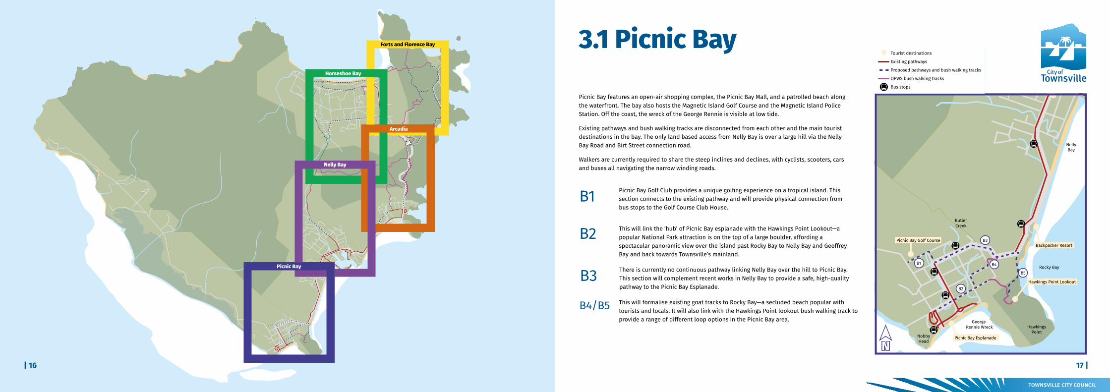
3.4 Forts and Florence BayThis section of the island accommodates remote bays with pristine beaches, spectacular views from lookouts, tourist accommodation, World War II Forts infrastructure, existing pathways and bush walking tracks. While the area is linked to both Horseshoe Bay and Arcadia, there are sections where walkers are required to use high volume roads, or unofficial and unmaintained tracks to access existing facilities.
This will link the Horseshoe Bay Esplanade and the Henry Lawson Street all-tide access bush walking track to the popular Balding Bay and Radical Bay bush walking tracks and the proposed Y2 Forts link bush walking track. It will also formalise a short Horseshoe Bay loop, taking walkers along the beach, through coastal paperbark forest and following a tidal mangrove creek.
Y1
Connecting to existing bush walking tracks commencing from the eastern end of Horseshoe Bay beach, the bush walking track climbs up the northern ridge to Horseshoe Bay range, meandering through dense forest and open eucalyptus woodland before connecting to the Forts Complex.
Y2
The secluded pristine undeveloped bays of Florence Bay and Arthur Bay are ideal for beach swimming and snorkelling, and are popular destinations for those wishing to escape built up environments. Directly linking Florence Bay with the Forts Complex and Horseshoe Bay creates a range of circuit options.
Y3
Y4 Bounding the only road into Horseshoe Bay, this section will provide safe passage from the Forts Junction all the way to the Horseshoe Bay Esplanade.
Picnic Bay Golf Course
Hawkings Point Lookout
Picnic Bay Esplanade
Backpacker Resort
Nelly Bay Ferry Terminal
Supermarket Shops
Commercial Centre & School
Hire Companies
Supermarket Shops
Nelly to Arcadia Track
Arcadia Village
Nelly toArcadia Track
Sphinx Lookout
Alma Bay Beach
Forts Junction
Horseshoe Bay Connection
Arthur Bay
Forts Track
Lookout
Tower Track
Florence Bay Beach
Forts Complex
Horseshoe Bay Ranch
Skate Park
Bungalow BayKoala Village
Horseshoe Bay EspHorseshoe Bay Beach
Radical Bay Beach
Balding Bay Beach
Endevour Creek
Nelly to Arcadia Track
Lagoon
Cockle Bay Reef
Orchard Rocks
Geoffrey Bay
NellyBay
Horseshoe Bay
FlorenceBay
GowrieBay
ArthurBay
Five Beach Bay
Rollingstone Bay
Young Bay
Bolger Bay
HuntingfieldBay Wilson Bay
Joyce Bay
Norris Bay
Maud Bay
Lovers Bay
White Rock
NobbyHead
Cockle Bay
HawkingsPoint
Rocky Bay
BrightPoint
BremnerPoint
WhitfieldCove
The Point
Magnetic IslandNational Park
West Point
Liver Point
Mt Cook493m
RetreatCreek
DuckCreek
Ned LeeCreek
ButlerCreek
GustavCreek
PetersenCreek
White LadyBay
GorgeCreek
George Rennie Wreck
G4
G2
G1
G3
Y2
Y3
Y1
Y4
R4
R3
R1
R2
M1
M2
B1
B2
B4
B3
B5
R5
R6
Y5
G5
Tourist destinations
Existing pathways
Proposed pathways and bush walking tracks
QPWS bush walking tracks
Bus stops
Telstra track
Tourist destinations
Existing pathways
Proposed pathways and bush walking tracks
QPWS bush walking tracks
Bus stops
Pipeline Service Corridor (very steep)
Tourist destinations
Existing pathways
Proposed pathways and bush walking tracks
QPWS bush walking tracks
Bus stops
N
3.5 Horseshoe Bay
A village-like settlement that contains the Island’s premier tourist strip for activities including; horse-riding, watersports, bush walking, sports ovals and a skate park. Set on the water’s edge of uninterrupted pristine beach front, tourists flock here to enjoy the long sunny days on the sand, adventure activities and easy-going restaurants and bars.
The gentle terrain and open areas offer a different experience for trail walkers and there are a range of opportunities for pathway and bush walking track development on both QPWS and TCC tenure.
Following the base of the hills on the edge of the National Park, this section provides a connection loop that creates a longer circuit trail around the bay. It also links into the Pipeline Service Corridor— (a very steep service corridor that is used as an event track for the annual Adventurethon race) allowing a range of different event options.
G1
Taking in the pristine beach front that is Horseshoe Bay, this section provides a circuit walk that connects to the Esplanade’s tourist strip and takes users through natural coastal paperbark forests past the Horseshoe Bay Lagoon.
G2
This will link the Horseshoe Bay Esplanade with the Henry Lawson Street all-tide access bush walking track to the popular Balding Bay and Radical Bay bush walking tracks and the proposed Y2 Forts link bush walking track. It will also formalise a short Horseshoe Bay loop, taking walkers along the beach, through coastal paperbark forest and following a tidal mangrove creek.
G3
G4 Gifford Street is a prominent urban connector in the bay, horse-riding tours are located on this road and traverse the road to the beach.
Bounding the only road into Horseshoe Bay (Horseshoe Bay Road), this section will provide safe passage from the Forts Junction all the way to the Horseshoe Bay Esplanade.
G5
Picnic Bay Golf Course
Hawkings Point Lookout
Picnic Bay Esplanade
Backpacker Resort
Nelly Bay Ferry Terminal
Supermarket Shops
Commercial Centre & School
Hire Companies
Supermarket Shops
Nelly to Arcadia Track
Arcadia Village
Nelly toArcadia Track
Sphinx Lookout
Alma Bay Beach
Forts Junction
Horseshoe Bay Connection
Arthur Bay
Forts Track
Lookout
Tower Track
Florence Bay Beach
Forts Complex
Horseshoe Bay Ranch
Skate Park
Bungalow BayKoala Village
Horseshoe Bay EspHorseshoe Bay Beach
Radical Bay Beach
Balding Bay Beach
Endevour Creek
Nelly to Arcadia Track
Lagoon
Cockle Bay Reef
Orchard Rocks
Geoffrey Bay
NellyBay
Horseshoe Bay
FlorenceBay
GowrieBay
ArthurBay
Five Beach Bay
Rollingstone Bay
Young Bay
Bolger Bay
HuntingfieldBay Wilson Bay
Joyce Bay
Norris Bay
Maud Bay
Lovers Bay
White Rock
NobbyHead
Cockle Bay
HawkingsPoint
Rocky Bay
BrightPoint
BremnerPoint
WhitfieldCove
The Point
Magnetic IslandNational Park
West Point
Liver Point
Mt Cook493m
RetreatCreek
DuckCreek
Ned LeeCreek
ButlerCreek
GustavCreek
PetersenCreek
White LadyBay
GorgeCreek
George Rennie Wreck
G4
G2
G1
G3
Y2
Y3
Y1
Y4
R4
R3
R1
R2
M1
M2
B1
B2
B4
B3
B5
R5
R6
Y5
G5
Tourist destinations
Existing pathways
Proposed pathways and bush walking tracks
QPWS bush walking tracks
Bus stops
Telstra track
Tourist destinations
Existing pathways
Proposed pathways and bush walking tracks
QPWS bush walking tracks
Bus stops
Pipeline Service Corridor (very steep)
Tourist destinations
Existing pathways
Proposed pathways and bush walking tracks
QPWS bush walking tracks
Bus stops
NY5 Radical Bay Road provides vehicle access to a small number of tourist accommodation
dwellings. However, the road is predominately used by walkers.
21 | | 20
4. Tenure 4.1 Responsibility
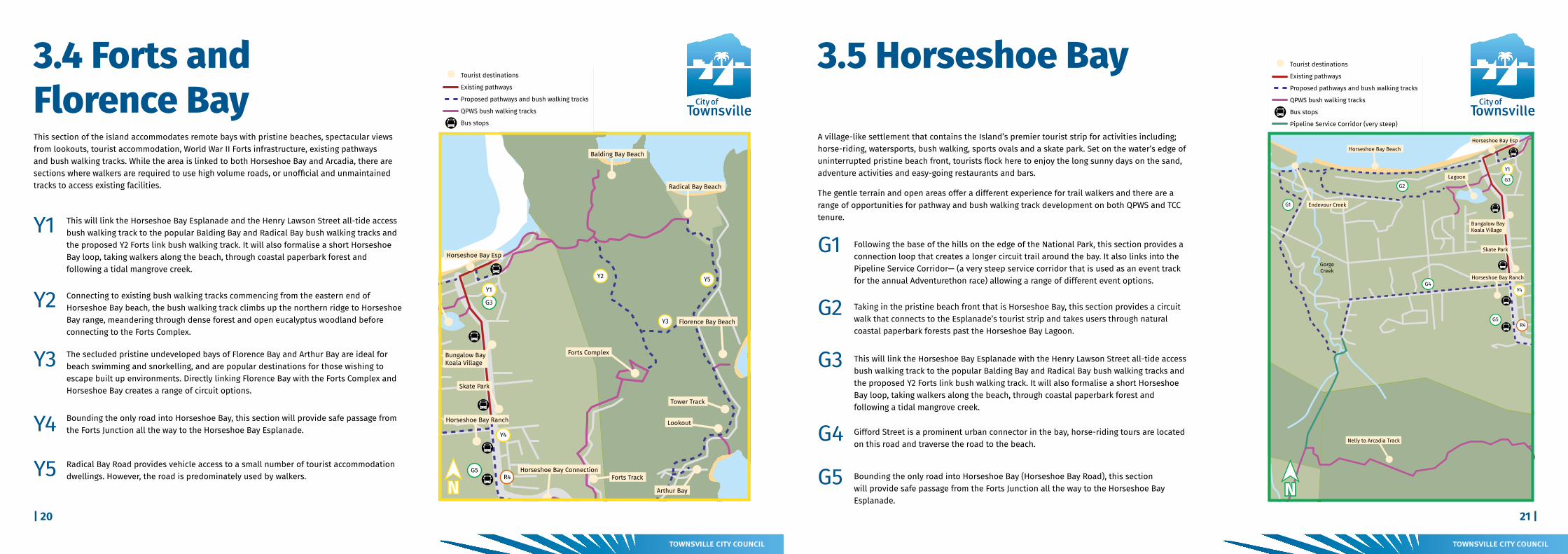
The island trails network crosses many property boundaries, some are located in national park lands whilst others are accommodated in road reserves or parklands. Ownership, as well as maintenance responsibilities, vary from location to location.
To ensure the individual accountabilities are understood moving forward, the responsible agency (or in some cases agencies) have been identified in the following table (Table 1).
Table 1: Responsible AgenciesSection Location Description Responsible Agency
B1 Picnic Bay Granite Street to Golf Course TCC
B2 Picnic Bay Esplanade to Hawkings Point trailhead TCC
B3 Picnic Bay Nelly Bay to Picnic Bay TCC
B4 Picnic Bay Butler Street to Picnic Street TCC
B5 Picnic Bay Rocky Bay Lookout to Hawkings Pt Track QPWS
M1 Nelly Bay Mandalay Ave to Nelly to Arcadia trailhead TCC
M2 Nelly Bay Nelly Bay trailheadTCC, QPWS and
Dept. of Transport and Main Roads
R1 Arcadia Nelly to Arcadia trailhead to Arcadia Village TCC
R2 Arcadia Arcadia Village to Forts Junction QPWS/TCC
R3 Forts Junction Forts Junction intersection upgrade QPWS/TCC
R4/Y4/G5 Horseshoe Bay Telstra Tracks North to Horseshoe Bay Esplanade TCC
R5 Arcadia Bright Ave to Magnetic Island Rd TCC
R6/Y5 Florence Bay Radical Bay Road QPWS/TCC
Y1/G3 Horseshoe Bay Horseshoe Bay Esplanade to Henry Lawson all-tide access track TCC
Y2 Forts Horseshoe Bay to Forts complex QPWS
Y3 Forts/Florence Bay Forts complex to Florence Bay QPWS
G1 Horseshoe Bay Pipeline track to Endeavour Creek QPWS
G2 Horseshoe Bay Horseshoe Bay Beach West loop QPWS/TCC
G4 Horseshoe Bay Gifford Street TCC| 22