Embed Size (px)
Citation preview

General Information
Location: ISTANBUL TURICAO/IATA: LTFJ / SAWLat/Long: N40° 53.90', E029° 18.55'Elevation: 312 ft
Airport Use: PublicDaylight Savings: Not ObservedUTC Conversion: -3:00 = UTCMagnetic Variation: 4.0° E
Fuel Types: Jet A-1Repair Types: Minor Airframe, Minor EngineCustoms: YesAirport Type: IFRLanding Fee: YesControl Tower: YesJet Start Unit: NoLLWS Alert: NoBeacon: Yes
Sunrise: 0517 ZSunset: 1435 Z
Runway Information
Runway: 06Length x Width: 9843 ft x 148 ftSurface Type: concreteTDZ-Elev: 300 ftLighting: Edge, ALS, Centerline, REILStopway: 197 ft
Runway: 24Length x Width: 9843 ft x 148 ftSurface Type: concreteTDZ-Elev: 306 ftLighting: Edge, ALS, Centerline, REILStopway: 197 ft
Communication Information
ATIS: 128.550Gokcen Tower: 120.925Gokcen Tower: 118.800Gokcen Tower: 122.625Gokcen Ground: 122.625 SecondaryGokcen Ground: 121.750Gokcen Clearance Delivery: 122.625Yesilkoy Approach: 127.100
Yesilkoy Approach: 122.675Yesilkoy Approach: 119.475Yesilkoy Approach: 121.100Yesilkoy Approach: 120.500Yesilkoy Approach: 120.450
General Information
Location: ISTANBUL TURICAO/IATA: LTFJ / SAWLat/Long: N40° 53.90', E029° 18.55'Elevation: 312 ft
Airport Use: PublicDaylight Savings: Not ObservedUTC Conversion: -3:00 = UTCMagnetic Variation: 4.0° E
Fuel Types: Jet A-1Repair Types: Minor Airframe, Minor EngineCustoms: YesAirport Type: IFRLanding Fee: YesControl Tower: YesJet Start Unit: NoLLWS Alert: NoBeacon: Yes
Sunrise: 0517 ZSunset: 1435 Z
Runway Information
Runway: 06Length x Width: 9843 ft x 148 ftSurface Type: concreteTDZ-Elev: 300 ftLighting: Edge, ALS, Centerline, REILStopway: 197 ft
Runway: 24Length x Width: 9843 ft x 148 ftSurface Type: concreteTDZ-Elev: 306 ftLighting: Edge, ALS, Centerline, REILStopway: 197 ft
Communication Information
ATIS: 128.550Gokcen Tower: 120.925Gokcen Tower: 118.800Gokcen Tower: 122.625Gokcen Ground: 122.625 SecondaryGokcen Ground: 121.750Gokcen Clearance Delivery: 122.625Yesilkoy Approach: 127.100
Airport Information For LTFJPrinted on 11 Dec 2017Page 1(c) JEPPESEN SANDERSON, INC., 2017, ALL RIGHTS RESERVED
jep=JEPPESEN
JeppView for Windows

General Information
Location: ISTANBUL TURICAO/IATA: LTFJ / SAWLat/Long: N40° 53.90', E029° 18.55'Elevation: 312 ft
Airport Use: PublicDaylight Savings: Not ObservedUTC Conversion: -3:00 = UTCMagnetic Variation: 4.0° E
Fuel Types: Jet A-1Repair Types: Minor Airframe, Minor EngineCustoms: YesAirport Type: IFRLanding Fee: YesControl Tower: YesJet Start Unit: NoLLWS Alert: NoBeacon: Yes
Sunrise: 0517 ZSunset: 1435 Z
Runway Information
Runway: 06Length x Width: 9843 ft x 148 ftSurface Type: concreteTDZ-Elev: 300 ftLighting: Edge, ALS, Centerline, REILStopway: 197 ft
Runway: 24Length x Width: 9843 ft x 148 ftSurface Type: concreteTDZ-Elev: 306 ftLighting: Edge, ALS, Centerline, REILStopway: 197 ft
Communication Information
ATIS: 128.550Gokcen Tower: 120.925Gokcen Tower: 118.800Gokcen Tower: 122.625Gokcen Ground: 122.625 SecondaryGokcen Ground: 121.750Gokcen Clearance Delivery: 122.625Yesilkoy Approach: 127.100
Yesilkoy Approach: 122.675Yesilkoy Approach: 119.475Yesilkoy Approach: 121.100Yesilkoy Approach: 120.500Yesilkoy Approach: 120.450
Yesilkoy Approach: 122.675Yesilkoy Approach: 119.475Yesilkoy Approach: 121.100Yesilkoy Approach: 120.500Yesilkoy Approach: 120.450
Airport Information For LTFJPrinted on 11 Dec 2017Page 2(c) JEPPESEN SANDERSON, INC., 2017, ALL RIGHTS RESERVED
jep=JEPPESEN
JeppView for Windows

ISTANBUL, TURKEYLTFJ/SAWSABIHA GOKCEN INTL .AIRPORT.BRIEFING.
+ JEPPESEN
1.1. ATISATIS 128.550
1.2. SURFACE MOVEMENT GUIDANCE AND CONTROL SYSTEM1.2.1. A-SMGCS UTILISING MODE S
Pilots must ensure that ACFT transponder is set to transmit Mode S signals andassociated Mode A code, from the request for push-back or taxi, whichever isearlier and after landing, continuously until ACFT is fully parked on stand.ACFT operators should ensure that Mode S transponders are able to operate whenACFT is on the ground.Flight crew should select XPNDR or equivalent according to specific installation,AUTO if available, not OFF or STDBY, and the assigned Mode A code, just afterstart-up.After landing, continuously until the ACFT is fully parked on stand, the Mode Acode 2000 must be set before selecting OFF or STDBY.Flight crew of ACFT equipped with Mode S having an ACFT identification featureshould also set the ACFT ident.This setting is the ACFT ident specified in item 7 of the flight plan.The ACFT ident should be entered just after receiving the ATC clearance throughFMS or transponder control panel.Traffic whose transponder is not on and active shall not be instructed for push-back.
1.3. PREFERENTIAL RWY SYSTEM (PRS)Announcement of PRS operations in progress by ATIS.Preferential RWY for landing is RWY 06. Pilots unable to comply with PRS opera-tions for RWY 06 shall notify ATC at first contact or 20 minutes in advance of theETA, whichever is earlier. This traffic may normally be subject to delay. Aircrewmust comply with the requirements announced by ATIS.Preferential RWY for take-off is RWY 06. Pilots unable to comply PRS operationsfor RWY 06 shall notify ATC at the time of start-up clearance. This traffic maynormally be subject to delay.PRS operations shall be used when:- preferred RWY is dry and tailwind component does not exceed 10 KT or;- preferred RWY is wet and tailwind component does not exceed 5 KT.When braking action for the preferred RWY is less than ‘Good, Good, Good’, RWYto be used shall be selected so as to make landing and take-off into the wind.It is the pilot’s decision and responsibility to accept or refuse the use of pre-ferred RWY determined by ATC. If the pilot-in-command requests permission touse a RWY other than the preferred one for landing or take-off operations due tosafety or performance reasons, this request will be met by ATC when it is avail-able. In such cases, ACFT may be subject to delay. ATC shall notify pilots ofdelays expected to exceed 30 minutes.
1.4. MANDATORY IMPLEMENTATION OF RNAV (GNSS) SIDS AND STARSRNAV (GNSS) SIDs AND STARs procedures are mandatory for P-RNAV-approvedACFT. Therefore, the P-RNAV-approved ACFT arriving/departing to/from LTFJ arerequired to flight-plan or submit a change message (CHG) concerning the routesection of their RPLs as described below.
20-1P3 NOV 17 .Eff.9.Nov.
1. GENERAL
| JEPPESEN, 2011, 2017. ALL RIGHTS RESERVED.
Printed from JeppView for Windows 5.3.0.0 on 11 Dec 2017; Terminal chart data cycle 24-2017; Notice: After 14 Dec 2017, 0000Z, this chart may no longer be valid

ISTANBUL, TURKEYLTFJ/SAWSABIHA GOKCEN INTL .AIRPORT.BRIEFING.
+ JEPPESEN
1. GNSS-based RNAV STARs for LTFJ start from the waypoints/fixes TETSA,PAZAR, OTSAN, ELVON, DEKEK, TURKO, GELBU and ATVEP. These waypoints/fixes shall be the last element of the flight-planned routes for the P-RNAV-approved ACFT as illustrated below:- A flight-planned route for the arrivals to LTFJ via RIXEN.
Example: RIXEN UN616 TETSA2. GNSS-based RNAV SIDs for LTFJ end at the waypoints/fixes MARMA, GOLDO,
VADEN, IBLAL, MAKOL, MOPIN, PIMAV, MISRO, ERSEN and TUDBU. These way-points/fixes shall be the first element of the flight-planned routes for the P-RNAV-approved ACFT as illustrated below:- A flight-planned route for the departures from LTFJ via MAKOL.
Example: MAKOL UN617
1.5. TAXI PROCEDURESCAUTION: Due to dense ground movement Flight crew shall
- strictly obey ATC instructions and follow signs on apron and TWYs;- never cross the RWY unless instruction is given by ATC;- comply with read back and hear back procedures.Flocks of sea gulls in vicinity of airport.
Parking areas and positions on apron 1 (9,10,11 and 301-308 VIP), General Avia-tion GAV, M.R.O. and de-icing aprons and parking positions 9,10,11 on apron 1and 301-308 are not seen from Tower. Taxiing, push-back and towing on theseareas under pilot’s responsibility.General Aviation GAV apron is available only for ACFT with MAX wingspan of102’/31m.After vacating RWY wholly, ACFTs shall hold position in the manner that notblocking TWY D and contact with ground control immediately.All ACFT vacating a RWY via Rapid Exit TWY has the priority at the intersectionof the TWYs, over the ACFT taxiing on other TWYs. All pilots shall be cautiousabout this priority and unless otherwise instructed not to do so, give way to theACFT vacating a RWY via one of the Rapid Exit TWYs.Taxiing from apron central line into stands 4A, 6A, 8A, 201, 202, 203, 204, 205,206, 207, 208, 401, 402 and 403 on idle power to avoid jet blast.The part of cargo apron centerline between TWY K and TWY L is available only forCAT D ACFT with small wingspan. CAT E and F ACFT will use TWY L and TWY M for entrance and exit to cargo apron.CAT E and F ACFT will use TWY K for entrance and exit to HABOM Hangar and MyTechnic Hangar. CAT E and F ACFT will not use the part of cargo apron centerlinebetween TWY K and TWY L for taxi.Cat E and F ACFT which is crossing over or exiting RWY using TWY H and U arerequired not to wait on TWY H and U, paying attention to ACFT movement on TWYD. CAT E and F ACFT crossing over RWY between TWY D and cargo apron arerequired not to stop or wait on TWY G and to follow ATC instructions. ACFT to use TWY C shall have MAX speed 5 KT.ACFT shall stop or hold before entering TWY C if required to stop or wait.In case there exists ACFT movement around RWY 24 THR, TWY C shall not be usedfor taxiing in the direction of TWY D to apron 1.
20-1P13 NOV 17 .Eff.9.Nov.
1. GENERAL
| JEPPESEN, 2011, 2017. ALL RIGHTS RESERVED.
Printed from JeppView for Windows 5.3.0.0 on 11 Dec 2017; Terminal chart data cycle 24-2017; Notice: After 14 Dec 2017, 0000Z, this chart may no longer be valid

ISTANBUL, TURKEYLTFJ/SAWSABIHA GOKCEN INTL .AIRPORT.BRIEFING.
+ JEPPESEN
1.5.1. RWY CROSSING PRACTICES1. Towing operations that require RWY crossing shall not be done between 0300-
1200 hours UTC and 1400-2200 hours UTC. Except this timetable, airliners mustapply to Aerodrome Authority for their need of emergency towing for RWYcrossing.
2. ACFT taxiing by their own power shall do RWY crossing at any time by ATCinstructions.
3. Towing operations that require RWY crossing for the purpose of planned main-tenance shall be done between 2200-0300 hours UTC.
1.6. PARKING PROCEDURESStands 201 thru 208 equipped with Automatic Guidance System.Only stand 101 is suitable for B747-8F type of ACFT.
1.7. RUN-UP TESTSEngine test shall be performed between MRO and cargo aprons.Stands 113 and 114 allocated as motor test area at the same time.Engine testing corporation shall contact GOKCEN Delivery on frequency 122.625 MHz before engine test operation. Engine testing ACFT shall be placed properly on ground markings in the test areatowards RWY 24 THR.
2.1. SPEED RESTRICTIONPilots should expect the following speed restrictions to be enforced by ATC:- 200 KT on base leg/closing heading to final approach up to 12NM to touchdown;- 180 KT on final approach course within 12NM to 9NM to touchdown;- 170 KT on final approach course within 9NM to 7NM to touchdown;- 160 KT on final approach course within 7NM to 5NM to touchdown.These speeds are for ATC purposes and are mandatory and have to be flown asaccurately as possible. If unable to comply, inform ATC and state what speed tobe used.
2.2. RWY OPERATIONSAfter landing, flight crew are invited to vacate the RWY as fast and safely aspossible, by using rapid exit TWYs T or F for the RWY 06 and TWYs U or H for theRWY 24. If unable, inform TWR as soon as possible.After landing, it is recommended that vacating RWY from TWY G should beplanned if the vacating the RWY is accurate and safe, otherwise, vacating theRWY by using TWY G shall not be attempted.
2.3. OTHER INFORMATIONLanding of AN124, AN225, C5, A380, B747-8I type ACFT are forbidden to theAPT.B747-8F type of ACFT is required to connect with APT authority for the approvalterms. Landing and take-off permission will be given once a day in low traffichours.
2. ARRIVAL
20-1P23 NOV 17 .Eff.9.Nov.
1. GENERAL
| JEPPESEN, 2015, 2017. ALL RIGHTS RESERVED.
Printed from JeppView for Windows 5.3.0.0 on 11 Dec 2017; Terminal chart data cycle 24-2017; Notice: After 14 Dec 2017, 0000Z, this chart may no longer be valid

ISTANBUL, TURKEYLTFJ/SAWSABIHA GOKCEN INTL .AIRPORT.BRIEFING.
+ JEPPESEN
3.1. DE-ICING AND ANTI-ICINGUnless otherwise noted by the APT Authority. ACFT de-icing and anti-icing appli-cations will be done in areas:While RWY 06 is used for departure:- de-icing applications for CAT C and smaller ACFT will be done in the applica-
tion areas 51, 52, 53, 54;- de-icing applications for CAT D and larger ACFT will be done in TWY S, East
part of apron 1 centerline or cargo apron parking stands.While RWY 24 is used for departure:- de-icing applications for CAT C and smaller ACFT will be done in the applica-
tion area parking stands 14A and 15A and TWY S;- de-icing applications for CAT D and larger ACFT will be done in TWY S, East
part of apron 1 centerline or cargo apron parking stands.ACFT which need de-/anti-icing should submit the status before push backrequest.Pilots shall follow ground markings, marshalling signs and watch vehicles andpersonal movements in de-icing areas. Pilots will keep clearances with minimumdeviation, speed and power while maneuvering in de-icing areas.ACFT which is completed de-icing application shall request clearance beforeentering TWY D and not move without visual sign of clearance by marshaller evenif instructed by ATC to taxi.ACFT which require to wait for de-icing application in the centerline of de-icingapron shall wait at intermediate holding positions D1-HP15 and D1-HP16.
3.2. PUSH-BACK PROCEDURESStandard push-back procedures are mandatory for all parking positions exceptparking positions 14A, 15A, 51, 52, 53 and 54. Power back is forbidden by usingreverse thrust. Unless otherwise notified by ground control, push-back shall bedone to the direction of the RWY-in-use with the exceptions below:- For stand numbers 101, 112 and 113 push-back shall always be done towards
East (nose of ACFT towards RWY 24);- For stand numbers 1 and 2 push-back shall be done to the West (nose of ACFT
will be face to the RWY 06);- For stand numbers 301 and 308, push-back shall be done to apron exit;- For stand numbers 402, 402A, 402B, 403, 403A, 403B, 404, 405, 406 and 407
push-back shall be done to the West (nose of ACFT will be faced to the RWY06);
- ACFT standing at 404 and 405 parking positions, should not start the engineduring push-back, engine start will be done after the ACFT get on the aproncenterline.
3.3. NOISE ABATEMENT PROCEDURESFor departures, any ACFT having compliance with the noise category ICAO Annex 16 Chapter 3 and 4 shall apply NADP-2 whereas all other ACFT whose noisecategory are in compliance with ICAO Annex 16 Chapter 2 shall only apply NADP-1.Pilots shall apply Noise Abatement Departure Procedure 1 or 2 (NADP-1 or NADP-2) which has been explained in ICAO Doc 8168 Vol 1 until passing 3000’.
20-1P33 NOV 17 .Eff.9.Nov.
3. DEPARTURE
| JEPPESEN, 2016, 2017. ALL RIGHTS RESERVED.
Printed from JeppView for Windows 5.3.0.0 on 11 Dec 2017; Terminal chart data cycle 24-2017; Notice: After 14 Dec 2017, 0000Z, this chart may no longer be valid
COMMSLOST COMMSLOST COMMSLOST COMMSLOST COMMSLOST COMMSLOST COMMSLOST COMMSLOST LOST
COMMS
LOST
COMMS
LOST
COMMS
LOST
COMMS
LOST
COMMS
FJ516
FJ517
FJ518
FJ519
IPLIX
BAVUL
PAZAR
KUBAP
TETSA
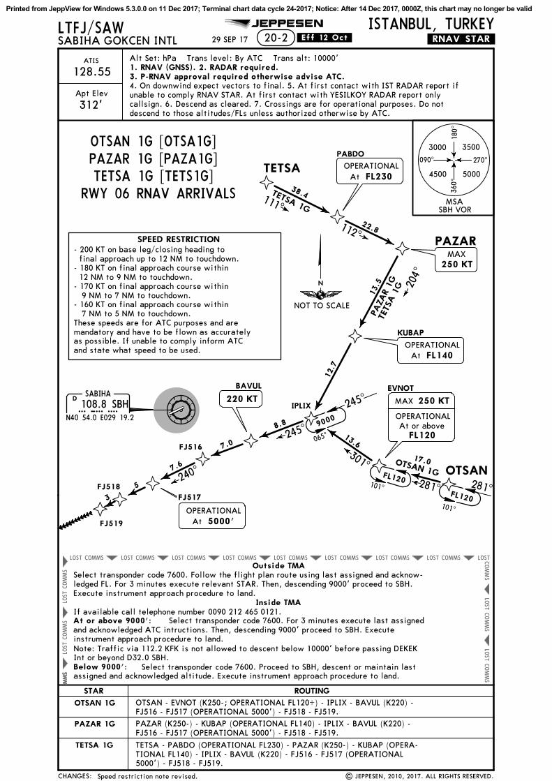
20-2JEPPESEN
Apt Elev
ISTANBUL, TURKEYLTFJ/SAW
312'
ATIS
128.55
.RNAV.STAR.
240^7.6
5
3
245^
204^
8.8
13.5
12.7
111^
22.8
PAZA
R 1
GTE
TSA 1
GD108.8 SBHSBH
N40 54.0 E029 19.2
| JEPPESEN, 2010, 2017. ALL RIGHTS RESERVED.
7.0
38.4TETSA 1G
112^
PABDO
FL230OPERATIONAL
At
SABIHA
MAX250 KT
245^
FL140OPERATIONAL
At
OTSAN
EVNOT
17.0
13.6
301^
281^
OTSAN 1G
29 SEP 17
Alt Set: hPa Trans level: By ATC Trans alt: 10000'1. RNAV (GNSS). 2. RADAR required.3. P-RNAV approval required otherwise advise ATC.4. On downwind expect vectors to final. 5. At first contact with IST RADAR report ifunable to comply RNAV STAR. At first contact with YESILKOY RADAR report onlycallsign. 6. Descend as cleared. 7. Crossings are for operational purposes. Do notdescend to those altitudes/FLs unless authorized otherwise by ATC.
5000'OPERATIONAL
At
220 KT
FL120
OPERATIONALAt or above
MAX 250 KT
.Eff.12.Oct.
Speed restriction note revised.
SABIHA GOKCEN INTL
MSASBH VOR
NOT TO SCALE
CHANGES:
RWY 06 RNAV ARRIVALS
090^ 270^
180^
360^
STAR ROUTING
OTSAN 1G
PAZAR 1G
TETSA 1G
9000
065^
SPEED RESTRICTION
Outside TMA
Inside TMA
At or above 9000':
Below 9000': Select transponder code 7600. Proceed to SBH, descent or maintain lastassigned and acknowledged altitude. Execute instrument approach procedure to land.
Select transponder code 7600. For 3 minutes execute last assignedand acknowledged ATC intructions. Then, descending 9000' proceed to SBH. Executeinstrument approach procedure to land.
TETSA - PABDO (OPERATIONAL FL230) - PAZAR (K250-) - KUBAP (OPERA-TIONAL FL140) - IPLIX - BAVUL (K220) - FJ516 - FJ517 (OPERATIONAL5000') - FJ518 - FJ519.
Select transponder code 7600. Follow the flight plan route using last assigned and acknow-ledged FL. For 3 minutes execute relevant STAR. Then, descending 9000' proceed to SBH.Execute instrument approach procedure to land.
If available call telephone number 0090 212 465 0121.
281^
101^
FL120
101^
FL120
3000 3500
4500 5000
OTSAN 1G [OTSA1G]PAZAR 1G [PAZA1G]TETSA 1G [TETS1G]
PAZAR (K250-) - KUBAP (OPERATIONAL FL140) - IPLIX - BAVUL (K220) -FJ516 - FJ517 (OPERATIONAL 5000') - FJ518 - FJ519.
OTSAN - EVNOT (K250-; OPERATIONAL FL120+) - IPLIX - BAVUL (K220) -FJ516 - FJ517 (OPERATIONAL 5000') - FJ518 - FJ519.
Note: Traffic via 112.2 KFK is not allowed to descent below 10000' before passing DEKEKInt or beyond D32.0 SBH.
- 200 KT on base leg/closing heading to final approach up to 12 NM to touchdown.- 180 KT on final approach course within 12 NM to 9 NM to touchdown.- 170 KT on final approach course within 9 NM to 7 NM to touchdown.- 160 KT on final approach course within 7 NM to 5 NM to touchdown.These speeds are for ATC purposes and aremandatory and have to be flown as accuratelyas possible. If unable to comply inform ATCand state what speed to be used.
Printed from JeppView for Windows 5.3.0.0 on 11 Dec 2017; Terminal chart data cycle 24-2017; Notice: After 14 Dec 2017, 0000Z, this chart may no longer be valid
COMMSLOST COMMSLOST COMMSLOST COMMSLOST COMMSLOST COMMSLOST COMMSLOST COMMSLOST LOST
COMMS
LOST
COMMS
LOST
COMMS
LOST
COMMS
LOST
COMMS
MEBOV
FJ931
PAZAR
JEPPESEN ISTANBUL, TURKEYLTFJ/SAW.RNAV.STAR.
240^330^
9.56
FJ932
FJ933 FJ934
FJ935
33
3
193^
27.2
PA
ZA
R 1
HTETSA
1H
20-2A
OPERATIONALAt 5000'
| JEPPESEN, 2010, 2017. ALL RIGHTS RESERVED.
TETSA
111^
22.8
38.4TETSA 1H
112^
PABDO
060^
Apt Elev
312'
ATIS
128.55
MAX250 KT
PAZAR 1H
D108.8 SBHSBH
N40 54.0 E029 19.2
SABIHA
OTSAN
EVNOT
8.2302^
OPERATIONALAt 9000'
220 KT
29 SEP 17
17.0
281^
OTSAN 1H
MAX250 KT
FL120
OPERATIONALAt or above
Alt Set: hPa Trans level: By ATC Trans alt: 10000'1. RNAV (GNSS). 2. RADAR required.3. P-RNAV approval required otherwise advise ATC.4. On downwind expect vectors to final. 5. At first contact with IST RADAR reportif unable to comply RNAV STAR. At first contact with YESILKOY RADAR report onlycallsign. 6. Descend as cleared. 7. Crossings are for operational purposes. Do notdescend to those altitudes/FLs unless authorized otherwise by ATC.
MAX 250 KT
FL140OPERATIONAL
At
.Eff.12.Oct.
Speed restriction note revised.
SABIHA GOKCEN INTL
MSASBH VOR
NOT TO SCALE
CHANGES:
RWY 24 RNAV ARRIVALS
090^ 270^
180^
360^
STAR ROUTING
OTSAN 1H
PAZAR 1H
TETSA 1H
240^060
^
8000
PAZAR (K250-) - MEBOV (K220; OPERATIONAL 9000') - FJ931 - FJ932(OPERATIONAL 5000') - FJ933 - FJ934 - FJ935.
Outside TMA
Inside TMA
At or above 9000':
Below 9000': Select transponder code 7600. Proceed to SBH, descent or maintain lastassigned and acknowledged altitude. Execute instrument approach procedure to land.
Select transponder code 7600. For 3 minutes execute last assignedand acknowledged ATC intructions. Then, descending 9000' proceed to SBH. Executeinstrument approach procedure to land.
Select transponder code 7600. Follow the flight plan route using last assigned and acknow-ledged FL. For 3 minutes execute relevant STAR. Then, descending 9000' proceed to SBH.Execute instrument approach procedure to land.
If available call telephone number 0090 212 465 0121.
281^
101^
FL120
101^
FL120
4500
3000 3500
5000
Note: Traffic via 112.2 KFK is not allowed to descent below 10000' before passing DEKEKInt or beyond D32.0 SBH.
OTSAN 1H [OTSA1H]PAZAR 1H [PAZA1H]TETSA 1H [TETS1H]
OTSAN (K250-) - EVNOT (OPERATIONAL FL120+) - MEBOV (K220; OPERATIONAL 9000') -FJ931 - FJ932 (OPERATIONAL 5000') - FJ933 - FJ934 - FJ935.
TETSA - PABDO (K250-; OPERATIONAL FL140) - PAZAR - MEBOV (K220; OPERATIONAL9000') - FJ931 - FJ932 (OPERATIONAL 5000') - FJ933 - FJ934 - FJ935.
SPEED RESTRICTION- 200 KT on base leg/closing heading to final approach up to 12 NM to touchdown.- 180 KT on final approach course within 12 NM to 9 NM to touchdown.- 170 KT on final approach course within 9 NM to 7 NM to touchdown.- 160 KT on final approach course within 7 NM to 5 NM to touchdown.These speeds are for ATC purposes and aremandatory and have to be flown as accuratelyas possible. If unable to comply inform ATCand state what speed to be used.
Printed from JeppView for Windows 5.3.0.0 on 11 Dec 2017; Terminal chart data cycle 24-2017; Notice: After 14 Dec 2017, 0000Z, this chart may no longer be valid

COMMSLOST COMMSLOST COMMSLOST COMMSLOST COMMSLOST COMMSLOST COMMSLOST COMMSLOST LOST
COMMS
LOST
COMMS
LOST
COMMS
LOST
COMMS
LOST
COMMS
BUKED
FJ515
FJ516
FJ517
FJ518
FJ519
PIMAV
EKDAM
JEPPESEN ISTANBUL, TURKEYLTFJ/SAW.RNAV.STAR.
273^15.6
7.6
PIMAV 1G
7.6
8
060^
330^
240^7.6
5
3
| JEPPESEN, 2010, 2017. ALL RIGHTS RESERVED.
OPERATIONALAt 5000'
20-2B
Apt Elev
312'
ATIS
128.55
D108.8 SBHSBH
N40 54.0 E029 19.2
SABIHA
29 SEP 17
ELVON
TOBGO
060^
358^
15.5
ELV
ON 1
G
330^
13.0
HOLDINGOVERELVON
MAX 250 KT
OPERATIONALAt FL140
Alt Set: hPa Trans level: By ATC Trans alt: 10000'1. RNAV (GNSS). 2. RADAR required.3. P-RNAV approval required otherwise advise ATC.4. On downwind expect vectors to final. 5. At first contact with IST RADAR reportif unable to comply RNAV STAR. At first contact with YESILKOY RADAR report onlycallsign. 6. Descend as cleared. 7. Crossings are for operational purposes. Do notdescend to those altitudes/FLs unless authorized otherwise by ATC.
OPERATIONALAt FL150
MAX 250 KT
220 KT
.Eff.12.Oct.
Speed restriction note revised.
SABIHA GOKCEN INTL
MSASBH VOR
NOT TO SCALE
CHANGES:
RWY 06 RNAV ARRIVALS090^ 270^
180^
360^
STAR
ELVON 1G
ROUTING
PIMAV 1G
10000
7000
240^
Outside TMA
Inside TMA
At or above 9000':
Below 9000': Select transponder code 7600. Proceed to SBH, descent or maintain lastassigned and acknowledged altitude. Execute instrument approach procedure to land.
Select transponder code 7600. For 3 minutes execute last assignedand acknowledged ATC intructions. Then, descending 9000' proceed to SBH. Executeinstrument approach procedure to land.
Select transponder code 7600. Follow the flight plan route using last assigned and acknow-ledged FL. For 3 minutes execute relevant STAR. Then, descending 9000' proceed to SBH.Execute instrument approach procedure to land.
If available call telephone number 0090 212 465 0121.
178 ^
358^
FL1
50
ELVON (K250-; OPERATIONAL FL150) - TOBGO - BUKED - FJ515 (K220) -FJ516 - FJ517 (OPERATIONAL 5000') - FJ518 - FJ519.
3000 3500
50004500
ELVON 1G [ELVO1G]PIMAV 1G [PIMA1G]
Note: Traffic via 112.2 KFK is not allowed to descent below 10000' before passing DEKEKInt or beyond D32.0 SBH.
PIMAV - EKDAM (K250-; OPERATIONAL FL140) - TOBGO - BUKED - FJ515 (K220) -FJ516 - FJ517 (OPERATIONAL 5000') - FJ518 - FJ519.
SPEED RESTRICTION- 200 KT on base leg/closing heading to final approach up to 12 NM to touchdown.- 180 KT on final approach course within 12 NM to 9 NM to touchdown.- 170 KT on final approach course within 9 NM to 7 NM to touchdown.- 160 KT on final approach course within 7 NM to 5 NM to touchdown.These speeds are for ATC purposes and aremandatory and have to be flown as accuratelyas possible. If unable to comply inform ATCand state what speed to be used.
Printed from JeppView for Windows 5.3.0.0 on 11 Dec 2017; Terminal chart data cycle 24-2017; Notice: After 14 Dec 2017, 0000Z, this chart may no longer be valid

COMMSLOST COMMSLOST COMMSLOST COMMSLOST COMMSLOST COMMSLOST COMMSLOST COMMSLOST LOST
COMMS
LOST
COMMS
LOST
COMMS
LOST
COMMS
LOST
COMMS
DEKEK
FJ515
FJ516
PIMAV
EKDAM
JEPPESEN ISTANBUL, TURKEYLTFJ/SAW.RNAV.STAR.
324^
273^15.6
18.9
10
R144^
R093^
PIMAV 1H
MAX 250 KT
DYALOVA
117.7 YAAYAAN40 28.5 E029 12.5
003^
8.2
57.6
8
060^
330^
FJ513BUKED
9
060^
FJ932
FJ933
FJ934FJ935
33
3
20-2C
| JEPPESEN, 2010, 2017. ALL RIGHTS RESERVED.
OPERATIONALAt FL150
Apt Elev
312'
ATIS
128.55
OPERATIONALAt 5000'
D108.8 SBHSBH
N40 54.0 E029 19.2
SABIHA
29 SEP 17
ELVON
10
ELVON 1
H
OPERATIONALAt FL180
FL150
Alt Set: hPa Trans level: By ATC Trans alt: 10000'1. RNAV (GNSS). 2. RADAR required.3. P-RNAV approval required otherwise advise ATC.4. On downwind expect vectors to final. 5. At first contact with IST RADAR reportif unable to comply RNAV STAR. At first contact with YESILKOY RADAR report onlycallsign. 6. Descend as cleared. 7. Crossings are for operational purposes. Do notdescend to those altitudes/FLs unless authorized otherwise by ATC.
220 KT
.Eff.12.Oct.
Speed restriction note revised.
SABIHA GOKCEN INTL
MSASBH VOR
NOT TO SCALE
CHANGES:
RWY 24 RNAV ARRIVALS090^ 270^
180^
360^
STAR
ELVON 1H
ROUTING
PIMAV 1H
10000
7000
240^
PIMAV - EKDAM (OPERATIONAL FL150) - YAA (K250-) - FJ513 - BUKED - FJ515(K220) - FJ516 - FJ932 (OPERATIONAL 5000') - FJ933 - FJ934 - FJ935.
Outside TMA
Inside TMA
At or above 9000':
Below 9000': Select transponder code 7600. Proceed to SBH, descent or maintain lastassigned and acknowledged altitude. Execute instrument approach procedure to land.
Select transponder code 7600. For 3 minutes execute last assignedand acknowledged ATC intructions. Then, descending 9000' proceed to SBH. Executeinstrument approach procedure to land.
Select transponder code 7600. Follow the flight plan route using last assigned and acknow-ledged FL. For 3 minutes execute relevant STAR. Then, descending 9000' proceed to SBH.Execute instrument approach procedure to land.
If available call telephone number 0090 212 465 0121.
ELVON - DEKEK (OPERATIONAL FL180) - YAA (K250-) - FJ513 - BUKED - FJ515(K220) - FJ516 - FJ932 (OPERATIONAL 5000') - FJ933 - FJ934 - FJ935.
ELVON 1H [ELVO1H], PIMAV 1H [PIMA1H]3000
4500 5000
3500
Note: Traffic via 112.2 KFK is not allowed to descent below 10000' before passing DEKEKInt or beyond D32.0 SBH.
SPEED RESTRICTION- 200 KT on base leg/closing heading to final approach up to 12 NM to touchdown.- 180 KT on final approach course within 12 NM to 9 NM to touchdown.- 170 KT on final approach course within 9 NM to 7 NM to touchdown.- 160 KT on final approach course within 7 NM to 5 NM to touchdown.These speeds are for ATC purposes and aremandatory and have to be flown as accuratelyas possible. If unable to comply inform ATCand state what speed to be used.
Printed from JeppView for Windows 5.3.0.0 on 11 Dec 2017; Terminal chart data cycle 24-2017; Notice: After 14 Dec 2017, 0000Z, this chart may no longer be valid
COMMS
LOST
COMMS
LOST
COMMS
LOST
COMMS
LOST
COMMS
LOST
COMMS
LOST
COMMSLOST
COMMS LOSTCOMMS LOSTLOST
COMMS
LOST
COMMSLOSTCOMMSA
TVEP G
ELB
U
TURKO
FJ51~
FJ511 F
J512
JEPPESEN ISTANBUL, TURKEYLTFJ/SAW.RNAV.STAR.20-2D
FJ513
BUKEDFJ516
FJ517 F
J518
FJ519
5
7.6
8
060^
330^
240^
7.6
5
3
FJ515
15.5
150^10.9
26.6
126^
23.4
079^
089^
33.2
ZEM
BA
GEL
BU 1
G
GELB
U 1
G
TURKO
1G
18.7
140^
122^
51.2
ATV
EP 1
G
MA
X250 K
T
OPE
RATI
ON
AL
At
FL1
90
OPE
RATI
ON
AL
At
5000'
Apt Elev
312'
ATIS
1
1
29 SEP 17 .Eff.12.Oct.
| JEPPESEN, 2011, 2017. ALL RIGHTS RESERVED.
D10
8.8
SBH
SBH
N40
54.0
E029
19.2
SABIHA
128.550 1. RNAV (GNSS). 2. RADAR required.3. P-RNAV approval required otherwise advise ATC.
Alt Set: hPa Trans level: By ATC Trans alt: 10000'
4. On downwind expect vectors to final. 5. At first contact with IST RADAR report ifunable to comply RNAV STAR. At first contact with YESILKOY RADAR reportonly callsign. 6. Descend as cleared. 7. Crossings are for operational purposes.Do not descend to those altitudes/FLs unless authorized otherwise by ATC.
220 K
T
Speed restriction note revised.
SABIHA GOKCEN INTL
MSA
SBH V
OR
CHANGES:
RWY 06 RNAV ARRIVALS 090^
270^
180^ 360^
NO
T TO
SCA
LE
7000
240^
STA
R
ATVEP 1
G
RO
UTIN
G
GELB
U 1
G
TURKO
1G
Outs
ide T
MA
Insid
e T
MA
At
or
above 9
000':
Belo
w 9
000':
GEL
BU -
TURK
O -
FJ5
10 (
OPE
RATI
ON
AL
FL19
0) -
FJ5
11 (
K25
0-)
- FJ
512
- FJ
513
-BUKED
- F
J515
(K22
0) -
FJ5
16 -
FJ5
17 (
OPE
RATI
ON
AL
5000
') -
FJ5
18 -
FJ5
19.
TURK
O -
FJ5
10 (
OPE
RATI
ON
AL
FL19
0) -
FJ5
11 (
K25
0-)
- FJ
512
- FJ
513
- BUKED
-FJ
515
(K22
0) -
FJ5
16 -
FJ5
17 (
OPE
RATI
ON
AL
5000
') -
FJ5
18 -
FJ5
19.
Sele
ct t
rans
pond
er c
ode
7600
. Fo
r 3
min
utes
exe
cute
las
tas
sign
ed a
nd a
ckno
wle
dged
ATC
int
ruct
ions
. Th
en,
desc
endi
ng 9
000'
pro
ceed
to S
BH
. Ex
ecut
e in
stru
men
t ap
proa
ch p
roce
dure
to
land
.
Sele
ct t
rans
pond
er c
ode
7600
. Pr
ocee
d to
SBH
, de
scen
d or
mai
ntai
n la
st a
ssig
ned
and
ackn
owle
dged
alt
itud
e. E
xecu
te i
nstr
umen
t ap
proa
chpr
oced
ure
to l
and.
ATV
EP -
ZEM
BA
- F
J510
(O
PERA
TIO
NA
L FL
190)
- F
J511
(K25
0-)
- FJ
512
- FJ
513
-BUKED
- F
J515
(K22
0) -
FJ5
16 -
FJ5
17 (
OPE
RATI
ON
AL
5000
') -
FJ5
18 -
FJ5
19.
Sele
ct t
rans
pond
er c
ode
7600
. Fo
llow
the
fli
ght
plan
rou
te u
sing
las
t as
sign
edan
d ac
know
ledg
ed F
L. F
or 3
min
utes
exe
cute
rel
evan
t ST
AR.
The
n, d
esce
ndin
g90
00'
proc
eed
to S
BH
. Ex
ecut
e in
stru
men
t ap
proa
ch p
roce
dure
to
land
.
If a
vail
able
cal
l te
leph
one
num
ber
0090
212
465
012
1.
3500
3000
4500
5000ATVEP 1G [ATVE1G]
GELBU 1G [GELB1G]TURKO 1G [TURK1G]
Not
e: T
raff
ic v
ia 1
12.2
KFK
is
not
allo
wed
to
desc
ent
belo
w 1
0000
' be
fore
pass
ing
DEK
EK I
nt o
r be
yond
D32
.0 S
BH.
SPEED R
ESTRIC
TIO
N-
200
KT
on b
ase
leg/
clos
ing
head
ing
to
fina
l ap
proa
ch u
p to
12
NM
to
touc
hdow
n.-
180
KT
on f
inal
app
roac
h co
urse
wit
hin
12
NM
to
9 N
M t
o to
uchd
own.
- 17
0 KT
on f
inal
app
roac
h co
urse
wit
hin
9
NM
to
7 N
M t
o to
uchd
own.
- 16
0 KT
on f
inal
app
roac
h co
urse
wit
hin
7
NM
to
5 N
M t
o to
uchd
own.
Thes
e sp
eeds
are
for
ATC
pur
pose
s an
d ar
em
anda
tory
and
hav
e to
be
flow
n as
acc
urat
ely
as p
ossi
ble.
If
unab
le t
o co
mpl
y in
form
ATC
and
stat
e w
hat
spee
d to
be
used
.
Printed from JeppView for Windows 5.3.0.0 on 11 Dec 2017; Terminal chart data cycle 24-2017; Notice: After 14 Dec 2017, 0000Z, this chart may no longer be valid

COMMS
LOST
COMMS
LOST
COMMS
LOST
COMMS
LOST
COMMS
LOST
COMMS
LOST
COMMSLOST COMMSLOST
COMMS LOSTCOMMS LOST
LOSTCOMMS
LOST
OVDUS
FJ53~
FJ~83
FJ932
FJ933
FJ934
FJ935
TURKO
FJ51~
JEPPESEN ISTANBUL, TURKEYLTFJ/SAW.RNAV.STAR.20-2E
FJ516
26.6
126^
23.4
079^
089^28.9
10
060^
14.3
8.7
9
33
3
ATVEP
GELB
U
ZEM
BA 18
.7
140^
122^
51.2
ATV
EP 1
H
GEL
BU 1
H
GELB
U 1
H
TURKO
1H
MA
X250 K
T
Apt Elev
312'
ATIS
OPE
RATI
ON
AL
At
5000'
29 SEP 17 .Eff.12.Oct.
| JEPPESEN, 2011, 2017. ALL RIGHTS RESERVED.
D10
8.8
SBH
SBH
N40
54.0
E029
19.2
SABIHA
128.550Alt Set: hPa Trans level: By ATC Trans alt: 10000'
4. On downwind expect vectors to final. 5. At first contact with IST RADAR report ifunable to comply RNAV STAR. At first contact with YESILKOY RADAR reportonly callsign. 6. Descend as cleared. 7. Crossings are for operational purposes.Do not descend to those altitudes/FLs unless authorized otherwise by ATC.
1. RNAV (GNSS). 2. RADAR required.3. P-RNAV approval required otherwise advise ATC.
220 K
T
Speed restriction note revised.
SABIHA GOKCEN INTL
MSA
SBH
VO
R
CHANGES:
RWY 24 RNAV ARRIVALS090^
270^
180^ 360^
NO
T TO
SCA
LE
STA
R
ATVEP 1
H
RO
UTIN
G
GELB
U 1
H
TURKO
1H
269^
10000
Outs
ide T
MA
Insid
e T
MA
At
or
above 9
000':
Belo
w 9
000':
Sele
ct t
rans
pond
er c
ode
7600
. Fo
r 3
min
utes
exe
-cu
te l
ast
assi
gned
and
ack
now
ledg
ed A
TC i
ntru
ctio
ns.
Then
, de
scen
ding
9000
' pr
ocee
d to
SBH
. Ex
ecut
e in
stru
men
t ap
proa
ch p
roce
dure
to
land
.
Sele
ct t
rans
pond
er c
ode
7600
. Pr
ocee
d to
SBH
, de
scen
dor
mai
ntai
n la
st a
ssig
ned
and
ackn
owle
dged
alt
itud
e. E
xecu
te i
nstr
umen
tap
proa
ch p
roce
dure
to
land
.
Sele
ct t
rans
pond
er c
ode
7600
. Fo
llow
the
fli
ght
plan
rou
te u
sing
las
tas
sign
ed a
nd a
ckno
wle
dged
FL.
For
3 m
inut
es e
xecu
te r
elev
ant
STA
R.Th
en,
desc
endi
ng 9
000'
pro
ceed
to
SBH
. Ex
ecut
e in
stru
men
t ap
proa
chpr
oced
ure
to l
and.
If a
vail
able
cal
l te
leph
one
num
ber
0090
212
465
012
1.
Not
e: T
raff
ic v
ia 1
12.2
KFK
is
not
allo
wed
to
desc
ent
belo
w 1
0000
'be
fore
pas
sing
DEK
EK I
nt o
r be
yond
D32
.0 S
BH.
3000
3500
4500
5000 ATVEP 1H [ATVE1H]
GELBU 1H [GELB1H]TURKO 1H [TURK1H]
ATV
EP -
ZEM
BA
- F
J510
- O
VD
US
- FJ
530
(K25
0-)
- FJ
083
(K22
0) -
FJ5
16 -
FJ93
2 (O
PERA
TIO
NA
L 50
00')
- F
J933
- F
J934
- F
J935
.
GEL
BU -
TURK
O -
FJ5
10 -
OVD
US
- FJ
530
(K25
0-)
- FJ
083
(K22
0) -
FJ5
16 -
FJ93
2 (O
PERA
TIO
NA
L 50
00')
- F
J933
- F
J934
- F
J935
.
TURK
O -
FJ5
10 -
OVD
US
- FJ
530
(K25
0-)
- FJ
083
(K22
0) -
FJ5
16 -
FJ93
2 (O
PERA
TIO
NA
L 50
00')
- F
J933
- F
J934
- F
J935
.
SPEED R
ESTRIC
TIO
N-
200
KT
on b
ase
leg/
clos
ing
head
ing
to
fina
l ap
proa
ch u
p to
12
NM
to
touc
hdow
n.-
180
KT
on f
inal
app
roac
h co
urse
wit
hin
12
NM
to
9 N
M t
o to
uchd
own.
- 17
0 KT
on f
inal
app
roac
h co
urse
wit
hin
9
NM
to
7 N
M t
o to
uchd
own.
- 16
0 KT
on f
inal
app
roac
h co
urse
wit
hin
7
NM
to
5 N
M t
o to
uchd
own.
Thes
e sp
eeds
are
for
ATC
pur
pose
s an
d ar
em
anda
tory
and
hav
e to
be
flow
n as
acc
urat
ely
as p
ossi
ble.
If
unab
le t
o co
mpl
y in
form
ATC
and
stat
e w
hat
spee
d to
be
used
.
Printed from JeppView for Windows 5.3.0.0 on 11 Dec 2017; Terminal chart data cycle 24-2017; Notice: After 14 Dec 2017, 0000Z, this chart may no longer be valid

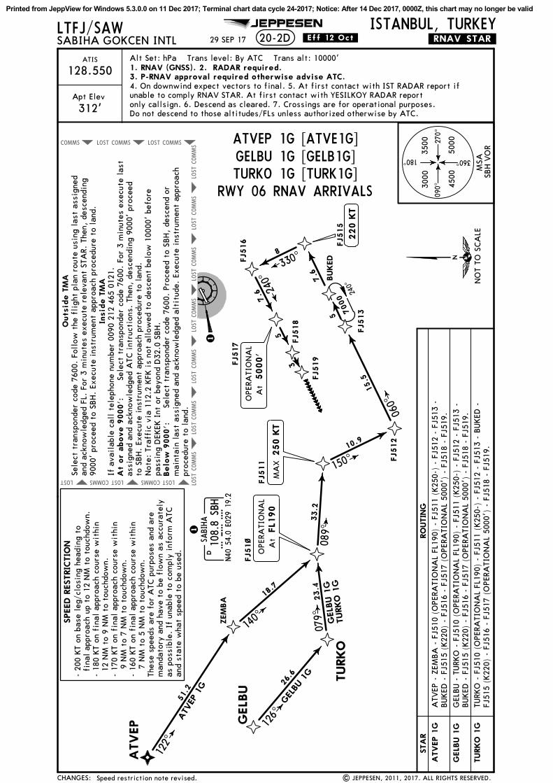
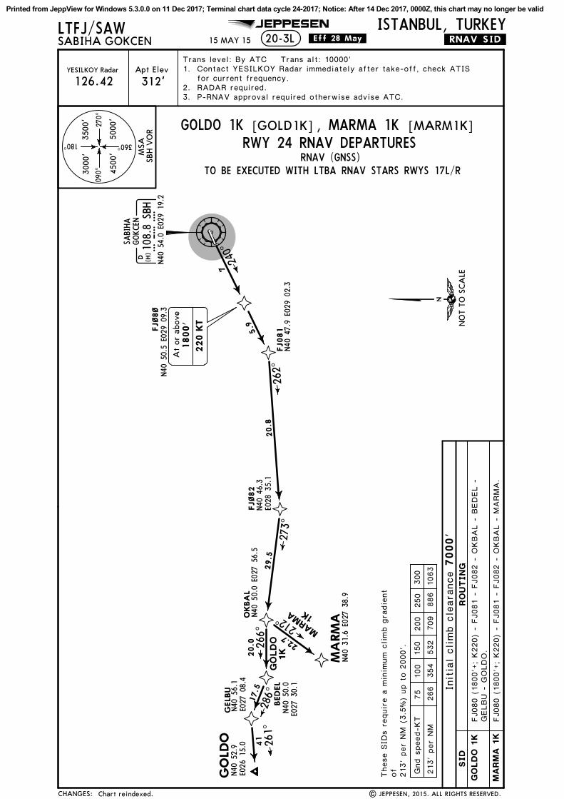
LTFJ/SAW ISTANBUL, TURKEY.RNAV.SID.
JEPPESEN
20 JAN 17 .Eff.2.Feb.20-3
20-3F20-3G
REFER TO CHART
20-3B20-3C20-3D20-3E
20-3H20-3J20-3K20-3L
20-3S20-3T
20-3M20-3N20-3P20-3Q
MAKOL 1J, MOPIN 1J
ERSEN 1J, MISRO 1J, PIMAV 1J
GOLDO 1J, MARMA 1J
GOLDO 1L, MARMA 1LGOLDO 1M, MARMA 1M
RNAV SID DESIGNATION
SABIHA GOKCEN
MAKOL 1K, MOPIN 1KMAKOL 1L, MOPIN 1LMAKOL 1M, MOPIN 1M
ERSEN 1L, MISRO 1L, PIMAV 1LERSEN 1M, MISRO 1M, PIMAV 1M
GOLDO 1K, MARMA 1K
IBLAL 1J, TUDBU 1J, VADEN 1JIBLAL 1K, TUDBU 1K, VADEN 1KIBLAL 1L, TUDBU 1L, VADEN 1LIBLAL 1M, TUDBU 1M, VADEN 1M
REFER TO CHART
20-3U20-3V20-3W20-3X
SID DESIGNATION
BIGA 1F, 1J, 1P, 1WTEKIRDAG 1F, 1J, 1P, 1W
GAYEM 1P, 1W, MOPIN 1F, 1W, YALOVA 1P, 1W
ERTAS 1P, 1W, FENER 1P, 1W
| JEPPESEN, 2015, 2017. ALL RIGHTS RESERVED.
ERSEN 1K, MISRO 1K, PIMAV 1K
EDASA RNAV SIDs renamed MISRO.CHANGES:
Printed from JeppView for Windows 5.3.0.0 on 11 Dec 2017; Terminal chart data cycle 24-2017; Notice: After 14 Dec 2017, 0000Z, this chart may no longer be valid

YASENN41 11.9 E029 31.0
ERTASN41 27.7 E029 08.8
MAKOLN42 10.2 E029 08.6
FJ~7~N40 57.7 E029 29.0
TEMGON41 10.0 E029 20.8
FJ~72N41 17.1 E029 16.0
JEPPESEN
Apt Elev
ISTANBUL, TURKEYLTFJ/SAWSABIHA GOKCEN
312'126.42
.RNAV.SID.
YESILKOY Radar
D108.8 SBHSBH
N40 54.0 E029 19.2
SABIHAGOKCEN
060^
329^ 002^
8
14.3
13.7
MO
PIN
1J
11.9
356^
MOPINN41 27.9 E029 42.6
18.2
025^
220 KT
2200'At or above
8.0
43
(H)
Trans level: By ATC Trans alt: 10000'1. 2.3.
Contact YESILKOY Radar immediately after take-off, check ATISfor current frequency.RADAR required.P-RNAV approval required otherwise advise ATC.
15 MAY 15 .Eff.28.May.
MAKOL 1
J
8000'At or below
20-3B
| JEPPESEN, 2015. ALL RIGHTS RESERVED.RNAV SIDs transferred.
MSASBH VOR
NOT TO SCALE
CHANGES:
RNAV (GNSS)
090^ 270^
180^
360^
3000' 3500'
4500' 5000'
MAKOL 1J
MOPIN 1J
RWY 06 RNAV DEPARTURES
75 100 150 200 250 300Gnd speed-KT
243' per NM 304 405 608 810 1013 1215
These SIDs require a minimum climb gradientof243' per NM (4%) up to 3000'.
FJ070 (2200'+; K220) - TEMGO (8000'-) - FJ072 - ERTAS - MAKOL.
FJ070 (2200'+; K220) - YASEN - MOPIN.
SID ROUTING
Initial climb clearance 7000'
MAKOL 1J [MAKO1J][MOPI1J]MOPIN 1J
Printed from JeppView for Windows 5.3.0.0 on 11 Dec 2017; Terminal chart data cycle 24-2017; Notice: After 14 Dec 2017, 0000Z, this chart may no longer be valid

FJ~8~N40 50.5 E029 09.3
FJ~85N40 54.5 E029 06.7
FJ~86N41 02.5 E029 16.2
LIVSON41 14.1 E029 23.4
ERTASN41 27.7 E029 08.8
MAKOLN42 10.2 E029 08.6
D108.8 SBHSBH
N40 54.0 E029 19.2
SABIHAGOKCEN
240^
356^
7
4.5
330^
220 KT
038^
17.5
20.0
12.8
10.7
021^
042^
317^
MOPI
N 1
K
9000'At or below
MOPIN
MAKOL
1K
43
(H)
210 KT
1800'At or above
JEPPESEN
Apt Elev
ISTANBUL, TURKEYLTFJ/SAWSABIHA GOKCEN
312'126.42
.RNAV.SID.
YESILKOY RadarTrans level: By ATC Trans alt: 10000'1. 2.3.
Contact YESILKOY Radar immediately after take-off, check ATISfor current frequency.RADAR required.P-RNAV approval required otherwise advise ATC.
15 MAY 15 .Eff.28.May.20-3C
| JEPPESEN, 2015. ALL RIGHTS RESERVED.RNAV SIDs transferred; chart redrawn.
N41 27.9 E029 42.6
MSASBH VOR
75 100 150 200 250 300Gnd speed-KT
213' per NM 266 354 532 709 886 1063NOT TO SCALE
These SIDs require a minimum climb gradientof213' per NM (3.5%) up to 2000'.
RNAV (GNSS)RWY 24 RNAV DEPARTURES
TO BE EXECUTED WITH LTBA RNAV STARS RWYS 17L/R
FJ080 (1800'+; K210) - FJ085 (K220) - FJ086 (9000'-) - LIVSO - ERTAS - MAKOL.
FJ080 (1800'+; K210) - FJ085 (K220) - FJ086 (9000'-) - LIVSO - MOPIN.
CHANGES:
090^ 270^
180^
360^
3000' 3500'
4500' 5000'
MAKOL 1K
MOPIN 1K
SID ROUTING
Initial climb clearance 7000'
MAKOL 1K [MAKO1K]MOPIN 1K [MOPI1K]
Printed from JeppView for Windows 5.3.0.0 on 11 Dec 2017; Terminal chart data cycle 24-2017; Notice: After 14 Dec 2017, 0000Z, this chart may no longer be valid

FJ~55
ROBLO
SOMEP
ELKEPN41 16.8 E028 50.5
UBEXAN41 17.2 E029 12.1
FJ~8~N40 50.5 E029 09.3
FJ~81
ERTAS
MAKOLN42 10.2 E029 08.6
D108.8 SBHSBH
N40 54.0 E029 19.2
SABIHAGOKCEN
240^
356^
7
5.9
262^15.8
N40 46.7E028 41.5
353^14.9
9.0
084^
047^
10.0
17.5
16.3
MOPIN 1L
MAKOL
1L 25.3
061^
MOPINN41 27.9E029 42.6
43
(H)
JEPPESEN
Apt Elev
ISTANBUL, TURKEYLTFJ/SAWSABIHA GOKCEN
312'126.42
.RNAV.SID.
YESILKOY RadarTrans level: By ATC Trans alt: 10000'1. 2.3.
Contact YESILKOY Radar immediately after take-off, check ATISfor current frequency.RADAR required.P-RNAV approval required otherwise advise ATC.
15 MAY 15 .Eff.28.May.20-3D
| JEPPESEN, 2015. ALL RIGHTS RESERVED.RNAV SIDs transferred; chart redrawn.
N41 01.6E028 40.6
N41 10.6E028 40.1
N41 27.7 E029 08.8
220 KT
1800'At or above
N40 47.9E029 02.3
MSASBH VOR
75 100 150 200 250 300Gnd speed-KT
213' per NM 266 354 532 709 886 1063 NOT TO SCALE
These SIDs require a minimum climb gradientof213' per NM (3.5%) up to 2000'.
RNAV (GNSS)RWY 24 RNAV DEPARTURES
CHANGES:
090^ 270^
180^
360^
3000' 3500'
4500' 5000'
MAKOL 1L
MOPIN 1L
SID ROUTING
Initial climb clearance 7000'
TO BE EXECUTED WITH LTBA RNAV STARS RWY 23
MOPIN 1L [MOPI1L]MAKOL 1L [MAKO1L]
FJ080 (1800'+; K220) - FJ081 - FJ055 - ROBLO - SOMEP - ELKEP - ERTAS -MAKOL.
FJ080 (1800'+; K220) - FJ081 - FJ055 - ROBLO - SOMEP - ELKEP - UBEXA -MOPIN.
Printed from JeppView for Windows 5.3.0.0 on 11 Dec 2017; Terminal chart data cycle 24-2017; Notice: After 14 Dec 2017, 0000Z, this chart may no longer be valid

VATOMN40 59.1 E029 06.4
FJ~8~N40 50.5 E029 09.3
D117.3 BKZBKZ
N41 07.6 E029 08.6
240^7
JEPPESEN ISTANBUL, TURKEYLTFJ/SAWSABIHA GOKCEN .RNAV.SID.20-3E
ERTASN41 27.7 E029 08.8
MAKOLN42 10.2 E029 08.6
356^
356^
20.1
MA
KO
L 1
M
8.6
007^
R187
^
342^8.9
D108.8 SBHSBH
N40 54.0 E029 19.2
SABIHAGOKCEN
BEYKOZ
7000'At or below
MOPINN41 27.9 E029 42.6
32.7
MOPI
N 1M
047^
43
(H)
(H)
Apt Elev
312'126.42YESILKOY Radar
Trans level: By ATC Trans alt: 10000'1. 2.3.
Contact YESILKOY Radar immediately after take-off, check ATISfor current frequency.RADAR required.P-RNAV approval required otherwise advise ATC.
15 MAY 15 .Eff.28.May.
RNAV SIDs transferred. | JEPPESEN, 2015. ALL RIGHTS RESERVED.
220 KT
1800'At or above
MSASBH VOR
NOT TO SCALE
CHANGES:
RNAV (GNSS)
090^ 270^
180^
360^
3000' 3500'
4500' 5000'
SID ROUTING
Initial climb clearance 7000'
RWY 24 RNAV DEPARTURES
75 100 150 200 250 300Gnd speed-KT
213' per NM 266 354 532 709 886 1063
TO BE EXECUTED WITH LTBA RNAV STARS RWY 35L/R
MAKOL 1M
MOPIN 1M
FJ080 (1800'+; K220) - VATOM (7000'-) - BKZ - ERTAS - MAKOL.
FJ080 (1800'+; K220) - VATOM (7000'-) - BKZ - MOPIN.
These SIDs require a minimum climbgradient of213' per NM (3.5%) up to 2000'.
MOPIN 1M [MOPI1M]MAKOL 1M [MAKO1M]
Printed from JeppView for Windows 5.3.0.0 on 11 Dec 2017; Terminal chart data cycle 24-2017; Notice: After 14 Dec 2017, 0000Z, this chart may no longer be valid
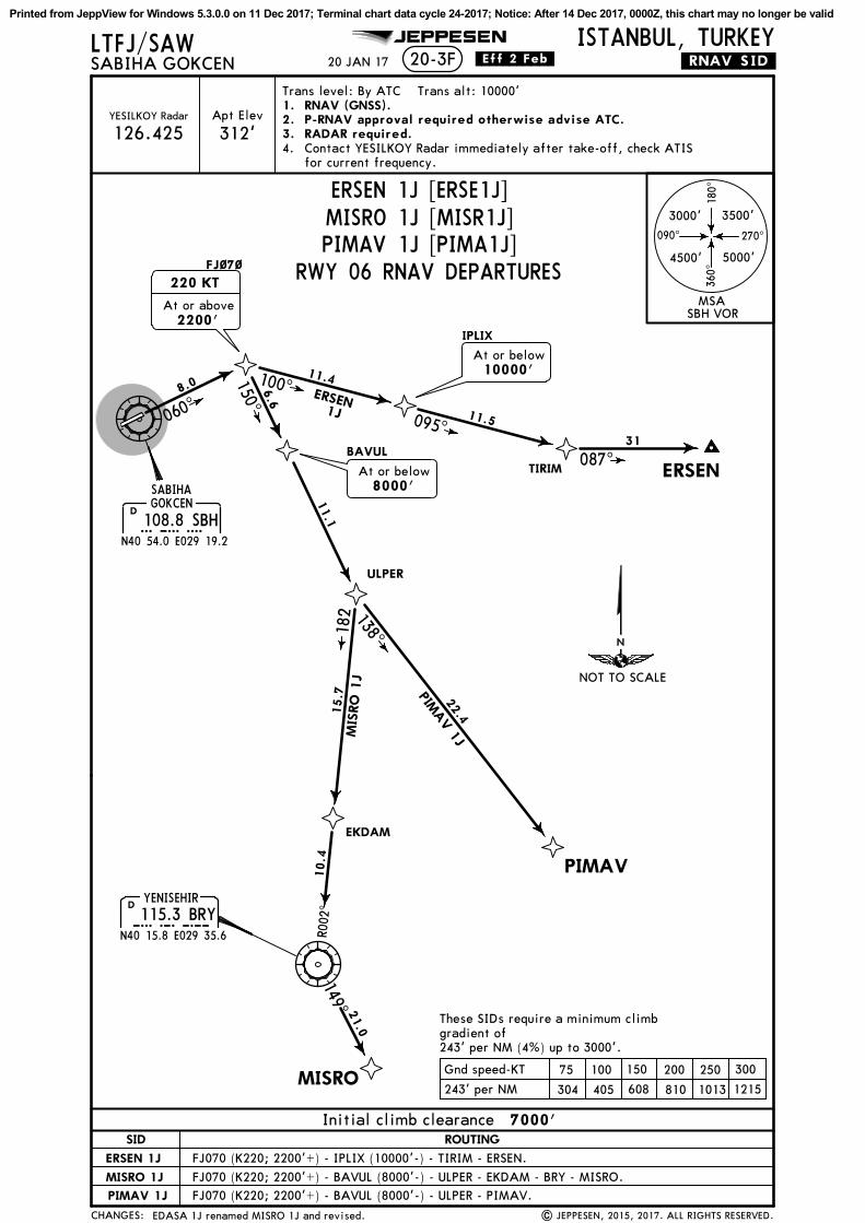
PIMAV
ERSENBAVUL
IPLIX
TIRIM
ULPER
EKDAM
FJ~7~
JEPPESEN ISTANBUL, TURKEYLTFJ/SAWSABIHA GOKCEN .RNAV.SID.
D108.8 SBHSBH
N40 54.0 E029 19.2
SABIHAGOKCEN
060^
20-3F
100^150^
087^
11.5
11.4
6.6
11.1
22.415.7
10.4
8000'At or below
138^
PIMAV 1J
182
R002
^DYENISEHIR
115.3 BRYBRYN40 15.8 E029 35.6
ERSEN1J
10000'At or below
220 KT
2200'At or above
31
MIS
RO
1J
Trans level: By ATC Trans alt: 10000'
20 JAN 17 .Eff.2.Feb.
095^
8.0
| JEPPESEN, 2015, 2017. ALL RIGHTS RESERVED.
149^
MISRO
21.0
Contact YESILKOY Radar immediately after take-off, check ATISfor current frequency.
RNAV (GNSS).P-RNAV approval required otherwise advise ATC.RADAR required.
1.2.3.4.
Apt Elev
312'YESILKOY Radar
126.425
EDASA 1J renamed MISRO 1J and revised.
MSASBH VOR
NOT TO SCALE
CHANGES:
090^ 270^
180^
360^
3000' 3500'
4500' 5000'
SID ROUTING
ERSEN 1J
PIMAV 1J
Initial climb clearance 7000'
RWY 06 RNAV DEPARTURES
75 100 150 200 250 300Gnd speed-KT
243' per NM 304 405 608 810 1013 1215
FJ070 (K220; 2200'+) - BAVUL (8000'-) - ULPER - PIMAV.
FJ070 (K220; 2200'+) - IPLIX (10000'-) - TIRIM - ERSEN.
MISRO 1J FJ070 (K220; 2200'+) - BAVUL (8000'-) - ULPER - EKDAM - BRY - MISRO.
These SIDs require a minimum climbgradient of243' per NM (4%) up to 3000'.
MISRO 1J [MISR1J]ERSEN 1J [ERSE1J]
PIMAV 1J [PIMA1J]
Printed from JeppView for Windows 5.3.0.0 on 11 Dec 2017; Terminal chart data cycle 24-2017; Notice: After 14 Dec 2017, 0000Z, this chart may no longer be valid
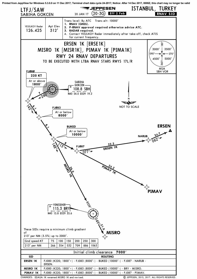
BUKED
FJ~83
FJ~87
NARUB
JEPPESEN ISTANBUL, TURKEYLTFJ/SAWSABIHA GOKCEN .RNAV.SID.20-3G
FJ~8~
D108.8 SBHSBH
N40 54.0 E029 19.2
SABIHAGOKCEN
240^7
142^
8.1
6.1
8000'At or below
10000'At or below
8113^
077^
PIMAV
DYENISEHIR
115.3 BRYBRYN40 15.8 E029 35.6
24.2PIMAV 1K
ERSEN
22.2
ERSEN 1K
062^
148^
R328^
26.0
MISRO
1K
MISRO
Trans level: By ATC Trans alt: 10000'
20 JAN 17 .Eff.2.Feb.
| JEPPESEN, 2015, 2017. ALL RIGHTS RESERVED.
149^ 21.0
1.2.3.
RNAV (GNSS).P-RNAV approval required otherwise advise ATC.RADAR required.Contact YESILKOY Radar immediately after take-off, check ATISfor current frequency.
4.
Apt Elev
312'YESILKOY Radar
126.425
220 KT
1800'At or above
34.7
EDASA 1K renamed MISRO 1K and revised.
MSASBH VOR
CHANGES:
090^ 270^
180^
360^
3000' 3500'
4500' 5000'
SID ROUTING
ERSEN 1K
PIMAV 1K
Initial climb clearance 7000'
RWY 24 RNAV DEPARTURES
75 100 150 200 250 300Gnd speed-KT
213' per NM 266 354 532 709 886 1063
ERSEN.
NOT TO SCALE
TO BE EXECUTED WITH LTBA RNAV STARS RWYS 17L/R
FJ080 (K220; 1800'+) - FJ083 (8000'-) - BUKED (10000'-) - FJ087 - NARUB -
FJ080 (K220; 1800'+) - FJ083 (8000'-) - BUKED (10000'-) - FJ087 - PIMAV.
These SIDs require a minimum climb gradientof213' per NM (3.5%) up to 2000'.
MISRO 1K FJ080 (K220; 1800'+) - FJ083 (8000'-) - BUKED (10000'-) - BRY - MISRO.
ERSEN 1K [ERSE1K], PIMAV 1K [PIMA1K]MISRO 1K [MISR1K]
Printed from JeppView for Windows 5.3.0.0 on 11 Dec 2017; Terminal chart data cycle 24-2017; Notice: After 14 Dec 2017, 0000Z, this chart may no longer be valid

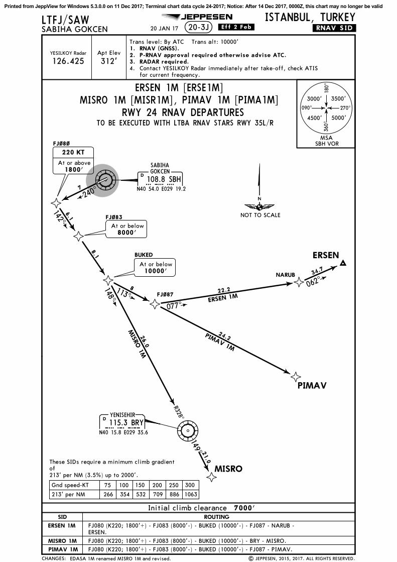
BUKED
FJ~83
FJ~87
NARUB
JEPPESEN ISTANBUL, TURKEYLTFJ/SAWSABIHA GOKCEN .RNAV.SID.20-3H
FJ~8~
D108.8 SBHSBH
N40 54.0 E029 19.2
SABIHAGOKCEN
240^7
142^
8.1
6.1
8000'At or below
10000'At or below
8113^
077^
PIMAV
DYENISEHIR
115.3 BRYBRYN40 15.8 E029 35.6
24.2PIMAV 1L
ERSEN
22.2
ERSEN 1L
062^
148^
R328^
26.0
220 KT
1800'At or above
MISRO
1L
Trans level: By ATC Trans alt: 10000'
20 JAN 17 .Eff.2.Feb.
| JEPPESEN, 2015, 2017. ALL RIGHTS RESERVED.
MISRO
149^ 21.0
RNAV (GNSS).P-RNAV approval required otherwise advise ATC.RADAR required.
1.2.3.
Contact YESILKOY Radar immediately after take-off, check ATISfor current frequency.
4.
Apt Elev
312'YESILKOY Radar
126.425
34.7
EDASA 1L renamed MISRO 1L and revised.
MSASBH VOR
CHANGES:
090^ 270^
180^
360^
3000' 3500'
4500' 5000'
SID ROUTING
ERSEN 1L
PIMAV 1L
Initial climb clearance 7000'
RWY 24 RNAV DEPARTURES
75 100 150 200 250 300Gnd speed-KT
213' per NM 266 354 532 709 886 1063
NOT TO SCALE
TO BE EXECUTED WITH LTBA RNAV STARS RWY 23
FJ080 (K220; 1800'+) - FJ083 (8000'-) - BUKED (10000'-) - FJ087 - NARUB -ERSEN.
FJ080 (K220; 1800'+) - FJ083 (8000'-) - BUKED (10000'-) - FJ087 - PIMAV.
These SIDs require a minimum climb gradientof213' per NM (3.5%) up to 2000'.
MISRO 1L FJ080 (K220; 1800'+) - FJ083 (8000'-) - BUKED (10000'-) - BRY - MISRO.
ERSEN 1L [ERSE1L]MISRO 1L [MISR1L], PIMAV 1L [PIMA1L]
Printed from JeppView for Windows 5.3.0.0 on 11 Dec 2017; Terminal chart data cycle 24-2017; Notice: After 14 Dec 2017, 0000Z, this chart may no longer be valid
BUKED
FJ~83
FJ~87
NARUB
JEPPESEN ISTANBUL, TURKEYLTFJ/SAWSABIHA GOKCEN .RNAV.SID.20-3J
FJ~8~
D108.8 SBHSBH
N40 54.0 E029 19.2
SABIHAGOKCEN
240^7
142^
8.1
6.1
8000'At or below
10000'At or below
8113^
077^
PIMAV
DYENISEHIR
115.3 BRYBRYN40 15.8 E029 35.6
24.2PIMAV 1M
ERSEN
22.2
ERSEN 1M
062^
148^
R328^
26.0
220 KT
1800'At or above
MISRO
1M
Trans level: By ATC Trans alt: 10000'
20 JAN 17 .Eff.2.Feb.
| JEPPESEN, 2015, 2017. ALL RIGHTS RESERVED.
MISRO
21.0
149^
RNAV (GNSS).P-RNAV approval required otherwise advise ATC.RADAR required.Contact YESILKOY Radar immediately after take-off, check ATISfor current frequency.
1.2.3.4.
Apt Elev
312'YESILKOY Radar
126.425
34.7
EDASA 1M renamed MISRO 1M and revised.
MSASBH VOR
CHANGES:
090^ 270^
180^
360^
3000' 3500'
4500' 5000'
SID ROUTING
ERSEN 1M
PIMAV 1M
Initial climb clearance 7000'
RWY 24 RNAV DEPARTURES
75 100 150 200 250 300Gnd speed-KT
213' per NM 266 354 532 709 886 1063
NOT TO SCALE
FJ080 (K220; 1800'+) - FJ083 (8000'-) - BUKED (10000'-) - FJ087 - NARUB -ERSEN.
FJ080 (K220; 1800'+) - FJ083 (8000'-) - BUKED (10000'-) - FJ087 - PIMAV.
These SIDs require a minimum climb gradientof213' per NM (3.5%) up to 2000'.
TO BE EXECUTED WITH LTBA RNAV STARS RWY 35L/R
MISRO 1M FJ080 (K220; 1800'+) - FJ083 (8000'-) - BUKED (10000'-) - BRY - MISRO.
ERSEN 1M [ERSE1M]MISRO 1M [MISR1M], PIMAV 1M [PIMA1M]
Printed from JeppView for Windows 5.3.0.0 on 11 Dec 2017; Terminal chart data cycle 24-2017; Notice: After 14 Dec 2017, 0000Z, this chart may no longer be valid

GELB
U
EM
PO
PN41
14.9
E029
02.3
FJ~74
N41
11.6
E028
42.6
ERLE
BN41
07.3
E028
33.3
OKBA
LN40
50.0
E027
56.5
BEDEL
GO
LDO
MA
RM
AN40
31.6
E027
38.9
JEPPESEN ISTANBUL, TURKEYLTFJ/SAWSABIHA GOKCEN .RNAV.SID.20-3K
FJ~7~
N40
57.7
E029
29.0
TEM
GO
N41
10.0
E029
20.8
FJ~72
N41
17.1
E029
16.0
D10
8.8
SBH
SBH
N40
54.0
E029
19.2
SABIHA
GOKCE
N
060^
329^
8
13.7
8000'
At
or b
elow
254^
253^
234^
10.5
15.2
8.3
32.8
N40
50.0
E027
30.1
N40
56.1
E027
08.4
N40
52.9
E026
15.0
22.7
212^
266^
286^
MARMA 1J
GO
LD
O1J
17.5
261^
220 K
T
2200'
At
or a
bove
8.0
20.0
41
(H)
Apt Elev
312'126.42YESILKOY Radar
Trans level: By ATC Trans alt: 10000'1. 2.3.
Contact YESILKOY Radar immediately after take-off, check ATISfor current frequency.RADAR required.P-RNAV approval required otherwise advise ATC.
Chart reindexed. | JEPPESEN, 2015. ALL RIGHTS RESERVED.
15 MAY 15 .Eff.28.May.
MSA
SBH
VO
R
CHANGES:
RNAV (GNSS)
090^
270^
180^ 360^
3000
'35
00'
4500
'50
00'
RWY 06 RNAV DEPARTURES
TO WEST
NO
T TO
SCA
LE
SID
GO
LD
O 1
J
RO
UT
IN
G
MA
RM
A 1
J
Initia
l climb c
leara
nce
7000'
75
100
150
200
250
300
Gnd s
peed-K
T
243' per
NM
304
405
608
810
1013
1215
FJ074 -
ERLEB -
OKBAL -
BEDEL -
GELBU -
GOLDO.
FJ074 -
ERLEB -
OKBAL -
MARM
A.
GOLDO 1J [GOLD1J] , MARMA 1J [MARM1J]
These S
IDs r
equire a
min
imum c
limb g
radie
nt
of
243' per
NM
(4%)
up t
o 3
000'.
FJ070 (
2200'+
; K220)
- TEM
GO (
8000'-
) -
FJ072 -
EM
POP -
FJ070 (
2200'+
; K220)
- TEM
GO (
8000'-
) -
FJ072 -
EM
POP -
Printed from JeppView for Windows 5.3.0.0 on 11 Dec 2017; Terminal chart data cycle 24-2017; Notice: After 14 Dec 2017, 0000Z, this chart may no longer be valid
GELB
U
OKBA
LN40
50.0
E027
56.5
BEDEL
GO
LDO
MA
RM
AN40
31.6
E027
38.9
JEPPESEN ISTANBUL, TURKEYLTFJ/SAWSABIHA GOKCEN .RNAV.SID.20-3L
N40
50.0
E027
30.1
N40
56.1
E027
08.4
N40
52.9
E026
15.0
22.7
212^
266^
286^
MARMA 1K
GO
LD
O1K
17.5
261^
FJ~8~
N40
50.5
E029
09.3
FJ081
N40
47.9
E029
02.3
FJ~82
D10
8.8
SBH
SBH
N40
54.0
E029
19.2
SABIHA
GOKCE
N
240^
7
5.9
262^
20.8
N40
46.3
E028
35.1
273^
29.5
20.0
220 K
T
1800'
At
or a
bove
41
(H)
Apt Elev
312'126.42YESILKOY Radar
Trans level: By ATC Trans alt: 10000'1. 2.3.
Contact YESILKOY Radar immediately after take-off, check ATISfor current frequency.RADAR required.P-RNAV approval required otherwise advise ATC.
Chart reindexed.
15 MAY 15 .Eff.28.May.
| JEPPESEN, 2015. ALL RIGHTS RESERVED.
MSA
SBH
VO
R
CHANGES:
RNAV (GNSS)
090^
270^
180^ 360^
3000
'35
00'
4500
'50
00'
RWY 24 RNAV DEPARTURES
NO
T TO
SCA
LESID
GO
LD
O 1
K
RO
UT
IN
G
MA
RM
A 1
K
Initia
l climb c
leara
nce
7000'
GOLDO 1K [GOLD1K] , MARMA 1K [MARM1K]
TO BE EXECUTED WITH LTBA RNAV STARS RWYS 17L/R
75
100
150
200
250
300
Gnd s
peed-K
T
213' per
NM
266
354
532
709
886
1063
GELBU -
GOLDO.
These S
IDs r
equire a
min
imum c
limb g
radie
nt
of
213' per
NM
(3.5
%)
up t
o 2
000'.
FJ080 (
1800'+
; K220)
- FJ081 -
FJ082 -
OKBAL -
BEDEL -
FJ080 (
1800'+
; K220)
- FJ081 -
FJ082 -
OKBAL -
MARM
A.
Printed from JeppView for Windows 5.3.0.0 on 11 Dec 2017; Terminal chart data cycle 24-2017; Notice: After 14 Dec 2017, 0000Z, this chart may no longer be valid

GELB
U
OKBA
LN40
50.0
E027
56.5
BEDEL
GO
LDO
MA
RM
AN40
31.6
E027
38.9
JEPPESEN ISTANBUL, TURKEYLTFJ/SAWSABIHA GOKCEN .RNAV.SID.20-3M
N40
50.0
E027
30.1
N40
56.1
E027
08.4
N40
52.9
E026
15.0
22.7
212^
266^
286^
MARMA 1L
GO
LD
O1L
17.5
261^
FJ~8~
N40
50.5
E029
09.3
FJ081
N40
47.9
E029
02.3
FJ~82
D10
8.8
SBH
SBH
N40
54.0
E029
19.2
SABIHA
GOKCE
N
240^
7
5.9
262^
20.8
N40
46.3
E028
35.1
273^
29.5
20.0
220 K
T
1800'
At
or a
bove
41
(H)
Apt Elev
312'126.42YESILKOY Radar
Trans level: By ATC Trans alt: 10000'1. 2.3.
Contact YESILKOY Radar immediately after take-off, check ATISfor current frequency.RADAR required.P-RNAV approval required otherwise advise ATC.
Chart reindexed. | JEPPESEN, 2015. ALL RIGHTS RESERVED.
15 MAY 15 .Eff.28.May.
MSA
SBH V
OR
CHANGES:
RNAV (GNSS)
090^
270^
180^ 360^
3000
'35
00'
4500
'50
00'
RWY 24 RNAV DEPARTURES
NO
T TO
SCA
LESID
GO
LD
O 1
L
RO
UT
IN
G
MA
RM
A 1
L
Initia
l climb c
leara
nce
7000'
GOLDO 1L [GOLD1L] , MARMA 1L [MARM1L]
75
100
150
200
250
300
Gnd s
peed-K
T
213' per
NM
266
354
532
709
886
1063
TO BE EXECUTED WITH LTBA RNAV STARS RWY 23
FJ080 (
1800'+
; K220)
- FJ081 -
FJ082 -
OKBAL -
BEDEL -
GELBU -
GOLDO.
FJ080 (
1800'+
; K220)
- FJ081 -
FJ082 -
OKBAL -
MARM
A.
These S
IDs r
equire a
min
imum c
limb g
radie
nt
of
213' per
NM
(3.5
%)
up t
o 2
000'.
Printed from JeppView for Windows 5.3.0.0 on 11 Dec 2017; Terminal chart data cycle 24-2017; Notice: After 14 Dec 2017, 0000Z, this chart may no longer be valid

FJ~74
N41
11.6
E028
42.6
ERLE
BN41
07.3
E028
33.3
JEPPESEN ISTANBUL, TURKEYLTFJ/SAWSABIHA GOKCEN .RNAV.SID.20-3N
GELB
U
OKBA
LN40
50.0
E027
56.5
BEDEL
GO
LDO
MA
RM
AN40
31.6
E027
38.9
N40
50.0
E027
30.1
N40
56.1
E027
08.4
N40
52.9
E026
15.0
22.7
212^
266^
286^
MARMA 1M
GO
LD
O1M
17.5
261^
20.0
EM
PO
P
FJ~8~
N40
50.5
E029
09.3
240^
7
16.0342^
345^
8.9
D10
8.8
SBH
SBH
N40
54.0
E029
19.2
SABIHA
GOKCE
N
253^
234^
15.2
8.3
32.8
N41
14.9
E029
02.3
220 K
T
1800'
At
or a
bove
VA
TO
MN40
59.1
E029
06.4
7000'
At
or b
elow
41
(H)
Chart reindexed.
Apt Elev
312'126.42YESILKOY Radar
Trans level: By ATC Trans alt: 10000'1. 2.3.
Contact YESILKOY Radar immediately after take-off, check ATISfor current frequency.RADAR required.P-RNAV approval required otherwise advise ATC.
| JEPPESEN, 2015. ALL RIGHTS RESERVED.
15 MAY 15 .Eff.28.May.
MSA
SBH
VO
R
CHANGES:
RNAV (GNSS)
090^
270^
180^ 360^
3000
'35
00'
4500
'50
00'
RWY 24 RNAV DEPARTURES
NO
T TO
SCA
LE
SID
GO
LD
O 1
M
RO
UT
IN
G
MA
RM
A 1
M
Initia
l climb c
leara
nce
7000'
GOLDO 1M [GOLD1M] , MARMA 1M [MARM1M]
75
100
150
200
250
300
Gnd s
peed-K
T
213' per
NM
266
354
532
709
886
1063
ERLEB -
OKBAL -
BEDEL -
GELBU -
GOLDO.
ERLEB -
OKBAL -
MARM
A.
These S
IDs r
equire a
min
imum c
limb g
radie
nt
of
213' per
NM
(3.5
%)
up t
o 2
000'.
FJ080 (
1800'+
; K220)
- VATOM
(7000'-
) -
EM
POP -
FJ074 -
FJ080 (
1800'+
; K220)
- VATOM
(7000'-
) -
EM
POP -
FJ074 -
TO BE EXECUTED WITH LTBA RNAV STARS RWY 35L/R
Printed from JeppView for Windows 5.3.0.0 on 11 Dec 2017; Terminal chart data cycle 24-2017; Notice: After 14 Dec 2017, 0000Z, this chart may no longer be valid

RIMBO
VADEN
FJ~7~N40 57.7 E029 29.0
TEMGON41 10.0 E029 20.8
FJ~72N41 17.1 E029 16.0
PEMET
JEPPESEN
Apt Elev
ISTANBUL, TURKEYLTFJ/SAWSABIHA GOKCEN
312'126.42
.RNAV.SID.
YESILKOY Radar
D108.8 SBHSBH
N40 54.0 E029 19.2
SABIHAGOKCEN
060^
329^
8
13.7
8000'At or below
23.8
72.7
276^
301^
N41 18.7E029 04.3
N41 22.9E028 33.1
IBLALN41 58.9 E028 00.1
8.0
9.0
N41 29.2E028 37.1
AYFER23.0
293^
N42 03.9E027 13.0
(H)
Trans level: By ATC Trans alt: 10000'1. 2.3.
Contact YESILKOY Radar immediately after take-off, check ATISfor current frequency.RADAR required.P-RNAV approval required otherwise advise ATC.
20-3P15 MAY 15 .Eff.28.May.
220 KT
2200'At or above
| JEPPESEN, 2015. ALL RIGHTS RESERVED.
IBLA
L 1J
VADEN 1J
TUDBUN41 58.0E027 46.6
TUDBU 1
J49.5
311^
313^40.6
SIDs & RNAV SIDs transferred; TUDBU 1J RNAV SID established.
MSASBH VOR
NOT TO SCALE
CHANGES:
RNAV (GNSS)
090^ 270^
180^
360^
3000' 3500'
4500' 5000'
VADEN 1J
RWY 06 RNAV DEPARTURES
75 100 150 200 250 300Gnd speed-KT
243' per NM 304 405 608 810 1013 1215
These SIDs require a minimum climb gradientof243' per NM (4%) up to 3000'.
FJ070 (2200'+; K220) - TEMGO (8000'-) - FJ072 - PEMET - RIMBO - VADEN.
IBLAL 1J [IBLA1J],
SID
IBLAL 1J
ROUTING
Initial climb clearance 7000'
FJ070 (2200'+; K220) - TEMGO (8000'-) - FJ072 - PEMET - AYFER - IBLAL.
TUDBU 1J [TUDB1J]VADEN 1J [VADE1J]
TUDBU 1J FJ070 (2200'+; K220) - TEMGO (8000'-) - FJ072 - PEMET - RIMBO - TUDBU.
Printed from JeppView for Windows 5.3.0.0 on 11 Dec 2017; Terminal chart data cycle 24-2017; Notice: After 14 Dec 2017, 0000Z, this chart may no longer be valid

FJ~8~
N40
50.5
E029
09.3
VA
DEN
FJ~81
N40
47.9
E029
02.3
FJ~82
ABLE
MN40
51.9
E028
27.9
GEVLA
N40
59.4
E028
20.2
KO
TEV
JEPPESEN ISTANBUL, TURKEYLTFJ/SAWSABIHA GOKCEN .RNAV.SID.
D10
8.8
SBH
SBH
N40
54.0
E029
19.2
SABIHA
GOKCE
N
240^
20-3Q
7
5.9
262^
20.8
311^
318^
7.8
9.5
37.1
317^
TO
PLU
N41
28.7
E028
10.4
IBLA
L
N42
03.9
E027
13.0
N41
58.9
E028
00.1
N41
28.7
E027
50.0
341^
30.2
31.2
IBLAL 1K
VADEN 1
K
45
(H)
Apt Elev
312'126.42YESILKOY Radar
Trans level: By ATC Trans alt: 10000'1. 2.3.
Contact YESILKOY Radar immediately after take-off, check ATISfor current frequency.RADAR required.P-RNAV approval required otherwise advise ATC.
15 MAY 15 .Eff.28.May.
| JEPPESEN, 2015. ALL RIGHTS RESERVED.
TUDBU
N41
58.0
E027
46.6
SIDs & RNAV SIDs transferred; TUDBU 1K RNAV SID established.
324^
34.3
IBLAL 1K
TUDBU 1K
TUDBU
1K
N40
46.3
E028
35.1
220 K
T
1800'
At
or a
bove
MSA
SBH V
OR
SID
TU
DBU
1K
RO
UT
IN
G
Initia
l climb c
leara
nce
7000'
75
100
150
200
250
300
Gnd s
peed-K
T
213' per
NM
266
354
532
709
886
1063
090^
270^
180^ 360^
3000
'35
00'
4500
'50
00'
NO
T TO
SCA
LE
These S
IDs r
equire a
min
imum c
limb g
radie
nt
of
213' per
NM
(3.5
%)
up t
o 2
000'.
TUDBU 1K [TUDB1K]VADEN 1K [VADE1K]
IBLAL 1K [IBLA1K],
RNAV (GNSS)RWY 24 RNAV DEPARTURES
TO BE EXECUTED WITH LTBA RNAV STARS RWYS 17L/R
VA
DEN
1K
FJ080 (
1800'+
; K220)
- FJ081 -
FJ082 -
ABLEM
- G
EVLA -
KOTEV -
VADEN.
FJ080 (
1800'+
; K220)
- FJ081 -
FJ082 -
ABLEM
- G
EVLA -
TOPLU -
TUDBU.
CHANGES:
IBLA
L 1
KFJ080 (
1800'+
; K220)
- FJ081 -
FJ082 -
ABLEM
- G
EVLA -
TOPLU -
IBLAL.
Printed from JeppView for Windows 5.3.0.0 on 11 Dec 2017; Terminal chart data cycle 24-2017; Notice: After 14 Dec 2017, 0000Z, this chart may no longer be valid

FJ~8~
N40
50.5
E029
09.3
VA
DEN
FJ~81
N40
47.9
E029
02.3
FJ~82
ABLE
MN40
51.9
E028
27.9
GEVLA
N40
59.4
E028
20.2
KO
TEV
JEPPESEN ISTANBUL, TURKEYLTFJ/SAWSABIHA GOKCEN .RNAV.SID.
D10
8.8
SBH
SBH
N40
54.0
E029
19.2
SABIHA
GOKCE
N
240^
20-3S
7
5.9
262^
20.8
311^
318^
7.8
9.5
37.1
317^
TO
PLU
N41
28.7
E028
10.4
IBLA
L
N42
03.9
E027
13.0
N41
58.9
E028
00.1
N41
28.7
E027
50.0
341^
30.2
31.2
IBLAL 1L
VADEN 1
L
45
(H)
Apt Elev
312'126.42YESILKOY Radar
Trans level: By ATC Trans alt: 10000'1. 2.3.
Contact YESILKOY Radar immediately after take-off, check ATISfor current frequency.RADAR required.P-RNAV approval required otherwise advise ATC.
15 MAY 15 .Eff.28.May.
| JEPPESEN, 2015. ALL RIGHTS RESERVED.
TUDBU
N41
58.0
E027
46.6
324^
34.3
IBLAL 1L
TUDBU 1L
TUDBU
1L
N40
46.3
E028
35.1
New chart (SIDs & RNAV SIDs transferred; RNAV SID TUDBU 1L established).
220 K
T
1800'
At
or a
bove
MSA
SBH
VO
R
TO BE EXECUTED WITH LTBA RNAV STARS RWY 23
SID
TU
DBU
1L
RO
UT
IN
G
Initia
l climb c
leara
nce
7000'
75
100
150
200
250
300
Gnd s
peed-K
T
213' per
NM
266
354
532
709
886
1063
090^
270^
180^ 360^
3000
'35
00'
4500
'50
00'
NO
T TO
SCA
LE
These S
IDs r
equire a
min
imum c
limb g
radie
nt
of
213' per
NM
(3.5
%)
up t
o 2
000'.
TUDBU 1L [TUDB1L]VADEN 1L [VADE1L]
IBLAL 1L [IBLA1L],
RNAV (GNSS)RWY 24 RNAV DEPARTURES
VA
DEN
1L
FJ080 (
1800'+
; K220)
- FJ081 -
FJ082 -
ABLEM
- G
EVLA -
KOTEV -
VADEN.
FJ080 (
1800'+
; K220)
- FJ081 -
FJ082 -
ABLEM
- G
EVLA -
TOPLU -
TUDBU.
CHANGES:
IBLA
L 1
LFJ080 (
1800'+
; K220)
- FJ081 -
FJ082 -
ABLEM
- G
EVLA -
TOPLU -
IBLAL.
Printed from JeppView for Windows 5.3.0.0 on 11 Dec 2017; Terminal chart data cycle 24-2017; Notice: After 14 Dec 2017, 0000Z, this chart may no longer be valid

VATOMN40 59.1 E029 06.4
EMPOP
FJ~8~N40 50.5 E029 09.3
240^7
16.0
342^
345^
8.9
D108.8 SBHSBH
N40 54.0 E029 19.2
SABIHAGOKCEN
(H)
RIMBO
VADEN
JEPPESEN
Apt Elev
ISTANBUL, TURKEYLTFJ/SAWSABIHA GOKCEN
312'126.42
.RNAV.SID.
YESILKOY Radar
23.4
72.7
301^
IBLALN41 58.9 E028 00.1
AYFER
23.8
303^
N42 03.9E027 13.0
Trans level: By ATC Trans alt: 10000'1. 2.3.
Contact YESILKOY Radar immediately after take-off, check ATISfor current frequency.RADAR required.P-RNAV approval required otherwise advise ATC.
20-3T15 MAY 15 .Eff.28.May.
| JEPPESEN, 2015. ALL RIGHTS RESERVED.
IBLA
L 1M
VADEN 1M
TUDBUN41 58.0E027 46.6
TUDBU 1
M49.5
311^
313^40.6
286^
New chart (SIDs & RNAV SIDs transferred; TUDBU 1M RNAV SID established).
N41 29.2 E028 37.1
N41 14.9 E029 02.3N41 22.9 E028 33.1
7000'At or below
220 KT
1800'At or above
MSASBH VOR
75 100 150 200 250 300Gnd speed-KT
213' per NM 266 354 532 709 886 1063
TO BE EXECUTED WITH LTBA RNAV STARS RWY 35L/R
FJ080 (1800'+; K220) - VATOM (7000'-) - EMPOP - RIMBO - VADEN.
FJ080 (1800'+; K220) - VATOM (7000'-) - EMPOP - AYFER - IBLAL.
NOT TO SCALE
CHANGES:
RNAV (GNSS)
090^ 270^
180^
360^
3000' 3500'
4500' 5000'
VADEN 1M
RWY 24 RNAV DEPARTURES
IBLAL 1M [IBLA1M],
SID
IBLAL 1M
ROUTING
Initial climb clearance 7000'
TUDBU 1M [TUDB1M]VADEN 1M [VADE1M]
TUDBU 1M FJ080 (1800'+; K220) - VATOM (7000'-) - EMPOP - RIMBO - TUDBU.
These SIDs require a minimum climb gradientof213' per NM (3.5%) up to 2000'.
Printed from JeppView for Windows 5.3.0.0 on 11 Dec 2017; Terminal chart data cycle 24-2017; Notice: After 14 Dec 2017, 0000Z, this chart may no longer be valid

023^
187^
054^
D23
098^
D38
SID
YAA 1W
YAA 1P
06
24
24
06
060^
240^
7 DME Arc
YAA 1PMOPIN 1F
YAA 1W
8 DM
E Arc
7 DM
E Arc
ROUTING
SABIHA
108.8 SBHSBHN40 54.0 E029 19.2
D
D7 SBH
N40 50.5 E029 09.7D8 SBH
Apt Elev
.SID.
312'
LTFJ/SAWSABIHA GOKCEN
ISTANBUL, TURKEY20-3U
1300'At or above
MOPIN 1W
MOPIN 1F
YALOVA
117.7 YAAYAAN40 28.5 E029 12.5
D
R007
^
N40 57.0 E029 27.5
1400'At or above
8 DME Arc
Intercept SBH R-060 to D7 SBH, turn RIGHT, along SBH 7 DME arc, inter-cept SBH R-187 to YAA.
Intercept SBH R-240 to D8 SBH, turn LEFT, along SBH 8 DME arc, inter-cept SBH R-187 to YAA.
Intercept SBH R-060 to D7 SBH, turn LEFT, along SBH 7 DME arc, inter-cept SBH R-023 to MOPIN.
Intercept SBH R-240 to D8 SBH, turn LEFT, along SBH 8 DME arc, inter-cept SBH R-023 to MOPIN.
BEYKOZ117.3 BKZBKZ
N41 07.6 E029 08.6
D
Trans level: By ATC Trans alt: 10000'
JEPPESEN
These SIDs require a minimum climb gradientof213' per NM (3.5%) until D7 SBH/D8 SBH.
GAYEM 1P 24 Intercept SBH R-240 to D8 SBH, turn LEFT, along SBH 8 DME arc, interceptSBH R-054 to GAYEM.
GAYEM 1W 06 Intercept SBH R-060 to D7 SBH, turn LEFT, intercept SBH R-054 to GAYEM.
GAYEMN41 02.8E029 37.8
MOPINN41 27.9E029 42.6
GAYEM 1W
MOPIN 1W
YAA 1W
GAYEM 1P
MOPIN 1F
YAA 1P
MOPIN1W
GAYEM
1P, 1W
MOPIN
1F,
1W
(H)
(H)
(H)
YALOVA ONE PAPA (YAA 1P)
[MOPI1F]
RWYS 24, 06 DEPARTURESYALOVA ONE WHISKEY (YAA 1W)
MOPIN ONE WHISKEY (MOPIN 1W) [MOPI1W]
GAYEM ONE PAPA (GAYEM 1P) [GAYE1P]GAYEM ONE WHISKEY (GAYEM 1W) [GAYE1W]MOPIN ONE FOXTROT (MOPIN 1F)
15 MAY 15 .Eff.28.May.
New chart (chart reindexed). | JEPPESEN, 2015. ALL RIGHTS RESERVED.
MSASBH VOR
RWY
NOT TO SCALE
180^
270^090^
360^
3500'
5000'4500'
3000'
CHANGES:
75 100 150 200 250 300
213' per NM 266 354 532 709 886 1063
Gnd speed-KT
Printed from JeppView for Windows 5.3.0.0 on 11 Dec 2017; Terminal chart data cycle 24-2017; Notice: After 14 Dec 2017, 0000Z, this chart may no longer be valid

236^
187^
R102^D28
D17
175^
N40 40.7E028 49.1
N40 49.9E028 01.3
SABIHA
108.8 SBHSBHN40 54.0 E029 19.2
D
SADIK
DENIZ
BIGA116.9 BIGBIG
N40 17.1 E027 21.9
D
SID
BIG 1F
BIG 1P 24
BIG 1J
24
06
BIGA ONE FOXTROT (BIG 1F)BIGA ONE JULIETT (BIG 1J)BIGA ONE PAPA (BIG 1P)
D7 SBH
060^
240^
218^
R038^
BIG 1J, 1
W
BIG 1
P, 1W
BIG 1F
BIG 1J37
45
BIG 1W
BIG 1F, 1
P
N40 50.5 E029 09.7D8 SBH
7 DME Arc
7 DM
E Arc
8 DME Arc
ROUTING
.SID.LTFJ/SAWSABIHA GOKCEN
ISTANBUL, TURKEY
RWYS 24, 06 DEPARTURESN40 57.0 E029 27.5
1300'At or above
YALOVA
117.7 YAAYAAN40 28.5 E029 12.5
D
TEKIRDAG
116.3 EKIEKIN40 57.1 E027 25.6
D
282^
R007
^
300^
22
Intercept SBH R-240 to D8 SBH, intercept SBH R-236 to SADIK, turn RIGHT,intercept EKI R-102 inbound to DENIZ, turn LEFT, intercept BIG R-038 inbound to BIG.
1400'At or above
Intercept SBH R-240 to D8 SBH, turn LEFT, along SBH 8 DME arc, interceptSBH R-187 to YAA, YAA R-300 to SADIK, intercept EKI R-102 inbound to DENIZ, intercept BIG R-038 inbound to BIG.
Intercept SBH R-060 to D7 SBH, turn RIGHT, along SBH 7 DME arc, intercept SBH R-187 to YAA, YAA R-300 to SADIK, intercept EKI R-102 inbound to DENIZ, intercept BIG R-038 inbound to BIG.
ISTANBUL
112.5 ISTISTN40 57.8 E028 48.6
D
BIGA ONE WHISKEY (BIG 1W)
BIG 1W 06 Intercept SBH R-060 to D7 SBH, turn RIGHT, along SBH 7 DME arc, interceptSBH R-236 to SADIK, turn RIGHT, intercept EKI R-102 inbound to DENIZ, turn LEFT, intercept BIG R-038 inbound to BIG.
JEPPESEN
20-3V
These SIDs require a minimum climb gradientof213' per NM (3.5%) until D7 SBH/D8 SBH.
(H)
(H)
(H)
(H)
(H)
Apt Elev
312'Trans level: By ATC Trans alt: 10000'
15 MAY 15 .Eff.28.May.
New chart (chart reindexed). | JEPPESEN, 2015. ALL RIGHTS RESERVED.
MSASBH VOR
RWY
180^
270^090^
360^
3500'
5000'4500'
3000'
NOT TO SCALE
CHANGES:
75 100 150 200 250 300
213' per NM 266 354 532 709 886 1063
Gnd speed-KT
Printed from JeppView for Windows 5.3.0.0 on 11 Dec 2017; Terminal chart data cycle 24-2017; Notice: After 14 Dec 2017, 0000Z, this chart may no longer be valid

236^
187^
D17
175^
D
N40 40.7E028 49.1
N40 49.9E028 01.3
TEKIRDAG116.3 EKIEKI
N40 57.1 E027 25.6
D
R102^
SADIK
DENIZ
060^
240^
EKI 1J, 1
W
EKI 1P, 1
WEKI 1F
37
EKI 1F, 1
P
28
7 DME Arc
7 DM
E Arc
8 DME Arc
N40 50.5 E029 09.7D8 SBH
D7 SBHN40 57.0 E029 27.5
1300'At or above
1400'At or above
SABIHA
108.8 SBHSBHN40 54.0 E029 19.2
D
SID
EKI 1W
EKI 1F
EKI 1P
06
24
EKI 1J
24
06
TEKIRDAG ONE FOXTROT (EKI 1F)TEKIRDAG ONE JULIETT (EKI 1J)TEKIRDAG ONE PAPA (EKI 1P)
ROUTING
.SID.LTFJ/SAWSABIHA GOKCEN
ISTANBUL, TURKEY20-3W
RWYS 24, 06 DEPARTURES
EKI 1J
EKI 1W
YALOVA
117.7 YAAYAAN40 28.5 E029 12.5
D
R007
^
300^
22
ISTANBUL
112.5 ISTISTN40 57.8 E028 48.6
D
282^
TEKIRDAG ONE WHISKEY (EKI 1W)
Intercept SBH R-240 to D8 SBH, turn LEFT, along SBH 8 DME arc, interceptSBH R-187 to YAA, YAA R-300 to SADIK, intercept EKI R-102 inbound to EKI.
Intercept SBH R-240 to D8 SBH, intercept SBH R-236 to SADIK, turn RIGHT,intercept EKI R-102 inbound to EKI.
Intercept SBH R-060 to D7 SBH, turn RIGHT, along SBH 7 DME arc, interceptSBH R-236 to SADIK, turn RIGHT, intercept EKI R-102 inbound to EKI.
Intercept SBH R-060 to D7 SBH, turn RIGHT, along SBH 7 DME arc, interceptSBH R-187 to YAA, YAA R-300 to SADIK, intercept EKI R-102 inbound to EKI.
JEPPESEN
These SIDs require a minimum climb gradientof213' per NM (3.5%) until D7 SBH/D8 SBH.
(H)
(H)
(H)
(H)
Apt Elev
312'Trans level: By ATC Trans alt: 10000'
15 MAY 15 .Eff.28.May.
New chart (chart reindexed). | JEPPESEN, 2015. ALL RIGHTS RESERVED.
MSASBH VOR
NOT TO SCALE
RWY
180^
270^090^
360^
3500'
5000'4500'
3000'
CHANGES:
75 100 150 200 250 300
213' per NM 266 354 532 709 886 1063
Gnd speed-KT
Printed from JeppView for Windows 5.3.0.0 on 11 Dec 2017; Terminal chart data cycle 24-2017; Notice: After 14 Dec 2017, 0000Z, this chart may no longer be valid

326^343^
D20
356^
D28309^
FENER
1P, 1
W
N41 17.2E028 21.5
FENER
ERTASN41 27.7 E029 08.8
BEYKOZ117.3 BKZBKZ
N41 07.6 E029 08.6
060^
240^
R146^
283^ ERTAS 1
P, 1
W
37
7 DME Arc
8 DME Arc
8 DME Arc
SID ROUTINGSID
ERTAS 1P 24
FENER 1P 24
SABIHA
108.8 SBHSBHN40 54.0 E029 19.2
D
D7 SBH
N40 50.5 E029 09.7D8 SBH
.SID.LTFJ/SAWSABIHA GOKCEN
ISTANBUL, TURKEY
RWYS 24, 06 DEPARTURES
20-3X
Intercept SBH R-240 to D8 SBH, turn LEFT, along SBH 8 DME arc, interceptSBH R-343 to ERTAS.
Intercept SBH R-240 to D8 SBH, turn LEFT, along SBH 8 DME arc, interceptSBH R-326 to BKZ, BKZ R-283 to FENER.
N40 57.0E029 27.5
D
ISTANBUL
112.5 ISTISTN40 57.8 E028 48.6
D
1300'At or above
1400'At or above
ERTAS ONE PAPA (ERTAS 1P)
FENER ONE PAPA (FENER 1P)
[ERTA1P]
[FENE1P]ERTAS ONE WHISKEY (ERTAS 1W) [ERTA1W]
FENER ONE WHISKEY (FENER 1W) [FENE1W]
06ERTAS 1W
FENER 1W 06
Intercept SBH R-060 to D7 SBH, turn LEFT, along SBH 7 DME arc, interceptSBH R-343 to ERTAS.
Intercept SBH R-060 to D7 SBH, turn LEFT, along SBH 7 DME arc, interceptSBH R-326 to BKZ, BKZ R-283 to FENER.
JEPPESEN
These SIDs require a minimum climb gradientof213' per NM (3.5%) until D7 SBH/D8 SBH.
ERTAS 1P
FENER 1P
ERTAS 1W
FENER 1W
(H)
(H)
(H)
Apt Elev
312'Trans level: By ATC Trans alt: 10000'
15 MAY 15 .Eff.28.May.
New chart (chart reindexed). | JEPPESEN, 2015. ALL RIGHTS RESERVED.
MSASBH VOR
NOT TO SCALE
RWY
180^
270^090^
360^
3500'
5000'4500'
3000'
CHANGES:
75 100 150 200 250 300
213' per NM 266 354 532 709 886 1063
Gnd speed-KT
Printed from JeppView for Windows 5.3.0.0 on 11 Dec 2017; Terminal chart data cycle 24-2017; Notice: After 14 Dec 2017, 0000Z, this chart may no longer be valid

Elev293'
Elev304'
197'Stopway
197'Stopway
GAApron
ISTANBUL, TURKEY20-9
ATIS
121.75
312'Apt ElevN40 53.9 E029 18.6
9843' 3
000m
06060
^
24240
^
60m
60m
ED
D
D
H
MN
P
Apron 1
METControl Tower
LTFJ/SAW
118.8
2 PAPI(angle 3.5^)
22
40-54 40-54
40-55
40-55
29-17
29-17
29-18
29-18
29-19
29-19
29-20
29-20
GOKCEN Ground
04^E
JEPPESEN
| JEPPESEN, 2001, 2017. ALL RIGHTS RESERVED.
Tower(R)GOKCEN Delivery
CargoApron
MROApron
For AIRPORT BRIEFINGrefer to 20-1P pages
FOR DETAILSSEE 20-9A
FOR DETAILSSEE 20-9A
F
G
JK
L
When RWY vacated, contact Ground.
HOT SPOTS
LEGEND
HOT SPOTS(For information only, not to be construed as ATC instructions.)
ENGINE TESTAREA
T
U
.Eff.9.Nov.
TAKE-OFF
ABCD
(Day only)Day: RL or RCLMNight: RL or CLRL & CL
Day: RL & RCLMNight: RL or CL
Adequate vis ref
Low Visibility Take-off
.Standard.
RVR125m 150m 200m300m 400m 500m
RVR RVRRVR
128.550 122.625 120.925
D-HP1
34
3 4HST-T, F HST-U, H
3 NOV 17 SABIHA GOKCEN INTL
TERMINAL
De-icingarea
De-icingApron
FOR DETAILSSEE 20-9A
ARP
Approved OperatorsHIRL, CL &
relevant RVR(TDZ, MID, RO)
200mRVR150mRVR 250mRVR
RL, CL &relevant RVR
(TDZ, MID, RO)
De-icing area added. New apron. Minimums.
VOR/NDB
Q
S
C
R
U-HP13
D-HP3
D-HP2
D
CHANGES:
RWY
ADDITIONAL RUNWAY INFORMATION
ThresholdLANDING BEYOND
USABLE LENGTHS
WIDTHTAKE-OFFGlide Slope06
24148'45m
RVRRVR
2632m
8871' 2704m
HIRLHIRL
(60m)
(60m)
CLCL
(15m)
(15m) HIALS REILHIALS-II TDZ REIL SFL
Feet
Meters
0
0
1000
1000
2000 3000 4000 5000
1500500
8636'
1
1
The stands 301 - 308 at Apron1 and the entrance and exit points of this area cannot be seen by Tower. While entering and exiting on this area or at the turning point to the parking positions, minimum power and taxi speed should be used.
There are wide-body aircraft and light aircraft movements in the area of Cargo Apron and Maintenance Hangar. While entering and exiting from/to twys K, L and M low powerand taxiway speed should be used. Extreme care should be given to holding points and seek ATC guidance by all means.
The whole GA apron and twys N and P cannot be seen by the tower. Extreme care should begiven to the ATC instructions and to the acft movements on twy D. At the entrance to GA apronfrom twy P extreme care should be given to the aircraft movements on this area. At the entry/exit of twys N and P on GA apron low taxi speed and low power shall used and apart from specified holding points on apron, ACFT shall not taxi with their own power.ACFT exiting GA apron shall be towed to specified holding points on apron without blocking twys N and P. Acft on those points are subject to standart procedures and ATC instructions and shall not enter to twy D without ATC clearance. On twys N and P ACFT shall not stop engine, park, board passengers and refuel.
2910m9547'
D1
HSHS1
HS2
HS3
HS1
HS2
HS3
Printed from JeppView for Windows 5.3.0.0 on 11 Dec 2017; Terminal chart data cycle 24-2017; Notice: After 14 Dec 2017, 0000Z, this chart may no longer be valid

C
ED
D
APRON 1
F
G
VIPTERMINAL
TERMINAL
RWY 06/24
NOT TO SCALE
0102 03
05 0607
080910
11
12
1617
1819
2021
2223
2425
2627
2829
3031
32
04
VIP
201A201
202
203
204
205
206
207
208
401
402
403 404
401A
401B402A
402B403A
403B
208B208A207B207A206B206A205B205A204B204A203B203A202B202A201B
405406
407
408
301302
303304
305306
307308
ISTANBUL, TURKEY20-9A
LTFJ/SAW JEPPESEN
LEGEND
See 20-9 for descriptionof Hot Spots
HOT SPOTS
K
L
CARGO TERMINAL
101102
103104
105106
107108
109110
111
H
N
RWY 06/24D
CARGOAPRON
MROAPRON
112113
NOT TO SCALE
04A
06A08A
| JEPPESEN, 2014, 2017. ALL RIGHTS RESERVED.
.Eff.9.Nov.
T
114ENGINE TEST
AREA
3 NOV 17 SABIHA GOKCEN INTL
J
D1-HP16
D1-HP15
De-icingApron
RWY 06/24
NOT TO SCALE
De-icingarea
De-icing area. New apron. Stands and guidelines on Apron 1.
1MAX wingspan 118'/36m.
Q
R
H-HP10
G-HP11
D-HP4D-HP5
T-HP14
D-HP6
D-HP7
F-HP12
D-HP8
D-HP9S
1314
15 14A
CHANGES:
15A
D
5152
5354
D1
1
HS1
HS3
HS3
HS
Printed from JeppView for Windows 5.3.0.0 on 11 Dec 2017; Terminal chart data cycle 24-2017; Notice: After 14 Dec 2017, 0000Z, this chart may no longer be valid

ISTANBUL, TURKEY20-9B
LTFJ/SAW JEPPESEN
3 NOV 17
| JEPPESEN, 2014, 2017. ALL RIGHTS RESERVED.
.Eff.9.Nov. SABIHA GOKCEN INTL
New stands established - 15A, 51-54.CHANGES:
INS COORDINATES
COORDINATESSTAND No. STAND No. COORDINATES
1 thru 34 thru 06A
78 thru 10
11
12 thru 14A15, 15A
16 thru 1819 thru 21
22
2324 thru 26
27, 2829, 3031, 32
DEICING APRON
5152
53, 54
CARGO APRON101, 102
103104
105, 106107 thru 109
110, 111112, 113
114
N40 54.2 E029 18.5N40 54.2 E029 18.6N40 54.2 E029 18.7N40 54.3 E029 18.7N40 54.3 E029 18.8
N40 54.4 E029 19.3N40 54.3 E029 19.2N40 54.3 E029 19.1N40 54.3 E029 19.0N40 54.2 E029 19.0
N40 54.2 E029 18.9N40 54.2 E029 18.8N40 54.2 E029 18.7N40 54.1 E029 18.7N40 54.1 E029 18.6
N40 53.8 E029 17.6N40 53.7 E029 17.6N40 53.7 E029 17.5
N40 53.9 E029 18.7N40 53.9 E029 18.6N40 53.8 E029 18.6N40 53.8 E029 18.5N40 53.8 E029 18.4
N40 53.8 E029 18.3N40 53.6 E029 18.2N40 53.6 E029 18.1
201 thru 201B202, 202A202B, 203
203A203B
204, 204A
204B205, 205A
205B thru 206B207
207A207B thru 208B
301, 302 303, 304
305 thru 308
401 thru 402A402B thru 404
405, 406 407408
VIP
N40 54.3 E029 18.8N40 54.3 E029 18.9N40 54.4 E029 18.9N40 54.3 E029 18.9N40 54.4 E029 18.9
N40 54.4 E029 19.0N40 54.3 E029 19.0N40 54.4 E029 19.0N40 54.4 E029 19.1N40 54.4 E029 19.2
N40 54.4 E029 19.1N40 54.5 E029 19.2N40 54.5 E029 19.1N40 54.6 E029 19.1N40 54.6 E029 19.2
N40 54.5 E029 19.3N40 54.5 E029 19.4N40 54.4 E029 19.5 N40 54.4 E029 19.4N40 54.4 E029 19.3
N40 54.3 E029 18.8
Printed from JeppView for Windows 5.3.0.0 on 11 Dec 2017; Terminal chart data cycle 24-2017; Notice: After 14 Dec 2017, 0000Z, this chart may no longer be valid

241^SBH
061^ to NDB
1000
1000
1000
1000
1000
1000
1000
1000
1000
Not authorizedNorth of airport
241^
060^
3000'
5000'
3500'
MSA SBH VOR
ISTANBUL, TURKEY
MISSED APCH:
BRIE
FIN
G S
TRIP
TM
SABIHA GOKCEN 21-1
4500'
LOC
109.9ISAB
FinalApch Crs
060^
GS
1880'(1587')
ILSDA(H)
506'(213')
D4.3 ISAB
Gnd speed-Kts 70 90 100 120 140 160
434 557 619 743 867 991
060^3000'
1.6 2.43.0
GS 554'
1880'LOC
1880'GS
241^ 4000'
Trans level: By ATCRwy Elev: 11 hPa
108.8 SBH
06
122.1North
121.1 120.5South
YESILKOY Approach
118.8
Alt Set: hPa
LTFJ/SAW
41-00
29-10 29-20 29-30
PAPIPAPIREIL
HIALS-II
GroundATIS
Racetrack restricted to MAX 185 KT.
1.2
Trans alt: 10000'
| JEPPESEN, 2001, 2017. ALL RIGHTS RESERVED.
05
510
MHA4000
060^ASDEV
D10.0
MMILS DME
I S A B060^ 109.9 ISAB
SABIHADS B H
D5.4 SBHD4.3 ISAB
D8.4 SBHD7.3 ISAB
40-50
D1.9 ISABD3.0 SBH
JEPPESEN
506'(213')DA(H) 980'(687')MDA(H)
STRAIGHT-IN LANDING RWY
A
B
C
D
ALS out MDA(H)
CIRCLE-TO-LANDILS
.Standard.
MaxKts100
135
180
205
VISALS out
LOC (GS out)
1200'
1300'(988') 4600m
(888') 3400m
RVR 1200m
RVR 1500m
TCH 55'
CMV 2400m
GOKCEN Tower
270^090^
180^
360^
Refer toMissed Apch
above
SABIHA347 SABS A B
VOR/NDB
Proceed to VOR/NDB, then climb on R-060 SBH (060^ from NDB) to 2300', then turn RIGHT climbing to 4000' to VOR/NDB and hold.
D10.0 SBHD8.9 ISAB
D8.9 ISAB
D10.0
D8.9 ISAB
ASDEV
SBH
CAUTION: Use of autopilotbelow 554' (MM) is notrecommended due to fly up,then fly down continuouslyobserved when ILS autopilotcoupled.
ILS DME or ILS NDB DME Rwy 06
RVR 550m 750mRVR
FULL Limited
10 FEB 17
Apt Elev 312'
Rwy 293'
128.550 120.925 121.75
Communications.
1280'
1398'
732'
1030'
1398'
808'
1165'
1333'
722'
729'
1020'
749'
1293'
1765'
752'
1090'
1001'
1327' 1640'
843'
CHANGES:
3.50^
00.5
C
D8.4 SBH
MMD5.4 SBH
D4.3 ISAB
D7.3 ISAB
D1.9 ISABD3.0 SBH
MAP at D1.9 ISAB/ D3.0 SBH
SBH
ILS GS or
LOC Descent Angle
984'
913'
PA
NS O
PS
Rwy 293'
Printed from JeppView for Windows 5.3.0.0 on 11 Dec 2017; Terminal chart data cycle 24-2017; Notice: After 14 Dec 2017, 0000Z, this chart may no longer be valid

059^
SBH239^ to
NDB
1000
1000
1000
1000
1000
1000
1000
1000
1000
TCH59'
240^
ILS DME
I S B H240^ 110.9 ISBH
3000'
5000'
3500'
MSA SBH VOR
ISTANBUL, TURKEY
BRIE
FIN
G S
TRIP
TMSABIHA GOKCEN
21-2
4500'
LOC
110.9ISBH
FinalApch Crs
240^
GS
1800'(1496')
ILSDA(H)
517'(213')
D4.1 ISBH
Gnd speed-Kts 70 90 100 120 140 160
434 557 619 743 867 991
MISSED APCH:
Trans level: By ATCRwy Elev: 11 hPa
GS 565' 240^3500'
1.4 4.51800'LOC
1800'GS
MAP at MM
D8.6 ISBHD8.7 SBH
05
510
MHA 4000
SBH holding239^ inbound, LT
HIALS
PAPI PAPI
Alt Set: hPa
LTFJ/SAW
41-00
29-30
REIL
Racetrack restricted to MAX 185 KT.Trans alt: 10000'
GS 1070'
2.0
D4.1D4.2 SBH
ISBH
4000' 059^
ISBHD2.3 SBH
SABIHA108.8 SBH
D
240^
MM
S B H
40-50
29-10 29-20
D2.1
JEPPESEN
122.1North
121.1 120.5South
YESILKOY Approach
121.75118.8
GroundATIS
Not authorizedNorth of airport
24STRAIGHT-IN LANDING RWY
A
B
C
D
FULL ALS out MDA(H)
CIRCLE-TO-LANDILS
.Standard.
MaxKts100
135
180
205
VISALS out
LOC (GS out)
Limited
1200'
1300'(988') 4600m
(888') 3400m
RVR 550m RVR 750m RVR 1200m
RVR 1500m
CMV 2400m
| JEPPESEN, 2001, 2017. ALL RIGHTS RESERVED.
517'(213')DA(H) (766')MDA(H) 1070'
GOKCEN Tower
270^090^
180^
360^
SABIHA347 SABS A B
Refer toMissed Apch
above
VOR/NDB
Proceed to VOR/NDB, then climb on R-240 SBH (240^ from SAB) to 2300', then turn LEFT climbing to 4000' to VOR/NDB and hold.
D10.0
BEMKA
1.3
059^
BEMKA
D10.0
ILS VOR DME Rwy 24or ILS NDB DME Rwy 24
10 FEB 17
Apt Elev 312'
Rwy 304'
128.550 120.925
Communications.
1280'
1398'
732'
1030'
1398'
726'
808'
1165'
1333'
722'
729'
1020'
749'
1293'
1765' 735'
752'
1090'
1001'
1327' 1640'
843'
CHANGES:
0
CMM
0.5
D8.7 SBHD8.6 ISBH
D4.2 SBHD4.1 ISBH
D2.3 SBHISBHD2.1
ILS GS or
LOC Descent Angle 3.50^
D9.9 ISBHSBH
D9.9 ISBHSBH
D10.0 SBHD9.9 ISBH
PA
NS O
PS
Rwy 304'
Printed from JeppView for Windows 5.3.0.0 on 11 Dec 2017; Terminal chart data cycle 24-2017; Notice: After 14 Dec 2017, 0000Z, this chart may no longer be valid

LT(D)-281000
1000
1000
1000
1000
1000
1000
1000
1000
1000
1000
MHA4000
242^
060^
D10.0
D10.0
062^40-50
41-00
29-10 29-20 29-30
ISTANBUL, TURKEY
BRIE
FIN
G S
TRIP
TM
SABIHA GOKCEN 23-1
Apt Elev 312'
Rwy 293'
or
062^
3000'
2.7
D10.0242^ 4000'
MISSED APCH:
6.0
1200'
1300'
06
(888')
(988')
A
B
C
D
CIRCLE-TO-LANDSTRAIGHT-IN LANDING RWY
ALS out MDA(H)MaxKts100
135
180
205
VIS
3400m
4600m
Not authorized North of airport
05
510
PAPIPAPISBH
108.8
LTFJ/SAWVOR DME or NDB DME Rwy 06
VORSBH
108.8
NDBSAB
347Apch Crs
062^
Final Minimum AltD10.0
3000'(2707') 1000'
Proceed to VOR/NDB, then climb on 060^ to 2800',then turn RIGHT climbing to 4000' to VOR/NDB and hold.
Trans level: By ATCRwy Elev: 11 hPa
SABIHA347 SABS A B
VOR/NDB
SAB
347
3000'
5000'
3500'
270^090^
180^
360^
4500'
REIL
HIALS-II
MSASBH VOR/SAB NDB
SABIHA108.8 SBHD S B H
Trans alt: 10000'Alt Set: hPaRacetrack restricted to MAX 185 KT.
| JEPPESEN, 2001, 2017. ALL RIGHTS RESERVED.
JEPPESEN
MDA(H)
(707')
122.1North
121.1 120.5South
YESILKOY Approach
121.75118.8
GroundATIS
Gnd speed-Kts 70 90 100 120 140 160Descent Angle 372 478 531 637 743 849
[MA~6]
3.00^
3.00^
TCH 55'
[FF~6]
5.6 NMto MA~6
[MA~6]
[FF~6]
MAP at D4.0
.Standard.
2800m
2800m
2100m
3500m
(707')1000'MDA(H)
GOKCEN Tower
10 FEB 17
1280'
1398'
732'
1030'
1398'
808'
1165'
1333'
729'
1020'
749'
775'
1765'
752'
1090'
1001'
1327'843'
120.925
MAX 230 KT
128.550
D4.0
CHANGES:
D4.0
PA
NS O
PS
Rwy 293'
Communications.
Printed from JeppView for Windows 5.3.0.0 on 11 Dec 2017; Terminal chart data cycle 24-2017; Notice: After 14 Dec 2017, 0000Z, this chart may no longer be valid
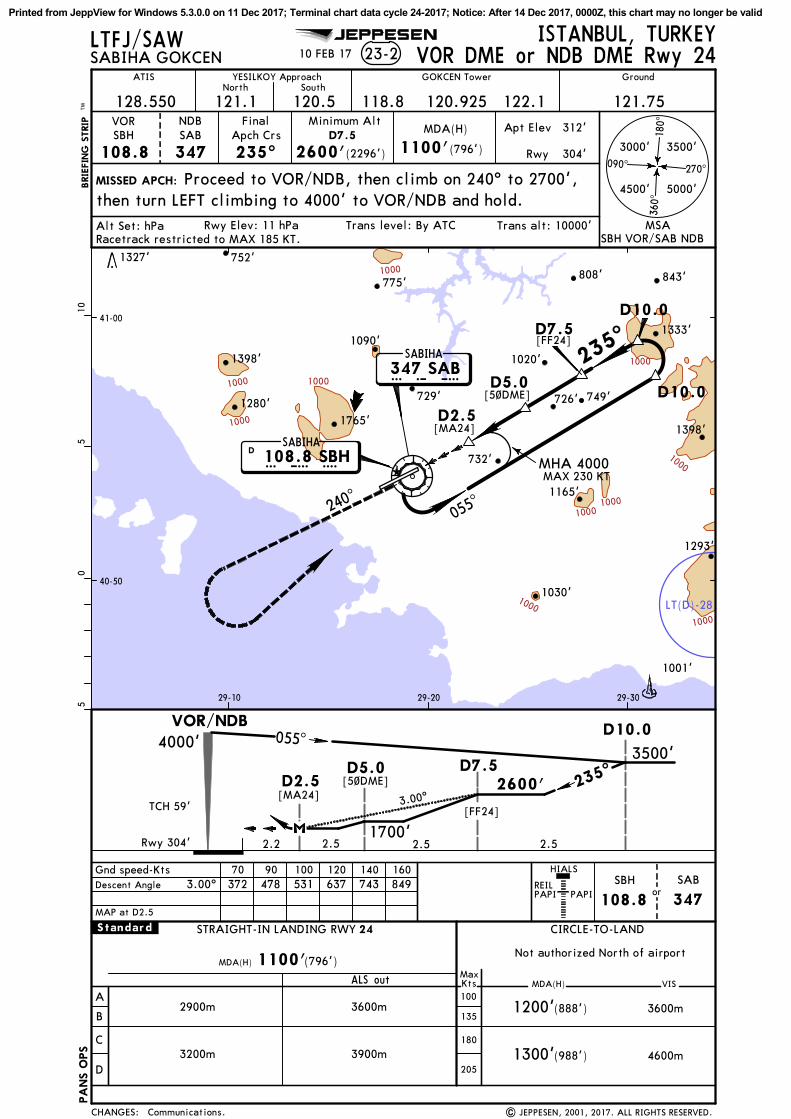
LT(D)-28
1000
1000
1000
1000
1000
1000
1000
10001000
1000
D10.0
D10.0
055^
235^
240^
40-50
41-00
29-10 29-20 29-30
ISTANBUL, TURKEY
BRIE
FIN
G S
TRIP
TM
SABIHA GOKCEN 23-2
VOR
108.8SBH
FinalApch Crs
235^
MDA(H)
(796')
Apt Elev 312'
Rwy 304'
MISSED APCH:
Trans level: By ATCRwy Elev: 11 hPa
1100'
1200'
1300'
24
(888')
(988')
1100'
A
B
C
D
CIRCLE-TO-LANDSTRAIGHT-IN LANDING RWY
ALS out MDA(H)MaxKts100
135
180
205
VIS
3600m
4600m
MDA(H)Not authorized North of airport
Minimum AltD7.5
2600'(2296')
MAP at D2.5
05
510
SABIHA108.8 SBHD
HIALS
PAPI PAPI
LTFJ/SAWVOR DME or NDB DME Rwy 24
NDBSAB
347
Proceed to VOR/NDB, then climb on 240^ to 2700',then turn LEFT climbing to 4000' to VOR/NDB and hold.
SABIHA347 SABS A B
SBH
108.8or
SAB
347
3000'
5000'
3500'
4500'
REIL
MSASBH VOR/SAB NDB
Trans alt: 10000'
| JEPPESEN, 2001, 2017. ALL RIGHTS RESERVED.
JEPPESEN
122.1North
121.1 120.5South
YESILKOY Approach
121.75118.8
GroundATIS
Alt Set: hPaRacetrack restricted to MAX 185 KT.
Gnd speed-Kts 70 90 100 120 140 160Descent Angle 372 478 531 637 743 8493.00^
[MA24]
.Standard.
2900m
GOKCEN Tower
270^090^
180^
360^
10 FEB 17
MAX 230 KTMHA 4000
(796')
3600m
3900m3200m
1280'
1398'
732'
1030'
1398'
726'
808'
1165'
1333'
729'
1020'
749'
1293'
775'
1765'
752'
1090'
1001'
1327'
843'
[FF24]
[5~DME]
120.925
2.52.52.52.2
055^
235^
[MA24] 3.00^[FF24]
[5~DME]
TCH 59'
128.550
Communications.
S B H
D2.5
D5.0
CHANGES:
PA
NS O
PS
D7.5
4000'
2600'
1700'
D2.5D5.0
D10.0
D7.53500'
VOR/NDB
Rwy 304'
Printed from JeppView for Windows 5.3.0.0 on 11 Dec 2017; Terminal chart data cycle 24-2017; Notice: After 14 Dec 2017, 0000Z, this chart may no longer be valid
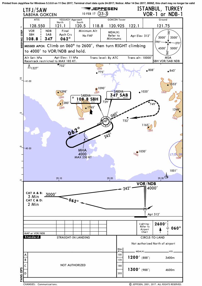
LT(D)-281000
1000
1000
1000
1000
1000
1000
1000
1000
1000
MHA4000
060^
062^242
^
40-50
41-00
29-10 29-20 29-30
3000'
5000'
3500'
ISTANBUL, TURKEY
BRIE
FIN
G S
TRIP
TM
SABIHA GOKCEN 23-3
4500'
VOR
108.8SBH
FinalApch Crs
062^
2600'on
4000'
1200'
1300'
(888')
(988')
A
B
C
D
CIRCLE-TO-LAND
MDA(H)MaxKts100
135
180
205
VIS
3400m
4600m
Not authorized North of airport
MISSED APCH:
Trans level: By ATCApt Elev: 11 hPa
312'Apt ElevMDA(H)Minimum Alt
No FAF
STRAIGHT-IN LANDING
NOT AUTHORIZED
242^
062^
3000'
Refer toMinimums
05
510
SABIHA108.8 SBHD S B H
Chart
Refer toAirport
Lighting -
LTFJ/SAWVOR-1 or NDB-1
Climb on 060^ to 2600', then turn RIGHT climbingto 4000' to VOR/NDB and hold.
NDBSAB
347
SABIHA347 SABS A B
VOR/NDB
060^MAP at VOR/NDB
MSASBH VOR/SAB NDB
Trans alt: 10000'
| JEPPESEN, 2001, 2017. ALL RIGHTS RESERVED.
JEPPESEN
122.1North
121.1 120.5South
YESILKOY Approach
121.75118.8
GroundATIS
Alt Set: hPaRacetrack restricted to MAX 185 KT.
.Standard.
GOKCEN Tower
10 FEB 17
270^090^
180^
360^
MAX 230 KT
1280'
1398'
732'
1030'
1398'
808'
1165'
1333'
729'
1020'
749'
775'
1765'
752'
1090'
1001'
1327'843'
120.925128.550
Communications.CHANGES:
CAT A & B:
3 Min
2 MinCAT C & D:
PA
NS O
PS
Apt 312'
Printed from JeppView for Windows 5.3.0.0 on 11 Dec 2017; Terminal chart data cycle 24-2017; Notice: After 14 Dec 2017, 0000Z, this chart may no longer be valid

LT(D)-281000
10001000
1000
1000
1000
1000
1000
1000
1000
1000
MHA4000
235^
055^240
^
40-50
41-00
29-10 29-20 29-30
3000'
5000'
3500'
ISTANBUL, TURKEY
BRIE
FIN
G S
TRIP
TM
SABIHA GOKCEN 23-4
4500'
VOR
108.8SBH
FinalApch Crs
235^
2700'on
2100'
A
B
C
D
CIRCLE-TO-LAND
MDA(H)MaxKts100
135
180
205
VIS
5000m
Not authorized North of airport
MISSED APCH:
Trans level: By ATCApt Elev: 11 hPa
312'Apt ElevMDA(H)Minimum Alt
No FAF
STRAIGHT-IN LANDING
NOT AUTHORIZED (1788')
4000' 055^
235^
3500'
2100'(1788')
CAT A & B:
3 Min
2 MinCAT C & D:
05
510
Chart
Refer toAirport
Lighting -
4000' to VOR/NDB and hold.
LTFJ/SAWVOR-2 or NDB-2
NDBSAB
347
Climb on 240^ to 2700', then turn LEFT climbing to
SABIHA347 SABS A B
VOR/NDB
MAP at VOR/NDB
240^
MSASBH VOR/SAB NDB
SABIHA108.8 SBHD S B H
Trans alt: 10000'
| JEPPESEN, 2001, 2017. ALL RIGHTS RESERVED.
JEPPESEN
122.1North
121.1 120.5South
YESILKOY Approach
121.75118.8
GroundATIS
Alt Set: hPaRacetrack restricted to MAX 185 KT.
.Standard.
GOKCEN Tower
10 FEB 17
270^090^
180^
360^
1280'
1398'
732'
1030'
1398'726'
808'
1165'
1333'
729'
1020'
749'
775'
1765'
752'
1090'
1001'
1327'843'
120.925
MAX 230 KT
128.550
Communications.CHANGES:
Apt 312'
PA
NS O
PS
Printed from JeppView for Windows 5.3.0.0 on 11 Dec 2017; Terminal chart data cycle 24-2017; Notice: After 14 Dec 2017, 0000Z, this chart may no longer be valid