Embed Size (px)
Citation preview
MATERIAL CHANGE OF USE – TRANSPORT DEPOT 42-46 LEN SHIELD STREET, PAGET
DEVELOPMENT ASSESSMENT REPORT
MATERIAL CHANGE OF USE Transport Depot (Bus Depot)
Lot 594 on CI4483 42-46 Len Shield Street, Paget Prepared for: Premier Illawarra Pty Ltd Prepared by: CARDNO HRP PLANNING CONSULTANTS Date: June 2012 Reference: 12NQ103Revision: 0
Cardno Humphreys Reynolds Perkins Jewell Pty Ltd
Level 2 56 Gordon Street Mackay QLD 4740 Australia
PO Box 244 Mackay QLD 4740 Australia Phone: +61 7 4953 2877 Fax: +61 7 4953 2577 www.cardno.com www.hrppc.com.au

Cardno HRP JUNE 2012 – 12NQ103 P a g e | i
MATERIAL CHANGE OF USE – TRANSPORT DEPOT 42-46 LEN SHIELD STREET, PAGET
Rev Prepared By Date Checked by Date Released by Date
0 Rachel Daniels 31.05.2012 Kate Swepson 01.06.2012 John Viklund 14.06.2012
Cardno HRP Planning Consultants retains ownership and copyright of the contents of this document including drawings, plans, figures and other work produced by Cardno HRP Planning Consultants. This document is not to be reproduced in full or in part, unless separately approved by Cardno HRP Planning Consultants. The client may use this document only for the purpose for which it was prepared. No third party is entitled to use or rely on this document. This report is based on our opinion of the town planning issues that arise from the statutory provisions relating to this site. Comments and conclusions in or construed from this report relating to matters of law are not to be relied upon. You should only rely upon the advice of your professional legal advisors with respect to matters of law. This report is provided on the basis that our standard Terms and Conditions apply. For a copy, please contact us or visit www.hrppc.com.au/CompanyTerms. Our report is based on information made available by the client. The validity and comprehensiveness of supplied information has not been independently verified and, for the purposes of this report, it is assumed that the information provided to Cardno HRP is both complete and accurate. Whilst, to the best of our knowledge, the information contained in this report is accurate at the date of issue, changes may occur to the site conditions, the site context or the applicable planning framework. This report should not be used after any such changes without consulting the provider of the report or a suitably qualified person.
Cardno HRP JUNE 2012 – 12NQ103 P a g e | ii
Contents
1. Application Summary ________________________________ iv 1.1. Development Application – Common Material ___________________________ v 1.2. Resource Allocation_______________________________________________ 1
2. Introduction ________________________________________ 2 3. Site Characteristics __________________________________ 3
3.1. Site Details Summary _____________________________________________ 3 3.2. Site Context _____________________________________________________ 3
3.2.1. Location __________________________________________________ 3 3.2.2. Ownership ________________________________________________ 3 3.2.3. Easements ________________________________________________ 3 3.2.4. Site Land Use ______________________________________________ 3 3.2.5. Road and Site Access ________________________________________ 3 3.2.6. Site Area and Shape _________________________________________ 4 3.2.7. Surrounding Land Use and Zoning ________________________________ 4 3.2.8. Existing Significant Vegetation ___________________________________ 4 3.2.9. Topography _______________________________________________ 5 3.2.10. Waterways, Water Bodies and Watercourse Areas _____________________ 5 3.2.11 Flooding and Inundation _______________________________________ 5 3.2.12 Acid Sulfate Soils ___________________________________________ 5 3.2.13 Existing Infrastructure Services __________________________________ 6 3.2.14 Indigenous and European Cultural Heritage and Native Title ______________ 6
3.3 Site Contamination _______________________________________________ 6 4. Proposal ___________________________________________ 7
4.1. Proposal Overview _______________________________________________ 7 4.2. Built Form ______________________________________________________ 8
4.2.1. Access, Car Parking and External Traffic Impacts ______________________ 8 4.2.2. Services __________________________________________________ 8 4.2.3. Landscaping & Provision of Green Space ___________________________ 8 4.2.4. Noise Impacts ______________________________________________ 8 4.2.5. Stormwater Management ______________________________________ 9
5. Assessment _______________________________________ 10 5.1. Regional Plan __________________________________________________ 12 5.2. State Planning Regulatory Provisions ________________________________ 12 5.3. State Planning Policies ___________________________________________ 12
5.3.1. SPP4/10 Healthy Waters _____________________________________ 13 5.4. Mackay City Planning Scheme dated 19 December 2011 _________________ 14
5.4.1. Mackay Frame Locality Code __________________________________ 14 5.4.2. Industrial Code ____________________________________________ 14 5.4.3. Environment and Infrastructure Code _____________________________ 14 5.4.4. Development in the Vicinity of Mackay Airport Overlay Code _____________ 14
5.5. Adopted Infrastructure Charges Resolution ____________________________ 15 6. Summary and Recommendation ______________________ 16
Cardno HRP JUNE 2012 – 12NQ103 P a g e | iii
APPENDICES APPENDIX A – OWNER’S CONSENT, TRANSFER DOCUMENTS AND SETTLEMENT
STATEMENT APPENDIX B – PLAN OF DEVELOPMENT APPENDIX C – CURRENT TITLE SEARCH APPENDIX D – REGISTERED SURVEY PLAN AND SMARTMAP APPENDIX E – SEARCHES: CLR AND EMR APPENDIX F – STATEMENT OF COMPLIANCE APPENDIX G – VEGETATION MANAGEMENT ACT MAPS IDAS FORMS IDAS FORM 1 – APPLICATION DETAILS IDAS FROM 5 – MATERIAL CHANGE OF USE

PREMIER ILLAWARRA TRUST42-46 LEN SHIELD STREET, PAGET
AMENDED >
FILENAME >
JOB NO. >
SCALE >
SOURCE >
LOCATION MAP
12NQ103
1:5,000
GOOGLE MAPS: Image dated 23/5/12
DATE >
VERSION >
MAY 2012
N/A
1.0
FIGURE 11
Location MapSUBJECT SITE
LEGEND
100 150 200metres0 50
1:5,000N
FIGU
RE1111111
SUBJECT SITESUBJECT SITESUBJECT SITE
PREMIER ILLAWARRA TRUST42-46 LEN SHIELD STREET, PAGET
AMENDED >
FILENAME >
JOB NO. >
SCALE >
SOURCE >
ZONING MAP
12NQ103
1:5,000
MACKAY CITY COUNCIL PLANNING SCHEME: ZONE MAP:
SERIES 24 - PAGET: 6/11/10
DATE >
VERSION >
MAY 2012
N/A
1.0
FIGURE 22
Zoning MapSUBJECT SITE
INDUSTRY - HIGH IMPACT
PUBLIC PURPOSE
OPEN SPACE
LEGEND
100 150 200metres0 50
1:5,000N
FIGU
RE2222222
SUBJECT SITESUBJECT SITESUBJECT SITE
Cardno HRP JUNE 2012 – 12NQ103 P a g e | iv
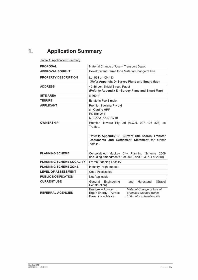
1. Application Summary Table 1: Application Summary
PROPOSAL Material Change of Use – Transport Depot APPROVAL SOUGHT Development Permit for a Material Change of Use
PROPERTY DESCRIPTION Lot 594 on CI4483 (Refer Appendix D–Survey Plans and Smart Map)
ADDRESS 42-46 Len Shield Street, Paget (Refer to Appendix D –Survey Plans and Smart Map)
SITE AREA 6,460m2 TENURE Estate in Fee Simple APPLICANT Premier Illawarra Pty Ltd
c/- Cardno HRP PO Box 244 MACKAY QLD 4740
OWNERSHIP Premier Illawarra Pty Ltd (A.C.N. 097 103 323) as Trustee.
Refer to Appendix C – Current Title Search, Transfer Documents and Settlement Statement for further details.
PLANNING SCHEME Consolidated Mackay City Planning Scheme 2009 (including amendments 1 of 2009, and 1, 3, & 4 of 2010)
PLANNING SCHEME LOCALITY Frame Planning Locality PLANNING SCHEME ZONE Industry (High Impact) LEVEL OF ASSESSMENT Code Assessable PUBLIC NOTIFICATION Not Applicable CURRENT USE General Engineering and Hardstand (Gravel
Construction)
REFERRAL AGENCIES Energex – Advice Ergon Energy – Advice Powerlink – Advice
Material Change of Use of premises situated within 100m of a substation site

Cardno HRP JUNE 2012 – 12NQ103 P a g e | v
1.1. Development Application – Common Material The following documents comprise the common material1 of this application:
� IDAS Form 1: Application Details;
� IDAS Form 5: Material Change of Use;
� Owners Consent, executed by the owners of the land
Further, the common material of the application comprises of the following “mandatory supporting information” which constitutes a ‘properly made application’ for a Material Change of Use under section 261 of the Sustainable Planning Act 2009 (SPA):
� A statement (being the Proposal Report and accompanying documents) about how the proposed development addresses the local government’s planning schemes and any other planning documents relevant to the application.
� A site plan which shows the following
Table 2: Mandatory Plan of Development Information
MANDATORY REQUIREMENT SHOWN
the location and site area of the land to which the application relates (relevant land); �
the north point; �
the boundaries of the relevant land; �
any road frontages of the relevant land, including the name of the road; �
the location and use of any existing or proposed structures on the relevant land (note: where
extensive demolition or new buildings are proposed, two separate plans (an existing site plan
and proposed site plan) may be appropriate);
�
any existing or proposed easements on the relevant land and their function; N/A
the location and use of buildings on land adjoining the relevant land; �
all vehicle access points and any existing or proposed car parking areas on the relevant
land. Car parking spaces for persons with disabilities and any service vehicle access and
parking should be clearly marked;
�
for any new building on the relevant land, the location of refuse storage; N/A
the location of any proposed retaining walls on the relevant land and their height; N/A
the location of any proposed landscaping on the relevant land; �
the location of any stormwater detention on the relevant land; �
1 At the time of lodging the development application, the common material comprises the application material only. This
Proposal Report forms part of the common material used to assess the development proposal. It accompanies duly executed IDAS application forms and plans of development.
As the assessment of the application progresses under the IDAS, additional information which arises from the subsequent information and referral stages, will also form part of the common material which will be considered by the assessment manager in the assessment of the application.

Cardno HRP JUNE 2012 – 12NQ103 P a g e | 1
1.2. Resource Allocation Where a proposed development will interfere with a State resource as defined under Schedule 14 of the Sustainable Planning Regulation 2009 (SP Reg), evidence of a resource allocation is needed to support the application
There is no requirement for resource allocation for the development.

Cardno HRP JUNE 2012 – 12NQ103 P a g e | 2
2. Introduction Cardno HRP has been commissioned by Premier Illawarra Pty Ltd (A.C.N. 097 103 323) (“the applicant”) to prepare and lodge an application for a development permit for a Material Change of Use – Transport Depot on premises located at 42-46 Len Shield Street, Paget, properly described as Lot 594 on CI4483. A Location Map is included in Figure 1.
The application comprises of the following elements:
� Material Change of Use – Transport Depot.
Under the applicable planning scheme (Consolidated Mackay City Planning Scheme 2009 (including amendments 1 of 2009, and 1, 3, & 4 of 2010)), the subject site is located within the Mackay Frame Locality, and is included within the Industry (High Impact) zone. Under the Mackay City Planning Scheme, an application for a Transport Depot is Code Assessable development within the Industry (High Impact) Zone. Section 313 of the Sustainable Planning Act 2009 (“the SPA”) prescribes the requirements for Code Assessment generally.
Accordingly, the applicant is seeking a Development Permit for a Material Change of Use to undertake the proposed development.
This Development Assessment Report has been prepared as supporting material to accompany the application for a Material Change of Use.

Cardno HRP JUNE 2012 – 12NQ103 P a g e | 3
3. Site Characteristics 3.1. Site Details Summary
The table below provides a summary of the details applying to the subject site.
Table 3: Site Details Summary.
STREET ADDRESS 42-46 Len Shield Street, Paget REAL PROPERTY DESCRIPTION Lot 594 on CI4483 SITE AREA 6,460m2 LOCAL AUTHORITY AREA Mackay Regional Council
3.2. Site Context 3.2.1. Location
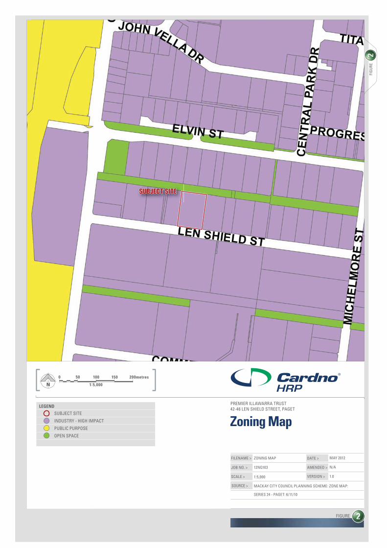
The subject site is located within the Industry (High Impact) zone in the Pioneer River (Urban) Planning Precinct, within the Frame Locality. A Location Map is included in Figure 1.
The locality is characterised by large industrial buildings, workshops and offices. Allotments within the locality are generally larger in area to accommodate such uses.
Appendix D – Registered Survey Plan & Smart Map to this report provides information on the registered survey plan.
3.2.2. Ownership
The registered owner of the allotment properly described as Lot 594 on CI4483 is Premier Illawarra Pty Ltd (A.C.N. 097 103 323) as Trustee. Refer to Appendix C – Current Title Search, Transfer Documents and Settlement Statement for further details.
3.2.3. Easements
The site is not encumbered by any easement.
Refer to Appendix C – Current Title Search for details.
3.2.4. Site Land Use
The subject lot currently maintains an existing industrial shed, including office space, and is used for general engineering. The external hardstand area is predominately of gravel construction, with both gravel and paved car parking areas located along the site frontage.
3.2.5. Road and Site Access
The subject site has three (3) access points to Len Shield Street along the southern boundary of the lot. Kerb and channel is provided for the full site frontage.

Cardno HRP JUNE 2012 – 12NQ103 P a g e | 4
3.2.6. Site Area and Shape
The subject site is rectangular in shape with an approximate frontage of 70m to Len Shield Street. The lot is 6,460m2 in area.
3.2.7. Surrounding Land Use and Zoning
Table 4 below outlines the various land uses and zones of the properties surrounding the subject lot.
Table 4: Surrounding Land Uses and Zoning
Direction Zoning Land Use North Open Space Drain – Bakers Creek South Mackay
Main Drain
South Industry (High Impact) Industrial land use – General Industry – Workshop/Shed
East Industry (High Impact) Industrial land use – General Industry - Workshop/Shed
West Industry (High Impact) Industrial land use – General Industry - Workshop/Shed
Figure 3: Surrounding Land Uses (Mackay Regional Council, Mimaps)
3.2.8. Existing Significant Vegetation
The site has previously been cleared and is devoid of vegetation. The site is not mapped as containing any remnant or regrowth vegetation Refer to Appendix G – Vegetation Management Act Maps for details.
Subject Site

Cardno HRP JUNE 2012 – 12NQ103 P a g e | 5
3.2.9. Topography
The site has a minimal fall from the Len Shield Street frontage to the rear of the site from approximately RL6.25m AHD to RL6m AHD.
Figure 4: Site Topography (Mackay Regional Council, Mimaps)
3.2.10. Waterways, Water Bodies and Watercourse Areas The site is not within the trigger area of any referable wetland (refer to Appendix G). The subject site is not mapped on Council’s MiMaps as within the wetlands or buffer area.
3.2.11 Flooding and Inundation
The subject site is not identified as being subject to flooding and inundation as per Council mapping.
3.2.12 Acid Sulfate Soils
The subject site is not identified as being subject to Acid Sulfate Soils as per Council mapping.

Cardno HRP JUNE 2012 – 12NQ103 P a g e | 6
3.2.13 Existing Infrastructure Services Table 5 below provides a description of the location of the existing services.
Table 5 – Existing service location
Water Reticulated service available. An underground water main is present along the Len Shield Street frontage, located in the road reserve.
Sewerage Reticulated service available. A sewer main is present along the Len Shield Street frontage, located within the subject site.
Stormwater Existing stormwater infrastructure is located on-site, with drainage towards the Bakers Creek South Mackay Main Drain to the north of the site.
Electricity Electricity is available in the locality.
Access Kerb and channel is provided for the full site frontage to Len Shield Street is provided.
Roads Len Shield Street – constructed and sealed with barrier kerb and channelling for full site frontage.
3.2.14 Indigenous and European Cultural Heritage and Native Title The Applicant is aware of the duty of care responsibilities under the Aboriginal Cultural Heritage Act 2003, in the event that aboriginal cultural heritage is encountered during site development activities. It is considered that the risk of an indigenous cultural heritage find is relatively low given the extent of prior site disturbance.
Pursuant to the Native Title Act 1994 Part 2 Section 8, as the lot has been under freehold title since before 1 January 1994 native title rights have been extinguished in respect of the site.
3.3 Site Contamination A search of the Environmental Management Register (EMR) and Contaminated Land Register (CLR) was undertaken on 29 May 2012. This search has confirmed that no part of the subject site is included on the EMR or CLR (refer to Appendix E – Searches CLR & EMR).
3.4 Bushfire Impact and Prevention The site is not mapped as having a bushfire hazard present as per Council mapping.

Cardno HRP JUNE 2012 – 12NQ103 P a g e | 7
4. Proposal 4.1. Proposal Overview
The applicant proposes to establish a Transport Depot at the site, being for the parking and storage of buses. The proposed Transport Depot involves reuse of the existing shed (building height approximately 11m) and office building. An ERA application for mechanical repairs and maintenance will be lodged subsequently if required. There will be minimal oil stored on-site, purely for minor maintenance on buses only.
Car parking for employees is available at the front of the subject site. There will be no visitors to the subject site as the development is for the storage or buses only.
The existing on-site landscaping will not be altered as a result of this application. Current landscaping is located at the centre of the Len Shield Street frontage and along the western boundary (near the car parking area).
The site currently contains a demountable office and igloo structure that will be removed from site prior to commencement of use (refer to Figure 5).
Figure 5: Existing structures and stormwater management
For further detail refer to Appendix B – Plan of Development.
It is noted that the development does not propose to alter the existing permanent buildings, car parking, landscaping, infrastructure and services on the site.

Cardno HRP JUNE 2012 – 12NQ103 P a g e | 8
Staff
There will be 15 employees on-site as a result of the proposed development. As the site is to be used for storage of buses only, there will be no vistors to the Transport Depot.
Hours of Operation
The hours of operation for the Transport Depot will typically be 6am – 6pm, 7 days a week.
4.2. Built Form The subject site currently maintains a large industrial shed (approximately 28m x 62m x 11m), a small office building (approximately 15m x 6.5m) (refer to figure 6) and two (2) temporary structures, these being a demountable office extension and igloo workshop structure. The two (2) temporary structures will be removed off-site prior to the commencement of use.
Figure 6: Western elevation of existing building No changes are proposed to the existing built form, described as a colourbond sheeting industrial shed with a besser brick office with glass sliding doors. These structures maintain appropriate setback distances from front, side and rear boundaries.
4.2.1. Access, Car Parking and External Traffic Impacts
The site will maintain the existing accesses to Len Shield Street. The site currently has 15 on-site car parks, also to be maintained. There will be no visitors to the Transport Depot as the use is for the storage of buses only.
4.2.2. Services
The site is connected to all necessary infrastructure including water, sewerage, electricity and telecommunications. No change to existing service arrangements is proposed.
4.2.3. Landscaping & Provision of Green Space
As shown in the Proposal Plan, the existing on-site landscaping and open space will be retained.
For further detail refer to Appendix B – Plans of Development.
4.2.4. Noise Impacts
The proposed development for an industrial use is a consistent use in the Industry (High Impact) zone. The proposed development will not create noise impacts that are not already present in the locality. No noise-sensitive uses have been identified in the locality.

Cardno HRP JUNE 2012 – 12NQ103 P a g e | 9
4.2.5. Stormwater Management
Stormwater runoff is maintained through an existing stormwater drainage system which discharges into the Bakers Creek South Mackay Main Drain. Four large drain inlets are located either side of the existing shed (8 drain inlets in total).
An underground pipe network directs stormwater collected on-site to three (3) headwalls located in the Bakers Creek South Mackay Main Drain being the legal point of discharge.
For further detail refer to Appendix B – Plan of Development
The existing stormwater system is proposed for retention as part of the application.

Cardno HRP JUNE 2012 – 12NQ103 P a g e | 10
5. Assessment This application is submitted and assessable in accordance with the Sustainable Planning Act 2009 Reprint No.2 as in force on 2 March 2012 (SPA) and the Sustainable Planning Regulation 2009 Reprint No.3 as in force on 17 February 2012 (SPReg). Section 313 of SPA sets out the matters or things which the assessment manager must assess to the extent it is relevant to the proposal.
Table 7 provides a summary of the relevant matters for assessment.
Table 7 Summary of relevant matters for assessment
(a) The State Planning Regulatory Provisions Region: Mackay, Isaac and Whitsunday (MIW) Regulatory Provisions: MIW State Planning Regulatory Provisions (b) the regional plan for a designated region, to the extent it is not identified in the planning scheme as being appropriately reflected in the planning scheme MIW Regional Plan Status: Statutory Reflected in the Scheme: No Land Use Designation: Urban Footprint (c) any applicable codes, other than concurrence agency codes the assessment manager does not apply, that are identified as a code for IDAS under this or another Act
Applicable codes: Nil (d) State planning policies, to the extent the policies are not identified in— (i) any relevant regional plan as being appropriately reflected in the regional plan; or (ii) the planning scheme as being appropriately reflected in the planning scheme;
State Planning Policy Reflected in the Scheme: Applicable:
SPP 1/02 Development in the Vicinity of Certain Airports and Aviation Facilities 1.0 YES NO*1
SPP 2/02 Planning and Managing Development Involving Acid sulphate Soils 1.0
YES NO*2
SPP 1/03 Mitigating the Adverse Impacts of Flood, Bushfire and Landslide 1.0 YES NO*3
SPP 1/07 Housing and Residential Development 1.0 NO NO*4 SPP 2/07 Protection of Extractive Resources and Guideline YES NO*5
SPP 4/11 Protecting Wetlands of high Ecological Significance in Great Barrier Reef Catchments
NO NO*6
SPP 2/10 South East Queensland Koala Conservation NO NO*7
SPP 3/10 Acceleration of Compliance Assessment NO NO*8 SPP 4/10 Healthy Waters NO YES
SPP 5/10 Air, Noise and Hazardous Materials NO NO*9
Temporary SPP 2/11 Planning for Stronger, More NO NO*10

Cardno HRP JUNE 2012 – 12NQ103 P a g e | 11
Resilient Floodplains. SPP 1/92 Development and the Conservation of Agricultural Land 1.0
YES NO*11
SPP 3/11 Coastal Protection NO NO*12 SPP 1/12 Protection of Queensland’s Strategic Cropping Land NO NO*13
*1 The effect of the policy is to be appropriately reflected in the planning scheme and does not contain assessment provisions applicable to this development application. *2 The site is not affected by acid sulfate soils. *3 The effect of the policy is to be appropriately reflected in the planning scheme and does not contain assessment provisions applicable to this development application. *4 The effect of the policy is to be appropriately reflected in the planning scheme and does not contain assessment provisions applicable to development applications. *5 No part of the site is within a mapped Key Resource Area. *6 The site is not located within the barrier reef catchment. *7 The development is not in the SEQ Region. *8 The application is not for compliance assessment. *9 The proposed development is not located within an identified Management Area. *10 The proposed development is not located in a flood plain. *11 The site is not identified as being Good Quality Agricultural Land *12 The land is not identified within the Coastal Management District and not subject to Coastal Hazards *13 The policy does not apply as the site is outside of a Strategic Cropping Land zone. (e) any applicable codes in the following instruments— (i) a structure plan; (ii) a master plan; (iii) a temporary local planning instrument; (iv) a preliminary approval to which section 242 applies; (v) a planning scheme;
N/A N/A N/A N/A Refer below
Mackay City Planning Scheme Locality: Mackay Frame Precinct: Pioneer River (Urban) Zone: Industry (High Impact) Road Hierarchy: Len Shield Street – Minor Collector
Planning Scheme Overlays: Airport Obstacle Limitation Surface Airport Development Distances
Type of Development: Material Change of Use Application process: Code Assessment
Relevant Assessment Criteria: Locality Code (Frame) Environment and Infrastructure Code Industrial Code Development in the Vicinity of Mackay Airport Overlay Code

Cardno HRP JUNE 2012 – 12NQ103 P a g e | 12
5.1. Regional Plan
The assessment manager must assess the application against the regional plan for the region, to the extent it is not identified in the planning scheme as being appropriately reflected in the planning scheme.
The regional plan which the subject sites are located in is the Mackay, Isaac and Whitsunday Regional Plan released by the Queensland State Government on 8 February 2012. The regional plan is accompanied by the Mackay, Isaac and Whitsunday State Planning Regulatory Provisions. The subject area is identified in Urban Footprint on Map 2 “Regional Land Use Categories” of the MIW Regional Plan. The MIW Regional Plan identifies that local government planning schemes are the main instrument that will establish and refine the desired use of land and the preferred timing of development. An assessment of the development against the Mackay City Planning Scheme dated 19 December 2011 can be found below.
5.2. State Planning Regulatory Provisions
A State planning regulatory provision is a statutory planning instrument made under SPA to advance the purpose of SPA by—
(a) providing regulatory support for regional planning or master planning; or (b) providing for a charge for the supply of infrastructure; or (c) protecting planning scheme areas from adverse impacts.
The Mackay, Isaac and Whitsunday State Planning Regulatory Provisions have been implemented for the Mackay Whitsunday region. The MIW regulatory provisions only apply to development in the Urban Footprint, if the land is included within a ‘Development Area’. The MIW SPRP is not applicable to this development as it is within the Urban Footprint, but not within a Development Area.
5.3. State Planning Policies A State planning policy is an instrument made under SPA which advances the purpose of the Act by stating the State’s policy about a matter of State interest. State Planning Policies which have been identified in the planning scheme as being appropriately reflected in the planning scheme do not require further assessment pursuant to an IDAS application. With regards to the remaining State planning policies which have not been identified as being appropriately reflected in the planning scheme, SPP 4/10 Healthy Waters is relevant to the proposal. An assessment of the proposal against SPP4/10 is provided below.

Cardno HRP JUNE 2012 – 12NQ103 P a g e | 13
5.3.1. SPP4/10 Healthy Waters
The proposed development is for a material change of use for urban purposes that involved an area greater than 2,500m2 and involves waste water discharge. Therefore the proposal is required to address Appendix 1 – Development Assessment Code of the State Planning Policy (SPP) 4/10 – Healthy Waters.
Purpose of Code:
a. avoids and minimises development impacts arising from altered stormwater quality and flow by providing for development and construction activities in accordance with acceptable design objectives (Part A of the code); and
Response:
The subject site currently maintains an existing stormwater drainage system which discharges into the Bakers Creek South Mackay Main Drain. Four large drain inlets are located either side of the existing shed (8 drain inlets in total).
An underground pipe network directs stormwater collected on-site to three (3) headwalls located in the Bakers Creek South Mackay Main Drain being the legal point of discharge.
The existing built form and infrastructure will not be altered, and therefore there will be no construction as part of the development. It is considered that the development achieves Part A of the code.
b. avoids and minimises development impacts of waste water other than contaminated stormwater (Part B of the code); and
Response:
The development is for a Transport Depot which will involve the storage of buses on-site only. Chemicals or potential water contaminates will not be stored on-site, expect for minor quantities of oil.
The existing industrial shed prevents the intrusion of stormwater to the bus storage area. Water quality will not be detrimentally impacted upon as a result of the development.
It is considered that the development achieves Part B of the code.
c. avoids and minimises development impacts arising from the creation or expansion of non-tidal artificial waterways such as urban lakes (Part C of the code).
Response:
The development does not include the creation or expansion of non-tidal artificial waterways.
It is considered that the development is not applicable to Part C of the code.
Assessment of the purpose and overall outcomes of Appendix 1 – Development Code of the State Planning Policy (SPP) 4/10 – Healthy Waters demonstrates that the proposed development achieves compliance with the requirements of SPP 4/10 – Healthy Waters.
Cardno HRP JUNE 2012 – 12NQ103 P a g e | 14
5.4. Mackay City Planning Scheme A comprehensive assessment of the development’s compliance with the relevant codes of the Consolidated Mackay City Planning Scheme 2009 (including amendments 1 of 2009, and 1, 3, & 4 of 2010) is included as Appendix F – Statement of Compliance of this Development Assessment Report. Compliance with the codes is summarised below.
5.4.1. Mackay Frame Locality Code
Development that is consistent with the specific outcomes for the locality and the relevant zone complies with the Mackay Frame Locality Code.
A detailed statement about compliance with each of the relevant specific outcomes in the Mackay Frame Locality Code and Industrial Zone is provided in Appendix F.
In summary, the development is consistent with each of the relevant Specific Outcomes in the code and is therefore consistent with the Code.
5.4.2. Industrial Code
For assessable development, compliance with the Industrial Code is achieved when development is consistent with the specific outcomes of the Code.
A detailed statement about compliance with each of the relevant specific outcomes in the Industrial Code is provided in Appendix F.
The proposal complies with each of the Specific Outcomes of the Industrial Code and therefore complies with the Code.
5.4.3. Environment and Infrastructure Code
For assessable development, compliance with the Environment and Infrastructure Code is achieved when development is consistent with the specific outcomes of the code.
A detailed statement about compliance with each of the relevant specific outcomes in the Environment and Infrastructure Code is provided in Appendix F.
The proposal complies with each of the Specific Outcomes of the Environment and
Infrastructure Code, and therefore complies with the Code.
It is noted that S11.1 of the code outlines “Vehicle parking on the site is in accordance with the rates specified in Schedule 2”. Existing car parking on the sites provides for 15 car parking spaces. As the development is for a Transport Depot (storage of buses only), there will be no visitors to the use. Therefore, it is considered that the existing car parking provisions on the subject site are appropriate in this instance.
5.4.4. Development in the Vicinity of Mackay Airport Overlay Code
The site is located approximately 2km from the Mackay Airport runway and is outside the 49m ANEF contour and outside the aviation facilities buffer. The proposal is not for a use triggering code or impact assessment in “Table 8-7 Assessment Categories and Relevant Assessment Criteria for Development in the Vicinity of Mackay Airport Overlay – Making a Material Change of Use” and is therefore exempt from assessment against the Code.

Cardno HRP JUNE 2012 – 12NQ103 P a g e | 15
5.5. Adopted Infrastructure Charges Resolution In accordance with Council’s adopted infrastructure charges resolution (AICR) (effective from 5 December 2011), Council infrastructure charges are applicable to any development approval for Material Change of Use. It is further outlined within Council’s AICR that credits apply to the site with an existing lawful use at the time the development application is made (Mackay Regional Council, 2011). The existing use on the subject site is for General engineering, defined as “General Industry” in accordance with the Consolidated Mackay City Planning Scheme 2009. The proposed use for the subject site is a “Transport Depot”. Council’s AICR outlines the following Planning scheme uses types:
(Mackay Regional Council, 2011)
In accordance with the AICR, applicable charges for High Impact Industry (existing use) and Industry (proposed use) are as follows:
High Impact Industry
Charge 1 (water, sewerage, transport, parks) $70 per m2 of GFA Charge 2 (stormwater) $10 per m2 of impervious area (including total hard stand area). Industry
Charge 1 (water, sewerage, transport, parks) $50 per m2 of GFA Charge 2 (stormwater) $10 per m2 of impervious area (including total hard stand area).
As there is a reduction of load on municipal infrastructure demand from High Impact Industry (General Industry) to Industry (Transport Depot), the value of existing credits is greater than the charge for the proposed use.

Cardno HRP JUNE 2012 – 12NQ103 P a g e | 16
6. Summary and Recommendation This Development Assessment Report accompanies an application for a Development Permit for a Material Change of Use for a Transport Depot at 42-46 Len Shield Street, Paget, properly described as Lot 594 on CI4483.
This Development Assessment Report (and supporting application material) demonstrates that the proposed development complies with the Consolidated Mackay City Planning Scheme 2009 (including amendments 1 of 2009, and 1, 3, & 4 of 2010).
In particular, the proposed development:
(i) Is for the reuse of an existing industrial shed in the Paget industrial area;
(ii) Is appropriately located within the Industry (High Impact) Zone;
(iii) Is consistent with the Consolidated Mackay City Planning Scheme 2009;
(iv) Is non-intrusive in nature and will not result in any increase in impacts to surrounding uses.
In conclusion, based upon the planning assessment of the proposed development against the provisions of the SPA, Regional Plan, relevant State Planning Policies and the Consolidated Mackay City Planning Scheme 2009; it is recommended that the Mackay Regional Council approves the development application, subject to reasonable and relevant conditions.
Yours faithfully
John Viklund Senior Planner for Cardno HRP