Embed Size (px)
Citation preview


1
Los Angeles/Gateway Freight Technology Program |LA Metro l
California Sustainable Freight Action Plan: Pilot Project Ideas Submitted by: the Los Angeles County Metropolitan Transportation Authority (Metro) In partnership with Caltrans, County of Los Angeles Department of Public Works, City of Los Angeles, Gateway Cities Council of Governments, Port of Long Beach, Port of Los Angeles, South Coast Air Quality Management District, and Southern California Association of Governments
1.0 Name and Contact information Steven Gota Ed Alegre Deputy Executive Officer Transportation Planning Manager One Gateway Plaza One Gateway Plaza Mail Stop: 99-22-9 Mail Stop: 99-22-9 Los Angeles, CA 90012 Los Angeles, CA 90012 (213) 922-3043 (213) 922-7902 [email protected] [email protected]
2.0 Descriptive project title Los Angeles/Gateway Freight Technology Program
3.0 Location of Project The project area is bounded by the Santa Monica Freeway (Interstate 10, or I-10) and Pomona Freeway (State Route 60, or SR-60) to the north, Interstate 605 (I-605) and the San Gabriel River to the east, Vermont Avenue to the west, and the Pacific Coast to the south. This area includes the following freight and goods movement facilities of significance: the Port of Los Angeles (POLA), the Port of Long Beach (POLB) and the Long Beach Freeway (Interstate 710, or I-710) from its southern terminus near the Port of Long Beach (CA post mile 4.96) to the City of Commerce rail-yards 18 miles to the north (CA post mile 23.19). The project boundaries encompass portions of the City of Los Angeles and the Gateway Cities Council of Governments (GCCOG) sub-region, as well as the following major arterials: Washington Boulevard, Bandini Boulevard, Slauson Avenue, Manchester Avenue/Firestone Boulevard, Del Amo Boulevard, Pacific Coast Highway (State Route 1, or SR-1), the Alameda Street Corridor, and Garfield Avenue/Cherry Avenue. A map of the overall project extents is shown below in Figure 1.

2
Los Angeles/Gateway Freight Technology Program |LA Metro l
Figure 1: Los Angeles/Gateway Freight Technology Program Area

3
Los Angeles/Gateway Freight Technology Program |LA Metro l
4.0 Executive Summary The Los Angeles County Metropolitan Transportation Authority (Metro) and its partners are pleased to submit this Los Angeles/Gateway Freight Technology Program (the “Program”) in response to the call for concepts associated with the Governor’s Sustainable Freight Action Plans. In southern Los Angeles County, the POLA and POLB (i.e., “the Ports”) collectively comprise the largest port complex in North America, handling 40% of the nation’s import traffic and 25% of the nation’s export traffic. These ports are supported by over half a billion square feet in warehousing space and serviced by 1,000 trucking and drayage companies. In 2013, California’s freight-dependent industries accounted for more than $700 billion in revenue and supported more than five million jobs, and in 2014, 15.2 million 20-foot equivalent units (TEUs) passed through the Ports. This volume of TEUs is expected to increase to 36 million by 2035. The Ports are located in the South Coast Air Basin, which includes portions of four Southern California counties (Los Angeles, Orange, San Bernardino, and Riverside) and is one of the state’s most significant nonattainment areas with air quality among the worst in the nation. The basin spans an area of 6,745 square miles with a population of over 16.5 million people, making its poor air quality a serious health concern to the state and the country; the Environmental Protection Agency (EPA) has already designated it a nonattainment area according to the National Ambient Air Quality Standards. The basin’s air quality issues are largely due to the fact that it is situated in the nation’s second-largest urban area, and has specific topographical attributes and meteorological conditions that increase the severity of airborne pollution when it occurs. The projected increase in truck traffic through the project area between now and 2035 presents an urgent, major challenge, as it has the potential to generate significant increases in congestion and to accelerate the deteriorating air quality conditions in the region. The region’s long-term economic viability and public health conditions will depend on the implementation of strategies that leverage technology to improve goods movement efficiencies, support emerging zero emissions vehicles while at the same time keeping California competitive.
Implementing strategies that leverage technology to make goods movement through the project area more efficient and to promote the use of zero-emissions vehicles are pivotal to the region’s long-term economic viability, the quality of life for its residents, and California’s continued competitiveness in the global economy. The Program (described below) is directly responsive to—and consistent with—major policy initiatives pursued by the State of California to reduced carbon emissions and promote the efficient movement of freight. The Program incorporates elements of several ongoing and recently completed planning efforts led by Metro, GCCOG, and POLA, with a focus on how advanced technology can be leveraged to improve freight efficiency, facilitate the adoption of zero-emission technologies, and increase the region’s competitiveness in the global economy. Contributing sources for the projects incorporated into the Program include: the I-710 Corridor reconstruction and improvement project study (i.e., the “I-710 Corridor Project” study), the GCCOG Technology Plan for Goods Movement, the GCCOG Strategic Transportation Plan, and California’s statewide connected vehicle pilot program (“One California”). The specific pilot projects included in the Program are:

4
Los Angeles/Gateway Freight Technology Program |LA Metro l
Connected Vehicle Technology
Arterial Smart Corridors
Freeway Smart Corridors
Freight Advanced Traveler Information System Expansion
Zero and Near-Zero Emissions Technology for Vehicles
Zero and Near-Zero Emissions Technology for Rail-yards
In addition to the above projects, POLA is also currently in the planning stage of an improvement project for its on-dock rail facilities. The I-710 Corridor Project, another large scale project anticipated for the future, comes with substantial costs and a protracted timeline; although it has not been included in the current Program in its entirety, some of its components have been incorporated into the Program as they can be realistically and effectively advanced today without waiting for the full I-710 Corridor Project implementation. The Program includes the deployment of a number of Intelligent Transportation Systems (ITS) and Connected Vehicle (CV) elements along several key regional corridors for goods movement (both freeway and arterials), and would facilitate the sharing of data and information across public and private stakeholders. The Program also offers a technology-based solution to the region’s current truck enforcement issues, and yields substantial air quality improvements that will universally benefit the health of all stakeholders in the area; for example, NOx reductions alone are estimated to be over 400 tons per year as a result of the Program. The timeliness and relevance of this Program is highlighted by the California State Transportation Agency (CalSTA) Secretary Brian Kelly in saying, “to improve California’s opportunities for global trade, the state must continue to push its freight transport system to be more efficient, reliable and environmentally friendly, while better serving its customers.” As a whole, this program represents an unparalleled opportunity for the State to transform some of its most important policy initiatives into impactful, real-world projects with tangible benefits to residents and industry.

5
Los Angeles/Gateway Freight Technology Program |LA Metro l
5.0 Detailed Description of Pilot Project
5.1 Program Context and Need Efficient goods movement through the Program area is pivotal to the quality of life for its residents and to the long-term economic health of its businesses. Residents benefit from improved air quality resulting from more efficient freight operations, while businesses benefit from lower costs associated with improved travel time reliability and on-time deliveries—savings that they can then pass on to consumers. Examples of current inefficiencies targeted by this Program include extended periods of truck idling and excessive trips by unloaded trucks or bobtails (i.e., trucks with no trailers attached).
Figure 2: Aerial view of the transloading facilities at POLB
In southern Los Angeles County, the POLA and POLB (visible in Figure 2) collectively comprise the largest port complex in North America, handling 40% of the nation’s import traffic and 25% of the nation’s export traffic and making this region one of the core freight facilities in the country. Figure 3 shows the Ports in the context of the region’s freight transportation infrastructure. The POLA alone handles approximately 19% of all US waterborne container traffic, making it the largest container seaport in North America. These ports are supported by over half a billion square feet in warehousing space and

6
Los Angeles/Gateway Freight Technology Program |LA Metro l
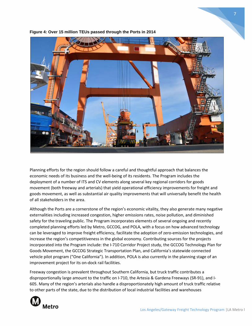
serviced by 1,000 trucking and drayage companies. In 2013, California’s freight-dependent industries accounted for more than $700 billion in revenue and supported more than five million jobs, and in 2014, 15.2 million TEUs passed through the Ports (Figure 4 shows a facility responsible for handling TEUs). This volume of TEUs is expected to increase by 236% to 36 million by 2035.
Figure 3: Regional freight context for the Ports and the Program area
The rail system serving the Ports is also instrumental in enabling the efficient transportation of goods through the region, as rail service can be highly economically and environmentally efficient compared to truck transportation. Approximately 35% of all containers are loaded onto trains, either at on-dock facilities (one out of every four containers) or off site rail-yards (three out of every four). The Ports have a policy of maximizing the use of on-dock rail facilities for container movements, and have subsequently made investments in rail infrastructure accordingly. To accommodate the forecasted growth in rail traffic through 2035, which is estimated to increase by 331% to 315 trains/per day, the Ports have developed a comprehensive $2 billion rail system improvement program to guide investments over the next 10-15 years.
7
Los Angeles/Gateway Freight Technology Program |LA Metro l
Figure 4: Over 15 million TEUs passed through the Ports in 2014
Planning efforts for the region should follow a careful and thoughtful approach that balances the economic needs of its business and the well-being of its residents. The Program includes the deployment of a number of ITS and CV elements along several key regional corridors for goods movement (both freeway and arterials) that yield operational efficiency improvements for freight and goods movement, as well as substantial air quality improvements that will universally benefit the health of all stakeholders in the area.
Although the Ports are a cornerstone of the region’s economic vitality, they also generate many negative externalities including increased congestion, higher emissions rates, noise pollution, and diminished safety for the traveling public. The Program incorporates elements of several ongoing and recently completed planning efforts led by Metro, GCCOG, and POLA, with a focus on how advanced technology can be leveraged to improve freight efficiency, facilitate the adoption of zero-emission technologies, and increase the region’s competitiveness in the global economy. Contributing sources for the projects incorporated into the Program include: the I-710 Corridor Project study, the GCCOG Technology Plan for Goods Movement, the GCCOG Strategic Transportation Plan, and California’s statewide connected vehicle pilot program (“One California”). In addition, POLA is also currently in the planning stage of an improvement project for its on-dock rail facilities.
Freeway congestion is prevalent throughout Southern California, but truck traffic contributes a disproportionally large amount to the traffic on I-710, the Artesia & Gardena Freeways (SR-91), and I-605. Many of the region’s arterials also handle a disproportionately high amount of truck traffic relative to other parts of the state, due to the distribution of local industrial facilities and warehouses

8
Los Angeles/Gateway Freight Technology Program |LA Metro l
throughout the region. To address these challenges associated with goods movement, future infrastructure investments must be thoughtfully designed and accompanied by the appropriate implementation strategies (e.g., ITS and CV technologies).
The communities in the vicinity of the Ports are among the lowest-ranking disadvantaged communities in the nation, with studies showing that tens of thousands of residents in the area are at elevated risk for cancer, asthma, birth defects, and decreased lung function. Demographically, these communities are also largely comprised of minorities, immigrants, and the economically disadvantaged. Furthermore, the nearby cities of San Pedro and Wilmington have been formally recognized by the California Air Resources Board (CARB) as “disadvantaged” in its recent document, Cap-and-Trade Auction Proceeds.
Many of the intersections, arterials, and freeways in the sub-region (and particularly around the Ports and along the I-710 corridor) are currently operating at unacceptable levels of service, with conditions projected to deteriorate further by 2035. Although the I-710 Corridor Project has the potential to mitigate these conditions, it also comes with substantial costs and a protracted timeline. In contrast, this Program seeks to effectively address the sub-region’s growing congestion problem and its accompanying negative externalities much sooner by implementing ITS strategies and other innovative solutions, to support California’s continued economic vitality and competitiveness in global trade moving forward.
The I-710 Corridor Project The I-710 corridor passes through the core of the study area and functions as a principal carrier of traffic between multiple freight facilities including the POLA, POLB, local warehouse facilities, and intermodal rail-yards (i.e., in the cities of Vernon and Commerce). It is currently the focus of a substantial reconstruction effort that extends from Ocean Boulevard near the freeway’s terminus at POLB to SR-60 19 miles farther north (see Figure 5).
As with POLA and POLB, the I-710 corridor generates many negative externalities for stakeholders and residents in the region, including increased congestion, higher emissions rates, noise pollution, and diminished safety for the traveling public (as shown in Figure 6). For example:
• The I-710 corridor experiences high heavy-duty truck volumes, resulting in elevated concentrations of diesel particulate emissions.
• The I-710 corridor experiences incident rates that are well above the statewide average for comparable freeways in its class—for example, between October 2004 and September 2007, 38 fatal incidents occurred on the corridor. Furthermore, trucks are involved in approximately one out of every three incidents (31%) on I-710.
• Recurring congestion is present on many parts of the I-710 corridor continuously from 6 AM to 7 PM, which impacts operations on connecting freeways as well. These levels of congestion and peak period spreading are forecasted to worsen by 2035.
• Increases in population (based on analyses by the Southern California Association of Governments, or SCAG), employment, and goods movement between now and 2035 are projected to result in growth of traffic demand on all transportation facilities in the region.

9
Los Angeles/Gateway Freight Technology Program |LA Metro l
Figure 5: I-710 Corridor Project study area

10
Los Angeles/Gateway Freight Technology Program |LA Metro l
Figure 6: Excessive truck traffic contributes to congestion, pollution, and other negative externalities
The regional goals of the I-710 Corridor Project are:
• Improve air quality and public health; • Improve traffic safety; • Mitigate congestion associated with projected traffic volume increases through 2035; and • Mitigate impacts associated with projected growth in population, employment, and activities
related to goods movement.
The thorough reconstruction of I-710, another large scale project anticipated for the future, comes with substantial costs and a protracted timeline; although it has not been included in the current Program in its entirety, some of its components have been incorporated into the Program as they can be realistically and effectively advanced today without waiting for the full I-710 Corridor Project. The primary corridor stakeholders (i.e., the trucking/freight companies, the traveling public) are the focus of the benefits associated with this Program, which include:
• Reduced travel times, • Increased travel time reliability, and • Improved traffic throughput.

11
Los Angeles/Gateway Freight Technology Program |LA Metro l
Additionally, the Program is anticipated to yield significant improvements in safety, reductions in fuel usage, and other operational efficiency gains that will benefit both private stakeholders and the public.
5.2 Pilot Project Elements The Program is not limited to one project, but is instead a coherent collection of coordinated and integrated projects all with a common goal of leveraging technology to improve goods movement efficiency, reduce congestion, improve air quality, and maintain economic vitality. Although each component project yields benefits in isolation (see Section 5.3, “Benefits of the Program,” for details), their careful integration and collective deployment produces a transformative shift in goods movement in the region. The component projects that make up the overall Program are:
Connected Vehicle Technology
Arterial Smart Corridors
Freeway Smart Corridors
Freight Advanced Traveler Information System Expansion
Zero and Near-Zero Emissions Technology for Vehicles
Zero and Near-Zero Emissions Technology for Rail-yards
The Program can quickly address several of the Governor's Executive Order stated policy objectives as shown in Figure 7, including:
• Improving freight efficiency; • Transitioning to zero-emission technologies; and • Increasing competitiveness of California's freight system.
Furthermore, the Program supports the following statewide initiatives:
• Governor Brown’s Executive Order B-30-15 (2015) — establishes a 2030 California greenhouse gas (GHG) reduction target that is 40 percent below 1990 levels;
• AB 32 (2006): Global Warming Solutions Act and California Climate Change Scoping Plan — requires statewide reductions in greenhouse gas (GHG) emissions;
• SB 375 (2008): Communities and Climate Protection Act — requires sustainable community strategies supporting innovative transportation solutions;
• SB 391: California Transportation Plan Updates — requires the California Transportation Plan to reduce GHG emissions to 1990 levels by 2020, and to reduce 2020 GHG emissions an additional 80% by 2050;

12
Los Angeles/Gateway Freight Technology Program |LA Metro l
• SB 743 (2013): California Environmental Quality Act (CEQA) Guideline — advances the development of a multimodal transportation system and provides an alternative for evaluating transportation impacts with respect to GHG emissions reductions; and
• The CARB Draft Cap-and-Trade Auction Proceeds Second Investment Plan — The Plan mentions (on Page 32) that “Programs need to be expanded to promote adoption of Zero Emissions Vehicle technology among a broader range of consumers… Furthermore, continued financial support is critical to transition to a zero emissions freight system. This approach includes significant investment in pre-commercial development and demonstrations of innovative freight technologies, followed by greater funding to support widespread deployment.”
The following pages provide additional details about each project, along with an evaluation of the overall plan’s air quality benefits and a discussion of the economic benefits that this Program will provide to the region.

Los Angeles/Gateway Freight Technology Program |LA Metro l
13
Figure 7: Relationship between the Program components and Executive Order B-30-15

Los Angeles/Gateway Freight Technology Program |LA Metro l
14
5.2.1 Illustrative Narrative To help demonstrate the need for this Program and illustrate how the various component projects fit together into a single, coherent whole, a short narrative is provided below that describes an example scenario involving a freight operator taking advantage of the many benefits afforded by the Program.
September 2023. John, a truck driver for McLean Trucking in Carson, CA, is driving a hybrid-electric heavy truck, and he is excited to test the new freight-oriented technology that has just been installed by his medium-sized company (serving the TOMI Terminal at the Port of Los Angeles) on all of its 200 vehicles. After starting up his truck but before leaving the McLean facility, he uses the newly installed in-vehicle tablet device to check for his daily dispatch plan. He notices that he is scheduled to make three pickups and three deliveries today, which gives him pause; he is concerned that this will cause him to exceed his maximum of 8 service hours for the day.
Signalization Improvements. John departs the McLean facility and is shortly on Alameda Street. As he travels towards POLA on this particular day, the traffic seems lighter than usual. Ever since LA County Department of Public Works (LADPW) installed new signals with antennas a few months ago, he felt that the overall traffic flow and speeds seemed to have been improving, but today something unexpected happened: at three separate intersections, his device provided an audible alert saying that, “your vehicle has been granted an extended green light,” as he drove through a green signal. Shortly after, he received an in-vehicle audible alert to report to Gate 5 at TOMI for expedited processing, and another informing him that the current queue wait time at TOMI was 5 minutes.
Terminal Improvements. After arriving at the terminal, John is quickly processed, and he is directed toward Stack 10 to pick up his container. Because of the pre-communication between his dispatcher and TOMI operations, John’s container is already on top of the stack. Although no straddle carrier is present when John arrives, he uses the touchscreen menu on his in-vehicle tablet to electronically notify the TOMI operations desk that he is ready at his assigned location. Within 10 minutes, a straddle carrier shows up to load the container onto his chassis.
Dynamic Routing. As John departs the terminal, John receives information about his destination: the BNSF Hobart Yard southeast of downtown LA. Details have already been pre-programmed into his tablet, including a standard routing from TOMI to Hobart via Ocean Blvd. He immediately receives another audible alert in response to real-time traffic information: “Bypass Recommendation: Access I-710 from the Terminal Island Freeway and State Route 1.” Having gotten anecdotal evidence from his colleagues that such dynamic routing recommendations are very valuable and highly reliable, he follows this recommendation instead of the pre-programmed route to I-710. On the way, he hears over the Citizens Band (CB) radio that a three-vehicle collision had resulted in extensive delays along Ocean Blvd leading to I-710.
Queue Warnings. On I-710, John receives updates every five minutes (based on his customized user settings) regarding his expected time of arrival to the BNSF Hobart Yard. Eventually, he receives an in-vehicle alert about congestion ahead: “Prepare to stop: slow-moving traffic conditions ahead, from Del Amo Boulevard to SR-91.” John appreciates these congestion

Los Angeles/Gateway Freight Technology Program |LA Metro l
15
warnings, as he has had several close calls over the past several years involving vehicles stopping suddenly in front of him. By avoiding sudden stops and using a more gradual deceleration profile instead, John is able to conserve fuel and reduce the wear on his vehicle.
Network coverage of technology. After successfully delivering his container at the BNSF Hobart rail yard, John picks up an empty container to deliver back to TOMI. Over the course of the day, John drives down Alameda Street and I-710 several more times, and also travels on portions of five other smart arterial corridors in the Gateway Cities sub-region. As John returns to the parking lot at McLean trucking at the end of his day, he notices that he has finished 20 minutes ahead of schedule.
Impressive Results. As he heads into the dispatch office, he starts up a conversation with Holly, the Operations Manager for McLean. “Congratulations, John!” she begins. “You are our new efficiency record-holder. This new system is really paying off for us, given how closely it integrates with all that new traffic equipment the county and Caltrans have been installing. Do you realize that you completed your day more than 25% faster than you did a year ago? On top of that, your fuel usage is down over 30%, due in large part to the extended use of battery-operations mode in your hybrid truck. “
Environmental Stewardship. “That’s great, Holly!” John replies. “My daughter loves telling her friends at school about all of these cool new technologies that we have now to improve the environment and make a better future for them. Cutting emissions and greenhouse gases by 25% or more is really going to impress those kids and make a difference in their lives.”
5.2.2 Connected Vehicle Technology CV technology has the potential to transform transportation through the creation of safe, interoperable wireless communications networks among passenger cars, buses, freight, train, traffic signals, smart phones, and other connected devices. This technology aims to address some of the biggest challenges in surface transportation with respect to safety,
mobility, and the environment.
This project will deploy the latest connected vehicle technology: Dedicated Short Range Communications (DSRC) roadside units. DSRC refers to a specific spectrum allocation, designated by the federal government, which allows new vehicles to communicate with each other and with public infrastructure (such as signal systems). This type of vehicle-to-vehicle and vehicle-to-infrastructure communication, coupled with the ever increasing number of automated safety functions being built into new trucks and cars, will allow for tremendous gains in safety and reliability, while at the same time reducing congestion and emissions. CV technology will be equipped on conventional (diesel) trucks to achieve maximum fuel efficiency and improved mobility, as well as future Zero-Emissions (ZE) and Near-Zero-Emissions (NZE) trucks to gain maximum energy usage and extended battery range. These CV-equipped freight trucks would be able to communicate with the Arterial Smart Corridors and Freeway Smart Corridors (discussed later in this section), and would have the ability to promote data and information sharing across both public and private stakeholders.

Los Angeles/Gateway Freight Technology Program |LA Metro l
16
5.2.3 Arterial Smart Corridors Southern Los Angeles County’s arterial network plays a significant role connecting warehouses, transloading centers, and other logistics facilities to regional freeways, ports and rail-yards. Ensuring that these arterial corridors operate as efficiently as possible is critical not only to the economy of the sub-region, but to the state and nation as well.
The Arterial Smart Corridors for Goods Movement Project (or “Arterial Smart Corridors”) identifies opportunities for the deployment of arterial ITS technologies in a coordinated and sustainable manner that provides efficiency gains associated with goods movement and facilitates the advancement of arterial smart corridors. ITS leverages technology to improve the operations and reliability of transportation investments. Through operational changes, it is possible to realize more capacity and achieve greater performance from existing infrastructure. Smart Corridor projects are intended to improve travel for all modes (including freight) through low-cost solutions customized for specific roadways. Smart Corridor projects have become an attractive transportation option for local and regional transportation planners and engineers. There are a broad range of potential Smart Corridor improvements and strategies included in the Program, including:
• Advanced adaptive signal interconnects, • Real-time traveler information systems, • Signal priority capabilities (including Freight Signal Priority) • Wired and wireless communications systems including Ethernet, Bluetooth, and other
standards. • Changeable message signs (CMS) with traveler information at key decision points, • Closed-circuit television camera (CCTV) surveillance for incident management, • Speed and volume detection through infrastructure-based sensing, third party data providers,
and other sources. • Safety enhancements, and • Policy strategies for cross-jurisdiction coordination.
These investments are typically focused on particular arterial corridors with a holistic approach to improving overall corridor performance.
The Arterial Smart Corridors Project will identify, collect, and apply data from trucks, personal vehicles, and/or roadside equipment to evaluate travel times. The DSRC component of the Program will be focused on trucks, but will be flexibly designed to allow for eventual extension to autos in the future as well. The DSRC units deployed as part of this effort would utilize the Multi-Modal Intelligent Traffic Signal Systems (MMITSS) suite of CV applications developed by Caltrans and its partners. Two applications that will be deployed as part of the Program are:
• Eco-Driving, which assists the driver through guidance on the optimal speeds to achieve the greatest fuel efficiency for any given driving environment; and
• Freight Signal Priority, which would extend the green phases (within limits) for signals along these eight corridors to reduce the number of stops and improve fuel efficiency.
The DSRC deployment as outlined in this Program will create the largest CV network in the United States to date. The only other large-scale deployment to date, in Ann Arbor, Michigan, spans only 21

Los Angeles/Gateway Freight Technology Program |LA Metro l
17
intersections, whereas the Los Angeles project would include over 77 miles of roadway and 273 intersections. This represents a significant step forward for the region and the state, and strategically positions California for CV technologies and investments as they begin to emerge into the market and the vehicle fleet.
The ITS improvements listed above will improve freight operations and incident management on arterials by providing real-time traffic data on arterials and freeways for region-wide exchange, dissemination, and use. Other investments will be made to address ITS gaps on priority routes. All installed field devices will be owned and operated by local jurisdictions, with monitoring and control handled at their discretion (e.g., at their own transportation management centers (TMCs), at the Los Angeles County TMC). Data exchange will occur through LADPW’s existing Information Exchange Network (IEN), through the separate video distribution network, or through direct connections to local TMCs.
The Arterial Smart Corridors Project objectives are to:
• Reduce recurrent intersection delay, improve travel time reliability and information, reduce fuel consumption, and lower emissions through cross-jurisdiction signal coordination, updated signal controllers, and signal systems investments;
• Address ITS coverage gaps regarding freight traffic management and traveler information along priority arterials;
• Provide signal priority to properly equipped freight vehicles (e.g., those with on-board DSRC and/or supported in-vehicle communications systems), which will reduce fuel consumption, emissions, delays, and travel times;
• Gather data for real-time traveler information, performance measurement, and network management through the use of mid-block detectors and other methods;
• Facilitate real-time data integration/sharing across regional transportation systems;
• Improve arterial incident detection and management; and
• Improve freight traffic management and traveler information associated with freeway incidents and other wide-area emergency situations.
Metro’s recent Gateway Cities Technology Plan for Goods Movement Final Initial Conceptual Project identified an initial set of 19 significant goods movement corridors as prime candidates for technology enhancements as part of its Arterial Smart Corridors program. Using a set of prioritization criteria that included truck volumes, volume-to-capacity ratios, freeway connectivity and access, safety factors, and truck route classification, these 19 corridors were filtered to a final set of eight that cover a significant portion of the Gateway Cities sub-region and are generally closely associated with the I-710 corridor. Table 1 lists the corridors and their endpoints, which have been defined in cooperation with the local agencies to avoid potentially sensitive segments. Figure 8 shows their locations in the context of the Program coverage area.

Los Angeles/Gateway Freight Technology Program |LA Metro l
18
Data on the existing ITS infrastructure for each of the eight arterial corridors were collected and reviewed, including the locations of traffic signals, CCTV, and CMSs. This inventory analysis revealed that the arterial corridors currently have relatively little ITS infrastructure, generally limited to traffic signal detection and monitoring capabilities (e.g., CCTV). The majority of the signals are managed by the corresponding local city agencies; in other cases, Caltrans or LADPW assumes some or all responsibility for their operation. The Program includes conceptual designs for the eight corridors, with accompanying cost estimates developed according to the following assumptions:
• Corridors would have complete CCTV coverage with no unmonitored segments.
• Corridors would have arterial CMSs placed at key decision points, such as in advance of junctions with freeways or other Smart Corridors.
• Corridors would keep their existing signal infrastructure, though the cabinets, controller hardware, and associated software would be upgraded or replaced.
• New installations of CCTV and CMSs will coincide with existing communications and power facilities to the greatest extent possible, to minimize additional costs associated with deploying new power and communications infrastructure.
• Corridors would utilize fiber optic communications infrastructure where it currently exists.
Initial cost estimates were obtained using guidance and data from Southern California agency experience, and were refined based on recent experience with similar deployments across the country. Figure 9 shows a sample of the proposed ITS deployments for the northern portion of Alameda Street.
Table 1: Arterial Smart Corridors for Goods Movement
North-South Corridors Southern Endpoint Northern Endpoint
Alameda Street Harry Bridges Blvd 6th Street/Whittier Blvd
Garfield Ave/Cherry Ave Anaheim Street 6th Street/Whittier Blvd
East-West Corridors Western Endpoint Eastern Endpoint
Bandini Blvd I-110 Garfield Ave
Del Amo Blvd I-110 I-710
Manchester Ave/Firestone Blvd I-110 I-605
Pacific Coast Hwy (SR-1) I-110 I-710
Slauson Ave I-710 I-605
Washington Blvd I-110 I-605

Los Angeles/Gateway Freight Technology Program |LA Metro l
19
Figure 8: Locations and limits for Arterial Smart Corridors

Los Angeles/Gateway Freight Technology Program |LA Metro l
20
Figure 9: ITS field devices proposed for the northern portion of Alameda Street

Los Angeles/Gateway Freight Technology Program |LA Metro l
21
5.2.4 Freeway Smart Corridors Freeways play a primary role in the LA County goods movement network. Two key freeways in particular—I-710 and I-110—handle the majority of the freight traffic moving between port terminals, warehouses, transloading centers, rail-yards, and other freight facilities and destinations. Ensuring that these freeways operate as efficiently as possible is critical not only to the economy of the sub-region, but to the state and nation as well.
Over the years, Caltrans has made significant investments in ITS throughout Los Angeles County. The Freeway Smart Corridor for Goods Movement project (or “Freeway Smart Corridors”) will complete and update the traditional ITS infrastructure, including: surveillance systems, lane-by-lane data collection infrastructure, and traveler information systems on these two key freight freeway corridors. The improvements in traffic flow and travel time reliability achieved through the Freeway Smart Corridors program will result in reduced costs of travel and air quality improvements as well. The overall goals of project are as follows:
• Increase freight mobility and reliability; • Filling the ITS gaps and expanding coverage on freeways, to facilitate congestion relief and travel
time reliability improvements; • Expand data coverage and capture more truck-specific data on freeways; • Improve traffic management and reduce congestion, through improved traffic monitoring and
incident management (e.g., providing alternate route information for freight when major incidents occur, deploying emergency responders more rapidly);
• Promote transportation data sharing and integration across agencies and systems; and • Provide traveler information through CMSs at existing and new locations, which will allow for
more efficient utilization of the network.
The coverage area of the Program includes over 44 miles of freeway centerline miles. Caltrans currently has several ITS technologies deployed along its freeways, including CCTV, CMSs, ramp meters, highway advisory radio, call boxes, and a high density of mainline and ramp vehicle detectors. This project identifies gaps in these systems on freeways that service the Ports, rail-yards, and major distribution centers.
Figure 10 shows the Program limits and the various technology projects being considered for the I-110 and I-710 corridors. Later stages of this project will involve the deployment, testing, and integration of field hardware to centralized control and monitoring systems. This will include the installation of fiber optic communications where necessary to fill existing gaps in freeway coverage (this includes areas where existing infrastructure is outdated or no longer functional). Data from these systems will be transmitted to the Caltrans Advanced Traffic Management System (ATMS) and others through the Regional Integration of Intelligent Transportation Systems (RIITS) network.

Los Angeles/Gateway Freight Technology Program |LA Metro l
22
Figure 10: Locations and limits for Freeway Smart Corridors

Los Angeles/Gateway Freight Technology Program |LA Metro l
23
The Freeway Smart Corridors element of the Program incorporates DSRC roadside units—the latest connected vehicle technology—to enable three United States Department of Transportation (USDOT) CV applications: Queue Warnings, Eco Driving, and Probe-Enabled Traffic Monitoring. It also includes a program for identifying malfunctioning or failed equipment on existing corridors (e.g., failed controller hardware) and repairing or updating that equipment through a refurbishment initiative as needed (e.g., cutting new pavement loops), to ensure reliable and consistent data are available to support these CV applications and the Freeway Smart Corridors. Within the project limits, there are nearly 400 vehicle detection locations, and it is estimated that approximately 30% of these sites are not operational. New ITS infrastructure will allow for the collection of truck-specific data on all freeways, including lane-by-lane information and freight vehicle classification/length data.
Given that the I-710 Corridor Project will be occurring in parallel to this Program, close coordination between the two programs and their designs will ensure continuity of data availability along the corridor throughout construction.
In addition to traditional ITS deployments, the Program also incorporates a series of advanced Active Traffic Management (ATM) and Integrated Corridor Management (ICM) strategies. ATM and ICM are proactive traffic management approaches that address recurrent and non-recurrent congestion using various methods (including decision support systems, real-time data systems, and assorted ITS technologies) to manage and control traffic in real time based on prevailing conditions, and to make informed, performance-driven decisions regarding traffic management. These strategies include speed harmonization, queue warnings, dynamic junction control, part-time shoulder use (also called “hard shoulder running”), dynamic rerouting, and traveler information dissemination. ICM strategies in particular also involve coordination of operations between the freeway and parallel arterials. By thinking of the freeways and appropriate parallel arterial truck routes as one corridor, significant operational gains can be achieved in the categories of travel time reliability and delay reductions. Tentative definitions for the ICM corridors accompanying I-710 and I-110 are shown in Figure 10; these boundaries will be refined at later stages in the Program. Additional details about key ATM and ICM strategies are provided below.
• Hard Shoulder Running o Also known as temporary shoulder use, the underlying principle of hard shoulder
running is to take advantage of the additional roadway space occupied by the shoulder as a means of increasing the facility's capacity. It is often invoked to address capacity constraints that arise as a result of incidents or other unusual circumstances during non-peak periods. Furthermore, it is used during congested periods to alleviate the duration and severity of recurrent congestion. In some cases, access to the shoulder may be limited to only a subset of vehicles, such as transit buses or carpools.
• Dynamic Lane Management o This strategy involves opening and closing of lanes on a facility in response to real-time
conditions. Traffic incidents may warrant the closure of certain lanes, whereas congested conditions may result in the opening of additional lanes (such as reversible or shoulder lanes) to traffic. When closures occur, dynamic lane management also provides a means of warning drivers in advance of the closure so that they may anticipate the merge ahead.

Los Angeles/Gateway Freight Technology Program |LA Metro l
24
o Lane status is generally communicated to drivers by overhead or side-mounted signage. • Queue Warning System
o Differences in speed tend to cause vehicle conflicts and can lead to abrupt stopping and slowing leading to increased congestion and the potential for collisions. The basic principle of Queue Warning Systems is to inform travelers of the presence of downstream stop-and-go traffic (based on real-time traffic detection) using warning signs and flashing lights. Drivers can anticipate an upcoming situation of emergency braking and slow down, avoid erratic behavior, and reduce queuing-related collisions.
o CMSs often show a symbol or short message when stop-and-go traffic is ahead. In the Program, this information would also be communicated to drivers through a mobile application and the Freight Advanced Traveler Information System (FRATIS). This flexibility to share information across multiple platforms and systems, rather than solely through infrastructure-based methods, is an innovative element of the Program.
o Variable speed limits and lane control signals that provide incident management capabilities can be combined with queue warnings.
o The system can be automated or controlled by a traffic management center operator. o Queue warning systems can also be implemented in work zones using portable dynamic
message sign units placed upstream of expected queuing zones. • Variable Speed Limits/Speed Harmonization
o The objective of speed harmonization is to avoid sudden changes in speed due to congestion or roadway conditions (e.g., fog, work zones), thereby improving safety and enhancing throughput. Also called Variable Speed Limits depending on the implementation specifics, this strategy gradually slows traffic down ahead of a congested area to reduce the occurrence of traffic collisions, and attempts to set speed limits appropriately in the congested regions so that traffic continues to flow smoothly rather than deteriorating to less efficient stop-and-go conditions.
• Dynamic Corridor Adaptive Ramp Metering o Platoons of merging vehicles can disrupt the smooth flow of traffic on a freeway. Ramp
metering seeks to break up such entering platoons so that they can merge onto the facility efficiently and safely. With dynamic ramp metering, an additional consideration is made regarding the current conditions on the facility, either in the immediate vicinity of the entrance or on a broader, system-wide scale. Depending on current performance and the remaining available capacity of the facility/system, metering rates can be adjusted up or down accordingly.
Figure 11 shows three of these ATM strategies deployed on a freeway: a Queue Warning system, a Dynamic Lane Management system, and a Variable Speed Limit system.
Additional, essential components of the Freeway and Arterial Smart Corridors projects include:
• A real-time operational strategy — Caltrans and the LADPW both have TMCs that could fulfill this need. However, this requires significant institutional coordination across jurisdictions.
• Funding for ongoing operations and maintenance — This is crucial for the continued success of the Smart Corridors projects, though it is also a frequently overlooked need.

Los Angeles/Gateway Freight Technology Program |LA Metro l
25
Figure 11: Conceptual example of several ATM strategies on a freeway.
Truck safety enforcement in the region At present, there are no permanent truck inspection facilities operating in the project area. Existing truck enforcement and inspection activity is therefore minimal, being performed mostly by California Highway Patrol (CHP) and local police officers using mobile weight scales. Typically, truck inspection facilities are built by Caltrans and operated by CHP, and result in safer conditions and less required maintenance for pavements and bridge. The only existing truck enforcement facility in this area is on the San Diego Freeway (Interstate 405, or I-405) near I-110 in the City of Carson, and this facility has been closed for years. CHP and Caltrans are currently investigating how these sites could be modified and reopened to handle the current and future truck volumes.
Stakeholders continue to be concerned with the increasing volume of trucks and the minimal enforcement in this area. There is consensus that the largest need for efficient truck enforcement facilities is on I-710 and I-405. Shippers and carriers of goods need the throughput rate of the transportation/enforcement system to keep up with demands of the consumers. The current ramp screening/sorting approach to enforcement at truck enforcement sites has a limited throughput rate of trucks, thereby creating a need to modify this approach given the large number of truck trips in region (now and in the future).
The need for permanent truck enforcement facilities resulted in a 2014 feasibility study sponsored by Metro and the GCCOG to investigate how these facilities might be developed within the Program area. The purpose of the study was to:
• Identify locations and develop a conceptual framework for permanent truck enforcement facilities and smart roadside screening/sorting sites to process the large number of truck movements per day in the area; and

Los Angeles/Gateway Freight Technology Program |LA Metro l
26
• Explore an approach to truck enforcement that could be automated to maximize effectiveness and efficiency. Automated functions that could allow sorting and evaluating of trucks in advance of permanent truck inspection facilities would be an innovative solution to this efficiency optimization problem.
A Truck Enforcement Network System (TENS) was developed in 2014 as part of the feasibility study, as an outgrowth of this need for automation to help manage the inspection and enforcement for such a large numbers of trucks. The TENS used ITS along freeways and some arterials in the vicinity of POLA and POLB. This proposed system included permanent truck inspection facilities and a series of enforcement-related ITS technologies placed on the freeways and arterials that could automatically read license plates, USDOT numbers, inspection decals, transponders, and other vehicle information. The TENS would deploy automated screening and sorting of large volumes of trucks alongside permanent truck enforcement sites, to process as many trucks as possible while minimizing disruptions to their operations.
5.2.5 Freight Advanced Traveler Information System Expansion USDOT describes FRATIS as “a bundle of applications that provides freight-specific dynamic travel planning and performance information and optimizes drayage operations so that load movements are coordinated between freight facilities to reduce empty-load trips.” The first deployment of FRATIS (see Figure 12) was made possible through a partnership between Metro, GCCOG, and USDOT, with design work, development,
testing, and deployment occurring between 2011 and 2014. Project participants and key stakeholders included the Harbor Trucking Association (HTA), the Port Logistics Group (PLG, which supplied 50 trucks from its fleet for the pilot project), Yusen Terminals Inc. (YTI), the POLA, the POLB, and the California Trucking Association (CTA). This “FRATIS Phase I” small-scale test program focused on:
• Improving intermodal truck utilization; • Improving and automating the process of transferring containers between trucking companies
(e.g., PLG) and marine terminal operators (with YTI as the terminal participant); and • Improving regional freight mobility and air quality.
The test received nationwide attention, and engaged the retail industry through support from the Coalition for Responsible Transportation (CRT, which includes Target, Lowes and Home Depot).
Due to the success of the Phase I program, USDOT awarded $3 million to LA and the Gateway Cities sub-region in 2014 to conduct Phase II of the project through 2018. This will be a national full-scale test of FRATIS, and includes an updated version of FRATIS and a deployment that includes a fleet of 200 trucks and support from three marine terminals. Phase II is expected to result in the development of a fully mature version of FRATIS that can be more easily deployed among different trucking fleets and marine terminals, and is just the first step toward a FRATIS Full-Scale FRATIS Deployment Project in the Gateway Cities sub-region (i.e., the “FRATIS Deployment”).

Los Angeles/Gateway Freight Technology Program |LA Metro l
27
Figure 12: Article from 2013 in the American Shipper about the LA-Gateway FRATIS Phase I
Overview In recent years, recognition of the need for FRATIS and appreciation for the benefits that it offers has increased substantially among POLA and POLB stakeholders, who see it as a viable solution to the communication and planning challenges currently occurring between Drayage Fleet Operators (DOs) and Marine Terminal Operators (MTOs). This has been made apparent through recent stakeholder meetings that Metro has held in the past two years. The FRATIS Deployment can provide a transparent optimization method for truck and terminal operations, analogous to an air traffic control system for aircraft at airports—except that with FRATIS, information exchange regarding container status and truck status occurs between both parties in a balanced manner, and optimization results are designed to be mutually beneficial to both the DOs and the MTOs.

Los Angeles/Gateway Freight Technology Program |LA Metro l
28
Key features of the FRATIS Deployment include:
• A phased deployment of FRATIS in-vehicle tablet devices across almost all of the intermodal trucks (approximately 15,000 total) and MTOs (13 total) that serve the two ports. Initially, this will be limited to seven MTOs and 5,000 vehicles from major fleet operators and members of the HTA, with the remaining MTOs, smaller fleets, and other independent owner/operators captured in the second phase. The devices will include DSRC communications, either through direct integration with the hardware or via a peripheral device. This DSRC support is necessary for enabling traveler information, dynamic routing, and real-time terminal information functionality.
• A phased deployment of the FRATIS optimization engine that will service all equipped vehicles. As part of these software deployment phases, several different packages will be developed to accommodate the current dispatching and ordering systems used by the trucking companies. The software will be flexibly designed to integrate with a variety of systems and IT environments, potentially through the use of a cloud-based framework.
• A phased deployment of the MTO FRATIS communications package, which will allow for communications between the 13 MTOs and drivers regarding container availability, and will enable the FRATIS-equipped trucking companies to set up automated appointments.
• Wi-Fi and/or Bluetooth sensors at terminal approaches and exits, to support real-time direct measurements of queue durations.
• A back-end FRATIS optimization engine and administrative system for operation, control, and monitoring of the deployment. It will be hosted at an operations center, which is planned to be at a Port administrative facility. The functions of this administrative system will include: outreach and registration of FRATIS users; equipment inventory management associated with the FRATIS Deployment; technical support; and general system administration/updates.
The FRATIS Deployment focuses on four CV applications that have been carefully tailored to build off the foundation established by the Phase I and II projects, and to address the specific needs of intermodal freight in the Ports. These four applications are:
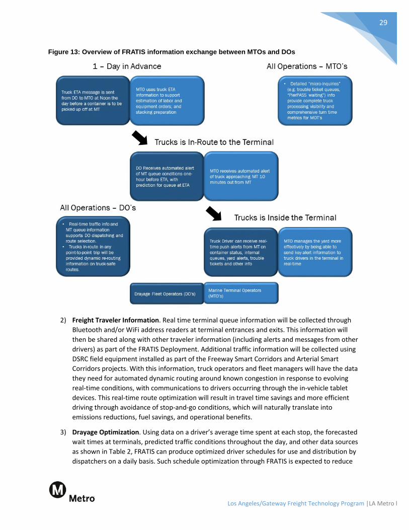
1) Information Exchange between DOs and MTOs. Two-way messaging between the MTOs and the DOs will be used to provide estimated arrival times (ETAs) for dray approaches, and will provide a method for MTOs to broadcast alerts if needed. This allows for substantial improvements in terminal management and truck management, and—when deployed on a large scale as is planned for the FRATIS Deployment—will significantly reduce peak period truck congestion at POLA and POLB terminals. This easing of peak period congestion will arise from close coordination between DOs and MTOs, enabling the scheduling of dynamic appointments that take truck dispatching status information and container availability into consideration. This information exchange will improve travel times and travel time reliability, which will naturally translate into emissions reductions, fuel savings, and operational benefits. Figure 13 shows how information flows have been designed in the FRATIS Deployment.
Los Angeles/Gateway Freight Technology Program |LA Metro l
29
Figure 13: Overview of FRATIS information exchange between MTOs and DOs
2) Freight Traveler Information. Real time terminal queue information will be collected through
Bluetooth and/or WiFi address readers at terminal entrances and exits. This information will then be shared along with other traveler information (including alerts and messages from other drivers) as part of the FRATIS Deployment. Additional traffic information will be collected using DSRC field equipment installed as part of the Freeway Smart Corridors and Arterial Smart Corridors projects. With this information, truck operators and fleet managers will have the data they need for automated dynamic routing around known congestion in response to evolving real-time conditions, with communications to drivers occurring through the in-vehicle tablet devices. This real-time route optimization will result in travel time savings and more efficient driving through avoidance of stop-and-go conditions, which will naturally translate into emissions reductions, fuel savings, and operational benefits.
3) Drayage Optimization. Using data on a driver’s average time spent at each stop, the forecasted wait times at terminals, predicted traffic conditions throughout the day, and other data sources as shown in Table 2, FRATIS can produce optimized driver schedules for use and distribution by dispatchers on a daily basis. Such schedule optimization through FRATIS is expected to reduce

Los Angeles/Gateway Freight Technology Program |LA Metro l
30
vehicle miles traveled (VMT) by 10% or more, which translates into a similar reduction in emissions and fuel consumption.
4) Freight Signal Priority. The in-vehicle tablet devices provided through the FRATIS Deployment will include DSRC communications, giving them the ability to exchange information with DSRC roadside units being deployed as part of the Arterial Smart Corridors projects and making freight signal priority possible. This CV application enables freight vehicles on properly instrumented arterials to request green phases (e.g., extensions of current green phases, or early termination of red phases) as they approach signalized intersections. This real-time signal timing priority will result in more efficient driving through the avoidance of excessive acceleration and deceleration at intersections, which will naturally translate into emissions reductions, fuel savings, and operational benefits. A simulation analysis of freight signal priority conducted by Portland State University showed that this CV application could reduce the number of freight vehicle stops on an arterial by approximately 10%.
Table 2: Summary of constraints/inputs and outputs associated with FRATIS optimization engine
Optimization constraints and inputs Optimization outputs • Distance and travel time between stops • Appointment time window at each stop • Traffic delays by time of day and day of week • Weather condition and expected delays • Construction schedules on routes • Waiting time at each stop by time of day • Drive hours of service available • Equipment-related constraints • PierPass hours of operation • Special requirements (e.g., Hazardous materials)
• Optimized plan for the day for the fleet by truck/driver
• Daily Miles driven • Total miles driven, total bobtail miles, and estimated
times of arrival. • Order status and estimated order end time per
truck/driver • Total estimated driving time and stop time • Driving hours, idle time, & standstill per driver
Metro and GCCOG are leading the FRATIS Deployment in coordination with several key stakeholders including POLA, POLB, the 13 MTOs, HTA, CTA, and CRT. System planning and recruitment is expected to begin in 2018, to ensure that this project is able to take advantage of the lessons learned from FHWA’s FRATIS Phase II program.
The first phase of the FRATIS Deployment will occur around 2020, and will include the establishment of an Operations Center to support the project. The scope of the FRATIS Deployment in this first phase is significant, and is expected to translate into meaningful fuel consumption savings for DOs, operational efficiency benefits for both vehicle operators and MTOs, and air quality improvements for all sub-regional stakeholders. These economic benefits are expected to make the Ports more competitive on a global scale, which is particularly relevant given the forthcoming completion of the Panama Canal expansion and the potential for increased competition from East Coast ports.
Eventual plans for the second phase of the FRATIS Deployment are to expand it to include 15,000 trucks and 13 marine terminals as shown in Figure 14. As this expansion occurs, arrival rates at MTOs will become more regular throughout the day, peak period queuing will become less of a problem, and terminal delays will decline, resulting in operational benefits and cost savings for both MTOs and DOs.

Los Angeles/Gateway Freight Technology Program |LA Metro l
31
Figure 14: Locations of the 13 MTOs planned for inclusion in the FRATIS Deployment
5.2.6 Zero and Near-Zero Emissions Technology
Applications for Vehicles Ensuring that ZE and NZE Class 8 drayage trucks enter the mainstream vehicle fleet is an important step toward accomplishing the sub-region’s air quality and sustainability goals.
In 2013, Metro and GCCOG conducted a study that evaluated ZE truck technologies and their ability to meet the needs of the drayage users serving the Ports, developed a
preliminary business case for the more feasible technology alternatives, and described a commercialization plan for these ZE trucks based on the technology recommendations. While the focus of this study was assessing the potential for commercialization of ZE-capable Class 8 drayage trucks, the findings indicated that the commercialization pathway for ZE trucks would need to include intermodal and domestic trucks as well. Doing so would facilitate ZE truck adoption rates, address affordability issues that might otherwise limit widespread adoption, and result in increased ZE truck purchases.
This study also concluded that ZE-capable drayage trucks could be entering into production by 2030, when accounting for the time needed for vehicle development, testing, validation, public demonstrations, and production preparations. These trucks would be designed to meet key performance requirements for drayage operations at the ports with respect to battery range, power output, and duty cycle criteria. A viable business case for these ZE-capable trucks assumed that accompanying infrastructure would be deployed in a timely manner and that targeted purchase/use incentives would be available as well.
According to the 2013 study, the key factors associated with a successful ZE truck program include:

Los Angeles/Gateway Freight Technology Program |LA Metro l
32
• Operational Flexibility — Vehicles must be capable of performing typical drayage trips, which may require a range of 200 miles per day and an engine power output capable of hauling loads of 80,000 lbs across the steepest truck routes in the region.
• Emissions Mode Flexibility — Vehicles must be capable of operating a certain minimum distance (e.g., 20 to 50 miles) in ZE mode, which would typically be engaged in the vicinity of the Ports and other areas with sensitive environments. The vehicles would potentially need to support a low-emissions mode at all other times as well.
• Ease of Production — The manufacturing process associated with these vehicles must be economically viable. It is expected that the ZE vehicles will be produced using a modified production process already in high-volume use for a current truck platform, as this approach will be more efficient than developing an entirely new process for them.
• Availability of Fuel and Power Sources — These ZE vehicles will have different fuel and power requirements than most vehicles today, and sufficient infrastructure support will be necessary to provide a suitable, viable deployment environment for a fleet of over 10,000. Power and fuel needs will need to be addressed in coordination with electric utilities and fuel providers with respect to capacity, distribution, and infrastructure locations.
• Regulatory Support and Adoption Incentives — It is anticipated that market forces alone will be insufficient to achieve the rapid level of ZE vehicle deployment targeted by the Program. Therefore, regional and state air quality and transportation agencies will need to develop regulatory frameworks in which adoption of ZE technology is rewarded and/or mandated.
Deployment of ZE and NZE freight vehicles is a core element of the I-710 Corridor Project as well. The draft Environmental Impact Report (EIR) for that project included an implementation plan for achieving widespread deployment of ZE and NZE trucks in the region. Figure 15 describes the broad level of ZE-vehicle deployment targeted by the I-710 Corridor Project.
The vehicle element of the Program’s ZE and NZE Technology component includes contributions from both the near-term aspects of the Metro/GCCOG 2013 study and the longer-term vision of the I-710 Corridor Project. Specifically, the Program involves an overall deployment of 40 ZE and NZE Class-8 trucks split evenly into two phases; the first phase occurs in the 2015-2020 timeframe, and the second phase occurs between 2020 and 2025.
The Program examines five different ZE truck architectures that could be used for this deployment:
• Dual-Mode Hybrid Electric Vehicles; • Dual-Mode Plug-in Hybrid Electric Vehicles; • Range Extended Electric Vehicles with Engines; • Range Extended Electric Vehicles with Fuel Cells; and • Battery Electric Vehicles.

Los Angeles/Gateway Freight Technology Program |LA Metro l
33
Figure 15: ZE and NZE vehicle components of the I-710 Corridor Project
The Program will establish partnerships with between three and 10 DOs in the region to support the deployment of ZE and NZE technology, with candidate partners being identified through such avenues as HTA membership and existing stakeholders associated with the Program. Once selected, the partner DOs would be responsible for: integrating the ZE and NZE vehicles into their fleets; installing fuel stations and/or recharging infrastructure on their property; and participating in field-based evaluation and testing activities associated with those vehicles.
Finally, the Program will include additional work to further develop the business case and operational models for ZE trucks. As ZE and NZE technology matures, it will become increasingly crucial that a compelling business case be clearly shown to DOs and other relevant stakeholders. In response to this need, the Program will review and revise the existing business case for ZE and NZE technology adoption considering: recent trends in battery prices and other factors, possible financial support for ZE and NZE truck purchases from regional or state organizations, and other potential financial incentives (e.g., reduced PierPass fees for ZE and NZE vehicles).

Los Angeles/Gateway Freight Technology Program |LA Metro l
34
Applications for On-Dock Rail-yards The ZE On-Dock Rail-yards Project (i.e., the “Rail-yards Project”) is the rail-yard element of the Program’s ZE and NZE Technology component, and achieves a more comprehensive, multimodal approach to the Program’s freight technology deployment. This project focuses on the expansion and electrification of on-dock rail-yards at the APM Terminal (APMT) and West Basin Container Terminal (WBCT), whose locations are shown in Figure
16. These two terminals handle approximately 10% of the nation’s containers, at an estimated value of $83 billion.
Specifically, additional track will be installed for increased capacity, and container operations will be switched from diesel-powered top-pick methods to four fully electrified rail-mounted gantry (RMG) cranes at each of the two rail-yards. This project will also increase utilization of rail for the movement of freight through the sub-region by facilitating the loading of containers directly onto trains.
It should be noted that POLA is also submitting this project separately to the Air Resources Board (ARB).
The Rail-yards Project is strategically positioned at key access points for the regional and national intermodal freight transportation network, as shown previously in Figure 3.
The Rail-yards Project is included in both the California Freight Mobility Plan (CFMP, project #100710) and the 2016 SCAG Regional Transportation Plan (anticipated for draft release in December, 2015). It also satisfies every goal of the CFMP and qualifies as an Integrated Action Plan as required by Governor Brown’s Executive Order B-32-15. An Environmental Impact Report is currently being assembled for the WBCT portion of the Rail-yards Project, with approval anticipated by mid-2017. For the corresponding APMT portion of the project, a “mitigated negative” declaration is expected to be formally approved in the third quarter of 2016.
The goals of the Rail-yard Project include:
• Environmental Stewardship, which is achieved through the project’s use of alternative fuels and ZE technologies.
• Infrastructure Preservation, which is achieved through an expected reduction in truck VMT, as this project is designed to increase rail utilization for the transport of terminal containers.
• Congestion Relief, which is achieved through an expected reduction in truck VMT and corresponding reduction in congestion.
• Enhanced Safety, which is achieved through an expected reduction in congestion and corresponding decrease in incident occurrence.
• Increased Economic Competitiveness and Freight Efficiency, which is accomplished by providing terminals with on-dock rail capabilities in place of former off-dock facilities, and by switching from cargo-handling equipment (CHE) to RMG.
• Application of Innovative/Advanced Technology, including electrification of all on-dock rail operations at the two terminals.

Los Angeles/Gateway Freight Technology Program |LA Metro l
35
Figure 16: Locations of the APMT and WBCT rail-yards at POLA
With respect to project benefits, on-dock intermodal infrastructure has been shown to reduce the number of container truck trips generated by a terminal by 35-50%. By improving operations and expanding capacity at the APMT and WBCT rail-yards, it is therefore anticipated that truck traffic will be reduced as rail utilization increases—an outcome that addresses a key goal from USDOT’s draft strategic

Los Angeles/Gateway Freight Technology Program |LA Metro l
36
plan as well (i.e., increasing the number of freight containers transported by rail). This reduction in traffic will naturally be accompanied by reductions in congestion, improvements in travel time reliability, reduced emissions, and reduced roadway maintenance costs.
As a strategy that improves the operational efficiency of container handling at the Ports, the Rail-yards Project is a key element of the POLA’s capital improvement program. The Rail-yards project also contributes to the efficient movement of goods (including intermediate products that are used as inputs to manufacturing processes in the United States, such as automobile components) from the Ports to inland distribution centers and destinations across the continent, making this a crucial part of the nation’s system if intermodal transportation and trade. The Rail-yards project specifically seeks to increase the competitiveness of the Ports on a global scale, strengthening the sub-region’s economy while simultaneously enhancing livability for its residents.
Additional benefits and outcomes associated with the Rail-yard Project include:
• More efficient and reliable movement of containers and reduced end-to-end travel times resulting from the use of RMG and rail transport.
• Reduced inventory/storage costs for manufacturers and freight carriers, who benefit from lower safety stock requirements as travel time reliability improves.
• Emissions reductions associated with a decrease in locomotive delays, also resulting from the use of RMG in concert with other POLA and POLB rail system projects. Specifically, these projects are estimated to save 50 train-hours every day.
• Improved public health, conservation of diesel fuel, and additional emissions reductions associated with a decrease in truck trips. Specifically, the Rail-yard Project is estimated to save 700 truck trips and 7,600 truck VMT every day.
• Increased rail-yard productivity and reduced transportation costs resulting from the switch to on-dock rail (in place of former off-dock rail) and RMG (in place of former CHE).
• Enhanced safety resulting from the reduction in drayage truck trips on adjacent arterials and freeways, including I-710.
5.3 Benefits of the Program An analysis was conducted to provide estimates for the emissions benefits associated with the Program, using a sketch-planning method. This analysis does not include the impact of NZE or ZE fleet deployments; those calculations are being performed at a much higher level of fidelity as part of the I-710 Corridor Project, and are not yet available.
Beyond the emissions savings indicated here, significant mobility benefits have been documented for various elements of this program. For example, a benefit-cost analysis was conducted for the Arterial and Freeway Smart Corridors using the FHWA Tool for Operations Benefit Cost Analysis (TOPS-BC), which revealed a 4:1 benefit-cost ratio for the arterial component and a 10:1 benefit-cost ratio for the freeway component.

Los Angeles/Gateway Freight Technology Program |LA Metro l
37
For this emissions analysis, the coverage area includes the eight Arterial Smart Corridors and two Freeway Smart Corridors:
Arterials 1. Alameda Street 2. Bandini Boulevard 3. Del Amo Boulevard 4. Cherry Avenue & Garfield Avenue 5. Pacific Coast Highway 6. Slauson Avenue 7. Firestone Boulevard
Freeways 1. I-110 2. I-710
The analysis considers potential emissions reductions from the following strategies:
• ICM and ATM (e.g., Smart Corridors) • FRATIS & Freight Logistics Optimization • Eco-Driving • Freeway Traveler Information Systems with Dynamic Routing • Freeway Incident Management • Arterial Incident Management • Arterial Signal Coordination or Adaptive Signal Control • Signal Priority • Dynamic Lane Management/Use
Altogether, the strategies are conservatively estimated to result in a health benefit of $10 million annually. The results can be found in Table 3.
Table 3: Estimated annual emissions benefits of the Program
Estimated Annual Outcome
Emissions CO CO2 NOX PM10 SOX VOC
Emissions Saved (tons/year) 403 58,596 72.49 7.78 0.611 34.4 Health Benefit ($/year) $58,489 $1,347,703 $4,283,936 $3,767,462 $111,278 $126,275
A separate emissions analysis was performed for the Rail-yards Project. This project will significantly reduce terminal and truck emissions, thereby improving air quality for all stakeholders in the area. These results are conservative, as they do not account for decreased rail locomotive operating hours as a result of the improved rail system infrastructure. Table 4 summarizes the estimated annual rail emissions reductions that would be achieved by each terminal based on 2014 conditions, while Table 5 indicates the accompanying annual truck emissions reductions achieved in 2030.

Los Angeles/Gateway Freight Technology Program |LA Metro l
38
Table 4: Annual emissions reductions (in tons) associated with the transition from CHE to RMG
Terminal CO CO2 NOX PM Hydrocarbons WBCT 406 34,389 180.9 5.3 43.1 APMT 97.8 35,921 147.2 6.3 11.2
Table 5: Annual emissions reductions (in tons) associated with truck trip reductions
Emissions Type CO CO2 NOX PM Hydrocarbons Annual reduction (tons) 13 5,522 21 0.9 1.0
The POLA can monitor progress toward achieving these estimated emission reductions through its annual emissions inventory analysis, which it has performed since 2005.
5.4 Local Economic Development Impact In 2014, the California EPA released the California Communities Environmental Health Screening Tool 2.0 (CalEnviroScreen), which compares every census tract in the state based on environmental and population risk factors. This tool is used as a standardized method for identifying disadvantaged communities in California for purposes of Cap-and-Trade and Active Transportation funding decisions; those that score at or above the 75th percentile (i.e., are in the top 25 percent) are formally recognized as disadvantaged.
As illustrated in Figure 17, over 61 percent of residents in the Program area are in disadvantaged communities, with 31 percent living in the areas that ranked above 90%. The sub-region is also racially and socioeconomically diverse: the median household income for the region is close to $55,000, though approximately 20 percent of the population lives below the poverty line; furthermore, a large proportion of the population is composed of minorities and immigrants, and the economically disadvantaged. The sub-region is therefore a prime candidate for the types of economic benefits and quality-of-life improvements associated with the Program.
To illustrate some of the economic benefits that this Program would yield to the sub-region, an expansion of FRATIS at the scale outlined in this program would afford significant economic returns in the form of quicker turn times at terminals, improved travel times to distribution centers, and associated cost savings to drivers and operators associated with those direct benefits. In an industry where cutting even pennies off of delivery costs can result in high-volume returns on a quarterly scale, FRATIS has the potential to make a significant impact on the productivity and competitiveness of the local drayage community and associated industries, as well as the broader economic development of both the Program area and the region as a whole. The traveling public also benefits from improved mobility and travel time reliability resulting from more efficient utilization of the freeway and arterial network.

Los Angeles/Gateway Freight Technology Program |LA Metro l
39
Figure 17: CalEnviroScreen scores throughout the study region (higher percentages indicate more disadvantaged areas)

Los Angeles/Gateway Freight Technology Program |LA Metro l
40
The cost savings associated with the various improvements included in the Program will improve the competitiveness of U.S. products in world markets, draw additional business and investment to the area, and contribute to the retention of current businesses in the sub-region. Moreover, studies have shown that reductions in logistics costs generate significant increases in industrial output, improvements in industry productivity, and reductions in production costs. Such increases in industrial output and productivity promote economic health by creating more jobs and increasing average wages—a particularly relevant outcome for this sub-region given its current 13% unemployment rate.
Specific benefits of the ZE and NZE vehicle project Substantial opportunities for economic development are also presented by the ZE and NZE elements of the Program, as the final assembly stage for these vehicles could be contracted to the local manufacturing industry. Such an approach would be efficient and prudent, as it would invoke the repurposing and/or reviving of existing facilities that are currently going underutilized. Furthermore, by engaging DOs throughout the sub-region early in the ZE and NZE development process, their feedback can be used to guide the design of these vehicles and their accompanying institutional programs, allowing for more relevant designs, more tractable integration paths and implementation plans, and a more compelling business case for adoption. Positioning the sub-region as a proven provider of these crucial design and assembly stages for the ZE and NZE vehicle supply chain could yield substantial additional benefits to the local economy as the ZE and NZE initiative continues to grow and demand for those vehicles continues to rise.
Similarly, by implementing the final stages of ZE and NZE vehicle production locally, businesses and service providers in the Gateway Cities area have an opportunity to position this sub-region as a national hub for ZE and NZE vehicle maintenance and training. Training programs will be needed to support DOs both during the initial deployment of vehicles into their fleets and on an ongoing basis to ensure maintenance staffs and operators remain current on the latest ZE technologies and best practices. To facilitate successful ZE and NZE deployments, fleet managers and operators will benefit from training and guidance regarding the selection of appropriate vehicle options to suit their needs, and the transition to higher voltage systems and new driveline architectures to support the new vehicles.
These fleet maintenance roles align perfectly with regional, state and national initiatives—notably the Los Angeles Community College District’s Sustainability and Workforce Development Initiative (i.e., the “Development Initiative”), and the Career Pathways Programs developed jointly between the US Departments of Education, Transportation, and Labor. The Development Initiative focuses on providing or enhancing environmental protection, economic performance, and social equity by creating educational programs in Los Angeles County that emphasize emerging environmentally responsible industries and by positioning community colleges as global leaders in the development of environmentally sensitive technologies. Given the substantial overlap between the goals of the Program and the goals of the Development Initiative, it is both reasonable and prudent to work closely with the community colleges through this initiative to design suitable curricula that incorporates coverage of ZE and NZE vehicle deployment. This approach also fulfills a Career Pathways Programs objective of establishing relevant workforce training for the transportation industry.
Fleet maintenance training programs and workforce education curricula at community and vocational schools will provide a solid local foundation for the emerging ZE and NZE industry by increasing

Los Angeles/Gateway Freight Technology Program |LA Metro l
41
awareness, familiarity, and comfort with the technology. These programs can be offered by traditional fleet support associations, state and regional trucking associations, and the community college network. Relevant types of training would cover best practices regarding fleet management, adoption incentives, vehicle maintenance, and accompanying regional infrastructure.
To support the continued local expansion of the ZE and NZE aspects of the Program and the realization of associated air quality benefits, the following will also be essential:
• Strong market support for ZE vehicles, components (e.g., batteries, electric drivelines), manufacturing, and deployment.
• Clearly communicated roles, requirements, and expectations for ZE vehicles from vehicle and equipment manufacturers.
By addressing these needs and other key factors that influence the success of ZE and NZE deployments on a local level, the Program is designed to strategically position this sub-region as a national hub for ZE and NZE vehicle maintenance and training in the future, thereby establishing a powerful and dependable economic engine for the region moving forward. For example, strong market support can be achieved through appropriate investments in local infrastructure as described in the Program, as well as extension to other markets beyond local DOs and the Ports, such as vocational trucks, buses, and freight/drayage markets in other parts of the world (e.g., the East Coast, the Gulf Coast, Europe, Asia).

Los Angeles/Gateway Freight Technology Program |LA Metro l
42
6.0 Estimated Costs Estimated costs for the major components of each core Program element are summarized by program phase (i.e., Phase I or Phase II) in Table 6. This information can be used to make suitable investment decisions and adjustments in response to the timing and availability of funds to support the Program. For example, if ARB were to contribute $10 million in funds to support this Program, that amount could be used to deploy approximately 40% of the 5,000 trucks planned as part of Phase I of the FRATIS deployment project, or to implement the Arterial Smart Corridor improvements on both Alameda St and Bandini Blvd. These costs are only preliminary, and will be further refined by Metro as part of its detailed project scoping process as funding becomes available (which may also include changes to the specifics of individual Program elements).
Table 6: Summary of costs by Program component
Program Element Phase I Costs (in millions)
Phase II Costs (in millions)
Arterial Smart Corridors project Alameda St $7.3
Bandini Blvd $2.7 Cherry Ave/Garfield Ave $7.0 Del Amo Blvd $1.9 Manchester Ave/Firestone Blvd
$4.6
Pacific Coast Highway
$3.0 Slauson Ave
$2.0
Washington Blvd
$5.0 Freeway Smart Corridors project
Deploy ITS and CV on I-710 $35 Deploy ATM/ICM strategies on I-710 $35 Deploy ITS and CV on I-110
$46
Deploy ATM/ICM strategies on I-110
$38 TENS on freeway system $40 $60
FRATIS Deployment project Deploy initial 5,000 trucks in Phase I ($5,000 per truck) $25
Deploy remaining 10,000 trucks in Phase II ($5,000 per truck)
$50 ZE and NZE Truck Deployment project
Deploy initial 20-25 trucks in Phase I ($2 million per truck) $40 Deploy remaining 20-25 trucks in Phase II ($2 million per truck)
$40
Rail-yards project1 WBCT RMG on-dock Rail-yard $80
APMT RMG on-dock Rail-yard $100 1Rail-yard costs include $28 million each for crane facilities.

Los Angeles/Gateway Freight Technology Program |LA Metro l
43
7.0 Timeline The Program encompasses six projects (i.e., Arterial Smart Corridors, Freeway Smart Corridors, the FRATIS Deployment, ZE and NZE Truck Deployment, the Rail-yards project, and CV technology deployment) that could be completed by 2030 if funding is available. A phased approach was developed in response to the uncertainty associated with the availability of sufficient funds to support the full Program project agenda over the coming 15 years. This approach was designed to yield consistent progress across each of the six component projects in each phase, with full deployment achieved by the end of Phase III as shown in Figure 18. The scope of each Phase is subject to change in response to the availability of funding in each timeframe. Note that the Program details presented in this document are focused only on Phases I and II, with Phase III to occur in parallel with the completion of the I-710 Corridor Project.
Figure 18: High-level timeline for the three deployment phases of the Program

Los Angeles/Gateway Freight Technology Program |LA Metro l
44
8.0 Measuring Progress towards Goals The primary goal of this program is to use ITS and CV technologies to: improve freight operations; more efficiently utilize the rail, freeway, and arterial transportation networks; and provide an enhanced standard of living for residents of the sub-region through improved air quality, reduced congestion, and increased economic health. A before-and-after approach will be applied to measure progress toward these goals as the Program is implemented, as described below.
• Traditional Assessment of Before-and-After Performance. Baseline comparison data (i.e., “before” data) will be collected during the planning and design period of Phase I, which is expected to span the first 12-18 months of the phase. Data types and sources will include: GPS data from equipped vehicles; operational performance data from fleet managers; traffic data for arterials and freeways from Caltrans, local agencies, and third parties; and terminal queue data from the 13 MTOs. For comparative analysis, data will also be collected after the Phase I technologies have been implemented/deployed (i.e., the “after” data). These two datasets will then be analyzed to evaluate the Phase I impacts of the Program across several dimensions including emissions reductions and mobility improvements, with the results used to assess the extent to which the Program is meeting its performance objectives.
• Electronic Direct Measurement of Before-and-After Performance. A minimum of 250 trucks will be equipped with emissions-monitoring equipment during the early planning stage of Phase I, allowing for the collection of at least a year of “before” data prior to the deployment of Phase I technologies, in addition to “after” data for comparison after the deployment occurs. This approach will yield direct measurements of the emissions reductions achieved by the Program, and will provide more precise indicators of how effectively it is fulfilling its performance goals.
Real-time or near-real-time performance monitoring of the system will be supported by the DSRC equipment and other field devices deployed in Phase I, and implemented using a TMC software module. This data will be shared to other regional stakeholders through Metro’s Arterial Performance Measurement Framework Feasibility Study (i.e., the “MeasureUp” program), which seeks to develop a consistent, mobility-focused arterial performance measurement system across LA County. This data will also support performance tracking over time, and will provide necessary feedback for the continual optimization of Program-related operations in pursuit of ever-increasing performance outcomes for the sub-region (e.g., emissions reductions that exceed the initial targets of the Program).
The technical approach for performance evaluation will be summarized in a Program evaluation plan, which will conform to USDOT best practices regarding ITS evaluations. The evaluation plan will define the specific hypotheses to be tested, the performance metrics that will be used to evaluate those hypotheses, the requirements and potential sources for data, and the analysis methods that will be followed. The evaluation plan will take advantage of available outputs and resources provided through applicable performance measurement initiatives already underway (e.g., the MeasureUp program), and will establish the formal framework for evaluating the extent to which the Program accomplished its performance objectives. Figure 19 shows a summary graphic illustration of another evaluation which followed these same principles and approach.

Los Angeles/Gateway Freight Technology Program |LA Metro l
45
Figure 19: Example intermodal freight technology evaluation near-real time performance monitoring system

Los Angeles/Gateway Freight Technology Program |LA Metro l
46
9.0 Interagency Partnerships and Roles Metro, POLA, and GCCOG will engage local agencies, partner organizations, and other sub-regional stakeholders to establish new partnerships and strengthen existing relationships in support of this Program. The key partners and stakeholders listed in Table 7 will be vital to ensuring a successful implementation of the various projects included the Program, with additional stakeholders added to the list as appropriate on an ongoing basis. Furthermore, to demonstrate their agreement with and commitment to the goals, objectives, and requirements of this Program, stakeholders listed in Table 7 have provided formal letters declaring their support (these have been included with this submittal, with more forthcoming).
Table 7: Key agencies and stakeholders associated with the Program
Stakeholder Description Roles Metro Los Angeles County’s regional transit service provider,
regional transportation planning agency, and administrator of the local transportation sales tax initiatives. Metro is responsible for the continuous improvement, efficiency, and effectiveness of LA County’s transportation system.
• Lead agency in coordinating and/or implementing a majority of the projects included in the Program.
Caltrans State agency responsible for improving mobility across California. Caltrans is responsible for operating, maintaining, and improving freeway and highway facilities, in addition to inter-city rail and air transportation infrastructure in the state.
• Coordination with Metro on all projects involving I-110, I-710, and state highways.
• Provide input and oversight for improvements to the state highway system.
• Provide input for the Arterial Smart Corridors project.
• Perform advising role for TENS. LADPW County agency that maintains over 1,800 traffic signals in
Los Angeles—many of which are within the Program area limits.
• Coordination with Metro on the Arterial Smart Corridors project.
• Provide data to support the overall Program.
• Provide oversight and input for the Arterial Smart Corridors and Freeway Smart Corridor projects.
City of Los Angeles
Operator of the most advanced adaptive signal system in the nation encompassing over 4,000 traffic signals—many of which are within the Program area limits.
• Coordination with Metro on the Arterial Smart Corridors project, including input and oversight.
• Provide oversight and input for the Arterial Smart Corridors and Freeway Smart Corridor projects.
GCCOG A council of representatives from 27 cities within the Gateway Cities sub-region, which largely overlaps with the Program limits. GCCOG has been a key sponsor of transportation projects in the Gateway Cities area.
• Planning and design support for various elements in the Program.
• Coordination with local cities and their TMCs.
• Operations and maintenance support for the Arterial Smart Corridors project.
Los Angeles/Gateway Freight Technology Program |LA Metro l
47
Stakeholder Description Roles The Ports With 13 MTOs split across POLA and POLB, the Ports are
the focal points of drayage truck movement in the Los Angeles area, and are a key access point for goods and freight destined for other locations across the country.
• Provide input and support for the FRATIS Deployment project.
• Engage the MTOs and DOs. • Provide input for the Rail-yards
Project. South Coast Air Quality Management District
The agency responsible for controlling air pollution in LA County and other neighboring counties. It maintains an Air Quality Management Plan that functions as a strategy for meeting federal and state clean air standards in the South Coast region.
• Provide input and support for various elements in the Program.
• Provide feedback on ZE and NZE projects.
• Identify other programs and projects that align with the design and objectives of this Program.
SCAG The Metropolitan Planning Organization for the Los Angeles region. It recently completed a Comprehensive Regional Goods Movement Plan and Implementation Strategy, which now functions as a long-range plan for goods movement in the region.
• Provide feedback and support regarding integration between the Program and SCAG’s long-range plan.
• Provide input and support for various elements in the Program.
DOs Responsible for transporting goods between the Ports and distribution centers. The list of specific DOs associated with this Program will continue to expand as Phase I progresses and additional relevant partners and stakeholders are identified.
• Direct participation in the FRATIS Deployment project.
• Provide input and feedback during the development stage of the FRATIS Deployment project.
• Provide details about DO operations to support Program design.
MTOs Function as the link between ocean freight carriers and DOs. The list of specific MTOs associated with this Program will continue to expand as Phase I progresses and additional relevant partners and stakeholders are identified.
• Direct participation in the FRATIS Deployment and Rail-yard Projects.
• Provide input and feedback during the development stage of the FRATIS Deployment an Rail-yard Projects.
• Provide details about MTO operations to support Program design.
Southern California Consensus Group
A coalition of all transportation funding agencies in Southern California: SCAG, Metro, the Ports, Orange County Transportation Authority, Riverside County Transportation Commission, San Bernardino Associated Governments, Ventura County Transportation Commission, Alameda Corridor-East Construction Authority, Alameda Corridor Transportation Authority, Southern California Regional Rail Authority, and the Port of Hueneme.
• Identify funding opportunities. • Provide planning and
development input for the Rail-yard Project.

Los Angeles/Gateway Freight Technology Program |LA Metro l
48
A.1 List of Acronyms and Aliases
Acronyms and definitions used in this document Acronym Definition Acronym Definition APMT APM Terminal ICM Integrated Corridor Management ARB Air Resources Board IEN Information Exchange Network ATM Active Traffic Management ITS Intelligent Transportation Systems ATMS Advanced Traffic Management System LADPW Los Angeles County Dept. of Public Works CalSTA California State Transportation Agency MMITSS Multimodal Intelligent Traffic Signal System CARB California Air Resources Board MTO Marine Terminal Operator
CCTV Closed-Circuit Television Camera(s) NOX Nitrogen Oxides (emissions) CEQA California Environmental Quality Act NZE Near-Zero Emissions CFMP California Freight Mobility Plan PLG Port Logistics Group
CHE Cargo-Handling Equipment PMX Particulate Emissions up to X µm in size CHP California Highway Patrol POLA Port of Los Angeles CMS Changeable Message Sign(s) POLB Port of Long Beach CO Carbon Monoxide (emissions) RIITS Regional Integration of ITS CO2 Carbon Dioxide (emissions) RMG Rail-Mounted Gantry
CRT Coalition for Responsible Transportation SCAG Southern Calif. Association of Governments
CTA California Trucking Association SOX Sulfur Oxides (emissions) CV Connected Vehicle(s) TENS Truck Enforcement Network System DO Drayage Fleet Operator TEU Twenty-foot Equivalent Units DSRC Dedicated Short Range Communications TMC Transportation Management Center EIR Environmental Impact Report TOPS-BC Tool for Operations Benefit Cost Analysis EPA Environmental Protection Agency USDOT United States Dept. of Transportation ETA Estimated Time of Arrival VMT Vehicle miles traveled FRATIS Freight Advanced Traveler Info. System VOC Volatile Organic Compound (emissions) GCCOG Gateway Cities Council of Governments WBCT West Basin Container Terminal GHG Greenhouse Gas YTI Yusen Terminals, Inc. HTA Harbor Trucking Association ZE Zero Emissions
Aliases and definitions used in this document Alias or Phrase Definition or Meaning Arterial Smart Corridors Project Arterial Smart Corridors for Goods Movement Project CalEnviroScreen California Communities Environmental Health Screening Tool 2.0 Development Initiative Los Angeles Community College District’s Sustainability and Workforce
Development Initiative FRATIS Deployment New FRATIS Full-Scale FRATIS Deployment Project included in the Program FRATIS Phase I Small-scale test program for first FRATIS Deployment between 2011 and 2014 FRATIS Phase II Full-scale test program for FRATIS through 2018

Los Angeles/Gateway Freight Technology Program |LA Metro l
49
Alias or Phrase Definition or Meaning Freeway Smart Corridors Project Freeway Smart Corridor for Goods Movement project I-10 Santa Monica Freeway, Interstate 10 I-405 San Diego Freeway, Interstate 405
I-605 Interstate 605 I-710 Long Beach Freeway, Interstate 710 I-710 Corridor Project I-710 Corridor Reconstruction and Improvement Project MeasureUp Metro Arterial Performance Measurement Framework Metro Los Angeles County Metropolitan Transportation Authority Rail-yards Project Zero-Emissions On-Dock Rail-yards Project
SR-1 Pacific Coast Highway, State Route 1
SR-60 Pomona Freeway, State Route 60
SR-91 Artesia Freeway, Gardena Freeway, State Route 91 The Ports POLA and POLB, collectively The Program The Los Angeles/Gateway Freight Technology Program

Los Angeles/Gateway Freight Technology Program |LA Metro l
50
A.2 Letters of Support

“Provide a safe, sustainable, integrated and efficient transportation system
to enhance California’s economy and livability”
STATE OF CALIFORNIA------- CALIFORNIA STATE TRANSPORTATION AGENCY EDMUND G. BROWN Jr., Governor
DEPARTMENT OF TRANSPORTATION DISTRICT 7 100 S. MAIN STREET, SUITE 100
LOS ANGELES, CA 90012
PHONE (213) 897-0362
FAX (213) 897-0360
TTY 711
www.dot.ca.gov
Serious Drought.
Serious drought. Help save water!
November 18, 2015
Ms. Mary D. Nichols
Chair, California Air Resources Board
P.O. Box 2815
Sacramento, CA 95812
Dear Ms. Nichols:
The California Department of Transportation (Caltrans), District 7, Los Angeles is pleased to
offer this Letter of Support for the Los Angeles/Gateway Freight Technology Program (Program)
being submitted by the Los Angeles County Metropolitan Transportation Authority (Metro). This
effort is in response to Governor Brown’s Executive Order B-32-15 to improve freight
efficiency, transition to zero-emission technologies, and increase competitiveness of California’s
freight system. The Los Angeles region is an ideal location for future freight pilot projects. It is
home to the largest port complex in the United States, the heavily freight traveled Interstate 710
corridor, and high concentrations of distribution warehouses adjacent to residential land uses.
Metro, in cooperation with the Caltrans, City of Los Angeles, County of Los Angeles
Department of Public Works, Gateway Cities Council of Governments, Ports of Long Beach and
Los Angeles, South Coast Air Quality Management District, and Southern California
Association of Governments have developed the Program to utilize technology on freight trucks
and infrastructure to reduce greenhouse gas (GHG) emissions, improve mobility on streets and
freeways, and to maintain the economic vitality in the region. The Program includes Pilot
Projects such as:
Freight Advanced Traveler Information System (FRATIS) Deployment (approximately
15,000 trucks);
Zero/Near-Zero Emission Trucks (approximately 40 trucks);
Arterial Smart Corridors: Deploying Connected Vehicle and Intelligent Transportation
Systems (ITS) strategies on freight corridors (approximately 273 intersections, 8
corridors);
Freeway Smart Corridors: Deploying Connected Vehicle, ITS, and Integrated Corridor
Management strategies on the I-710 and I-110 freeways;
Connected Vehicle Technology: Equipping FRATIS trucks and Zero/Near-Zero
Emission trucks to communicate with the Arterial and Freeway Smart Corridors; and
On-Dock Rail Technology: on-dock railyards with electrified cranes

Ms. Mary D. Nichols
November 18, 2015
Page 2
“Provide a safe, sustainable, integrated and efficient transportation system
to enhance California’s economy and livability”
We support the use of technologies, and are committed to collaborating with Metro to implement
the Program. The Program is an opportunity that Metro is well positioned to lead in the
Los Angeles region. Metro, along with local agencies, have studied and implemented connected
vehicle, ITS, and Zero/Near-Zero Emission truck technologies to improve the movement of
people and goods, and reduce greenhouse gas emissions. These Pilot Projects would provide a
near-term solution to the I-710 corridor, and would complement the long-term vision for clean
freight transportation in the Los Angeles region.
We look forward to working with ARB and Metro, as well as other state and regional
stakeholders to develop and deploy successful pilot projects in Los Angeles.
Sincerely,
CARRIE L. BOWEN
District Director
c: Ed Alegre, Metro, Transportation Planning Manager


November 23, 2015
Mary D. Nichols
Chair, California Air Resources Board
P.O. Box 2815
Sacramento, CA 95812
Subject: California Sustainable Freight Action Plan – Pilot Project Ideas
Dear Chair Nichols,
The Southern California Association of Governments (SCAG) is pleased to offer
this Letter of Support for the Los Angeles/Gateway Freight Technology Program
(Program) being submitted by the Los Angeles County Metropolitan
Transportation Authority (Metro). This effort is in response to Governor Brown’s
Executive Order B-32-15 to improve freight efficiency, transition to zero-
emission technologies, and increase the competitiveness of California’s freight
system. The SCAG region is an ideal location for future freight pilot projects. It is
home to the largest port complex in the United States, the heavily freight traveled
Interstate 710 corridor, and high concentrations of distribution warehouses
adjacent to residential land uses.
Metro, in cooperation with the Caltrans, City of Los Angeles, County of Los
Angeles Department of Public Works, Gateway Cities Council of Governments,
Ports of Long Beach and Los Angeles, South Coast Air Quality Management
District, and Southern California Association of Governments have developed the
Program to utilize technology on freight trucks and infrastructure to reduce
greenhouse gas (GHG) emissions, improve mobility on streets and freeways, and
to maintain the economic vitality in the region. The Program includes Pilot
Projects such as:
• Freight Advanced Traveler Information System (FRATIS) Deployment
(approximately 15,000 trucks);
• Zero/Near-Zero Emission Trucks (approximately 40 trucks);
• Arterial Smart Corridors: Deploying Connected Vehicle and Intelligent
Transportation Systems (ITS) strategies on freight corridors
(approximately 273 intersections, 8 corridors);
• Freeway Smart Corridors: Deploying Connected Vehicle, ITS, and
Integrated Corridor Management strategies on the I-710 and I-110
freeways;
• Connected Vehicle Technology: Equipping FRATIS trucks and
Zero/Near-Zero Emission trucks to communicate with the Arterial and
Freeway Smart Corridors; and
• On-Dock Rail Technology: on-dock railyards with electrified cranes
SCAG has supported and promoted the development and deployment of new
technologies where applicable to improve the efficiency of the goods movement

system and to reduce air quality impacts. We support the use of the described
technologies, and are committed to collaborating with Metro to implement the
Program. The Program is an opportunity that Metro is well positioned to lead in
the Los Angeles region. Metro, along with local agencies, has studied and
implemented connected vehicle, ITS, and Zero/Near-Zero Emission truck
technologies to improve the movement of people and goods and reduce
greenhouse gas emissions. These Pilot Projects would provide a near-term
solution to the I-710 corridor, and would complement the long-term vision for
clean freight transportation in the Los Angeles region.
We look forward to working with ARB and Metro, as well as other regional
stakeholders to develop and deploy successful pilot projects in Los Angeles.
Sincerely,
Hasan Ikhrata
Executive Director
Southern California Association of Governments (SCAG)
cc: Ed Alegre, LA Metro, Transportation Planning Manager