Embed Size (px)
DESCRIPTION
1
Citation preview


Copyright © 1997 Environmental Systems Research Institute, Inc.All rights reserved.Printed in the United States of America.
The information contained in this document is the exclusive property of Environmental Systems Research Institute, Inc.This work is protected under United States copyright law and other international copyright treaties and conventions. Nopart of this work may be reproduced or transmitted in any form or by any means, electronic or mechanical, includingphotocopying and recording, or by any information storage or retrieval system, except as expressly permitted in writingby Environmental Systems Research Institute, Inc. All requests should be sent to Environmental Systems ResearchInstitute, Inc., 380 New York Street, Redlands, CA 92373-8100 USA, Attention: Contracts Manager.
The information contained in this document is subject to change without notice.
U.S. GOVERNMENT RESTRICTED/LIMITED RIGHTSUse, duplication, and disclosure by the U.S. Government are subject to restrictions as set forth in FAR ¤52.227-14Alternate III (g)(3) (JUN 1987), FAR ¤52.227-19 (JUN 1987), and/or FAR ¤12.211/12.212 [Commercial TechnicalData/Computer Software], and DFARS ¤252.227-7015 (NOV 1995) [Technical Data] and/or DFARS ¤227.7202[Computer Software], as applicable. Contractor/Manufacturer is Environmental Systems Research Institute, Inc., 380New York Street, Redlands, CA 92373-8100 USA.
ARC/INFO, ArcCAD, ArcView, ESRI, and PC ARC/INFO are registered trademarks; ADF, AML, ARC COGO, ARCGRID, ARCÊNETWORK, ARC News, ARC TIN, ARC/INFO LIBRARIAN, ARC/INFOÑThe World's GIS, ArcAtlas,ArcBrowser, ArcCensus, ArcCity, ArcDoc, ARCEDIT, ArcExpress, ARCPLOT, ArcPress, ArcScan, ArcScene,ArcSchool, ArcSdl, ARCSHELL, ArcStorm, ArcTools, ArcUSA, ARCware, ArcWorld, Atlas GIS, AtlasWare, Avenue,BusinessMAP, DAK, DATABASE INTEGRATOR, DBI Kit, ESRIÑTeam GIS, ESRIÑThe GIS People, FormEdit,Geographic Table of Contents, Geographic User Interface, Geographic User System, GIS by ESRI, GIS for Everyone,GISData Server, IMAGE INTEGRATOR, MapObjects, PCÊARCEDIT, PCÊARCPLOT, PCÊARCSHELL, PCÊDATACONVERSION, PCÊNETWORK, PCÊOVERLAY, PCÊSTARTER KIT, SDE, SML, Spatial Database Engine,TABLES, the ARC COGO logo, the ARC GRID logo, the ARC NETWORK logo, the ARC TIN logo, the ARC/INFOlogo, the ArcCAD logo, the ArcCAD WorkBench logo, the ArcData logo, the ARCEDIT logo, the ArcExpress logo, theARCPLOT logo, the ArcPress Logo, the ArcScan logo, the ArcStorm logo, the ArcTools logo, the ArcView logo, theAtlas GIS logo, the Avenue logo, the BusinessMAP logo, the ESRI corporate logo, the ESRI globe logo, theMapObjects logo, the PCÊARC/INFO logo, the SDE logo, The World's Leading Desktop GIS, ViewMaker, and YourPersonal Geographic Information System are trademarks; and ArcData, ARCMAIL, ArcOpen, ArcQuest, ArcWeb, Rent-a-Tech, www.esri.com, and @esri.com are service marks of Environmental Systems Research Institute, Inc.
The names of other companies and products herein are trademarks or registered trademarks of their respective trademarkowners.

J-7558
An ESRI White Paper i
Organizational Structure forLocal Government GIS:A Survey
An ESRI White Paper
Contents Page
Introduction 1
Executive Summary of Survey Results 2
Key Findings 15
Appendix AÑQuestionnaire Responses 21


J-7558
An ESRI White Paper
Organizational Structure forLocal Government GIS:A Survey
Introduction Local governments are increasingly required to operate with the speed andefficiency of private business while facing ever more complex political andregulatory issues. Local governments must digest an immense amount ofinformation to perform their duties in a fair and sound manner. Ageographic information system (GIS) provides the data management toolsfor the map and spatial data needed to accomplish this task. GIS technologyprovides a flexible set of tools to perform the diverse functions ofgovernment. More important, it makes data sharing among departmentspossible so that the government can work as a single enterprise.
But GIS is so much more than just technology. At its core is geography, which is across-cutting discipline, that affects all aspects of life. Geography is a key element in thedecision making, information management, and operation/maintenance of governmentservices.
GIS has five componentsÑdata, hardware, software, applications, and people.Developing and incorporating GIS into a multifunctional operation requires considerableattention be paid to each one of its five components to reap the potential benefits. At thecenter is the sharing of common spatial data. Providing an organizational structure thatfosters and promotes that sharing most efficiently can be key to the success or failure ofthe system. Unlike the technological or data components, which can be isolated, defined,analyzed, and easily manipulated to serve any function, the people (organizational)component requires attention to human resources and relationships, much more nebulousfactors.
Environmental Systems Research Institute, Inc. (ESRI), surveyed eleven large cities andcounties with GIS to learn how they have set up their organizational structureÑwhatworks, what doesn't work. The survey provides some guidelines on how a governmentcould organize itself to most effectively incorporate GIS into its daily operations. Surveyresults are summarized below. Individual responses of the organizations are provided inAppendix A.
Organizational Structure for Local Government GIS: A Survey
March 1997
ExecutiveSummary of
Survey Results
GIS organizational structure questions and responses are as follows:
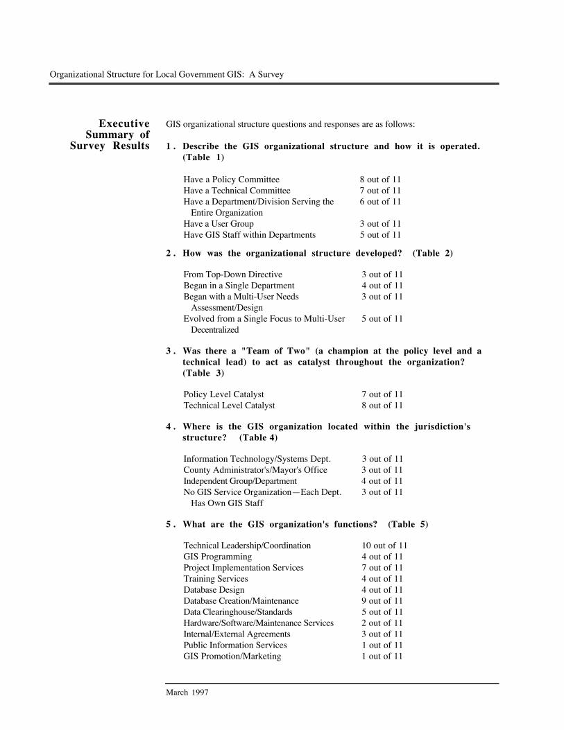
1 . Describe the GIS organizational structure and how it is operated.(Table 1)
Have a Policy Committee 8 out of 11Have a Technical Committee 7 out of 11Have a Department/Division Serving the
Entire Organization6 out of 11
Have a User Group 3 out of 11Have GIS Staff within Departments 5 out of 11
2 . How was the organizational structure developed? (Table 2)
From Top-Down Directive 3 out of 11Began in a Single Department 4 out of 11Began with a Multi-User Needs
Assessment/Design3 out of 11
Evolved from a Single Focus to Multi-UserDecentralized
5 out of 11
3 . Was there a "Team of Two" (a champion at the policy level and atechnical lead) to act as catalyst throughout the organization?(Table 3)
Policy Level Catalyst 7 out of 11Technical Level Catalyst 8 out of 11
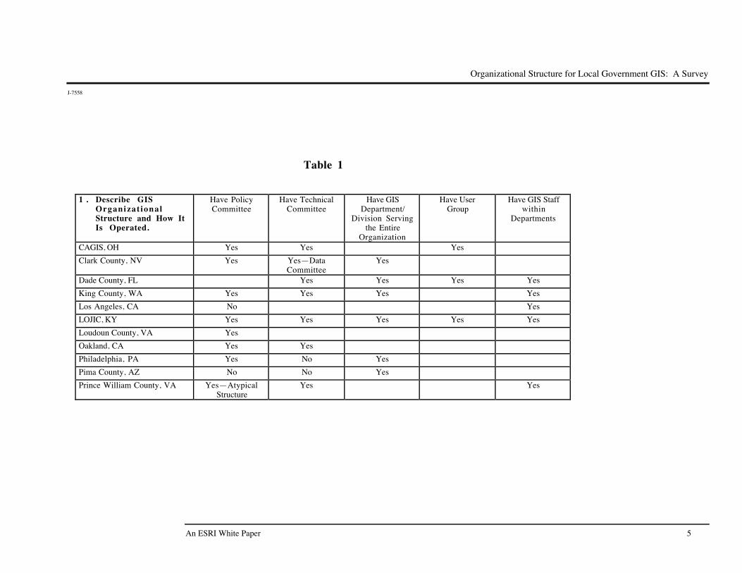
4 . Where is the GIS organization located within the jurisdiction'sstructure? (TableÊ4)
Information Technology/Systems Dept. 3 out of 11County Administrator's/Mayor's Office 3 out of 11Independent Group/Department 4 out of 11No GIS Service OrganizationÑEach Dept.
Has Own GIS Staff3 out of 11
5 . What are the GIS organization's functions? (Table 5)
Technical Leadership/Coordination 10 out of 11GIS Programming 4 out of 11Project Implementation Services 7 out of 11Training Services 4 out of 11Database Design 4 out of 11Database Creation/Maintenance 9 out of 11Data Clearinghouse/Standards 5 out of 11Hardware/Software/Maintenance Services 2 out of 11Internal/External Agreements 3 out of 11Public Information Services 1 out of 11GIS Promotion/Marketing 1 out of 11

Organizational Structure for Local Government GIS: A Survey
J-7558
An ESRI White Paper
6 . How are standards developed and enforced? (Table 6)
Developed by Consensus of UserDepartments
1 out of 11
Developed by GIS Organization 5 out of 11Enforced by GIS Organization 4 out of 11Developed/Enforced by Each User Department 2 out of 11Act as a Clearinghouse/Standards Promotion
Only3 out of 11
Enforced by Peer Pressure 2 out of 11
7 . Where has the organization succeeded in making GIS work?(Table 7)
Cost Recovery for Products/Data 1 out of 11Common Data Sharing (Road, Parcel,
Basemap Layers)5 out of 11
Providing Technical Assistance Services toUser Departments
2 out of 11
GIS Organization's Facilitator/CoordinatorRole
3 out of 11
Data Sharing Agreements with OutsideAgencies
3 out of 11
Staff Role Expansion 1 out of 11Strong Policy Committee 2 out of 11Standard Policies/Procedures 2 out of 11
8 . What have been the problems? (Table 8)
Magnitude of Effort Required To Move to anEnterprise System
4 out of 11
Quick Products vs. Well Planned Long-TermDatabase
1 out of 11
Finding/Using Successful Funding Strategies 5 out of 11Lack of Top-Down Support 3 out of 11Unsuccessful GIS Organizational Structure 3 out of 11Maintaining Qualified Staff 2 out of 11
9 . Is there an available diagram of the organizational structure, by-laws, or meeting minutes or other examples of how the organizationis run?
If this information was provided by the respondent, it is included in Appendix A.
1 0 . Describe the technical environment. (Table 9)
If this information was provided by the respondent, it is included in Appendix A.

Organizational Structure for Local Government GIS: A Survey
March 1997
1 1 . Describe how the organization deals with, or what role it playsregarding, the diversity of GIS and CAD software and the linkingand coordination of mainframe and legacy systems/data. Describehow the organization deals with interdepartmental rivalry forfunding, and so forth. (Table 10)
Standardized on Hardware/Software Products 1 out of 11Periodic Batch Upload/Download between
GIS and Mainframe5 out of 11
Encourage Use of Standards 6 out of 11No Interdepartmental Rivalry for Funding 4 out of 11Migrating Mainframe Databases to SQL
Client/Server Environments1 out of 11
ESRI wishes to thank the following organizations for their participation in the survey:
þ Clark County, Nevada þ Metro Dade County, Florida þ King County, Washington þ Loudoun County, Virginia þ Pima County, Arizona þ Prince William County, Virginia þ City of Los Angeles, California þ City of Philadelphia, Pennsylvania þ City of Oakland, California þ CAGIS (City of Cincinnati, County of Hamilton, Cincinnati Bell, and CG&E,
Ohio) þ LOJIC ([City of] Louisville [and] Jefferson County [Kentucky] Information
Consortium)
Organizational Structure for Local Government GIS: A Survey
J-7558
An ESRI White Paper 5
Table 1
1 . Describe GISOrganizat ionalStructure and How ItIs Operated.
Have PolicyCommittee
Have TechnicalCommittee
Have GISDepartment/
Division Servingthe Entire
Organization
Have UserGroup
Have GIS Staffwithin
Departments
CAGIS, OH Yes Yes Yes
Clark County, NV Yes YesÑDataCommittee
Yes
Dade County, FL Yes Yes Yes Yes
King County, WA Yes Yes Yes Yes
Los Angeles, CA No Yes
LOJIC, KY Yes Yes Yes Yes Yes
Loudoun County, VA Yes
Oakland, CA Yes Yes
Philadelphia, PA Yes No Yes
Pima County, AZ No No Yes
Prince William County, VA YesÑAtypicalStructure
Yes Yes

Organizational Structure for Local Government GIS: A Survey
J-7558
March 1997 6
Table 2
2 . How Was theOrganizat ionalStructureDeve loped?
From a Top-DownDirective
Began in a SingleDepartment
Began with a Multi-user Needs
Assessment/Design
Evolved fromSingle Focus to
Multi-userDecentralized
CAGIS, OH Yes
Clark County, NV Yes Yes
Dade County, FL Yes Yes
King County, WA Yes
Los Angeles, CA Yes
LOJIC, KY Yes
Loudoun County, VA Yes Yes
Oakland, CA Yes
Philadelphia, PA Yes
Pima County, AZ Yes
Prince William County, VA Yes Yes

Organizational Structure for Local Government GIS: A Survey
J-7558
An ESRI White Paper 7
Table 3
3 . Was There a Team of Two? Policy Level Catalyst Technical Level Catalyst
CAGIS, OH Yes Yes
Clark County, NV Yes
Dade County, FL No No
King County, WA
Los Angeles, CA Yes
LOJIC, KY Yes Yes
Loudoun County, VA Yes Yes
Oakland, CA Yes Yes
Philadelphia, PA Yes Yes
Pima County, AZ Yes Yes
Prince William County, VA Yes
Organizational Structure for Local Government GIS: A Survey
J-7558
March 1997 8
Table 4
4 . Where Is the GISOrganizat ionLocated within theJurisdict ion'sStructure?
InformationTechnology/
Systems Deptartment
CountyAdministrator's/Mayor's Office
Independent Group/Department
No GIS ServiceOrganizationÑEach
Department Has Own GIS
CAGIS, OH Yes
Clark County, NV Yes
Dade County, FL Yes
King County, WA Yes
Los Angeles, CA Yes
LOJIC, KY Yes
Loudoun County, VA Yes
Oakland, CA Yes
Philadelphia, PA YesÑCoordinationRole
Yes
Pima County, AZ Yes
Prince William County, VA Yes YesÑIn Process ofDecentralizing from IRM

Organizational Structure for Local Government GIS: A Survey
J-7558
An ESRI White Paper 9
Table 5
5. What Are theGISOrganization'sFunctions?
TechnicalLeadership/Coordination
GISProgramming
ProjectImplementation
Services
TrainingServices
DatabaseDesign
DatabaseCreation/
Maintenance
DataClearinghse/
Standards
Hardware/Software
MaintenanceServices
Internal/External
Agreements
PublicInformation
Services
GISPromotion/Marketing
CAGIS, OH Yes Yes Yes Yes Yes Yes
Clark County, NV Yes Yes Yes Yes
Dade County, FL Yes Yes Yes Yes Yes
King County, WA Yes Yes Yes Yes Yes Yes
Los Angeles, CA Yes
LOJIC, KY Yes Yes Yes Yes Yes Yes
Loudoun County, VA Yes Yes Yes Yes Yes Yes Yes Yes
Oakland, CA Yes Yes
Philadelphia, PA Yes Yes Yes
Pima County, AZ Yes Yes Yes Yes Yes
Prince WilliamCounty, VA
Yes Yes Yes Yes

Organizational Structure for Local Government GIS: A Survey
J-7558
March 1997 10
Table 6
6 . How Are StandardsDeveloped andEnforced?
Developed byConcensus of User
Departments
Developed by GISOrganization
Enforced by GISOrganization
Developed/Enforced by EachUser Department
Act asClearinghouse/
StandardsPromotion Only
Enforced by PeerPressure
CAGIS, OH Yes Yes
Clark County, NV Yes
Dade County, FL Yes Yes
King County, WA Yes Yes
Los Angeles, CA Yes Yes
LOJIC, KY Yes Yes
Loudoun County, VA Yes
Oakland, CA Yes
Philadelphia, PA Yes Yes
Pima County, AZ
Prince William County, VA Yes Yes

Organizational Structure for Local Government GIS: A Survey
J-7558
An ESRI White Paper 11
Table 7
7 . Where Has theOrganizat ionSucceeded inMaking GIS Work?
Cost Recoveryfor
Products/Data
Common DataSharing (Road,
Parcel,BasemapLayers)
ProvidingTechnicalAssistance
Services to UserDepartments
GISOrganization's
Facilitator/Coordinator
Role
Data SharingAgreementswith Outside
Agencies
Staff RoleExpansion
Strong PolicyCommittee
StandardPolicies/Procedures
CAGIS, OH
Clark County, NV Yes Yes
Dade County, FL Yes
King County, WA Yes Yes
Los Angeles, CA Yes
LOJIC, KY Yes Yes Yes Yes Yes
Loudoun County, VA Yes Yes
Oakland, CA Yes
Philadelphia, PA Yes
Pima County, AZ Yes
Prince William County, VA Yes Yes Yes

Organizational Structure for Local Government GIS: A Survey
J-7558
March 1997 12
Table 8
8 . What Have Beenthe Problems?
Magnitude of EffortRequired To Moveto an Enterprise
System
Quick Productsversus Well-Planned
Long-TermDatabase
Finding/UsingSuccessful Funding
Strategies
Lack of Top-DownSupport
Unsuccessful GISOrganizational
Structure
MaintainQualified Staffing
CAGIS, OH Yes
Clark County, NV Yes Yes
Dade County, FL Yes
King County, WA
Los Angeles, CA Yes Yes
LOJIC, KY Yes Yes
Loudoun County, VA Yes
Oakland, CA Yes Yes Yes
Philadelphia, PA Yes
Pima County, AZ Yes Yes Yes
Prince William County, VA Yes Yes

Organizational Structure for Local Government GIS: A Survey
J-7558
An ESRI White Paper 13
Table 9
1 0 . Describe theTechnica lEnvironment
Square Miles Population/Number of Parcels
LAN Servers/Workstations
PCS/X-emulation Estimated Numberof Users
CAGIS, OH 414 NR/370,000 7/20 50Ð400/8
Clark County, NV 75Ð100 50
Dade County, FL 2,000 2 Mil.+/450,000 7/NRÑinDepartments
NR/NR 58
King County, WA At Least One perDepartment/NR
250+/NR 250+
Los Angeles, CA 200Ð250 DesktopUsers/30
Workstation Users
LOJIC, KY 390 625,000/260,000 4/68 400/10 200 DesktopUsers/125
Workstation Users
Loudoun County, VA 520 119,000/NR 1 31
Oakland, CA 250+ Desktop Users
Philadelphia, PA 136 5 Mil./700,000 3/15 3,000
Pima County, AZ 20 WorkstationUsers/50 Desktop
Users
Prince William County, VA 1/Some NR Numerous/Numerous
NR = No Response

Organizational Structure for Local Government GIS: A Survey
J-7558
March 1997 14
Table 10
1 1 . IssuesÑGIS/CAD,Mainframe/Legacy Systems,InterdepartmentalR i v a l r y
Standardized onHardware/ Software
Products
Periodic BatchUpload/Downloadof Data between
GIS and Mainframe
Encourage Use ofStandards
NoInterdepartmental
Rivalry for Funding
MigratingMainframe
Databases to SQLClient/ServerEnvironments
CAGIS, OH Yes
Clark County, NV Yes Yes
Dade County, FL Yes Yes
King County, WA Yes Yes
Los Angeles, CA Yes
LOJIC, KY Yes Yes
Loudoun County, VA Yes
Oakland, CA Yes
Philadelphia, PA Yes Yes Yes
Pima County, AZ Yes
Prince William County, VA Yes
J-7558
An ESRI White Paper
Key Findings Eleven responses to the survey were provided by six counties, three cities, and twoconsortiums. Each of the respondents also involves external user organizations in itsshared GIS. Characteristics of the respondents' size are
þ Population Served = 120,000Ð5,000,000þ Number of Parcels = 260,000Ð1,000,000þ Square Miles Covered = 100Ð2,000
Several have been in operation for five to ten yearsÑin on the ground floor of GIS, so tospeak. Their early years were focused on database development (i.e., basic shared datalayersÑbasemaps, parcels, and centerlines with addresses) and project/specific application-oriented implementation. This required a fairly substantial investment in staffÑtrainingthem to learn GIS software, data automation, geographic analysis methods, cartographicproduction, information management techniques, and a host of other skills not normallydeveloped/utilized in the local government arena.
The respondents are now in a shift-focus mode, prompted in large part by the movementof the hardware/software to the desktop. Certain elements are receiving more attention(e.g., serving larger numbers of users with some relatively simple display and queryneeds), and good organizational structures are solidifying and growing as shared databaseshave become commonly available.
Along the way, through the ups and downs of building a GIS, the respondents amassed afairly substantial amount of experience and insight about how to best reorganize humanresources to employ the new technology toward old concepts (i.e., providing improvedcommunity services more efficiently to residents/taxpayers). They've done much of thegroundwork for defining organizational strategies that will support a successful GIS in alarge government organization environment. The following summarizes their appraisal ofwhat works and doesn't, and why.
GIS Committees andTechnical Support
Staff
Ten of the eleven respondents identified an organizational structure with some variationof the following components: policy committee, technical committee, user group, anda GIS technical support staff for the enterprise. In all cases this structure supports adistributed GIS with shared data. Figure 1 illustrates a common form of thisorganizational structure.
1 . Steering or Policy Committee
It is important to have a steering committee that is actively involved in the decisionmaking process, providing leadership and direction in the organization's GISdevelopment. Executive level support and the support of political appointees isparticularly important in large GIS organizations. In the absence of a steeringcommittee with decision making power, the GIS agency/department is forced to takeon more of a coordination/education/marketing role. This makes GISimplementation much more fragmented and slower.

Organizational Structure for Local Government GIS: A Survey
J-7558
March 1997
Figure 1
POLICY/STEERING
COMMITTEE
GISMANAGER/
COORDINATOR
GISSERVICES
STAFF
GISTECHNICALCOMMITTEE
DEPT./AGENCYGIS
COORDINATORS
CITY/COUNTY DEPARTMENTS/AGENCIES
Common GIS Organizational StructureFor Local Government

Organizational Structure for Local Government GIS: A Survey
J-7558
An ESRI White Paper
The steering committee's composition is often department heads and top-leveladministrators, or their designated representative, from participating departments,cities, and organizations. Some local government GIS enterprises have incorporatedother entities, such as utility companies, into the GIS and steering committeestructure. Regular meetings are held monthly or quarterly, as established by thecommittee.
Responsibilities of the steering committee generally include the following:
þ Status reviewþ General oversightþ Policy formulationþ Finance and budget decisionsþ Growth and expansion of participant baseþ Approval of special license agreementsþ Product pricingþ Provide direction to the GIS Department
2 . Technical Committee
The technical committee can serve as a means of interdepartmental/interagencycommunication and cooperation. It is generally composed of the technical leadperson from each participating department (i.e., the GIS software "power" user fordatabase or application development or the system administrator). Regular meetingsare held monthly or quarterly, as established by the committee.
Responsibilities of the technical committee generally include the following:
þ Provide technical direction.þ Recommend projects and studies.þ Recommend database/application development.þ Address system integration/expansion issues.þ Conduct user training.þ Determine product policies.
3 . User Groups
User groups provide an open forum for all GIS users. GIS implementation ismultifaceted. It supports many different types of daily functions, interfaces withmany other systems, operation on many different platforms, and support for a vastrange of simple to very complex analyses. GIS implementation must also keep pacewith rapid technology change and therefore requires continued attention to providingusers with educational information and tips. From the opposite perspective, GISimplementation requires a means for users to provide their system support staff withinput on how best to serve their needs. A user group serves these functions well.This element will probably continue to grow in importance in the organizationalsupport of GIS because of the movement of technology to the desktop.

Organizational Structure for Local Government GIS: A Survey
J-7558
March 1997
Most user groups have no official responsibility and no budget, but may be consultedby steering and technical committees for input into decision making about GISexpenditures for data, applications, and systems.
User group meetings may include presentations and discussions to address data,applications, systems, resources, and other issues of importance to users.
4 . GIS Manager and Staff for the Enterprise (GIS Services Department)
The GIS services staff provide technical and database services for the shared systemand usually report to the policy/technical committees. GIS services staff for theenterprise can be its own department, or a part of the city/county managementinformation services department, or under the city/county administrator. It can alsobe part of one participating department, if that department has taken the lead in GISimplementation with the expressed intent of migrating it to a full consortium overtime.
In the larger GIS enterprises, GIS services staff usually number ten to fifteen personsheaded by a GIS manager/coordinator. Staff may consist of a combination of GISanalysts, GIS applications programmers, system administrators, hardware/softwaretechnical support specialists, and trainers.
Responsibilities of GIS support staff generally include the following:
þ Provide technical leadership to participants.þ Perform GIS programming, also integrated services programming.þ Provide project implementation services.þ Provide training services.þ Perform database design.þ Provide maintenance for the core central data layers.þ Perform database maintenance.þ Provide technical coordination for departments.þ Provide technical support services to user departments.þ Develop and enforce standards.
5 . Departmental GIS Managers and Staff
Departmental GIS staff provide technical and database services for the department'sfunctions. Departmental staff may be composed of a departmental GISmanager/coordinator and technical staff with database maintenance, applicationsprogramming, and system administration skills.
Responsibilities of departmental GIS staff may include the following:
þ Provide technical support services to departmental users.þ Define and program departmental GIS applications.þ Implement departmental GIS projects.þ Provide maintenance for departmental data sets.

Organizational Structure for Local Government GIS: A Survey
J-7558
An ESRI White Paper
Top-Down Leadership A key success factor noted by several organizations responding to the survey was top-down direction/leadership for GIS implementation. A top-down directive, coupled with athorough design process (needs assessment and realistic implementation plan) and fundingsecured to implement as planned, provides a high probability of successful GISdevelopment and growth.
This approach can be done with one agency taking the lead, as exemplified by theMetropolitan Sewer District (MSD) with the Louisville and Jefferson County InformationConsortium (LOJIC). The agency should plan for co-ownership with other participantsover time, with dissemination/decentralization/sharing in cost and management(e.g.,Êform a consortium) and with lease/purchase agreements over a ten-year period.
GIS Champion A GIS champion at the policy level can act as a catalyst for funding support. Surveyresults show that having a GIS champion at the executive level is important both inobtaining a political support base and in convincing management of the benefit ofproceeding with GIS implementation. Several factors contribute to the need for a GISchampion to educate and motivate government leaders: the enterprise nature of GIS, itsmultidimensional composition (the five parts of a GIS), and the fact that it provides theimpetus for a change in the way government does business. The GIS champion shouldbe one who can help establish funding mechanisms and agreements, for example, throughsome combination of general funds, development/internal services, data sales, andlicenses.
Technical Standards The development and enforcement of standards, primarily for data but also forsoftware/hardware, is a major support mechanism in a successful GIS organizationalstructure. The need for and use of GIS standards in local government operations havegrown in importance with the evolution toward the enterprise environment. In earlieryears there were no, or limited, standards governing data development or systemintegration. Today there is greater reliance on standards, as more data are developed andshared in the enterprise and more users are added. A user's own data, however, are notnecessarily subject to these standards.
In most cases, standards have been developed by the GIS support services agency,sometimes in cooperation with user departments. "Enforcement" of standards has alsobeen done successfully by the GIS agency on a variety of levels.
On an informal level, data standards can be enforced by requiring on-line metadatadocumentation of the quality and heritage of data. This approach allows the users todecide whether the available data can be used for their own purposes. Data standards canalso be enforced informally by peer pressure from user departments or by encouragementor guidance from the GIS agency.
On a more formal basis, data standards can be enforced by having the GIS agency performquality control checking of departmental data sets before they can be published to thegeneral database server or distributed by other means to the enterprise participants. Datastandards can also be enforced by increasing service costs to any user not followingestablished standards, or by denying access to the shared database to users who do notfollow standards in their own data production.

Organizational Structure for Local Government GIS: A Survey
J-7558
March 1997
GIS StaffDevelopment
Focusing on GIS staff growth, that is, developing and retaining GIS staff, particularly forthe GIS support services agency, is another key element in organizational strength andviability. This involves supporting continued staff training, expanding staff roles, andincreasing compensation levels to keep pace with staff growth and to rival pay scalesfound in the GIS marketplace.
System Integration Survey respondents have found that the GIS support services agency functions well in alead role in integrating GIS with other systems (i.e., GIS links to legacy data, CADsystems, and imaging systems). The steering committee may be instrumental inidentifying priorities for system linkages, but determining the mechanics foraccomplishing those linkages is best invested with the GIS support services agency. TheGIS agency can provide technical expertise in defining a data exchange strategy and dataexchange protocols and procedures. Up to this point, most government GISorganizations surveyed have addressed mainframe/GIS data linkages by establishing aregular download routine rather than an interactive link.
Departmental use of independent, nonconforming databases, software, and hardware canresult in technology bottlenecks costing time and money. The GIS support servicesagency can be instrumental in setting standards for data format, software, and hardware forthe enterprise system. For example, standards seem to govern the GIS/CAD dataexchange arena in most of the government GIS organizations surveyed.
Common Spatial Data Common spatial data needs can provide a catalyst for interagency cooperation andteamwork, thus changing old ways of doing business. The sharing of spatial data fostersa team approach to problem solving. Spatial data can be used as the vehicle forintegrating major systems under revamp/development (i.e., E-911/GIS integration).
Unified Approach The GIS organizational structure must be built with a comprehensive understanding of thebreadth and complexity of successful enterprise GIS implementation. It must set realisticgoals, clarify user needs, develop an implementation strategy that serves to meet theseneeds, share implementation tasks/costs, and focus on steady progress toward goals.
Several respondents noted that what doesn't work is an unfocused, disunited approach toGIS development, in which a few are saddled with all the development costs. GIS shouldbe built as a distributed system, with other departments buying into and co-owning theenterprise. Some survey results indicated that GIS was established by two/threedepartments/agencies who were very proactive with GIS because they foresaw highpotential benefits for supporting/improving their own operations. Thus they initiallycommitted to a disproportionate share of the cost of database/system development. If overtime, however, they don't see that others joining in to use the system are contributingequitably to its continued funding, resentment can build and the supporting organizationalstructure break down (i.e., funds are shifted away from GIS).
Several of those surveyed indicated that the GIS evolved from one department initiallystarting it up to serve its own needs. This was an operations/development focuseddepartment (e.g., a planning department, environmental management department, publicworks department), not the centrally focused MIS or city administrative office. Placingthe GIS support staff within an operations/development focused department doesn't workwell for evolving into an enterprise environment where other departments contribute tothe funding support of the GIS operation. The department's single focus and prioritiesmake it "nonneutral territory."
Organizational Structure for Local Government GIS: A Survey
J-7558
An ESRI White Paper
Appendix A
QuestionnaireResponses
Responses have been included for those agencies from which permission was receivedprior to printing of this white paper.


Organizational Structure for Local Government GIS: A Survey
J-7558
March 1997
Clark County, Nevada
1 . Describe the GIS organizational structure and how it is operated.
The Geographic Information Systems Management Office (GISMO) is a separateCounty department with responsibility and authority for County-wide GIS resourcedevelopment. The GISMO is also responsible for regional coordination. Multipleagencies throughout southern Nevada participate through interlocal agreements. Theprogram is coordinated by a two-tiered committee structure: a policy committee,with three agency representatives, that establishes funding participation anddevelopment priorities; and a data committee, consisting of technical staff, that meetsonce per month on issues of status, standards, and data sharing.
2 . How was the organizational structure developed?
In 1980, the Planning Department became ESRI site number 14. The first projectwas based on automated mapping with no other related data or system administrationuntil 1986. Other departments then started to request services. A top-down mandatecame from the progressive County manager, who wanted a multidisciplinary GIS,flexible enough to work with other agencies in the Southern Nevada region.
This involved a pilot, an implementation plan done by a consultant whorecommended a central coordinating body, a separate entity from the MIS or otherdepartments. It was very successful.
3 . Was there a "Team of Two" (a champion at the policy level and atechnical lead) to act as catalyst throughout the organization?
The County manager's assistant was the chair of the pilot committee. He continuedto chair it until the implementation plan was developed, championed through hiringthe GIS manager.
4 . Where is the GIS organization located within the jurisdiction'sstructure?
While the GISMO acts as a separate department, it is actually a division of themanager's office. It reports to the assistant County manager in charge ofdevelopment or service activities.
There is a great deal of support in the manager's office, which is interested in usingimproved technology to save resources and dollars. The MIT Department wasunprepared; its expertise lies with different tools that are more accounting related.
Organizational Structure for Local Government GIS: A Survey
J-7558
An ESRI White Paper
5 . What are the GIS organization's functions?
The GISMO has three mission components:
1. County-wide GIS resource development
2. Regional coordination and implementation support
3. The 911 emergency response street file for the entire Clark County arearegardless of jurisdiction
From a regional coordination perspective, the GIS manager has twelve bosses:internal County departments plus dealing at the midexecutive level to facilitateresource sharing within agencies and departments and buy-ins.
þ Policy functions = external: agency directors, interlocal agreements to fostershared development throughout southern Nevada
þ Technical functions = internal: technical aspects, staff representatives from
departments, good system development
6 . How are standards developed and enforced?
The main role of the department is to develop and enforce standards by acting as aclearinghouse for GIS data (repository), documentation, metadata, truth in labeling(quality rating), and telecommunications access. Individual users make the decisionon whether they can use the data "as is" for their own purpose. The department's roleis to ensure that users understand the content, quality, and applicability of the datathey are receiving.
Internal cartographic standards are set and followed. These serve to convey a standardlook and feel for all County maps, and the standard format/design makes systemnavigation and use easier.
7 . Where has the organization succeeded in making GIS work?
GIS is used in many County departments including the Assessor, Planning, PublicWorks, Building Department, Police, Fire, Parks, Elections, EmergencyManagement, executive decision makers, and others.
The Assessor uses GIS to support the volume of growth that equals an average ofthirty new subdivisions per month, with fifty last month.
All conversion is based on survey control. Parcels and streets are orthophoto-derivedand maintained with survey data.
Street centerlines are used as the basis for election districts and precincts.

Organizational Structure for Local Government GIS: A Survey
J-7558
March 1997
A key incentive for users is the control based data, which allows the departments tofocus on how to project features on the basemaps rather than on registration issues.This promotes coordination.
8 . What have been the problems?
þ Should have expedited the street centerline conversion process. Would havecreated street centerlines earlier to support any and all address-related analysissuch as pavement, E-911, and so forth.
þ Constant debate over trying to please management with quick products versus
well-defined and planned long-term database. þ Dollars versus executive support
9 . Is there an available diagram of the organizational structure, bylaws,or meeting minutes or other examples of how the organization isrun?
See Figure 2.
1 0 . Describe the technical environment.
There are 75Ð100 DEC Alpha servers, with ArcView GIS on approximately fiftyPCs, stand-alone and networked. We are currently implementing Oracle.
1 1 . Describe how the organization deals with, or what role it playsregarding, the diversity of GIS and CAD software, and the linkingand coordination of mainframe and legacy systems/data. Describehow the organization deals with interdepartmental rivalry forfunding, and so forth.
Many mainframe applications, such as assessor's tabular data, are extracted nightly topopulate the GIS files. This process is very effective. If captured originally on GIS,the reverse occurs, and land use codes are extracted to populate the tabular side.
CAD data come in from developers. GISMO converts it using the DXFARCcommand and provides DXF to the development community. ARC/INFO andArcCAD are major software components.
There is competition between departments for funding. An extra rating is obtainedwith the County if your department can enhance the operation of multipledepartments. GISMO always rates high because of this. Funding is offset by datasales.

Organizational Structure for Local Government GIS: A Survey
J-7558
An ESRI White Paper
Figure 2
GISDIRECTOR
DATABASEADMINISTRATION
DATACONVERSION
Mission GISMO develops and coordinates the County-wide use of geographic informationsystem resources to ensure their efficient use and to maximize public benefits.
Description GISMO coordinates the acquisition, use, exchange, and dissemination of geographicinformation between departments and local entities. Through interlocal agreements andgrant funding, governmental entities agree to pay for GIS services and administration.GISMO facilitates communication through meetings, local conferences, and newslettersto ensure that all GIS data users are informed and trained on systems capabilities.
GISMO monitors and administers GIS resource usage and enforces standards, useragreements, and contracts. GISMO develops and promulgates standards for dataacquisition, data quality, formats, application integration, and maintenance related togeographic information. GISMO has in-house data conversion expertise to assist userswith the planning and implementation of resources that cannot be contracted or otherwiseconverted. In addition, GISMO maintains the Emergency Response 9-1-1 dispatch basefile.
Organizational Structure for Local Government GIS: A Survey
J-7558
March 1997
Metropolitan Dade County,Florida
1 . Describe the GIS organizational structure and how it is operated.
The Information Technology Department (IT Department) has managed the County'sGIS infrastructure since 1987 including central hardware and software and productiondata. There is a GIS Technical Support Group (staff of 16) within the Departmentthat administers the system, provides technical support to the application developers,establishes standards, performs research and development tasks, and determines futurestrategies. The IT Department provides data on request and GIS services on anadÊhoc basis. The central system currently has around twelve departments using itdirectly; another twelve plus departments download data or place ad hoc requests.
Individual departmentsÑPolice, Fire, Property Appraiser, and so forthÑobtainapplication services from the IT Department or they hire their own technical staff tobuild applications using ARC/INFO¨ or ArcView¨ GIS software. Although mostusers use the central GIS platform, some departments own their own workstations,servers, and so forth. The Technical Support Group encourages GIS developers fromall County departments to share their data by providing a copy of all coverages and/ortables that they create. These data are then available from the central host machinesor other data servers. For the most part, the County has kept the ESRI product lineas the standard.
A County-wide GIS User Group was formed in 1994. The group meets quarterly,while more technical meetings for the applications developers are held on the offmonths. The Office of Management and Budget has often requested the user group toapprove GIS expenditures.
Although there are now twenty-nine different municipalities in Dade County, noformal intergovernmental agreement exists. Data, technical support, and technologytransfer is done in an informal manner.
2 . How was the organizational structure developed?
There were a number of departments that were interested in the technology andprovided "seed" money for the initial purchase; however, the implementation wasdesigned and coordinated by the Information Technology Department. After theinitial implementation with only a street network as the basemap, a number of yearswere spent "selling" the technology throughout the County in order to obtain fundsfor a parcel basemap and the continued growth of the infrastructure.
Organizational Structure for Local Government GIS: A Survey
J-7558
An ESRI White Paper
3 . Was there a "Team of Two" (a champion at the policy level and atechnical lead) to act as catalyst throughout the organization?
Not really, since no formal policy was established in the beginning.
4 . Where is the GIS organization located within the jurisdiction'sstructure?
GIS is located in the IT Department. Yes, it has always been located here. The ITDepartment was already the central location for many of the County's databases andhoused the technical staff required to implement the new technology.
5 . What are the GIS organization's functions?
As described in number 1, the IT Department's primary objective is to provide areliable GIS infrastructure. A key component of that is supporting the applicationsfor the maintenance of the basemap layers and, in some cases, maintaining the layersas well.
6 . How are standards developed and enforced?
Standards are just now being established in a more formal fashion after many years ofinformally setting them. Since the IT Department has not been given the power ofenforcement, we can only encourage the user departments to follow them to gain themost from the system.
7 . Where has the organization succeeded in making GIS work?
Having a centralized system that has been available to any department needing GISservices has been the key to its success. The GIS User Group has helped a great dealto spread the knowledge and introduce GIS tools to other departments.
8 . What have been the problems?
Funding the GIS infrastructure has been a major problem from the beginning. TheOffice of Management and Budget does not include it in the "general fund." Instead,certain enterprise departments, such as Environmental Resources Management, Waterand Sewer, Solid Waste, and Zoning, are required to pay for a majority of the costs,with the Information Technology Department covering the rest. Placing the financialburden on just a few departments introduces budgeting problems for them as well.
9 . Is there an available diagram of the organizational structure, by-laws, or meeting minutes, or other examples of how theorganization is run?
No response.

Organizational Structure for Local Government GIS: A Survey
J-7558
March 1997
1 0 . Describe the technical environment.
þ Dade County, Florida
¥ Population: 2,000,000+¥ Square Miles: 2,000¥ Street Network: 97,000 Arcs¥ Parcels: 450,000 (Information for 300,000 related condos through tables)
Below lists the hardware/software at the IT Department only. There are otherworkstations and servers available at some of the other departments.
þ Two primary nodesÑone development and the other production.þ DEC 7620sþ Digital UNIXþ GB memory eachþ Approximately 25 GB on each machineþ DevelopmentÑ18 concurrent usersþ ProductionÑ40 concurrent usersþ SDE ServerÑAlphaServer 2100 4/275
IT Department has four other DEC workstations used for testing and CPU intensivetasks.
Near Future: AlphaServers for Internet applications and distributed data forMapObjectsª and ArcView GIS software use.
1 1 . Describe how the organization deals with, or what role it playsregarding, the diversity of GIS and CAD software, and the linkingand coordination of mainframe and legacy systems/data. Describehow the organization deals with interdepartmental rivalry forfunding, and so forth.
As mentioned before, the IT Department encourages the user departments to use theESRI¨ product line; not only for data format reasons, but also for better resourceuseÑthat is, knowledgeable staff to provide technical assistance and the ability to getvolume discounts for software. Part of the County's objectives for improvinginformation technology throughout the County is the establishment of standards.This includes the GIS software and data.
A number of methods for using legacy/mainframe data were researched early on. Thebest way we have found is to extract the most commonly used data into INFO on aweekly basis. For most applications, this frequency is adequate. There are currentlyno applications with real-time access to mainframe data. There are nightly updates ofcertain files on the mainframe from data provided from the GIS.
Currently there is access to external RDB and Oracle databases, although limited.The IT Department is trying to set Oracle as the standard for external databasemanagement systems.


Organizational Structure for Local Government GIS: A Survey
J-7558
An ESRI White Paper
King County, Washington
1 . Describe the GIS organizational structure and how it is operated.
GIS oversight committeeÑTo provide leadership; promote, plan, direct, andcoordinate development and implementation of a County-wide geographicinformation system.
Capital project subcommitteeÑTo monitor the schedule, budget, and status of theGIS Capital Project; to resolve conflicts in the project scope or schedule in a mannerthat best serves the business needs of Metropolitan King County; and to report onthe progress of the capital project to the GIS oversight committee.
GIS technical subcommitteeÑTo advise the GIS oversight committee on technicalmatters arising from the development of a geographic information system forMetropolitan King County including the recommendation of standards, the review ofdata specifications within the capital project, the review of data maintenanceagreements, and the review of the technical specifications for the infrastructuredeveloped during the capital project. Recommendations from the GIS TechnicalSubcommittee will be forwarded to the capital project subcommittee for presentationto the GIS oversight committee.
GIS program managerÑServe as primary contact for all King County departmentsinvolved in GISs. Manage the implementation of the King County GIS TechnicalResource Center. Establish objectives, develop workplan, and monitor budget for theproject, in addition to coordinating the subprojects.
2 . How was the organizational structure developed?
The organizational structure was developed about 3.5 years ago. With support fromthe King County Council, Metropolitan Services coordinated with King Countydepartments to utilize GIS as a business function approach and establish the goals ofthe King County GIS Technical Resource Center Project that includes dataacquisition, data conversion, network construction, hardware and software acquisition,negotiation of maintenance contracts, and related support functions. The KingCounty GIS Technical Resource Center Project was comprised of four subprojects:the establishment of geodetic control, the development of parcel and related datalayers, the development of the street network and related data layers, and theacquisition and installation of the infrastructure to make the data accessible to theparticipating agencies. In addition, the King County GIS Technical Resource CenterProject was given direction to build the organizational commitment to maintain andenhance the geographic information created by this project. The officials andorganizations participating in the King County GIS Core Project at the time ofsigning this charter include the King County Council, the King County Assessor,and the departments of Executive Administration; Metropolitan Services; Public
Organizational Structure for Local Government GIS: A Survey
J-7558
March 1997
Works; Public Health; Parks, Planning, and Resources; Public Safety; Developmentand Environmental Services; and the Office of Financial Management.
3 . Was there a "Team of Two" (a champion at the policy level and atechnical lead) to act as catalyst throughout the organization?
Metropolitan Services and Development and Environmental Services provided theimpetus for GIS to spread throughout the County.
4 . Where is the GIS organization located within the jurisdiction'sstructure?
There is an independent group called the Technical Resources Center (TRC) withinthe Information and Telecommunication Service Division. It has been in existence alittle over three years. TRC has migrated from a capital project to Operational Groupfunded, paid by participating departments.
5 . What are the GIS organization's functions?
The Technical Resources Center is a clearinghouse for all County GIS data. Itprovides capital project and technical leadership for all County GIS activities,provides hardware/software technical support/leadership for all the departments,provides training, evaluates new software/hardware products, does hardware/softwaremaintenance, and provides a core central database for the fourteen departments. Thisincludes maintenance of several data layers including parcels.
6 . How are standards developed and enforced?
The Technical Resources Center has developed written standards for system, database,and programming. The Center checks department sites for these standards andenforces them through increasing service costs to departments that do not follow thestandards.
7 . Where has the organization succeeded in making GIS work?
Departments have been assigned individual coverages to maintain, thus stopping theduplication of coverages. For example, street centerlines were being maintained byseveral departments and now one does it.
Departments' awareness has increased regarding the need for and utility of standards,thus increasing their compliance with them.
Organization has been responsive to directives from top down to help smalldepartments.
Small departments are provided assistance from introduction-to-GIS level throughfull-scale GIS deployment.
Organizational Structure for Local Government GIS: A Survey
J-7558
An ESRI White Paper
8 . What have been the problems?
No response.
9 . Is there an available diagram of the organizational structure, bylaws,or meeting minutes or other examples of how the organization isrun?
No response.
1 0 . Describe the technical environment.
In the Technical Resources Center there is DEC Alpha OSF 3/4, with mostly PCswith X emulation. In the other County departments, there is a mixture of UNIXplatforms including HewlettÐPackard and Sun. Up to now, the Center has primarilybeen a workstation ARC/INFO user environment, but now it is beginning to dealwith large numbers of ArcView GIS users (e.g., the Assessor is getting 250 ArcViewGIS licenses). The Center is currently evaluating options such as Spatial DatabaseEngineª (SDEª) to provide easy accessibility to the desktop user.
1 1 . Describe how the organization deals with, or what role it playsregarding, the diversity of GIS and CAD software, and the linkingand coordination of mainframe and legacy systems/data. Describehow the organization deals with interdepartmental rivalry forfunding, and so forth.
GIS-CAD approach of the Center has been to support DXF-to-ARC/INFO andARC/INFO-to-DXF conversions, but to try to keep AutoCAD licenses to aminimum. The Center is setting up a standard now for engineers to use insubmitting CAD data to the County. All County mainframe databases are/will bemigrated to standard Structured Query Language (SQL) client/server environments(Oracle, Informix, Sybase).


Organizational Structure for Local Government GIS: A Survey
J-7558
March 1997
LOJIC (City of Louisville andJefferson County, KentuckyInformation Consortium)
1 . Describe the GIS organizational structure and how it is operated.
LOJIC has a policy committee (meets every other month), chaired by the executivedirector of Louisville and Jefferson County Metropolitan Sewer District (MSD). Thecommittee is comprised of top level administrators from each of the LOJICparticipantsÑMSD, Property Valuation Administrator, City of Louisville, JeffersonCounty, and Louisville Water Company. It is responsible for general oversight andformulation of policies regarding the broad goals of LOJIC; growth and expansion ofparticipant base; approval of special license agreements; funding of special projects,studies, research, and additions to GIS staff; open records policies; and productspricing.
There is an LOJIC technical committee (meets monthly) comprised of fourteenLOJIC users from the following participating agencies:
þ MSD Storm Water, Sanitary Planning, Information Servicesþ PVA Property Mappingþ Planning Commissionþ City Public Worksþ County Public Worksþ Louisville Water Companyþ City Information Servicesþ County Information Servicesþ City Inspections/Permits/Licensesþ LOJIC Technical Staff
The technical committee serves as a means of fostering interagency communicationand cooperation in many areas of LOJIC implementation. The membership providesgeneral technical direction in recommending priority projects and studies,database/application development, resource allocation and the expansion of LOJIC toother user agencies. The technical committee may assemble ad hoc subcommitteesfor purposes of conducting special studies resulting in reports and recommendationsto the technical committee and policy committee. The technical committee has dealtwith issues on system integration/expansion, database updates, applicationdevelopment, site addresses, survey control enhancement, development plan review,user training, and products policies.
The LOJIC User Group (meets every other month) is an open forum of all LOJICusers and involves presentations and discussions on system enhancements, software
Organizational Structure for Local Government GIS: A Survey
J-7558
An ESRI White Paper
developments, new data and applications, special projects, technical instruction, andany other issues of importance to LOJIC users.
A twelve-person technical staff for LOJIC, housed in MSD Engineering, and fundedthrough MSD, supports GIS activities in the user agencies. This staff is made up ofthree teams: database development, applications development, and systemmanagement. Through an extensive LOJIC user support program (LUSP), thesestaff support all user agencies and guide the integration and use of the LOJIC GIS.
2 . How was the organizational structure developed?
In 1985, PlanGraphics was commissioned to study the feasibility and cost-effectiveness of a comprehensive GIS for the City of Louisville, Jefferson County,the Metropolitan Sewer District, and the Property Valuation Administrator. Aconsortium was formed to implement the GIS and to facilitate the participation ofother agencies and utilities. There are now twenty-seven agencies among the fourmajor participants including agencies from the City of Louisville, Jefferson CountyGovernment, the Property Valuation Administrator, Louisville Water Company, andthe Metropolitan Sewer District.
MSD provided the capital and staff for initial LOJIC developmentÑcore data,systems, staff, and applications. "Lease/Purchase" agreements have been developedwith the City of Louisville, Jefferson County, Louisville Water Company, andPVA, who over a fifteen-year time frame will provide payments to MSD for LOJICcoownership. Annual payment of City and County is $250,000 each. At the fifteen-year end, LOJIC will be co-owned by MSD at 30 percent, PVA at 10 percent,Louisville Water Company at 20Êpercent, City of Louisville at 20Êpercent, andJefferson County at 20Êpercent.
The Louisville Water Company recently agreed to join the consortium as a fullparticipant. The Louisville Gas and Electric Company has renewed discussions tolicense LOJIC basemapping. The Consortium is also negotiating limited licenseagreements with other small municipalities and independent fire protectiondepartments in Jefferson County. Cooperative relationships exist with theUniversity of Louisville for training, internships, and research support. Ongoingdiscussions with the Louisville Chamber of Commerce and other private sectorbusinesses and data developers guide marketing and product direction.
3 . Was there a "Team of Two" (a champion at the policy level and atechnical lead) to act as catalyst throughout the organization?
Policy level champion has been the MSD Executive Director Gordon Garner, andtechnical level champion has been MSD LOJIC Manager Bruce Seigle.
Organizational Structure for Local Government GIS: A Survey
J-7558
March 1997
4 . Where is the GIS organization located within the jurisdiction'sstructure?
MSD serves as the project management agency for the Consortium. LOJIC staff arein MSD, which funded the initial implementation of the system at the approval ofthe MSD Board. While LOJIC staff are housed in MSD, their function is to serveLOJIC participantsÑto build, maintain, enhance, and support GIS use throughoutthe Consortium. An LOJIC staff of twelve includes one network administrator, onehardware specialist, six applications developers/GIS analysts, one databasecoordinator, one technical coordinator, one product specialist, one technician, and oneGIS manager.
5 . What are the GIS organization's functions?
Provide technical support services, training, standards, policy/procedure guidelines,maintain shared data libraries, encourage users to publish data, and develop metadatastandards.
6 . How are standards developed and enforced?
They were developed by LOJIC staff. Only metadata standards are enforced for datapublished by users. LOJIC staff provide guidance and support to users developingtheir own data.
Metadata and system documentation are now available on-line to all LOJIC users.While not yet totally FGDC compliant, this documentation is patterned after theNational Spatial Data Standard, and provides consistent and highly detailedinformation on the characteristics, sources descriptions, maintenance status, point ofcontact, and schema dictionaries for each of the 100 published LOJIC GIS databases.
7 . Where has the organization succeeded in making GIS work? Howhas the GIS organization been able to promote GIS in departmentsor throughout the government?
LOJIC played a major role in changing the Kentucky Open Records Law to allowcost recovery for GIS products and data, based on either the commercial ornoncommercial use of the data. LOJIC has recovered over $500,000 in the past fouryears through the sale of products and services. Policies in place coordinate productdistribution and fee schedules among all participant agencies.
Users share a common geographic database of planimetric/topographic features,property, administrative/political boundaries, natural resources, street centerlines, andaddresses, eliminating redundant mapping. Individual agencies have maintenanceresponsibilities for each shared LOJIC database.
Increased cooperation and communication among governmental agencies, especiallyin the area of network and systems development. Because of the success of theLOJIC Consortium, initiatives have begun over the last eighteen months to developa joint fiber optic network connecting the agencies of City, County, and State

Organizational Structure for Local Government GIS: A Survey
J-7558
An ESRI White Paper
government and the office sites of MSD, Louisville Water Company, and manyschools within the urban area.
LOJIC is facilitating the development of a joint E-911 system among numerousCity, County, and District organizations involved in emergency management. Thisis being done by providing a common denominator, spatial dataÑsite addresses,specificallyÑfor joint use by all in a shared system.
LOJIC's approach to GIS (as a toolÑa technical bridge solutionÑnot imposed fromabove) and its assumed role as a facilitator, behind the scenesÑthese have promotedinteragency cooperation and view of the benefits of the system for improving jobefficiency.
As LOJIC developed and grew in scope and magnitude, staff roles were expanded andredefined to accommodate and promote the growth. MSD has supported the staffposition redefinition/role expansion and compensation upgrades needed to:(1)Êacknowledge professional growth to more complex duties and responsibilities,(2)Êretain trained/qualified staff, and (3) keep pace with GIS market/industry growth.
GIS appealed first to midrange staff, middle level users. Thus LOJIC recognized anddevoted considerable time to demonstrating and promoting the technology todepartment/division managers. This is finally being realized now as desktop use ofGIS has expanded to over 200 ArcView GIS users.
8 . What have been the problems?
The complexity of the technology (including ARC/INFO in a UNIX environment),users with little computer experience, the time spent and expense of building thedatabase (two years for planimetric/topographic base, two more years for parcel), thelack of applications once the database was built, and the difficulty in users developingtheir own applications (caused a backlog of application development work thatLOJIC staff has focused on getting through).
More time should have been spent early on in developing the site address componentof the system. This is key to users in recognizing the potential functions they mightperform with GIS.
StaffingÑbuilding and retaining staff among user organizations.
9 . Is there an available diagram of the organizational structure, bylaws,or meeting minutes or other examples of how the organization isrun?
No response.

Organizational Structure for Local Government GIS: A Survey
J-7558
March 1997
1 0 . Describe the technical environment.
þ Population Served: 625,000þ Square Miles: 390þ System Environment:
¥ Software: ARC/INFO, ArcView GIS, Oracle, SYBASE,HANSEN
¥ Hardware: Sun, four servers, 68 workstations, tenX-terminals, 400 PCs
Over the last ten years, the LOJIC system has grown through an initial networkconfiguration based on a Prime central minicomputer to a distributed architecturebased on Sun SPARC servers and workstations. There are fifty-four SPARCworkstations and several PCs that attach to the network via Hummingbird/eXceedemulation software. LOJIC maintains a 20 GB ARC/INFO LIBRARIANª databaseof County-wide base and thematic mapping and photo imagery, plus redundantArcStormª databases for property and street centerline layers on two primary andtwoÊsecondary servers connected via a dedicated fiber optic network. T1 lines serveseveral remote locations. System expansion currently involves some newARC/INFO workstations, but the user emphasis is shifting to workstation and PCArcView GIS installations. LOJIC expects to have over 200 ArcView GIS users onthe network in the next year.
þ Size of Project: 260,000 parcels, 15 GB vector, aerial photo and attributedatabase, $12,000,000 project cost
þ ARC/INFO users = 125
ArcView GIS users = 200
Specific Applications Presently in Use:
þ Infrastructure Managementþ Wastewaterþ Stormwaterþ Waterþ Public Accessþ Cartographic Productionþ Watershed Analysisþ Planning and Zoningþ Land Records Managementþ Flood Insurance Determinationsþ Board of Electionsþ E-911
LOJIC was named the winner of the 1996 Automated Mapping/FacilitiesManagement International Excellence Award.

Organizational Structure for Local Government GIS: A Survey
J-7558
An ESRI White Paper
1 1 . Describe how the organization deals with, or what role it playsregarding, the diversity of GIS and CAD software, and the linkingand coordination of mainframe and legacy systems/data. Describehow the organization deals with interdepartmental rivalry forfunding, and so forth.
System and network integration has become a focal priority of LOJIC users andtechnical staff. This last year, LOJIC successfully established data exchangeprocedures with the City of Louisville Office of Information Systems and theProperty Valuation Administrator's Office. These protocols and procedures result inthe nightly or weekly exchange of critical data from mainframe systems to the GIS.In addition, prompted by the sewer facilities conversion project, there now exists aseamless and dynamic connection between LOJIC and the Metropolitan SewerDistrict's Oracle server, which manages the Hansen Infrastructure ManagementSystem, the Industrial Waste Information System, and the TRIMCO ImagingSystem.
Organizational Structure for Local Government GIS: A Survey
J-7558
March 1997
Loudoun County, Virginia
1 . Describe the GIS organizational structure and how it is operated.
The GIS/Land Records steering committee is the policy committee for both GIS andLand Records. It is chaired by the county administrator and composed of departmentheadsÑPlanning, Economic Development, Financial Service, Fire/Rescue,Information Technology, Technical Operations, and Building/Development. TheTown of Leesburg is also on the committee.
2 . How was the organizational structure developed?
The system is nine years old. It evolved from being within a department tobecoming its own department.
3 . Was there a "Team of Two" (a champion at the policy level and atechnical lead) to act as catalyst throughout the organization?
There is a team of two or three: the county administrator, a deputy administrator, andthe GIS manager.
4 . Where is the GIS organization located within the jurisdiction'sstructure?
þ Now and for the last four years: Office of Mapping and Geographic Information(OMAGI), under a deputy county administrator.
þ Moved from its start in the Natural Resource Department as an environmental
planning tool. Required a changed name and focus to County-wide tool. þ Located where it is now because its focus is multidepartmental and public
service.
5 . What are the GIS organization's functions?
þ Policy functions: steering committee has a plan that lays out policy, directionand priorities.
þ Technical functions: OMAGI serves as technical advisor to the policy steering
committee; prepares work plan and budget based on steering committee directionand priorities.
Organizational Structure for Local Government GIS: A Survey
J-7558
An ESRI White Paper
6 . How are standards developed and enforced?
Standards are not addressed in a formal way. OMAGI has its own standards for thedata it maintainsÑbasemap, property, centerlines, and addresses. Other departmentsset their own standards for their data layers, but these are subject to the informalreview/approval of their user departments.
7 . Where has the organization succeeded in making GIS work?
The steering committee has been instrumental in growing GIS throughout theCounty. It has provided the committee members (department heads) with a GISbackground and understanding of how it could support departmental operations. Thedepartment heads then take the steps they need (e.g., justify/secure budget; get staff,software, hardware) to expand GIS in their department for supporting more of itsoperations.
Completion of a new building, wired with up-to-date communications technology,has been very beneficial also. This allows GIS to be used live at board and othermeetings and hearings.
The GIS has been integrated with and is a key component of the County's landrecords management system. It is linked to the assessment system, providing dailyupdates of new parcel and address data.
Information sharing agreements with outside entities have also been responsible forGIS growth. The County supplies data at no cost and in return gets informationneeded from the outside entity which improves County operations.
8 . What have been the problems?
The greatest problem in the past was having GIS located within a user department.Now that it is in a neutral position (i.e., its own department under the countyadministrator) much progress has been made.
9 . Is there an available diagram of the organizational structure, bylaws,or meeting minutes or other examples of how the organization isrun?
The committee does not have bylaws. The GIS manager is the committee's staff.(OMAGI's organizational structure information, including meeting minutes, OMAGIstructure diagram, plan goals, objectives, priorities, and a hardware configurationdiagram, are available and were supplied to ESRI.)
See Figure 3.

Organizational Structure for L
ocal Governm
ent GIS: A
Survey
J-7558
March 1997
Loudoun County Office of Mappingand Geographic Information
September 5, 1996
Figure 3
Manager
AdministrativeAssistant
Senior GISAnalyst
GIS Analyst
GIS Analyst
Cartographer I
Cartographer II(Land RecordsDevelopment)
Senior GISAnalyst
GIS Analyst
GIS Analyst
Cartographer I
CartographicTechnicians
TemporaryTechnician(s)
GIS ServicesCoordinator(Addressing)
GIS ServicesCoordinator
(Parcels)
CartographicTechnician
CartographicTechnician
InformationSpecialist
InformationTechnician
AdministrativeAssistant

Organizational Structure for Local Government GIS: A Survey
J-7558
An ESRI White Paper
1 0 . Describe the technical environment.
þ Central HP server, thirty-one terminals/PCs with Hummingbird, 6 plotters,3Êdigitizing boards
þ Population þ Square miles
1 1 . Describe how the organization deals with, or what role it playsregarding, the diversity of GIS and CAD software, and the linkingand coordination of mainframe and legacy systems/data. Describehow the organization deals with interdepartmental rivalry forfunding, and so forth.
The steering committee directs the linkage of mainframe and legacy systems to GIS,working with an automation committee. It identifies the priorities for linkages andworks with the IS technical staff and OMAGI technical staff to set theimplementation strategy.
OMAGI is not in competition for funding with other departments. Each departmentmust justify its own budget to the County Board. OMAGI's budget request isjustified by the priorities set by the steering committee.
OMAGI also is unique in that it actively solicits GIS partners from outside Countygovernment. These become supporters of GIS and the County. They include theEngineering Surveying Institute, realtors, and users of the public GIS counter.

Organizational Structure for Local Government GIS: A Survey
J-7558
March 1997
City of Oakland, California
1 . Describe the GIS organizational structure and how it is operated.
The GIS is operated as an enterprisewide project over the entire City organization. Itis also inter-enterprise, with agencies outside the City governmentÑfifteen outsidemembers total.
A steering committee is composed of the assistant city manager and agency heads andthe project manager to ensure that the City shares data. There is an advisorycommittee to advise the steering committee. They handle resources and issues acrossdivisions. If the issue cannot be resolved there, it is moved to the steeringcommittee. Financing and policy making occur at the steering committee level.
2 . How was the organizational structure developed?
Measure I, a bond for an emergency response system, created the funding. Phasedimplementation was based on a Measure I bond request for proposal for applications.This is concurrent with other initiatives for basemapping, with sewer and stormcapital improvements, and with a street lighting project. With the intent to have acommon basemap among all efforts, Measure I provided the funding to automatebasemap data at 1:40 scale with resampling at 1:100 and 1:200. The basemap wascompleted in a two-year time frame with the following content:
þ 1:200-scale digital orthophotography of the City on CDþ Cadastral map on CDþ TIGER conflation to digital orthophotoþ Standard addressesþ Census conflationþ A total of 100 layers based on 1:40-scale ground truth
3 . Was there a "Team of Two" (a champion at the policy level and atechnical lead) to act as catalyst throughout the organization?
Technical champion was Mike Smith. Also, a deputy city manager supported GIS atthe policy level.
4 . Where is the GIS organization located within the jurisdiction'sstructure?
The GIS organization is located in the Office of Communication and InformationServices, under the administrative agency of the City. Prior to recent Cityrestructuring, the GIS staff reported directly to the city manager. The GIS(Information Systems) manager came from an information technology and large-scaledepartmental systems background.
Organizational Structure for Local Government GIS: A Survey
J-7558
An ESRI White Paper
5 . What are the GIS organization's functions?
GIS was deployed with distributed nodes on local area networks, with ARC, DBMS,SDE, and Oracle. There is a custodian at the node (department) responsible formaintaining specialized information from them depicted on the basemap (which ismaintained by the GIS group). This information is posted to a central repository thatis controlled by the GIS group. Interagency standards groups address the issues ofdata sharing and how access is controlled.
6 . How are standards developed and enforced?
If the departments do not adhere to standards, they may not use the shared data (free tousers). Memorandums of Understanding (MOUs) exist between participants statingthat GIS data cannot be distributed or sold.
7 . Where has the organization succeeded in making GIS work?
Standard policies exist for how departments can access data. Data are stored on anAS400 in folders, complete with metadata. Recommended tools for custodians touse: ArcView Version 1 until money is available to get ArcView Version 2.Custodians have to get ArcView GIS training, connect to the City's WAN backbone,download data, and so forth.
Administrative instructions are required before using/accessing the data.
Mike Smith's group accepts/rejects data for sharing.
8 . What have been the problems?
There has been an organizational capability matrixÐparadigm shift. Some people areready to accept the new paradigm and some are not. A City-enforced mandate fordepartments to cooperate may have been useful, but may not have succeeded anyway.
Current demand for GIS services outstrips the available staff and resources. There isno technical mandate for funding GIS work City-wide as exists with capital projects.Individual departments must secure funding independently for their GIS.
9 . Is there an available diagram of the organizational structure, by-laws, or meeting minutes or other examples of how the organizationis run?
No response.
1 0 . Describe the technical environment.
The City's strategy is to support a heterogeneous GIS environment includingMapInfo, Atlas GIS, and so forth. They recommend ESRI's ArcView GIS andARC/INFO tools and that the custodian uses the local area network, has a databaseserver, and that Mike Smith's group maintains the DBMS and network remotely.

Organizational Structure for Local Government GIS: A Survey
J-7558
March 1997
The GIS environment has over fifty ArcView GIS users now with 100 licenses onorder. June of next year, there will be 100 more ArcView GIS software licenses inthe City alone, with more for the interagency users. Currently there are 2,000 to3,000 hits per day on the Internet.
1 1 . Describe how the organization deals with, or what role it playsregarding, the diversity of GIS and CAD software, and the linkingand coordination of mainframe and legacy systems/data. Describehow the organization deals with interdepartmental rivalry forfunding, and so forth.
It is recommended that users use the tools they like best, and when data need to beshared they are converted into ARC/INFO coverages or ArcView GIS shapefiles.Standards are encouraged to be used for sharing.


Organizational Structure for Local Government GIS: A Survey
J-7558
An ESRI White Paper
Prince William County,Virginia
1 . Describe the GIS organizational structure and how it is operated.
The GIS group consists of a GIS manager, GIS supervisor, three 3 GIS analysts,oneÊdemographic analyst, and seven GIS specialists. The GIS manager providesoversight for all layers within the GIS database and ensures that the latest technologyis implemented when appropriate. The GIS manager reports directly to the managerof Information Resources Management. The GIS supervisor manages and distributesdaily work assignments and provides quality control for all data added to the corporatedatabase. Demographic and GIS analysts are responsible for the more complicatedtasks as well as for applications programming. GIS specialists are responsible fordata layer creation and updates based upon specifications provided to them.
2 . How was the organizational structure developed?
GIS was originally developed within the Office of Mapping as a department. AllGIS projects from other departments were submitted to the Office of Mapping, andGIS functions were centralized. In July 1996, GIS became a group functioning underthe Information Resources Management Division of the Office of Technology andFacilities Support Services. At that time GIS activities were decentralized, withindividual departments using GIS as a tool for their individual needs.
3 . Was there a "Team of Two" (a champion at the policy level and atechnical lead) to act as catalyst throughout the organization?
A GIS committee was formed in the early 1980s by the county executive.Mr.ÊCharles McNoldy is the technical champion and is basically responsible for thehigh-quality GIS existing today.
4 . Where is the GIS organization located within the jurisdiction'sstructure?
It is within the Information Resources Management Division of the Office ofTechnology and Facilities Support Systems. GIS is funded through the County'sgeneral fund, internal service fund, and revenues received from data sales.
5 . What are the GIS organization's functions?
The GIS group provides the overall policy for data creation and use. They maintainthe core data layers in the corporate database and provide technical assistance to alldepartments using the GIS.
Organizational Structure for Local Government GIS: A Survey
J-7558
March 1997
6 . How are standards developed and enforced?
Standards are set by the Information Resources Management Division concerning datasources, data accuracy, and hardware and software implementation. Enforcement isthrough County policies.
7 . Where has the organization succeeded in making GIS work?
The corporate database consists of approximately fifty-two layers of geographic dataand a number of applications. (See enclosed.) With the reorganization anddecentralization of GIS activities, all departments are encouraged at the top levels touse GIS. Public Works has developed several applications in their WatershedManagement Division. Planning is responsible for existing and future land usecoverages as well as a zoning layer. Fire and Rescue uses street centerline data forresponse time analysis and for planning additional services.
8 . What have been the problems?
Budget constrictions have limited the expansion of the GIS. It is necessary tocompete with other County programs for funding. Technology changes very quickly,and in order to maintain a high-quality database it is necessary to remain abreast withthe latest technology.
9 . Is there an available diagram of the organizational structure, bylaws,or meeting minutes or other examples of how the organization isrun?
See Figure 4.
1 0 . Describe the technical environment.
Data reside on an HP9000 server with a number of HP workstations, X-terminals,and PCs. We are currently using CalComp digitizers, a Xerox electrostatic plotter,CalComp pen plotters, and an HP Model 750C ink-jet plotter.
1 1 . Describe how the organization deals with, or what role it playsregarding, the diversity of GIS and CAD software, and the linkingand coordination of mainframe and legacy systems/data. Describehow the organization deals with interdepartmental rivalry forfunding, and so forth.
Data are converted without difficulty to DXF format for CAD users. All efforts aremade to provide data in a usable format. Policy requires that new users interact withthe Information Resources Management Division to ensure that all hardware andsoftware purchases are compatible with existing resources. Funding for hardware andsoftware is provided through the internal services fund. This is a charge-backfunction to individual departments through the Information Resources ManagementDivision of OTFSS. GIS is a mandate from the county executive, so it plays amajor role in the County funding.

Organizational Structure for L
ocal Governm
ent GIS: A
Survey
J-7558
An E
SRI W
hite Paper
Organizational Chart
OTFSS
InformationResources Management
Division
AdministrativeServices
Client Training
Information Resources andServices Group
Network ManagementGroup
Systems IntegrationGroup
Central Sites OperationsGroup
Geographic InformationServices Group
Figure 4

F
ESRI GIS AND MAPPING SOLUTIONS
or more than 25 years ESRI has been helping people manage andanalyze geographic information. Our solutions range from desktopmapping to enterprisewide GIS.
ArcView® GIS—Easy-to-use GIS for Windows™, Macintosh, and avariety of UNIX platforms. ArcView GIS software integrates spatial,tabular, and image data and is customizable and extensible.
ARC/INFO®—Professional GIS: automate, modify, manage,analyze, and display geographic information.
Spatial Database Engine™ (SDE™)—High-performancespatial database: true client/server architecture that performs fast,efficient, spatial operations and manages large, shared geographicdata sets.
MapObjects™—An ActiveX Control (OCX) and other program-mable ActiveX automation objects that allow application developers toadd mapping and GIS capabilities to their applications.
ArcCAD®—Brings the unmatched functionality of ARC/INFOsoftware to AutoCAD®, the world's leading CAD software.
PC ARC/INFO®—Full-featured GIS for Windows and DOS-basedPCs: comprehensive set of geoprocessing and cartography tools.
Data Automation Kit™—Geodata creation software:topological data creation and editing, data conversion, and mapprojection capabilities.
Atlas GIS™—Sophisticated and intuitive desktop GIS for projectsand work groups.
BusinessMAP™—Database mapping software that convertsdatabase records with street addresses to symbols on a UnitedStates map.
CORPORATE OFFICEESRI380 New York StreetRedlands, California92373-8100 USATelephone: 909-793-2853Fax: 909-793-5953U.S. OFFICESAlaskaTelephone: 907-344-6613BostonTelephone: 508-777-4543CaliforniaTelephone: 909-793-2853, ext. 1906CharlotteTelephone: 704-541-9810DenverTelephone: 303-449-7779MinneapolisTelephone: 612-454-0600OlympiaTelephone: 360-754-4727San AntonioTelephone: 210-340-5762St. LouisTelephone: 314-949-6620Washington, D.C.Telephone: 703-506-9515INTERNATIONALESRI–AustraliaTelephone: 61-9-242-1005ESRI–CanadaTelephone: 416-441-6035ESRI–FranceTelephone: 33-1-46-23-6060ESRI–GermanyTelephone: 49-8166-380ESRI–ItaliaTelephone: 39-6-406-961ESRI–PolandTelephone: 48-22-256482ESRI–South AsiaTelephone: 65-735-8755ESRI–SpainTelephone: 34-1-559-4375ESRI–SwedenTelephone: 46-23-84094ESRI–ThailandTelephone: 66-2-678-0707ESRI (UK)Telephone: 44-1-923-210-450ESRI–VenezuelaTelephone: 58-2-954-1060For the location of an internationaldistributor, call 909-793-2853, ext. 1235
Printed in USA
For more information, call1-800-447-9778 (1-800-GIS-XPRT)Send E-mail inquiries to [email protected] ESRI on the World Wide Web at www.esri.com