Embed Size (px)
DESCRIPTION
La guía de San Pedro de Atacama contiene toda la información que necesitas para tu vista a San Pedro de Atacama. Find everything you need for your visit to San Pedro de Atacama.
Citation preview
GUÍA TURÍSTICA / TOURISM GUIDE . M
APA RUTERO Y PUEBLO / ROUTES & TOWN M
AP
ATRACTIVOS TURÍSTICOS / TOURIST ATTRACTIONS . A
CTIVIDADES / ACTIVITIES
DEPORTES / SPORTS . G
UÍA DE FAUNA / WILDLIFE GUIDE
HOTELES / HOTELS . H
OSTALES / HOSTELS
y mucho m
ás... / a
nd much m
ore..
Español / English
sanpedrochile.com
Desc
arga
Gra
tis
aplic
ació
n Ip
ad
sanpedrochile.com
Desc
arga
Gra
tis
aplic
ació
n Ip
ad
Español / English
portada G16.indd 1 3/1/2013 3:05:36 PM
STAFF
Año 8 - Nº 16
Marzo 2013 - Septiembre 2013
Distribución Gratis / Free Distribution
Propietario
Editores y Asesores Chañar Ltda.
Ventas y publicidad
09-2383711 / 09-7483231
Arte
Kattia De la Barra G.
Paola Santelices
Diseño sitio web
Felipe Meyer Tisi
Traducción
Pascale Barón
Fotografía
Felipe Meyer Tisi
Kattia de la Barra
Textos
Mario Aviles
Kattia de La Barra
ReseRvados todos los deRechos de RepRoducción
total o paRcial, sin autoRización de la pRoducción.
“autoRizada su ciRculación en cuanto a los mapas
y citas que contiene esta obRa, RefeRentes o Relacio-
nadas con los límites inteRnacionales y fRonteRas
del teRRitoRio nacional poR Resolución nº 166 del
9/6/2006 de la diRección nacional de fRonteRas y
límites de estado.
la edición y ciRculación de mapas caRtas geogRáficas
u otRos impResos y documentos que se RefieRan o
Relacionen con los límites y fRonteRas de chile, no
compRometen, en modo alguno, al estado de chile,
de acueRdo con el aRt, 2ª, letRa g) del dfl nª 83 de
1979 del ministeRio de Relaciones exteRioRes.”
INDICE
Calendario fiesta / Events calendar 6
Ubicación / location
8
Cómo llegar / getting there 10
Recomendaciones / useful tips 12
Mapas/ maps
14
Alojamiento / lodging
20
Excursiones / Tours
22
Mapa Calama / Calama Map 68
Directorio / directory
69
4
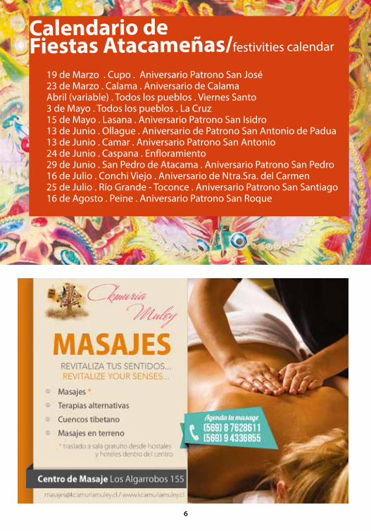
19 de Marzo . Cupo . Aniversario Patrono San José 23 de Marzo . Calama . Aniversario de Calama Abril (variable) . Todos los pueblos . Viernes Santo 3 de Mayo . Todos los pueblos . La Cruz 15 de Mayo . Lasana . Aniversario Patrono San Isidro 13 de Junio . Ollague . Aniversario de Patrono San Antonio de Padua 13 de Junio . Camar . Aniversario Patrono San Antonio 24 de Junio . Caspana . Enfloramiento 29 de Junio . San Pedro de Atacama . Aniversario Patrono San Pedro 16 de Julio . Conchi Viejo . Aniversario de Ntra.Sra. del Carmen 25 de Julio . Río Grande - Toconce . Aniversario Patrono San Santiago 16 de Agosto . Peine . Aniversario Patrono San Roque
Calendario de Fiestas Atacameñas/festivities calendar
6
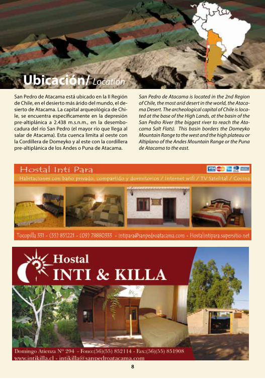
San Pedro de Atacama está ubicado en la II Región de Chile, en el desierto más árido del mundo, el de-sierto de Atacama. La capital arqueológica de Chi-le, se encuentra específicamente en la depresión pre-altiplánica a 2.438 m.s.n.m., en la desembo-cadura del río San Pedro (el mayor río que llega al salar de Atacama). Esta cuenca limita al oeste con la Cordillera de Domeyko y al este con la cordillera pre-altiplánica de los Andes o Puna de Atacama.
San Pedro de Atacama is located in the 2nd Region of Chile, the most arid desert in the world, the Ataca-ma Desert. The archeological capital of Chile is loca-ted at the base of the High Lands, at the basin of the San Pedro River (the biggest river to reach the Ata-cama Salt Flats). This basin borders the Domeyko Mountain Range to the west and the high plateau or Altiplano of the Andes Mountain Range or the Puna de Atacama to the east.
Ubicación/ Location
8

Existen diversas formas para llegar a San Pedro de Atacama:
Líneas aéreas: Al aeropuerto el Loa de Calama llega Lan Chile, Pal airline y Sky Airline; encuentra infor-mación más detallada en la Guía de Servicios.
Transfer desde el aeropuerto: Te llevará en forma directa a San Pedro de Atacama. Para los vuelos de las 7:30 am existen tarifas especiales, reserva con anticipación.
Buses interurbanos: Tur Bus realiza viajes desde Santiago directo a San Pedro de Atacama, o desde cualquier ciudad a Calama. Desde Calama, Tur Bus, Atacama 2000 y Frontera realizan este viaje. Desde Salta-Argentina, Géminis y Pullman Bus son las em-presas que llegan en forma directa a San Pedro. El viaje dura alrededor de nueve horas.
Desde Bolivia no existe transporte comercial direc-to a San Pedro de Atacama, sólo empresas de turis-mo o agencias de viajes.
En vehículo: Sólo hay bombas de bencina en Cala-ma y en San Pedro de Atacama. Si viene desde Ar-gentina los pasos fronterizos están abiertos desde las 8:00 a las 23:00 hrs, dependiendo de las con-diciones climáticas. Infórmate en carabineros por estado de caminos.
There are different ways to get to San Pedro de Atacama:
The airlines that fly to Calama are Lan Chile, Pal airline and Sky Air-line. For further details look at the directory.
If you decide to come by plane, you can take a shuttle from the airport which will take you directly to San Pe-dro de Atacama. For the 7:30am flight there’s a special rate. We recommend you call and make your reserva-tion in advance.
If you come by bus, Tur Bus offers a direct route to San Pedro de Atacama. From Calama you can take a bus from Frontera or Geminis. From Argentina, Geminis and Pullman Bus are the companies that go directly to San Pedro. The trip takes around nine hours. There are no commercial direct transportation services from Bolivia to San Pedro. Tourist companies and agencies are the only ones to offer this service.
If you travel by car, you must keep in mind that the distance between one gas station and another one is considerable since they can only be found in Calama and in San Pedro. If you are coming from Argentina the border passages are open from 8:00 A.M. to 11 P.M, depending on the weather conditions. Find out with the road patrol before departure.
Como llegar/ getting there
San Pedro
SantiagoARGENTINA
CHILE
BOLIVIA
10
11
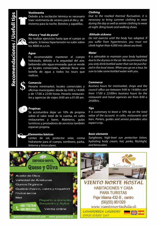
Vestimenta Debido a la oscilación térmica es necesario traer vestimenta de verano para el día y de invierno para la noche. Bototos y zapatillas.
Altura y “mal de puna” No realizar ejercicios hasta que el cuerpo se adapte. Si tienes hipertensión no subir sobre los 4000 m.s.n.m.
Agua Es recomendable mantener el cuerpo hidratado, debido a la sequedad del aire, bebiendo sólo agua envasada, que se vende en locales comerciales, además llevar una botella de agua a todos los tours que realices.
ComercioHorario minimarket, locales comerciales y o�cinas municipales: desde las 9:00 a 14:00h y de 17:00 a 22:00 horas. Horario restauran-tes y agencias de viajes: 8:00 am a 01:00 am.
Propinas Se acostumbra dejar un 10% de propina sobre el valor total de la cuenta, en cafés restaurantes y bares. Maleteros, guías turísticos y prestadores de servicios también esperan propina.
Elementos básicos Lentes de sol, protector solar, crema hidratante para el cuerpo, sombrero, parka, linterna y binoculares.
ClothingDue to the marked thermal �uctuation, it is necessary to bring summer clothing to wear during the day as well as winter clothing to wear at night .Bring boots and walking shoes. Altitude sicknessDo not exercise until the body has adapted. If you su�er from hypertension, you must not climb higher than 4,000 mts above sea level.
WaterIt is advisable to maintain your body hydrated due to the dryness in the air. We recommend that you only drink bottled water that can be purcha-sed in the local stores. When you go on a tour, be sure to take some bottled water with you.
CommerceBusiness hours for minimarket, shops and the council o�ce are between 9:00 to 14:00hrs and from 17:00 a 22:00hrs business hours for the restaurant and travel agencies are from 8:00 a 24:00hrs. .
TipsIt is customary to leave a 10% tip on the total value of the account, in cafes, restaurants and bars. Porters, guides and service providers also expect a tip..
Basic elements Sunglasses, high-level sun protection lotion, hydrating body cream, hat, parka, �ashlight, and binoculars.
Reco
men
daci
ones
/ U
sefu
ll ti
ps

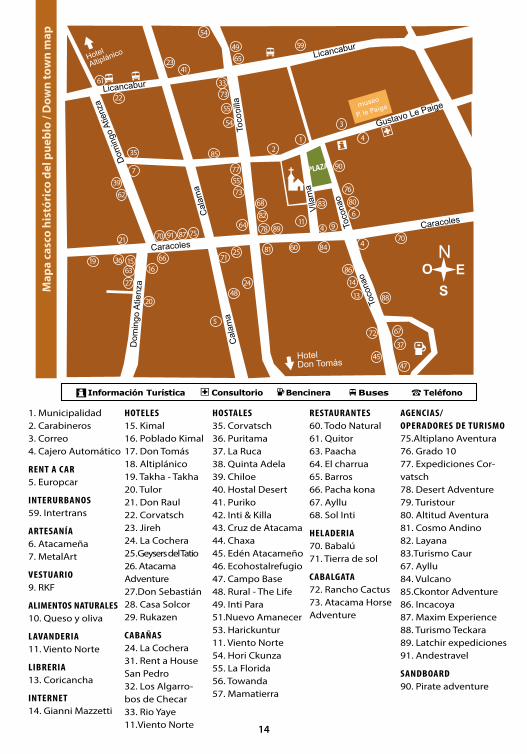
1. Municipalidad2. Carabineros3. Correo4. Cajero Automático
RENT A CAR5. Europcar
INTERURBANOS59. Intertrans
ARTESANÍA6. Atacameña7. MetalArt
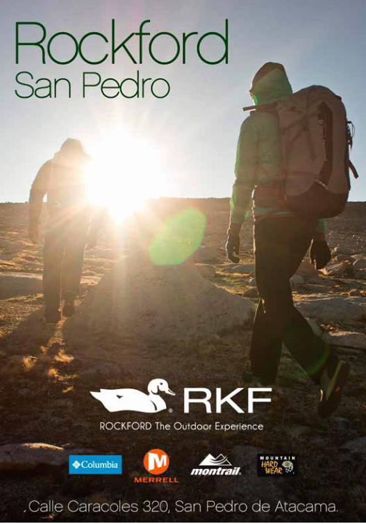
VESTUARIO9. RKF
ALIMENTOS NATURALES10. Queso y oliva
LAVANDERIA11. Viento Norte
LIBRERIA13. Coricancha
INTERNET14. Gianni Mazzetti
HOTELES15. Kimal 16. Poblado Kimal17. Don Tomás18. Altiplánico19. Takha - Takha 20. Tulor21. Don Raul22. Corvatsch23. Jireh24. La Cochera25.Geysers del Tatio26. Atacama Adventure27.Don Sebastián28. Casa Solcor29. Rukazen
CABAÑAS24. La Cochera31. Rent a House San Pedro32. Los Algarro-bos de Checar33. Rio Yaye11.Viento Norte
RESTAURANTES60. Todo Natural61. Quitor63. Paacha64. El charrua 65. Barros66. Pacha kona67. Ayllu68. Sol Inti
HELADERIA70. Babalú71. Tierra de sol
CABALGATA72. Rancho Cactus73. Atacama Horse Adventure
AGENCIAS/OPERADORES DE TURISMO75.Altiplano Aventura76. Grado 1077. Expediciones Cor-vatsch78. Desert Adventure79. Turistour80. Altitud Aventura81. Cosmo Andino82. Layana83.Turismo Caur67. Ayllu84. Vulcano85.Ckontor Adventure86. Incacoya87. Maxim Experience88. Turismo Teckara89. Latchir expediciones91. Andestravel
SANDBOARD90. Pirate adventure
1
HOSTALES35. Corvatsch 36. Puritama37. La Ruca 38. Quinta Adela39. Chiloe40. Hostal Desert41. Puriko42. Inti & Killa43. Cruz de Atacama44. Chaxa45. Edén Atacameño46. Ecohostalrefugio47. Campo Base 48. Rural - The Life49. Inti Para51.Nuevo Amanecer53. Harickuntur11. Viento Norte54. Hori Ckunza55. La Florida56. Towanda57. Mamatierra
2
3
4
4
71
5
911
13
1516
19
20
21
22
23
2427
33
35
36
37
39
4547
48
49
60
62
63
66
68
67
64
65
70 75
76
77
78
81
80
82
86
88
41
90
85
25
Map
a ca
sco
hist
óric
o de
l pue
blo
/ Dow
n to
wn
map
14
72
54
55
54
7
61
87
73
6
470
83
84
8991
59
5573
14
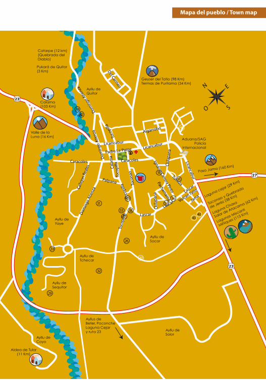
Valle de laLuna (16 Km)
Calama(103 Km)
Ayllu deQuitor
Catarpe (12 km)(Quebrada del Diablo)
Pukará de Quitor(3 Km)
Geyser del Tatio (98 Km)Termas de Puritama (34 Km)
Paso Jama (160 Km)
Ayllu deSocor
Ayllu deSequitor
Ayllu deCoyo
Ayllu deYaye
Ayllu deTchecar
Toconao y Quebrada
de Jeréz (38 Km)
Laguna Chaxa
Salar de Atacama (62 Km)
Lagunas Miscanti
Miñiques (115 Km)
Laguna cejar (29 Km)
Ayllu deSolor
Aldea de Tulor (11 Km)
Aduana/SAGPolicía
internacional
Ayllus deBeter, PoconcheLaguna Cejary ruta 23
LicancaburLicancabur
Licancabur
Dom
ingo
Atie
nza
Palpana
Dom
ingo
Atie
nza
Cala
ma
Toco
pilla
Toco
pilla
Toco
pilla
Padre Le Paige
Toco
nao
Calle
jon
Real
es
Caracoles Caracoles Ignacio Carrera Pinto
Toco
pilla
Lascar
Lascar
Lascar
Tumiza
Volcan Tatio
Jama
Ckila
pana
Ckila
pana
Pachamam
a
Algarrobo
Del Carmen
Domin
go A
tienz
a
Mapa del pueblo / Town map
1842
17
31
29
29
26
10
32
33
3840
43
43
46
53
5657
51
Valle de laLuna (16 Km)
Calama(103 Km)
Ayllu deQuitor
Catarpe (12 km)(Quebrada del Diablo)
Pukará de Quitor(3 Km)
Geyser del Tatio (98 Km)Termas de Puritama (34 Km)
Paso Jama (160 Km)
Ayllu deSocor
Ayllu deSequitor
Ayllu deCoyo
Ayllu deYaye
Ayllu deTchecar
Toconao y Quebrada
de Jeréz (38 Km)
Laguna Chaxa
Salar de Atacama (62 Km)
Lagunas Miscanti
Miñiques (115 Km)
Laguna cejar (29 Km)
Ayllu deSolor
Aldea de Tulor (11 Km)
Aduana/SAGPolicía
internacional
Ayllus deBeter, PoconcheLaguna Cejary ruta 23
LicancaburLicancabur
Licancabur
Dom
ingo
Atie
nza
Palpana
Dom
ingo
Atie
nza
Cala
ma
Toco
pilla
Toco
pilla
Toco
pilla
Padre Le Paige
Toco
nao
Calle
jon
Real
es
Caracoles Caracoles Ignacio Carrera Pinto
Toco
pilla
Lascar
Lascar
Lascar
Tumiza
Volcan Tatio
Jama
Ckila
pana
Ckila
pana
Pachamam
a
Algarrobo
Del Carmen
Domin
go A
tienz
a
18

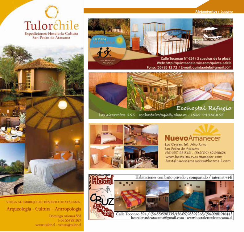
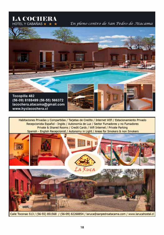
Alojamientos / Lodging
¡Follow us onsocial networks!

21
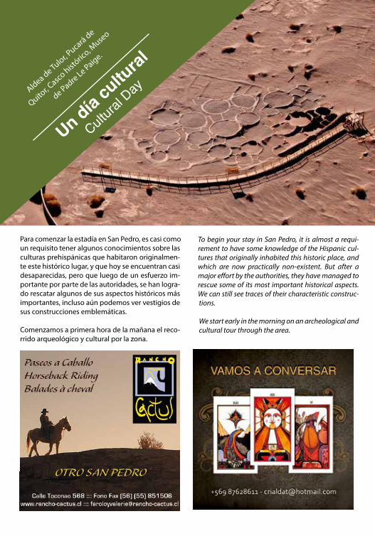
To begin your stay in San Pedro, it is almost a requi-rement to have some knowledge of the Hispanic cul-tures that originally inhabited this historic place, and which are now practically non-existent. But after a major effort by the authorities, they have managed to rescue some of its most important historical aspects. We can still see traces of their characteristic construc-tions.
We start early in the morning on an archeological and cultural tour through the area.
Para comenzar la estadía en San Pedro, es casi como un requisito tener algunos conocimientos sobre las culturas prehispánicas que habitaron originalmen-te este histórico lugar, y que hoy se encuentran casi desaparecidas, pero que luego de un esfuerzo im-portante por parte de las autoridades, se han logra-do rescatar algunos de sus aspectos históricos más importantes, incluso aún podemos ver vestigios de sus construcciones emblemáticas.
Comenzamos a primera hora de la mañana el reco-rrido arqueológico y cultural por la zona.
Aldea de Tulor, Pucará de
Quitor, C
asco históric
o, Muse
o
de Padre Le Paige.
Un día cu
ltural
Cultura
l Day

Aldea de TulorNuestra primera parada es en la Aldea de Tulor. Una especie de villa con más de 3 mil años de antigüe-dad, en donde vivieron las primeras comunidades sedentarias agrupadas en no más de 150 o 200 personas, dedicándose principalmente al tejido, la agricultura, ganadería y cerámica.
Lo que hoy podemos ver en la zona, son los ves-tigios de estas construcciones de adobe, adosadas unas con otras, adquiriendo una forma circular y abovedada que remata con un techo cónico, estas viviendas estaban adosadas unas con otras y se intercomunicaban a través de patios y pasadizos. Hoy se encuentran semi cubiertas por la arena del desierto. Además en el lugar hay una reconstruc-ción idéntica de estas viviendas, la cual es posible visitar.
Our first stop is the village of Tulor. A sort of town that is more than 3,000 years old, where the first sedentary tribes lived, grouped into no more than 150 or 200 people. They were mainly devoted to weaving, agri-culture, livestock and pottery.
What we can see in the area are the remains of these adobe structures attached to one another in a circular form with vaulted coned roofs, which are now half co-vered in sand. oined together by patios and passage-ways that communicated with one another. There is also a reconstruction of these houses that you can visit on the tour.
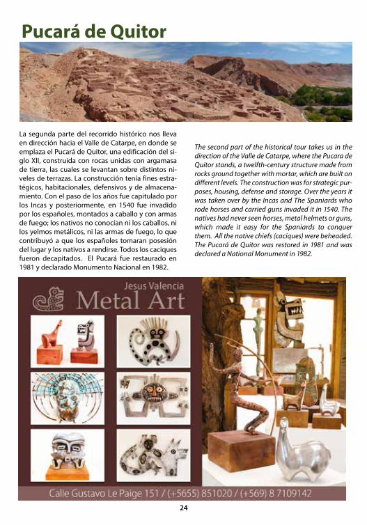
Pucará de Quitor
La segunda parte del recorrido histórico nos lleva en dirección hacia el Valle de Catarpe, en donde se emplaza el Pucará de Quitor, una edificación del si-glo XII, construida con rocas unidas con argamasa de tierra, las cuales se levantan sobre distintos ni-veles de terrazas. La construcción tenía fines estra-tégicos, habitacionales, defensivos y de almacena-miento. Con el paso de los años fue capitulado por los Incas y posteriormente, en 1540 fue invadido por los españoles, montados a caballo y con armas de fuego; los nativos no conocían ni los caballos, ni los yelmos metálicos, ni las armas de fuego, lo que contribuyó a que los españoles tomaran posesión del lugar y los nativos a rendirse. Todos los caciques fueron decapitados. El Pucará fue restaurado en 1981 y declarado Monumento Nacional en 1982.
The second part of the historical tour takes us in the direction of the Valle de Catarpe, where the Pucara de Quitor stands, a twelfth-century structure made from rocks ground together with mortar, which are built on different levels. The construction was for strategic pur-poses, housing, defense and storage. Over the years it was taken over by the Incas and The Spaniards who rode horses and carried guns invaded it in 1540. The natives had never seen horses, metal helmets or guns, which made it easy for the Spaniards to conquer them. All the native chiefs (caciques) were beheaded. The Pucará de Quitor was restored in 1981 and was declared a National Monument in 1982.
24

Casco histórico. Down town
Este hermoso poblado debe su nombre al Santo Patrono San Pedro, y la palabra Atacama, según cuentan sus ancestros, proviene del idioma Cunza ¨Accatchca¨ que significa Cabecera del país, esta palabra con el tiempo fue sufriendo modificacio-nes hasta llegar a la pronunciación de hoy. San Pe-dro de Atacama fue conquistada por los incas en 1450 y luego por los españoles en 1540, constitu-yéndose el cabildo en 1555.
La plaza es sin duda uno de los atractivos de La Capital arqueológica de Chile, nada mejor que ver el tiempo pasar bajo sus enormes pimientos o molles, árboles que te refrescarán en las tardes de verano.
A un costado de la plaza encontramos la Iglesia de San Pedro de Atacama, sin duda una de las más hermosas del norte de Chile, no se conoce su fecha de construcción, sin embargo ya funcionaba como parroquia en 1641; en 1951 fue declarada Monu-mento Nacional. Para su construcción se utilizó adobe en sus paredes y madera de Chañar y alga-rrobo, paja y barro en sus techos, los cuales fueron revestidos con madera de cactus.
This beautiful town is named after its patron saint San Pedro (Saint Peter), and the word Atacama, which, ac-cording to the ancestors comes from “Accatchca” in the Cunza language and means Head of the Country. Over time, this term underwent many modifications until it arrived at today’s pronunciation. It was con-quered by the Incas in 1450 and then by the Spaniards in 1540 becoming a cabildo (a Chilean government seat) in 1555.
The town square is without a doubt one of the main attractions of Chile’s archeological capital. There is nothing better than to watch time go by under its enormous pepper or molle trees which will cool you off in the summer evenings. On one side of the square you will find the San Pedro de Atacama Church; undoubtedly one of the most beautiful churches of the north of Chile. Its construc-tion date is unknown, however, it served as a parish in 1641 and in 1951 it was declared a National Monu-ment. The walls are made of adobe and the ceilings are made of Chañar tree (Geoffroea decorticans), locust tree, and clay, which were later covered with cactus wood.
26

Frente a la plaza encontraremos la Municipalidad de San Pedro de Atacama, carabineros, el correo, el Museo de Padre le Paige (descrito en la sección Tour arqueológico) y SERNATUR. El casco histórico todavía conserva la estructura y construcción de la influencia de la colonia española, antiguas casas pa-readas con patios interiores, construidas en adobe con techos de paja y barro. Sus calles de tierra han sido tratadas con vichufita, un producto derivado del salar que permite conservar la estética original, ocasionando menor polución. Su calle principal “Caracoles” debe su nombre a que antiguamente desde este punto partían grupos de mineros a tra-bajar en la Mina de Plata Caracoles, descubierta en 1870 por Diaz Gana. Hoy en día, esta calle peatonal está provista de restaurantes, agencias de turismo y almacenes que dan la bienvenida a turistas de todo el mundo.
Downtown San Pedro still preserves the structure and construction of the Spanish colonial influence, antique adobe houses with interior yards, and roofs made of clay and hay.
Today’s dirt streets have been treated with vichufita, a product derived from salt, which allows them to re-tain the original look causing less pollution.
The main street is Caracoles, so named because in earlier days miners left from here to work in the Ca-racoles silver mine discovered in 1870 by Diaz Gana. Now a days you can find nice restaurants, tourist agencies and stores, which welcome tourists from all over the world.
27
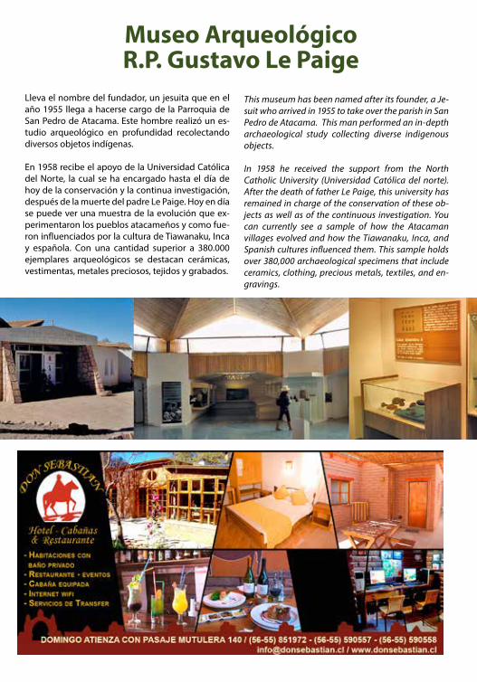
Museo ArqueológicoR.P. Gustavo Le Paige
Lleva el nombre del fundador, un jesuita que en el año 1955 llega a hacerse cargo de la Parroquia de San Pedro de Atacama. Este hombre realizó un es-tudio arqueológico en profundidad recolectando diversos objetos indígenas.
En 1958 recibe el apoyo de la Universidad Católica del Norte, la cual se ha encargado hasta el día de hoy de la conservación y la continua investigación, después de la muerte del padre Le Paige. Hoy en día se puede ver una muestra de la evolución que ex-perimentaron los pueblos atacameños y como fue-ron influenciados por la cultura de Tiawanaku, Inca y española. Con una cantidad superior a 380.000 ejemplares arqueológicos se destacan cerámicas, vestimentas, metales preciosos, tejidos y grabados.
This museum has been named after its founder, a Je-suit who arrived in 1955 to take over the parish in San Pedro de Atacama. This man performed an in-depth archaeological study collecting diverse indigenous objects.
In 1958 he received the support from the North Catholic University (Universidad Católica del norte). After the death of father Le Paige, this university has remained in charge of the conservation of these ob-jects as well as of the continuous investigation. You can currently see a sample of how the Atacaman villages evolved and how the Tiawanaku, Inca, and Spanish cultures influenced them. This sample holds over 380,000 archaeological specimens that include ceramics, clothing, precious metals, textiles, and en-gravings.
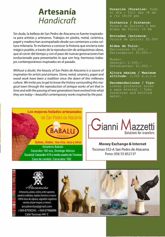
ArtesaníaHandicraft
Sin duda, la belleza de San Pedro de Atacama es fuente inspirado-ra para artistas y artesanos. Trabajos en piedra, metal, cerámica, papel y madera han acompañado desde sus comienzos a esta cul-tura milenaria. Te invitamos a conocer la historia que encierra este mágico pueblo, a través de la reproducción de antiquísimas obras, que al correr del tiempo y con el paso de nuevas generaciones han evolucionado para presentarles lo que son hoy, hermosos traba-jos contemporáneos inspirados en el pasado.
Without a doubt, the beauty of San Pedro de Atacama is a source of inspiration for artists and artisans. Stone, metal, ceramics, paper and wood work have been a tradition since the dawn of this millenary culture. We invite you to get to know the history surrounding this ma-gical town through the reproduction of antique works of art that in time and with the passing of new generations have evolved into what they are today—beautiful contemporary works inspired by the past.
Duración /Duration: Todo el día / full day (8 am a /to 18:00 pm)
Distancia / Distance: Pucará de Quitor: 3 kms Aldea de Tulor: 10 Km
Entradas /entrance:Pucará de Quitor: $2.000
Aldea de Tulor:Necionales $3.000.-Extrangeros: $5.000.-
Museo: General: 2.500.-Estudiantes: $1.000.-
Altura máxima / Maximum altitude: 2,500 m.s.n.m
Recomendaciones / Tips: Llevar protector solar y agua mineral / Take sunscreen and bottled water.
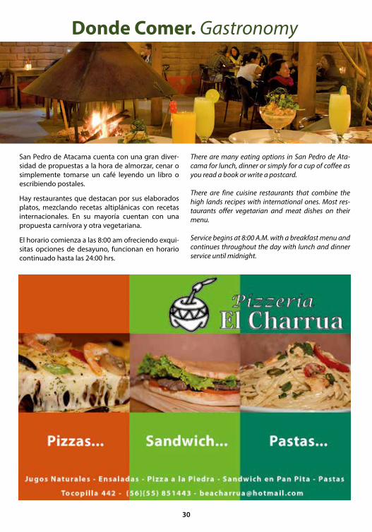
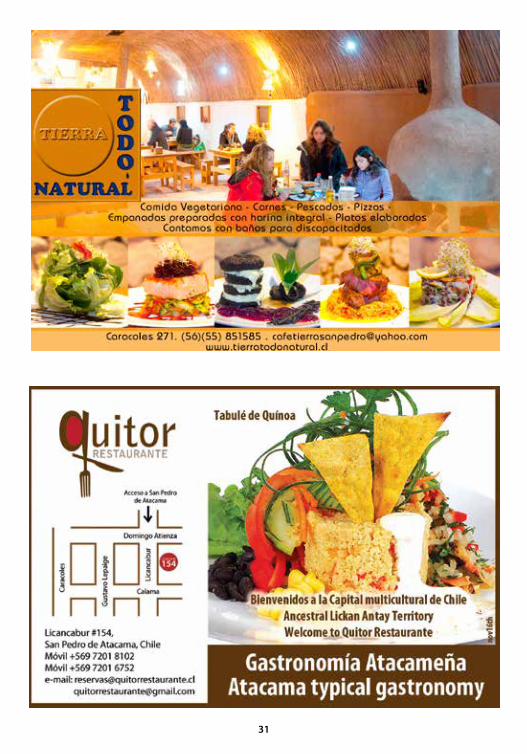
Donde Comer. Gastronomy
San Pedro de Atacama cuenta con una gran diver-sidad de propuestas a la hora de almorzar, cenar o simplemente tomarse un café leyendo un libro o escribiendo postales.
Hay restaurantes que destacan por sus elaborados platos, mezclando recetas altiplánicas con recetas internacionales. En su mayoría cuentan con una propuesta carnívora y otra vegetariana.
El horario comienza a las 8:00 am ofreciendo exqui-sitas opciones de desayuno, funcionan en horario continuado hasta las 24:00 hrs.
There are many eating options in San Pedro de Ata-cama for lunch, dinner or simply for a cup of coffee as you read a book or write a postcard.
There are fine cuisine restaurants that combine the high lands recipes with international ones. Most res-taurants offer vegetarian and meat dishes on their menu.
Service begins at 8:00 A.M. with a breakfast menu and continues throughout the day with lunch and dinner service until midnight.
30
31

Visitaremos el v
alle de la
muerte
,
valle de la
luna, cuevas de sal, t
res
marías y la
gran duna
Un día inten
so / I
ntensiv
e day
Sandb
oard
& trekki
ng
cordill
era de
la sal
Una alternativa para los que disfrutan de
los deportes extremos, es hacer el tour que incluye San-
dboard en el Valle de la Muerte, con una experiencia más dinámica,
que solo recorrer estos hermosos para-jes en vehículo. Además incluye la tabla e
instructor, junto con la visita a los atractivos naturales que se visitan en el tour regular.
Descender por las dunas de más 120 mts, en el Valle de la Muerte, en una tabla similar a un snow-board es una experiencia única, con una mezcla perfecta de placer y adrenalina.
Este es un deporte apto para cualquiera, fácil de aprender, en el cual tendrás toda la libertad para surfear las dunas según tu propia habilidad. Exis-ten distintos tipos de tablas, las mejores son aque-llas en las que puedes deslizarte por la arena, hacer saltos y piruetas dignas de los x-games.
SandboardValle de la Muerte
An alternative for those who enjoy extreme sports, is to do the tour that includes sandboarding in Death Valley, with a more dynamic experience, than only visiting these beautiful places by vehicle. It also in-cludes the board and instructor, together with the visit to the natural attractions that are visited in the regular tour.
To descend the more than 120-meter long dunes of Death Valley on a sand board (similar to a snow-board) is a truly unique experience with a perfect mix of pleasure and adrenaline. This is a suitable sport for anyone, easily to learn, in which you will have all the freedom to surf the dunes according to your own skill. Different types of boards exist, the best are those that allow you to slide on the sand, do jumps and spins and flips worthy of the X-Games
32
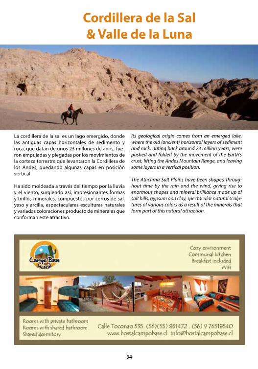
A eso de las 15 horas, las calles del pueblo se llenan de turistas que esperan afuera de cada agencia el bus que los llevará a uno de los destinos imperdi-bles de Atacama, el Valle de Luna, ubicado a solo 4 kilómetros de San Pedro, y que es sin duda uno de los paisajes desérticos más atractivos y más recono-cidos del mundo. Todos vienen a fotografiarse en la roca del coyote. La primera parada es en el mirador del Valle de La Muerte, en donde luego de una pe-queña caminata se llega a un mirador con una vista panorámica que permite observar casi todo el ca-ñón. El paisaje que pareciera no tener fin, sorpren-de con las diversas formaciones arenosas y rocosas que adquieren diversas siluetas. En el horizonte se funde la cordillera de los Andes y sus cumbres neva-das con el azul del cielo atacameño. Luego de unos pocos minutos de recorrido, aparece otro mirador con vista a la cordillera de la sal. Justo sobre el ba-rranco, sobresale de éste, la famosa roca del coyote. Todos sin excepción, posan para inmortalizar el mo-mento en una fotografía.
Miradores Valle de la MuerteAt about 3pm, the town’s streets fill with tourists out-side each agency waiting for their bus to take them to one of the must-see destinations of Atacama, the Valle de la Luna (Valley of the Moon), located just 4 kilome-ters from San Pedro, and it is without a doubt one of the most attractive and recognized desert landscapes in the world. Many come to be photographed at Co-yote Rock. The first stop is the viewpoint of Death Va-lley, where after a short walk leads to a lookout with a panoramic view that allows us to observe most of the canyon. The landscape seems to be endless surprising us with various sandy and rocky formations that take on different shapes. On the horizon the blue Atacama sky melts into the Andes Mountains and its snowy peaks. After a few minutes’ drive, a separate viewpoint overlooking the salt mountain range. Just above the ravine, stands before it, the famous Coyote Rock. Ever-yone poses to capture the moment in a photograph.
Cordillera de la Sal & Valle de la Luna
La cordillera de la sal es un lago emergido, donde las antiguas capas horizontales de sedimento y roca, que datan de unos 23 millones de años, fue-ron empujadas y plegadas por los movimientos de la corteza terrestre que levantaron la Cordillera de los Andes, quedando algunas capas en posición vertical.
Ha sido moldeada a través del tiempo por la lluvia y el viento, surgiendo así, impresionantes formas y brillos minerales, compuestos por cerros de sal, yeso y arcilla, espectaculares esculturas naturales y variadas coloraciones producto de minerales que conforman este atractivo.
Its geological origin comes from an emerged lake, where the old (ancient) horizontal layers of sediment and rock, dating back around 23 million years, were pushed and folded by the movement of the Earth’s crust, lifting the Andes Mountain Range, and leaving some layers in a vertical position.
The Atacama Salt Plains have been shaped throug-hout time by the rain and the wind, giving rise to enormous shapes and mineral brilliance made up of salt hills, gypsum and clay, spectacular natural sculp-tures of various colors as a result of the minerals that form part of this natural attraction.
34

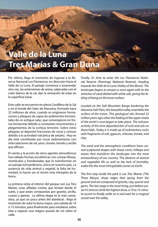
Por último, llega el momento de ingresar a la Re-serva Nacional Los Flamencos, en dirección hacia el Valle de La Luna. El paisaje comienza a sorprender otra vez, las extensiones de arena, salpicadas con el color blanco de la sal, dan la sensación de estar en la superficie lunar.
Este valle se encuentra en plena Cordillera de la Sal y en el borde del Salar de Atacama, formado hace 22 millones de años, cuando se originaron forma-ciones y pliegues de capas de sedimentos horizon-tales de un antiguo salar, que convergieron en for-ma horizontal debido a constantes movimientos y plegamientos de la corteza terrestre. Sobre estos pliegues se depositó fracciones de rocas y cenizas debido a la actividad volcánica de antaño. Hoy en día está constituido por rocas sedimentarias con intercalaciones de sal, yeso, clorato, borato y arcilla que afloran.
El viento y la acción de otros agentes atmosféricos han tallado formas escultóricas con crestas filosas, montículos y hondonadas que lo transforman en un paisaje extraordinario, único en nuestro país. La ausencia de vida animal y vegetal, la falta de hu-medad, lo hacen ser el rincón más inhóspito de la tierra.
La primera visita al interior del parque son Las Tres Marías, unas afiladas crestas que brotan desde el suelo, y que están compuestas por granito, arcilla, cuarzo y gemas. La última etapa es la más cansa-dora, ya que un poco antes del atardecer, llega el momento de subir la duna mayor, una subida de 10 o 15 minutos, para finalmente para instalarse sobre ésta a esperar una mágica puesta de sol sobre el valle.
Valle de la LunaTres Marías & Gran Duna
Finally, it’s time to enter the Los Flamencos Natio-nal Reserve (Flamingo National Reserve), heading towards the Valle de la Luna (Valley of the Moon). The landscape begins to amaze us once again with its the stretches of sand dotted with white salt, giving the fe-eling of being on the lunar surface.
Located on the Salt Mountain Range bordering the Atacama Salt Flats; this beautiful valley resembles the surface of the moon. This geological site ,formed 22 million years ago when the folding of the upper strata of the earth’s crust began to take place. The volcanic activity of the time deposited bits of rock and ash on these folds. Today it is made up of sedimentary rocks with fragments of salt, gypsum, chlorate, borate, and clay.
The wind and the atmospheric conditions have car-ved sculptured shapes with sharp crests, hilltops and waves that transform the landscape into the most extraordinary of our country. The absence of animal and vegetable life as well as the lack of humidity, make this the most inhospitable corner on Earth.
The first stop inside the park is Las Tres Marias (The Three Marys), sharp ridges that spring from the ground and are composed of granite, clay, quartz and gems. The last stage is the most tiring, just before sun-set it’s time to climb the highest dune, a 10 to 15-minu-te ascent to finally settle on it and wait for a magical sunset over the valley.
38
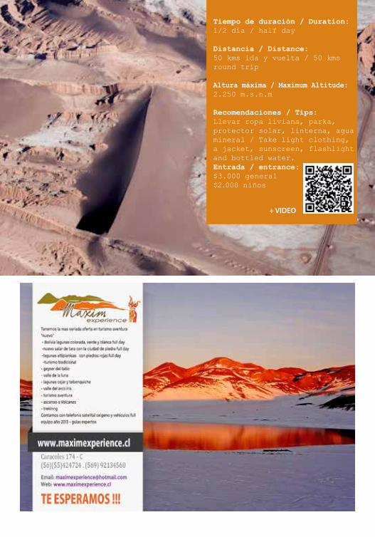
Tiempo de duración / Duration: 1/2 día / half day
Distancia / Distance: 50 kms ida y vuelta / 50 kms round trip
Altura máxima / Maximum Altitude: 2.250 m.s.n.m
Recomendaciones / Tips: Llevar ropa liviana, parka, protector solar, linterna, agua mineral / Take light clothing, a jacket, sunscreen, flashlight and bottled water.Entrada / entrance:$3.000 general$2.000 niños
+ VIDEO
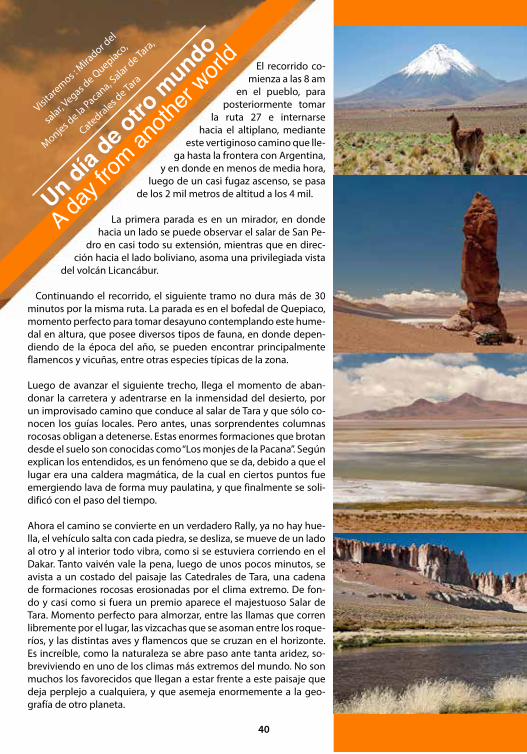
El recorrido co-mienza a las 8 am
en el pueblo, para posteriormente tomar
la ruta 27 e internarse hacia el altiplano, mediante
este vertiginoso camino que lle-ga hasta la frontera con Argentina,
y en donde en menos de media hora, luego de un casi fugaz ascenso, se pasa
de los 2 mil metros de altitud a los 4 mil.
La primera parada es en un mirador, en donde hacia un lado se puede observar el salar de San Pe-
dro en casi todo su extensión, mientras que en direc-ción hacia el lado boliviano, asoma una privilegiada vista
del volcán Licancábur.
Continuando el recorrido, el siguiente tramo no dura más de 30 minutos por la misma ruta. La parada es en el bofedal de Quepiaco, momento perfecto para tomar desayuno contemplando este hume-dal en altura, que posee diversos tipos de fauna, en donde depen-diendo de la época del año, se pueden encontrar principalmente flamencos y vicuñas, entre otras especies típicas de la zona.
Luego de avanzar el siguiente trecho, llega el momento de aban-donar la carretera y adentrarse en la inmensidad del desierto, por un improvisado camino que conduce al salar de Tara y que sólo co-nocen los guías locales. Pero antes, unas sorprendentes columnas rocosas obligan a detenerse. Estas enormes formaciones que brotan desde el suelo son conocidas como “Los monjes de la Pacana”. Según explican los entendidos, es un fenómeno que se da, debido a que el lugar era una caldera magmática, de la cual en ciertos puntos fue emergiendo lava de forma muy paulatina, y que finalmente se soli-dificó con el paso del tiempo.
Ahora el camino se convierte en un verdadero Rally, ya no hay hue-lla, el vehículo salta con cada piedra, se desliza, se mueve de un lado al otro y al interior todo vibra, como si se estuviera corriendo en el Dakar. Tanto vaivén vale la pena, luego de unos pocos minutos, se avista a un costado del paisaje las Catedrales de Tara, una cadena de formaciones rocosas erosionadas por el clima extremo. De fon-do y casi como si fuera un premio aparece el majestuoso Salar de Tara. Momento perfecto para almorzar, entre las llamas que corren libremente por el lugar, las vizcachas que se asoman entre los roque-ríos, y las distintas aves y flamencos que se cruzan en el horizonte. Es increíble, como la naturaleza se abre paso ante tanta aridez, so-breviviendo en uno de los climas más extremos del mundo. No son muchos los favorecidos que llegan a estar frente a este paisaje que deja perplejo a cualquiera, y que asemeja enormemente a la geo-grafía de otro planeta.
Visitaremos :
Mirador d
el
salar, V
egas de Q
uepiaco,
Monjes de la
Pacana, Salar d
e Tara,
Catedrales de Ta
ra
Un día de o
tro m
undo
A day f
rom an
other
world
40

The tour begins at 8 am in town, to then head out on Route 27 and penetrate the highlands through this dizzying path which leads to the border with Argentina, where in half an hour, after a brief ascent, we pass over the 2,000 meter mark to 4,000 meters.
The first stop is at a viewpoint where on one side you can see the salt flats of San Pedro to its full extent, meanwhile hea-ding to the Bolivian side to overlook a superb view of the vol-cano Licancabur.
Moving on, the next leg of the tour takes less than 30 minutes on the same route. The stop is at the wetlands of Quepiaco; the perfect time to have breakfast as we observe this elevated wetland. Here we can find various types of wildlife, where de-pending on the time of year is mainly flamingos and vicuñas, among other species of the zone.
After advancing a bit more, it’s time to leave the road and enter into the vastness of the desert on an improvised road to the Salar de Tara (Tara Salt Flats) and known only to the local guides. But first, amazing rock columns compel us to stop. These huge formations that sprout from the ground are known as “los monjes de la Pacana.” According to the experts, it is a phenomenon that occurs because of the magma spring that once was here, where at certain points lava emerged very gradually, and eventually solidified over time.
Now the road becomes a real rally, there is no trail, the car jumps with every rock, slides, moves from side to side and everything inside vibrates as if we were racing in the Dakar. After a few minutes, you can see the side of the Catedrales de Tara (Tara Cathedrals), a chain of rock formations eroded by extreme weather. In the background the majestic Salar de Tara (Tara Salt Flats) appears; the perfect time for lunch amid the llamas that wonder freely, vizcachas that gaze between the rocks, and various birds and flamingos that cross the ho-rizon. It’s amazing how nature gives way to so much aridity, yet survives in one of the world’s most extreme climates. The-re are not many who get a chance to contemplate this lands-cape that greatly resembles the geography of another planet.
Duración /Duration: Todo el día / full day (8 am a /to 18:00 pm)
Distancia / Distance: 270 kms ida y vuelta / 270 kms round trip
Altura máxima / Maximum altitude: 4,900 m.s.n.m
Recomendaciones / Tips: Llevar parka, protec-tor solar y agua mine-ral / Take a jacket, sunscreen and bottled water.
+ Video
41

Termas de Puritama
Camino a las Termas
de Puritama se encuentra la que-
brada de Guatin, un cañón rocoso donde atra-
viesa un río de aguas tibias (debido a la unión del río Puritama
de agua termal y el Purifica de aguas heladas) ideal para refrescarse en días de
verano. En este sector podrás observar flo-ra típica de la zona (cojín de la suegra, rica-rica,
cola de zorro, entre otros) y un asombroso bosque de cardones o cactus milenarios de impresionante altura. Tomando un desvío a la derecha del camino hacia Machuca y continuando por una cuesta, se encuentra este río de agua termal, con fluidos cons-tantes entre 25ºC y 30ºC. Los Baños de Puritama, ubicados a 30 Km. de San Pedro de Atacama, son aguas termales que bañan un profundo cajón roco-so, formando pozones escalonados, unos tras otros. De sus aguas cálidas se desprenden diversos mine-rales que poseen cualidades para la cura de enfer-medades reumáticas y para el baño terapéutico.
On the way to the Puritama Hot Springs you will see the Guatin Canyon, a rocky canyon were a lukewarm stream flows (because of the confluence of the Purita-ma River’s thermal water and the Purifica River’s cold water).
It is perfect for a refreshing bath in the summer sea-son. In this area you will observe the local flora (cojin de la vieja, rica-rica, cola de zorro, among others) and an amazing ancient forest of Cactus (Cardones) at an incredible altitude. Taking a right detour from the road to Machuca and continuing uphill you will find the Pu-ritama Hot Springs.
Located 30 kilometers from San Pedro de Atacama in a rocky canyon where these hot springs form pools, one after another like terraces. These hot spring wa-ters contain minerals that help cure rheumatic illness-es and are good for therapeutic baths. There is an infrastructure that meets the tourist’s needs.
Visitaremos Q
uebra-
da de Guatin y Term
as de
Puritama
Día de r
elax y
contem
plación
a day
of rel
ax an
d con
templa
tion
42

* Se prohibe el ingreso con mascotas.
43
Continuando por este camino se encuentran los ojos de Tebinquiche, pequeños pozones de agua dulce con un profundo fondo, luego se accede a la laguna Tebinquiche, la cual tiene características similares a la laguna Chaxa, sus aguas dependen de los deshielos y de las lluvias del año. La mayoría de las agencias de turismo, preparan un picnic justo al momento del atardecer. Papas fritas, galletas, jugo y el infaltable Pisco Sour, amenizan la tarde.
En el horizonte el sol comienza a ponerse tras las montañas, y los últimos rayos de éste, generan una gama de colores azules y violetas, además de convertir la laguna en un verdadero espejo, en donde se refleja el paisaje con sus volcanes y cumbres nevadas. Casi todos aprovechan la ocasión, para inmortalizar el recuerdo en sus fotografías.
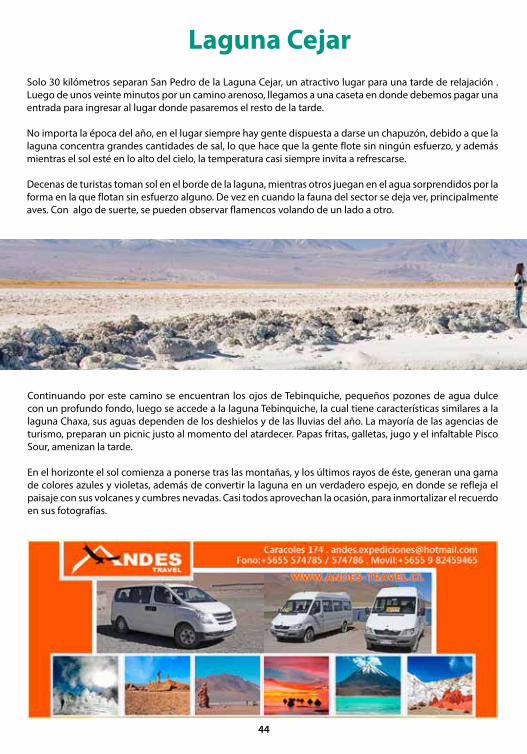
Laguna CejarSolo 30 kilómetros separan San Pedro de la Laguna Cejar, un atractivo lugar para una tarde de relajación . Luego de unos veinte minutos por un camino arenoso, llegamos a una caseta en donde debemos pagar una entrada para ingresar al lugar donde pasaremos el resto de la tarde.
No importa la época del año, en el lugar siempre hay gente dispuesta a darse un chapuzón, debido a que la laguna concentra grandes cantidades de sal, lo que hace que la gente flote sin ningún esfuerzo, y además mientras el sol esté en lo alto del cielo, la temperatura casi siempre invita a refrescarse.
Decenas de turistas toman sol en el borde de la laguna, mientras otros juegan en el agua sorprendidos por la forma en la que flotan sin esfuerzo alguno. De vez en cuando la fauna del sector se deja ver, principalmente aves. Con algo de suerte, se pueden observar flamencos volando de un lado a otro.
44

Only 30 kilometers separate San Pedro from the Laguna Cejar, an attractive place for an afternoon of relaxation. After about twenty minutes on a sandy road, we reach a house where we buy a ticket to enter and spend the rest of the afternoon. No matter what the time of year is, there are always people willing to take a dip because the lagoon contains large amounts of salt that makes people float effortlessly, and as long as the sun is high in the sky, the temperature is almost always inviting and refreshing. Dozens of tourists sunbathe on the edge of the lagoon, while others play in the water surprised by the way they float with ease. Occasionally the fauna of the area can be seen, mainly birds. With any luck, you can see flamingos flying from one side to another.
Following this road you will find the Tebinquiche Springs, small freshwater springs with a very deep bottom. Then you arrive to the Tebinquiche Lagoon, which has similar characteristics to the Chaxa Lagoon; its water depends on the thaw and seasonal rainfall. Most travel agencies prepare a picnic right at sunset; potato chips, cookies, juice and the must-have Pisco Sour to brighten up the evening.
On the horizon the sun begins to set behind the mountains, and the last rays generate a palette of blues and violets, as well as convert the lake into a real mirror, which reflects the landscape of the snow-capped volcanoes. Almost all take the opportunity to immortalize the memory with their cameras.
Tiempo de duración / Duration: 1/2 día / Half Day
Distancia / distance: 60 km ida y vuelta / 60 kms round trip
Altura máxima / Maximum altitude: 2.450 m.s.n.m.
Recomendaciones / Tips: Llevar traje de baño, toalla, bidón de agua, bloqueador solar / Take a swimsuit, a towel, 5 lts. of water to wash the salt from your body.
Valor entrada / Entrance fee : $2.000.-
+ VIDEO
45
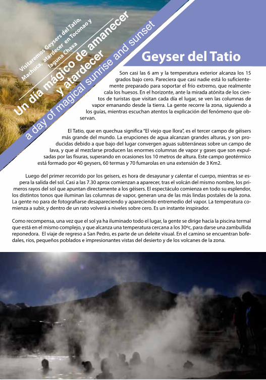
Geyser del TatioSon casi las 6 am y la temperatura exterior alcanza los 15
grados bajo cero. Pareciera que casi nadie está lo suficiente-mente preparado para soportar el frío extremo, que realmente
cala los huesos. En el horizonte, ante la mirada atónita de los cien-tos de turistas que visitan cada día el lugar, se ven las columnas de
vapor emanando desde la tierra. La gente recorre la zona, siguiendo a los guías, mientras escuchan atentos la explicación del fenómeno que ob-
servan.
El Tatio, que en quechua significa “El viejo que llora”, es el tercer campo de géisers más grande del mundo. La erupciones de agua alcanzan grandes alturas, y son pro-
ducidas debido a que bajo del lugar convergen aguas subterráneas sobre un campo de lava, y que al mezclarse producen las enormes columnas de vapor y gases que son expul-
sadas por las fisuras, superando en ocasiones los 10 metros de altura. Este campo geotérmico está formado por 40 geysers, 60 termas y 70 fumarolas en una extensión de 3 Km2.
Luego del primer recorrido por los geisers, es hora de desayunar y calentar el cuerpo, mientras se es-pera la salida del sol. Casi a las 7.30 aprox comienzan a aparecer, tras el volcán del mismo nombre, los pri-
meros rayos del sol que apuntan directamente a los géisers. El espectáculo comienza en todo su esplendor, los distintos tonos que iluminan las columnas de vapor, generan una de las más lindas postales de la zona. La gente no para de fotografiarse desapareciendo y apareciendo entremedio del vapor. La temperatura co-mienza a subir, y dentro de un rato volverá a niveles sobre cero. Es un instante inspirador.
Como recompensa, una vez que el sol ya ha iluminado todo el lugar, la gente se dirige hacia la piscina termal que está en el mismo complejo, y que alcanza una temperatura cercana a los 30ºc, para darse una zambullida reponedora. El viaje de regreso a San Pedro, es parte de un deleite visual. En el camino se encuentran bofe-dales, ríos, pequeños poblados e impresionantes vistas del desierto y de los volcanes de la zona.
Visitaremos Geysers del Tatio
,
Machuca, atard
ecer en Toconao y
laguna Chaxa
Un día mág
ico de a
manec
er
y atar
decer
a day
of mag
ical su
nrise
and s
unset
It’s almost 6 am and the outside temperature reaches -15º C. It seems that almost nobody is prepared to withs-tand such extreme cold that chills you to the bone. On the horizon, to the astonishment of the hundreds of tou-rists visiting this place every day, you can see the steam plumes emanating from the earth. People stroll the area, following the guides while listening attentively to the explanation of the phenomenon they observe before them.
El Tatio (the Geysers), which in Quechua means “old man crying,” is the third largest geyser field in the world. The eruptions of water reach great heights, and are produced due to the convergence of groundwater above a lava field which when mixed, produces huge plumes of steam and gases are expelled through the cracks sometimes exceeding 10 meters.
After the first tour of the geysers, it’s time for breakfast and something to warm up the body as we wait for the sunrise. At about 7:30 am the first rays of sunlight begin to appear behind the volcano El Tatio. This in when the show truly starts in its entire splendor. The different shades illuminate the columns of steam, generating one of the most beautiful sights in the area. People snap photos coming and going amid the steam. The temperature starts to rise and it won’t be long until the levels are back above zero. It is an inspiring moment. Most comment how comfortable the temperature is now, after having endured the extremes conditions.
As a reward, once the sun has lit up the area, people go to the hot springs for a rejuvenating dip located on the same grounds. It reaches a temperature of around 30º C.
The trip back to San Pedro is also part of the visual delight. As we head back, we come across wetlands, rivers, small villages and breathtaking views of the desert and volcanoes in the area.
Tiempo de duración / Duration: 8 hrs aprox. (4:00 am a/to 13:00 pm)
Distancia / Distance: 200 km ida y vuelta / 200 Kms go and return
Altura máxima / Maximum atlitude: 4,320 m.s.n.m
Recomendaciones / Tips: Llevar parka, pro-tector solar, traje de baño, toalla, agua mineral / Take a parka or coat, sunscreen, a swimsuit, a towel and bottled water.
Valor entrada / Entrance fee : $3.500.- Chilenos / $ 5.000.- foreign
+ Video

Laguna ChaxaA eso de las 15 horas, Nos dirigimos hacia la laguna Chaxa, ubicada a 60 kilómetros de San Pedro, en pleno Salar de Atacama. Pero antes, la primera para-da será en una pequeña localidad llamada Toconao.
El vehículo se detiene al costado de la autopista y nos deja en el desierto. Caminamos no más de unos 5 minutos y de pronto nos encontramos frente a la milenaria quebrada de Jeré. Un cañón lleno de ro-cas y vegetación. El chañar, árbol típico de la zona, abunda en ésta.
Por un sendero que a medida que avanzamos se convierte en una especie de túnel, rodeamos la quebrada y luego de unos 15 minutos de caminata, aparecemos en el corazón de Toconao.
Recorremos la iglesia y la plaza principal, ambas edificaciones de la época colonial. Volvemos al ve-hículo y continúanos el camino por la autopista. Luego de un rato, el conductor sale de la ruta prin-cipal, tomando una desviación para internarse en el desierto.
At about 3pm, We head to the Laguna Chaxa, located 60 kilometers from San Pedro, in the Salar de Ataca-ma (Atacama Salt Flat). The first stop will be in a small town called Toconao.
The vehicle stops alongside the highway, and leaves us in the desert. We walk no more than 5 minutes and suddenly we encounter the ancient ravine Jeré; a can-yon full of rocks and vegetation. The Chañar, a typical tree of the area, is abundant here. As we move down the path, it becomes a kind of tunnel.
We go around the valley and after about a 15-minute walk, we arrive in the heart of Toconao.
There, we tour a colonial era church and main squa-re. We return to the vehicle and continue down the highway. After a while, the driver leaves the main road, taking a diversion to go into the desert.
48
Un letrero da la bienvenida a la Reserva Nacional Los Flamencos. El terreno comienza adquirir un co-lor cada vez más blanco y ya se notan los agrietados bloques de sal, entre ellos asoman los cachiyuyos, la única vegetación que crece en el lugar. No hay duda, estamos en el Salar de Atacama, el más gran-de de Chile. Llega la hora de continuar el recorrido a pie, avanzado sobre senderos que han sido cons-truidos en el salar. Un ligero olor a azufre comienza a intensificarse, pero pasa a segundo plano en cuanto distinguimos los diferentes tipos de flamencos que habitan sobre la laguna Chaxa; chileno, andino y de james son los ejemplares de la zona.
En el horizonte, el sol desciende tras la cordillera de Domeyko reflejándose en toda la extensión del salar. La gama de colores que se aprecian sobre el agua, repleta además, de otras aves como el chorlo de la puna, la gaviota andina, y el playero de baird entre otros, transforma el horizonte en un espectá-culo de la naturaleza. Mágicos tonos azules, violetas y naranjos que se mezclan con éstas, crean una pos-tal imborrable, y que de seguro encanta a cualquier amante de la naturaleza.
A sign welcomes us to Los Flamencos National Reserve (Flamingo National Reserve). As we enter, the ground begins to change to a whiter color and you can notice the cracked blocks of salt where you can see the Ca-chiyuyos emerging; the only vegetation that grows in this place. No doubt, we are in the Salar de Atacama, the largest in Chile.
Here we continue the journey on foot, advancing on trails that have been built in the salt flat. A slight smell of sulfur starts to arise, but takes a back seat as we ob-serve the different types of flamingos that inhabit the Laguna Chaxa; the Chilean, Andean and James are the species of the area.
On the horizon, the sun descends behind the Cordille-ra Domeyko (mountain range), reflecting the full ex-tent of the salt flat. You can admire a beautiful range of colors that can be seen on the water and other birds such as the Puna Plover, Andean Seagull, and Baird’s Sandpiper among others, which transforms the hori-zon into a marvel of nature. Magical blue, violet and orange tones merge creating an unforgettable post-card that will surely be adored by any nature lover.
Duración /Duration: Medio el día / Half day
Distancia / Distance: 60 kms ida / 60 kms go
Altura máxima / Maximum altitude: 2,500 m.s.n.m
Recomendaciones / Tips: Llevar parka, protector solar y agua mineral / Take a jacket, sunscreen and bottled water.
+ Video
49
Toco, Lascar, L
icancabur,
Sairecabur, L
Lullailla
co...
San Pedro de Atacama
y sus alrededo-res ofrecen paisajes
únicos para recorrer en moto. Los caminos aban-
donados por la minería en el desierto de Atacama y el altipla-
no son una oportunidad única de esparcimiento cultural y deportivo. Ahí
comienza una ruta que ofrece dormir en pequeños pueblos donde la etnia indígena
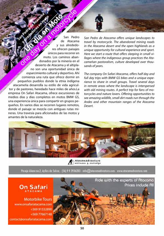
atacameña desarrolla su estilo de vida agricul-tor y de pastoreo, heredado hace miles de años.La
empresa On Safari Atacama, ofrece excursiones de medios días y días completos en motos BMW GS, una experiencia única para compartir en grupos pe-queños. En varios días se recorren lugares remotos, donde el paisaje se mezcla con antiguas rutas mi-neras. Una travesía para aficionados de las motos y amantes de la naturaleza.
San Pedro de Atacama offers unique landscapes to travel by motorcycle. The abandoned mining roads in the Atacama desert and the open highlands as a unique opportunity for cultural experience and sport. Here we start a route that offers sleeping in small vi-llages where the indigenous group practices the Ata-cameñan pastoralism, culture developed over thou-sands of years.
The company On Safari Atacama, offers half day and full day trips with BMW GS bikes and a unique expe-rience to share in small groups. Travel several days in remote areas where the landscape is interspersed with old mining routes. A perfect trip for fans of mo-torcycles and nature lovers. Offering opportunities to see amazing wildlife, small dirt roads run through the Andes and other mountain ranges of the Atacama Desert.
San Pedro de Ata
cama
y alrededore
s en moto
Un día en
Moto
one d
ay on
a moto
rcycle
50
Montañismomountaineering
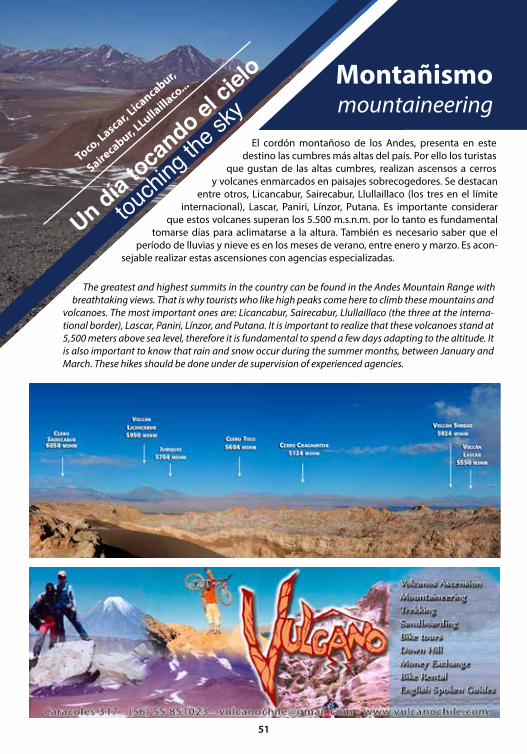
El cordón montañoso de los Andes, presenta en este destino las cumbres más altas del país. Por ello los turistas
que gustan de las altas cumbres, realizan ascensos a cerros y volcanes enmarcados en paisajes sobrecogedores. Se destacan
entre otros, Licancabur, Sairecabur, Llullaillaco (los tres en el límite internacional), Lascar, Paniri, Línzor, Putana. Es importante considerar
que estos volcanes superan los 5.500 m.s.n.m. por lo tanto es fundamental tomarse días para aclimatarse a la altura. También es necesario saber que el
período de lluvias y nieve es en los meses de verano, entre enero y marzo. Es acon-sejable realizar estas ascensiones con agencias especializadas.
The greatest and highest summits in the country can be found in the Andes Mountain Range with breathtaking views. That is why tourists who like high peaks come here to climb these mountains and
volcanoes. The most important ones are: Licancabur, Sairecabur, Llullaillaco (the three at the interna-tional border), Lascar, Paniri, Línzor, and Putana. It is important to realize that these volcanoes stand at 5,500 meters above sea level, therefore it is fundamental to spend a few days adapting to the altitude. It is also important to know that rain and snow occur during the summer months, between January and March. These hikes should be done under de supervision of experienced agencies.
Toco, Lascar, L
icancabur,
Sairecabur, L
Lullailla
co...
Un día toca
ndo el ci
elo
touchi
ng th
e sky
51
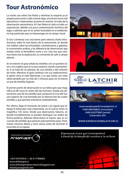
Tour AstronómicoLa noche cae sobre San Pedro y mientras la mayoría ya se prepara para cenar o salir a tomar algo, uno de los tours más educativos e interesantes se pone en marcha. Se trata de la observación astronómica. En San Pedro el cielo es todo un espectáculo, debido a la poca contaminación lumínica del lugar y además que al no existir humedad en el ambiente, no hay partículas que se interpongan en el campo visual.
El tour comienza con una breve pero intensa charla intro-ductoria, sobre lo más básico de la astronomía, en donde nos hablan sobre las principales constelaciones y galaxias, la cosmovisión andina, y las diferencia de observación que existen entre el hemisferio norte y sur. Una vez que esta-mos listos tras la explicación, es momento de salir a campo abierto.
En el exterior el guía señala las estrellas con un puntero la-ser y nos explica qué es lo que estamos viendo exactamen-te, si se trata de un planeta, de una estrella o del cinturón de orión. Mientras el guía continúa con sus explicaciones, la gente mira el cielo fijamente, y es que basta con estar observándolo por no más de 5 minutos para ver al menos un par de estrellas fugaces.
El primer punto de observación es un telescopio que mag-nifica en 80 veces la visión del ojo humano. Desde acá ob-servamos una de las estrellas que compone la Cruz del Sur, una especie de cruz formada por la intersección de cuatro estrellas y que permite orientarse cardinalmente.
Por último, llega el momento de entrar a la cúpula que al-berga el telescopio más importante, en el cual la visión se magnifica 150 veces. Desde acá observamos Saturno, en donde increíblemente se pueden distinguir sus anillos de forma perfecta. Además observamos el Joyero, que es un cumulo de estrellas que parecen precisamente joyas. Final-mente veremos Marte y otros astros antes de terminar el recorrido en la cúpula.
52
Night falls on San Pedro and while most are getting re-ady for dinner or going out for drinks, one of the most educational and interesting tours begins; the astrono-mical observation tour. In San Pedro, the sky itself is a show, due to its location, it has low light pollution and the absence of moisture in the air prevents particles from obstructing the visual field.
The tour begins with a brief but intense introductory lecture on the basics of astronomy where we talk about the major constellations and galaxies, the An-dean comic view, and the observational difference between the northern and southern hemispheres. Once we are ready after the lecture, it’s time to go out-side.
Outside, the guide points out the stars with a laser pointer and tells us exactly what we’re looking at, regarding a planet or a star in Orion’s belt. While the guide continues with his explanation as you look up at the still sky, you need not wait five minutes to see at least a couple of shooting stars.
The first point of observation is a telescope that mag-nifies 80 times the human eye. From here we see one of the stars that makes up the Southern Cross, a kind of cross formed by the intersection of four stars and helps you to orient yourself with respect to the cardi-nal points.
Finally, it is time to enter the dome that houses the largest telescope in which the view is magnified 150 times. From here we see Saturn, where incredibly you can distinguish its rings perfectly. We can also see a cluster of stars known as the Jewelry Box, named this because of its resemblance to sparkling jewelry. And last but not least, we see Mars and other planets befo-re ending the tour in the dome.
Duración /Duration: 3 hrs
Altura máxima / Maximum altitu-de: 2,500 m.s.n.m
Recomendaciones / Tips: Llevar parka y agua mineral / Take a jacket and bottled water.
+ Video
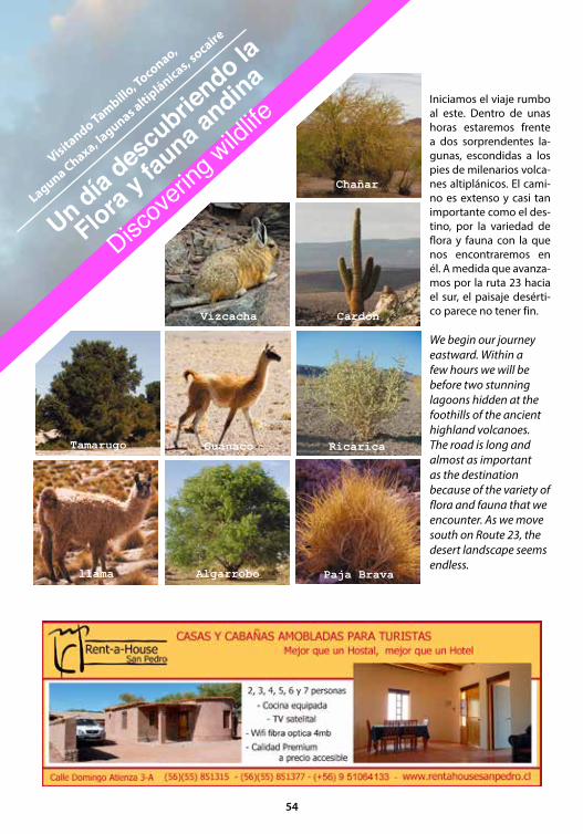
Iniciamos el viaje rumbo al este. Dentro de unas horas estaremos frente a dos sorprendentes la-gunas, escondidas a los pies de milenarios volca-nes altiplánicos. El cami-no es extenso y casi tan importante como el des-tino, por la variedad de flora y fauna con la que nos encontraremos en él. A medida que avanza-mos por la ruta 23 hacia el sur, el paisaje desérti-co parece no tener fin.
We begin our journey eastward. Within a few hours we will be before two stunning lagoons hidden at the foothills of the ancient highland volcanoes. The road is long and almost as important as the destination because of the variety of flora and fauna that we encounter. As we move south on Route 23, the desert landscape seems endless.
Visitando Tambillo
, Toconao,
Laguna Chaxa, lagunas altip
lánicas, socaire
Un día des
cubrie
ndo la
Flora y f
auna a
ndina
Discove
ring w
ildlife
Vizcacha Cardón
Chañar
Tamarugo Guanaco
llama Algarrobo Paja Brava
Ricarica
54
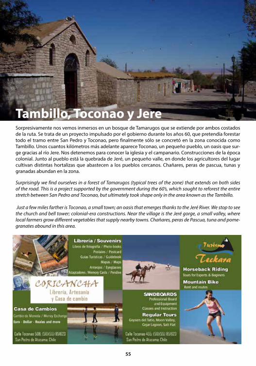
Sorpresivamente nos vemos inmersos en un bosque de Tamarugos que se extiende por ambos costados de la ruta. Se trata de un proyecto impulsado por el gobierno durante los años 60, que pretendía forestar todo el tramo entre San Pedro y Toconao, pero finalmente sólo se concretó en la zona conocida como Tambillo. Unos cuantos kilómetros más adelante aparece Toconao, un pequeño pueblo, un oasis que sur-ge gracias al río Jere. Nos detenemos para conocer la iglesia y el campanario. Construcciones de la época colonial. Junto al pueblo está la quebrada de Jeré, un pequeño valle, en donde los agricultores del lugar cultivan distintas hortalizas que abastecen a los pueblos cercanos. Chañares, peras de pascua, tunas y granadas abundan en la zona.
Surprisingly we find ourselves in a forest of Tamarugos (typical trees of the zone) that extends on both sides of the road. This is a project supported by the government during the 60’s, which sought to reforest the entire stretch between San Pedro and Toconao, but ultimately took shape only in the area known as the Tambillo.
Just a few miles farther is Toconao, a small town; an oasis that emerges thanks to the Jeré River. We stop to see the church and bell tower; colonial-era constructions. Near the village is the Jeré gorge, a small valley, where local farmers grow different vegetables that supply nearby towns. Chañares, peras de Pascua, tuna and pome-granates abound in this area.
Tambillo, Toconao y Jere
55
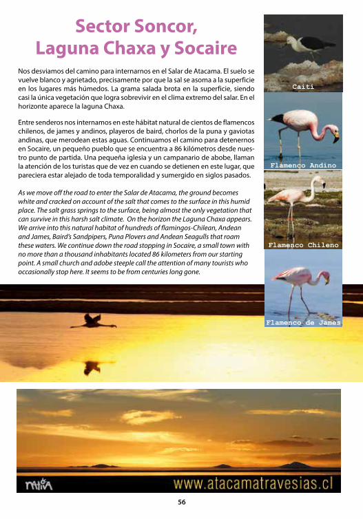
Sector Soncor, Laguna Chaxa y Socaire
Nos desviamos del camino para internarnos en el Salar de Atacama. El suelo se vuelve blanco y agrietado, precisamente por que la sal se asoma a la superficie en los lugares más húmedos. La grama salada brota en la superficie, siendo casi la única vegetación que logra sobrevivir en el clima extremo del salar. En el horizonte aparece la laguna Chaxa.
Entre senderos nos internamos en este hábitat natural de cientos de flamencos chilenos, de james y andinos, playeros de baird, chorlos de la puna y gaviotas andinas, que merodean estas aguas. Continuamos el camino para detenernos en Socaire, un pequeño pueblo que se encuentra a 86 kilómetros desde nues-tro punto de partida. Una pequeña iglesia y un campanario de abobe, llaman la atención de los turistas que de vez en cuando se detienen en este lugar, que pareciera estar alejado de toda temporalidad y sumergido en siglos pasados.
As we move off the road to enter the Salar de Atacama, the ground becomes white and cracked on account of the salt that comes to the surface in this humid place. The salt grass springs to the surface, being almost the only vegetation that can survive in this harsh salt climate. On the horizon the Laguna Chaxa appears. We arrive into this natural habitat of hundreds of flamingos-Chilean, Andean and James, Baird’s Sandpipers, Puna Plovers and Andean Seagulls that roam these waters. We continue down the road stopping in Socaire, a small town with no more than a thousand inhabitants located 86 kilometers from our starting point. A small church and adobe steeple call the attention of many tourists who occasionally stop here. It seems to be from centuries long gone.
Caití
Flamenco Andino
Flamenco Chileno
Flamenco de James
56
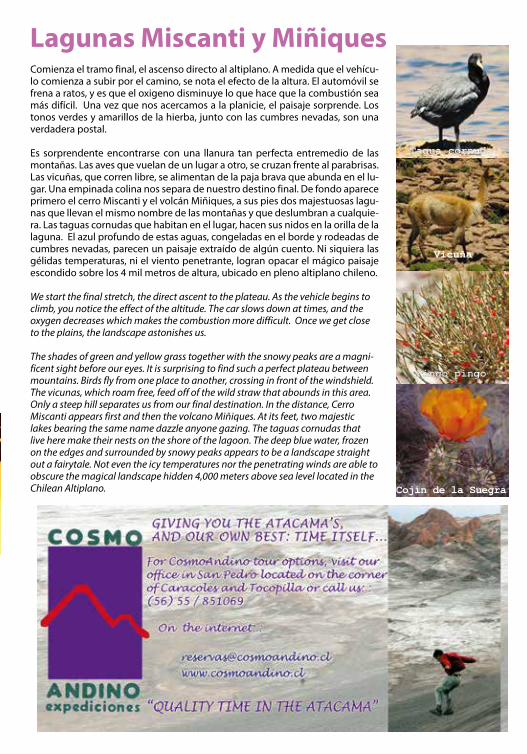
Lagunas Miscanti y MiñiquesComienza el tramo final, el ascenso directo al altiplano. A medida que el vehícu-lo comienza a subir por el camino, se nota el efecto de la altura. El automóvil se frena a ratos, y es que el oxigeno disminuye lo que hace que la combustión sea más difícil. Una vez que nos acercamos a la planicie, el paisaje sorprende. Los tonos verdes y amarillos de la hierba, junto con las cumbres nevadas, son una verdadera postal.
Es sorprendente encontrarse con una llanura tan perfecta entremedio de las montañas. Las aves que vuelan de un lugar a otro, se cruzan frente al parabrisas. Las vicuñas, que corren libre, se alimentan de la paja brava que abunda en el lu-gar. Una empinada colina nos separa de nuestro destino final. De fondo aparece primero el cerro Miscanti y el volcán Miñiques, a sus pies dos majestuosas lagu-nas que llevan el mismo nombre de las montañas y que deslumbran a cualquie-ra. Las taguas cornudas que habitan en el lugar, hacen sus nidos en la orilla de la laguna. El azul profundo de estas aguas, congeladas en el borde y rodeadas de cumbres nevadas, parecen un paisaje extraído de algún cuento. Ni siquiera las gélidas temperaturas, ni el viento penetrante, logran opacar el mágico paisaje escondido sobre los 4 mil metros de altura, ubicado en pleno altiplano chileno.
We start the final stretch, the direct ascent to the plateau. As the vehicle begins to climb, you notice the effect of the altitude. The car slows down at times, and the oxygen decreases which makes the combustion more difficult. Once we get close to the plains, the landscape astonishes us.
The shades of green and yellow grass together with the snowy peaks are a magni-ficent sight before our eyes. It is surprising to find such a perfect plateau between mountains. Birds fly from one place to another, crossing in front of the windshield. The vicunas, which roam free, feed off of the wild straw that abounds in this area.Only a steep hill separates us from our final destination. In the distance, Cerro Miscanti appears first and then the volcano Miñiques. At its feet, two majestic lakes bearing the same name dazzle anyone gazing. The taguas cornudas that live here make their nests on the shore of the lagoon. The deep blue water, frozen on the edges and surrounded by snowy peaks appears to be a landscape straight out a fairytale. Not even the icy temperatures nor the penetrating winds are able to obscure the magical landscape hidden 4,000 meters above sea level located in the Chilean Altiplano.
Vicuña
Tagua cornuda
Pingo pingo
Cojín de la Suegra
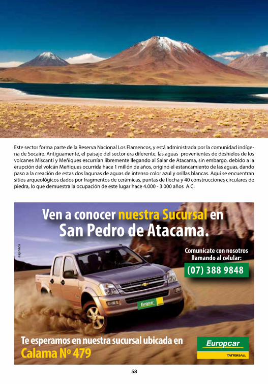
Este sector forma parte de la Reserva Nacional Los Flamencos, y está administrada por la comunidad indíge-na de Socaire. Antiguamente, el paisaje del sector era diferente, las aguas provenientes de deshielos de los volcanes Miscanti y Meñiques escurrían libremente llegando al Salar de Atacama, sin embargo, debido a la erupción del volcán Meñiques ocurrida hace 1 millón de años, originó el estancamiento de las aguas, dando paso a la creación de estas dos lagunas de aguas de intenso color azul y orillas blancas. Aquí se encuentran sitios arqueológicos dados por fragmentos de cerámicas, puntas de flecha y 40 construcciones circulares de piedra, lo que demuestra la ocupación de este lugar hace 4.000 - 3.000 años A.C.
58

Duración /Duration: Todo el día / full day (8 am a /to 18:00 pm)
Distancia / Distance: 270 kms ida y vuelta / 270 kms round trip
Altura máxima / Maximum altitude: 4,900 m.s.n.m
Recomendaciones / Tips: Llevar parka, protector so-lar y agua mineral / Take a jacket, sunscreen and bottled water.
+ Video
This area forms part of the Flamenco National Re-serve, and the native community of Socaire ma-nages it. The landscape was different in the past with the thawing waters from the Miscanti and Meñiques volcanoes running freely down to the Atacama Salt Flats. However, the eruption of the Meñiques Volcano 1 million years ago resulted in the stagnation of water thus forming these two intense blue water lagoons surrounded by white banks. Several archeological sites are found in this area containing ceramic fragments, arrow heads, and 40 circular stone constructions that stand as proof of an existing population around 3,000 - 4,000 B.C.
Un día ca
ballo: E
l Tunel
one d
ay rid
ing
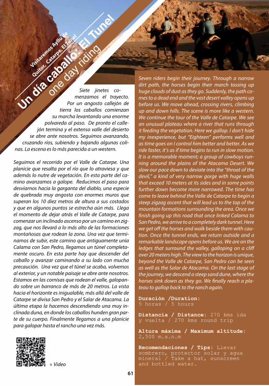
Siete jinetes co-menzamos el trayecto.
Por un angosto callejón de tierra los caballos comienzan
su marcha levantando una enorme polvareda al paso. De pronto el calle-
jón termina y el extenso valle del desierto se abre ante nosotros. Seguimos avanzando,
cruzando ríos, subiendo y bajando algunas coli-nas. La escena es lo más parecida a un western.
Seguimos el recorrido por el Valle de Catarpe. Una planicie que resalta por el río que lo atraviesa y que además lo nutre de vegetación. En esta parte del ca-mino avanzamos a galope. Reducimos el paso para desviarnos hacia la garganta del diablo, una especie de quebrada muy angosta con enormes muros que superan los 10 diez metros de altura a sus costados y que en algunos puntos se estrecha aún más. Llega el momento de dejar atrás el Valle de Catarpe, para comenzar un inclinado ascenso por un camino en zig-zag, que nos llevará a lo más alto de las formaciones montañosas que rodean la zona. Una vez que termi-namos de subir, este camino que antiguamente unía Calama con San Pedro, llegamos un túnel completa-mente oscuro. En esta parte hay que descender del caballo y avanzar caminando a su lado con mucha precaución. Una vez que el túnel se acaba, volvemos al exterior, y un notable paisaje se abre ante nosotros. Estamos en las cornisas que rodean el valle, galopan-do sobre un barranco de más de 20 metros. La vista hacia el horizonte es inigualable, más allá del valle de Catarpe se divisa San Pedro y el Salar de Atacama. La última etapa la hacemos descendiendo una muy in-clinada duna, en donde los caballos hunden gran par-te de su cuerpo. Finalmente llegamos a una planicie para galopar hasta el rancho una vez más.
Duración /Duration: 5 horas / 5 hours
Distancia / Distance: 270 kms ida y vuelta / 270 kms round trip
Altura máxima / Maximum altitude: 2,500 m.s.n.m
Recomendaciones / Tips: Llevar sombrero, protector solar y agua mineral / Take a hat, sunscreen and bottled water.
Visitaremos Ayllu
de
Quitor,
Catarpe, E
l Tunel
Un día ca
ballo: E
l Tunel
one d
ay rid
ing
Seven riders begin their journey. Through a narrow dirt path, the horses begin their march tossing up huge clouds of dust as they go. Suddenly, the path co-mes to a dead end and the vast desert valley opens up before us. We move ahead, crossing rivers, climbing up and down hills. The scene is more like a western. We continue the tour of the Valle de Catarpe. We see an unusual plateau where a river that runs through it feeding the vegetation. Here we gallop. I don’t hide my inexperience, but “Eighteen” performs well and as time goes on I control him better and better. As we ride faster, it’s as if time begins to run in slow motion. It is a memorable moment; a group of cowboys run-ning around the plains of the Atacama Desert. We slow our pace down to deviate into the “throat of the devil,” a kind of very narrow gorge with huge walls that exceed 10 meters at its sides and in some points further down become more narrowed. The time has come to leave behind the Valle de Catarpe to begin a steep zigzag ascent that will lead us to the top of the mountain formations surrounding the area. Once we finish going up this road that once linked Calama to San Pedro, we arrive to a completely dark tunnel. Here we get off the horses and walk beside them with cau-tion. Once the tunnel ends, we return outside and a remarkable landscape opens before us. We are on the ledges that surround the valley, galloping on a cliff over 20 meters high. The view to the horizon is unique, beyond the Valle de Catarpe, San Pedro can be seen as well as the Salar de Atacama. On the last stage of the journey, we descend a steep sand dune, where the horses sink down as they go. We finally reach a pla-teau to gallop back to the ranch again.
+ información+ Video
61
Valle del Arcoiris
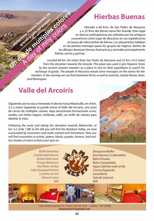
Hierbas Buenas
Siguiendo por la ruta y tomando el desvío hacia Matancilla, en el km. 3,2 a mano izquierda se puede entrar al Valle del Arcoíris, una zona de cerros de múltiples colores. Aquí encontrarás formaciones ocres, verdes, con tintes negros, violáceas, cafés, un sinfín de colores para deleitar la vista.
Following the route and taking the deviation towards Matancilla, at km 3.2 (mile 1.98) to the left you will find the Rainbow Valley, an area surrounded by mountains and multi-colored rock formations. Here you will find mountains in ochres, greens, blacks, purples, browns, and end-less shades of colors to feast your eyes on.
Ubicado a 68 Kms. de San Pedro de Atacama, y a 23 Kms del desvío hacia Río Grande, Este lugar
en épocas prehispánicas era utilizado por los antiguos caravaneros como lugar de descanso en sus expediciones
en busca de intercambio de bienes. Los atacameños tallaban en las piedras mensajes paras los grupos de viajeros, dentro de
los dibujos destacan formas shamanicas y animales principalmente llamas, zorros y parinas.
Located 68 km (42 miles) from San Pedro de Atacama and 23 km (14.3 miles) from the deviation towards Rio Grande. This place was used in pre-Hispanic times
by the ancient caravan travelers as a place to rest on their expeditions in search for exchange of goods. The people of Atacama would carve messages on the stones for the
travelers. In the carvings we can find shamanic forms as well as animals, mainly llamas, foxes and flamingoes.
Visitaremos hierb
as buenas, rio
grande y valle del a
rcoíris
Un día de m
últiples
colores
A day o
f mny
colors
62

Río GrandeEn la cuenca del Río Grande, a 90 kms de San Pedro de Atacama, en dirección a Calama, este poblado con alrededor de 96 habitantes, tenía una ubicación estratégica como paso obligado de las caravanas que se desplazaban entre San Pedro de Atacama y Chiu-Chiu. Lo que se puede constatar gracias a los sitios arqueológicos de su entorno, principalmente petroglifos de cazadores de guanacos en tiempos prehispánicos.
Hoy en día, sus pobladores se dedican al cultivo de maíz, lechugas, alfalfa, papas entre otros y también a la crianza de ovejas, llamas, aves, conejos y cabras, los cuales son comercializados en su gran mayoría en Calama. También existe la elaboración de tejidos y artesanía en menor grado.
La construcción de Río Grande, se caracteriza por el uso de de piedras canteadas en sus muros, unidas con argamasa de barro, techos de paja y barro con vigas de madera de cactus y algarrobo.
Tiempo de duración / Duration: 1/2 día / Half Day
Distancia / Dstance: 160 km ida y vuelta / 160 kms round trip
Altura máxima/Maximum Atlitude: 3,200 m.s.n.m
Recomendaciones / Tips: Llevar snack, agua mineral, cortaviento, vehículo alto o 4x4. / Take a snack, bottled water, a windbreaker, a high or 4WD vehicle.
In the basin of the “big river”, 90 kilometers from San Pedro de Atacama, towards Calama, lies this village with a population of around 96 inhabitants. Its loca-tion was strategic, as it was the forced passageway for caravans traveling between San Pedro de Atacama and Chiu-Chiu. Evidence of this is the surrounding archeological sites that show petroglyphs of the gua-naco hunters during the pre-Hispanic period. Today, Rio Grande’s settlers cultivate corn, lettuce, alfalfa, potatoes, as well as raise sheep, llamas, birds, rabbits, and goats, which are marketed in Calama. They also manufacture textile and handmade goods on a lower scale. Construction in Rio Grande is characterized by the use of quarry stone on the walls joined together by mortar clay, straw and clay roofs with cactus and carob beams.
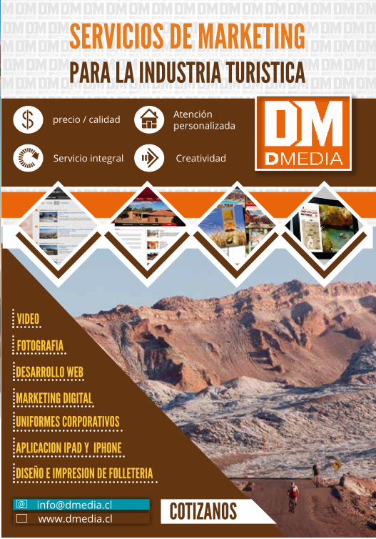
precio / calidad
Servicio integral
@
www.dmedia.cl Cotizanos
serviCios de Marketing Para la industria turistiCa
Atención personalizada
Creatividad
Marketing digital
aPliCaCion iPad y iPhone
uniforMes CorPorativos
diseño e iMPresion de folleteria
desarrollo web
fotografia
video
dmedia g16.indd 1 3/5/2013 12:22:00 AM
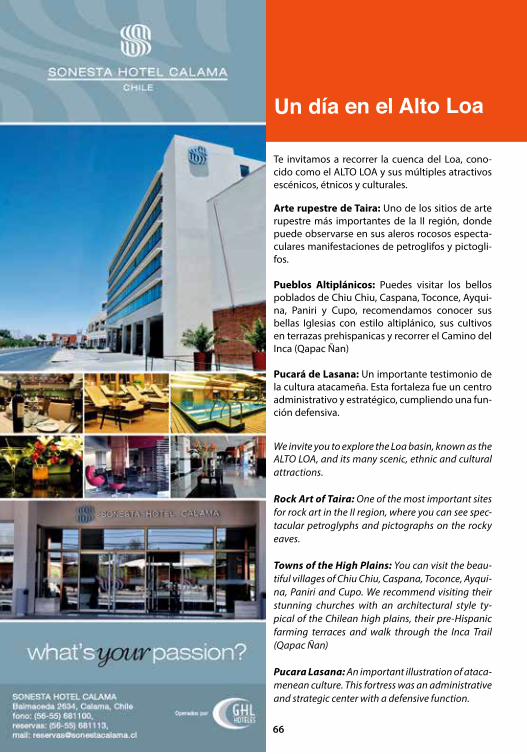
Un día en el Alto Loa
Te invitamos a recorrer la cuenca del Loa, cono-cido como el ALTO LOA y sus múltiples atractivos escénicos, étnicos y culturales.
Arte rupestre de Taira: Uno de los sitios de arte rupestre más importantes de la II región, donde puede observarse en sus aleros rocosos especta-culares manifestaciones de petroglifos y pictogli-fos.
Pueblos Altiplánicos: Puedes visitar los bellos poblados de Chiu Chiu, Caspana, Toconce, Ayqui-na, Paniri y Cupo, recomendamos conocer sus bellas Iglesias con estilo altiplánico, sus cultivos en terrazas prehispanicas y recorrer el Camino del Inca (Qapac Ñan)
Pucará de Lasana: Un importante testimonio de la cultura atacameña. Esta fortaleza fue un centro administrativo y estratégico, cumpliendo una fun-ción defensiva.
We invite you to explore the Loa basin, known as the ALTO LOA, and its many scenic, ethnic and cultural attractions.
Rock Art of Taira: One of the most important sites for rock art in the II region, where you can see spec-tacular petroglyphs and pictographs on the rocky eaves.
Towns of the High Plains: You can visit the beau-tiful villages of Chiu Chiu, Caspana, Toconce, Ayqui-na, Paniri and Cupo. We recommend visiting their stunning churches with an architectural style ty-pical of the Chilean high plains, their pre-Hispanic farming terraces and walk through the Inca Trail (Qapac Ñan)
Pucara Lasana: An important illustration of ataca-menean culture. This fortress was an administrative and strategic center with a defensive function.
66

Mina Chuquicamata: Es la mina de cobre más grande del mundo. Se puede visitar el campamento minero y una espectacular vista al yacimiento a tajo abierto, donde todo es gigante.Las visitas se reali-zan de lunes a viernes, excepto festivos, en horarios de 14.00 y 15.00 horas. Para realizar las reservas, los interesados pueden llamar a los fonos 322122 o al 322786 o a través del mail [email protected]. Es importante señalar que los visitantes deben asistir con ropa cerrada, tanto pantalones como en camisa y zapatos.
Observatorio de Arqueoastronomía Andina: La mejor forma de terminar tú recorrido por el alto loa es visitando el observatorio de astronomía Andina “Panirir Caur”.
Ubicado en el pueblo de Chiu Chiu, una experien-cia única que conjuga la astronomía occidental con la cosmovisión de los atacameños, abarcando un aspecto de la historia que nos permite conocer la incidencia que tenían el cielo, el sol y las estrellas en toda la estructura de vida de los lickan antay.
Un día en el Alto Loa
Chuquicamata Mine: This is the world’s largest cop-per mine. You can visit the miner’s camp and a spec-tacular view to the open pit deposit, where everything is massive.
Tours are conducted Monday through Friday, exclu-ding holidays, at 14.00 hours and 15.00 hours. To make reservations, those interested can call 322122 or 322786 phones or through the [email protected] mail. Importantly, visitors must go with closed clothes, pants as well shirt and shoes.
Andean Observatory Archaeoastronomy: The best way to finsi your journey through the Alto Loa is to visit the Andean astronomy observatory, “Panirir Caur”.
Located in the village of Chiu Chiu, an unique astro-nomy experience that combines the Western world view with the Atacama traditions, covering an aspect of history that allows us to know the impact that had the sky, the sun and stars in the whole structure of life
67
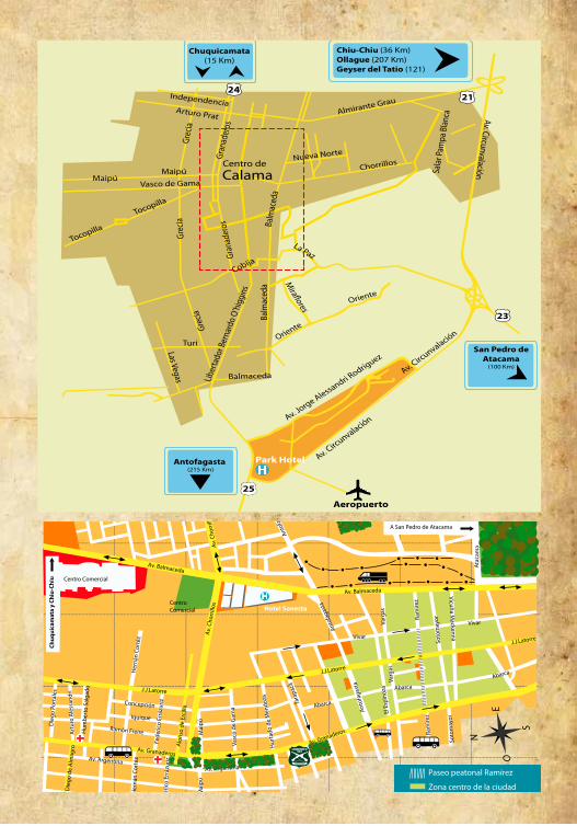
Antofagasta(215 Km)
Park Hotel
Aeropuerto
Centro de
A San Pedro de Atacama
Hotel Sonesta

LINEA AEREA / AIRLINE
PAL AIRLINEwww.palair.cl
LAN CHILEwww.lan.com
SKY AIRLINESwww.skyairline.cl
TRANSFER
TRANSFER LICANCABUR+5655 543426 / +569 9999404 [email protected]
BUSES INTERNACIONALES / INTERNAT. BUS
BUSES GEMINIS +5655 851538 / Toconao 421, SPA
PULLMAN BUSwww.pullman.cl
BUSES NACIONALES / NATIONAL BUS
INTERTRANSLicancabur s/n +569 96228034
TUR BUS (Todo Chile)www.turbus.cl
BUSES FRONTERA (Calama-SPA)+5655 851117 Licancabur s/n, SPA
ATACAMA 2000 (Calama-SPA)+5655 851501 Licancabur s/n, SPA
ARRIENDO VEHICULOS
EUROPCARCalama 479 - San Pedro de Atacamawww.europcar.cl / 600 9399000celular: +569 7 3889848
TAXI
TAXI MICHEA (SPA)+569 68394588
TAXI CONDOR (SPA)+569 82366111 / +569 84402454
ARRIENDO DE CAMPERS
WICKED CAMPERSwickedsouthamerica.com +569 91383372
CASA DE CAMBIO /MONEY EXCHANGE
CORICANCHACalle Toconao 508 / +5655 851623
BABALUCalle Caracoles 160
GIANNI MAZZETTIToconao 552-A, + 5655 852137
INTERNET
GIANNI MAZZETTIToconao 552-A
MASAJES
CKMURIA MULEYLos algarrobos 155+569 87628611 / +569 94336855
VESTUARIO Y ACCESORIOS
ROCKFORDCaracoles 320
ARTESANIA / HANDCRAFT
ATACAMEÑAToconao 441 C/ +569 87930245
METALARTGustavo le Paige 151/ +5655 851020
AGENCIAS DE TURISMO
ALTIPLANO AVENTURACaracoles 174 A+569 8485928 / +5655 852107altiplanoaventuratours@gmail.comwww.altiplanoaventurachile.cl
GRADO 10Toconao 435 - A, +5655 560600 / +569 [email protected]
EXPEDICIONES CORVATSCHTocopilla 406 / +5655 [email protected]
DESERT ADVENTURECaracoles esq. Tocopilla,SPA / +5655 851067 [email protected]
ALTUTUD AVENTURAToconao 441-E / +569 [email protected]
COSMO ANDINOCaracoles s/n, +5655 [email protected]
LAYANATocopilla 429-B+5655 560233, +569 90893109 [email protected]
AYLLU EXPEDICIONESCalle Toconao 479+5655 592781 / +569 [email protected], www.ayllu.cl
VULCANOCaracoles 317 / +5655 [email protected]
MAXIM EXPERIENCECaracoles 174-C(56)(55) 424724- (56)(09) [email protected]
SANPEDRODEATACAMACHILE.COMCaracoles esq. Domingo Atienza+569 82441251reservas@sanpedrodeatacamachile.clwww.sanpedrodeatacamachile.cl
CKONTOR ADVENTUREGustavo le Paige 230+569 66673271/ +569 [email protected]
INCACOYAToconao 474+5655 851363 [email protected]
NATIVA - TRAVESÍAS EN ATACAMA+569 9996584 www.atacamatravesias.cl
TURISMO TECKARAToconao 455 / +5655 851623
TURISMO CAURVilama [email protected]@gmail.com+5655 560253 / +569 56184976
LATCHIR EXPEDICIONESCaracoles 254, +569 89049804reservas@expedicioneslatchir.clwww.expedicioneslatchir.cl
ANDESTRAVELCaracoles [email protected]+5655 574785 / +569 982459465
HELADERIA / GELATO
TIERRA DE SOLCalama 451, esquina Caracoles
BABALUCalle Caracoles 160, Caracoles 419
LIBRERIA / LIBRARY
CORICANCHACalle Toconao 508 / +5655 851623
GUIAS / GUIDES
El Arriero - Bernardo Flores+569 [email protected]
Zahel Quezada+569 99996584 [email protected]
LAVANDERIA/ LAUNDRY
VIENTO NORTEPasaje Vilama 432 -B / +5655 851329www.vientonortechile.cl
ARRIENDO DE SANDBOARD Y BICICLETA
ALTUTUD AVENTURAToconao 441-E / +569 87745947
TURISMO TECKARAToconao 455 / +5655 851623
PIRATE ADVENTUREToconao 421-a+5655 851062 / +56 81351675www.sandboardsanpedro.com
ASCENCIÓN A VOLCANES
COSMO ANDINO EXPEDICIONESCaracoles s/n / +5655 [email protected]
EXPEDICIONES CORVATSCHTocopilla 406 / +5655 [email protected]
VULCANOCaracoles 317 / +5655 [email protected]
CABALGATA/ HORSEBACKRIDING
RANCHO CACTUSCalle Toconao 568 / +5655 [email protected]
EL ARRIERO+569 [email protected]
TURISMO TECKARAToconao 455, +5655 851623
ATACAMA HORSE ADVENTURETocopilla 406 / +5655 851956info@atacamahorseadventure.comwww.atacamahorseadventure.com
TOURS EN MOTO
ON SAFARIwww.onsafariatacama.com+569 91532890 / +569 [email protected]
ARRIENDO CASA RODANTE CAMPERS RENTAL
WICKEDwww.wickedsouthamerica.com+569 91383372
TURISMO ASTRONOMICO
AHLARKAPIN+569 95797816 / +569 77498405www.ahlarkapin.clwww.ahlarkapinobservatorio.blogspot.com
Directorio / Directory
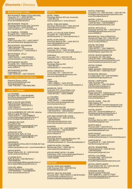
HOTELES
HOTEL KIMALDomingo Atienza 452 esq. Caracoles+5655 [email protected] / www.kimal.cl
HOTEL POBLADO KIMALDomingo Atienza 452 / +5655 [email protected]
HOTEL LA CASA DE DON TOMASTocopilla 18 / +5655 [email protected] / www.dontomas.cl
HOTEL ALTIPLANICODomingo Atienza 282 / +5655 [email protected]
HOTEL TAKHA- TAKHACaracoles 101-A / +5655 [email protected] / www.takhatakha.cl
DON RAULCaracoles 130 / +5655 [email protected] / www.donraul.cl
HOTEL TULORDomingo Atienza 563+5655 [email protected] / www.tulor.cl
HOTEL CORVATSCHLicancabur 191 / +5655 [email protected]
JIREHCalama 224+5655 569805 / +5655 851932 www.hoteljireh.cl / [email protected]
GEISER DEL TATIOCaracoles 219 / [email protected]+5655 851263 / +5655 569800
LA COCHERATocopilla 482 +5655 566372 / +569 [email protected]
HOTEL CASA SOLCORAntonio León s/n Ayllu de Solcor+569 94337070 / +5655 [email protected] / www.casasolcor.cl
ATACAMA ADVENTURE LODGEPasaje Alana n°2 - Ayllu de Solcor+569 [email protected]
RUKAZENAv. Sequitor nº 38 / +569 98200954+569 91281831 / +569 [email protected]
DON SEBASTIANDomingo Atienza pasaje Mutulera 140+5655 851972 / +5655 [email protected] / www.donsebastian.cl
SONESTA HOTEL CALAMABalmaceda 2634 / +5655 [email protected]
AYELEN APART HOTEL CALAMASotomayor 2397/ [email protected]+5655 362021
HOSTALES
HOSTAL EDEN ATACAMEÑOCalle Toconao 592 / +5655 [email protected]
HOSTAL CRUZ DE ATACAMAToconao 594 / +5655 590335 /+569 [email protected]
HOSTAL PURITAMACaracoles 113, +5655 851540 / +5655 [email protected]
HOSTAL LA RUCAToconao 513 / www.larucahostal.cl+5655 851568 / +569 [email protected]
HOSTAL INTI & KILLADomingo Atienza 294 / +5655 [email protected]
RESIDENCIAL CASA CORVATSCHGustavo le Paige 178 / +5655 [email protected]
HOSTAL INTI PARACalle Tocopilla 331+5655 851221 / +569 78880333intipara@sanpedroatacama.comhostalintipara.supersitio.net
HOSTAL NUEVO AMANECERLos Geysers 161, Alto Jama+5655 851348 / +569 62098626 [email protected]
HOSTAL PURIKOLincabur204 [email protected]+5655 851392 / +5609 66572237
ECOHOSTAL REFUGIOLos algarrobos 155/ +569 [email protected]
HOSTAL CAMPO BASECalle Toconao 535+5655 851472 / +569 [email protected]
HOSTAL CHAXAPasaje Jama 673 - Población Licancabur+5655 851340 / +569 84648590 [email protected] www.hostalchaxa.cl
HOSTAL RURAL - THE LIFECalle Calama 257+569 75712844 / [email protected]@hostalrural.cl / www.hostalrural.cl
HOSTAL DESERTJama 743 / [email protected]+5655 560339 /+5655 560340
CHILOEDomingo Atienza 404 / +5655 [email protected]
QUINTA ADELAToconao 624 / +5655 851272www.quintaadela.wix.com/[email protected]
HOIRI CKUNZATocopilla 318/ +5655 [email protected] / www.hoirickunza.cl
HARICKUNTURTocopilla 8F-A / +569 [email protected]
HOSTAL MAMATIERRAPachamama 615/ +5655 851418+569 [email protected]
HOSTAL LA FLORIDATocopilla 406/ +5655 851021www.hostalflorida.cl [email protected]
HOSTAL VIENTO NORTEPasaje Vilama 432 -B / +5655 851329www.vientonortechile.cl
TOWANDA HOSTELIgnacio Carrera Pinto 633+569 76068787 / +569 [email protected]
Directorio / Directory
RESTAURANTES Y CAFES
RESTAURANTE TIERRA TODO NATURALCaracoles 271 / +5655 [email protected]
RESTAURANTE PAACHADomingo Atienza 452 esq. Caracoles+5655 851524 / +5655 851030 [email protected] / www.kimal.cl
EL CHARRUA - PIZZERÍATocopilla 442 / +5655 [email protected]
BARROSCalle Licancabur 252 / +5655 [email protected]
RESTAURANTE PACHAKONACalle Caracoles 163 +5655 851030 / +5655 [email protected] / www.kimal.cl
RESTAURANTE AYLLUToconao 479+5655 592781 / +569 [email protected] / www.ayllu.cl
RESTAURANTE SOLINTITocopilla 130 / +5655 [email protected]
RESTAURANTE QUITORLicancabur 154+569 72018102 / +569 72016752
VENTA PRODUCTOS NATURALES
Emporio Queso y [email protected]+569 77927645 / +569 98051893
CASAS Y CABAÑAS
LA COCHERATocopilla 482 / +569 [email protected]
RENT A HOUSE SAN PEDROCalle Domingo Atienza 3-A+5655 851315 / +5655 851377, +569 51064133www.rentahousesanpedro.cl
LOS ALGARROBOS DE CHECAR, cabañasSelti s/n, ayllu de Checar +5655 423519 / +569 97888033contacto@losalgarrobosdechecar.clwww.losalgarrobosdechecar.cl
CABAÑAS RIO YAYETocopilla # [email protected]+5655 569317 / +569 81389781 / +569 89521895
LODGE RIO YAYEAvenida Selti, Ayllu de [email protected]+5655 569317 / +569 81389781 / +569 89521895
HARAMAKSICircunvalación el Inca sitio A-23,Ayllu de Coyo+569 [email protected] / www.haramaksi.cl
VIENTO NORTEPasaje Vilama 432 -B / +5655 851329www.vientonortechile.cl
LE GRAND BLEUAyllu de Solor ,+569 98276352 /+569 98281581reservas@legrandbleuexpediciones.clwww.legrandbleuexpediciones.cl
CASA DEL ARBOLCallejon Reales esq. Caracoles+569 99996584 / +569 88858197www.atacamatravesias.cl