Embed Size (px)
Citation preview

Final
Knottingley & FerrybridgeDelivery Plan 2012-2015

Contents
Page 2 1. Introduction
Page 3 2. Purpose of the Delivery Plan
Page 4 3. Vision and Objectives
Page 5 4. Action at Strategic Level
Page 11 5. Delivery Programme 2012-2015
Page 16 6. Funding
Page 17 7. Project Management Arrangements
Page 18 8. Action Plan
Appendices
Page 21 Appendix 1 Historical Context
Page 22 Appendix 2 Socio-Economic Profile
Page 27 Appendix 3 Character Zones
Copyright GeoPerspectives 2009

The following key themes for action have been identified by the Steering Group:
Employment, Business and Skills;
Transportation and Highways;
Housing;
Sport/Culture, including Community Facilities;
Town Centre Environment and Public Realm;
Education.
Context
Knottingley has been important historically both in transport terms and for a range of intensive industrial uses, however its growth over the last hundred or so years is typified by a number of large residential estates. These housing areas often lack facilities and do not physically relate well to one another. They surround and engulf older heavy industry which would not be located in the heart of settlements today. The result is a relatively poor urban form where residential areas have poor connectivity to the local centre of the settlement. The Warwick Ahead initiative funded through the Big Lottery provides an opportunity for the local community to shape their neighbourhood and address needs within the Warwick estate over the course of the next 10 years. It is important that other neighbourhoods are also reviewed as part of the character zone analysis moving forward.
The town has dispersed retail and community facilities with no one identifiable town centre. However Knottingley does benefit from the natural assets of the river Aire and the Knottingley Canal which provide an opportunity for environmental improvements and leisure activities.
Knottingley suffers from the impact of heavy traffic, particularly commercial traffic, along the A645 which runs through the Hill Top area of town.
Transport infrastructure is a major geographical constrictor, with the M62 to the south, the River Aire bounding the north and the A1 to the west.
Added to this, a main railway line runs parallel to the A645 through the centre creating an island effect, cutting the town off and hindering movement. Opportunities are presented by the new A1(M) which runs west of Ferrybridge power station. There are also opportunities through new development to improve the pedestrian connectivity of different parts of the town in order to reduce the dominance of the car.
In recent years Knottingley has been prey to economic stagnation, lack of investment, out of town competition, and poor quality new development. The town suffers from high levels of unemployment and high levels of deprivation. Conversely the historic background to the area adjacent to Ferrybridge power station means that there is also a highly skilled engineering background amongst an element of the local workforce which could be utilised. The demise of the chemical industry and the legacy of derelict brownfield land this has created combined with the current and potential future power generation that could be accommodated could provide a USP for Knottingley as a green energy hub.
There are several key employers in the area including SSE and Lafarge at Ferrybridge, ADM Milling, Allied Glass, Ardagh Glass and Stolzle Flacconage in Knottingley and new investors coming forward on the site of the former Oxiris chemical works. A socio-economic profile of the town is provided in Appendix 1.
Consultation to date
Four public consultation events took place in late 2009 and early 2010 including a workshop with young people at the former Knottingley High School (now De Lacey Academy) and feedback from these events has informed the early projects to be implemented. On-going consultation with the community, local stakeholders and businesses will take place as the Delivery Plan and individual projects progress.
The overall long-term vision for Knottingley emerged from the Urban Renaissance Five Towns Strategic Development Framework (SDF), which was prepared in partnership with the community by consultants to the former Yorkshire Forward. The SDF was approved by Wakefield Council and the Towns Team in July 2005 as a broad vision to guide regeneration in the area. In September 2012 the Council adopted the Site Specific Policies Local Plan which forms part of the Local Development Framework (LDF) and approved the Jobs and Growth Plan which sets priorities and a programme of action to stimulate investment in people, places and business across the Wakefield District. There are a number of key employment and housing sites identified within the Local Plan document which will help to form the basis of regeneration in Knottingley.
This Knottingley and Ferrybridge Delivery Plan builds upon the SDF vision to bring forward a coherent set of deliverable development and economic growth proposals to attract private sector investment, improve the environment and benefit the community whilst reflecting the prevailing downturn in the economic climate and the new National Planning Policy Framework background. It will identify opportunities for encouraging and co-ordinating investment which will support and sustain regeneration within the town.
The regeneration of Knottingley will be a long term initiative, with a 15 to 20 year timescale. The plan is timely in that it compliments the substantial investment planned at Ferrybridge power station and the former Oxiris site in Knottingley. The plan seeks to build upon this investment by harnessing the advantages that these changes present to renew economic growth, create stronger more vibrant local centres, a community strengthened by opportunity and provision of high quality housing choice.
This Delivery Plan outlines proposals for the next three financial years of activity from October 2012 until March 2015, together with some broad longer term ambitions.
Governance
An external Knottingley Regeneration Steering Group chaired by a local ward Member has been established and this is supported by an internal officer group. The Steering Group's role is to help oversee the preparation and implementation of a comprehensive regeneration programme for the town, including the provision of overall strategic direction for the regeneration and advice on the development of the Knottingley and Ferrybridge Delivery Plan. The Officer Group supports the Steering Group and helps co-ordinate activity and to facilitate this, both groups will meet on a regular basis.
1. Introduction
Knottingley is a key settlement in the north eastern part of Wakefield District and is one of Wakefield Council's priority regeneration areas.
Knottingley & Ferrybridge Delivery Plan Page 2

2. Purpose of the Delivery Plan
This Delivery Plan for the Knottingley and Ferrybridge regeneration area has a number of purposes:-
1. To set out the rationale and content of the regeneration programme's three year objectives, strategic development, delivery programme, budget and resources for the period 2012 - 15.
2. To demonstrate integrated planning for the area.
3. To be used as basis of communication with key stakeholders about the purpose and programme for the Knottingley and Ferrybridge regeneration area, including:
Relevant Committees of Wakefield Council, together with local district councillors;
Existing and future residents of Knottingley and Ferrybridge;
Existing and prospective private housing developer and Registered Provider (RP) partners;
Existing local businesses and prospective investors and employers;
Key partners - the Homes and Communities Agency, the Canal and River Trust, the Environment Agency;
Key Wakefield Council services - Economic Growth and Housing, Planning, Sport and Culture, Transportation and Highways, Education, Legal and Finance.
4. To be used to communicate with staff and delivery teams.
The three year Delivery Plan will be reviewed annually.
The Delivery Plan will be put before Wakefield Council's Cabinet Members for approval and before the Knottingley Steering Group for endorsement.
© Crown copyright and database rights 2013Ordnance Survey 100019574
Delivery Plan Boundary

Three Year Objectives: 2012 - 2015
Over the next three financial years the focus of activity will be delivery of projects where funding has been identified and/or where additional feasibility work is required. Progression of further planning work and funding bids will be a key activity to ensure the acceleration of delivery on the ground. Our three year objectives are:
To continue to firm up the long term plan for Knottingley and Ferrybridge to deliver our objectives of renewed economic growth, a transformational housing market and neighbourhood change;
To work up a series of Character Zone interventions based on more detailed work and community consultation - see appendix 3;
To work in partnership at stakeholder and community level to ensure that our work is integrated and co-ordinated with all other strands of neighbourhood regeneration to deliver long term sustainability which contributes to the economic regeneration of the locality;
To encourage development of eco-friendly, high quality, mixed tenure family homes, which are attractive to existing and new residents from all walks of life;
To strengthen fragile housing markets and improve the visual amenity of key existing housing areas in Knottingley through investment in environmental and highways works and targeted area based neighbourhood management;
To support communities undergoing change, particularly through building their capacity to participate in the regeneration process and addressing issues of crime, anti-social behaviour and environmental nuisance through neighbourhood management and co-operation with other services.
Expected Outcomes by March 2015
Economic growth proposals in the energy sector underway at Ferrybridge in the west and Oxiris in the east creating thousands of construction jobs and an increase in full-time equivalent permanent jobs in the locality;
New house building on LDF allocated sites to provide a mix of energy efficient homes and tenures to suit people from all walks of life, both existing and new residents. Together with environmental and highways improvements, a positive impact is anticipated on the surrounding housing stock and for adjacent communities;
New retail development and public realm improvements completed in Hill Top offering a greater choice to local residents, improving the 'town centre' appeal and enhancing the environment;
Transport infrastructure funding strategy in place;
Racca Green and Ferrybridge environmental schemes completed, subject to funding;
Strategy in place for the future of sports and community facility provision.
Vision
3. Vision and Objectives
Knottingley & Ferrybridge Delivery Plan Page 4
Long Term Strategy and Objectives
The long term strategy is to diversify the housing market and ensure that forthcoming investments at Ferrybridge power station and on the former Oxiris site fulfil their potential as economic drivers to improve the economic activity rate and income levels in the adjacent settlements.
The long term objectives are:
1. To create conditions to attract sustainable private sector investment to achieve economic growth;
2. To improve accessibility and achieve the major transport improvements to allow people to move within the locality, district and the region to access employment and skills opportunities, to grow the district's businesses and promote economic inclusiveness;
3. To improve the housing offer in Knottingley and Ferrybridge, meeting the aspirations of the workforce;
4. To make neighbourhoods fit for 21st Century living, with well designed and sustainable housing for all;
5. To support the sustainability of a town centre at Hill Top and localised retail centres at Ferrybridge and Racca Green with an enhanced public realm;
6. To intervene where the most impact can be made to achieve mixed and sustainable communities;
In addition the project team will work with other Wakefield MDC services and external stakeholders to contribute to complementary activity where there are opportunities to achieve joint objectives.
The following vision has been agreed by the Knottingley Steering Group:
In 20 years' time Knottingley will have been transformed to become an economically successful and thriving community, supported by housing areas of choice with a vibrant town centre; a mixed and cohesive community, which can take pride in its locality and waterways, living in a green and pleasant environment.

4. Action at Strategic Level
Planning - Wakefield District Local Development Framework (LDF)
The Core Strategy was adopted by the Council in 2009 and sets out the spatial vision, objectives, development strategy and a series of over-arching strategic policies that guide the scale, location and type of development in the District until 2026. The Core Strategy identifies issues facing the district including the need to find a new role for the main settlements in the Five Towns, to providing new housing, economic opportunities, good quality transport links and a high quality environment. The Core Strategy recognises the challenge in Knottingley is to try to create a more cohesive urban form which will help bring a greater sense of identity.
The Site Specific Policies Local Plan provides a set of site allocations and policies to meet the vision, objectives and development strategy of the Core Strategy. The plan includes land allocations to meet anticipated development needs relating to housing, employment and mixed use development. The new employment and housing allocations relevant to Knottingley and Ferrybridge are highlighted below.
As Knottingley has an extensive history of quarrying and chemical production which has meant that a number of these quarries have been in filled with by-products or waste from the chemical industry, any development on a former landfill site will require investigation and any necessary remediation works, as agreed with the Local Authority, prior to redevelopment.
The Site Specific Policies Local Plan does not include polices and proposals relating to retailing/town centres and leisure/open space. Further work is needed on these issues and the Council has prepared a new Local Development Scheme approved in December 2012, setting out a detailed programme for producing new LDF documents including a Retail and Town Centres Local Plan, which will cover retail at most levels of the retail hierarchy - from Wakefield City Centre, town centres, local service centres to parades of shops on estates - and identify existing provision and future need and demand across the district. A Leisure, Recreation and Open Space Local Plan will also be produced.
In addition the Council will prepare a Community Infrastructure Levy local development document which will provide a charging schedule setting out a financial levy to be applied to new development to support the delivery of essential infrastructure across the district. A meaningful proportion of the levy receipts will be devolved to local councils and communities to help improve local facilities.
Area Based Working - the Pontefract and Knottingley Area Plan
The Wakefield District has been geographically split into 7 areas based on the Neighbourhood Policing Team boundaries. Pontefract and Knottingley area is one of these areas and Warwick Estate which has been identified as one of the twelve priority neighbourhoods within the District. Priority Neighbourhoods have been identified based on the information and intelligence contained within the Indices of Multiple Deprivation. The Wakefield Together Partnership is prioritising its resources within these areas to help to tackle the serious and often pronounced differences in health, crime, employment and deprivation between communities across the district. The Partnership is comprised of representatives from the Council and partner agencies, including the Police, Fire Service, Wakefield District Housing, and the NHS.
Neighbourhood and area based working is a key part of the Partnership's approach to ensuring that the services provided are flexible and respond to local needs. The aim of the area working arrangements is to ensure that local people are able to influence area plans and the way services are targeted and delivered at a time when national spending cuts are placing increasing demands on public sector services and local communities and families.
The draft Area Plan highlights the following key priorities for the area:
Local Development Framework - Sites Specific Policies Local Plan
HOUSING ALLOCATIONS
HS 39 Land to the west of Jackson's Bridge, KnottingleyThis is a greenfield site within the urban area and within the Church Lane Conservation Area. Development should fully consider the character and appearance of the Conservation Area and setting of Jackson's Bridge Building of Local Interest. Development proposals will need to take account of the prospect of deep mine working.
Woodland will be retained around the boundary of the site. Flood risk is a significant issue in this area therefore no housing units will be located within the flood zone 3 part of the site. Retention of greenspace on-site or enhancement of existing nearby provision, other than the adjoining site of ecological interest, will be required. The operation of the access junction will need to be considered in the context of the busy A645.
Any exposed faces of the former quarry should be left clear for study. The protection of geological features and enhancement of natural habitats including calcareous grassland on the adjoining canal-side site to the east of the A645 will be required to offset losses on this site in relation to its Wildlife Habitat Network characteristics but its wildlife corridor role must be retained. Building materials should not be intrusive in the limestone environment. The Rights Of Way Improvement Plan identifies that access to canal should be created/maintained and cycling facilities in/from development should be created, and this can also provide improved public access to the adjoining site to the east of the A645.
HS 40 Womersley Road, KnottingleyThis is a previously developed site in an accessible location within the settlement of Knottingley. Flood risk is an issue and housing units will not be included in any parts of the site in flood zone 3, which should be retained as a natural area. Proposals must take account of the presence of great crested newts to the south of the site and will need to take account of the prospect of deep mine working. This is a large site that will have a significant impact on public transport. The re-routing of services or providing contributions to new services will be required, as will a planning obligation in respect of Air Quality to offset the increase in vehicle trips. The Rights of Way Improvement Plan proposes cross boundary links to North Yorkshire, and this development should make an equitable contribution to those proposals.
Priority 1: To reduce crime and disorder in response to local needs
Priority 2: To improve mental health and well-being
Priority 3: To reduce alcohol related problems
Priority 4: To improve healthy lifestyles
Priority 5: To improve education, skills and training
Priority 6: To improve the local environment
Priority 7: To improve accessibility
Priority 8: To improve communication
Alongside the Area Plan specific and measurable actions are being developed to be implemented within defined timescales. Many of the projects highlighted within this Knottingley and Ferrybridge Delivery Plan aim to deliver against the priorities within the Area Plan.
Page 5 Knottingley & Ferrybridge Delivery Plan

© Crown copyright and database rights 2013 OS 100019574
Extract from the Sites Specific Policies Local Plan The full text/plan of the Sites Specific Policies Local Plan is available on the Council website at: www.wakefield.gov.uk/ldf
Knottingley & Ferrybridge Delivery Plan Page 6
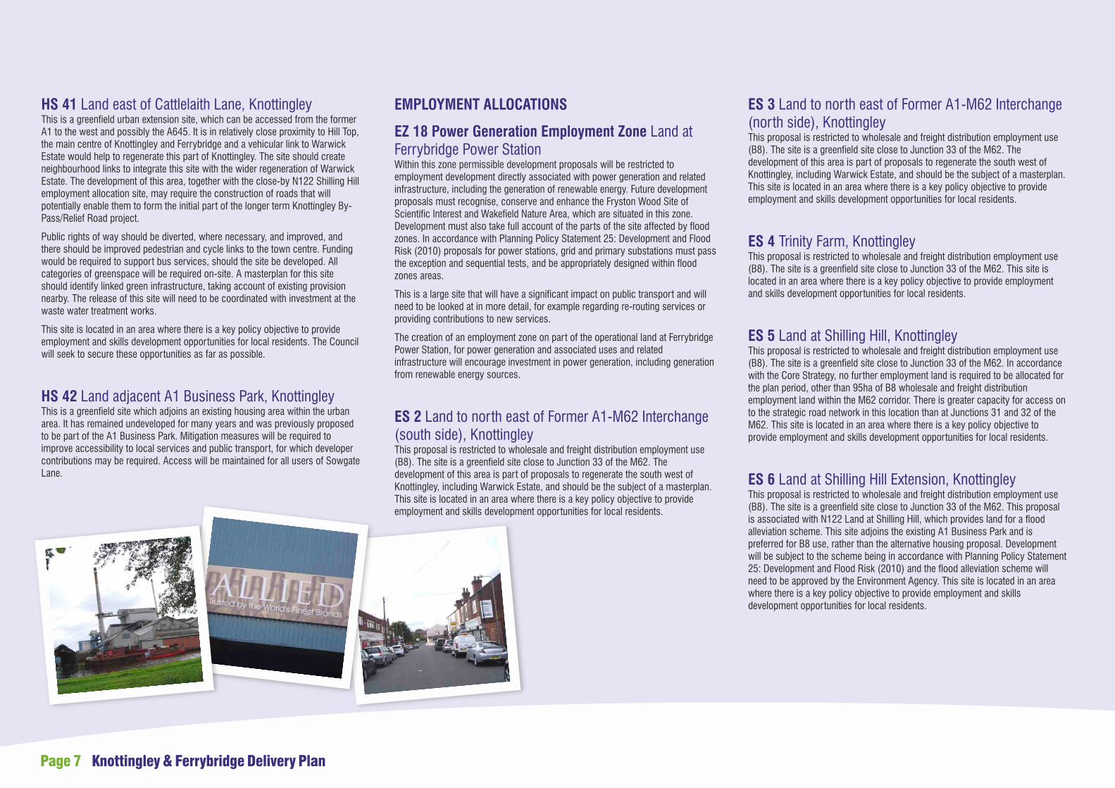
EMPLOYMENT ALLOCATIONS
EZ 18 Power Generation Employment Zone Land at Ferrybridge Power StationWithin this zone permissible development proposals will be restricted to employment development directly associated with power generation and related infrastructure, including the generation of renewable energy. Future development proposals must recognise, conserve and enhance the Fryston Wood Site of Scientific Interest and Wakefield Nature Area, which are situated in this zone. Development must also take full account of the parts of the site affected by flood zones. In accordance with Planning Policy Statement 25: Development and Flood Risk (2010) proposals for power stations, grid and primary substations must pass the exception and sequential tests, and be appropriately designed within flood zones areas.
This is a large site that will have a significant impact on public transport and will need to be looked at in more detail, for example regarding re-routing services or providing contributions to new services.
The creation of an employment zone on part of the operational land at Ferrybridge Power Station, for power generation and associated uses and related infrastructure will encourage investment in power generation, including generation from renewable energy sources.
ES 2 Land to north east of Former A1-M62 Interchange (south side), KnottingleyThis proposal is restricted to wholesale and freight distribution employment use (B8). The site is a greenfield site close to Junction 33 of the M62. The development of this area is part of proposals to regenerate the south west of Knottingley, including Warwick Estate, and should be the subject of a masterplan. This site is located in an area where there is a key policy objective to provide employment and skills development opportunities for local residents.
HS 41 Land east of Cattlelaith Lane, KnottingleyThis is a greenfield urban extension site, which can be accessed from the former A1 to the west and possibly the A645. It is in relatively close proximity to Hill Top, the main centre of Knottingley and Ferrybridge and a vehicular link to Warwick Estate would help to regenerate this part of Knottingley. The site should create neighbourhood links to integrate this site with the wider regeneration of Warwick Estate. The development of this area, together with the close-by N122 Shilling Hill employment allocation site, may require the construction of roads that will potentially enable them to form the initial part of the longer term Knottingley By-Pass/Relief Road project.
Public rights of way should be diverted, where necessary, and improved, and there should be improved pedestrian and cycle links to the town centre. Funding would be required to support bus services, should the site be developed. All categories of greenspace will be required on-site. A masterplan for this site should identify linked green infrastructure, taking account of existing provision nearby. The release of this site will need to be coordinated with investment at the waste water treatment works.
This site is located in an area where there is a key policy objective to provide employment and skills development opportunities for local residents. The Council will seek to secure these opportunities as far as possible.
HS 42 Land adjacent A1 Business Park, KnottingleyThis is a greenfield site which adjoins an existing housing area within the urban area. It has remained undeveloped for many years and was previously proposed to be part of the A1 Business Park. Mitigation measures will be required to improve accessibility to local services and public transport, for which developer contributions may be required. Access will be maintained for all users of Sowgate Lane.
ES 3 Land to north east of Former A1-M62 Interchange (north side), KnottingleyThis proposal is restricted to wholesale and freight distribution employment use (B8). The site is a greenfield site close to Junction 33 of the M62. The development of this area is part of proposals to regenerate the south west of Knottingley, including Warwick Estate, and should be the subject of a masterplan. This site is located in an area where there is a key policy objective to provide employment and skills development opportunities for local residents.
ES 4 Trinity Farm, KnottingleyThis proposal is restricted to wholesale and freight distribution employment use (B8). The site is a greenfield site close to Junction 33 of the M62. This site is located in an area where there is a key policy objective to provide employment and skills development opportunities for local residents.
ES 5 Land at Shilling Hill, KnottingleyThis proposal is restricted to wholesale and freight distribution employment use (B8). The site is a greenfield site close to Junction 33 of the M62. In accordance with the Core Strategy, no further employment land is required to be allocated for the plan period, other than 95ha of B8 wholesale and freight distribution employment land within the M62 corridor. There is greater capacity for access on to the strategic road network in this location than at Junctions 31 and 32 of the M62. This site is located in an area where there is a key policy objective to provide employment and skills development opportunities for local residents.
ES 6 Land at Shilling Hill Extension, KnottingleyThis proposal is restricted to wholesale and freight distribution employment use (B8). The site is a greenfield site close to Junction 33 of the M62. This proposal is associated with N122 Land at Shilling Hill, which provides land for a flood alleviation scheme. This site adjoins the existing A1 Business Park and is preferred for B8 use, rather than the alternative housing proposal. Development will be subject to the scheme being in accordance with Planning Policy Statement 25: Development and Flood Risk (2010) and the flood alleviation scheme will need to be approved by the Environment Agency. This site is located in an area where there is a key policy objective to provide employment and skills development opportunities for local residents.
Page 7 Knottingley & Ferrybridge Delivery Plan

Similar factors are evident in the energy sector with the power station at Ferrybridge providing a source of well-paid employment but with rather limited prospects in terms of significant job creation potential. Furthermore the coal-fired power station is near to the end of its lifetime as a result of UK and European Union carbon reduction targets. Thus despite the development of a new multi-fuel power plant at Ferrybridge, once the employment impacts of the construction phase are over there will be a relatively small long-term job creation outcome. Additional electricity capacity via the building of a gas-powered generation plant on the former Oxiris site will again contribute significantly to temporary job creation effects via its construction phase as its long term operation will require approximately 35 persons to run it.
The structural economic legacy of large, dominant employers has been in essence to "crowd out" other economic activity in the area. Knottingley and Ferrybridge are typified by relatively low levels of self-employment and of business density when compared to the district, Regional or UK levels. The dominance of large employers in Knottingley is contrasted by lower levels of economically active population (70.3% as against 72.1% for Wakefield and 74.0% for Great Britain; latest available data - ONS Census 2001) as well as evidence of higher levels of deprivation.
This picture of a relatively more deprived place with lower enterprise activity is paralleled by structural weaknesses in the supply of office and industrial accommodation that would be suitable for smaller enterprises. Data for property supply and demand over the last five years reveals a picture of comparatively poorer supply and demand.
The clear evidence of structural imbalance and market failure suggests the need for action on:
Supporting the larger enterprises or Key Account Management companies in Knottingley and Ferrybridge to remain competitive;
Creating more supply-side linkages and opportunities between the large enterprises and local SMEs;
Stimulating and supporting the enterprise economy in the locality by assisting more people to go into business or to locate their business there;
Supporting efforts to improve the supply of office and industrial premises that would suit smaller enterprises;
Supporting the anchoring (i.e. the demand side of the equation) of small and medium sized enterprises within the size range of 2-50 employees.
In addition, there may be significant opportunities to develop specific "spin-out" or "supply chain" initiatives around the "waste" products of the large enterprises. For example, the "waste" energy from the multi-fuel plant could be used to attract and anchor businesses or activities that could use the heat or steam from the plant.
The overall priorities for the Wakefield district are set out in the Jobs and Growth Plan (J&GP) for the Wakefield District which was approved by the Council's Cabinet in September 2012, with a focus on Business, Places and People. Whilst Knottingley as a whole is expected to benefit from a number of key district wide programmes included within the J&GP (for example the skills action plan), there are also specific projects identified in the J&GP to promote the delivery of sustainable energy developments and the Wakefield District Transport Strategy (see section 5 A).
SPECIAL POLICY AREA
SPA 8 Oxiris Chemical Works and land adjoining Common Lane, KnottingleyThe prime purpose of this Special Policy Area designation is to assist the reclamation and future beneficial use of the former Oxiris chemical works site, a contaminated brownfield site within the Knottingley urban area. The greenfield urban extension parts of the proposal are regarded as necessary integral parts of the regeneration package. It encompasses a comprehensive package of proposals for the former site and adjoining greenfield land. A combination of housing and an energy centre (power generating uses) incorporating a buffer area of light industrial uses and open space is proposed to regenerate the disused contaminated site. The proposals will also be required to safeguard a route through the site for the possible long term Knottingley By-pass proposal. A major part of the Special Policy Area falls within flood zone 3a. The proposals have been subject to the sequential and exception tests. There should be a minimum 30m stand off from the canal which should be planted to enhance the corridor. Development proposals will need to take account of the prospect of deep mine workings. Development proposals must take full account of the Wildlife Habitat Network status of the northern part of the area. This site is located in an area where there is a key policy objective to provide employment and skills development opportunities for local residents.
Economic regeneration
The LDF Site Specific Policies Local Plan recognises the economic growth potential of the Knottingley and Ferrybridge area with new employment site and zone allocations of over 50 hectares.
The existing Knottingley economy is dominated by large employers notably in the glass packaging and the energy production sectors. However, in terms of economic structure most of these businesses are in mature sectors with typically minimal prospects of significant job growth. Notwithstanding this, they are major employers and spenders within the local economy and there is a continuing need to support and strengthen their impact within the district.
Glass packaging is a sector typified by long established and mature enterprises where competition is concentrated amongst a small number of large companies. Whilst there has been significant capital investment by the glass businesses in Knottingley over the past decade this has not resulted in major employment growth. Indeed, over the past decade competition and energy costs have contributed to reductions in job numbers in the sector. Projecting forward over the next ten years most employment opportunities in the sector will come as the result of replacement factors as an ageing workforce leaves the enterprise.
Knottingley & Ferrybridge Delivery Plan Page 8
Office Supply & Demand (Five Towns inc. Knottingley) Industrial Supply & Demand (Five Towns inc. Knottingley)

The former Knottingley High School (now De Lacy Academy) is eligible for Capital funding to improve outcomes for young people Not in Education Employment or Training (NEET). The Academy has submitted a bid to the Council for this funding to provide construction skills training and this is under review. De Lacy Academy currently has 49% surplus places which are expected to decrease marginally year upon year, reaching 31% surplus places by 2022/23.
The Council is working with the North East Learning Community (NELC), which incorporates Knottingley, to ensure the provision that is available in the area meets young people's needs so that in the future they can contribute to emerging economic demands.
A limited level of Adult Education services is provided from the Adventure Playground on Warwick estate commencing from September 2012.
Transport
The LDF Core Strategy notes that the rail network of local services radiating from Leeds is already running at or close to capacity. In order to provide increased capacity, there is a need for investment in infrastructure to increase capacity at Leeds Station and for the deployment of additional rolling stock to boost frequency - notably on the Knottingley - Castleford - Leeds service. Network Rail's Northern Route Utilisation Strategy sets the context for investment and signal upgrades, and turnback facilities are proposed at Knottingley which might help to achieve a more frequent service. Currently there is an hourly service through to Leeds and an hourly service to Wakefield Kirkgate.
Whilst there is no committed funding identified, Railplan 7 sets out the strategy for improving the rail network in West Yorkshire up to 2026 and lists the following planned improvements:
Increase the service frequency to meet the minimum two trains per hour frequency identified by the Yorkshire Rail Network Study, subject to an affordable and value for money solution being identified;
Potential platform extensions on stations on the Pontefract Line to allow operation of longer trains in order to meet crowding targets.
Other improvements that could address the gaps, but are in need of further development and evaluation:
Consideration of tram train technology to provide improved connectivity to development areas in the 'Five Towns' area of Wakefield District;
Provide improved access to platforms through the installation of ramps at Knottingley Station;
Provide additional car parking by extending the existing car park at Knottingley Station.
Housing
The LDF Core Strategy sets out the locations where most new housing development will occur in the district. This is focused on the three largest settlements as the priority, Wakefield (as Sub Regional City), Castleford and Pontefract (Principal Towns), all of which have close links with the Leeds housing market. Knottingley, alongside Normanton and Featherstone in the Five Towns, is classed as an urban area and next in the settlement hierarchy. New development in Knottingley should help to create a more coherent urban form which better serves the needs of the communities and support regeneration. Housing in local service centres will aim to meet local needs and help to create balanced, sustainable communities as the quality and range of housing available in an area is an important consideration in attracting skilled labour.
To support this activity the evidence base of housing need throughout the district is identified in the Strategic Housing Market Assessment 2011 and the Strategic Housing Land Availability Assessment 2012. On-going activity will continue to deliver the 2011-15 affordable housing programme in partnership with Registered Providers, agents and the Homes and Communities Agency to identify and bring forward suitable sites.
The LDF Site Specific Policies Local Plan allocates the following new housing sites - land at A1 Business Park, land west of Jackson’s Bridge, the former A1-M62 Interchange and Wormersley Road, with potential to deliver over 1200 new homes.
Education
The Knottingley pyramid of schools comprises five primary and one secondary school. The secondary school does not have a sixth form.
Currently, there are sufficient school places across the pyramid, however some year groups in the primary schools are full and there are limited reception places available. The secondary school has available school places. By September 2013 pupil place forecasting indicates there will be a shortage of reception places across the pyramid which increases further in 2015, this is partly due to the rising birth rate. It is forecast that the pupil yield from developments identified in the LDF Sites Specific Policies Local Plan will compound the shortage of reception places across the pyramid and lead to a shortage in other year groups in some of the primary schools. As a result developer contributions towards the provision of school places and childcare provision will be required.
The level of Capital funding the Council receives is now substantially reduced but the Primary Capital Programme, before it was discontinued, has provided capital investment in the locality. It is funding the expansion and refurbishment of the buildings on the old Ferrybridge Infant School site, to provide improved educational facilities for the amalgamation of Ferrybridge Infant School and Roundhill Junior School.
Page 9 Knottingley & Ferrybridge Delivery Plan
The Site Specific Policies Local Plan notes the potential in the long term for a Knottingley by-pass / relief road proposal to the south of the town and the possibility of the former A1-M62 Interchange housing allocation site and the Oxiris Special Policy Area to protect a route to deliver a phase of the bypass in the future as required.
There are regular bus services connecting Ferrybridge and Knottingley with Wakefield, Pontefract and Featherstone and less frequent services to Castleford, Normanton and Doncaster. However the majority of services do not continue into the evening thereby hindering opportunities to help people access employment and training opportunities.
Statutory Air Quality Management Areas (AQMAs) have been declared in Knottingley and the M62 associated with traffic on the M62 and A645. The Council has a duty to investigate mitigation measures that are available "in pursuit of the objectives". This will require a commitment by all stakeholders that could influence the level of traffic on the AQMAs to ensure that European and National air quality limits and objectives are met.

Health and Green Infrastructure
A range of indicators suggest a significant proportion of the district's population have health problems. More than 20% of people in the district have reported in surveys that they have a limiting long-term illness, health problem or disability. On average people living in areas to the east of Wakefield city experience significantly higher levels of poor health compared to those living in the west of the district. Of particular concern is the need for more services to be provided locally and to be more integrated and Knottingley is one of the most deprived wards in the district in terms of health. Wakefield Council's Public Health unit is supporting Change4Life, a nationwide movement designed to help people make changes to their lifestyles, so that they can eat well, move more and live longer.
The Council's Green Infrastructure Plan and draft Greenspace Strategy 2 recognise that the returns from investing in green infrastructure can be calculated in economic, social and environmental terms. Those investing to derive economic returns will look to green infrastructure to lower environmental risks through flood risk mitigation for example. Those investing to secure social returns will expect green infrastructure to improve the health and well-being of local communities. Those investing to deliver environmental returns will want green infrastructure to improve local biodiversity, air and water quality. The key drivers for green infrastructure investment are sustainable economic growth and regeneration, climate change, health and well-being, and biodiversity which are translated in the Green Infrastructure Plan as Strategic Objectives. Knottingley and Ferrybridge are seen as areas of opportunity within the Plan.
As highlighted in the LDF Development Policies Document (policy D5 - Ecological Protection of Watercourses and Water Bodies) weirs can act as significant barriers to the passage of migratory fish and other wildlife such as otters. The LDF recommends that 'where possible opportunities to remove weirs or install fish passes should be taken, especially on the River Aire and River Calder'. The weir adjacent to ADM Milling on the River Aire in Knottingley currently hinders the ability of salmon and sea trout to migrate to spawning grounds further upstream. The Environment Agency is currently exploring ways to install a fish pass along this section of the river Aire.
A significant area of Knottingley lies within Flood Zones 2, 3a and 3b. As such, flood risk assessments will be required for planning applications which fall within these zones.
With the benefits of the river and canal system within Knottingley, Ferrybridge and Greenhouse Parks, and Kellingley Welfare sports and leisure facility in close proximity, access to public open space and the countryside is fairly well provided. However the quality and current use of these areas is an issue and the quality of the town's public realm is also poor in many areas and in need of revitalisation. The Council's Rights of Way Improvement Plan currently promotes a health walk from Ferrybridge Health Centre together with a health walk leaflet, and Knottingley's proximity to the river and canal should provide enhanced opportunities for healthy lifestyles as development progresses. Sustrans have also identified a number of improvements to the cycle route network which could be undertaken if funding is identified.
The LDF Core Strategy also promotes the delivery of good quality, well maintained leisure, recreation and open space facilities to meet the needs of local communities, particularly deprived groups, identifying the need for increased and improved facilities for health and fitness at Knottingley Sports Centre and pool. The Council and the Physical Activity, Sport and Health partnership (PASHP) is currently mapping out a vision for the development of sport and physical activity across Wakefield District over the next 5 years.
Heritage
Knottingley is situated on top of a limestone ridge and is well known for its vast limestone quarries, some of which are still in existence today. Limestone is very evident locally in the form of limestone boundary walls. Sadly many of these have been demolished in recent years. Whilst the walls are not designated, other than controls on demolition through the conservation area designation, it is hoped that through the regeneration process the importance of these walls to the identity and heritage of the Knottingley area can be amplified.
© Crown copyright and database rights 2013Ordnance Survey 100019574
Knottingley & Ferrybridge Delivery Plan Page 10
© Crown copyright and database rights 2013Ordnance Survey 100019574
Knottingley, Air Quality Monitoring Area (AQMA)
Proposed 'Links to Stations Network' improvements, subject to funding

Page 11 Knottingley & Ferrybridge Delivery Plan
It should be noted that many of the projects detailed below are interlinked.
A. Employment, Business and Skills
The J&GP seeks to promote and assist the delivery of sustainable energy developments, adaptations to climate change and the development of the green economy. To meet this objective the J&GP promotes the delivery of two new major projects led by the private sector - a multifuel energy power plant at Ferrybridge C and proposed gas fired power station on the former Oxiris chemical works in Knottingley.
A1. Multifuel energy power plant at Ferrybridge C (J&GP priority C6)Scottish and Southern (SSE) has a 50:50 joint venture known as Multifuel Energy Ltd with US firm Wheelabrator Technologies Inc. to develop a new £300m 68MW power plant. The plant will use processed waste as part of its fuel input. Construction of the plant will be undertaken by Hitachi Zosen Inova (HZI), with the John SISK Group undertaking the site construction works. 300 jobs will be created during the three-year construction period and over 50 new full time jobs will be required once the plant is fully operational. There are also considerable procurement opportunities (approximately £50M+) for local companies as a result of the building of the multi-fuel plant.
Timetable: 2012/13 - Site cleared, procure contractors and supply chain. March 13 - Commence construction on-site. Expected completion - early 2015.
A2. Reclamation of the former Oxiris chemical works, KnottingleyThe former chemical works site is owned by St Paul's Developments who have submitted a bid for Growing Places Funding to commence reclamation and highways infrastructure works on the site. These works will run in parallel to the statutory approvals process for the gas-fired power station (A3 below) which, if the power station approvals are successful, will ensure that the site is ready for construction without any undue delays.
The draft masterplan for the Oxiris site proposes a level of housing and employment development adjacent to the power station, together with improved linkages to the Aire and Calder Navigation and potential for leisure development.
Timetable: 2012 - Submit Planning Application.2013 - Commence reclamation and highways infrastructure works. 2015 - construction of gas fired power station commences.
A5. Business Support SchemeThe socio-economic profile for Knottingley identifies significant employment deprivation in the area, a reliance on a small number of large employers and low levels of self employment. In order to encourage entrepreneurship as part of a district wide initiative, the Council will aim to secure external funding to provide a comprehensive package of support for start-up and young businesses.
Timetable: September 2012 - submit outline business case for ERDF funding to support initiative. November 2012 - submit full business case for ERDF funding. April 2013 - commence delivery (subject to securing external funding).
A6. Enterprise and Education InternshipsTo encourage entrepreneurship amongst young people and to provide opportunities for work related experience, a district wide programme of internships with local employers will be created, together with enterprise clubs, Young First Friday events, and a programme of enterprise activity within schools.
Timetable: Business Week - March 2013, Internships - from Summer 2013, subject to ERDF funding.
5. Delivery Programme 2012 -2015A3. Gas fired power station, Knottingley (J&GP priority C6)Knottingley Power are proposing to build a new 1,500MW gas-fired power station on the former Oxiris site providing over £750m of investment into the area, 1,100 jobs at the height of construction and 50 permanent jobs. The power station will generate enough electricity to power around 2 million homes and by using natural gas as the fuel, will produce less carbon dioxide than most other types of fossil fuel powered stations.
Timetable: 2012-14 - Commence public consultation process; pursue statutory approvals (submit application to Planning Inspectorate Spring 2013). 2015 - Commence construction, subject to approval from HM Government. 2018 - Commence operation.
A4. Wakefield Enterprise Partnership (WEP) Skills and Employment Partnership To ensure that the local workforce have opportunity to benefit from these major employment initiatives, during construction and post-construction phases, links will be forged between the WEP Skills and Employment Partnership and the employers/developers from an early stage of development. SSE and their sub contractors (Hitachi Zosen and Sisk) have already agreed to work through the Skills and Employment Partnership as a conduit to provide a bespoke recruitment service for temporary employment opportunities during the development of the new site and permanent posts for the new site above and beyond any transfers from the current workforce. Knottingley Power has also made a commitment to work with the WEP.
The Economic Growth and Housing Service will continue to work in partnership with landholders, partners and developers in the Knottingley area to bring forward new investment and employment initiatives throughout the Delivery Plan period for the benefit of the wider regeneration programme in accordance with the Local Development plan.
Timetable: 2012-15 - on-going dialogue and partnership working with key employers, investors and training providers to provide targeted skills and a workforce ready to participate in employment growth opportunities. Knottingley Work Club - on-going, weekly, at Knottingley Library.

B. Transportation and Highways
The J&GP identifies the importance of delivering the Wakefield District Transport Strategy and Implementation Plan (2011-2026) to support the achievement of economic development, employment and low carbon goals. To meet this objective the annual action plan of the J&GP highlights two specific projects to aid delivery - the Dish Hill RGF2 Programme and developing opportunities for better transport to connect people living on Warwick estate to employment.
B1. Ferrybridge Dish Hill Infrastructure Project (J&GP priority C7)The £1.6m Regional Growth Fund and S106 funding secured to construct the Dish Hill roundabout will ease congestion, enable the diversion of heavy goods vehicle traffic from Ferrybridge centre and aide the continued development of the Ferrybridge power plant site and related plaster board facility.
The project also secures a future location for employment and investment in the energy sector, opening up 40 hectares of employment land and investment into the multi fuel power station. In addition the project will deliver £200k of environmental improvements in Ferrybridge Square.
Timetable: Procure construction works - 2012/13. Commence and complete construction - December 2013.
B2. Warwick Estate - Connecting people to employment (J&GP priority C7)The current low level of public transport provision connecting the estate to the rail station and local and regional employers has been identified as a restrictor to residents accessing employment opportunities and skills training. Transport is therefore identified as priority within the Warwick Ahead Community Plan (see C1 below), with a community bus initiative being considered as a potential pilot scheme. Warwick Ahead is a community led initiative funded through the Big Lottery and supported by local agencies.
Timetable: Review transport opportunities available to residents to provide access to employment opportunities - by end 2013.
B3. Review of transport infrastructure improvements and funding mechanismsAs part of previous consultation events residents have highlighted concerns regarding transport infrastructure, traffic congestion and a perceived high number of HGVs running through the town on the A645. The Council will therefore review the current infrastructure provision with other providers and implement early wins where funding has been identified in order to improve transport links to and from Knottingley, highway safety enhancements, and enhance the pedestrian and cycle experience of the town to reduce dominance of the car, e.g.:
Sustrans have identified a number of improvements to the cycle route network which could be undertaken if funding is identified;
The Council's Rights of Way Action Plan identifies opportunities to develop and promote the waterside routes; potential links into North Yorkshire; formalisation of paths at Ferrybridge towards Fryston Wood; and opportunities to interpret the heritage of the area, promoting walking, cycling and horse riding routes;
Opportunities to improve transport connectivity through the Local Transport Plan (short-term) and West Yorkshire Transport Fund (long-term).
Timetable: Review transport infrastructure requirements and opportunities for developer contributions - July 2013. Implement early wins - March 2014.
Community Infrastructure Levy Local Plan - Publication of submission document/formal consultation - July 2013; Adoption by Council - approx. April 2014, subject to consultation, examination in public and Inspector's report.
B4. Low Emission Strategy (LES)The Council, together with other local authorities in West Yorkshire, is developing a Low Emission Strategy which will lead to an implementation plan to mitigate against any negative transport emissions impact arising from development and identify through evidence based methodologies, the most effective low emission strategies to be implemented within individual authorities in West Yorkshire.
Timetable: Commence LES - Dec 2012. Complete LES - June 2014.
© Crown copyright and database rights 2013 Ordnance Survey 100019574
FerrybridgeDish Hill Infrastructure Project
Existing HGV Route
Current and ProposedEmployment Boundary
Proposed MultiFuel Plant
LafargePlasterboardPlant
FerrybridgeBusiness
Park
A162
Existing Roundabout(Brotherton Ings)
B6136
B6136
A1
Entrance/Exit
Ferrybridge
Proposed Roundabout(Dish Hill)
Ferrybridge Project Map

Page 13 Knottingley & Ferrybridge Delivery Plan
D. Town Centre Environment and Public Realm
D1. Retail and Town Centres Local PlanDevelopment of a Local Plan document which will cover retail at most levels of the retail hierarchy - from Wakefield City Centre, town centres, local service centres to parades of shops on estates - and identify existing provision and future need and demand across the district.
Timetable: Publication of submission document/formal consultation - June-July 2014; Adoption by Council - approx. May 2016, subject to consultation, examination in public and Inspector's report.
D2. Environmental improvement scheme - Ferrybridge (linked to B1 above)Funded through Regional Growth Fund 2, £200k of environmental improvements will be delivered in Ferrybridge Square, including introduction of a 20mph zone, HGV restrictions, new paving, signage and highway improvements.
Timetable: Initial design work - autumn 2012. Consultation - January 2013. Construction - Summer 2013.
D3. Character Zone - Hill Top - Central Amenity AreaOne of the priorities emerging from the LDF and public consultation is the establishment of a recognised retail centre within Knottingley as provision is dispersed and connections limited. The development of the Morrison's store on Hill Top in 2004 has brought some level of prominence to the area and together with the clustering of facilities including the Arcade shopping precinct, the public library, sports centre, local pubs and Kellingley Miners Welfare, employment uses, and good access to the rail station, this area offers a good opportunity to make Hill Top a focus of activity for the town.
Utilising an existing Memorandum of Understanding between the Council and Leeds Metropolitan University (LMU), urban design support will be provided to develop a detailed action plan for the first of the Knottingley and Ferrybridge Delivery Plan 'character zones' - Hill Top. The action plan will identify small, medium and longer term initiatives to promote this central amenity area as the town centre of the Knottingley area and improve connections to the surrounding neighbourhoods.
Timetable: Commission LMU - December 2012. Draft action plan for consultation - March 2013. Initiate town centre specific projects - Spring 2013.
C. Community - The Importance of Social Development and Community Safety
C1. Warwick AheadWarwick Estate was one of the first 50 areas to be chosen for Big Local Trust funding, funded through the Big Lottery. The Big Local Trust has pledged to invest £1 million into the estate over 10 years (2011-2021). 'Getting People Involved Round 1 and 2' has been led by One to One Development Trust and includes two partner organisations The Old Quarry Adventure Playground and Warwick Community Group. Big Local has invested £30,000 to support these stages which is in addition to the £1m core funding. Warwick Ahead has completed work on the estate profile which forms the basis for their future Vision. Earlier in 2012 the group established partnership arrangements in the form of a Board. A requirement of the partnership arrangements is that 51% of the Board must be residents.
Warwick Ahead are currently developing a Community Plan for their area and launching a series of interest groups to focus on key themes of interest and concern to make the estate a better place to live. These include: Poverty and Wealth, Community Wellbeing, Children and Young People, Transport, Environment and Safety. The Community Plan will outline the priorities for the Big Local money over the next 18 months to 3 years.
Timetable: Complete community profile - 2012. Initiate sub groups - September 2012. Launch Community Plan - December 2013.
C2. Knottingley Community PartnershipPontefract and Knottingley Neighbourhood Police Team (NPT) launched the Community Partnership initiative in March 2011 in order to to reduce crime and disorder in the locality. The group has identified a number of initiatives, subject to funding being secured, including:
Improved lighting and décor at Ferrybridge subway;
Installation of CCTV across Knottingley and Ferrybridge;
A youth 'pod' and ball court at De Lacey Academy.
Timetable: Ferrybridge improvements - 2013/14, subject to funding.De Lacey play facility - 2013/14, subject to funding.
D4. Environmental improvement scheme - Hill Top (linked to D3 above)Development of a public realm scheme for the Hill Top retail area including potential for new signage, replacement of safety barriers, 'welcome to Knottingley' signs, and greenery, to improve connectivity to local areas, improving the environment for pedestrians and cyclists where possible and including better waymarking to the river, canal and footpaths. Engagement with local business and property owners to work in partnership to bring forward improvements in the Arcade area.
Timetable: Installation of two Victorian style benches outside the Town Hall - summer 2012. Public realm scheme initiatives - 2013-2014.
D5. The Close, Hill TopPrivate sector led retail development consisting of one A1 Foodstore unit and four units for a mix of uses including A1 (Shops), A2 (Financial and Professional Services) and A3 (Restaurants and Cafes).
Timetable: Submit planning application - summer 2012. Planning Determination - early 2013. Commence demolition and redevelopment: 2013/14 - subject to securing foodstore operator and planning consent.
D6. Co-location of library facilities with Knottingley Sports Centre (linked to D5 above)Development of a library hub model of service provision to provide a better social environment (through changes in service policy and practices), a wider range of lending stock (books and audio-visual) and a much wider range of activities and events delivered by staff and volunteers that meet the needs of residents in the branch catchment.
Timetable: Relocation from The Close site into Sports Centre - Spring 2013. Launch of improved mobile / Home library service - Summer 2013.
D7. In BloomThe aspiration for the 'greening' of Knottingley has been identified by local people as an early project to support the regeneration of Knottingley, to improve the environment and the overall attractiveness of the Hill Top area. In summer 2012 the Council supported the supply and maintenance of 40 floral displays along the Hilltop corridor in advance of Knottingley Carnival. It is hoped that the introduction of hanging baskets will raise local interest in a potential Knottingley In Bloom initiative in future years which could attract local sponsorship.
Timetable: Initial floral displays in Hill Top (Council led initiative) - June-October 2012. Community-led initiative for floral displays in wider Hill Top area - Spring 2013 onwards.

Raised Plateau
New Paving (Kellen)
20mph Zone (High Street)
Speed Cushions
20
2020
20
20
L
L
L
L
Lorry RestrictionL
© Crown copyright and database rights 2013Ordnance Survey 100019574
WDH's intention is by 2012 to bring the homes they own in the district up to a local standard known as The Wakefield Standard which is a far higher standard than the Decent Homes Standard. In the period of this Delivery Plan this includes an upgrade to properties on Ferrybridge estate and targeted work to 'hard to treat' properties.
WDH will submit a joint bid with the Council to the Department of Energy and Climate Change (DECC) for a district wide programme targeting both social and private sector housing and fuel poverty.
Timetable: Upgrade to properties on Ferrybridge estate - 2012/13. Submit DECC bid - Dec 2012. Targeted work to 'hard to treat' properties - on-going.
E3. Other land / propertyThe Economic Growth and Housing Service will continue to work in partnership with landholders, partners and developers in the Knottingley area to bring forward improvements and development for the benefit of the wider regeneration programme in accordance with the Local Development plan. In addition, the Regeneration team will continue to provide consultation comments on significant planning applications within the area to ensure that new development proposals continue to support and enhance the regeneration work in Knottingley and Ferrybridge.
Timetable: On-going
D8 Environmental improvement scheme - Racca GreenSubmission of a 'cycle hot spot' bid to the Department of Transport as part of accident prevention measures - £150k to improve the traffic signals, provide cycle lanes and advanced stop lines around the Racca Green junction. Public realm initiative focussed on the Racca Green parade of shops.
Timetable: DfT bid submission - August 2012. Public realm scheme initiative - 2014, subject to funding.
E. Housing
E1. Yorkshire Housing Development of 18 affordable homes at Hazel Road former health centre/fire station and 10 at the former Wallbottle public house, Warwick estate. Half of the properties will be for social rent and half for 80% of market rent.
Timetable: Submit planning application - May/June 2012. Start on site - November 2012. Completion - autumn 2013.
E2. Wakefield and District Housing (WDH)The new build programme WDH commenced with in late 2005 has had a direct impact on Knottingley with 123 properties having been developed on the Wentcliffe estate in Ferrybridge, with a further 27 having been developed just off the centre on Fisher Street.
Ferrybridge Square improvements
Knottingley & Ferrybridge Delivery Plan Page 14

Page 15 Knottingley & Ferrybridge Delivery Plan
F2. (Sport) Greenhouse Park / The CloseIn October 2010, as part of the Cabinet approval to dispose of Council land at Hill Top, it was agreed that an element of the capital receipt is utilised to improve the quality of local park and sports facilities and facilitate wider regeneration objectives. A section of Greenhouse Park may therefore be improved to facilitate a kickabout area and it is proposed that other funding is used initially to pump prime a bid to improve the changing facilities adjacent to the sports pitches.
Timetable: Complete works to new kickabout area; Submission of funding bids for changing facilities (by Kellingley Miners Welfare) identify alternativelocations - subject to timing of D5 above.
F3. (Open Space / Community) Aire and Calder Navigation and Enhancements to Rights of WayTo emphasise the role the waterways can play in the regeneration of Knottingley, and to encourage access and enjoyment of the waterways for local people, opportunities to be pursued with the Canal and Rivers Trust, the local community and other partners for the development and enhancement of the Aire and Calder Navigation to maximise the benefit for local people and new visitors to the area. Potential projects include: clearing the former quarry area with the development of a community and sensory garden; developing activities and educational programme, e.g. bird box making, willow weaving, promotion of healthy lifestyles; potential to become part of a district wide sculpture trail, including interpretation boards or Quick Response codes which can be scanned by most Smart phones, improved signage, promotional activity.
2012 saw the first charity Dragon Boat festival in Knottingley on the Aire and Calder Navigation. Organised by the Rotary Club of Osgoldcross and Elmet, the event proved a successful way to engage the community with the waterway in a fun environment, whilst raising money for good causes. It is hoped that this will become an annual attraction and draw visitors to the area.
Timetable: Dragon Boat festival - annual, spring bank holiday. Fruit treeplanting - November 2012. Community consultation to inform next steps - February 2013. Development of Fish Pass - subject to funding.
F. Sport/Culture, incl. Community Facilities and Open Space
The Council and the Physical Activity, Sport and Health Partnership (PASHP) are currently developing 'The Physical Activity and Sport Strategy' which will outline the priorities for sport and physical activity for the district. The Council also has an approved Playing Pitch Strategy 2011 - 2030, which is an assessment of supply and demand for key pitch sports across the district, adopts a prioritised process of site identification to guide investment, ensuring that local regeneration is targeted at the right types of provision in the right areas. In addition, the forthcoming Leisure, Recreation and Open Space Local Plan will allocate sites for community facilities for leisure and recreational purposes.
It is recognised that due to the age and deteriorating condition of Knottingley Sports Centre, it is no longer fit for purpose. The centre has however proved increasingly popular as a result of a number of minor investments in recent months, demonstrating a clear need for improved sports facilities in the locality. It is recommended that this is developed alongside the strategies and development plan document highlighted above but should also consider any proposed rationalisation of sports facilities beyond the boundaries of Knottingley, in particular swimming pool provision in the east of the district.
F1. (Open Space/Sport) Ferrybridge ParkSubmission of Inspired Facilities bid to Sport England to help improve the football and bowling facilities at Ferrybridge Park. If successful, the project will replace a dilapidated 2-team changing room and tired bowling pavilion with a new purpose-built facility providing 4-team changing rooms; toilets; kitchenette and social area. It will create an additional senior football pitch with ball-stop fencing and provide much-needed car parking for users and visitors. The aim of the project is to increase and develop sport participation by making these essential improvements to this valued local facility, to be used by the whole community as well as new and current members. £150k is being requested from Sport England, to be matched by £459k from Wakefield Council.
Timetable: Submission of Inspired Facilities bid - September 2012
F4. (Open Space) - Local play area enhancementsAn audit of the distribution and quality of significant green space and play areas has recently been completed by the Council as part of the updating of the Greenspace Strategy. The Pottery Lane / North View play area is a S106 funded development which incorporates linkages to the riverside. The existing open space at the end of Hazel Road is to be upgraded in partnership with the local community and police. The Marsh Lane (Howard's Field) sports clubs have indicated an interest in refurbishing and leasing the changing rooms.
Timetable: Pottery Lane - March 2013. Hazel Road - Phase 1 completion summer 2012; Phase 2 following further engagement. Marsh Lane - Summer 2013.
F5. Leisure, Recreation and Open Space Local PlanLDF Local Plan to allocate sites for community facilities for leisure and recreational purposes across the district.
Timetable: Publication of submission document/formal consultation - June/July 2014; Adoption by Council - approx. May 2016, subject to consultation, examination in public and Inspector's report.
F6. Knottingley Fish PassFeasibility work to review options for a fish pass adjacent the Knottingley weir on the River Aire to improve the ability of salmon and sea trout to migrate to spawning grounds further upstream.
Timetable: Project Board established - March 2013. Feasibility Study completed - October 2013. Funding Bids submitted - March 2014.

Knottingley & Ferrybridge Delivery Plan Page 16
European Regional Development Fund (ERDF) 2007-2013 in England is managed by central government. This fund is focused on supporting economic regeneration and safeguarding jobs. Funding priorities are:
Priority 1 - Promoting Innovation and Research and Development
Priority 2 - Supporting and Stimulating Successful Enterprise
Priority 3 - Sustainable communities
A bid for ERDF funding to provide a business support package for start up businesses has been submitted by the Council in 2012.
The Homes and Communities Agency oversees budgets for housing and housing-related programmes, including the affordable new homes and Decent Homes programmes, Getting Britain Building initiative and the new FirstBuy affordable home ownership scheme. The main sources of funding for housing interventions will be from the private sector or, in the case of Registered Providers of social housing, contribution from their own reserves or borrowing.
Yorkshire Housing schemes at Hazel Road and the former Wallbottle are part funded through HCA funding.
Wakefield Council's Capital Programme (Regeneration Developments) - Selective funding may be available where this can be shown to 'kick start' regeneration. An initial £50,000 has been identified to support early project realm improvements.
Funding availability in support of regeneration activities has reduced dramatically in recent years across both the public and private sectors meaning that partners need to take a more holistic approach towards funding assembly when planning developments.
Partnership working between the Public, Private and Third Sector is becoming increasingly important in the retention of existing (and attraction of new resources) to support regeneration initiatives.
Private Sector investment will be key to unlocking the economic growth and future prosperity of the Knottingley and Ferrybridge regeneration area given the reduction in public sector funding availability and an environment needs to be created that positively encourages and supports private sector development and investment in the area.
Notwithstanding the need for private sector investment, potential sources of public funding which may be accessible to support this delivery plan include:
Regional Growth Fund (RGF) is a £2.4 billion central government fund operating across England from 2011 to 2015. It supports projects and programmes with significant potential for economic growth that can create additional, sustainable private sector employment. It aims particularly to help those areas and communities which were dependent on the public sector to make the transition to sustainable private sector-led growth and prosperity.
Funding is successfully secured for Knottingley as part of RGF Round 2 in order to deliver the Dish Hill roundabout scheme to assist the expansion of Ferrybridge power station. RGF Round 3 completed in October 2012 and information on a possible Round 4 is awaited.
Growing Places Fund (GPF) is administered by the Leeds City Region Local Enterprise Partnership (LEP) and is aimed at increasing employment and economic growth, and decreasing carbon emissions across the region. The GPF provides loans of between £250,000 and £5 million and supports capital investment in infrastructure, which covers a wide range of projects such as expansion of business premises to the development of new road junctions. Applications from small and medium-sized enterprises are particularly welcome.
Round 2 closes in December 2012 and information on a possible Round 3 is awaited. The Council is working with St Pauls Developments to secure GPF to initiate remediation and infrastructure works on the former Oxiris chemical site.
6. Funding
Section 106 funding - Whilst planning decisions cannot be prejudged there is potential for S106 planning obligations to contribute towards initiatives in the area, which may include the following:
- Highway and public transport improvements
- Open Space requirements
- Affordable housing
- Education contributions
In addition the Council will prepare a Community Infrastructure Levy local development document which will provide a charging schedule setting out a financial levy to be applied to new development to support the delivery of essential infrastructure across the district. Such a levy would be limited to the most appropriate level of resources required to support infrastructure development whilst continuing to attract private sector interest in developing out the area.
Lottery funding is available to support a number of different types of initiatives, including sport, art, heritage and community based activity.
Warwick Estate is one of the first 50 areas to be chosen for Big Local Trust funding, funded through the Big Lottery. The Big Local Trust has pledged to invest £1 million into the estate over 10 years (2011-2021).
Private Sector investment will be key to unlocking the economic growth and future prosperity of the Knottingley regeneration area.
This list is not intended to be exhaustive as many smaller funding providers and initiatives exist and may be accessible to support the draft initiatives. Similarly, this list is not intended to be a guarantee of availability of resources as each initiative 'bid' will likely be subject to increasingly stringent bidding criteria and increasing competition.

Page 17 Knottingley & Ferrybridge Delivery Plan
Knottingley Officer Group - Terms of Reference
The role of Knottingley Officer Group is to:
1. Ensure the effective, efficient and timely delivery of regeneration in Knottingley and Ferrybridge.
2. To co-ordinate the activities of the various Council Services insofar as it relates to Knottingley, and where possible, those of partner bodies.
3. Support individual projects and initiatives in a pro-active way.
4. Consider the implications of proposed actions of key stakeholders affecting Knottingley and Ferrybridge regeneration.
5. Seek to resolve problems or outstanding issues between stakeholders / partners on issues affecting the regeneration of Knottingley and Ferrybridge.
6. Co-ordinate Council activities within, or which have an impact on Knottingley and Ferrybridge and encourage joint working.
7. Deliver, update and amend the Knottingley and Ferrybridge Delivery Plan
8. Provide guidance and direction to individual sub Groups and officers as appropriate.
Membership
Wakefield Council:- Regeneration- Strategic Housing- Economic Development- Sports and Active Lifestyles - Transportation and Highways- Spatial Policy and Development Management- Family Services / Education- Street Scene- Property and Asset Management- Legal Services- Finance
Frequency 6 weekly meetings during preparation of Delivery Plan; thereafter to be reviewed. Project specific meetings will be convened on a more frequent basis as required by the delivery programme.
Reporting The Knottingley Officer Group will report to the Steering Group and Cabinet Members Briefing every quarter. There will be clear accountability via Cabinet and Overview and Scrutiny Committee for key decisions and on-going communication with Ward Councillors.
Overall strategic direction for the project will come from Wakefield Council's Portfolio Holder for Regeneration and Economic Growth and the Knottingley Steering Group. Both will receive update reports on a regular basis, the former via Cabinet Members' Briefing.
An officer level operational group has been established to have an overall view of the regeneration proposals for Knottingley and give officer direction to the initiative. Individual project groups shall co-ordinate the day to day implementation of the scheme. The proposed terms of reference and membership for the Steering Group and Officer Group are described below. A Knottingley specific Communications Plan will also be produced to ensure effective communication with residents, businesses and stakeholders.
These proposals are in line with effective programme and project management and will help ensure the co-ordination and delivery of the Knottingley regeneration initiative and the individual projects within it.
Knottingley Steering Group - Terms of Reference
To facilitate the regeneration of Knottingley a Steering Group has been established to help prepare and oversee the implementation of a comprehensive regeneration programme. The following sets out the proposed management arrangements to deliver this programme.
a Steering Group which will take a strategic view of and give direction to the Knottingley Regeneration Programme,
an officer group (the 'Knottingley Officer Group') which will support the Steering Group, and meet on a regular basis to co-ordinate the day to day development and implementation of the Programme.
Short term technical/ad hoc groups and individual project management groups may be established to deal with specific aspects of the programme but only where the added value of such a group can be demonstrated.
(a) Terms of Reference
The Steering Group shall:
1. Provide overall strategic direction for the regeneration of Knottingley in order to agree the objectives, scope and nature of the regeneration programme.
2. Consider and advise on the development and progress of the regeneration programme for Knottingley, including the development and delivery of the Delivery Plan and individual projects within it.
3. Advise on the priorities for short term actions.
4. Advise on timescales for bringing forward investment.
5. Monitor progress on the major outputs and outcomes.
6. Consider key issues of finance and risk.
7. Encourage partnership and joint working between the key partners.
7. Project Management Arrangements8. Champion the programme and individual projects in a proactive way.
9. Support the Knottingley Officer Group through advice on the resolution of strategic issues.
10. Recommend actions to Wakefield Council and other partners through the appropriate decision making processes.
11. Ensure that appropriate engagement and liaison is undertaken with key stakeholders, including elected Members and the community.
12. Advise and assist in the promotion and publicity of regeneration activity in Knottingley and Ferrybridge.
(b) Membership
Membership of the Steering Group will be:
District Councillor representation for Ward 9
Local Member of Parliament
Wakefield District Housing
Knottingley Town Hall Committee
Ferrybridge Community Centre
Environment Agency
De Lacey Academy
Canal and River Trust
PCT
Circle of Friends Group
Warwick Ahead
Homes and Communities Agency
Groundwork Wakefield
The Steering Group will be chaired by a Local District Council Member
(c) Quorum
The quorum for any meeting of the Steering Group shall be 50% of the membership of the Group in attendance at any meeting.
(d) Frequency
Meetings will be held every three months or as deemed appropriate by the Steering Group.
(e) Reporting
The Steering Group will receive reports from the Knottingley Officer Group and from project managers of the individual projects within Knottingley regeneration programme. Individual reports will include background, current progress, issues, risk and finance.
(f) Administrative Support
The Steering Group will be administered by Wakefield Council's Economic Growth and Housing service.

Knottingley & Ferrybridge Delivery Plan Page 18
8. Action Plan
WHAT HOW WHO(lead partner/s in bold)
WHEN RESOURCESOUTCOME
A1
A2
A3
A4
A5
A6
Multifuel energy power plant at Ferrybridge C
Remediation and redevelopment of former Oxiris site
Gas fired Power Station in Knottingley
WEP Skills and Employment Partnership
Business Support Scheme
Enterprise & Education Internships
Procure contractors and supply chain. Commence construction on-site.
Work with Oxiris to secure cashflow funding & progress remediation / early infrastructure works.
Pursue statutory approvals.
Work with employers to maximise jobs for local people.
Apply for ERDF to support a comprehensive package of support for start-up and young businesses (Part of district wide scheme)
Develop a programme to provide internships with local employers. Create and run enterprise clubs Young First Friday events, programme of enterprise activity within schools. (Part of district-wide scheme)
Private Sector
Private Sector, WMDC
Private Sector
WMDC/Jobcentre+, Private sector
WMDC
WMDC
Mar-13
Mar-14
Mar-15
Mar-15
Mar-15
Mar-15
Creation of 300 construction jobs; 100 plant jobs
Former chemical works remediated to open up housing and employment land.
Planning consent secured. New gas fired power station construction on site (1000+ jobs) & 50 FTE.
A skilled workforce, ready to access employment opportunities
More business, improved GVA, more investment more jobs
More young people connected to work and experience
£350M Private Sector
Growing Places Funding, Private Sector
£750m Private Sector
Existing resources
ERDF
DWP/ERDF and internal resources
B1
B2
B3
B4
Deliver Dish Hill RGF2 Programme
Warwick Estate - Connecting People to Employment
Review of transport infrastructure & funding mechanisms
Low Emissions Strategy
Procure construction works. Commence and complete construction.
Investigate and develop opportunities for better transport to connect people to employment.
Opportunities identified for transport and rights of way improvements, with potential funding streams
Evidence based Implementation Plan developed
WMDC/NYCC
WMDC
WMDC
WMDC with other West Yorkshire Local Authorities
Dec-13
Dec-13
Mar-14
Jun-14
Reduced HGV congestion. New Industrial development
Access to employment opportunities.
Access to employment opportunities. Improved sustainable transport and leisure options
Defined actions to mitigate transport impact in central Knottingley
£1.4m RGF2
Big Lottery & existing agency resources
Within existing resources
DEFRA
A. Employment, Business and Skills
B. Transportation and Highways

Page 19 Knottingley & Ferrybridge Delivery Plan
WHAT HOW WHO(lead partner/s in bold)
WHEN RESOURCESOUTCOME
D1
D2
D3
D4
D5
D6
D7
D8
Retail & Town Centres Local Plan
Environmental improvement scheme - Ferrybridge Square
Character Zone - Hill Top - Central Amenity Area
Environmental improvement scheme - Hill Top
The Close, Hill Top
Co-location of library facilities with Knottingley Sports Centre
In Bloom Initiative
Environmental improvement scheme - Racca Green
Development & Consultation of Local Plan document
New paving, planting and highways resurfacing. Implementation of 20mph zone & HGV restricted access
Mini masterplan' for Hill Top area
Public realm initiative with new signage
Development of Foodstore & 4 retail units
Development of new library hub in the central amenity area
Summer floral displays in Hill Top
Public realm initiative and Cycle ‘Hot Spot’ improvements
WMDC
WMDC
WMDC, LMV, partner agencies
WMDC, Community
Private Sector
WMDC
Neighbourhood Network
WMDC
May-16
Autumn 13
Jun-13
Jun-14
Commence Mar 13 - Subject to planning & operator
Commence Mar 13
Annual
May 2015
Within existing resources
£200k RGF2
Within existing resources
Within existing resources
Private Sector
Within existing resources
2012 - WMDC. 2013 onwards - External funding bids
Within existing resources £150k DfT
Local Plan adopted by Council to meet anticipated development needs
Reduced numbers of HGV’s through Ferrybridge Square. Improved environment
Vision & action plan in place to create ‘town centre’ feel in locality
Improved environment and connectivity between areas
New retail offer in Hill Top
Wider range of lending stock available, increased number of activities, improved access to online facilities
Improved environment; community integration
Improved environment and connectivity between areas. Lower number of cycle accidents
C1
C2
Warwick Ahead
Knottingley Community Partnership - Project Initiatives
Community Plan completed and priority projects underway
Improved lighting/CCTV in Ferrybridge Square; new play facility at De Lacey Academy
Community, all agencies
NPT, Community, all agencies
Dec-13
Mar-14
Community Plan completed and priority projects underway
Improved community safety; additional opportunities for youth diversionary activity
Big Lottery
NPT resource & external funding bids as required
C. Community
D. Town Centre Environment and Public Realm

Knottingley & Ferrybridge Delivery Plan Page 20
E1
E2
E3
Affordable housing provision - Hazel Road
Investment in 'hard to treat' properties
Private sector housing
Development of 28 new homes
Re-cladding and re-roofing of targeted properties
Support of regeneration / development schemes leading to submission of planning application.
Yorkshire Housing
WDH, Council
Private Sector
Oct-13
On-going
On-going
Increased number of affordable energy efficient homes in the locality
Decrease in fuel poverty
Comprehensive development of brownfield sites
HCA/Yorkshire Housing
WDH, DECC
Private Sector
F1
F2
F3
F4
F5
F6
Ferrybridge Park
Greenhouse Park/The Close
Aire & Calder Navigation / Enhancements to Rights of Way
Local play area enhancements
Leisure, Recreation & Open Space Local Plan
Knottingley Fish Pass
Submit Inspired Facilities Bid. Development works if funding bid successful
New kickabout area and funding bid for changing facilities
Community garden, interpretation of public rights of way, new signage
Improved linkages to riverside, upgrades to existing play areas
Development & Consultation of Local Plan document
Feasibility study and funding bids
WMDC with community
WMDC with community
Canal & Rivers Trust with community, PCT, WMDC
WMDC with local community
WMDC
Canal & Rivers Trust, Environment Agency, WMDC, NYCC
Sep-12
Mar-15
Mar-15
On-going
Jun-13
Apr-16
Mar-14
Improved access to modern sports facilities. Increase in sport and active lifestyles
Increase in sport and active lifestyles
Increased access to waterways. Promotion of healthy lifestyles
Improved environment. Safe places for children to play
Local Plan adopted by Council to meet anticipated development needs
Funding secured; fish pass installed; migratory fish able to reach spawning grounds further upstream
Sport England (TBC)
S106 & external funding bids
External funding bids
S106
Within existing resources
Environment Agency and external funding bids
WHAT HOW WHO(lead partner/s in bold)
WHEN RESOURCESOUTCOME
F. Sport/Culture including Community Facilities and Open Space
E. Housing

The glass industry in Knottingley was a relatively recent development with the first works being opened in the early 1870's. It became a significant part of Knottingley's industrial growth at that time and is still one of the town's major employers.
It is the more recent history of energy provision and chemical production that has the potential to shape future regeneration of the town.
Ferrybridge power station has been in existence since the mid-1920s. It is a series of three coal fired power stations situated on the River Aire. The first station on the site, Ferrybridge A power station, was constructed in the mid-1920s, and was closed as the second station, Ferrybridge B power station, was brought into operation in the 1950s. In the 1960s, Ferrybridge C power station was opened with a generating capacity of 2000 megawatts, which at the time was the largest of any power station in the UK. The B and C stations operated together until the B station's closure in the 1990s. The B station has since been demolished.
Ferrybridge C power station is currently the only power station operating on the site. Since 2004 it has been operated by Scottish and Southern Energy plc. It is capable of co-firing biomass and is currently being fitted with Flue Gas Desulphurisation (FGD) plant.
At around the same time the chemical industry was becoming established with the formation of the Croda Chemical works manufacture of Lanolin. Over the years production and ownership changed culminating in Oxiris Ltd producing antioxidants up until its demise in 2008 as a result of increased competition from China and the Middle East.
Until 1699 Knottingley was an important inland river port prior to the River Aire being made navigable as far as Leeds and the town had a number of ship building and repair yards.
The crossing of the River Aire at Ferrybridge dates back to the 10th century. By the early 17th century the main route from London to York was via Ferrybridge along the Great North Road. Ferrybridge became a major coaching centre where the routes to York and further north to Edinburgh would divert.
In 1848 the town of Knottingley was at the centre of the railway network when the Wakefield, Pontefract and Goole railway was opened by the Lancashire and Yorkshire Railway Co. It connected the industrial areas of the West Riding with the port of Goole. A branch line from Knottingley to Askern where it made connection with the Great Northern's main line from London had a major impact on the town's growth and a station was built in Knottingley consisting of five platforms and a covered roof.
A through route from London to York via Knottingley followed making Knottingley an important junction before a more direct route to York from Doncaster was opened.
Pottery was an important industry through to the middle of the 20th Century. Knottingley is situated on top of a limestone ridge and it was this commodity that became its principal product well into the 19th century. The vast quarries excavated are still in existence today as is the limestone business itself. The opening of the Aire and Calder navigation brought with it cheap transport for the lime business and barges coming down stream carrying coal from the South Yorkshire coalfields would then make the return journey loaded with limestone.
APPENDIX 1 - Historical Context
Bagleys Glassworks, Knottingley, circa 1905
Aire Street, Knottingley, circa 1900Page 21 Knottingley & Ferrybridge Delivery Plan

APPENDIX 2 - Socio-Economic Profile
Knottingley & Ferrybridge Delivery Plan Page 22
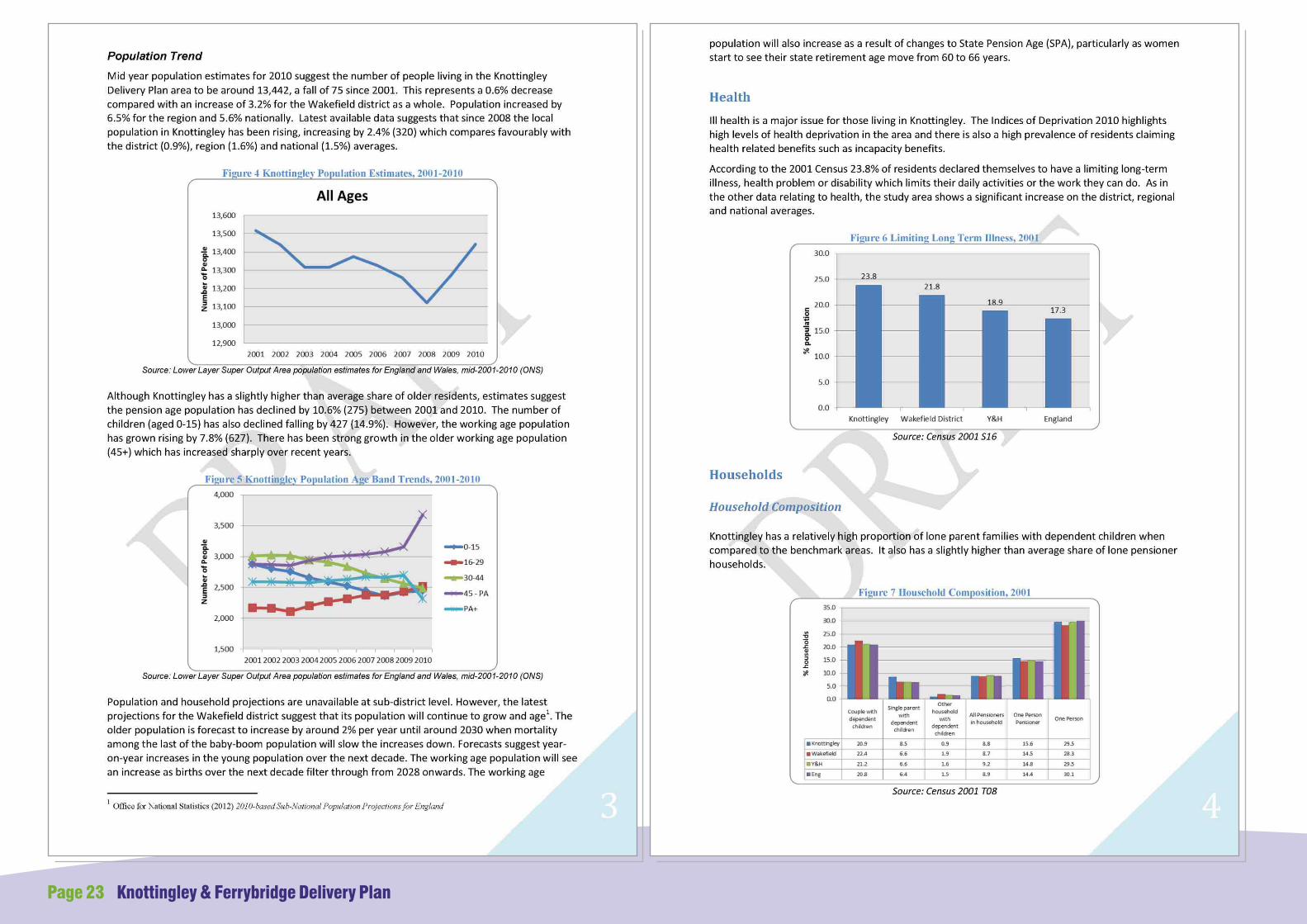
Page 23 Knottingley & Ferrybridge Delivery Plan

Knottingley & Ferrybridge Delivery Plan Page 24
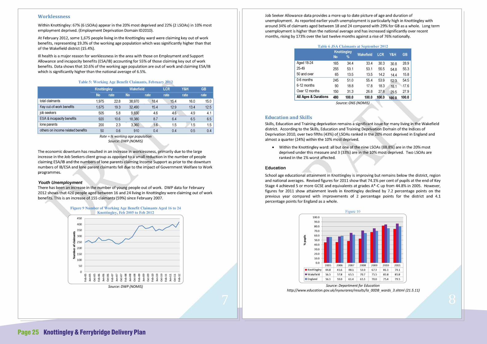
Page 25 Knottingley & Ferrybridge Delivery Plan

Knottingley & Ferrybridge Delivery Plan Page 26

Knottingley / Ferrybridge is characterised and defined by its significant road and rail infrastructure, beautiful waterways, major employment facilities such as Ferrybridge Power Station, Kings Mill, Ardagh Glass, and its heritage including the churches of St Botolph's and St Andrew's, sections of limestone walls, and remaining shipyards.
The Delivery Plan boundary covers significant employment and housing areas bordered to the north, south and east by green belt. For the purposes of informing future more detailed work, this large area of the Delivery Plan has been divided into a number of smaller character zones which are defined by their history, geography and / or function. Many of the zones are bordered by the railway line, major roads or waterways, which impacts on the legibility across the whole of the Knottingley/Ferrybridge locality.
As the Delivery Plan evolves, it is the Council's intention to focus in on each of the character zones in turn to produce an urban design based strategy for the future development and enhancement of the zone in itself and in so far as each contributes to the wider benefit of Knottingley and Ferrybridge as a whole. Following on from a detailed analysis of the existing visual and physical character of the area, a series of urban design based interventions will be put forward that will aim to maximise its potential. These will range from small scale, short term projects to larger initiatives which can be accomplished over a longer time period. The first character zone will be Hill Top, due to its potential to become a town centre focus for the wider area.
APPENDIX 3 - Character Zones
Historic Centre
1. Knottingley Conservation Area
Central Amenity Area
2. Hill Top
Employment Areas
3. Ferrybridge Power Station
4. Fernley Green -The Eastern Approach
5. Racca Green
Residential Areas
6. Broomhill
7. England Lane - Residential and Academy Area
8. Ferrybridge Estate
9. Ferrybridge Hill -The Northern Approach
10. Simpsons Lane / Warwick
11. The Island - Residential Riverside Amenity Area
Page 27 Knottingley & Ferrybridge Delivery Plan
Copyright GeoPerspectives 2009
Copyright GeoPerspectives 2009
© Crown copyright and database rights 2013Ordnance Survey 100019574
Historic Centre
1. Knottingley Conservation Area

3
42 5
Central Amenity Area
2. Hill Top
Knottingley & Ferrybridge Delivery Plan Page 28
Copyright GeoPerspectives 2009
Employment Areas
3. Ferrybridge Power Station
4. Fernley Green - The Eastern Approach
5. Racca Green
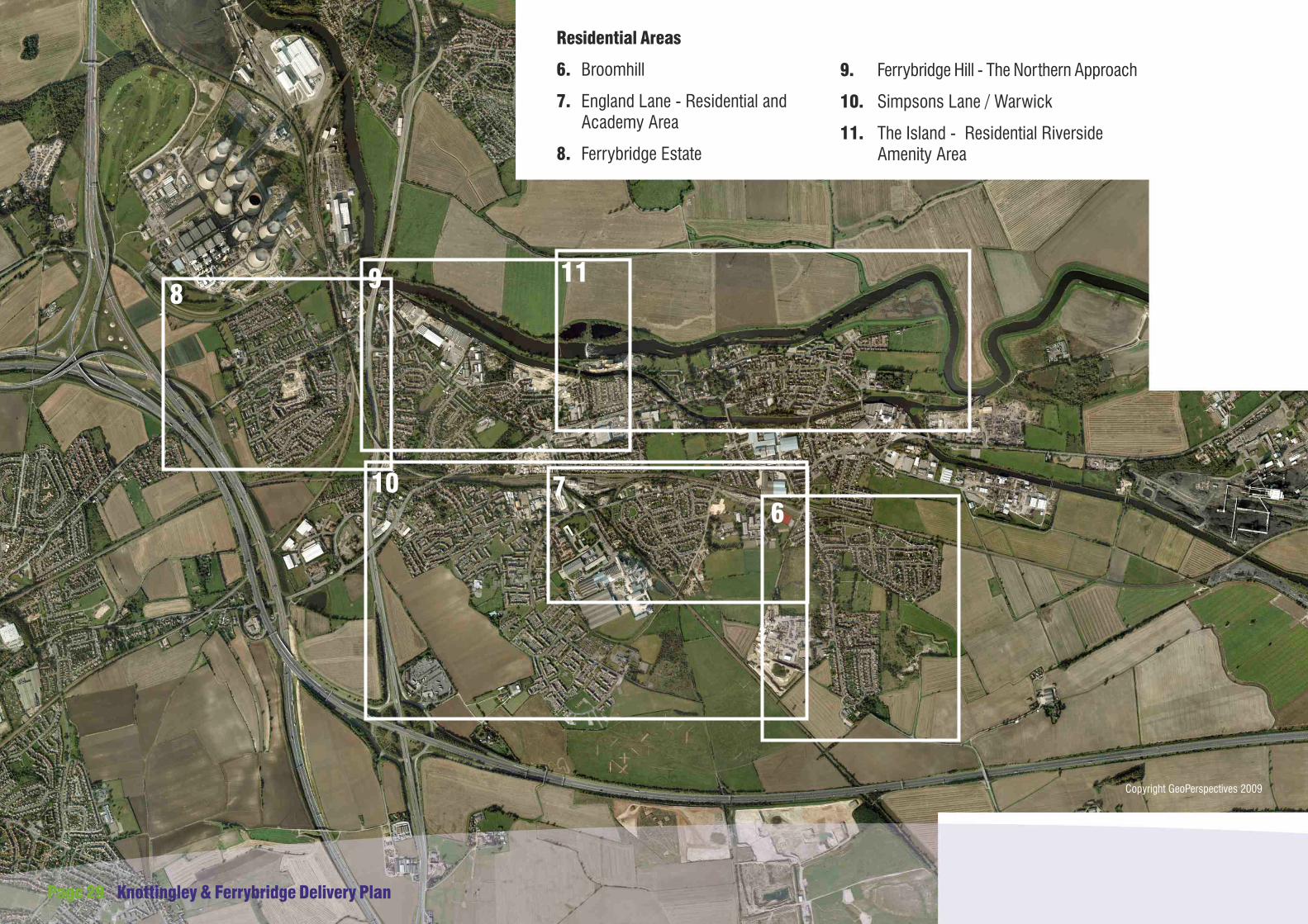
67
89
10
11
Residential Areas
6. Broomhill
7. England Lane - Residential and Academy Area
8. Ferrybridge Estate
Page 29 Knottingley & Ferrybridge Delivery Plan
9. Ferrybridge Hill - The Northern Approach
10. Simpsons Lane / Warwick
11. The Island - Residential Riverside Amenity Area
Copyright GeoPerspectives 2009

Knottingley & Ferrybridge Delivery Plan Page 30
If you live or work in the area affected by these proposals or wish to find out further information, please contact the Regeneration Team:
Tel: 01924 306630, or
Email: [email protected]
Wakefield Council,Economic Growth and Housing,Regeneration Team,Wakefield One,PO Box 700,Burton Street,WakefieldWF1 2EB
Further information