Embed Size (px)
Citation preview
Sunshine StateSTANDARDSSC.H.3.3.4: The studentknows that technologi-cal design shouldrequire taking intoaccount constraintssuch as natural laws,the properties of thematerials used, andeconomic, political,social, ethical, and aes-thetic values.
Chapter 6: Views of Earth Today 203
BEFORE, you learned
• The Earth system has four mainparts: atmosphere, hydrosphere,biosphere, and geosphere
• Technology is used to studyand map the Earth system
• The Earth system’s parts inter-act to shape Earth’s surface
NOW, you will learn
• What information maps canprovide about natural andhuman-made features
• How to find exact locations on Earth
• Why all maps distort Earth’ssurface
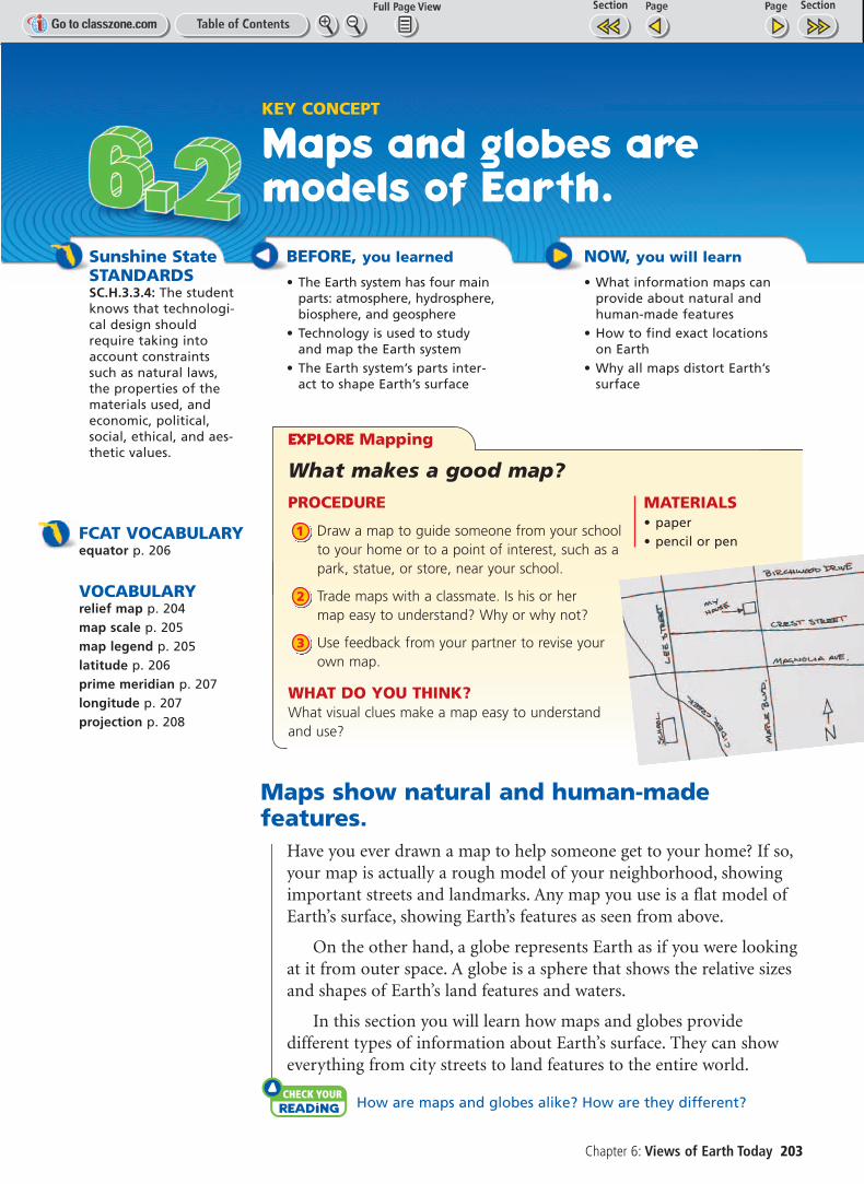
KEY CONCEPT
Maps and globes aremodels of Earth.
Maps show natural and human-madefeatures.
Have you ever drawn a map to help someone get to your home? If so,your map is actually a rough model of your neighborhood, showingimportant streets and landmarks. Any map you use is a flat model ofEarth’s surface, showing Earth’s features as seen from above.
On the other hand, a globe represents Earth as if you were lookingat it from outer space. A globe is a sphere that shows the relative sizesand shapes of Earth’s land features and waters.
In this section you will learn how maps and globes provide different types of information about Earth’s surface. They can showeverything from city streets to land features to the entire world.
check your reading How are maps and globes alike? How are they different?
EXPLORE Mapping
What makes a good map?
PROCEDURE
Draw a map to guide someone from your schoolto your home or to a point of interest, such as apark, statue, or store, near your school.
Trade maps with a classmate. Is his or hermap easy to understand? Why or why not?
Use feedback from your partner to revise yourown map.
WHAT DO YOU THINK?What visual clues make a map easy to understandand use?
3
2
1
MATERIALS• paper• pencil or penFCAT VOCABULARY
equator p. 206
VOCABULARYrelief map p. 204map scale p. 205map legend p. 205latitude p. 206prime meridian p. 207longitude p. 207projection p. 208

204 Unit 2: Earth’s Surface
Relief Map of United States
Mountains appear asripples on reliefmaps. Brown colorsrepresent areas highabove sea level.
Plateaus are mostlylevel and are nearmountain ranges.They often standhigh above sea level.
Plains show little reliefon the map. Dark greenrepresents areas at sealevel. Lighter greensrepresent areas up toor above sea level.
Land Features on MapsWhen scientists or travelers want to know what the landscape of anarea actually looks like, they will often use a relief map. A such as the one above, shows how high or low each feature is onEarth. A mapmaker uses photographs or satellite images to build athree-dimensional view of Earth’s surface. A relief map shows threemain types of land features: mountains, plains, and plateaus.
Mountains stand higher than the land around them. A mountain’sbase may cover several square kilometers. A group of mountains iscalled a mountain range. Mountain ranges connected in a long chainform a mountain belt. The Rocky Mountains in the United States arepart of a huge mountain belt that includes the Canadian Rockies andthe Andes Mountains in South America.
Plateaus have fairly level surfaces but stand high above sea level.Plateaus are often found near large mountain ranges. In the UnitedStates, the Colorado Plateau is about 3350 meters (11,000 ft) abovesea level. This plateau includes parts of Arizona, Colorado, NewMexico, and Utah.
Plains are gently rolling or flat features. The United States has twotypes of plains—coastal plains near the eastern and southeasternshores, and interior plains in the center of the nation. The interiorGreat Plains cover the middle third of the United States.
check your reading How is a plateau different from either a mountain or a plain?
relief map,VOCABULARYAdd a word triangle for relief map to your notebook.
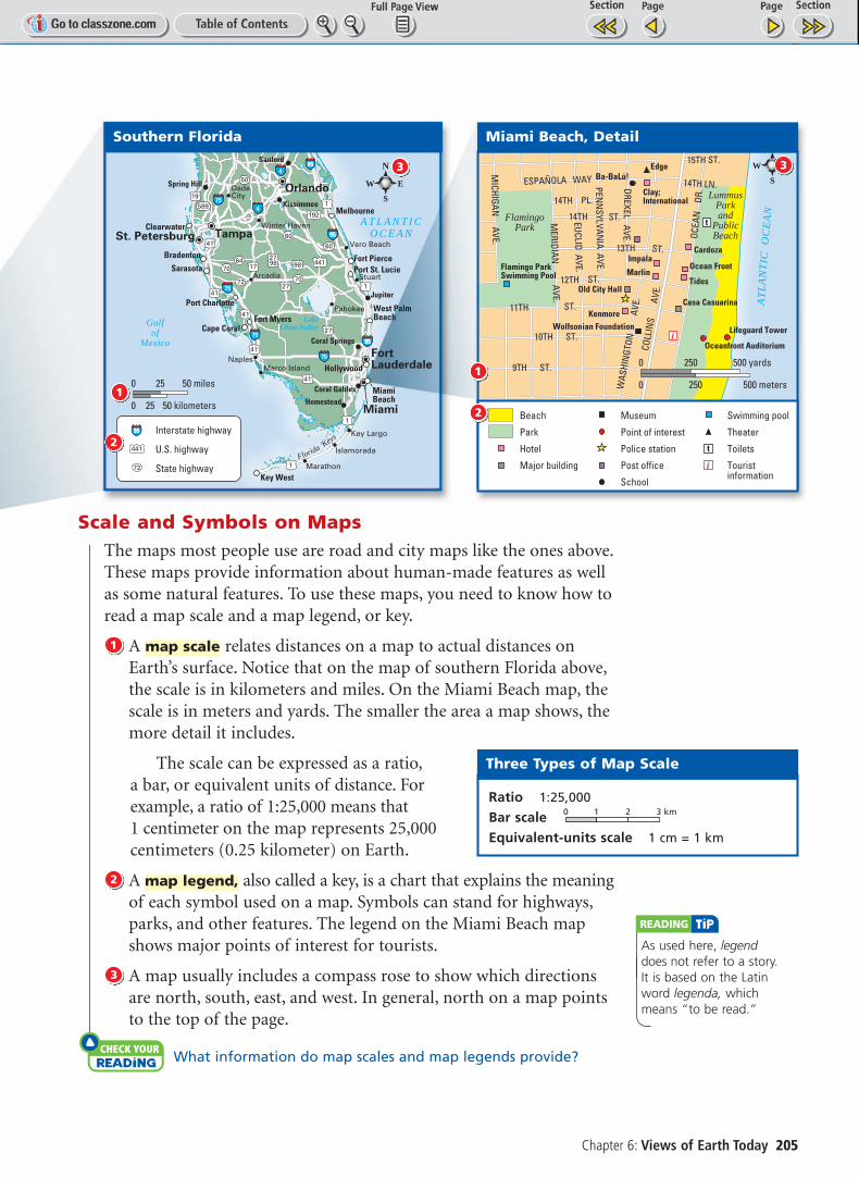
Scale and Symbols on MapsThe maps most people use are road and city maps like the ones above.These maps provide information about human-made features as wellas some natural features. To use these maps, you need to know how toread a map scale and a map legend, or key.
A relates distances on a map to actual distances onEarth’s surface. Notice that on the map of southern Florida above,the scale is in kilometers and miles. On the Miami Beach map, thescale is in meters and yards. The smaller the area a map shows, themore detail it includes.
The scale can be expressed as a ratio,a bar, or equivalent units of distance. Forexample, a ratio of 1:25,000 means that 1 centimeter on the map represents 25,000centimeters (0.25 kilometer) on Earth.
A also called a key, is a chart that explains the meaningof each symbol used on a map. Symbols can stand for highways,parks, and other features. The legend on the Miami Beach mapshows major points of interest for tourists.
A map usually includes a compass rose to show which directionsare north, south, east, and west. In general, north on a map pointsto the top of the page.
check your reading What information do map scales and map legends provide?
3
map legend,2
map scale1
Chapter 6: Views of Earth Today 205
reading tip
As used here, legenddoes not refer to a story. It is based on the Latinword legenda, which means “to be read.”
2798
41
41
41
27
2741
17
41
98
1
1
1
1
19
72 70
60
60
7064
50
589
441
192
9595
9595
9595
75
75
75
4
4
75
LakeOkeechobeeGulf
ofMexico
A T L A N T I CO C E A N
Florida Keys
Miami
Tampa
Orlando
St. Petersburg
FortLauderdale
Cape CoralFort Myers
Melbourne
Port Charlotte
Bradenton
SarasotaFort Pierce
West PalmBeach
MiamiBeach
Port St. Lucie
Hollywood
Clearwater
Key West
Sanford
Kissimmee
Spring Hill
Jupiter
Coral Springs
Homestead
Coral Gables
DadeCity
Naples
Vero Beach
Arcadia Stuart
Key Largo
Marathon
Marco Island
Winter Haven
Pahokee
Islamorada
Interstate highway
U.S. highway
State highway
9595
441
72
0 25 50 kilometers
0 25 50 miles
N
S
EW
Southern Florida
1
2
3
Flamingo ParkSwimming Pool
Wolfsonian Foundation
Old City Hall
Impala
Marlin
KenmoreCasa Casuarina
Tides
Ocean Front
Cardoza
Clay;International
EdgeBa-BaLú!
Lifeguard Tower
Oceanfront Auditorium
AT
LA
NT
ICO
CE
AN
10TH ST.
11TH ST.
COLL
INS
AVE.
9TH ST.
15TH ST.
14TH LN.
14TH PL.
ESPAÑOLA WAY
OCEA
N
DR.
PENN
SYLVANIA AVE.
MERIDIAN
AVE.
EUCLID AVE.
MICHIGAN
AVE.
WAS
HIN
GTON
AVE.
14TH ST.
13TH ST.
12TH ST.
DREXELAVE.
LummusParkand
PublicBeach
FlamingoPark
S
EW
0 250 500 meters
0 250 500 yards
MapQuest
Miami Beach, Detail
1
3
Beach
Park
Hotel
Major building
Museum
Point of interest
Police station
Post office
School
Swimming pool
Theater
Toilets
Touristinformation
2
Three Types of Map Scale
Ratio 1:25,000
Bar scale 0 1 2 3 km
Equivalent-units scale 1 cm = 1 km

reading tip
Hemi- is a Greek prefix meaning “half.”
206 Unit 2: Earth’s Surface
Latitude and longitude show locations on Earth.
Suppose you were lucky enough to find dinosaur bones in the desert.Would you know how to find that exact spot again? You would if youknew the longitude and latitude of the place. Latitude and longitudelines form an imaginary grid over the entire surface of Earth. Thisgrid provides everyone with the same tools for navigation. Using latitude and longitude, you can locate any place on the planet.
LatitudeLatitude is based on an imaginary line that circles Earth halfwaybetween the north and south poles. This line is called the and it divides Earth into northern and southern hemispheres.A hemisphere is one half of a sphere.
is a distance in degrees north or south of the equator,which is 0°. A degree is 1/360 of the distance around a full circle. If youstart at one point on the equator and travel all the way around theworld back to that point, you have traveled 360 degrees.
The illustration below shows that latitude lines are parallel to theequator and are evenly spaced between the equator and the poles.Also, latitude lines are always labeled north or south of the equator to
Latitude
equator,
Latitude and Longitude
W E S T E R NH E M I S P H E R E
E A S T E R NH E M I S P H E R E
Prim
e M
erid
ian
30° W 30° E
30° W
0°
30° S
60° S
30° N
60° N
30° E60° E60° W
Paris,France
Cairo,Egypt
N O R T H E R NH E M I S P H E R E
S O U T H E R NH E M I S P H E R E
Equator
30° S
30° N
Latitude is a distance indegrees north or south ofthe equator.
Longitude is a distance indegrees east or west of theprime meridian.
You can find a locationby noting where latitudeand longitude lines cross.
The equatordivides Earth intonorthern and southernhemispheres.
The prime meridiandivides Earth into eastern and westernhemispheres.
What are the approximate latitudes and longitudes of Cairo, Egypt, and Paris, France?
VISUALIZATIONCLASSZONE.COM
Explore how latitudeand longitude help you find locations onEarth’s surface.

reading tip
There is an easy way toremember the differencebetween latitude andlongitude. Think of longitudelines as the “long” lines thatgo from pole to pole.
show whether a location is in the northern or southern hemisphere.For instance, the North Pole is 90° north, or 90°N, while the SouthPole is 90° south, or 90°S. Latitude, however, is only half of what youneed to locate any spot on Earth. You also need to know its longitude.
LongitudeLongitude is based on an imaginary line that stretches from the NorthPole through Greenwich, England, to the South Pole. This line iscalled the Any place up to 180° west of the primemeridian is in the Western Hemisphere. Any place up to 180° east ofthe prime meridian is in the Eastern Hemisphere.
is a distance in degrees east or west of the primemeridian, which is 0°. Beginning at the prime meridian, longitudelines are numbered 0° to 180° west and 0° to 180° east.
Longitude lines are labeled east or west to indicate whether a location is in the eastern or western hemisphere. For example, thelongitude of Washington, D.C., is about 78° west, or 78°W. The city of Hamburg, Germany, is about 10° east, or 10°E. If you understandlatitude and longitude, you can find any spot on Earth’s surface.
check your reading Why do all cities in the United States have a north latitude and a west longitude?
Global Positioning SystemThe Global Positioning System (GPS) is a network ofsatellites that are used to find the latitude, longitude,and elevation, or height above sea level, of any site.Twenty-four GPS satellites circle Earth and send signalsthat are picked up by receivers on the surface. At leastthree satellites need to be above the horizon for GPS towork. A computer inside a receiver uses the satellitesignals to calculate the user’s exact location—latitude,longitude, and elevation. GPS is an accurate, easymethod for finding location.
GPS devices are used by many people, includingpilots, sailors, hikers, and map makers. Some cars nowhave GPS receivers and digital road maps stored intheir computers. A driver types in an address, and thecar’s computer finds the best way to get there.
check your reading Explain how GPS can help someone find theirexact location.
Longitude
prime meridian.
Chapter 6: Views of Earth Today 207
Never be lost again. This hiker turns on hisGPS unit to find out his current latitude andlongitude. He then locates these data on hismap to pinpoint his exact location.
Recall what you learnedabout location and positionin grade 6. Latitude andlongitude are another wayof describing position.
Content ReviewFLORIDA
Map projections distort the view of Earth’s surface.
The most accurate way to show Earth’s surface is on a globe. A globe,however, cannot show much detail, and it is awkward to carry. Peopleuse flat maps for their detail and convenience. A is a wayof representing Earth’s curved surface on a flat map. Mapmakers usedifferent types of projections, all of which distort, or misrepresent,Earth’s surface in different ways.
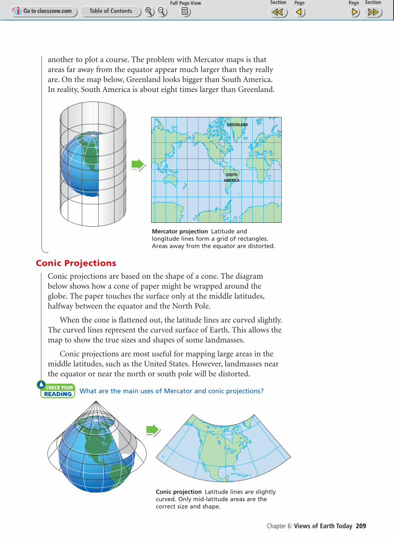
Cylindrical ProjectionThe Mercator projection shows Earth as if the map were a large cylin-der wrapped around the planet. The outlines of the landmasses andseas are then drawn onto the map. As shown in the diagram on page209, the cylinder is unrolled to form a flat map. Latitude and longi-tude appear as straight lines, forming a grid of rectangles.
The Mercator projection is useful for navigating at sea or in theair. It shows the entire world, except for regions near the poles, on onemap. Sailors and pilots can draw a straight line from one point to
projection
PROCEDURE
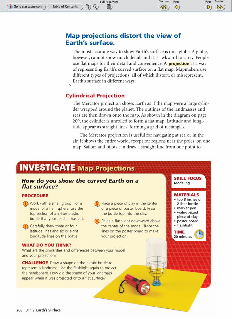
Work with a small group. For amodel of a hemisphere, use thetop section of a 2-liter plastic bottle that your teacher has cut.
Carefully draw three or fourlatitude lines and six or eightlongitude lines on the bottle.
Place a piece of clay in the centerof a piece of poster board. Pressthe bottle top into the clay.
Shine a flashlight downward abovethe center of the model. Trace thelines on the poster board to makeyour projection.
4
3
2
1
Map ProjectionsMap ProjectionsSKILL FOCUS Modeling
MATERIALS• top 8 inches of
2-liter bottle• marker pen• walnut-sized
piece of clay• poster board• flashlight
TIME20 minutes
How do you show the curved Earth on a flat surface?
WHAT DO YOU THINK?What are the similarities and differences between your model and your projection?
CHALLENGE Draw a shape on the plastic bottle to represent a landmass. Use the flashlight again to project the hemisphere. How did the shape of your landmass appear when it was projected onto a flat surface?
208 Unit 2: Earth’s Surface
Chapter 6: Views of Earth Today 209
another to plot a course. The problem with Mercator maps is thatareas far away from the equator appear much larger than they reallyare. On the map below, Greenland looks bigger than South America.In reality, South America is about eight times larger than Greenland.
Conic ProjectionsConic projections are based on the shape of a cone. The diagrambelow shows how a cone of paper might be wrapped around theglobe. The paper touches the surface only at the middle latitudes,halfway between the equator and the North Pole.
When the cone is flattened out, the latitude lines are curved slightly.The curved lines represent the curved surface of Earth. This allows themap to show the true sizes and shapes of some landmasses.
Conic projections are most useful for mapping large areas in themiddle latitudes, such as the United States. However, landmasses nearthe equator or near the north or south pole will be distorted.
check your reading What are the main uses of Mercator and conic projections?
Conic projection Latitude lines are slightlycurved. Only mid-latitude areas are thecorrect size and shape.
GREENLAND
SOUTHAMERICA
Mercator projection Latitude andlongitude lines form a grid of rectangles.Areas away from the equator are distorted.

210 Unit 2: Earth’s Surface
Planar ProjectionsPlanar projections were developed to help people find the shortestdistance between two points. They are drawn as if a circle of paperwere laid on a point on Earth’s surface. As you look at the diagrambelow, notice how the shape of the sphere is transferred to the flatmap. When a planar map represents the polar region, the longitudelines meet at the center like the spokes of a wheel.
A planar map is good for plotting ocean or air voyages and forshowing the north and south polar regions. However, landmasses farther away from the center point are greatly distorted.
The Mercator, conic, and planar projections are all attempts tosolve the problem of representing a curved surface on a flat map.Each projection can show certain areas of the world accurately butdistorts other areas.
check your reading What areas does the planar projection show accurately?
RESOURCE CENTERCLASSZONE.COM
Find out more aboutmap projections andhow they are used.
KEY CONCEPTS1. What natural and human-
made features can mapsshow? Give two examples of each.
2. Explain how latitude and longi-tude can help you locate anyplace on Earth.
3. Why do all flat maps distortEarth’s surface?
CRITICAL THINKING4. Provide Examples Imagine
that your family is on a longcar trip. What symbols on aroad map would you pay themost attention to? Explain.
5. Apply Use a world map tofind the approximate latitudesand longitudes of Moscow,Russia; Tokyo, Japan; Denver,Colorado; and La Paz, Bolivia.
CHALLENGE6. Apply Working with a partner
or with a small group, selectthe shortest airline route fromChicago to London, using aglobe and a Mercator map.Hint: Notice that as you gofarther north on the globe, the longitude lines becomecloser together.
Planar projection Only areas near thecenter point are the correct size and shape.