Embed Size (px)
Citation preview
Kempner Park
February 2011

i Galveston Master Neighborhood Plan
Table of Contents
Section 1 – Introduction
1.1 Executive Summary ..................................................... 1-1
1.2 Galveston Master Neighborhood Plan ................................ 1-2
1.3 The Planning Process in Kempner Park .............................. 1-2
1.4 Neighborhood Planning Area .......................................... 1-2
Section 2 – History
2.1 History .................................................................... 2-1
2.2 Impact of Hurricane Ike ................................................ 2-3
Section 3 – Existing Conditions
3.1 Overview ................................................................. 3-1
3.2 Demographics ........................................................... 3-1
3.3 Land Use and Zoning ................................................... 3-3
3.4 Urban Design ............................................................ 3-8
3.5 Housing .................................................................. 3-13
3.6 Economic Development ............................................... 3-15
3.7 Transportation & Infrastructure ..................................... 3-17
3.8 Safety .................................................................... 3-23
Section 4 – Goals, Opportunities & Actions
4.1 Overview ................................................................. 4-1
Goal #1 ................................................................... 4-1
Goal #2 ................................................................... 4-2
Goal #3 ................................................................... 4-3
Goal #4 ................................................................... 4-8
Goal #5 .................................................................. 4-11
Goal #6 .................................................................. 4-12
Goal #7 .................................................................. 4-14
Goal #8 .................................................................. 4-16
Goal #9 .................................................................. 4-17
Section 5 – Implementation
Appendices
Appendix A –City Wide Infrastructure

ii Galveston Master Neighborhood Plan
1-1 Galveston Master Neighborhood Plan
Section 1 Introduction
1.1 Executive Summary The neighborhood planning process in Kempner Park began with a community meeting
where residents identified their top planning priorities for the neighborhood.
Infrastructure – improve street and alley conditions, major corridors and
stormwater infrastructure to provide adequate drainage and flood control during
rain event, and improve the overall character of the neighborhood planning area.
Economic Development – attract middle-income grocery stores to locate within the
neighborhood planning area.
Recreation and Open Space – capitalize on existing open spaces, community
facilities and event space.
Housing – develop vacant lots with moderately priced, single-family homes and
demolish or renovate vacant and deteriorated buildings throughout the
neighborhood planning area.
Urban Design – enforce or enact littering laws to discourage littering in the
neighborhood planning area.
Safety: Increase numbers of law enforcement personnel and target high crime
areas.
These issues formed the basis for the neighborhood goals, which Kempner Park residents
developed at a subsequent meeting. These goals represent long and short-term objectives
and they are the foundation for the analysis and the recommendations in this plan.
Goal #1—Create a more “pedestrian friendly” neighborhood with the development
of continuous and contiguous sidewalks.
Goal #2—Improve street and alley conditions throughout the neighborhood planning
area and establish a regular maintenance schedule to maintain these roadways.
Goal #3—Construct stormwater infrastructure improvements and continue to
maintain existing stormwater infrastructure to provide adequate drainage and flood
control during rain events.
Goal #4—Identify and improve major corridors with the addition of bicycle lanes,
better signage, lighting, landscaping, etc.
Goal #5— Attract middle-income grocery stores and other small-scale commercial
establishments to locate within the neighborhood.
Goal #6—Capitalize on existing open spaces, community facilities and event spaces
in Kempner Park.
Goal #7—Develop and infill vacant lots throughout the neighborhood with residential
uses that fit into the current character of the neighborhood planning area while
demolishing or rehabilitating derelict, vacant and deteriorated buildings.
Goal #9—Have better enforcement of littering laws to curb the amount of litter in
the neighborhood.
Goal #10—Reduce crime and the perception of crime throughout the neighborhood.
1-2 Galveston Master Neighborhood Plan
1.2 Galveston Master Neighborhood Plan The Galveston Master Neighborhood Plan is composed of 17 distinct documents that focus on
17 neighborhood-planning areas within the City of Galveston. One of the recommendations
of Galveston’s Long Term Community Recovery Plan, which was developed in the wake of
Hurricane Ike, was the creation of a master document that consolidates and coordinates
social, environmental and economic planning at the neighborhood scale. Infill development,
streetscape improvements and other fine-grain issues were determined to be best addressed
by immediate neighbors and the surrounding community.
The Master Neighborhood Plan is a direct result of the Recovery Plan’s recommendation and
it provides a tool for the City and neighborhood’s residents to use in tandem with
Galveston’s Comprehensive Plan. The neighborhood plans that comprise the Master
Neighborhood Plan address the issues that are unique to each neighborhood, as well as
neighborhood-specific instances of citywide issues that are addressed in the Comprehensive
Plan. This document identifies the neighborhood’s planning priorities and determines ways
to advance and implement these priorities.
1.3 The Planning Process in Kempner Park The Kempner Park Neighborhood Plan was developed primarily as a series of meeting held
from September 2010 to January 2011. Planning area residents came together to discuss and
debate their priorities for Kempner Park’s future. In consultation with the City’s planning
team, planning area residents then worked to refine their goals and select actions and
opportunities for meeting the goals. Finally, implementation measures for carrying out the
action items were prepared.
1.4 Neighborhood Planning Area Kempner Park is located on the Gulf side of the island and borders the Silk Stocking Historic
District. It is south of the Old Central/Carver Park neighborhood planning area and borders
the San Jacinto neighborhood planning area on the east side and the Lasker Park
neighborhood planning area on the west side. The planning area spans about a mile between
39th Street on the west and 25th Street on the east and a slightly lesser distance between
Avenue M to the north and Avenue S to the south. The southeastern corner of the planning
area includes a small stretch of the Seawall.

1-3 Galveston Master Neighborhood Plan
Figure 1.1 Kempner Park Neighborhood Planning Area
1-4 Galveston Master Neighborhood Plan
2-1 Galveston Master Neighborhood Plan
Section 2 History
2.1 History The brief history of the neighborhood provides a background for the discussion of the
current-day neighborhood in the other sections of the plan.
Historic Figures Michel B. Menard (whose residence at 1605 33rd Street is described below) was one of the
founders of the City of Galveston. Originally from La
Prairie, Canada, located north of Montreal, Menard
was prominent in the founding of the City after
obtaining control of the Galveston City Company
land “through a complicated process” (McComb,
1986). In 1833, when Menard was interested in
purchasing the land, Mexican-born citizens could
only acquire land. Menard acted as Juan N. Seguin’s
attorney to obtain a survey on 4,605 acres of land,
which would ultimately encompass the eastern end
of the island, including the Kempner Park
neighborhood planning area. The dealings that
finally led to Menard owning the land included
transferring the land to Thomas F. McKinney who
then resold it to Menard on December 10, 1836
(McComb, 1986). Menard and nine associates
including McKinney, Samuel May Williams, Mosely
Baker, John K. Allen, Augustus C. Allen, William H.
Jack, William Hardin, A.J. Gates and David White
petitioned the Republic of Texas for confirmation of
the claim, which was granted on December 9, 1836
in exchange for $50,000 “in cash or acceptable
materials in New Orleans” (McComb, 1986).
After these dealings, the City was incorporated in
1839, following the survey, division and sale of lots
in the eastern part of the island.
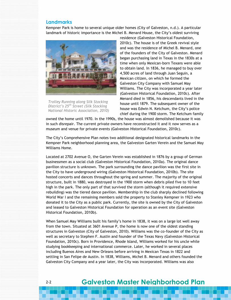
Historic Districts The Kempner Park planning area includes the Silk Stocking Historic District. The District
spans approximately 10 blocks along 24th and 25th Streets and contains a collection of
historic homes from the Civil War through World War II eras (City of Galveston, n.d.; Silk
Stocking National Historic District Association, 2010).[m1]
Formed in 1975, the District was formally listed in the National Register of Historic Places in
1996. Several of the homes in the neighborhood planning area are from the Queen Anne
style of architecture and also have National Register status (SSNHD, 2010).[m2]
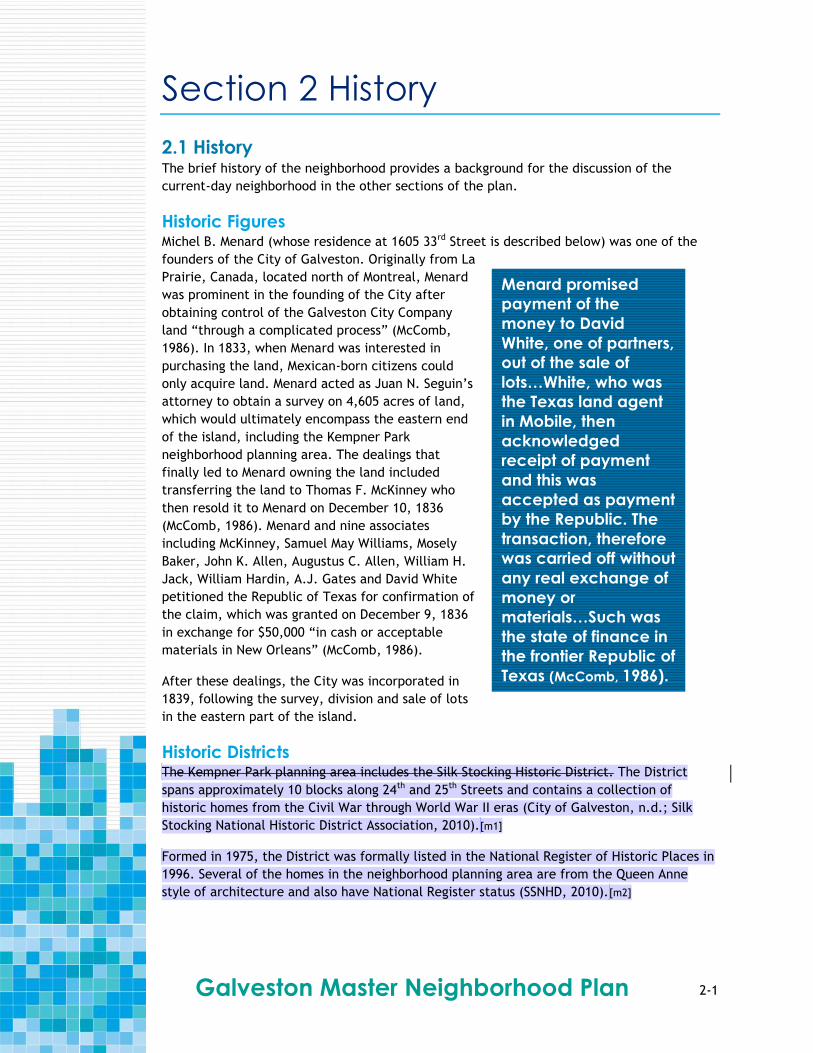
Menard promised
payment of the
money to David
White, one of partners,
out of the sale of
lots…White, who was
the Texas land agent
in Mobile, then
acknowledged
receipt of payment
and this was
accepted as payment
by the Republic. The
transaction, therefore
was carried off without
any real exchange of
money or
materials…Such was
the state of finance in
the frontier Republic of
Texas (McComb, 1986).
2-2 Galveston Master Neighborhood Plan
Landmarks Kempner Park is home to several unique older homes (City of Galveston, n.d.). A particular
landmark of historic importance is the Michel B. Menard House, the City’s oldest surviving
residence (Galveston Historical Foundation,
2010c). The house is of the Greek revival style
and was the residence of Michel B. Menard, one
of the founders of the City of Galveston. Menard
began purchasing land in Texas in the 1830s at a
time when only Mexican-born Texans were able
to obtain land. In 1836, he managed to buy over
4,500 acres of land through Juan Seguin, a
Mexican citizen, on which he formed the
Galveston City Company with Samuel May
Williams. The City was incorporated a year later
(Galveston Historical Foundation, 2010c). After
Menard died in 1856, his descendants lived in the
house until 1879. The subsequent owner of the
house was Edwin N. Ketchum, the City’s police
chief during the 1900 storm. The Ketchum family
owned the home until 1970. In the 1990s, the house was almost demolished because it was
in such disrepair. The current private owners have reconstructed it and it now serves as a
museum and venue for private events (Galveston Historical Foundation, 2010c).
The City’s Comprehensive Plan notes two additional designated historical landmarks in the
Kempner Park neighborhood planning area, the Galveston Garten Verein and the Samuel May
Williams Home.
Located at 2702 Avenue O, the Garten Verein was established in 1876 by a group of German
businessmen as a social club (Galveston Historical Foundation, 2010a). The original dance
pavilion structure is unknown. The park surrounding the dance pavilion was the first site in
the City to have underground wiring (Galveston Historical Foundation, 2010b). The site
hosted concerts and dances throughout the spring and summer. The majority of the original
structure, built in 1880, was destroyed in the 1900 storm when debris piled five to 10 feet
high in the park. The only part of that survived the storm (although it required extensive
rebuilding) was the tiered dance pavilion. Membership in the club sharply declined following
World War I and the remaining members sold the property to Stanley Kempner in 1923 who
donated it to the City as a public park. Currently, the site is owned by the City of Galveston
and leased to Galveston Historical Foundation for operation as an event site (Galveston
Historical Foundation, 2010b).
When Samuel May Williams built his family’s home in 1838, it was on a large lot well away
from the town. Situated at 3601 Avenue P, the home is now one of the oldest standing
structures in Galveston (City of Galveston, 2010). Williams was the co-founder of the City as
well as secretary to Stephen F. Austin and founder of the Texas Navy (Galveston Historical
Foundation, 2010c). Born in Providence, Rhode Island, Williams worked for his uncle while
studying bookkeeping and international commerce. Later, he worked in several places
including Buenos Aires and New Orleans before arriving in Mexican Texas in 1822 and
settling in San Felipe de Austin. In 1838, Williams, Michel B. Menard and others founded the
Galveston City Company and a year later, the City was incorporated. Williams was also
Trolley Running along Silk Stocking District’s 25th Street (Silk Stocking National Historic Association, 2010)
2-3 Galveston Master Neighborhood Plan
responsible for founding Texas’ first bank. The Galveston Historical Foundation now owns
the Williams’ home (Galveston Historical Foundation, 2010d).
References City of Galveston, 2010. City of Galveston Landmarks website. Accessed on August 25, 2010.
Available online at:
www.cityofgalveston.org/city_services/planning_and_community_dev/plan_landmarks.cfm
City of Galveston, no date. Kempner Park Neighborhood Plan.
Galveston Historical Foundation, 2010a. Garten Verein website. Accessed August 25, 2010.
Available online at: www.galvestonhistory.org/1880_Garten_Verein.asp
Galveston Historical Foundation, 2010b. Garten Verein historical information website.
Accessed August 25, 2010. Available online at:
www.galvestonhistory.org/1880_Garten_Verein1.asp
Galveston Historical Foundation, 2010c. 1838 Michel B. Menard House historical information
website. Accessed August 31, 2010. Available online at:
www.galvestonhistory.org/1838_Michel_B_Menard_House.asp
Galveston Historical Foundation, 2010d. Samuel May Williams House historical information
website. Accessed August 25, 2010. Available online at:
www.galvestonhistory.org/1839_Samuel_May_Williams_House.asp
McComb, David G., 1986. Galveston: A History. University of Texas Press. Austin, Texas.
Silk Stocking National Historic District Neighborhood Association (SSNHD), 2010. SSNHD
website. Accessed August 31, 2010. Available online at: http://silkstockinggalveston.org/
2.2 Impact of Hurricane Ike Hurricane Ike made landfall on the east side of Galveston Island damaging the majority of
homes in Kempner Park. Of the housing properties in Kempner Park, 90 percent were
affected by the storm to some degree. One percent of housing properties was classified as
substantially damaged or destroyed and 89 percent experience minor damage. The
neighborhood planning area continues to recover from the disaster.[m3]
2-4 Galveston Master Neighborhood Plan
3-1 Galveston Master Neighborhood Plan
Section 3 Existing Conditions
3.1 Overview The Existing Conditions section discusses several characteristic of the neighborhood,
including the people who live here, home, businesses and public places, among others.
Data presented in the following sections are from the 1990 and 2000 U.S. Censuses; the City
of Galveston Planning and Development Department; and the University of Texas Medical
Branch (UTMB). Due to the timing of the neighborhood planning process and the scheduled
release of the 2010 U.S. Census results, those data are not reflected in this plan. When the
data are available later in 2011, it is strongly encouraged that further analysis be carried
out, particularly to incorporate changes that have occurred due to Hurricane Ike.
3.2 Demographics Kempner Park is one of the larger neighborhood planning areas in Galveston with a
population of 5,692 in 2000. The population of the neighborhood slightly decreased 7.4
percent from 1990 to 2000. Table 3.1 shows the age distribution of the population remained
relatively unchanged between census years. The only age group that showed significant
change was the 40 to 49 age group, which increased 5.5 percent. In 2000, the median age
was 37 years old.
Table 3.1 Population and Age
AGE 1990 (%) 2000 (%) 2010 (%)
0 – 4 6.6 5.8
5 – 17 19.7 8.1
18 – 21 4.7 5.9
22 – 29 14.5 9.9
30 – 39 16.1 14.5
40 – 49 10.6 16
50 – 64 15.8 14.6
65 and up 15.1 15.3
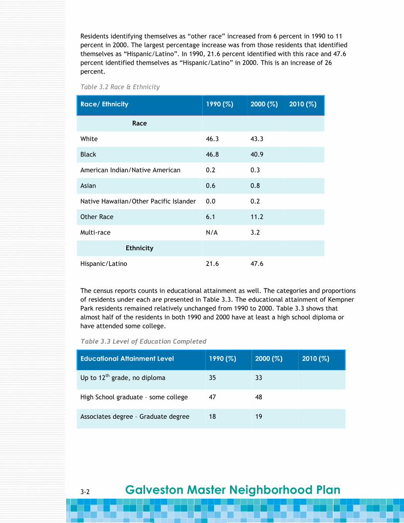
The ethnic makeup of Kempner Park has also remained unchanged from 1990 to 2000 (see
Table 3.2). Approximately 46.3 percent of residents identified themselves racially as
“white” in 1990 and 43.3 percent identified themselves as “white” in 2000. In 2000, 40.9
percent identified themselves as “black”, which was down from 46.8 percent in 1990.
Galveston Master Neighborhood Plan
3-2
Residents identifying themselves as “other race” increased from 6 percent in 1990 to 11
percent in 2000. The largest percentage increase was from those residents that identified
themselves as “Hispanic/Latino”. In 1990, 21.6 percent identified with this race and 47.6
percent identified themselves as “Hispanic/Latino” in 2000. This is an increase of 26
percent.
Table 3.2 Race & Ethnicity
Race/ Ethnicity 1990 (%) 2000 (%) 2010 (%)
Race
White 46.3 43.3
Black 46.8 40.9
American Indian/Native American 0.2 0.3
Asian 0.6 0.8
Native Hawaiian/Other Pacific Islander 0.0 0.2
Other Race 6.1 11.2
Multi-race N/A 3.2
Ethnicity
Hispanic/Latino 21.6 47.6
The census reports counts in educational attainment as well. The categories and proportions
of residents under each are presented in Table 3.3. The educational attainment of Kempner
Park residents remained relatively unchanged from 1990 to 2000. Table 3.3 shows that
almost half of the residents in both 1990 and 2000 have at least a high school diploma or
have attended some college.
Table 3.3 Level of Education Completed
Educational Attainment Level 1990 (%) 2000 (%) 2010 (%)
Up to 12th grade, no diploma 35 33
High School graduate – some college 47 48
Associates degree – Graduate degree 18 19

3-3 Galveston Master Neighborhood Plan
Kempner Park shows a positive trend in household income levels (see Table 3.4). These
levels increased slightly from 1990 to 2000. There are a greater proportion of residents
making more money in 2000 than in 1990. The percentage of residents making less than
$25,000 decreased 15.6 percent between 1990 and 2000. The income range that showed the
largest proportional increase was $50,000 to $74,999, which increased by 6.5 percent.
Table 3. 4 Household Income
Income Range 1990 (%) 2000 (%) 2010 (%)
Less than $25,000 61.8 46.2
$25,000 - $49,999 29.0 31.3
$50,000 - $74,999 6.4 12.9
$75,000 - $99,999 1.3 6.2
$100,000 - $149,999 0.7 2.3
$150,000 or more 0.9 1.2
For the most part, the Kempner Park population remained unchanged. Residents are mostly
middle-aged and continue to be educated with at least a high school degree diploma and
have an increasing household income.
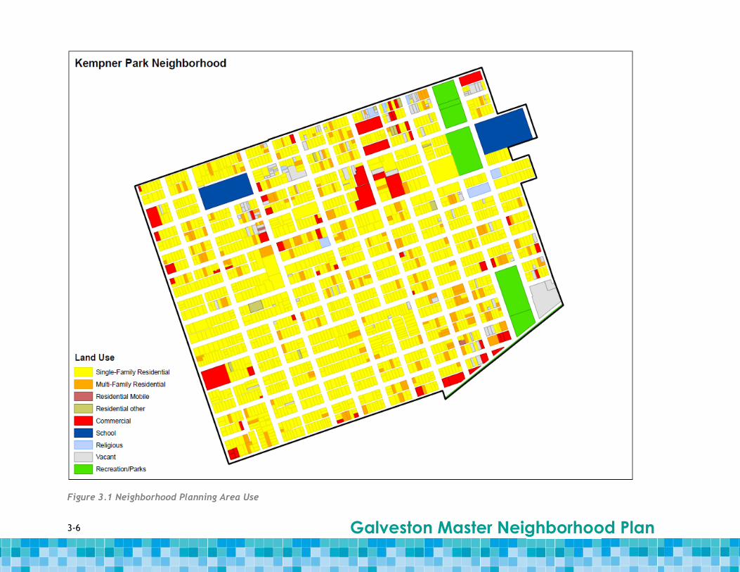
3.3 Land Use and Zoning Kempner Park is predominantly a single-family residential neighborhood, which comprises
approximately 71 percent of the planning area total land area. The remaining land use
consists of multi-family housing (eight percent) and a negligible presence of mobile and
“other” residential uses (less than one percent). All together, four-fifths of the land in
Kempner Park consists of residential land uses. Although many of the Kempner Park
residences are large-scale home, the neighborhood planning area is largely middle-class[m4].
Commercial land uses comprise approximately six percent of the land area. These land uses
are scattered throughout the planning area, with concentrations nearest to the Seawall,
Broadway Street [m5]and along 39th Rear Street. There are two large schools within Kempner
Park, Morgan Elementary and the Chancery Office for the Diocese of Galveston-Houston,
which is designated as a “school” use. These schools utilize nearly 12 acres of land. In
addition, three large parks offer additional amenities to this planning area and provide over
15 acres of open space to the residents. The parks are concentrated along the eastern side
of the planning area between 28th Street and 27th Rear Street. Courville Stadium and its
adjacent field are located the furthest north, Kempner Park is just south of the stadium
across Avenue N and Menard Park, which houses Galveston Parks and Recreation, is the
farthest south and abuts the Seawall.
Galveston Master Neighborhood Plan
3-4
Table 3.5 Land Use in Kempner Park
Kempner Park
Land Use Acreage Portion
Commercial 17.25 6.1%
Multi-Family Residential 21.89 7.8%
Recreation/Parks 15.51 5.5%
Religious 2.17 0.8%
Residential Mobile/Other 1.75 0.6%
School 11.47 4.1%
Single-Family Residential 199.33 70.8%
Vacant 12.31 4.4%
Total 281.68 100.0%
Just over 90 percent of Kempner Park is zoned for residential development (specifically
General Residence, 1F-4 and MF-1) and the other approximate 10 percent is commercially
zoned as Neighborhood Services (see Table 3.6). In addition, small portions of the planning
area fall within the Seawall Development Zone overlay (SDZ) (7.8 percent) and the High
Height and Density Development Zone overlay (HDDZ) (8.3 percent). The Seawall Overlay is
meant to accommodate businesses and uses that are compatible with the nearby beach and
tourist activities. Development within the HDDZ is allowed to have a greater density than
the underlying base zoning would otherwise permit, while allowing the community and City
to manage development to ensure that it has design, landscaping, transportation and
drainage characteristics that complement the surrounding neighborhood.
Table 3.6 Zoning in Kempner Park
Base Zoning
Zoning District Acreage Portion of Area
Residential 253.84 90.4%
Commercial 26.88 9.6%
Total Zoned Area 280.72 100.0%
Overlay Zoning
Seawall 21.97 7.8%
High Density 23.36 8.3%

3-5 Galveston Master Neighborhood Plan
As one of the older neighborhoods, Kempner Park’s settlement patterns have led to a
relatively dense population. Compared to the median density of ten people per acre in 2000
for all neighborhoods in the MNP, Kempner Park accommodates approximately 20 persons
per acres. With such a high population density, it is doubly fortunate that the planning area
has no registered Brownfield sites within its boundaries.
While there are quite a few multi-family residential uses throughout the planning area,
Kempner Park is a medium-density, single-family residential neighborhood planning area. In
addition, the residents have access to commercial uses near the Seawall and along Avenue
S.[m6]
3-6 Galveston Master Neighborhood Plan
Figure 3.1 Land Use, Lake Madeline Neighborhood Planning Area
Figure 3.1 Neighborhood Planning Area Use

3-7 Galveston Master Neighborhood Plan
Figure 3.2 Zoning

3-8 Galveston Master Neighborhood Plan
3.4 Urban Design
Housing and Building Styles Located between the San Jacinto and Denver Court-Fort Crockett neighborhood planning
areas[m7] with its southern edge bordering the Seawall, Kempner Park has the fourth highest
population density of all of the neighborhood planning areas on the island, approximately
20.2 people per square mile. Development consists primarily of single-family residential
with some multi-family residential, commercial, school, religious and recreation uses. There
are also some vacant lots interspersed among all of the development.
The majority of the planning area, from 28th Street west to its border with Lasker Park
Neighborhood planning area is dense, mainly single-family residential development. Single-
family homes are predominantly one and two-stories. Major architectural stylistic influences
throughout the planning area are craftsman, modern, art deco, classical revival and Queen
Anne (see Figure 3.3).
The neighborhood planning area borders the bayou and the West Bay and much of the
development, both residential and industrial, is clustered along the waterfront. Extending
west from its border with Robert Cohen, there is mainly residential development
interspersed with a few commercial uses. The residential developments are a mix of larger
single-family homes as well as a couple multi-family developments. The residential
properties at this eastern end of the planning area are spread out with large areas of open
or vacant land in between.
Kempner Park is home to several unique older homes (City of Galveston, n.d.). A particular
landmark of historic importance is the Michel B. Menard House, which is the city’s oldest
surviving residence (Galveston Historical Foundation, 2010a). The house is of the Greek
revival style and was the residence of Michel B. Menard, one of the founders of the City of
Galveston.[m8]

3-9 Galveston Master Neighborhood Plan
Figure 3.3 Kempner Park Housing Stylistic Influences
3-10 Galveston Master Neighborhood Plan
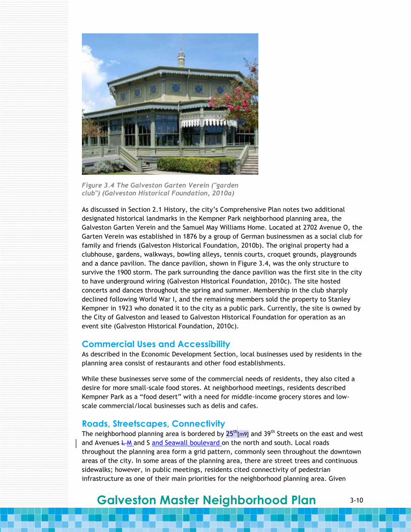
As discussed in Section 2.1 History, the city’s Comprehensive Plan notes two additional
designated historical landmarks in the Kempner Park neighborhood planning area, the
Galveston Garten Verein and the Samuel May Williams Home. Located at 2702 Avenue O, the
Garten Verein was established in 1876 by a group of German businessmen as a social club for
family and friends (Galveston Historical Foundation, 2010b). The original property had a
clubhouse, gardens, walkways, bowling alleys, tennis courts, croquet grounds, playgrounds
and a dance pavilion. The dance pavilion, shown in Figure 3.4, was the only structure to
survive the 1900 storm. The park surrounding the dance pavilion was the first site in the city
to have underground wiring (Galveston Historical Foundation, 2010c). The site hosted
concerts and dances throughout the spring and summer. Membership in the club sharply
declined following World War I, and the remaining members sold the property to Stanley
Kempner in 1923 who donated it to the city as a public park. Currently, the site is owned by
the City of Galveston and leased to Galveston Historical Foundation for operation as an
event site (Galveston Historical Foundation, 2010c).
Commercial Uses and Accessibility As described in the Economic Development Section, local businesses used by residents in the
planning area consist of restaurants and other food establishments.
While these businesses serve some of the commercial needs of residents, they also cited a
desire for more small-scale food stores. At neighborhood meetings, residents described
Kempner Park as a “food desert” with a need for middle-income grocery stores and low-
scale commercial/local businesses such as delis and cafes.
Roads, Streetscapes, Connectivity The neighborhood planning area is bordered by 25th
[m9] and 39th Streets on the east and west
and Avenues L M and S and Seawall boulevard on the north and south. Local roads
throughout the planning area form a grid pattern, commonly seen throughout the downtown
areas of the city. In some areas of the planning area, there are street trees and continuous
sidewalks; however, in public meetings, residents cited connectivity of pedestrian
infrastructure as one of their main priorities for the neighborhood planning area. Given
Figure 3.4 The Galveston Garten Verein ("garden club") (Galveston Historical Foundation, 2010a)
3-11 Galveston Master Neighborhood Plan
existing open spaces and the easy-to-maneuver grid pattern of local roads in the planning
area, the addition of continuous sidewalks, bicycle lanes, better signage and shade trees
could greatly increase pedestrian mobility and reduce dependence on cars.
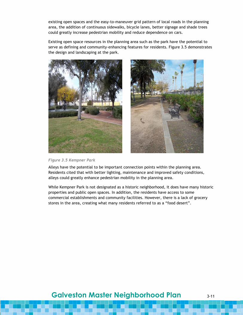
Existing open space resources in the planning area such as the park have the potential to
serve as defining and community-enhancing features for residents. Figure 3.5 demonstrates
the design and landscaping at the park.
Figure 3.5 Kempner Park
Alleys have the potential to be important connection points within the planning area.
Residents cited that with better lighting, maintenance and improved safety conditions,
alleys could greatly enhance pedestrian mobility in the planning area.
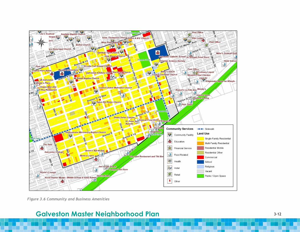
While Kempner Park is not designated as a historic neighborhood, it does have many historic
properties and public open spaces. In addition, the residents have access to some
commercial establishments and community facilities. However, there is a lack of grocery
stores in the area, creating what many residents referred to as a “food desert”.
3-12 Galveston Master Neighborhood Plan
Figure 3.6 Community and Business Amenities

3-13 Galveston Master Neighborhood Plan
3.5 Housing
Housing by Occupancy & Tenure As discussed above, the vast majority of land in Kempner Park is used for single-family
residences with a small portion of multi-family housing and a negligible presence of mobile
and “other” residential uses. The U.S. Census reports that there was a slight decrease of
eight percent in the total number of housing units from 1990 to 2000. The majority of the
units were occupied, with 81 percent occupied in 1990 and 84 percent occupied in 2000 (see
Table 3.7). Of those occupied units, the proportion of owner-occupied units decreases
slightly from 55.7 percent in 1990 to 52.5 percent in 2000.
Of the total vacant units in 1990, 43.3 percent were for rent. In 2000, vacant units for rent
decreased to 37.4 percent of the total vacant units. The percentage of vacant units for sale
decreased from 17.4 percent in 1990 to 11.3 percent in 2000. There were 82 residential
building permits issued in 2009 indicating redevelopment activity.
In 2009, approximately 56 percent of single-family residences were assumed to be owner-
occupied yearlong because they have homestead exemptions, which helps lower the
property taxes on primary residences by lower the home’s taxable value. Citywide there are
higher concentrations of parcels with homestead exemptions in the City’s urban core.
Table 3.7 Occupancy ad Tenure
1990 2000 2010
Quantity % of Total
Quantity % of Total
Quantity % of Total
Total Housing Units 2,928 100.0% 2,687 100.0%
Occupied Housing Units 2,371 81.0% 2,270 84.5%
Owner-Occupied Housing Units
1,320 45.1% 1,192 44.4%
Renter-Occupied Housing Units
1,051 35.9% 1,078 40.1%
Vacant Housing Units 557 19.0% 417 15.5%
For rent 241 8.2% 156 5.8%
For sale only 91 3.3% 47 1.8%
Rented or sold, not occupied 48 1.6% 45 1.7%
Seasonal, recreational, occasional use
11 0.4% 22 0.8%
Migrant workers 0 0.0% 0 0.0%
Other vacant 160 5.5% 147 5.5%
Galveston Master Neighborhood Plan
3-14
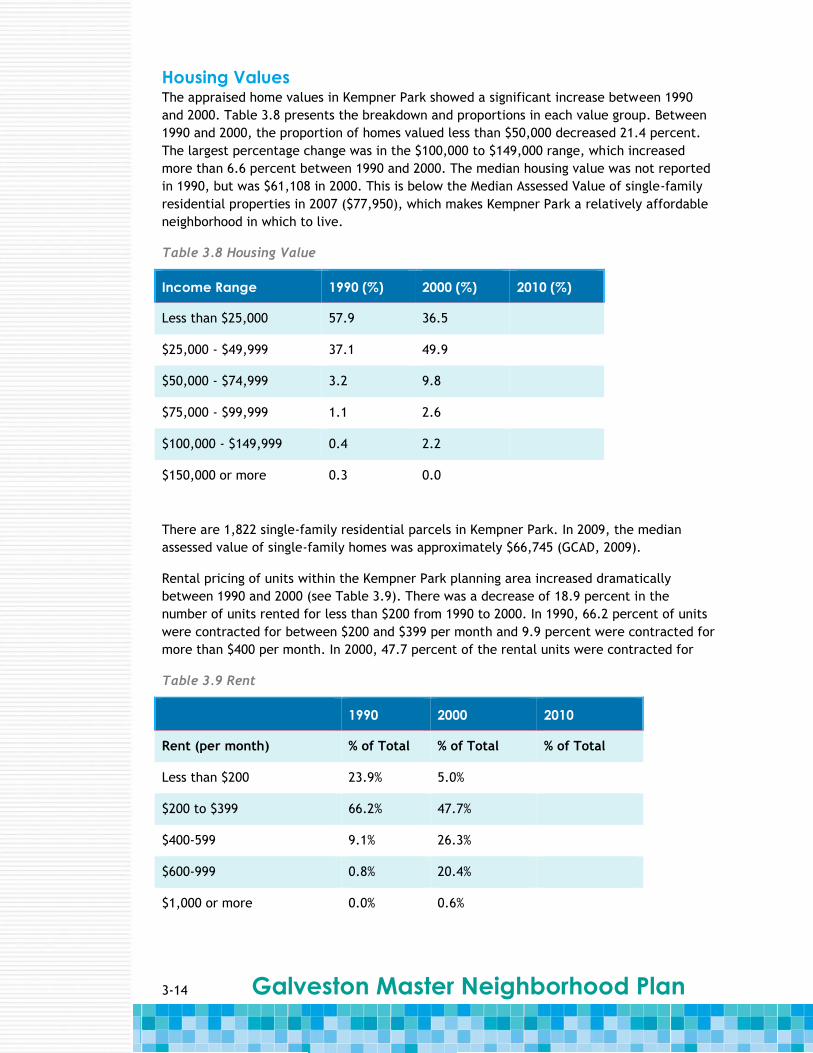
Housing Values The appraised home values in Kempner Park showed a significant increase between 1990
and 2000. Table 3.8 presents the breakdown and proportions in each value group. Between
1990 and 2000, the proportion of homes valued less than $50,000 decreased 21.4 percent.
The largest percentage change was in the $100,000 to $149,000 range, which increased
more than 6.6 percent between 1990 and 2000. The median housing value was not reported
in 1990, but was $61,108 in 2000. This is below the Median Assessed Value of single-family
residential properties in 2007 ($77,950), which makes Kempner Park a relatively affordable
neighborhood in which to live.
Table 3.8 Housing Value
Income Range 1990 (%) 2000 (%) 2010 (%)
Less than $25,000 57.9 36.5
$25,000 - $49,999 37.1 49.9
$50,000 - $74,999 3.2 9.8
$75,000 - $99,999 1.1 2.6
$100,000 - $149,999 0.4 2.2
$150,000 or more 0.3 0.0
There are 1,822 single-family residential parcels in Kempner Park. In 2009, the median
assessed value of single-family homes was approximately $66,745 (GCAD, 2009).
Rental pricing of units within the Kempner Park planning area increased dramatically
between 1990 and 2000 (see Table 3.9). There was a decrease of 18.9 percent in the
number of units rented for less than $200 from 1990 to 2000. In 1990, 66.2 percent of units
were contracted for between $200 and $399 per month and 9.9 percent were contracted for
more than $400 per month. In 2000, 47.7 percent of the rental units were contracted for
Table 3.9 Rent
1990 2000 2010
Rent (per month) % of Total % of Total % of Total
Less than $200 23.9% 5.0%
$200 to $399 66.2% 47.7%
$400-599 9.1% 26.3%
$600-999 0.8% 20.4%
$1,000 or more 0.0% 0.6%
3-15 Galveston Master Neighborhood Plan
$200 to $399 per month and 47.3 percent were contracted for over $400 per month. The
median contract rent amount was not reported for the 1990 census, but from the 2000
census, it was $407 per month.
Property Inspection Survey Early in 2010, City inspectors surveyed the island collecting information on general property
conditions. Properties marked under violations were observed as displaying City code
violations (e.g., unkempt grass, paint, roof, yard, etc.). Inspections were based on visual
assessments from windshield surveys meant for general information purposes only.
Of the properties inspected in Kempner Park, four percent exhibited some form of code
violation and approximately five percent were classified as vacant lots.
The City also assessed Hurricane Ike housing damage. In Kempner Park, 90 percent of the
properties were affected by the storm to some degree. One percent was classified as
substantially damaged or destroyed and 89 percent experienced minor damage.
While Kempner Park is predominately a single-family residential neighborhood, more than
40 percent of the housing stock is renter-occupied housing, which is an increase from almost
36 percent in the 1990 census. Overall, the planning area was on an upswing between the
1990 and 2000 census years with the number of vacant properties decreasing and the
housing values and rental pricing increasing. However, almost all of the properties in the
planning area were affected by Hurricane Ike to some degree and will need some repairs
and maintenance.
3.6 Economic Development Assessing the existing economic conditions within the Kempner Park planning area is
important in determining how to develop the neighborhood economically in the future.
Basic indicators of economic conditions are commercial activity and employment-related
data of residents. This section will concentrate on population, occupation mix and work
status.
Population Between the 1990 and 2000 censuses, the overall population of the Kempner Park
neighborhood planning area decreased by approximately seven percent. However, data from
the two censuses show that distinct sectors of the planning area’s population grew. The
population of residents age 16 and over increased approximately 23 percent. The employed
population (defined as workers age 16 and older) increased approximately 16 percent from
1990 to 2000.
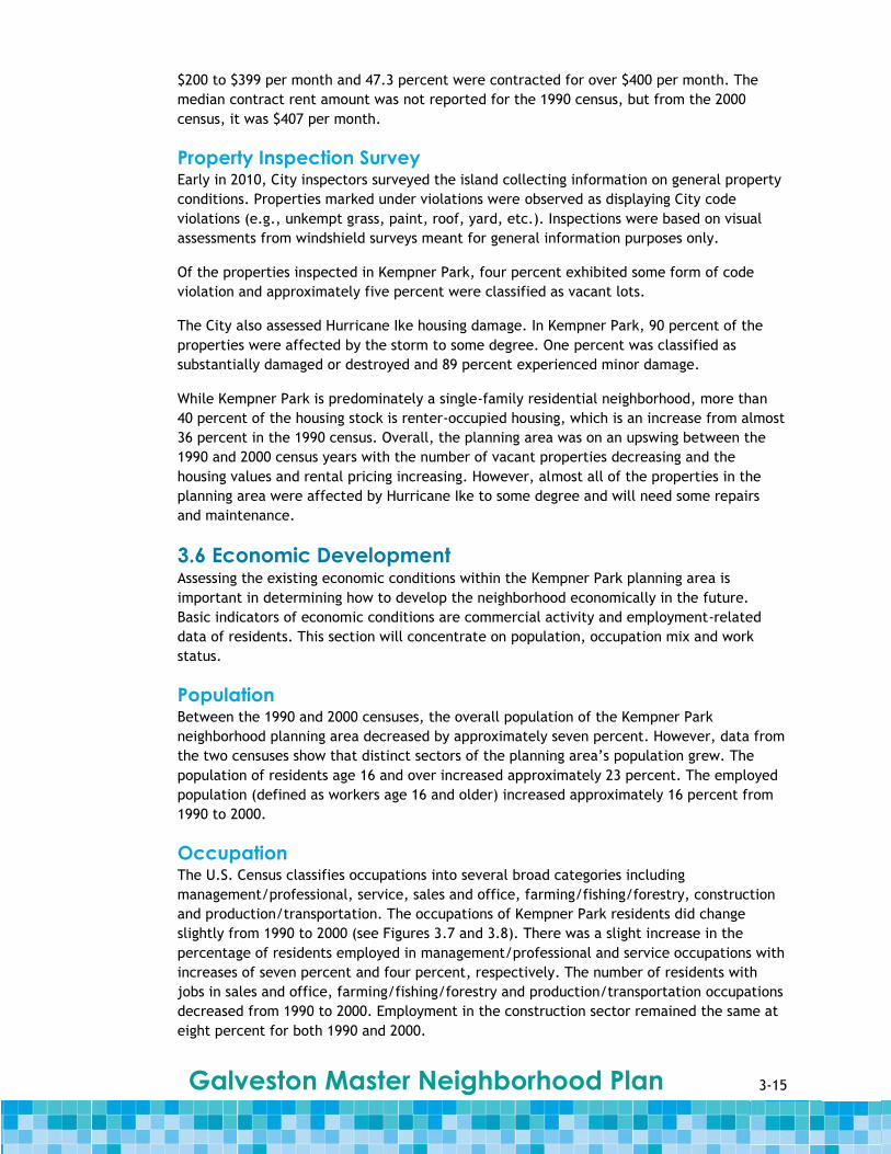
Occupation The U.S. Census classifies occupations into several broad categories including
management/professional, service, sales and office, farming/fishing/forestry, construction
and production/transportation. The occupations of Kempner Park residents did change
slightly from 1990 to 2000 (see Figures 3.7 and 3.8). There was a slight increase in the
percentage of residents employed in management/professional and service occupations with
increases of seven percent and four percent, respectively. The number of residents with
jobs in sales and office, farming/fishing/forestry and production/transportation occupations
decreased from 1990 to 2000. Employment in the construction sector remained the same at
eight percent for both 1990 and 2000.
Galveston Master Neighborhood Plan
3-16
Figure 3.7 Occupation, 1990 Figure 3.8 Occupation, 2000
Work Status Perhaps more telling than employment data by industry sector are work status data. The
1990 U.S. Census reported that 65 percent of the employable population (calculated as the
population age 16 and over) worked. However, only 63 percent of the employable
population worked in 2000 (see Table 3.10). This slight decrease could be attributed to the
small decline in the number of residents in the planning area, in particular those residents
of employable age.
Table 3.10 Work Status
Work Status 1990
Census
2000
Census
2010
Census
Worked in census year 65% 63%
Did not work in census year 35% 37%

3-17 Galveston Master Neighborhood Plan
Figure 3.9 Work Status, 2000
Figure 3.9 shows detailed data describing the work patterns of employed residents in the
2000 U.S. Census. The vast majority (79 percent) of those employed worked 35 or more
house per week, while approximately 21 percent of the population worked 34 hours or less
per week.[m10]
Development and Building As stated earlier, land use in the planning area is primarily single-family residential with a
small amount of multi-family residential, other residential, public space and commercial
land uses. Approximately 64 percent of the land zoned for commercial use is currently
developed with commercial land uses.
Overall, the economic conditions of the neighborhood planning area have remained
relatively unchanged between the two census years. There were slight decreases in the
total number of residents in the planning area and in the number of residents who were
employed. However, for those residents that were employed, they worked predominately
“white collar”, full-time jobs. In addition, there is room for growth in the commercial
sector, as approximately one-third of the land zoned for commercial use is undeveloped.
3.7 Transportation & Infrastructure
Transportation Travel through and within Kempner Park is mostly by way of personal automobile, transit
and bicycle.
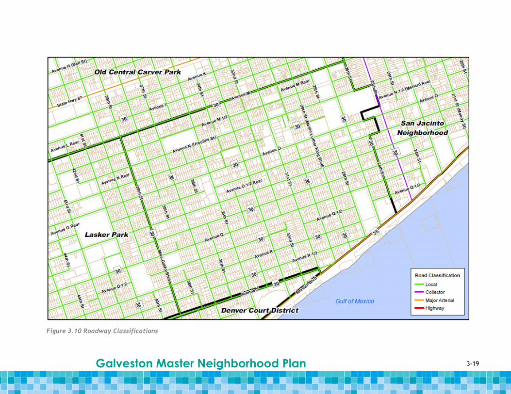
The roadways within the neighborhood planning area’s boundaries are shown in Figure 3.10.
Figure 3.10 also demonstrates how the roadways within the Kempner Park neighborhood
planning area are classified and what their speed limits are.
The planning area is highly accessible from the north, west and east, and can be accessed
from the south by Avenue S and Seawall Boulevard.
Galveston Master Neighborhood Plan
3-18
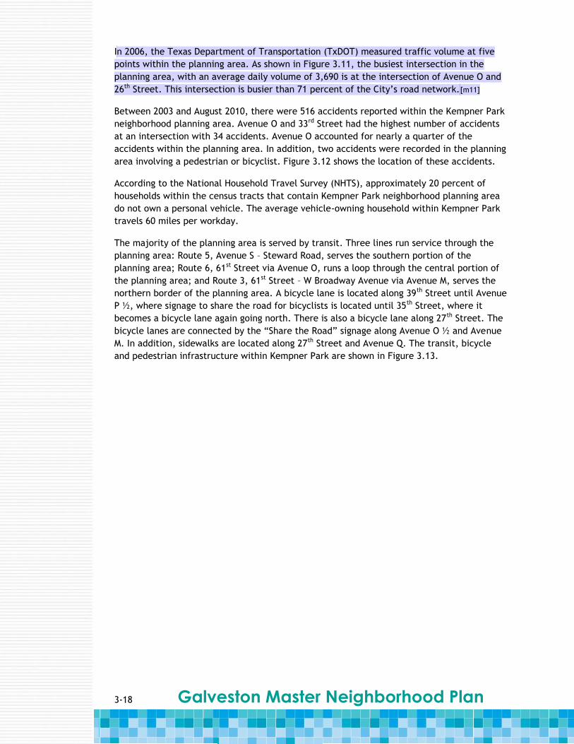
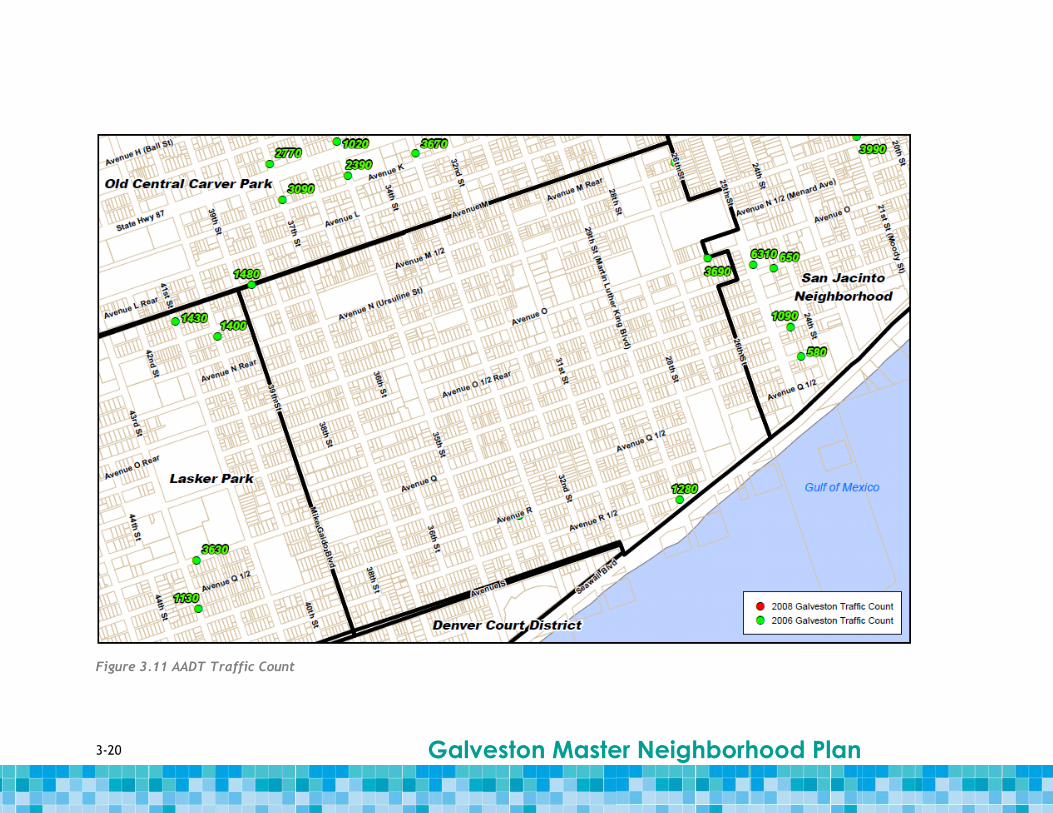
In 2006, the Texas Department of Transportation (TxDOT) measured traffic volume at five
points within the planning area. As shown in Figure 3.11, the busiest intersection in the
planning area, with an average daily volume of 3,690 is at the intersection of Avenue O and
26th Street. This intersection is busier than 71 percent of the City’s road network.[m11]
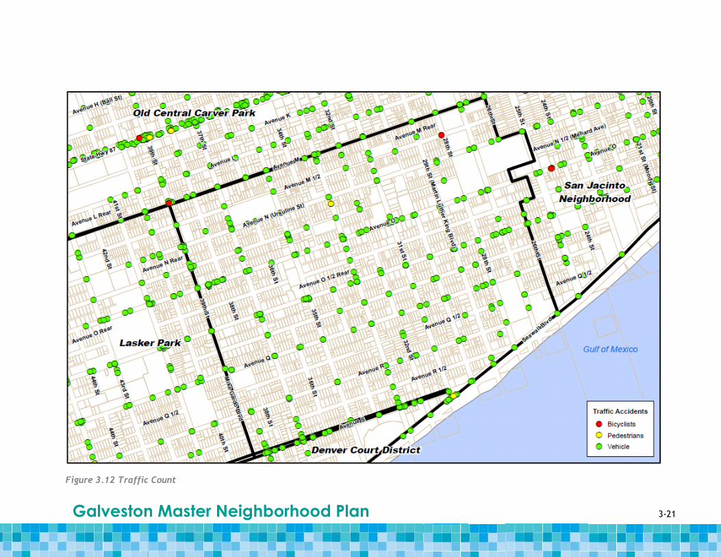
Between 2003 and August 2010, there were 516 accidents reported within the Kempner Park
neighborhood planning area. Avenue O and 33rd Street had the highest number of accidents
at an intersection with 34 accidents. Avenue O accounted for nearly a quarter of the
accidents within the planning area. In addition, two accidents were recorded in the planning
area involving a pedestrian or bicyclist. Figure 3.12 shows the location of these accidents.
According to the National Household Travel Survey (NHTS), approximately 20 percent of
households within the census tracts that contain Kempner Park neighborhood planning area
do not own a personal vehicle. The average vehicle-owning household within Kempner Park
travels 60 miles per workday.
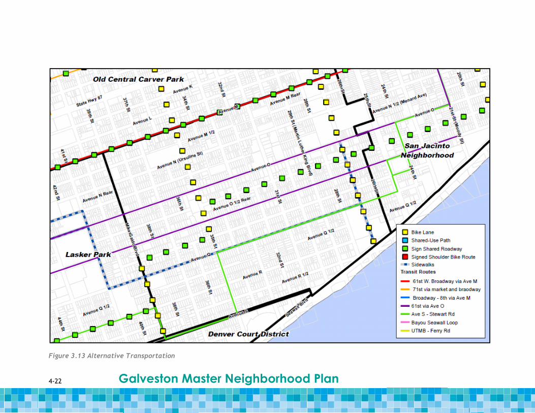
The majority of the planning area is served by transit. Three lines run service through the
planning area: Route 5, Avenue S – Steward Road, serves the southern portion of the
planning area; Route 6, 61st Street via Avenue O, runs a loop through the central portion of
the planning area; and Route 3, 61st Street – W Broadway Avenue via Avenue M, serves the
northern border of the planning area. A bicycle lane is located along 39th Street until Avenue
P ½, where signage to share the road for bicyclists is located until 35th Street, where it
becomes a bicycle lane again going north. There is also a bicycle lane along 27th Street. The
bicycle lanes are connected by the “Share the Road” signage along Avenue O ½ and Avenue
M. In addition, sidewalks are located along 27th Street and Avenue Q. The transit, bicycle
and pedestrian infrastructure within Kempner Park are shown in Figure 3.13.
3-19 Galveston Master Neighborhood Plan
Figure 3.10 Roadway Classifications
3-20 Galveston Master Neighborhood Plan
Figure 3.11 AADT Traffic Count
3-21 Galveston Master Neighborhood Plan
Figure 3.12 Traffic Count
4-22 Galveston Master Neighborhood Plan
Figure 3.13 Alternative Transportation
3-23 Galveston Master Neighborhood Plan
Infrastructure Although only a small portion of the Kempner Park neighborhood planning area is directly
adjacent to open waters, [m12]drainage problems are a major issue in the community.
Residents report the need for a more regular drainage maintenance schedule. Grass,
sediment, yard waste and trash are regularly reported in the drainage channels, reducing
capacity in the stormwater collection system and causing flooding at the following
intersections: 36th Street and Avenue R; 37th Street to 39th Street extending south from
Broadway Avenue; and 33rd Street at Avenues O and P. In addition, residents report that
paving projects on neighborhood planning area streets resulted in some stormwater inlets
and catch basins being paved over with asphalt. This area also has a number of bridge
blocks, which are prone to clogging and are difficult to maintain.
The stormwater, wastewater and water systems in Kempner Park all exhibit some level of
disrepair. There are many examples of localized stormwater drainage and flooding issues
across Galveston Island. In many instances, solutions to these problems will transcend
neighborhood planning area boundaries. A similar case holds for the City’s wastewater
collection and treatment system, which consists of five wastewater treatment facilities of
varying size and its water distribution system, which relies on water purchased from the
Gulf Coast Water Authority on the Texas mainland. For a citywide discussion of Galveston’s
stormwater, wastewater and water systems, see Appendix A.
3.8 Safety The Kempner Park neighborhood planning area is partially located in Police Zones 1 and 2,
the East Isle Community Mid-Town Community policing zones. The portion of the planning
area west of 35th Street is located in Zone 2, with the majority of the planning area in Zone
1, which covers the entire eastern portion of the island.
The closest emergency response center is Fire Station 1 located at Sealy and 25th Streets and
there is an emergency medical service center, Galveston Emergency Med Services located in
the planning area at Avenue Q and 26th Street.
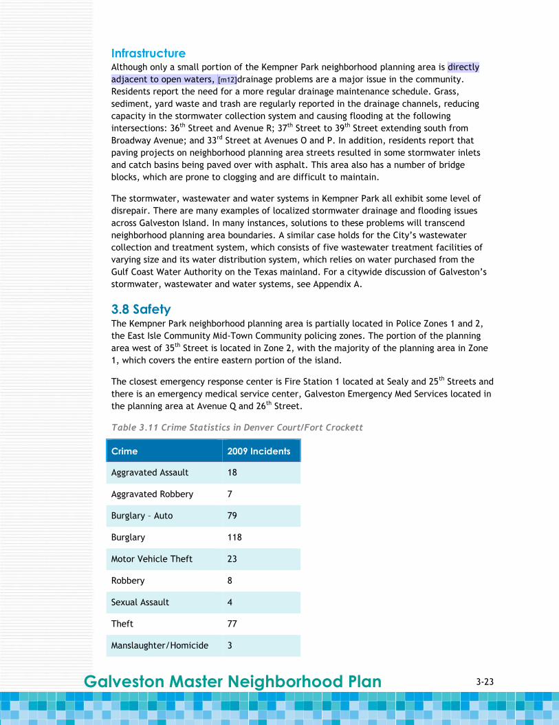
Table 3.11 Crime Statistics in Denver Court/Fort Crockett
Crime 2009 Incidents
Aggravated Assault 18
Aggravated Robbery 7
Burglary – Auto 79
Burglary 118
Motor Vehicle Theft 23
Robbery 8
Sexual Assault 4
Theft 77
Manslaughter/Homicide 3
4-24 Galveston Master Neighborhood Plan
Burglary and theft were the most reported crimes in 2009 in the planning area. As seen in
Table 3.11, there were a number of violent crimes, including three manslaughter/homicides
in 2009. Crime rates for burglary and violent crimes appear to be higher in the Kempner
Park area that for Galveston as a whole, underscoring the residents’ perception of the
neighborhood as being dangerous. While aware of the crime in the area, neighborhood
planning area residents feel that the Galveston Police Department is engaged and
responsive. Kempner Park residents identified the crime “hot spots” in the planning area at
35th Street and Avenue M N and at 28th Street and Avenue M. Goal #10 addresses this issue in
Section 4.
3-25 Galveston Master Neighborhood Plan
Blank page

4-1 Galveston Master Neighborhood Plan
Section 4 Goals, Opportunities &
Actions
4.1 Overview During public meetings, Kempner Park residents discussed and debated their priorities for
the neighborhood planning area’s future. The community indentified goals and selected
actions and opportunities for meeting the goals. This section describes the goals and
supporting opportunities and actions for Kempner Park that arose from the community
meetings.
Goal #1 Create a more “pedestrian friendly” neighborhood with the development of continuous
and contiguous sidewalks.
Kempner Park residents expressed that they want to construct continuous sidewalks
throughout the planning area. Currently, the exiting sidewalks are only present on some
streets and only on properties where the owner gave the City permission to build a
sidewalk. The main issue with constructing sidewalks is that the City does not own the right-
of-way next to the roads where sidewalks would be. These right-of-ways are private
property and since has often been neighborhood opposition in the past to constructing
sidewalks, the City is hesitant to develop another citywide sidewalk development policy.
The residents and the City would have to work together to develop a sidewalk development
policy.
If it were not possible to construct sidewalks along all streets in the planning area, they
would at least like to have continuous sidewalks in specific places or along specific routes.
For example, sidewalks would make sense along major roads (i.e., Avenues N, O, O ½, P and
Q and 31st and 35th Streets), near schools (i.e., Avenue N near 35th and 37th Streets and
Avenues N and O near 27th and 28th Streets) and as a path to the Seawall (i.e., 26th through
31st Streets). These paths should include sidewalks wide enough to accommodate at least
two people passing and should be constructed on both sides of the street.
Some issues that the residents of Kempner Park and the City of Galveston need to consider
when creating a more “pedestrian friendly” neighborhood include:
If constructing sidewalks along all streets in the planning area is not possible,
consider areas where having sidewalks would make the most sense, like areas where
children often walk to and from school, and near the Seawall where many tourists
walk.
The City does not own the right-of-way next to the roads where sidewalks could be
constructed.
Along the roads where residents would like to see sidewalks, but the City does not
own the right-of-way, residents will have to get a majority of the property owners
to agree to allow the City to construct a sidewalk on their property.

4-2 Galveston Master Neighborhood Plan
Opportunities & Actions
1.1 Residents consider conducting a survey of the planning area to identify areas where
there are no sidewalks.
1.1.1 The initial focus could be on major corridors, such as Avenues N, O, O ½, P
and Q, and 31st and 35th Streets; near schools on Avenue N near 35th and 37th
Streets, and Avenues N and O near 27th and 28th Streets; and paths to the
Seawall, including 26th through 31st Streets.
1.2 Residents consider conducting community outreach regarding the development of
sidewalks to gain the support of a majority of the residents, as they would have to
give their permission to have the City build sidewalks on their property.
1.2.1 Neighborhood group identifies and applies for matching grants for sidewalk
construction.
1.3 The City could look into developing a sidewalk development policy for the Kempner
Park.
1.4 The City could look into constructing sidewalks throughout the planning area along
those streets identified as needing and wanting sidewalks.
Goal #2 Improve street and alley conditions throughout the neighborhood planning area and
establish a regular maintenance schedule to maintain these roadways.
There is a need to have better maintenance of streets and alleys throughout the planning
area to assist in having fully functioning neighborhood streets and other corridors. Residents
expressed an interest in cleaning up and improving the alleyways, and using them as
additional pedestrian and bicycle paths in the planning area. To develop the alleys into
important connection points within the neighborhood planning area, the following issues
should be considered.
An alley can be thought of as a semi-private zone even though it might actually be a
public right-of-way.
Some portions of alleys are part of the residents’ property, thus the alley is
considered private property and the City must get permission from the resident to
improve that piece of land. Otherwise, residents would have to do the
improvements themselves.
Paving alleys with a pervious material (i.e., Portland Cement Concrete), it could
reduce the amount of runoff in the planning area.
Adding fences at the perimeter of the alley can emphasis the public and private
spaces and helps to screen unkempt yards.
Whether the alley is considered and extension of a resident’s property or it is legally
part of the property, they are commonly used spaces that residents can easily
monitor.
Throughout the City and in Kempner Park, parcels have been split up or additional
homes have been built at the back of properties which front onto the alley.
One of the issues that residents brought up with alleys included “dead wires” that no longer
work, which ruins the aesthetics of the alleys and can be hazardous. The residents have

4-3 Galveston Master Neighborhood Plan
tried to work with the City to solve this issue, but the City said they could not do anything
about them, because cable and utility companies privately own them.
Opportunities & Actions
2.1 Residents could identify alleyways that could potentially serve as pedestrian and
bicycle transportation corridors in the planning area.
2.1.1 Residents meet with property owners along the identified alleyways to
educate them on the neighborhood planning area goal of creating pedestrian
and bicycle path corridors throughout Kempner Park. As many of the alley
right-of-ways are privately owned, residents would need to get the buy-in of
the property owners adjacent to the identified alleyways.
2.2 Instead of multiple residents making customer service calls, residents could meet
with the cable and utility companies that own the “dead wires” that exist in many
of the alleys in the planning area and request the companies remove them. If
needed, the City could pressure the cable and utility companies to follow-through
on the requests.
2.3 The City considers holding a workshop with residents to identify alley improvement
preferences, including lighting, paving and resident cooperation for those alleys that
are part of the adjacent private property. Figure 4.1 shows examples of currently
existing alleyways. Figure 4.2 shows diagrams of existing and potential
improvements to alleyways to make them more inviting and pedestrian friendly.
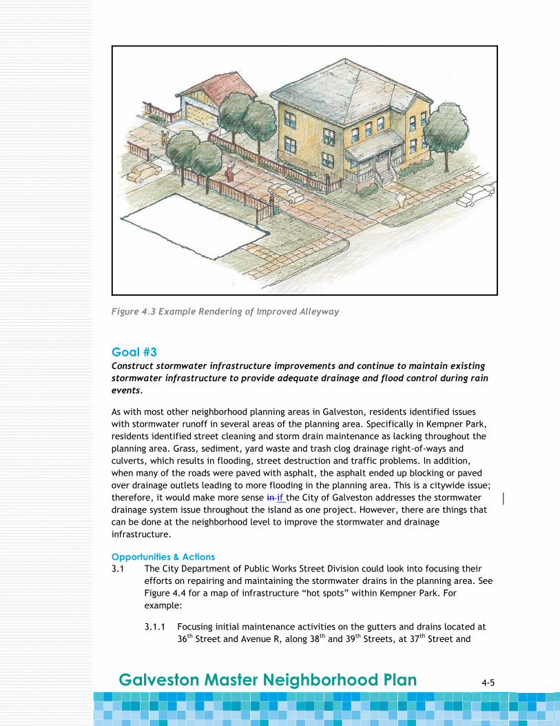
Figure 4.3 shows a rendering of what an improved alleyway might look like.
2.4 The City could look into investing in more bicycle officers in the planning area to
patrol the alleys and keep them safe. This action is also an action for Goal #9.
Figure 4.1 Existing Alleyway Conditions
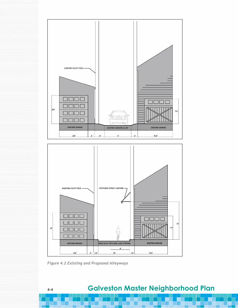
4-4 Galveston Master Neighborhood Plan
Figure 4.2 Existing and Proposed Alleyways
4-5 Galveston Master Neighborhood Plan
Figure 4.3 Example Rendering of Improved Alleyway
Goal #3 Construct stormwater infrastructure improvements and continue to maintain existing
stormwater infrastructure to provide adequate drainage and flood control during rain
events.
As with most other neighborhood planning areas in Galveston, residents identified issues
with stormwater runoff in several areas of the planning area. Specifically in Kempner Park,
residents identified street cleaning and storm drain maintenance as lacking throughout the
planning area. Grass, sediment, yard waste and trash clog drainage right-of-ways and
culverts, which results in flooding, street destruction and traffic problems. In addition,
when many of the roads were paved with asphalt, the asphalt ended up blocking or paved
over drainage outlets leading to more flooding in the planning area. This is a citywide issue;
therefore, it would make more sense in if the City of Galveston addresses the stormwater
drainage system issue throughout the island as one project. However, there are things that
can be done at the neighborhood level to improve the stormwater and drainage
infrastructure.
Opportunities & Actions
3.1 The City Department of Public Works Street Division could look into focusing their
efforts on repairing and maintaining the stormwater drains in the planning area. See
Figure 4.4 for a map of infrastructure “hot spots” within Kempner Park. For
example:
3.1.1 Focusing initial maintenance activities on the gutters and drains located at
36th Street and Avenue R, along 38th and 39th Streets, at 37th Street and

4-6 Galveston Master Neighborhood Plan
Broadway Street, near the schools on 32nd Street and at the intersections
along 33rd Street at Avenue O and Avenue P.
3.1.2 Identifying and repairing clogged stormwater drains.
3.1.3 Cleaning neighborhood planning area streets, including having a more
regular maintenance schedule and garbage pick-up.
3.1.4 Maintaining storm drains, including having a more regular maintenance
schedule.
3.1.5 Removing the asphalt that was used for pothole repairs from the drainage
right-of-ways at 30th Street and Avenue O ½.
3.1.6 Improving drainage infrastructure on Broadway Street to mitigate the
effects of water runoff into the planning area from the raising of the road.
3.2 The City considers better enforcement of the codes relating to people throwing
trash and debris into the gutters. In addition to better enforcement, the City looks
into citing and fining residents that are caught, which would motivate people to
keep the drainage right-of-ways clear.
3.3 Residents could organize regularly scheduled neighborhood street clean-up events to
pick up litter and other debris to prevent clogged culverts and keep the
neighborhood clean. This is also an action for Goal #8.

4-7 Galveston Master Neighborhood Plan
Figure 4.4 Map of Infrastructure "Hot Spots" in Kempner Park
4-8 Galveston Master Neighborhood Plan
Goal #4 Identify and improve major corridors with the addition of bicycle lanes, better signage,
lighting, landscaping, etc.[m13]
In addition to the regular maintenance that residents would like to see from the City, they
expressed an interest in improving the major corridors in the planning area. One of the
suggestions was to include bicycle lanes along the roadways, however many of the roads are
not large enough to accommodate both bicycle lanes and on-street parking. This is an issue,
since many residents do not have parking on their property and are required to park along
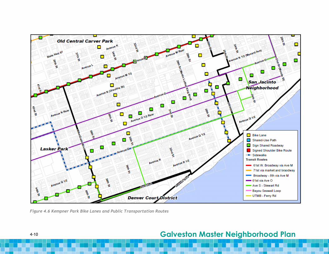
the streets. There are bike lane currently along 27th Street running north from Seawall
Boulevard, on 35th Street running north from Avenue P and on 39th Street between Avenue P
and Avenue S. To connect these bike lanes, there is “shared roadway” signage along Avenue
P between 35th and 39th Streets, along Avenue O ½ between 27th and 35th Streets and along
Avenue M on the northern boundary of the planning area. See Figure 4.6 for a map of bike
lanes and public transportation routes in Kempner Park.
In addition, residents would like to see streets throughout the planning area developed into
“complete streets” using the Complete Street concept. According to the Complete Streets
movement, complete streets are designed and operated to enable safe access for all users,
including pedestrians, bicyclists, motorists and public transportation users of all ages and
abilities (www.completestreets.org). Some common features include sidewalks, bike lines,
wide shoulders, crossing opportunities, refuge medians, bus shelters and crossings, special
bus lanes, raised crosswalks, audible pedestrian signals and sidewalk bulb-outs. There are
many benefits to developing Complete Streets including:
Improving safety for pedestrians with sidewalks, traffic-calming measures and
improvements along the street to make it more handicap-accessible and improving
safety for all users with raised medians, which decrease accidents.
Encouraging walking and bicycling, which leads to healthier residents.
Lowering transportation costs for families by providing more options in addition to
car trips.
Decreasing oil dependency.
Creating more livable communities where people feel safe and welcome on the
roadways.
Increasing air quality, which may lead to a decrease in asthma and other illnesses.
Opportunities & Actions
4.1 Residents could identify major corridors where they would like to see bicycle lanes,
better signage, lighting and landscaping.
4.2 Residents could look into installing more Kempner Park Neighborhood identification
signs along corridors to maintain community unity and to promote the neighborhood
as a destination.
4.3 The City could look into installing better street signage at intersections throughout
the planning area, including better stop signs at the intersections along 61st Street
at Avenue S, Avenue R and Avenue R ½.
4.4The City could look into adding bicycle lanes to larger roads in the planning area,
including 25th Street, 29th Street and 31st Street, and Avenue P and Avenue N.[m14]

4-9 Galveston Master Neighborhood Plan
4.5 Residents and the City consider working together to improve alleys and develop
them as bicycle paths for public use.
4.6 The City considers developing a Complete Streets development policy to formalize
the intent to plan, design and maintain streets so they are safe for all users of all
ages and abilities. See Figure 4.5 for an example rendering of what an improved
intersection in Kempner Park might look like at 31st Street and Avenue P. This
rendering shows the following Complete Streets elements:
Clearly visible stop signs
Bike lanes and designated on-street parking areas along Avenue P
Contiguous sidewalks
Minimal vegetation at corners to increase driver visibility when approaching the
intersection
Clearly marked pedestrian crossings
[m15]4.6.1 The City considers initially focusing on 25th, 39th and 31st Streets
with the installation of improved lighting, sidewalks, access, transportation,
landscaping, bicycle lanes and signage.
Figure 4. 5 Rendering of the Complete Street Concept at 31st Street and Avenue P Intersection
4-10 Galveston Master Neighborhood Plan
Figure 4.6 Kempner Park Bike Lanes and Public Transportation Routes
4-11 Galveston Master Neighborhood Plan
Goal #5 Attract middle-income grocery stores and other small-scale commercial establishments
to locate within the neighborhood planning area.
Currently, Kempner Park is a “food desert” with no full service grocery stores within its
boundaries. The residents would like to attract stores that offer healthier food options at
affordable prices. They want to develop more small-scale commercial corner stores that are
not considered “convenience stores”. If possible, they would prefer that these businesses be
locally owned. In addition to grocery stores, the residents would like to see the
development of more small businesses that fit the character of the neighborhood planning
area, including delis, cafes, hair salons, dry cleaners, etc. See Figure 3.4 in Section 3 for a
map showing the location of community, health and educational facilities, financial service
business, hotels and retail and food-related uses.
There are some issues to consider when trying to attract businesses to a neighborhood.
These include:
The City would have to develop appropriate tax incentives to attract the right kind
of business that the planning area needs.
Difficulties could arise if properties are not zoned for the types of businesses that
the residents would want.
The nation-wide economic downturn makes it difficult for people to get new small
business loans to start up their own business.
Attracting the wrong type of business could attract criminal activity.
Opportunities & Actions
5.1 Residents could look into creating an inventory of properties that could be used by
residents looking to start their own small-scale business and provide this information
to the City.
5.2 Residents meet with Galveston Economic Development Partnership to share
information on current conditions and opportunities.
5.3 Residents could look into disseminating information on small business development
with tip sheets, maps of available properties and contact information for programs
and agencies that support small businesses.
5.4 Residents and the City could look into providing support for small business
development by working with small business owners to find tax incentives and low-
interest loans specifically for small businesses. Other physical improvement
programs that encourage commercial development include:
5.4.1 Implementing redesigned streetscaping in commercial district. New
streetscapes designed with pedestrian infrastructure such as wide sidewalks,
trees and benches can serve as a catalyst for commercial redevelopment
and revitalization.
5.4.2 Provide commercial façade grants and design assistance. These progr4ams
can service as an incentive for small businesses to locate in commercial
areas of Kempner Park.
4-12 Galveston Master Neighborhood Plan
5.4.3 Offer municipal loan guarantees. This would help small businesses secure
loans from a risk-averse private lending market.
5.5 The City could look into trying to attract middle-income grocery stores, such as
South Harvest and other similar grocery stores, with tax incentives.
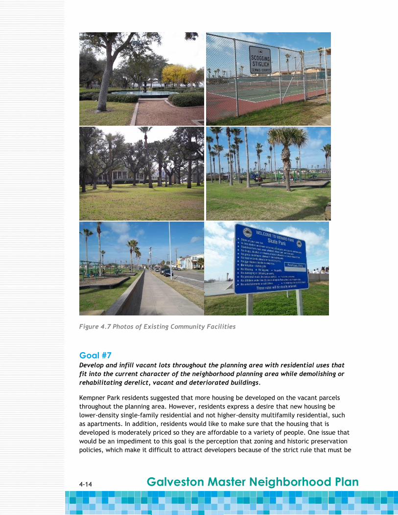
Goal #6 Capitalize on existing open spaces, community facilities and event spaces in Kempner
Park.
The residents of Kempner Park realize that they have a unique opportunity to improve and
take advantage of the community facilities that already existing in their community. These
spaces include the many public parks within the planning area like Kempner Park and
Menard Park, the Galveston Parks & Recreation Community Center on Seawall Boulevard and
27th Street, which includes an outdoor performance stage available to the public and
Courville Stadium at Avenue M and 28th Street. In addition to improving and preserving the
existing facilities, the residents would like to see the addition of other amenities, such as a
community swimming pool.
Courville Stadium is owned by the Galveston Independent School District (GISD) and is where
the Ball High School football team plays. In the recent past, there was a bond issue sent to
vote for the construction of a new stadium near the airport; however, the citizens of
Galveston did not approve the bond. The residents would like to make cosmetic changes to
the stadium, as it is still structurally sound[m16]. Currently, the City[m17] has plans underway
to make these cosmetic changes, but no specifics are known at this time. Since the stadium
only hosts a few games and other activities year around, there is an opportunity for
additional uses to be added to the schedule of stadium activities.
Opportunities & Actions
6.1 Residents consider identifying which open spaces, community facilities and event
spaces within the planning area that need to be improved.
6.2 Residents could look into using land use analyses to select sites for neighborhood
gardens to provide food for the residents. These gardens could be developed at one
of the existing public open spaces.
6.3 Residents and the City consider holding more neighborhood and City-sponsored
events at the existing community facilities.
6.4 The City could look into implementing nominal and affordable fees for use of
community facilities, which would help with the cost of maintenance.
6.5 The City considers developing a regular maintenance schedule for the community
facilities and open spaces (i.e., cutting grass, trimming trees, emptying garbage
bins, etc.).
6.6 The City considers improving existing community facilities and open spaces by
incorporating better landscaping, which would encourage more people to utilize the
spaces. In addition to providing better landscaping, there should be layout changes
made to some of the spaces to make them more user-friendly.

4-13 Galveston Master Neighborhood Plan
6.7 Residents meet with the City to discuss revitalizing and renovating the existing
outdoor performance stage at the community center. This performance stage has
been designated as a historical landmark.
6.8 The City and residents consider working together to prepare a revitalization plan for
Courville Stadium to allow for better utilization of the space. By involving the
neighbors and surrounding community members in the revitalization effort, this
would be a proactive way to give Kempner Park a positive image.
6.8.1 The City and residents consider working together to look for corporate
sponsors for Courville Stadium.
6.9 The City looks into studying the financial feasibility of building a swimming pool at
the existing community center. Not only would providing a new swimming pool in
Kempner Park help the residents to have better access, but it would relieve the
current congestion at the other community pools in the City.
4-14 Galveston Master Neighborhood Plan
Figure 4.7 Photos of Existing Community Facilities
Goal #7 Develop and infill vacant lots throughout the planning area with residential uses that
fit into the current character of the neighborhood planning area while demolishing or
rehabilitating derelict, vacant and deteriorated buildings.
Kempner Park residents suggested that more housing be developed on the vacant parcels
throughout the planning area. However, residents express a desire that new housing be
lower-density single-family residential and not higher-density multifamily residential, such
as apartments. In addition, residents would like to make sure that the housing that is
developed is moderately priced so they are affordable to a variety of people. One issue that
would be an impediment to this goal is the perception that zoning and historic preservation
policies, which make it difficult to attract developers because of the strict rule that must be

4-15 Galveston Master Neighborhood Plan
followed when building a residential structure. In addition, some lots would be required to
re-plat or there are already platting issues associated with the property.
The residents would like to see the new housing be developed in a similar manner to those
along the street it is being constructed to maintain the charm of the neighborhood.
There are some issues to consider when trying to develop vacant lots, including:
The vacant lots are private property, so the City and other residents would not be
able to do anything on the property without the permission of the owner.
Many owners could be hesitant to allow public uses on their property, as they could
be liable for any injuries that many occur.
If a property includes zoning that allows other uses besides single-family residential
uses, the City would not be able to deny the property owner their rights to build
what they would like on their own property.
There is an opportunity to develop the large number of vacant properties that currently
exist in Kempner Park. These vacant properties can lead to a variety of issues, including
squatters moving into the vacant buildings, which brings drugs and drug use problems into
the planning area. More code enforcement is needed for the owners of the vacant and
deteriorated buildings. In addition, there are issues with existing apartment complexes
falling into disrepair because owners are not on-site and are hard to contact.
The Kempner Park Neighborhood Association currently keeps a running list of properties that
it believes are in violation of City code. Members of the association bring this to the City’s
attention at the GAIN meetings. However, there is not enough clear communication as to
what extent the code enforcement resources and procedures are used in Kempner Park. The
City is still processing applications for rehabilitation assistance and continues to notify
property owners of code violations, but this information is not sufficiently well known
throughout the neighborhood planning area.
Opportunities & Actions
7.1 Residents should be encouraged to report violations directly to the City and
eventually to assigned inspectors. This is also an action for Goal #8.
7.2 Residents consider developing and implementing tenant and landlord education
programs that promote responsibility.
7.3 Residents consider identifying priority homes and areas where larger populations of
children and elderly residents live, play, go to school and work to target demolition
activities effectively.
7.4 In addition to residential uses, residents consider developing vacant property into
temporary or permanent community gardens or “pocket parks” for use by the
neighborhood.
7.5 The City could look into requiring property owners of reconstruction and
rehabilitation projects to be registered so that the contact information of the
owners/responsible parties is known.
7.6 The City could look into identifying derelict properties and develop a program with
a probation period for the owners to give them a timeframe of when repairs need to
4-16 Galveston Master Neighborhood Plan
be completed. In addition, the probation period could continue after the repairs to
make sure that maintenance is kept up with on the property.
7.7 The City considers reevaluating property maintenance inspection resources for
Kempner Park. Additional property maintenance inspectors would enforce property
maintenance codes and target specific areas of the planning area with proactive
inspections.
7.8 The City could look into developing guidelines and/or architectural vocabulary to
educate owners and developers interested in infilling vacant lots with residential
uses in Kempner Park.
7.9 The City Planning and Building Department could look into examining the zoning
code to allow for regulations that would help maintain the character of the
neighborhood, but would also make it easier to attract more developers.
Goal #8 Have better enforcement of littering laws to curb the amount of litter in the
neighborhood planning area.
At the neighborhood meetings, residents identified littering as a problem that diminishes
the character and environment of the planning area. Trash and debris that accumulates in
the neighborhood planning area contributes to a dilapidated appearance of the
neighborhood, which may discourage reinvestment and restoration. This trash and debris
come from a variety of sources including tourists near the Seawall, yard waste,
demolition/construction sites and household trash that does not get picked up by the City
on a regular basis.
Not only does littering contribute to a dilapidated neighborhood appearance, but it has
particularly bad implications when waste ends up in drainage ditches and culverts, which
obstructs the flow of stormwater and exacerbates the flooding in the neighborhood. Some
issues that should be considered include:
Residents believe that the biggest issue is having better enforcement of littering
laws.
A common habit among yard maintenance workers is to blow debris into the
drainage ditches, which is illegal but is rarely enforced.
It can be complicated to communicate with the City regarding code enforcement
issues and a simplified process should be developed.
Opportunities & Actions
8.1 Residents should be encouraged to take photos of waste, debris and other code
enforcement issues throughout the neighborhood and submit these to the City code
enforcement personnel.
8.1.1 Obtain contact information for the neighborhood’s assigned code
enforcement officer to report directly to them.
8.1.2 Elect one resident as a volunteer to compile a list of complaints and photos
to take directly to the assigned code enforcement officer.

4-17 Galveston Master Neighborhood Plan
8.2 Residents consider identifying areas in the planning area where littering is a
problem to determine where to place trashcans and post “No Littering” signage.
8.3 Residents could organize regularly-scheduled neighborhood street clean-up events
to pick up litter and other debris to prevent clogged culverts and keep the
neighborhood clean. This is also an action for Goal #3.
8.4 The City could look into better enforcing littering laws, including enforcing or
enacting additional fines for littering violations.
8.4.1 The City could looks into initially focusing on the areas near the Seawall where the
majority of tourists congregate, as they seem to be the people littering the most.
8.5 Residents could look into installing “No Littering” signs throughout the planning area
stating the consequences of littering to discourage people from throwing their trash
on the ground.
8.6 Residents consider working with the City to place more trash cans for public use
throughout the planning area to encourage people to throw away their trash
properly.
8.7 The City could look into maintaining a regular garbage pick-up schedule to keep
these trash cans from overflowing and causing more littering.
8.8 he City could look into setting up a 311 number for code enforcement complaints
and issues. The dispatcher for this number could forward the caller to the
appropriate city department.
Goal #9 Reduce crime and the perception of crime throughout the neighborhood planning area.
Crime was a major issue that was brought up often by residents. There is a perception that
many of the crimes take place in the alleys or in derelict and abandoned properties. The
police are aware of the problem areas, which include crime “hot spots” at 28th and 35th
Streets at Avenue M. An issue to consider is the perception of crime versus actual criminal
activity. Both of these lead to residents not feeling safe in their own neighborhood. In
addition, continued communication between the police department and the neighborhood
residents would assist the City in identifying areas that should be patrolled more often. This
would also lead to an increased feeling of safety by neighborhood residents when they see
more police patrolling the planning area.
Opportunities & Actions
9.1 Residents consider identifying areas in Kempner Park where criminal activity often
occurs or where they do not feel safe.
9.2 Residents could look into creating a sub-committee within the existing neighborhood
association to report specific crime and safety problem areas. The neighborhood
association could become responsible for communicating this information to the
police.
4-18 Galveston Master Neighborhood Plan
9.3 The City and residents consider working together to revitalize alleys so they are
used more often, which leads to a decrease in crime and an increase in the feelings
of safety for the residents (see Goal #2 for more information).
9.4 The City looks into installing closed circuit television (CCTV) in specific locations
where criminal activity often takes place.
9.5 The City looks into investing in more police officers to patrol the planning area and
specifically target alleys. This is also an action for Goal #2.
5-1 Galveston Master Neighborhood Plan
Section 5 Implementation
5.1 Overview The actions and opportunities in Section 4 cover a wide range of options, ranging from
immediate actions that can be taken by residents to long-term capital improvements that
must be spearheaded by the city with the support from outside agencies. Achieving the
goals through these actions requires a plan of attack. This section provides a suggested
approach to taking the steps toward achieving the goals of the residents of Kempner Park.
All of the recommended actions and opportunities in Section 4 have been reorganized in
table format. Their leading agent, the time frame for carrying out the action and the type
of action are identified. There is also a column for estimated costs, which the residents and
City will continue to fill in as actions are carried out and more accurate bids and estimates
can be collected. This section of the report constitutes a tool for all users of the
neighborhood plan to prioritize their next steps based on factors that provide a structure for
tackling the goals for the neighborhood.
In Kempner Park, the City is the leading agent for 33 actions. Residents are the leading
agent for 27 actions and both the City and residents are the leading agents for 10 actions.
To identify which actions correspond to the leading agent, see column “Who” in the
Implementation Table.
“Title” the table below and provide an id number
5-2 Galveston Master Neighborhood Plan
Action
Number What Who When Type of Action Cost
Goal #1: Create a more “pedestrian friendly” neighborhood with the development of
continuous and contiguous sidewalks.
1.1 Conduct a survey of
the planning area to
identify where
there are no
sidewalks.
Residents 0-6
months Research/Analy
sis
1.1.1 Initially focus on
major corridors,
near schools and
paths to the
seawall.
Residents 0-6
months Research/Analy
sis
1.2 Conduct community
outreach regarding
the development of
sidewalks to gain
the support of a
majority of the
residents.
Residents 0-6
months Communication
1.2.1 Neighborhood group
identifies and
applies for
matching grants for
sidewalk
construction.
Residents 0-6
months Coordination
1.3 Develop a sidewalk
development policy
for Kempner Park.
City 6-18
months Policy
1.4 Construct sidewalks
along those streets
identified by
residents as needing
and wanting
sidewalks.
City 6-18
months Physical
Investment
5-3 Galveston Master Neighborhood Plan
Action
Number
What Who When Type of Action Cost
Goal #2: Improve street and alley conditions throughout the neighborhood planning
area and establish a regular maintenance schedule to maintain these roadways.
2.1 Identify alleyways that could potentially serve as pedestrian and bicycle transportation corridors.
Residents 0-6 months
Research/ Analysis
2.1.1 Meet with property owners along identified alleyways to educate them on the goal of creating pedestrian and bicycle corridors in Kempner Park.
Residents 0-6 months
Coordination
2.2 Instead of multiple residents making customer service calls, meet with the cable and utility companies to remove “dead wires” from identified alleyways.
Residents 0-6 months
Communication
2.3 Hold a workshop with residents to identify alley improvement preferences, including lighting, paving and resident cooperation for those alleys that are part of the adjacent private property.
Residents & City
12-24 months
Physical Investment
2.4 Invest in more bicycle officers in the neighborhood to patrol the newly improved alleys (see Goal #9).
City 12-24 months
Policy

5-4 Galveston Master Neighborhood Plan
Action
Number
What Who When Type of Action Cost
Goal #3: Construct stormwater infrastructure improvements and continue to maintain existing stormwater infrastructure to provide adequate drainage and flood control
during rain events.
3.1 Focus efforts on
repairing and
maintaining
stormwater drains
in the neighborhood
planning area.
City 0-6
months
Physical
Maintenance
3.1.1 Focus initial
maintenance
activities on:
gutters and drains
located at 36th
Street and Avenue
R; along 38th and
39th Streets; at
37th and Broadway
Streets; near the
schools on 32nd
Street; at
intersections along
33rd Street at
Avenues O and P.
City 0-6
months
Physical
Maintenance
3.1.2 Identify and repair
clogged storm
drains.
City 0-6
months
Physical
Maintenance
3.1.3 Clean neighborhood
streets, including
having a more
regular
maintenance
schedule and
garbage pick-up.
City 0-6
months
Physical
Maintenance
3.1.4 Maintain storm
drains, including
having a more
City 0-6
months
Physical
Maintenance
5-5 Galveston Master Neighborhood Plan
regular
maintenance
schedule.
3.1.5 Remove asphalt
used for pothole
repairs from the
drainage right-of-
ways at 30th Street
and Avenue O ½.
City 0-6
months
Physical
Maintenance
3.1.6 Improve drainage
infrastructure on
Broadway Street to
mitigate the effects
of water runoff into
the neighborhood
from the raising of
the road.
City 12-24
months
Physical
Investment
3.2 Enforce codes
related to littering.
City 0-6
months
Regulation
3.3 Organize regularly-
scheduled
neighborhood street
clean-up event to
pick up litter and
other debris (see
Goal #8).
Residents 0-6
months
Event
Action
Number
What Who When Type of Action Cost
Goal #4: Identify and improve major corridors with the addition of bicycle lanes, better signage, lighting, landscaping, etc.
4.1 Identify major
corridors to add
bicycle lanes,
better signage,
lighting and
landscaping.
Residents 0-6
months
Research/Analy
sis
4.2 Install more Residents 0-6 Physical
5-6 Galveston Master Neighborhood Plan
Kempner Park
Neighborhood
identification signs
throughout the
neighborhood.
months Investment
4.3 Install better street
signage (i.e., stop
signs) at
intersections
throughout the
neighborhood,
including: 61st
Street at Avenues S,
R and R ½.
City 0-6
months
Physical
Investment
4.4 Add bicycle lanes to
larger roads in the
neighborhood,
including: 25th,
29th and 31st
Streets; Avenues N
and P.
City 6-18
months
Physical
Investment
4.5 Improve alleyways
and develop them
as bicycle paths for
public use (see Goal
#2).
Residents
& City
12-24
months
Physical
Investment
4.6 Develop a Complete
Streets
development policy
to formalize the
intent to plan,
design and maintain
streets so they are
safe for all users of
all ages and
abilities.
City 12-14
months
Policy
4.6.1 Focus intial efforts
on 25th, 39th and
31st Streets with
the installation of
improved lighting,
sidewalks, access,
transportation,
landscaping, bicycle
City 12-14
months
Physical
Investment
5-7 Galveston Master Neighborhood Plan
lanes and signage.
Action
Number
What Who When Type of Action Cost
Goal #5: Attract middle-income grocery stores and other small-scale commercial establishments to locate within the neighborhood.
5.1 Create an inventory
of properties that
could be used by
residents looking to
start their own
small-scale business
and provide
information to City.
Residents 0-6
months
Research/Analy
sis
5.2 Meet with
Galveston Economic
Development
Partnership to share
information on
current conditions
and opportunities.
Residents 0-6
months
Communication
5.3 Disseminate
information on
small business
development.
Residents 0-6
months
Communication
5.4 Support small
business
development by
providing assistance
on finding the
necessary
resources.
Residents
& City
0-6
months
Coordination
5.4.1 Implement
redesigned
streetscaping in
commercial district.
City 6-18
months
Physical
Investment
5.4.2 Provide commercial
façade grants and
design assistance.
City 6-18
months
Coordination

5-8 Galveston Master Neighborhood Plan
5.4.3 Offer municipal
loan guarantees.
City 6-18
months
Policy
5.5 Attract middle-
income grocery
stores using tax
incentives.
City 6-18
months
Policy
Action
Number
What Who When Type of Action Cost
Goal #6: Capitalize on existing open spaces, community facilities and event spaces in Kempner Park.
6.1 Identify which open
spaces, community
facilities and event
spaces need to be
improved.
Residents 0-6
months
Research/Analy
sis
6.2 Use land use
analyses to select
sites for
neighborhood
gardens in existing
public open spaces.
Residents 0-6
months
Coordination
6.3 Hold more
neighborhood and
City-sponsored
event at existing
community
facilities.
Residents
& City
0-6
months
Event
6.4 Implement nominal
and affordable fees
for use of
community
facilities to help
with maintenance
costs.
City 0-6
months
Policy
6.5 Develop a regular
maintenance
schedule for open
City 0-6
months
Physical
Maintenance
5-9 Galveston Master Neighborhood Plan
spaces, community
facilities and event
spaces.
6.6 Improve existing
open spaces and
community
facilities with
better landscaping.
City 6-18
months
Physical
Investment
6.7 Revitalize and
renovate the
existing outdoor
performance stage
at the community
center.
Residents
& City
6-18
months
Physical
Investment
6.8 Prepare a
revitalization plan
for Courville
Stadium.
Residents
& City
12-24
months
Program
Development/
Improvement
6.8.1 Look for corporate
sponsors for
Courville Stadium.
Residents
& City
12-24
months
Communication
6.9 Study the financial
feasibility of
building a swimming
pool at the existing
community center.
Residents
& City
12-24
months
Research/Analy
sis
Action
Number
What Who When Type of Action Cost
Goal #7: Develop and infill vacant lots throughout the neighborhood with residential
uses that fit into the current character of the neighborhood.
7.1 Encourage residents
to report violations
directly to the City
and eventually to
assigned inspectors.
Residents 0-6
months
Communication
5-10 Galveston Master Neighborhood Plan
7.2 Develop and
implement tenant
and landlord
education programs
that promote
responsibility.
Residents 0-6
months
Communication
7.3 Identify priority
homes and areas
where larger
populations of
children and elderly
residents live, play,
go to school and
work to target
demolition
activities.
Residents 0-6
months
Research/Analy
sis
7.4 Develop vacant
property into
temporary or
permanent
community gardens
or “pocket parks”
for use by the
neighborhood.
Residents 0-6
months
Coordination
7.5 Require property
owners of
reconstruction and
rehabilitation
projects to be
registered so that
the contact
information of the
owners/responsible
parties is known.
City 0-6
months
Program
Development/
Improvement
7.6 Identify derelict
properties and
develop a program
with a probation
period for the
owners to give
them a timeframe
in which they must
complete repairs
and maintain their
City 6-18
months
Program
Development/
Improvement
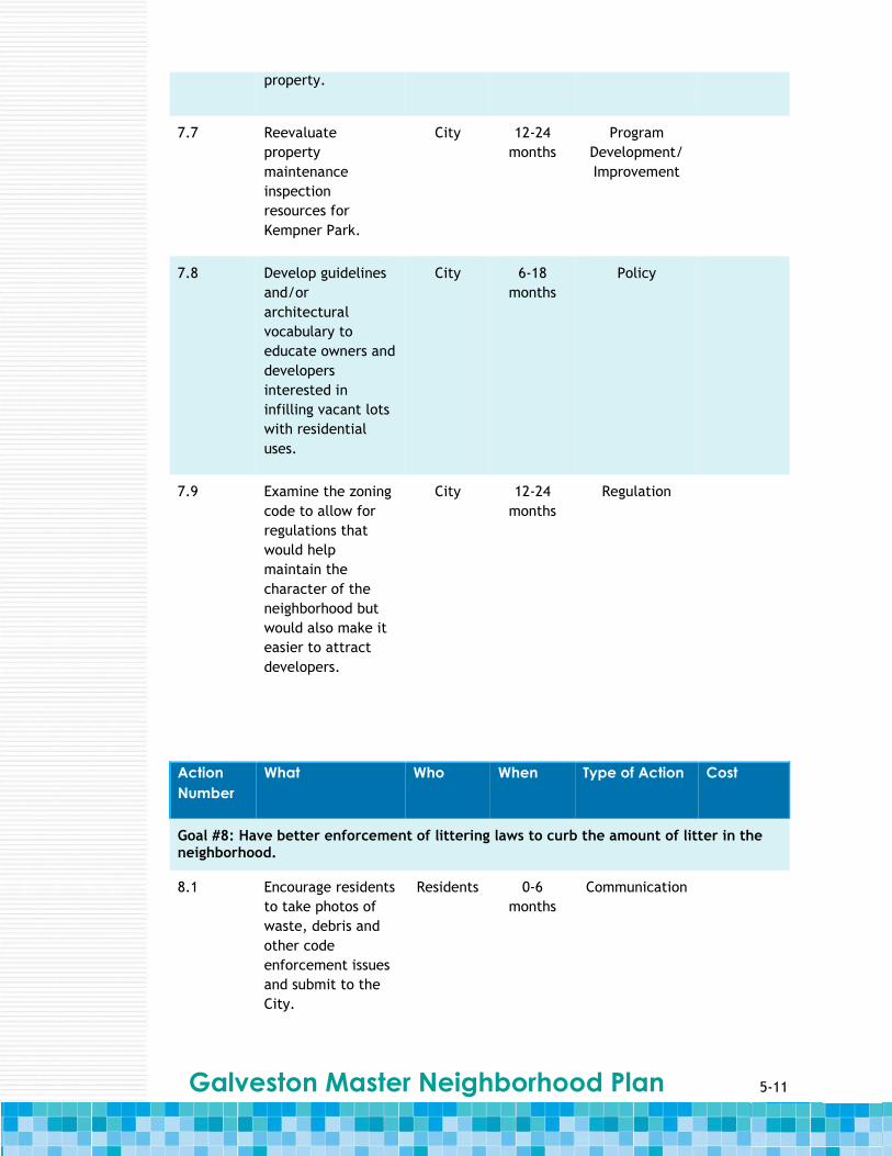
5-11 Galveston Master Neighborhood Plan
property.
7.7 Reevaluate
property
maintenance
inspection
resources for
Kempner Park.
City 12-24
months
Program
Development/
Improvement
7.8 Develop guidelines
and/or
architectural
vocabulary to
educate owners and
developers
interested in
infilling vacant lots
with residential
uses.
City 6-18
months
Policy
7.9 Examine the zoning
code to allow for
regulations that
would help
maintain the
character of the
neighborhood but
would also make it
easier to attract
developers.
City 12-24
months
Regulation
Action
Number
What Who When Type of Action Cost
Goal #8: Have better enforcement of littering laws to curb the amount of litter in the neighborhood.
8.1 Encourage residents
to take photos of
waste, debris and
other code
enforcement issues
and submit to the
City.
Residents 0-6
months
Communication
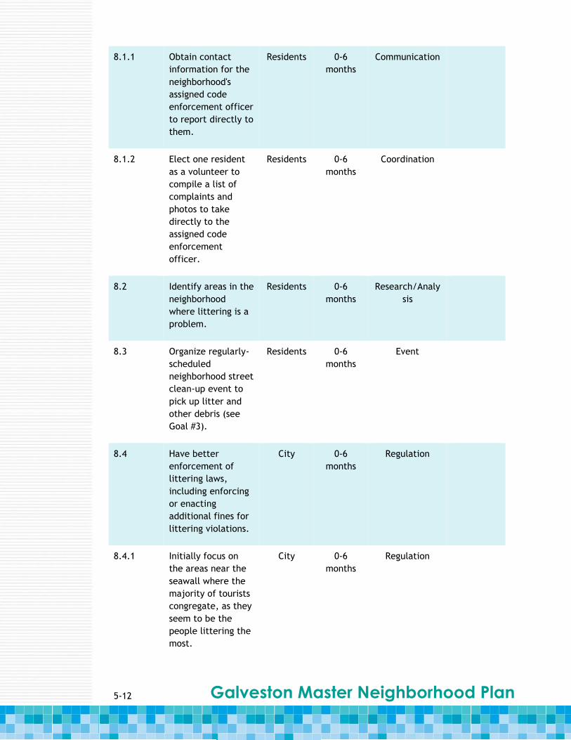
5-12 Galveston Master Neighborhood Plan
8.1.1 Obtain contact
information for the
neighborhood's
assigned code
enforcement officer
to report directly to
them.
Residents 0-6
months
Communication
8.1.2 Elect one resident
as a volunteer to
compile a list of
complaints and
photos to take
directly to the
assigned code
enforcement
officer.
Residents 0-6
months
Coordination
8.2 Identify areas in the
neighborhood
where littering is a
problem.
Residents 0-6
months
Research/Analy
sis
8.3 Organize regularly-
scheduled
neighborhood street
clean-up event to
pick up litter and
other debris (see
Goal #3).
Residents 0-6
months
Event
8.4 Have better
enforcement of
littering laws,
including enforcing
or enacting
additional fines for
littering violations.
City 0-6
months
Regulation
8.4.1 Initially focus on
the areas near the
seawall where the
majority of tourists
congregate, as they
seem to be the
people littering the
most.
City 0-6
months
Regulation

5-13 Galveston Master Neighborhood Plan
8.5 Install “No
Littering” signs
throughout the
neighborhood
planning area.
Residents 0-6
months
Physical
Investment
8.6 Place more
trashcans for public
use throughout the
neighborhood
planning area.
Residents
& City
0-6
months
Physical
Investment
8.7 Maintain a regular
garbage pick-up
schedule to keep
trashcans from
overflowing.
City 0-6
months
Physical
Maintenance
8.8 Set up a 311
number for code
enforcement
compliants and
issues.
City 6-18
months
Program
Development/
Improvement
Action
Number
What Who When Type of Action Cost
Goal #9: Reduce crime and the perception of crime throughout the neighborhood.
9.1 Identify areas
where criminal
activity often
occurs or where
residents do not
feel safe.
Residents 0-6
months
Research/Analy
sis
9.2 Create a sub-
committee within
the neighborhood
association to
report specific
crime and safety
problems areas.
Residents 0-6
months
Coordination

5-14 Galveston Master Neighborhood Plan
9.3 Revitalize alleys so
they are more often
to deter crime (also
see Goal #2).
Residents
& City
12-24
months
Physical
Investment
9.4 Install closed circuit
television (CCTV) in
specific locations
where criminal
activity often takes
place.
City 12-24
months
Physical
Investment
9.5 Invest in more
bicycle officers in
the neighborhood to
patrol the newly
improved alleys
(also see Goal #2).
City 12-24
months
Policy

Galveston Master Neighborhood Plan
APPENDICES

Galveston Master Neighborhood Plan
Blank page
A-1 Galveston Master Neighborhood Plan
Appendix A: City Wide
Infrastructure
Stormwater The Federal Emergency Management Agency (FEMA) uses flood maps to determine the flood
risk homeowners face, especially in coastal communities like Galveston. Prior to the
enactment of the National Flood Insurance Program (NFIP), homeowners had no mechanism
to protect themselves from the devastation of flooding, and in many parts of the United
States, unchecked development in the floodplain was exacerbating the flood risk. As part of
its administration of the NFIP, FEMA publishes flood hazard maps, called Flood Insurance
Rate Maps (FIRM). The purpose of a FIRM is to show the areas in a community that are
subject to flooding and the risk associated with these flood hazards. The map shown in
Figure A.1 consolidates the FIRMs that currently demarcate the Galveston neighborhood
planning areas. FEMA is scheduled to update the FIRMS in the near future.
Approximately 90 percent of Galveston is located in high risk flood areas as designated by
FEMA. As shown in Figure A.1, much of the island is designated as having a flood zone
classification of AE or VE. An AE or VE designated area has a one percent annual chance of
flooding and a 26 percent chance of flooding over the life of a 30-year home mortgage. In
communities that participate in the NFIP, mandatory flood insurance purchase requirements
apply to both of these zones. The remaining portions of Galveston, approximately 10
percent of the City, are designated as part of an X or 0.2 Percent flood zone classification. X
zone classifications have moderate to low risk of flooding. Within Galveston, areas
immediately adjacent to the Seawall – parts of the Denver Court/Fort Crockett, Kempner
Park, San Jacinto, and University Area neighborhoods - have X zone classifications. The 0.2
Percent designated areas are transition areas between the Seawall and high risk flood areas
and have a 0.2 percent annual chance of flooding.
FEMA designation provides one indication of flooding potential in a community, but equally
important is the operation and maintenance of the local stormwater collection and disposal
system. In 2003, a master drainage study was completed for the City of Galveston,
identifying the reaches, characteristics, and conditions of the existing major storm sewer
and drainage facilities. At the time of the 2003 study, a significant portion of the existing
drainage system was identified as undersized to meet current City stormwater collection
system design criteria. This evaluation was completed under the assumption that the
collection system is clean and free of debris. However, because of tidal effects and regular
winds, the collection system typically has significant levels of sand and silt, further
compromising its ability to convey stormwater away from flood prone areas.
The City essentially consists of two distinct systems - storm sewers and surface drainage.
Storm sewers primarily serve areas east of the Scholes International Airport behind the
Seawall. West of the airport the primary drainage system is open channels with culverts
and/or bridges. Based on reviews of old construction plans completed at the time of the
2003 study, much of the stormwater collection system was constructed using monolithic box
culverts and clay pipe inlet leads. Many of the inlet leads are less than 18 inches in
diameter, easily blocked by debris and silt. In addition, the system contains a significant
A-2 Galveston Master Neighborhood Plan
number of bridge blocks, which are shallow culverts that connect roadside gutters across
intersections, allowing water to pass under roadways where there are no storm sewers.
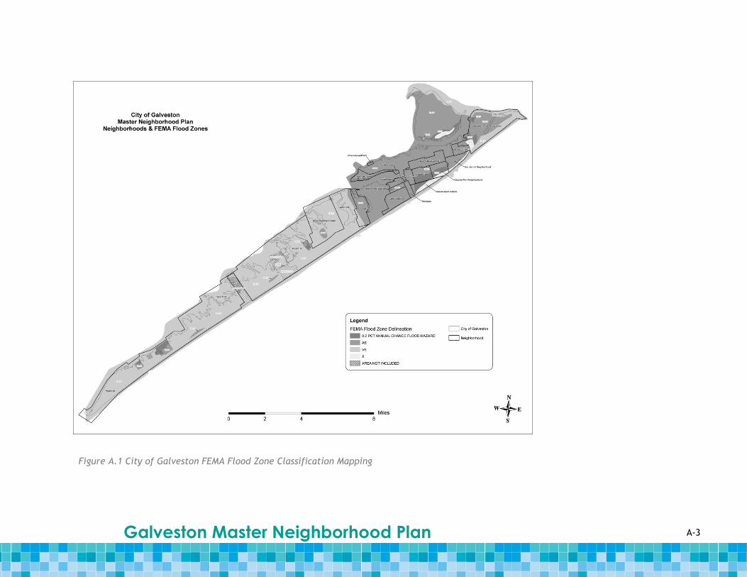
A-3 Galveston Master Neighborhood Plan
Figure A.1 City of Galveston FEMA Flood Zone Classification Mapping
A-4 Galveston Master Neighborhood Plan
Storm sewer maintenance operations primarily focus on street cleaning and removing debris
from storm drain inlets in the streets; limited resources are available for extensive
maintenance of underground and hard to access portions of the system. Sources of debris
include trash from the public, leaves, grass and other yard debris, and sand from beach
areas. Crews also typically inspect inlets before and after large City events such as Mardi
Gras to remove trash and debris and minimize system clogging. Crews also fix drainage
problems during storm events as conditions dictate. Prior to Hurricane Ike, street sweepers
were typically used along the Seawall and in the downtown area to minimize sand and silt
runoff into the stormwater collection system. However, the street sweepers were damaged
by Hurricane Ike and street sweeping is currently sporadic at best.
Due to limited maintenance of the underground system in the past, a large accumulation of
sand and debris has developed in the system. The City developed a new group within the
Sanitation District Recycling Group to tackle stormwater related issues more
comprehensively. The team cleans entire reaches of the drainage system starting with the
roadway gutters and continuing to the inlets, storm sewer leads and main storm sewer trunk
lines. While these efforts have helped to improve the functionality of the collection system
in some parts of the City, the progress has been slow due to staff shortages and competing
responsibilities.
While the state of the existing storm sewer system has been a concern of the City for some
time, the situation was made considerably worse due to the deposits left after the
floodwaters receded following Hurricane Ike. As a result of the storm, significant deposits
have been left in the storm sewer system, causing a reduction in the capacity of the pipes
and creating greater recurrences of flooding problems. According to the City’s 2010 Long-
Term Community Recovery Plan, City staff indicates that significant flooding (1-2 feet deep)
occurs more than once a year. This causes water to stand in the streets until it can exit
through the storm sewers or be soaked into the ground. This standing water creates a health
issue for residents and becomes a safety concern because emergency vehicles may not be
able to use certain roadways during these events.
Wastewater This wastewater discussion is based on a review of the City’s 2003 Comprehensive Plan. The
City of Galveston’s five wastewater treatment plants (WWTP) have a combined capacity of
approximately 15 million gallons per day (mgd). The WWTPs serve approximately 22,000
homes, approximately 88 percent of the City’s residents, and most commercial properties.
The WWTPs are dispersed throughout the city and are listed in Table A.1. Approximately
3,000 septic systems are currently in use in the City, primarily in the Bay Harbor, Indian
Beach, and Ostermeyer areas and in the vicinity of Harborside Drive from 52nd to 77th
Streets.
Approximately 75 percent of the residential wastewater in the City is treated at the Main
WWTP. The Main WWTP service area encompasses the area east of 57th Street and English
Bayou, and north of Offatts Bayou to 69th Street. This is the oldest part of the City. The
current service area is made up of two sectors, Downtown and the East End. The Main Plant
is currently overloaded and has no expansion capability.
The Airport WWTP service area is bound on the west by 57th Street, on the north by Offatts
Bayou to Spanish Grant and out to Teichman Road. The Airport WWTP itself is nearing
capacity and will require expansion to accommodate future development.
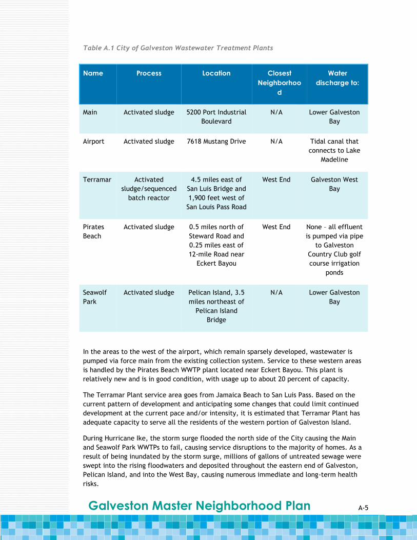
A-5 Galveston Master Neighborhood Plan
In the areas to the west of the airport, which remain sparsely developed, wastewater is
pumped via force main from the existing collection system. Service to these western areas
is handled by the Pirates Beach WWTP plant located near Eckert Bayou. This plant is
relatively new and is in good condition, with usage up to about 20 percent of capacity.
The Terramar Plant service area goes from Jamaica Beach to San Luis Pass. Based on the
current pattern of development and anticipating some changes that could limit continued
development at the current pace and/or intensity, it is estimated that Terramar Plant has
adequate capacity to serve all the residents of the western portion of Galveston Island.
During Hurricane Ike, the storm surge flooded the north side of the City causing the Main
and Seawolf Park WWTPs to fail, causing service disruptions to the majority of homes. As a
result of being inundated by the storm surge, millions of gallons of untreated sewage were
swept into the rising floodwaters and deposited throughout the eastern end of Galveston,
Pelican Island, and into the West Bay, causing numerous immediate and long-term health
risks.
Name Process Location Closest
Neighborhoo
d
Water
discharge to:
Main Activated sludge 5200 Port Industrial
Boulevard
N/A Lower Galveston
Bay
Airport Activated sludge 7618 Mustang Drive N/A Tidal canal that
connects to Lake
Madeline
Terramar Activated
sludge/sequenced
batch reactor
4.5 miles east of
San Luis Bridge and
1,900 feet west of
San Louis Pass Road
West End Galveston West
Bay
Pirates
Beach
Activated sludge 0.5 miles north of
Steward Road and
0.25 miles east of
12-mile Road near
Eckert Bayou
West End None – all effluent
is pumped via pipe
to Galveston
Country Club golf
course irrigation
ponds
Seawolf
Park
Activated sludge Pelican Island, 3.5
miles northeast of
Pelican Island
Bridge
N/A Lower Galveston
Bay
Table A.1 City of Galveston Wastewater Treatment Plants

A-6 Galveston Master Neighborhood Plan
Many reaches of the sanitary sewer collection system are also in need of replacement
and/or rehabilitation. There have been infiltration issues for a long time and the City has
commissioned studies to determine what pipes need rehabilitation and/or replacement.
These issues were exacerbated by the events associated with Hurricane Ike.
Many of the individual septic disposal systems in the City are failing, creating a potential
environmental problem. During rain events, residents have noted that raw sewage leaches
from their septic fields into their yards, roadside drainage ditches, Galveston Bay and the
Gulf of Mexico. This problem was worsened by Hurricane Ike and is a matter of the general
health and welfare of the residents and surrounding waters.
Water The City of Galveston purchases its drinking water from the Gulf Coast Water Authority
(GCWA). The potable water is brought to the City through two existing waterlines that run
above ground on an existing railroad bridge from the GCWA treatment facility in Texas City,
Texas. The first of these lines is a 30-inch transmission main with a capacity of
approximately 25 mgd. The second line is a 36-inch transmission main with a capacity of
approximately 35 mgd. A third, 30-inch transmission main with a capacity of approximately
25 mgd also connects to the City system via the West Bay and is underground near the
railroad bridge. It was constructed in 1894 and is not currently in service. The two working
transmission lines are both owned by the GCWA and the older, buried line is owned by the
City.
The City currently has approximately 32 million gallons of water stored on the island in both
ground and elevated tanks. Included in this is approximately 0.5 million gallons that is
stored in the existing ground level Jamaica Beach storage tanks. There are currently five
water pumping stations owned and operated by the City that provide the available water
pressure throughout the system. The stations are located at 30th Street, 59th Street, Scholes
Airport, Pirates Beach and Jamaica Beach. The existing water storage tanks and pumping
stations are located at relatively low elevations and subject to potential damage during
storm events.
Prior to Hurricane Ike, the City water usage during non-peak months was approximately 15
mgd and during peak months was approximately 25 mgd. In contrast, current non-peak
water usage is approximately 10 mgd. The existing system provides drinking water to the
entire City.
In the wake of Hurricane Ike, both City staff and residents have expressed concerns about
the long-term safety of the water system facilities, particularly related to Seawall
protection, storage capacity, and redundancy in the transmission system from the mainland.
The water distribution system on the eastern end of the City, consisting of the higher
density residential and commercial properties, is protected from storm damage along the
gulf side by the existing Seawall. However, it is not protected on the bay side. In addition,
the City’s western reaches, consisting of lower density, higher end residential properties,
remain unprotected on all sides against future storm events.
While the pressure in the system is not a source of concern, the amount of water stored on
the island and the amount of water stored at a high elevation are items of concern for the
community. Although the pump station mechanics did not fail, the City’s power supply to
the stations was cut off as a result of the storm. With limited storage capacity on the island,
the City was unable to maintain necessary pressures throughout the system.

A-7 Galveston Master Neighborhood Plan
There are also concerns about the two water transmission lines from the mainland. Their
current location on the existing railroad bridge makes them potentially susceptible to wind,
debris, flood, etc. during storm events. While neither of these lines was damaged during
Hurricane Ike, the bridge was affected by the storm and thus there are concerns about the
long-term safety of these transmission lines.
Increasing protection of these existing highly valuable assets and upgrading the
infrastructure are central to the overall viability of the recovery of the City and could
mitigate extensive damage from future storm events. In order for a full recovery to
continue, the City must ensure that greater water service dependability and adequate water
pressures are available throughout the island at all times.
A-8 Galveston Master Neighborhood Plan