Embed Size (px)
Citation preview

MEMORANDUM
TO: PLANNING COMMISSION
FROM: TERESA McCLISH, COMMUNITY DEVELOPMENT DIRECTOR
BY: ~1f_ KELLY HEFFERNON, ASSOCIATE PLANNER
SUBJECT: CONSIDERATION OF DEVELOPMENT CODE AMENDMENT 17-001, VESTING TENTATIVE TRACT MAP 16-001 (TRACT 3079) AND A DRAFT MITIGATED NEGATIVE DECLARATION FOR A 7-LOT RESIDENTIAL SUBDIVISON; LOCATION- RODEO DRIVE AND GRACE LANE; APPLICANT- KIRBY GORDON; REPRESENTATIVE -JEFFREY EMRICK
DATE: MARCH 21, 2017
RECOMMENDATION: It is recommended the Planning Commission review and adopt the attached Resolution recommending that the City Council adopt an Ordinance approving Development Code Amendment 17-001, and adopt a Resolution adopting a Mitigated Negative Declaration and approving Vesting Tentative Tract Map 16-001.
IMPACT ON FINANCIAL AND PERSONNEL RESOURCES: None.
BACKGROUND: The 7.52-acre project site is located within the Royal Oaks Planned Development (PD 1.3) as shown in the map below. The property is currently vacant, and bounded by Rodeo Drive to the south and Grace Lane to the east.
View of project site from Rodeo Drive, looking west

PLANNING COMMISSION CONSIDERATION OF DCA 17-001 & VTTM 16-001 MARCH 21, 2017 PAGE2
Surrounding land uses include St. Patrick's school and low-medium density residential development within the Rancho Grande Planned Development (PD 1.2) to the west, low-medium density residential development in the Grace Lane subdivision to the north, open space and low-medium density residential development to the east, and vacant multi-family residential property owned by the County of San Luis Obispo to the south. Site topography ranges from a previously graded flat terrace area to steeply sloped banks. The site has not been maintained for an extended period of time, and existing vegetation consists primarily of weeds, grasses and shrubs. A tree inventory was conducted as part of a previous Pre-Application for this property by Pleinaire Design Group, which identified a total of sixteen (16) trees in varying degrees of health. Trees identified include Monterey Pine, London Plane, Eucalyptus, and Coast Live Oak (see Attachment 1 for tree inventory).
Arroyo Grande Municipal Code Section 16.44.010 provides for the Planned development (PD) district, which only applies to existing planned developments of record and listed in that Section. The 7.52-acre project site is located within the Royal Oaks Planned Development, and is listed in Section 16.44.010 as (PD 1.3), which was established in 1987 by Ordinance 355 C.S. (Attachment 2) and was later amended by the following Ordinances:
Ordinance No. 356
358 384 406
418 430
449
553
Title Amending 355 C.S. Re: Lot A and Via La Barranca Drainage System in Royal Oaks Estates Amending Lot A, and Lots 34-40 Lot Lines in Royal Oaks Estates Sidewalk Construction in Royal Oaks Subdivision Amending Ordinance No. 355 C.S. Royal Oaks Estates to Modify Exhibit "A" Amending Ord. No. 355 C.S. Royal Oaks Estates Amending Ordinance 355 C.S. by Allowing a Church on Lot B, Royal Oaks Amending Ordinance No. 355 C.S. "Royal Oaks Estates" by Allowing a Church on Lot 184 and Approving and Adopting Specific Development Plan 91-05 Amending Ordinance No. 355 C.S. "Royal Oaks Estates" To Increase The Maximum Allowed Density Within The Planned Development, And Amending The Zoning Map To Designate The Subject Property As Residential Rural (RR) With A Planned Development Overlay; Development Code Amendment 02-001, Applied For By Don McHaney, For Property Located On Grace Lane (Lot 182 and portion of Lot B of Tract 1390)
The subject property is identified as Lot 184. Lots "B", 182 and 184 were zoned specifically for "single family estate homes" allowing only one dwelling unit per lot. The 2001 General Plan changed the land use of these lots from PD 1.3 residential estate lots to Single Family Residential Low Density with a Planned Development overlay (SFR-LD-
PLANNING COMMISSION CONSIDERATION OF DCA 17-001 & VTTM 16-001 MARCH 21, 2017 PAGE3
PD), allowing up to one dwelling unit per acre. The 2001 Land Use Element of the General Plan reflects the fact that the City is reaching "buildout", with relatively limited remaining vacant, undeveloped land available for continued single family residential subdivision. Policy LU2-2 of the Land Use Element provides justification for the increase in density for various properties within the City, including the subject property, as follows:
"LU2-2: Accommodate the development of Residential Hillside cluster development and large lot conventional subdivisions in appropriate areas, classified as Single Family Residential Low Density (SFR-LD).
LU2-2.2: Accommodate the development of large lot conventional subdivisions (1du/1ac) within appropriate SFR-LD areas (zoned City RR)."
Tract 2236 (the "Grace Lane" residential subdivision) was approved on January 13, 2004, which allowed nineteen (19) residential lots to be constructed on Lots 182 and a portion of "B'', leaving one residential unit to be constructed on Lot 184. Lot 184 remains the only undeveloped parcel within PD 1.3.
Previous Pre-Application The Planning Commission considered Pre-Application 14-006 on March 3, 2015 for a clustered subdivision of the subject 7 .52-acre property into eighteen (18) residential lots with an average of 4,000 square feet in size (see Attachment 3 for meeting minutes). The remaining land area was to be used as common open space. The applicant revised the project based on Planning Commission comments to reduce the number of lots from eighteen (18) to thirteen (13), providing for a less dense development and larger lot sizes. The City Council considered the redesign on April 28, 2015 (see Attachment 4 for meeting minutes). Because the project would require a General Plan Amendment to increase density beyond what was evaluated in the General Plan Program EIR, especially during an exceptional drought condition, the project was not well received and the applicant did not pursue a formal application. The consensus from the City Council was that a seven (7) lot subdivision, consistent with the General Plan Land Use Map, would be supported.
Staff Advisory Committee: The Staff Advisory Committee (SAC) reviewed the proposed project on July 27, 2016. Discussion focused on building envelopes, emergency access and adequate turnaround, slope analysis, perimeter fencing, design guidelines, maintenance of the drainage basins, water availability, and sight distance at the access driveway. The SAC discouraged a previous proposal of providing access to Lot 5 from Grace Lane because of the amount of grading required, and to limit the number of access points from Grace Lane given its collector street designation. Overall, the SAC was in support of the project.
Architectural Review Committee: The Architectural Review Committee (ARC) considered the project on March 6, 2017 and recommended approval of the project Design Guidelines with the following amendments:

PLANNING COMMISSION CONSIDERATION OF DCA 17-001 & VTTM 16-001 MARCH 21, 2017 PAGE4
• Require landscaping along the Grace Lane and Rodeo Drive frontages that utilizes native or Mediterranean plant materials to create an enhanced natural look. Lots 1, 5, 6, and 7 would be subject to this requirement through the Architectural Review process. The soil will need to be amended appropriately to encourage successful plant establishment.
• Homeowners are required to eradicate Pampas Grass on their property. A note to this effect shall be shown on individual landscape and irrigation plans.
• Native coast live oak trees are to be retained on undisturbed slopes regardless of size.
• Homes constructed on Lots 5-7 shall have detailed articulation and/or additional screening on the rear building elevation facing the street to improve the aesthetic views from Grace Lane and Rodeo Drive.
These recommendations have been incorporated into the project Design Guidelines.
ANALYSIS OF ISSUES:
Project Description The proposed project involves amending the Arroyo Grande Municipal Code to allow additional residential units within Planned Development 1.3 and subdividing a 7.52-acre property into seven (7) residential lots ranging in size from 0.58 to 1.32 acres with a 0.28-acre offer of dedication for roadway purposes. The intent of the dedication is to provide for the potential realignment of Grace Lane as one of the alternatives associated with the Brisco Road interchange project. The City will accept the offer of dedication if the City decides to implement the Grace Lane realignment.
Access to the site is via a cul-de-sac (Rodeo Court) from Rodeo Drive. Rodeo Court is designed to meet City standards (Engineering Standards 7010 and 7020 for a local road and cul-de-sac Type I) for a public road. Public improvements for the tract, including installation of utilities, drainage basins and the access road will require the removal of several trees including one (1) eucalyptus and two (2) sycamore trees. Development of individual lots will likely require additional tree removal that will be considered through the Architectural Review and building permit processes. The property is located on a knoll and is visible from US Highway 101 and residential development to the east. The area of the project proposed for development has been previously graded and has lost its natural appearance to some degree.
Development Code Amendment Planned development (PD) districts were established to be more flexible than those contained elsewhere in the Development Code. The purpose of establishing these districts was to grant or require diversification in the location of structures and other site elements which were believed to be appropriately compatible, while ensuring adequate standards relating to the public health, safety, welfare, comfort and convenience. The

PLANNING COMMISSION CONSIDERATION OF DCA 17-001 & VTTM 16-001 MARCH 21, 2017 PAGES
City does not intend to create any new PD districts. Amending an existing PD requires a Development Code Amendment.
The proposed Development Code Amendment would amend Ordinance 355 C.S. to allow additional density on Lot 184 consistent with the General Plan land use designation of Single Family Residential Low Density (SFR-LD). The PD 1.3 zoning for this property will not change since all properties within PD 1.3 have this zoning designation. The zoning district that appears most consistent with the SFR-LD land use designation would be Residential Rural (RR), which provides for one dwelling unit per acre as proposed. However, due to the topographical constraints of the property and existing graded pads, the site development standards of the Single-Family Residential (SFR) zoning district are more appropriate. Note that because this is a Planned Development, which is similar to a Specific Plan, setbacks and other development standards do not have to reflect an existing zoning district within the City and can be uniquely established through the entitlement process. The Design Guidelines for the subdivision indicate setbacks that reflect the SFR zoning district as follows:
Setback Table I Setbacks: I Lot 1 I Lot2 I Lot 3 I Lot4 I Lots I Lot 6 I Lot7 Front 20' 20' 20' 1 O' 20' 20' 20' Sides 1 O' 1 O' 1 O' 10' 1 O' 10' 10' Rear Limited to Limited to Limited to Limited to Limited to Limited to Limited
the the the the the the to the building build ing building building building building building envelope envelope envelope envelope envelope envelope envelope
Drainage The soil at this location is not conducive to good percolation and the slopes are relatively steep for portions of the site. Low Impact Development (LID) standards to retain stormwater runoff for a project of this size require LID measures to be implemented. The project proposes two (2) drainage basins along the Rodeo Drive frontage and individual lots will be required to meet LID requirements through the building permit process. Project conditions of approval include full compliance with State Water Board stormwater requirements. The drainage basins will be maintained through an approved cooperative maintenance agreement between all lot owners.
Affordable Housing As conditioned, the applicant will pay an affordable housing in-lieu fee to satisfy the City's affordable housing requirements.
Slope Analysis A slope analysis was prepared for the project that provided the following information for each lot:
I

PLANNING COMMISSION CONSIDERATION OF DCA 17-001 & VTTM 16-001 MARCH 21, 2017 PAGES
Slope Lot1 Lot2 Lot 3 Lot4 (36,388 (37,479 (37,383 (33,354 sq. ft.) sq. ft.) sq. ft.) sq. ft.)
0-7% 42% 18% 44% 64% 7-15% 5% 0% 0% 2% 15-25% 0% 0% 0% 0% >25% 53% 82% 56% 34% Avg. Slope 36% 52% 37% 24%
Lots Lot6 Lot7 (57,602 (55,173 (25,180 sq. ft.) sq. ft.) sq. ft.) 46% 24% 60% 2% 9% 5% 0% 0% 0% 52% 67% 35%
34% 40% 25%
Per Table Table16.20.050-A of the Development Code, lots located on 7-15% slopes have a minimum size requirement of 10,000 square feet while lots located on 15-25% slopes have a minimum size requirement of 20,000 square feet. Slopes over 25% are to be preserved for open space. All of the lots have some percentage of slopes greater than 25% and all are over the 20,000 square foot requirement. The majority of development will occur on slopes between 0% and 7% where the site was previously graded, with the exception of Lots 1 and 2 which have a higher percentage of steeper slopes. It is anticipated that development of these two lots will cut into the existing slope with the back wall of the home serving as a retaining wall.
Project Landscaping A landscape and irrigation plan consistent with the State Model Water Efficiency Landscape Ordinance (MWELO) is required as a condition of approval for each lot prior to issuance of building permit. The ARC recommended that project frontage landscaping along Rodeo Drive and Grace Lane should be required as part of the subdivision entitlement rather than leaving it in its current condition (see Attachment 5 for site photos).
Design Guidelines The development plan creates seven (7) custom residential lots arranged around a culde-sac that utilizes the previously graded upper plateau area. Although a Planned Unit Development application is not required to accompany the proposed subdivision, Design Guidelines have been prepared to ensure that future development of the lots complement the surrounding development to the west within the Rancho Grande Planned Development, and to the north within the Grace Lane subdivision. The proposed Design Guidelines are included as Exhibit C of the City Council Resolution approving the tract map.
The Design Guidelines include information and guidance on design goals (setting, concept, intent, application and common facilities), site design (drainage, grading, building envelopes and building height), building design (style and character, driveway and garages, architectural features, articulation, entries, garage doors, exterior materials, exterior colors, roof materials, roof drainage, trash containers, mechanical equipment, satellite dishes and antennas, fire sprinklers, lighting, secondary units, water

PLANNING COMMISSION CONSIDERATION OF DCA 17-001 & VTTM 16-001 MARCH 21, 2017 PAGE7
conservation and energy efficiency), and site improvements. (hardscape, landscaping and fencing).
The Design Guidelines do not designate any particular architectural style, although any style proposed should be consistent in detail. Specifically, the Design Guidelines state that architectural styles shall be low profile and may include Farmhouse, Craftsman, Cottage, Bungalow, Prairie and Spanish Eclectic. Unacceptable styles include Victorian, Tudor, Colonial, and Mid Century Modern designs, mainly due to the high roof pitches or flat two-story wall planes.
As conditioned, development plans for individual lots require an approved Architectural Review permit and Architectural Review Committee consideration to ensure adherence with the Design Guidelines.
Fencing Proposed tract perimeter fencing is 4-foot tall split rail with no climb mesh wire similar to fencing found in Rancho Grande. Privacy fencing will be regulated per Development Code Section 16.48.070 ("fences, walls and hedges") and can be of various forms of wood, vinyl, ornamental welded metal, or masonry.
ADVANTAGES: The proposed project will subdivide a vacant property into residential lots at a low density consistent with the 2001 General Plan. The project will provide the community with residential infill and seven (7) new home sites for housing opportunities.
DISADVANTAGES: The proposed project produces potential aesthetic impacts with the introduction of hillside residences.
ENVIRONMENTAL REVIEW: In accordance with the California Environmental Quality Act (CEQA) Guidelines, a Mitigated Negative Declaration has been prepared for this project (Attachment 6) . Mitigation is required for aesthetics, biological resources, greenhouse gas emissions, cultural resources, air quality, hydrology/water quality, and noise. Mitigation measures are included in the attached Resolution as conditions of approval.
Referrals were sent to agencies that may be impacted by the project or that may have comments, including: the County of San Luis Obispo that owns property across Rodeo Drive zoned Multi-Family and Public Facility; Caltrans that has the Brisco Road interchange within close proximity; and Heal-SLO Healthy Communities Work Group, which provides responses to planning staff from a healthy community's perspective on proposed land development projects, ordinances, general plan amendments, and special projects. The City received comments from Heal-SLO, which are included as Attachment 7. Caltrans indicated that they did not have any comments and no response was received from the County Planning and Building Department.

PLANNING COMMISSION CONSIDERATION OF DCA 17-001 & VTTM 16-001 MARCH 21, 2017 PAGES
PUBLIC NOTIFICATION AND COMMENTS: A notice of public hearing was mailed to all property owners within 300' of the project site, and expanded to include adjacent neighborhoods (see Attachment 8 for map of properties included in the noticing). A notice was also published in The Tribune and posted at City Hall and on the City's website on Friday, March 10, 2017. The Agenda was posted at City Hall and on the City's website in accordance with Government Code Section 54954.2. At the time of report publication, no comments have been received.
Attachments: 1. Tree Inventory for the Project Site 2. Ordinance 355 C.S. 3. March 3, 2015 Planning Commission Meeting Minutes 4. April 28 , 2015 City Council Meeting Minutes 5. Site Photos 6. Initial Study/Draft Mitigated Negative Declaration 7. Referral Response Letter from Heal-SLO 8. Area Noticing Map

RESOLUTION NO.
A RESOLUTION OF THE PLANNING COMMISSION OF THE CITY OF ARROYO GRANDE RECOMMENDING THAT THE CITY COUNCIL: 1) ADOPT AN ORDINANCE AMENDING ORDINANCE NO. 355 C.S. "ROYAL OAKS ESTATES" TO INCREASE THE MAXIMUM ALLOWED
- DENSITY WITHIN PLANNED DEVELOPMENT 1.3, AND 2) ADOPT A RESOLUTION ADOPTING A MITIGATED NEGATIVE DECLARATION, INSTRUCTING THE CITY CLERK TO FILE A NOTICE OF DETERMINATION, AND APPROVING VESTING TENTATIVE TRACT MAP 16-001; LOCATION - RODEO DRIVE AND GRACE LANE; APPLICANT- KIRBY GORDON; REPRESENTATIVE -JEFFREY EMRICK
WHEREAS, the City of Arroyo Grande General Plan Land Use Map was updated in 2001 to change the land use designation of the subject 7.52-acre property from PD 1.3 Residential Estate lots allowing one dwelling unit per Residential Estate lot to Single Family Residential Low Density with a Planned Development overlay (SFR-LD-PD) allowing one dwelling unit per acre; and
WHEREAS, the applicant has filed Development Code Amendment 17-001 and Vesting Tentative Tract Map 16-001 to amend Ordinance No. 355 C.S. "Royal Oaks Estates" to increase the maximum allowed density within Planned Development 1.3, and to subdivide the property into seven (7) residential lots with an offer of dedication for roadway purposes; and
WHEREAS, the Planning Commission of the City of Arroyo Grande ("Planning Commission") has reviewed this project in compliance with the California Environmental Quality Act (CEQA), the State CEQA Guidelines, and the Arroyo Grande Rules and Procedures for Implementation of CEQA and has reviewed the draft Mitigated Negative Declaration; and
WHEREAS, the Planning Commission has reviewed the proposed residential development project at a duly noticed public hearing on March 21, 2017 in accordance with the Development Code of the City of Arroyo Grande at which time all interested persons were given the opportunity to be heard; and
WHEREAS, the Planning Commission finds, after due study, deliberation and public hearing that the following circumstances exist:
1. Based on the information contained in the staff report and accompanying materials, the proposed Development Code Amendment amending PD 1.3 to allow additional residential density consistent with the Land Use Element, and Vesting Tentative Tract Map to subdivide the property ("the proposed project"), is
RESOLUTION NO. PAGE2
consistent with the goals, objectives, policies, plans, programs, intent, and requirements of the General Plan.
2. The proposed project will not adversely affect the public health, safety, and welfare or result in an illogical land use pattern because the proposed low density development is consistent with the surrounding residential subdivisions in the Royal Oaks and Rancho Grande Planned Developments and will not impact public services beyond what the General Plan anticipates for this area.
3. The proposed project is consistent with the purpose and intent of the Development Code. As approved, residential development is required to meet PD 1.3 zoning, and specific development and design standards pursuant to the project Design Guidelines.
4. The potential environmental impacts of the proposed project are insignificant or can be mitigated to a less than significant level.
NOW, THEREFORE, BE IT RESOLVED that the Planning Commission of the City of Arroyo Grande hereby recommends that the City Council approve Development Code Amendment 16-001, adopt a Mitigated Negative Declaration and approve Vesting Tentative Tract Map 17-001, through adoption of the Ordinance and Resolution Exhibits "A" and "B", respectively, attached hereto and incorporated herein by this reference, thereby increasing the allowable density in PD 1.3 and approving a Tract Map to subdivide the property into seven (7) residential lots.
On motion by Commissioner _____ , seconded by Commissioner ____ _ and by the following roll call vote, to wit:
AYES: NOES: ABSENT:
the foregoing Resolution was adopted this 21 st day of March, 2017.

RESOLUTION NO. PAGE3
LAN GEORGE CHAIR
ATTEST:
DEBBIE WEICHINGER SECRETARY TO THE COMMISSION
AS TO CONTENT:
TERESA MCCLISH COMMUNITY DEVELOPMENT DIRECTOR

EXHIBIT A
ORDINANCE NO.
AN ORDINANCE OF THE CITY COUNCIL OF THE CITY OF ARROYO GRANDE AMENDING ORDINANCE NO. 355 C.S. "ROYAL OAKS ESTATES" TO INCREASE THE MAXIMUM ALLOWED DENSITY WITHIN PLANNED DEVELOPMENT 1.3; DEVELOPMENT CODE AMENDMENT 17-001; LOCATIONRODEO DRIVE AND GRACE LANE; APPLICANT- KIRBY GORDON; REPRESENTATIVE - JEFFREY EMRICK
WHEREAS, the City of Arroyo Grande Zoning Map indicates that the subject 7.52-acre property is located within the Royal Oaks Planned Development (PD 1.3) and designated as "Estate Homes" in Ordinance No. 355 C.S., an Appendix to the Development Code; and
WHEREAS, the applicant, Kirby Gordon, has filed an application for Development Code Amendment 17-001 to amend Ordinance No. 355 C.S., changing the zoning designation for the subject property to Residential Rural with a Planned Development overlay (RRPD) allowing one dwelling unit per acre; and
WHEREAS, adoption of the proposed zoning designation would establish land use, development and design standards for the subject property; and
WHEREAS, the Planning Commission of the City of Arroyo Grande has reviewed Development Code Amendment 17-001 at a duly noticed public hearing on March 21, 2017, in accordance with the Development Code of the City of Arroyo Grande at which time all interested persons were given the opportunity to be heard; and
WHEREAS, the City Council of the City of Arroyo Grande has considered Development Code Amendment 17-001 at a duly noticed public hearing on in accordance with the Development Code of the City of Arroyo Grande at which time all interested persons were given the opportunity to be heard; and
WHEREAS, the City Council has reviewed and considered the information and public testimony presented at the public hearings, staff reports, and all other information and documents that are part of the public record; and
WHEREAS, the City Council finds, after due study, deliberation and public hearing, the following circumstances exist:
A. Based on the information contained in the staff report and accompanying materials, the proposed Development Code Amendment is consistent with the goals, objectives, policies, and programs of the General Plan and is necessary and desirable to implement the provisions of the General Plan.
B. The proposed Development Code Amendment will not adversely affect the public health, safety, and welfare or result in an illogical land use pattern. The proposed Low Density development is consistent with the surrounding development within

ORDINANCE NO. PAGE 2
the Royal Oaks and Rancho Grande Planned Developments and will not impact public services beyond what the General Plan anticipates for this area.
C. The proposed Development Code Amendment is consistent with the purpose and intent of the Development Code. Low density residential development within the project area would be required to meet development and design standards under the PD 1.3 zoning designation and project Design Guidelines that insures orderly development.
D. The potential environmental impacts of the proposed Development Code Amendment were examined during development of the Mitigated Negative Declaration for the project, and it was determined that the proposed project will not result in substantially adverse impacts.
NOW, THEREFORE, BE IT ORDAINED that the City Council of the City of Arroyo Grande, California hereby adopts Development Code Amendment 17-001 amending Section 2.3 of Ordinance No. 355 C.S. as follows:
Approved Residential Density Land Use Lot I Dwelling Units I Estate Homes 184 I 7 I
SECTION 1: The above recitals and findings are true and correct.
SECTION 2: Royal Oaks Planned Development (PD 1.3) is hereby amended to increase the maximum allowed density within the PD by allowing development at a maximum of one dwelling unit per acre on Lot 184.
SECTION 3: If any section, subsection, subdivision, paragraph, sentence, or clause of this Ordinance or any part thereof is for any reason held to be unlawful, such decision shall not affect the validity of the remaining portion of this Ordinance or any part thereof. The City Council hereby declares that it would have passed each section, subsection, subdivision, paragraph, sentence, or clause thereof, irrespective of the fact that any one or more section, subsection, subdivision, paragraph, sentence, or clause be declared unconstitutional.
SECTION 4: Upon adoption of this Ordinance, the City Clerk shall file a Notice of Determination.
SECTION 5: A summary of.this Ordinance shall be published in a newspaper published and circulated in the City of Arroyo Grande at least five (5) days prior to the City Council meeting at which the proposed Ordinance is to be adopted. A certified copy of the full text of the proposed Ordinance shall be posted in the office of the Director of Administrative Services/Deputy City Clerk. Within fifteen (15) days after adoption of the Ordinance, the summary with the names of those City Council Members voting for and against the Ordinance shall be published again, and the Director of Administrative

ORDINANCE NO. PAGE 3
Services/Deputy City Clerk shall post a certified copy of the full text of such adopted Ordinance.
SECTION 6: This Ordinance shall take effect thirty (30) days after its adoption.
On motion by Council Member _____ , seconded by Council Member _ _ _ _ and by the following roll call vote to wit:
AYES: NOES: ABSENT:
the foregoing Ordinance was adopted this _ day of ____ _
ORDINANCE NO. PAGE4
JIM HILL, MAYOR
ATTEST:
KELLY WETMORE, CITY CLERK
APPROVED AS TO CONTENT:
ROBERT McFALL, INTERIM CITY MANAGER
APPROVED AS TO FORM:
HEATHER WHITHAM, CITY ATTORNEY

RESOLUTION NO.
A RESOLUTION OF THE CITY COUNCIL OF THE CITY OF ARROYO GRANDE ADOPTING A MITIGATED NEGATIVE DECLARATION, INSTRUCTING THE CITY CLERK TO FILE A NOTICE OF DETERMINATION, AND APPROVING VESTING TENTATIVE TRACT MAP 16-001 (TRACT 3079); LOCATION- RODEO DRIVE AND GRACE LANE; APPLICANT- KIRBY GORDON; REPRESENTATIVE -JEFFREY EMRICK
EXHIBIT B
WHEREAS, the applicant has filed 1) Development Code Amendment 17-001 to amend Ordinance No. 355 C.S. "Royal Oaks Estates" to increase the maximum allowed density within Planned Development 1.3 zoning district; and 2) Vesting Tentative Tract Map 16-001 for a seven (7) lot residential subdivision; and
WHEREAS, on March 21, 2017 the Planning Commission of the City of Arroyo Grande held a duly noticed public hearing and recommended that the City Council approve Development Code Amendment 17-001 and Vesting Tentative Tract Map 16-001 in accordance with the Arroyo Grande Municipal Code (AGMC); and
WHEREAS, the City Council has reviewed this project in compliance with the California Environmental Quality Act (CEQA), the State CEQA Guidelines, and the Arroyo Grande Rules and Procedures for Implementation of CEQA and has reviewed the draft Mitigated Negative Declaration; and
WHEREAS, the City Council has found that this project is consistent with the General Plan and Development Code, as amended per Development Code Amendment 17-001; and
WHEREAS, the City Council considered the project at a duly noticed public hearing on , 2017; and ------
WHEREAS, the City Council finds, after due study, deliberation and public hearing, the following circumstances exist:
Vesting Tentative Tract Map Findings:
1. The proposed tentative tract map is consistent with goals, objectives, policies, plans, programs, intent and requirements of the Arroyo Grande General Plan, as well as any applicable specific plan, and the requirements of this title.
The proposed tract map would allow the subdivision of 7. 52 acres into seven (7) lots for the development of single-family detached housing that is consistent with the goals, objectives, policies, plans, programs, intent and requirements of the Arroyo Grande General Plan. The subdivision would allow housing at a density and design that is compatible with the nearby residential neighborhood and other surrounding land uses.

RESOLUTION NO. PAGE2
2. The site is physically suitable for the type of development proposed. The site is 7. 52 acres of vacant land adjacent to existing residential development, and is physically suitable for single family residential development as a residential infill location.
3. The site is physically suitable for the proposed density of development. The site is physically suitable as designed for the density of development proposed because the required lot sizes for lots located on slopes are met and the lot sizes are compatible with the adjacent development patterns.
4. The design of the tentative tract map or the proposed improvements are not likely to cause substantial environmental damage or substantially and avoidably injure fish or wildlife or their habitat.
The proposed tract map has been reviewed in compliance with the California Environmental Quality Act (CEQA), the State CEQA Guidelines, and the Arroyo Grande Rules and Procedures for implementation of CEQA and the impacts of the proposed project have been included in a Mitigated Negative Declaration that includes mitigation measures that will reduce potential impacts to a less than significant level.
5. The design of the subdivision or type of improvements is not likely to cause serious public health problems.
The design of the subdivision would result in a development of appropriate density, consistent with the density of adjacent residential uses, and would include all necessary infrastructure, roadways improvements, and parking.
6. The design of the tentative tract map or the type of improvements will not conflict with easements acquired by the public-at-large for access through, or use of, property within the proposed tentative tract map or that alternate easements for access or for use will be provided, and that these alternative easements will be substantially equivalent to ones previously acquired by the public.
There are no easements for the public-at-large currently on the subject property. Appropriate utility infrastructure easements and emergency access will be provided and recorded to ensure adequate access is maintained for emergency response purposes.
J
7. The discharge of waste from the proposed subdivision into an existing community sewer system will not result in violation of existing requirements as prescribed in Division 7 (commencing with Section 13000) of the California Water Code.

RESOLUTION NO. PAGE 3
The proposed discharge of waste into the existing system is conditioned to meet requirements.
8. Adequate public services and facilities exist or will be provided as the result of the proposed tentative tract map to support project development.
There are adequate provisions for public services to serve the project development and no deficiencies exist. The provisions for water, sanitation and public utilities were examined through the environmental review process, and it was determined that adequate public services will be available for the proposed project and will not result in adverse impacts.
Required CEQA Findings:
1. The City of Arroyo Grande has prepared an Initial Study pursuant to Section 15063 of the Guidelines of the California Environmental Quality Act (CEQA) for Vesting Tentative Tract Map 16-001 (Tract 3079).
2. Based on the Initial Study, a Mitigated Negative Declaration (MND) was prepared for public review. A copy of the MND and related materials is located at City Hall in the Community Development Department.
3. After holding a public hearing pursuant to State and City Codes, and considering the record as a whole, the City Council finds that there is no substantial evidence of any significant adverse effect, either individually or cumulatively on wildlife resources as defined by Section 711.2 of the Fish and Game Code or on the habitat upon which the wildlife depends as a result of development of this project. Further, the City Councils find that said MND reflects the City's independent judgment and analysis.
NOW, THEREFORE, BE IT RESOLVED that the City Council of the City of Arroyo Grande hereby adopts a Mitigated Negative Declaration, instructs the City Clerk to file a Notice of Determination, and approves Vesting Tentative Tract Map 16-001 with the above findings and subject to the conditions as set forth in Exhibit "A" and as depicted in Exhibits "81 - 82", attached hereto and incorporated herein by this reference.
BE IT FURTHER RESOLVED that this Resolution shall become effective on the effective date of Ordinance No. , which amends Ordinance No. 355 C.S. "Royal Oaks Estates" to increase the maximum allowed density within Planned Development 1.3 zoning district.

RESOLUTION NO. PAGE4
On motion by Council Member ____ , seconded by Council Member _ _ _ _ and by the following roll call vote, to wit:
AYES: NOES: ABSENT:
the foregoing Resolution was adopted this ___ day of ____ , 2017.

RESOLUTION NO. PAGES
JIM HILL, MAYOR
ATTEST:
KELLY WETMORE, CITY CLERK
APPROVED AS TO CONTENT:
ROBERT McFALL, INTERIM CITY MANAGER
APPROVED AS TO FORM:
HEATHER WHITHAM, CITY ATTORNEY

RESOLUTION NO. PAGE 6
EXHIBIT 'A' CONDITIONS OF APPROVAL
VESTING TENTATIVE TRACT MAP 16-001(TRACT3079) RODEO DRIVE AND GRACE LANE
This approval authorizes the subdivision of a 7.52-acre property into seven (7) residential lots ranging in size from 0.58 to 1.32 acres with a 0.28-acre offer of dedication for roadway purposes.
COMMUNITY DEVELOPMENT DEPARTMENT
PLANNING DIVISION
GENERAL CONDITIONS
1. The applicant shall ascertain and comply with all Federal, State, County and City requirements as are applicable to this project.
2. This application shall automatically expire on , 2019 unless a Final Map is recorded . Thirty (30) days prior to the expiration of the approval, the applicant may apply for an extension of one (1) year from the original date of expiration.
3. The applicant shall comply with all conditions of approval and mitigation measures for Vesting Tentative Tract Map 16-001 (Tract 3079).
4. Development shall conform to the PD 1.3 zoning requirements as amended per Development Code Amendment 17-001 and these conditions of approval.
5. Development shall occur in substantial conformance with the plans presented to the City Council at the meeting of , 2017 and marked Exhibits "81 - 82".
6. Residential development of the site is subject to project Design Guidelines, marked Exhibit "C".
7. The applicant shall, as a condition of approval of this tentative or final map application, defend, indemnify and hold harmless the City of Arroyo Grande, its present or former agents, officers and employees from any claim , action, or proceeding against the City, its past or present agents, officers, or employees to attack, set aside, void, or annul City's approval of this subdivision, which action is brought within the time period provided for by law. This condition is subject to the provisions of Government Code Section 66474.9, which are incorporated by reference herein as though set forth in full.
8. A copy of these conditions and mitigation measures shall be incorporated into all construction documents.

RESOLUTION NO. PAGE 7
DEVELOPMENT CODE
9. Development shall conform to the Planned Development 1.3 zoning requirements except as otherwise approved and contained within the project Design Guidelines. Approved building setbacks are as follows:
Setbacks: Lot 1 Lot 2 Lot 3 Lot 4 Lot 5 Lot 6 Lot 7 Front 20' 20' 20' 10' 20' 20' 20' Sides 10' 10' 10' 10' 10' 10' 10' Rear Limited to Lim ited to Limited to Limited to Limited to Limited to Limited
the the the the the the to the building building building building building building building envelope envelope envelope envelope envelope envelope envelope
10. Development shall comply with Development Code Sections 16.48.070, Fences, Walls and Hedges"; 16.48.120, "Performance Standards"; and 16.48.130, "Screening Requirements".
11. Development shall comply with Development Code Chapter 16.56, "Parking and Loading Requirements".
12. Noise resulting from construction and operational activities shall conform to the standards set forth I Chapter 9.16 of the Arroyo Grande Municipal Code (AGMC). Construction activities shall be restricted to the hours of 7 AM and 5 PM Monday through Friday. No construction shall occur on Saturday or Sunday.
13. At the time of application for construction permits, the applicant shall provide details on any proposed exterior lighting, if applicable. The lighting plan shall include the height, location, and intensity of all exterior lighting consistent with Section 16.48.090 of the Development Code. All lighting fixtures shall be shielded so that neither the lamp nor the related reflector interior surface is visible from adjacent properties. All lighting for the site shall be downward directed and shall not create spill or glare to adjacent properties. All lighting shall be energy efficient (e.g. LED).
14. All conditions of this approval run with the land and shall be strictly adhered to, within the time frames specified, and in an on-going manner for the life of the project. Failure to comply with these conditions of approval may result in an immediate enforcement action. If it is determined that violation(s) of these conditions of approval have occurred, or are occurring, this approval may be revoked pursuant to Development Code Section 16.08.100. J
SUBDIVISION CONDITIONS
15. The developer shall comply with Development Code Chapter 16.20, "Land Divisions".

RESOLUTION NO. PAGE 8
16. The developer shall comply with Development Code Chapter 16.64, "Dedications, Fees and Reservations."
17. The developer shall comply with Development Code Chapter 16.68 "Improvements". All above ground utilities shall be placed underground.
18. Lots shall be numbered in sequence.
SPECIAL CONDITIONS
19. Prior to issuance of a building permit, a separate Architectural Review permit shall be processed and approved for each undeveloped lot. Project plans, including landscape and irrigation plans, shall be consistent with the approved Design Guidelines for the subdivision.
20. All new residences shall include a single-source clothes washer graywater outlet and an outside stub-out to allow the later installation of a graywater irrigation system that complies with the requirements of Section 1502.1.1 of the 2016 California Plumbing Code.
21. A 5' wide street tree easement shall be provided behind the back of sidewalk along the street frontage. Individual property owners of the tract will be responsible for street tree maintenance.
22. Lots 4 and 5 shall provide an emergency vehicle turnaround subject to review and approval by the Fire Department and Community Development Director through the building permit process.
STREET NAMES
23. Street names shall be approved by the Planning Commission in accordance with Municipal Code Section 12.04 and shown on the Tentative Map.
LANDSCAPING
24. Prior to issuance of a grading permit for the public improvements and individual lots, all tree protection shall be in place consistent with MM IV-1, and any proposed tree removal shall be approved by the Public Works Director. Trees to be removed shall be clearly marked with
1 red ribbon or paint. The developer shall
contact the Public Works Department prior to removing any trees to indicate when tree removal is expected.
25. Street Trees selected from the City's approved street tree list, or as specifically approved through the Architectural Review process, shall be planted at a minimum

RESOLUTION NO. PAGE9
of 50' intervals along the street frontage within a street tree easement. Street trees shall be planted prior to a certificate of occupancy for individual lots.
26. Prior to issuance of a grading permit, a landscaping and irrigation plan for the two drainage basins shall be prepared by a licensed landscape architect and/or biologist familiar with plants uniquely suited to retention basin conditions, subject to review and approval by the Community Development a_nd Public Works Departments. The landscaping and irrigation for the drainage basins shall be installed as part of the public improvements.
27. All new landscaping is subject to Chapter 16.84 of the Development Code regarding water efficient landscape requirements. Landscape and irrigation plans shall be consistent with the State Model Water Efficiency Landscape Ordinance (MWELO). Landscape and irrigation plans shall be submitted with the Architectural Review permit for each lot.
SOLID WASTE
28. Interior vehicle travel ways shall be designed to be capable of withstanding loads imposed by trash trucks.
INCLUSIONARY HOUSING
29. The developer shall comply with Development Code Chapter 16.80 "lnclusionary Affordable Housing Requirements".
BUILDING AND FIRE DIVISION CONDITIONS
BUILDING CODES
30. The project shall comply with the most recent editions of the California Building and Fire Codes as adopted by the City of Arroyo Grande.
FIRE HYDRANTS
31. Prior to final of subdivision improvements, fire hydrants shall be installed, per Fire Department and Public Works Department standards, and per the California Fire Code.
ABANDONMENT/NON-CONFORMING
33. Prior to issuance of a grading permit or building permit, whichever occurs first, the applicant shall show proof of properly abandoning all non-conforming items such as septic tanks, wells, underground piping and other undesirable conditions.

RESOLUTION NO. PAGE10
ENGINEERING DIVISION AND PUBLIC WORKS DEPARTMENT CONDITIONS All Engineering Division and Public Works Department conditions of approval as listed below are to be complied with prior to recording the Final Map, unless specifically noted otherwise.
GENERAL IMPROVEMENT REQUIREMENTS
34. The developer shall weep streets in compliance with Standard Specifications Section 13-4.03F.
35. Working hours shall comply with Standard Specification Section 5-1.01.
36. All residential units shall be designed to mitigate impacts from non-residential project noise, in compliance with the City's noise regulations.
37. All project improvements shall be designed and constructed in accordance with the most recent version of the City of Arroyo Grande Standard Specifications and Engineering Standards.
38. Record Drawings ("as-build" plans) are required to be submitted prior to release of the Faithful Performance Bond.
39. Submit as-built plans at the completion of the project or improvements as directed by the Community Development Director in compliance with Engineering Standard 1010 Section 9.3. Provide one (1) set of paper prints and electronic documents on CD or flash drive in both AutoCAD and PDF format.
40. Submit three (3) full-size paper copies and one (1) electronic PDF file of approved improvement plans for inspection purposes during construction.
41. Preserve existing survey monuments and vertical control benchmarks in compliance with Standard Specifications Section 5-1.26A.
42. Provide one (1) new vertical control survey benchmark, per City Standard, as directed by City Engineer.
43. Any review costs generated by outside consultants shall be paid by the applicant.
IMPROVEMENT PLANS
44. Public Improvement Plans, Site Civil Plans, and Maps shall be submitted to the Community Development Department Engineering Division be separate submittal from any vertical construction/structures building improvement plans.

RESOLUTION NO. PAGE11
45. Improvement plans must comply with Engineering Standard 1010 Section 1 and shall be prepared by a registered Civil Engineer or qualified specialist licensed in the State of California and approved by the Public Works Department and/or Community Development Department. The following plan sheet shall be provided:
a. Site Plan i. The location and size of all existing and proposed water, sewer, and
storm drainage facilities within the project site and abutting streets or alleys.
ii. The location, size and orientation of all trash enclosures. iii. All existing and proposed parcel lines and easements crossing the
property. iv. The location and dimension of all existing and proposed paved
areas. v. The location of all existing and proposed public or private utilities. vi. Location of 100-year flood plain and any areas of inundation within
project area. b. Grading Plan with Cross Sections c. Retaining Wall Plan and Profiles d. Roadway Improvements Plan and Profiles e. Storm Drainage Plan and Profile f. Utilities - Water and Sewer Plan and Profile g. Utilities - Composite Utility h. Signing and Striping i. Erosion Control j. Landscape and Irrigation Plans for Public Right-of-Way k. Tree Protection Plan I. Details m. Notes n. Conditions of Approval and Mitigation Measures o. Other improvements as required by the Community Development Director.
(NOTE: All plan sheets must include City standard title blocks) p. Engineers estimate for construction cost based on County of San Luis
Obispo unit cost.
34. Improvement plans shall include plan and profile of existing and proposed streets, utilities and retaining walls.
35. Underground improvements shall be installed prior to street paving.
36. Prior to approval of an improvement plan the applicant shall enter into an agreement with the City for inspection of the required improvements.
37. Upon approval of the improvement plans, the applicant shall provide a reproducible mylar set and 3 sets of prints of the improvements for inspection purposes. Prior to acceptance of the improvements, the applicant shall provide

RESOLUTION NO. PAGE12
reproducible mylars, and 2 sets of prints of the approved record drawings (asbuilts).
38. If applicable, submit all retaining wall calculations for review and approval by the Community Development Director including any referenced geotechnical report.
39. Applicant shall fund outsourced plan and map check services, as required.
40. The applicant shall be responsible for obtaining an encroachment permit for all work within a public right-of-way.
STREET IMPROVEMENTS
41. Obtain approval from the Public Works Director prior to excavating in any street recently over-laid or slurry sealed. The Director shall approve the method of repair of any such trenches, but shall not be limited to an overlay or type 2 slurry seal.
42. Overlay streets or place type 2 slurry seal on any roads dedicated to the City prior to acceptance by the City. Determination whether to use overlay or slurry seal shall be made by the Public Works Director.
43. Remove existing roadway striping and markers prior to any overlay or slurry seal work to the satisfaction of the Public Works Director. Use only thermoplastic roadway striping.
44. Street structural sections shall be determined by an R-Value soil test, but shall not be less than 3" of asphalt and 6" of Class II AB.
45. Street width geometry shall comply with Engineering Standard 7010. The cul-desac is designated as a Local Road.
46. Cul-de-sac profile vertical curves shall comply with 2015 Highway Design Manual for sag and vertical crested vertical curves that are controlled by stopping sight distance. Based on Tentative Tract Map profile the sag vertical curve length must be increased from a 50-foot length to an 80-foot length.
CURB. GUTTER, AND SIDEWALK
47. Install new concrete curb, gutter, and sidewalk as directed by the Community Development Director and Public Works Director.
48. Install ADA compliant facilities where necessary or verify that existing facilities are compliant with State and City Standards.

RESOLUTION NO. PAGE13
49. Install tree wells with root barriers for all trees planted adjacent to curb, gutter and sidewalk to prevent damage due to root growth.
50. Any sections of damaged or displaced curb, gutter & sidewalk or driveway approach shall be repaired or replaced to the satisfaction of the Public Works Director.
DEDICATIONS AND EASEMENTS
51. The property owner shall offer for dedication to the public the right-of-way for the proposed cul-de-sac and portions of Lot 6 and 7 as shown on Tentative Tract Map for future Rodeo Drive and Grace Lane realignment.
52. A Public Utility Easement (PUE) shall be dedicated a minimum 6 feet wide adjacent to all street right-of-ways. The PUE shall be wider where necessary for the installation or maintenance of the public utility vaults, pads, or similar facilities.
53. Street tree planting and maintenance easements shall be dedicated adjacent to all street right-of-ways. Street tree easements shall be a minimum of 10 feet beyond the right-of-way, except that street tree easements shall exclude the area covered by public utility easements.
54. Access shall be denied to Rodeo Drive and Grace Lane from lots 1, 6, and 7. The access denial shall be offered by the property owner and recorded on the map or other document as is acceptable to the City.
55. The subdivider shall enter into a subdivision agreement for the completion and guarantee of improvements required. The subdivision agreement shall be on a form acceptable to the City.
GRADING AND DRAINAGE
56. PRIOR TO ISSUANCE OF A GRADING PERMIT, the developer shall submit two (2) copies of the final project-specific Storm Water Pollution Prevention Plan (SWPPP) or a Water Quality Control Plan (WQCP) consistent with the San Luis Obispo Regional Water Quality Control Board (RWCB) requirements.
57. All grading shall be performed in accordance with the City Grading Ordinance and Standard Specifications and Engineering Standards.
l 58. Drainage design requirements and facilities shall be in compliance with
Engineering Standard 1010 Section 5.1.1 hydrology through Section 5.2.3 operations and maintenance.

RESOLUTION NO. PAGE14
59. A soils report for the project shall be prepared by a registered Civil Engineer and supported by adequate test borings. All earthwork design and grading shall be performed in accordance with the approved soils report.
60. The applicant shall dedicate a pedestrian access easement(s) for the ADA sidewalk extension.
. 61. Infiltration basins shall be designed based on soil tests. Infiltration test shall
include adequate borings depth and frequency to support design recommendations.
62. Provide drainage basin overflow. Basin overflow path may not travel over adjacent sidewalk.
63. Plans shall include a permanent drainage solution for erosion and stormwater runoff from Lot 5 onto Grace Lane. Drainage improvements shall be installed prior to final map.
WATER
64. The applicant shall extend the public water main to adequately serve the project across the property frontage.
65. Each parcel shall have separate water meters.
66. Non-potable water is available at the Soto Sports Complex. The City of Arroyo Grande does not allow the use of hydrant meters.
67. Lots using fire sprinklers shall have individual service connections. A fire sprinkler engineer shall determine the size of the water meters.
SEWER
68. The applicant shall extend the sewer main to adequately serve the project across the property frontage. All new sewer mains shall be a minimum diameter of 8".
69. All sewer laterals shall comply with Engineering Standard 6810.
70. Each parcel shall be provided a separate sewer lateral. Laterals shall be sized for the appropriate us1, minimum 4".
71. All sewer mains or laterals crossing or parallel to public water facilities shall be constructed in accordance with Standard Specifications and Engineering Standards.
f
RESOLUTION NO. PAGE15
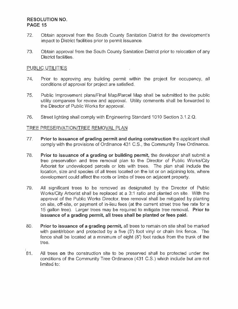
72. Obtain approval from the South County Sanitation District for the development's impact to District facilities prior to permit issuance.
73. Obtain approval from the South County Sanitation District prior to relocation of any District facilities.
PUBLIC UTILITIES
7 4. Prior to approving any building permit within the project for occupancy, all conditions of approval for project are satisfied.
75. Public Improvement plans/Final Map/Parcel Map shall be submitted to the public utility companies for review and approval. Utility comments shall be forwarded to the Director of Public Works for approval.
76. Street lighting shall comply with Engineering Standard 1010 Section 3.1.2.Q.
TREE PRESERVATION/TREE REMOVAL PLAN
77. Prior to issuance of grading permit and during construction the applicant shall comply with the provisions of Ordinance 431 C.S., the Community Tree Ordinance.
78. Prior to issuance of a grading or building permit, the developer shall submit a tree preservation and tree removal plan to the Director of Public Works/City Arborist for undeveloped parcels or lots with trees. The plan shall include the location, size and species of all trees located on the lot or on adjoining lots, where development could affect the roots or limbs of trees on adjacent property.
79. All significant trees to be removed as designated by the Director of Public Works/City Arborist shall be replaced at a 3:1 ratio and planted on site. With the approval of the Public Works Director, tree removal shall be mitigated by planting on site, off-site, or payment of in-lieu fees (at the current street tree fee rate for a 15 gallon tree). Larger trees may be required to mitigate tree removal. Prior to issuance of a grading permit, all trees shall be planted or fees paid.
80. Prior to issuance of a grading permit, all trees to remain on site shall be marked with paint/ribbon and protected by a five (5') foot vinyl or chain link fence. The fence shall be located at a minimum of eight (8') foot radius from the trunk of the tree.
"81. All trees on the construction site to be preserved shall be protected under the conditions of the Community Tree Ordinance (431 C.S.) which include but are not limited to:

RESOLUTION NO. PAGE16
a. No mechanical trenching within the drip line of a tree, unless approved by the Parks and Recreation Director.
b. No storage of equipment, supplies, tools, etc., within 8' of the trunk of any tree.
c. No grading shall occur under a trees dripline, unless approved by the Public Works Director.
d. A five foot (5') protective fence shall be constructed a minimum of 8' from the trunk of each tree.
82. All trees to be pruned shall be pruned under supervision of a Certified Arborist using the International Society of Arboriculture (ISA) Pruning Standards.
PUBLIC SAFETY
83. Prior to issuance of building permit, applicant to submit exterior lighting plan for Police Department approval.
AGREEMENTS
84. Inspection Agreement: Prior to approval of an improvement plan, the applicant shall enter into an agreement with the City for inspection of the required improvements.
85. Subdivision Improvement Agreement: The applicant shall enter into a subdivision agreement for the completion and guarantee of improvements required. The subdivision agreement shall be on a form acceptable to the City.
86. Maintenance Agreement: Prior to recording the final map, a joint maintenance agreement for the project's drainage system and detention basins shall be submitted for the review and approval of the City Attorney. The joint maintenance agreement shall be recorded prior to or concurrently with the final map
OTHER DOCUMENTATION
87. Preliminary Title Report: A current preliminary title report shall be submitted to the Director of Public Works prior to checking the map. A current subdivision guarantee shall be submitted to the Director of Public Works prior to recording the Map.
PRIOR TO ISSUING A BUILDING PERMIT
88. 124. The Final Map shall be recorded with all pertinent conditions of approval satisfied.

RESOLUTION NO. PAGE17
PRIOR TO ISSUING A CERTIFICATE OF OCCUPANCY
89. All utilities shall be operational.
90. All essential project improvements shall be constructed prior to occupancy. Nonessential improvements, guaranteed by an agreement and financial securities, may be constructed after occupancy as directed by the Community Development Director.
91 . Prior to the final 10% of occupancies for the project are issued, all improvements shall be fully constructed and accepted by the City.
FEES AND BONDS The applicant shall pay all applicable City fees, including the following:
92. FEES TO BE PAID PRIOR TO PLAN SUBMITTAL a._ Map check fee for tract map. b._ Plan check for grading plans.
(Based on an approved earthwork estimate) c._ Plan check for improvement plans.
(Based on an approved construction cost estimate) d._ Permit Fee for grading plans.
(Based on an approved earthwork estimate) e._ Inspection Fee of subdivision or public works construction plans.
(Based on an approved construction cost estimate) f. Plan Review Fee
(Based on the current Building Division fee schedule)
93. FEES TO BE PAID PRIOR TO RECORDATION OF THE FINAL MAP a._ Park Development fee, the developer shall pay the current park
development fee, and/or donate land in-lieu of, for each lot approved, in accordance with City Ordinance 313 C.S.
b._ Park Dedication, the developer shall dedicate, in accordance with City Ordinance 313 C.S., land for park purposes.
c. Park Improvement fee, the developer shall pay the current park improvement fee, for each lot approved, in accordance with City Ordinance 313 C.S.
d._ Affordable Housing In-Lieu Fee, in accordance with Chapter 16.80 of the Development Code.
94. FEES TO BE PAID PRIOR TO ISSUANCE OF A BUILDING PERMIT a. Water Neutralization fee, to be based on codes and rates in effect
at the time of building permit issuance, involving water connection or enlargement of an existing connection.
b. Water Distribution fee, to be based on codes and rates in effect at

RESOLUTION NO. PAGE18
the time of building permit issuance, in accordance with Municipal Code Section 13.04.030.
c._ Water Meter charge to be based on codes and rates in effect at the time of building permit issuance, in accordance with Municipal Code 6-7.22.
d._ Water Availability charge, to be based on codes and rates in effect at the time of building permit issuance, in accordance with - (not correct).
e._ Traffic Impact fee, to be based on codes and rates in effect at the time of building permit issuance, in accordance with Ord. 461 C.S., Res. 3021.
f. Traffic Signalization fee, to be based on codes and rates in effect at the time of building permit issuance, in accordance with Ord. 346 C.S., Res. 1955.
g._ Sewer Connection fee, to be based on codes and rates in effect at the time of building permit issuance, in accordance with Municipal Code Section 13.12.190.
h._ South San Luis Obispo County Sanitation District Connection fee in accordance with Municipal Code Section 13.12.180.
i. Drainage fee, as required by the area drainage plan for the area being developed.
j._ Park Development fee, the developer shall pay the current parks development fee for each unit approved for construction (credit shall be provided for existing houses), to be based on codes and rates in effect at the time of building permit issuance in accordance with Ord. 313 C.S.
k._ Construction Tax, the applicant shall pay a construction tax pursuant to Section 3-3.501 of the Arroyo Grande Municipal Code.
I._ Alarm Fee, to be based on codes and rates in effect at the time of development in accordance with Ord. 435 C.S.
m._ Strong Motion Instrumentation Program (SMIP) Fee, to be based on codes and rates in effect at the time of development in accordance with State mandate.
n._ Building Permit Fee, to be based on codes and rates in effect at the time of development in accordance with Title 8 of the Municipal Code.
BONDING SURETY
95. Prior to issuance of the grading or building permit, all new residential construction requires posting of a $1,200.00 perfo~mance bond for erosion control and damage to the public right-of-way. This bond is refundable upon successful completion of the work, less expenses incurred by the City in maintaining and/or restoring the site.

RESOLUTION NO. PAGE19
96. The applicant shall provide bonds or other financial security as listed in this condition. All bonds or securities shall be in a form acceptable to the City, and shall be provided prior to recording of the map, unless noted otherwise. The minimum term for Improvement securities shall be equal to the term of the subdivision agreement.
a. Faithful Performance, 100% of the approved estimated cost of all subdivision improvements.
b. Erosion Control and Landscape, 100% of the approved estimated cost of all erosion control work during construction and the estimated cost of all final landscaping after construction is complete. This bond is refundable upon successful completion of the work, less expenses incurred by the City in maintaining and/or restoring the site.
c. Labor and Materials, 50% of the approved estimated cost of all subdivision improvements.
d. One Year Guarantee, 10% of the approved estimated cost of all subdivision improvements. This bond is required prior to acceptance of the subdivision improvements.
e. Monumentation, 100% of the estimated cost of setting survey monuments.
f. Tax Certificate, In accordance with Section 9-15.130 of the Development Code, the applicant shall furnish a certificate from the tax collector's office indicating that there are no unpaid taxes or special assessments against the property

RESOLUTION NO. PAGE 20
MITIGATION MEASURES
A negative declaration with mitigation measures has been adopted for this project. The following mitigation measures shall be implemented as conditions of approval and shall be monitored by the appropriate City department or responsible agency. The applicant shall be responsible for verification in writing by <the monitoring department or agency that the mitigation measures have been implemented.
MM 1-1: Prior to issuance of a building permit to construct a home on an individual lot within the subdivision, the Architectural Review Committee shall review the design of the home through the Architectural Review permit application process. Homes shall be similar in design to those within the adjacent Grace Lane and Rancho Grande subdivisions. Special attention shall be placed on the massing and exterior colors and materials of individual homes to lessen the visual impact from US Highway 101 and residential development to the east.
Responsible Party: Monitoring Agency: Timing:
Developer City of Arroyo Grande - Planning Division Prior to issuance of a building permit
MM 111-1: On-road diesel vehicles shall comply with Section 2485 of Title 13 of the California Code of Regulations. This regulation limits idling from dieselfueled commercial motor vehicles with gross vehicular weight ratings of more than 10,000 pounds and licensed for operation on highways. It applies to California and non-California based vehicles. In general the regulation specifies that drivers of said vehicles:
• Shall not idle the vehicle's primary diesel engine for greater than 5 minutes at any location.
• Shall not operate a diesel-fueled auxiliary power system (APS) to power a heater, air conditioner, or any ancillary equipment on that vehicle during sleeping or resting in a sleeper berth for greater that 5 minutes at any location when within 1,000 feet of a restricted area.
Responsible Party: Monitoring Agency:
Timing:
Developer City of Arroyo Grande - Engineering Division, Public Works Department During Construction
MM 111-2: Off-road diesel equipment shall comply with the 5 minute idling restriction identified in Section 2449(d)(2) of the California Air Resources Board's In-Use Off-Road Diesel regulation.

RESOLUTION NO. PAGE 21
Responsible Party: Monitoring Agency:
Timing:
Developer City of Arroyo Grande - Engineering Division, Public Works Department During Construction
MM 111-3: Signs must be posted in the designated queuing areas and job sites to remind drivers and operators of the State's 5 minute idling limit.
Responsible Party: Monitoring Agency:
Timing:
Developer City of Arroyo Grande - Engineering Division, Public Works Department During Construction
MM 111-4: The project applicant shall comply with these more restrictive requirements to m1mm1ze impacts to nearby sensitive receptors (adjacent residential development):
• Staging a queuing areas shall not be located within 1,000 feet of sensitive receptors;
• Diesel idling within 1,000 feet of sensitive receptors shall not be permitted; • Use of alternative fueled equipment is recommended; and • Signs that specify no idling areas must be posted and enforced at the site.
Responsible Party: Monitoring Agency:
Timing:
Developer City of Arroyo Grande - Engineering Division, Public Works Department During Construction
MM 111-5: The project shall implement the following mitigation measures to manage fugitive dust emissions such that they do not exceed the APCD's 20% opacity limit (APCD Rule 401) or prompt nuisance violations (APCD Rule 402):
• Reduce the amount of the disturbed area where possible; • Use of water trucks or sprinkler systems in sufficient quantities to prevent
airborne dust from leaving the site and from exceeding the APCD's limit of 20% opacity for greater than 3 minutes in any 60 minute period. Increased watering frequency would be required when wind speeds exceed 15 mph. Reclaimed (non-potable) water should be used whenever possible;
• All dirt stock pile areas should be sprayed daily and covered with tarps or other dust barriers as needed;
• Permanent dust control measures identified in the approved project revegetation and landscape plans shall be implemented as soon as possible, following completion of any soil disturbing activities;

RESOLUTION NO. PAGE 22
• Exposed ground areas that are planned to be reworked at dates greater than one month after initial grading should be shown with a fast germinating, non-invasive, grass seed and watered until vegetation is established;
• All disturbed soil areas not subject to revegetation should be stabilized using approved chemical soil binders, jute netting, or other methods approved in advance by the APCD;
• All roadways, driveways, sidewalks, etc. to be paved should be completed as soon as possible. In addition, building pads should be laid as soon as possible after grading unless seeding or soil binders are used;
• Vehicle speed for all construction vehicles shall not exceed 15 mph on any unpaved surface at the construction site;
• All trucks hauling dirt, sand, soil, or other loose materials are to be covered or should maintain at least two feet of freeboard (minimum vertical distance between top of load and top of trailer) in accordance with eve Section 23'114;
• Install wheel washers where vehicles enter and exit unpaved roads onto streets, or wash off trucks and equipment leaving the site;
• Sweep streets at the end of each day if visible soil material is carried onto adjacent paved roads. Water sweepers shall be used with reclaimed water should be used where feasible. Roads shall be pre-wetted prior to sweeping when feasible;
• A listing of all required mitigation measures should be included on grading and building plans; and,
• The contractor or builder shall designate a person or persons to monitor the fugitive dust emissions and enhance the implementation of the measures as necessary to minimize dust complaints, reduce visible emissions below the APCD's limit of 20% opacity for greater than 3 minutes in any 60 minute period. Their duties shall include holidays and weekend periods when work may not be in progress. The name and telephone number of such persons shall be provided to the APCD Compliance Division prior to the start of any grading, earthwork or demolition.
Responsible Party: Monitoring Agency:
Timing:
Developer City of Arroyo Grande - Engineering Division, Public Works Department During Construction
MM 111-6: Prior to the start of the project, the applicant shall obtain all necessary1 permits for equipment to be used during construction by contacting the APCD Engineering Division at (805) 781-5912.

RESOLUTION NO. PAGE 23
Responsible Party: Monitoring Agency:
Timing:
Developer City of Arroyo Grande - Engineering Division, Public Works Department Prior to start of work
MM 111-7: Prior to any grading activities, the project sponsor shall ensure that a geologic evaluation is conducted to determine if naturally occurring asbestos (NOA) is present within the area that will be disturbed. If NOA is not present, an exemption request must be filed with the APCD. If NOA is found at the site, the applicant must comply with all requirements outlined in the Air Resource Board (ARB) Air Toxics Control Measure (ATCM) for Construction, Grading, Quarrying and Surface Mining Operations.
Responsible Party: Monitoring Agency:
Timing:
Developer City of Arroyo Grande - Engineering Division, Public Works Department, APCD Prior to issuance of grading permit
MM 111-8: Burning of vegetative material on the development site shall be prohibited.
Responsible Party: Monitoring Agency:
Timing:
Developer City of Arroyo Grande - Engineering Division, Public Works Department During Construction
MM 111-9: Should hydrocarbon-contaminated soil be encountered during construction activities, the APCD shall be notified within forty-eight (48) hours of such contaminated soil being discovered to determine if an APCD permit is required. In addition, the following measures shall be implemented immediately after contaminated soil is discovered:
• Covers on storage piles shall be maintained in place at all times in areas not actively involved in soil addition or removal.
• Contaminated soil shall be covered with at least six (6) inches of packed, uncontaminated soil or other TPH - non-permeable barrier such as plastic tarp. No headspace shall be allowed where vapors could accumulate.
• Covered piles shall be designed in such a way as to eliminate erosion due to wind or water. No openings in the covers are permitted.
• During soil excavation, odors shall not be evident to such a degree as to J
cause a public nuisance. · • Clean soil must be segregated from contaminated soil.
RESOLUTION NO. PAGE 24
Responsible Party: Monitoring Agency:
Timing:
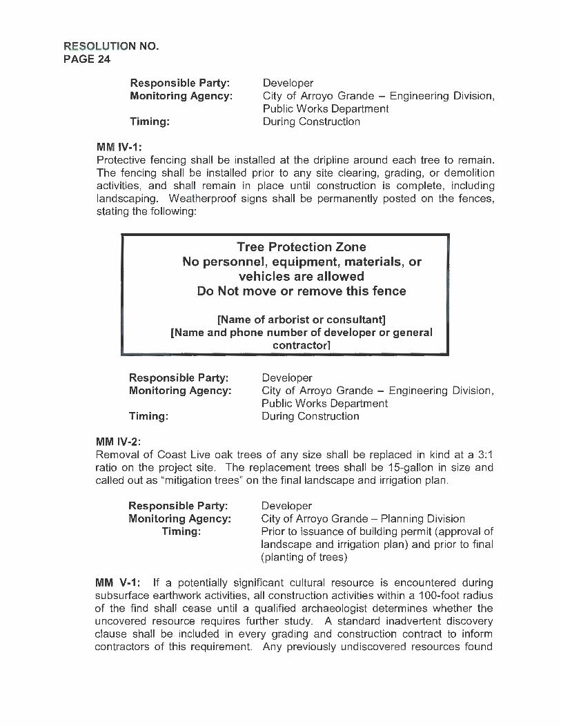
MM IV-1:
Developer City of Arroyo Grande - Engineering Division, Public Works Department During Construction
Protective fencing shall be installed at the dripline around each tree to remain. The fencing shall be installed prior to any site clearing, grading, or demolition activities, and shall remain in place until construction is complete, including landscaping. Weatherproof signs shall be permanently posted on the fences, stating the following:
Tree Protection Zone No personnel, equipment, materials, or
vehicles are allowed Do Not move or remove this fence
[Name of arborist or consultant] [Name and phone number of developer or general
contractor]
Responsible Party: Developer Monitoring Agency:
Timing:
MM IV-2:
City of Arroyo Grande - Engineering Division, Public Works Department During Construction
Removal of Coast Live oak trees of any size shall be replaced in kind at a 3: 1 ratio on the project site. The replacement trees shall be 15-gallon in size and called out as "mitigation trees" on the final landscape and irrigation plan.
Responsible Party: Monitoring Agency:
Timing:
Developer City of Arroyo Grande - Planning Division Prior to issuance of building permit (approval of landscape and irrigation plan) and prior to final (planting of trees)
MM V-1: If a potentially significant cultural resource is encountered during subsurface earthwork activities, all construction activities within a 100-foot radius of the find shall cease until a qualified archaeologist determines whether the uncovered resource requires further study. A standard inadvertent discovery clause shall be included in every grading and construction contract to inform contractors of this requirement. Any previously undiscovered resources found

RESOLUTION NO. PAGE 25
during construction shall be recorded on appropriate California Department of Parks and Recreation (DPR) forms and evaluated for significance in terms of California Environmental Quality Act criteria by a qualified archaeologist. Potentially significant cultural resources consist of, but are not limited to, stone, bone, glass, ceramic, wood, or shell artifacts; fossils; or features including hearths, structural remains, or historic dumpsites. If the resource is determined significant under CEQA, the qualified archaeologist shall prepare and implement a research design and archaeological data recovery plan that will capture those categories of data for which the site is significant. The archaeologist shall also perform appropriate technical analysis, prepare a comprehensive report, and file it with the appropriate Information Center and provide for the permanent curation of the recovered materials.
Responsible Party: Monitoring Agency:
Timing:
Developer City of Arroyo Grande - Engineering Division, Public Works Department During construction
MM V-2: If human remains are encountered during earth-disturbing activities, all work in the adjacent area shall stop immediately and the San Luis Obispo County Coroner's office shall be notified. If the remains are determined to be Native American in origin, the Native American Heritage Commission shall be notified and will identify the Most Likely Descendent, who will be consulted for recommendations for treatment of the discovered remains.
Responsible Party: Monitoring Agency:
Timing:
Developer City of Arroyo Grande - Engineering Division, Public Works Department During construction
MM Vll-1: Prior to issuance of a building permit, all construction plans shall incorporate the following GHG-reducing measures where applicable:
• Incorporate outdoor electrical outlets to encourage the use of electric appliances and tools.
• No residential wood burning appliances. • Trusses for south-facing portions of roofs shall be designed to handle
dead weight loads of standard solar-heated water and photovoltaic panels. Roof design shall include sufficient south-facing roof surface, based on structures size and use, to accommodate adequate solar panels. For south facing roof pitches, the closest standard roof pitch to the ideal average solar exposure shall be used.
• Increase the building energy rating by 20% above Title 24 requirements. Measures used to reach the 20% rating cannot be double counted.

RESOLUTION NO. PAGE 26
• Plant drought tolerant, native shade trees along southern exposures of buildings to reduce energy used to cool buildings in summer.
• Utilize green building materials (materials which are resource efficient, recycled, and sustainable) available locally if possible.
• Install high efficiency heating and cooling systems. • Design homes to include roof overhangs that are sufficient to block the
high summer sun, but not the lower winter sun, from penetrating south facing windows (passive solar design).
• Utilize high efficiency gas or solar water heaters. • Utilize built-in energy efficient appliances (i.e. Energy Star®). • Utilize double-paned windows. • Utilize energy efficient interior lighting. • Install energy-reducing programmable thermostats. • Use roofing material with a solar reflectance values meeting the EPA/DOE
Energy Star® rating to reduce summer cooling needs. • Eliminate high water consumption landscaping with emphasis on native
plants.
Responsible Party: Monitoring Agency:
Timing:
Developer City of Arroyo Grande - Planning, Building and Engineering Divisions Prior to issuance of a Grading Permit or Building Permit
MM IX-1: The following BMPs shall be incorporated into the project:
• Roof Downspout System. Direct roof drains to pervious areas to allow infiltration prior to discharging to water bodies or the municipal storm drain system.
• Run-off Control. Maintain post-development peak runoff rate and average volume of runoff at levels that are similar to pre-development levels.
• Labeling and Maintenance of Storm Drain Facilities. Label new storm drain inlets with "No Dumping - Drains to Ocean" to alert the public to the destination of stormwater and to prevent direct discharge of pollutants into the storm drain.
Responsible Party: Monitoring Agency:
Timing:
Developer City of Arroyo Grande - Planning, Building, and Engineering Divisions Prior to issuance of a Building Permit

RESOLUTION NO. PAGE 27
MM Xll-1: Construction activities shall be restricted to between the hours of 8 a.m. and 5 p.m. Monday through Friday. No construction shall occur on Saturday or Sunday. Equipment maintenance and servicing shall be confined to the same hours. To the greatest extent possible, grading and construction activities should occur during the middle of the day to minimize the potential for disturbance of neighboring noise sensitive uses.
Responsible Party: Monitoring Agency:
Timing:
Developer City of Arroyo Grande - Planning, Building, and Engineering Divisions During construction
MM Xll-2: All construction equipment utilizing internal combustion engines shall be required to have mufflers that are in good condition. Stationary noise sources shall be located at least 300 feet from occupied dwelling units unless noise reducing engine housing enclosures or noise screens are provided by the contractor.
Responsible Party: Monitoring Agency:
Timing:
Developer City of Arroyo Grande - Planning, Building, and Engineering Divisions During construction
MM Xll-3: Equipment mobilization areas, water tanks, and equipment storage areas shall be placed in a central location as far from existing residences as feasible.
Responsible Party: Monitoring Agency:
Timing:
Developer City of Arroyo Grande - Planning, Building, and Engineering Divisions During construction

~-'\_ iJ__ ---n- ---- ___ r1 ______ __ _ ~
IBCTIOM " A·A" Dl.AIMAOB aAllM Cl.Oii IBCTIOM "°'""'
VICINITY MAP
LEGEND
PARCJ:l. SOiJNIJARr -DtISTINC_./Vi'
DOS/WC"""' DnS1WG EUCfRIC
""'°"' £X/Sl/NC 1REI (TD R£JWH tml.LS!iN0f'(f)OTH£TiWIS£)
EXrSllNC~lf'fDRNff
PflOPOSEOf'lli:tffl'OIWff
EXISnNC srRm Wff
fflCf'OS£l) """'"""
0 ,. •
~:~~ ~~~\~>o:::~-0=:c£E-"~':E:~4illr~, ~~~J':@f~~~~:.;:::Ar.?.::;<--:;_-p~ '""""""""""' C-:::: - - l ~:IN/.ilS""-'I /X'~~'.._~:.<·::}"~~_,.~~~~~~ ....... :~-- __. ( .•~ -.--~ -
IL-I BCTIOM • 1.a•
J1Ml$!1CAAOE
lf0r£: ~OWS~llll'/JUIN
~~-
Dl. AIMAOB IAllM Cl.Oii IBCTIOM
""" """ 52' RIGHT OF ll'AI"
" 20' 20' SIOClt'A~K
,,. ,,. 8' "'"" lRA\.fl 8'
PARKING I LANE WI£ I PARKING
~ • ~ \_~. Sl0£WALKP£R
4 . MIN AC PA\ll'NG ON
TO CITY sros. 6" CONC. CURB .t GUTTER PER CITY sros.
r CL II &tS£ Ollf'Ji' 12" R£COUPACTffl SU8CRADC 8AS£D ON A T.I. OF 6.5.
TYP ICAL STREET SECTION
~VESTING CZJD T E N T A T I V E
zoa;~
MAP SCALE. l . s 40
. · , . i :b
TREE LEGEND
0015T.Tfl£E cue. CUC.t.L""TVS
' -NOTES
I. SlWA~OISPOSIJ. P!l()Ylf)£D8YCITYOF..wlt11t1Gl'.AJ<IJ€ 2. *4TfHSOMCEfflrMlJED81'MCITYOFMNOlt1GIWJOC J APN: 001-011-041 4. WHJIJS£D£5JGN1TIOH: SFNLOWODISIT"r. S. frJfALSJ1CAR£4:1.S1N:lifS.
.1 - i
~ ,---1 ~;,' ~I
l-----1~- ~i-T I -f7 VESTING
TENTATIVE MAP FOR
~
m
--1.4!
m~
ROAD PROFILE
UTILITIES AT.tT /02CHOS:SSff{£Er SAHtUIS~,C49J401
8015-16..Nll
PADFJCG4Sit£1.£CfRICE
"""""""""" SAHlUfSa!llSl'D. C4 9MO/ 600.U.J.5000
S&e¥AMJ #!ATER arr or MWOro GRAND£ 214 l 8PAHCH srRm Ami'Ol't!GIW«JC.049.HZO
,,,,,..,_,,,, J1.J6/NOtl5TRIAL~r
SNITA .IWM C4 93455
""'""""" f29!JIW:;cS'fREET Ni'l'iOl'OCIWll)£.C49.>f20 805."89.265J
TRACT NO. 3079 SElrJC A suaONISIOH Of LOI 134 or !FU.Cl 1m. 1J90. RECORDEO IN
BOOK 14. P#.G[ n Of M.IPS , IN Tri[ COUNT't or $411 lWS OBISPO. STAl'(OrOJ..ll"ORIJIA INTO 7 RESIOi:UTLALlOTS RANCirJC IH SIZ(fll~
H .914 SOUIJ!( rm IO ~7,&02 501.JAA( r ECT l.tl!JONt: Qff(R or DEOK:ATION fOR ~O.IJJWAY P\lllPOSES Of 12.12S SOtiAA( f"Efl .
r::rr-v •
O.r>en/k>!>k"'"l
K>rbyGoracn
GordonPropcr(;c•
760r..ott<.R0<1d, Sui1 cA I P;smo Boo<n. Co, 9JH~
(60~) 17J-2610
SURI/EV DATE: 07/11/ I ~ PLOT D"'-TE. 06/~5/16 ru N.o,_<,j(; m.1 O~U16. DWG
&!i'BQW @'WK r&lfD&/JA
Jclfrc, J [ m1it k. P.E. RC[ 1 406~7 EXP . J/li/2017
r~11 Ci•l.I £n,i-•nn, Suriwyi.ng Pro~r:l Dr11do1rm..i1n!
...... -~ GarinaTavlor I '" '°"'" ... , ..... &. Associates ~~'i ~·~·;~;3 [1" u•20
m >< ::c o:i =i o:i
I
~

AP N: 007-0 11-041
h)9.66SOFl .-.......~~ ,,,,,M,~IW I
/
/
\..'?>.,..e _.,.,-·
G~~~ -/
_,.,· ·
/
/ p
-~;..~''-' ~
.~/sc.AJ....E 1· -40·
Legend
c-=i 7"A. or lu• Slopo
IICID 1· 1S%Slop•
~2S% •n• l upS11>~
Table of Values
!tw. Aru!Sg.FLI %oflola!5a.FL
To1>11·l05,107.2J Sq.H ... •a.S!op•·J6'llo
..... ~ %o1Tolo1Sa Fl.
TolAl-J&.JllSq..Ft Avg.Slop•·•!,..
~ ~ %a! To1.iS? Fl
To!•l·J7.479Sq.FI A>g, SlopA-51%
- ~ ~ 18,12>.SllSq, Ft
To!AI . J7,n~ S•1 . FL A,•g. SlarG -37~~
""' ~ ~
T01Al-ll,J5'15<1.Fl. A"!1-51-·2C".
fil2I!!!. I Nu!S<1 Fl l Y.nfl91AIS9F1
Tolal·S7 ,602Sq.H A"i-Slope·J4,-.
""' ~ ~
TolAl·S5,17JSa. H A•11.S lop•-~O\'.
~ ~ %o1Tol.o1Sq. FL
6~7.USn.FL
9.15960S11FL
Toi~!· 25, l lOSa.fL A"1J. Slone -25'!1.
Slope Exhibit
m >< :r:: llJ -4 llJ
"'

l!- -~ IJICTJOX • A·A•
JJCTIOH •J . J• DI.AINA.OB JAlllf Cl. Oii IB C TIOJC
TYPICAL STR.BBT SECTION
=-VESTING
TRACT 3079 DESIGN GUIDELINES
Rodeo Court Arroyo Grande, CA 93420
UTILITIBS IOJ'llll>flr.trrr -108_,CO.,_,, _,.,,
CZJ~ T E N T A T I V E MAP -llf'1Wlrll0!77 -~Ol~JJ:
IO:l•Jn.•
Prepared by: Garing Taylor & Associates
141 South Elm Street Arroyo Grande, CA 93420
Date Approved: ____ _
EXHIBITC
• ...,t.. .....
!"'! - .•. ,,.:
-·--~ _., ----------
[_:-_-_l
TR.BE LBGBND
N OTBS .,...,.._._,,t:f',Y--'· ........ ~~, .... ,,,,..,_...,_.,,_ ~ .....,/U.<OIQll,.,. S111or;io,s.r,y l ~=-.u, _..
VESTING
TENTATIVE MAP FOR
TRACT NO. 3079
"'"°''·~•.,;;'.>.7 .""'1 < ·'1~~- .. ," 'fi'i'f':i"" ..:no., ... "J: " ) I"' ,,,..,..;.,. ...... . : .......... ~.,..,.;.,;~,.~
~··e ~ r""""" ,.,... ' =·~" :r.: •;.= -. -::r """ ;• .•" ·.::.:o><fm'>'·' ~.,~,,,.. uc; oosrP>o<
:D:Jfr>e,.,,.,: ......... ~-u:.-.. ,,,.,,,.,,.""''Tt:
------------
.,,.,.,. ... ,. ,,,_,.,.,, ~:r.cr.r.t~<
"' ''"""'''-"""" .. ~ ... 'I"' '

Rodeo Court Design Guidelines - Table of Contents
Section 1: Design Goals Setting ... .......................... .. ............ .. .. .............. .... .. .... .... ... 1 Concept.................................. .. ... .. ........ ........ .. ... .. ... .. .... ... 1 Intent . . . ............ ...... .. ...... ...... .............. ................................ 1 Application . . . . . . . . . .. . . .. ... . . . . . . . . . . . . . . . . . . . .. . . . . . . . . . . . . . .. . . . . .. . . . . . . . . . . . . 1 Common Facilities ... ....................... .. ........... .. ................... 1
Section 2: Site Design Drainage ... ........................................................................ 2 Grading.............................. ................................ .............. . 2 Building Envelopes .. . .. .. . . .. .. .. .. .. .. .. .. .. ... .. .... .. .. .. . .. .. .. . .. .. ... .. 2 Building Heights.......................... . ...... ............ .. ........ 2
Section 3: Building Design Style and Character . .. .. .. .. . .. .. . .. .... .. .. .. ........ ...... .. ........ ..... .. 3 Driveway & Garages .. . .. .. . .. .. .. .. .. .. .. .. . .. .. .. .. .. .. .. .. .. . .. .. .. .. .. . .. 3 Architectural Features .. .......... .... .. .... ................................. 3 Articulation . . . . . . . .. . . . . . . . .. .. . . . . . . . . . . . . . . . . . . . . . . .. . . .. . . .. .. .. . .. .. .. .. . . . .. .. 3 Entries .............................................................................. . Garage Doors .................................................................. . Exterior Materials ............................. .................... ............ . Exterior Colors .... ..... ..... .. .. ............ ................................... . Roof Materials .... ........ .... ......... ........ ............. ..... ......... ...... . Roof Drainage ................... .. ........ ......... ............................ . Trash Containers .............................................................. . Mechanical Equipment .................................................... .. Satellite Dishes & Antennas ............................................. . Fire Sprinklers ......... ... ............ ... .. ............... ......... ............. . Lighting ....................................... ......... ............................ .. Secondary Living Units .................................................... .. Water Conservation .......... ....... ...... ..... ................... .......... . . Energy Efficiency ... .. .. ...... ......................... ..... ................... .
Section 4: Site Improvements
3 3 4 4 4 4 4 4 4 5 5 5 5 5
Hard scape . . . . . . . . . . . . . . . . .. . . . . . . . . . . . . . . . . . . . . . . . . .. .. . . . . .. .. . .. . .. .. .. . . . . .. .. . 6 Landscaping . . . . .. . . . . . . . .. . . . . .. . . .. . . .. .. . . . . . . . . . .. .. . .. .. .. . . . . . . . . . .. .. .. .. . . 6 Fencing ... ........................................................................... 6
Exhibit Fencing .. . . . ............................. ........ ................................ ... 8
I
Lot Development Standards Table ... ........... ....... ... ......... ....... 9

Section 1: Design Goals
Setting The Rodeo Court project comprises approximately 7.52 acres of residential land located in the North Eastern portion of the City of Arroyo Grande. The site consists of a large graded pad with slopes up to 2:1 around the perimeter of the pad.
Concept The overall design concept is to provide an individual, unique and separate design for each lot. While there may be similarities and consistencies in design detail, the overall concept is to have each lot provide a different, or varied by architectural component selection, exterior color and roof configuration.
Intent These design guidelines are intended to facilitate sensitive and quality building designs that compliment the project setting. This is accomplished by providing flexible design and development standards, which assures compatibility of scale and character within the development without limiting imagination and individuality. All construction within the development is subject to the provision of title 16 of the City of Arroyo Grande Municipal Code and all applicable development standards, except as modified herein, by tract approval documents or other City approvals.
Application These design guidelines apply to all new construction and remodel projects within the tract. All construction drawings must be reviewed by the Community Development Director for consistency with these guidelines prior to issuance of a building permit through the Architectural Review process. If the Community Development Director finds that the construction drawings are inconsistent with these guidelines, the proponent may appeal the Director's finding to the Planning Commission.
1

Section 2: Site Design
Drainage Historically, storm water and drainage has drained from the site to the adjacent regional detention basin. Each residence will be required to mitigate storm water flows in conformance with City of Arroyo Grande standards and Regional Water Board requirements
Low Impact Development measures will be required on each lot to mitigate and control the increased storm water impacts from the residences. A number of options may be implemented by the property owners and must be detailed on Architectural Design Review applications.
Examples of storm water best management practices include detention basins, bioretention planter boxes, rain barrels, rain gardens, dry wells, disconnected down spouts, cistern water collection and storage.
Grading It is the intent of the project to minimize grading for structure development and outdoor spaces and maximize opportunities for storm water infiltration. Grading on Lots 1 and 2 to integrate the residence with the existing slope will be required.
Building Envelopes Building envelopes have been developed to minimize the impact of the residences on views across the tract and maximize the view potential for each lot.
In an effort to provide visual interest to the relationship between structure and street, horizontal building wall articulation is encouraged. Additionally, vertical building articulation to step the building mass at multistory designs is desired. Providing a varied roof profile with roof lines generally lower at the edges of the building and graduating in height as they move towards the interior of the building can achieve this effect.
Based on site constraints, building sites shall generally conform to the Single Family Residential (SF) zoning standards with the following setbacks. For lots 1-3 and 5-7 a required 20' front setback and 1 O' side yard setback is required. The rear setback is limited to the building envelope. For Lot 4 a 1 O' setback on all sides is required with the exception of the rear yard which is defined by the building envelope.
Construction within the drip line area of oak trees is not allowed, unless an exception is made by the Community Development Director based on a design specific tree protection plan prepared by a certified arborist.
Building Heights Building height limits for Lots 1-5 shall be per City of Arroyo Grande Development Code (25 feet from original grade) and 15 feet from the finish floor elevation noted on the Tentative Map (219.5 for Lot 6 and 218.5 for lot 7).
2

Section 3: Building Design
Style and Character While no particular design style is required, it is encouraged that all designs be consistent with an overall character, or vocabulary of acceptable details. Architectural styles shall be low profile at all lots. Detailing and materials appropriate to the chosen styles are envisioned and include, but are not limited to Farmhouse, Craftsman, Cottage, Bungalow, Prairie and Spanish Eclectic. Inappropriate styles include Victorian, Tudor and Colonial due to high roof pitches and/or flat 2 story wall planes to replicate the style. Mid Century Modern styles with flat or mansard roofs are not appropriate.
Driveways and Garages The concept of "street elevation" is encouraged. As such, it is recommended that a variety of garage locations be considered. These include front loaded, side loaded in the front yard area and rear yard locations (front, side and rear loading). Garages may be attached or detached, depending on overall building design and/or site constraints. These variations will provide a more individual look and varied site plan for the project.
Outdoor storage of recreational vehicles, boats, trailers, etc., is not permitted unless such vehicles are stored in covered or enclosed structures or located in yard areas screened from public view.
Lots 4 and 5 are required to provide an emergency vehicle turnaround.
Architectural Features The use of architectural features such as porches, arbors, trellises and garden walls are encouraged to assist in building articulation. Articulation and varying finish materials, either horizontally or vertically, should minimize large single plan wall expanses (i.e. masonry veneer or wainscot, varied siding materials, etc.).
Articulation The use of varying ridge heights, wall planes and roof articulations provides variety to the overall building mass. Roof elements such as dormers may also be used to break up large roof masses. Primary roof planes should be low pitched (3:12 to 6:12). Eave lines shall be dominantly horizontal.
Homes constructed on lots 5-7 shall have detailed articulation and/or additional screening on the rear building elevation facing the street to improve the aesthetic views from Grace Lane and Rodeo Drive.
Entries Entries shall be architecturally defined, appropriately detailed and obvious with a defined walkway from the public right of way, or off the approach driveway area. Entries should be covered and complimented with obvious enhancements such as porches, courtyards, flatwork finished, windows, etc.
3

Garage Doors Garage door styles shall be detailed appropriately to enhance the chosen architectural style. Recessed double car or staggered single car garage doors are encouraged.
Exterior Materials Exterior materials such as horizontal siding, board and batt siding, shingles or plaster are appropriate. Plaster may be used as appropriate to a specific style (i.e. Spanish eclectic, Bungalow, etc.); however, detailing and articulation are required. Masonry (either brick, split faced concrete block, or any articulated masonry material) can be utilized as a veneer, or compliment, to exterior stucco or siding finishes.
Exterior Colors Exterior colors should create visual compatibility between the structures and the natural surroundings. Exterior colors should be of individually coordinated palettes. Simple color schemes consisting of a maximum of 3 colors are recommended. Masonry materials have distinct coloring and shall be considered as an element of the color palette. The use of natural materials is encouraged.
Roof Materials Roof coverings appropriate for use include clay tile, concrete tile or dimensional shingle roofing. Metal or flat shingle roofing is not appropriate. All flashing, sheet metal, vents and pipe stacks shall be painted to match the adjacent roof or wall material. Exposed copper is also allowed. Skylights and sun tunnels shall be low profile, flat panel glazed. Solar collector panels, if used, shall be low profile and installed planar with roof surfaces. Panels shall be incorporated into roof design and installed flush with roof materials where possible.
Roof Drainage Gutters and downspouts shall be installed on all roof areas to control water generated during a storm event. Gutters and downspouts shall be color coordinated with the structure. Individual disbursement methods are to be determined based upon each individual property constraints; however, each property shall disburse the water from impervious surfaces to City approved swales, catchment, or containment devices. It is recommended that storm water from down spouts be directed to a rain garden, rain barrel or cistern for reuse.
Trash Containers Trash, Recycle and Greenwaste containers shall be screened from public view with materials that are architecturally compatible with the main structure, except on pick-up day.
Mechanical Equipment Equipment such as air conditioners, water treatment tanks, utility meters, etc. shall be screened from neighboring lots or public view with materials that are architecturally compatible with the main structure. Utility meters shall be located off of front.facade, but accessible per utility provider requirements.
1
Satellite Dishes and Antennas No satellite dishes larger than 3 feet in diameter are permitted. Any antennas or permitted satellite dishes shall be located to minimize public view as best possible. Antennas shall be subject to City approval per Title 16 of the Arroyo Grande Municipal Code.
4

Fire Sprinklers All residences shall have residential fire sprinkler system per California Building Code requirements.
Lighting Exterior lighting should minimize direct glare through the use of fixtures that direct light in a downward direction. No lights are permitted on the top of any structure. All lighting fixtures shall be compatible with the architectural character of the structure and meet California Green Code and Uniform Building Code requirements.
Secondary Dwelling Units Secondary dwelling units are allowed within the subdivision subject to State Law and Section 16.52.150 of the Arroyo Grande Municipal Code. Parking shall be provided on-site and exclusive of required parking for the main residence.
Water Conservation The use of water efficient plumbing fixtures, smart irrigation controllers, plumbing for grey water reuse, on demand water heaters, etc. in conformance with the California Green Code and California Building Code is required.
Energy Efficiency The use of passive solar design, solar panels, high efficiency windows, solar water heaters (and water heating systems), compact fluorescent or light emitting diode exterior lighting and high efficiency HVAV systems is encouraged to meet the goals of the California Green Code and California Energy Code.
5

Section 4: Site Improvements
Hardscape Areas Incorporation of various types of pervious and impervious hardscape is encouraged with variation and texture. Examples include colored concrete, tile, stone, pavers and brick. Flatwork color, texture and type should relate to the architectural style and design of the residence. Impervious coverage should be minimized to the extent possible via permeable pavement materials or permeable pavers.
Landscaping The retention of existing native Coast Live oak trees on the site, regardless of the size, is a priority. Native and drought resistant plant types are to be utilized in all planting areas. All landscaping shall meet the requirements of Arroyo Grande Municipal Code Chapter 16.84 (Water Efficient Landscape Requirements). Turf areas shall not exceed 25% of the landscaped area in conformance with the State Model Water Efficient Landscape Ordinance. Landscape materials shall compliment the architecture, fencing, walls and other aspects on the site. Selection of plant materials should take maintenance into consideration. Irrigation design must respect the varying water requirements of the plant materials.
The landscape plan for each lot shall include eradication of the existing Pampas Grass on site. This is a quick growing grass that forms massive clumps along roadsides, steep slopes, and open areas that have been disturbed by human activities or natural disturbances. Pampas Grass is an invasive plant species that spreads easily and is difficult to eliminate. Therefore, all property owners shall be responsible for implementing measures to remove this grass to help prevent its spreading or re-establishment.
New trees should be strategically located on site to provide a vertical complement to the Architectural massing and where shade is important for window placement and outdoor uses. All planting areas shall include permanent automatic irrigation with separately zoned areas. Irrigation shall be achieved primarily through a drip system and spray irrigation shall be minimized.
The landscape plan for lots fronting on Grace Lane (Lots 5 and 6) and Rodeo Drive (Lots 1 and 7) shall include native and/or Mediterranean plant material (trees, shrubs, ground cover) that provides a natural looking landscape along the sloped street frontage. The soil will need to be amended appropriately to encourage successful plant establishment.
Fencing Fencing and walls shall be incorporated with each specific architectural design approval package. Fencing in public areas shall have a similar design theme and design shall not be primarily comprised of ornamental iron fencing. Walls, fences or retaining walls shall compliment the architectural style of the home. Privacy and defining areas for outdoor space
I
is a primary function for location and vertical height. Fencing may be various forms of wood fencing (either solid or open), vinyl, ornamental welded metal (not including chain link) or masonry. (See Fencing Exhibit on page 8).
6

Tract perimeter fencing shall be split rail with no climb mesh wire similar to fencing found in Rancho Grande Estates.
Fencing and/or freestanding walls, either separately or combined shall not exceed six feet in height without prior City permit approval. View protection is an important element for determining fence heights, as is privacy of the occupants. All property owners should work together to minimize obstruction of views and maximize outdoor area privacy during the design review process.
7

~---- ... NO CLIMB WIRE MESH
~1111111~1 llllll~l llllll ~ . "'""' =
\""
0 ~
-T-.__.... __ .....__...__.
SOLID FENCING S1YLES SUGGESTED OPEN FENCING S1YLES SUGGESTED MATERIALS MAY BE WOOD OR VINYL IRON FENCE WIRE FENCE
EXHIBIT ALL LOTS - FENCING S1YLE EXAMPLES
00

Lot Development Standards Area in square feet Lot 1 Lot2 Lot3 Lot4 Lots Lot 6 Lot7 Lots Total Lot Size (gross) 8,947 8,463 9,068 8,004 8,005 8,260 8,260 34,459 93,466
Allowable lot co\€rage 3,265 3,091 3,022 3,202 2,807 2,939 3,304 13,784 35 ,414
Allowable Floor Area 3,332 3,174 3,111 4,002 2,915 3,035 4,130 15,507 39,206
Open Space Required Private Open 2,998 2,856 2,799 4,402 2,624 2,732 4,543 15,507 38,461
Space
Oak Trees Area within setbacks 1,129 592 1,681 1,217 534 614 794 n/a 6,561 covered by Oak tree dripline
Allowable developable area
within dripline of Oak trees 373 195 555 402 176 203 262 n/a 2,166
(33% maximum)
NOlE: Standard front setback is 20'. Setback for lots 1-3 is 20' from garage door to edge of private dri\€,
9

January 20, 2015
M r. Wayne Colmer 23679 Cala basas Rd. Calabasas, CA 91302
ATIACHMENT 1
26 15 SKYWAY DRJVE, SUITE B SANTA MARLA, CA 93455-1 414 T 805.349.9695 F: 805.928 46S9 www.pleina iredg.com
RE: Colmer Construction; Rodeo Drive Single Family Development Tree Inventory
Dear M r. Colme r:
Please find attached our tree inventory prepared for Colmer Const ruction. On January 9, 2015, I visited the site to review the existing cond itions and invento ry all t rees.
I also spoke with City staff regarding tee preservat ion requi rements and was told that currently the only trees requiring protection are Oak trees with a DBH measurement of 12" or greater.
On this site there is only one tree that meets that requirement. It is t ree number 7. It is on the exist ing slopes and should not be impacted by construction operations.
The site has not been maintained for an extended period of time. There are some existing street trees that are severely stressed and or dead . There are also large clusters of acacia and some pampas grass. There are some Pinus radiata, Monterey Pines on site as well. These trees are not doing well in this area and can become infested by Pine Bark Beetle and I recommend removal.
Attached you will find a photo inventory of all the trees in numerical order. Please call if you have any questions.
Respectfully,
+)hc<OJ9 Kevin J. Small PleinAire Design Group CA Registered Landscape Architect 2929 ISA Certified Arborist WE-7333A CA C-27 Contractors License 872414
Attachment \\Kevin\cl\Drawing Fi le\Cotmer Construction\Rodeo SFD\Oocuments\tree inventory cover letter.docx
PLEINAIRE D[SIGN GROUP
-L\0.1)~~ ·\ l'L \Rl 111 fl'( "1 l IZL'
\\'.-\rl'R \.1 \I\:\\ ;nfENf < .l) • ..,., Rl < J J()'\;. hi\.11
\KJ\111'11.l !Tl 1'1:

pd·:1od 01 CJMO
'l/\Jd oz::go:t: 5102'./02'./I '6Mp·z:6u1M
eJo\s+uaw
moo\C
JO\fd\S
Jasn\J

pd·::1od 01
:JMO
'l/'Jd grz
:n: STO
Z'./02'./1 '6Mp
·z:6u1Me10\s+
uawm
oo\:JOV
d\s1asn\:J


® .. -...
/' /.
' f

TREE SURVEY
Client: Cofmei Construction 0 Rodeo Drive A!rayo Granda CA
Tree# Species
1 Pinus radla ta
2 Pinus radla ta
3 Platanus acerifolia
4 Pinus radia ta
5 Pinus radla ta
6 Eucalyptus Spp_
7 Quercus Agrifolia
8 Ouercus Aqrifolia
9 Ouercus Agrifolia
10 Platanus acerifolia
11 Platanus acerifolia
12 Platanus acerifolia
13 Platanus acerifolia
14 Platanus acerifolia
15 Ouercus AQrifolia
16 Ouercus AQrifolia
Common Name
Monterey Pine
Mooterey Pine
Lcodon Plane Tree
Mcoterev Pine
Monterey Pine
Eucalyptus
Coast Live Oak
Coast Live Oak
Coast Live Oak
Lcodon Plane Tree
Loodon Plane Tree
Loodoo Plane Tree
Loodon Plane Tree
Lcodon Plane Tree
Coast Live Oak
Coast Live Oak
Date: January 9, 2016
DBH (Inches) Canopy Ft Disposition
6.5'' 11 1 2 (3) 7", 4", 5.5'' 12' 2
3.5" 8' 2
9" 15' 2 8" 10' 2 4" 10' 2
(2) 8". 6" 20' 2 (7 ) avq. 10" 38' 1
(6) avg. 6" 30' 1 3" 51 4
3.5" 6' 1
3" 5.5' 1
6.5 14' 1 (2) 611
, 611 12' 1
(2) 8". 10" 18' 1
6.5'' 16' 1
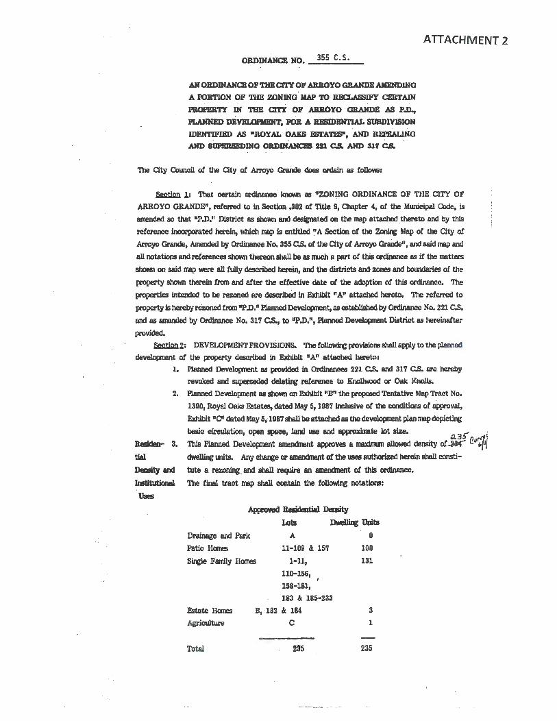
ORDINANCE NO. _3_5_5 _c_._s • __
ANOBDIHANCBOP~Cl'n' OP AB.BOYO GRAHDEAllBNDINQ
A PORTIOlf OF TJ:IB ZONING llAP TO REa.ASSIP'Y CBaTAIH . .
PBOPEB.'IY IN "l'llE c:rrr OF ABJlOYO GRANDE AS PA, . . PLANNED DBVBLOfllBNT, POJl A lU!BIDBNTIAL SOBDIVISIOH
IDEHTIPIBD AS •ROYAL. OAKS BSTA'l'!!S", AHD Jll!l'£AL1.NG
AND iluPmumDIHa OBDDfAHam m C& AND Slf C&
ATTACHMENT 2
The City Council ot the Qty of Arroyo Graiide does ordain as follows:
~ 1.1 'lbat certain ordinance known as "ZONING ORDINANCE OF THE CITY OF
ARROYO GRANDE", referred to in Section .302 or TlUe 9, Olapter 4, of the Mwlieipal Code, is
amended so that "P.D." District as showri and desJinatecl on the map attached thereto and by this
reference incorporated herein, which map is entitled ~A Section ot the z.onJng Map o! the City or
Arroyo Grande, Mended by Ordinance No. 355 C.S. ol the City ot Arroyo Grande", and said map and
all notations and references shown thereon shall be as IWch a part o! this ordinance as if the matters
shown on said map were all fully described herein, and the districts and zones and bowldaries of the
property shown there1n from and after the effective date ot the adoption ol this ordinance. The
properties intended to be rezoned are described in Exhibit "A" attached hereto. The referred to
(¥0pel'ty is hereby rez.oned from "P .D." Planned Developnent, as eitablished by Ordinance No, 221 C.S.
and as amended by Ordinance No. 317 C.S., to "P.D.111 Pl8nned Developm!nt District as hereinafter
provided.
~Z: DEVELOPMENT PROVISIONS. The tollowlq: provislom shall apply to the planned
development or the (¥0pel'ty described In Exhibit "A" attached hereto:
1. Aanned Developnent 88 provided in Ordinances 221 C.S. and 317 C.S. are hereby
revoked and superseded dele~ reference to Knollwood or Oak Knolls.
2. Aanned Development 88 shown on Exhibit "B" the propmed Tentative Map Tract No.
1390, Royal Oaks &tates, dated May 51 1987 Inclusive ot the conditions of approval,
Exhibit "C" dated May 5, 1987 shill be attached as the develapnent plan map depicting
buic circulation, open space, land use and &ppl"OXinllte lot size. 3 ~ ·
~ :> n rt1'J Besideo- 3. This Planned Develo(loont amenanent approves a maxinun allowed dermty of.act< ~" i./J tial ~units. Any~ or amenanent of the U9eS authorized herein shall comti-
Dmlity em! uate a rezoning. and shall recpre an amerdnent of this ordinance.
Imtituti1ml The fin&l tract map shall contain the t~ notations:
Uses
A(llZOYed BeQdentiel DelllitJ IA>ts Dwellilc Uni.ts
Drainage and Park
Patio Homes
A
11-109 It 157
Sup Family Homes 1-11,
110-156,
158-181,
Fstate llares
Agriculture
Total
183 It 185-233
B, 182 A: 184
c
235
0
100
131
3
1
235

64 •Note: U>ts C, 182 nnd 184 may be converted to lnrtltuUonal W!S upon approval oC
aty Council after re~ (llbllc hearq. U>t B may be converted to a public
elementary school upon approval or Qty Council after ~ public hearq.• Re9llbdi- 4. Conditions, covenants and restrictions tor the tract shall prohiblt resubdivision or any
Wiori lots.
Lot Uses
s. Lnnd use shall be co~ent with the approved developnent plan and the standaral or
the R-1,s~efamily residential dlstricttor all lots except 11-109, 15'1, 182 and 184
and Lots A, B and C. Lots 11-109 and 15'1 shall be allowed site and lot width,
coverage and yard variations ptl'S\lant to Section 9-4.611 oC the R-1 District. Lot A I
shall be a drnlnage and park-recreation site. Lots 182 and 184, Lot B and Lot Care
Intended as individual s~e family estate lots, eoch restricted to one ~e Carnily
~unit end resldentlalrelated, accessory or agricultural U9eS allowed ln the R-A
mne. Residential Agricultural (R-A) 11JeS pennltted are:
A. Single-family ~' one per buildlng site;
B. Light r~, except camerolal dairies, ccmnerclal rabbit, Cox, goat, or hog
ronm, or coomerclal chicken or poultry ranches; c. Livestock limited to two (2) animals only 'When camlned with a B.3 Dlstricl. A
like nunber or anlrm1s RBY be pennitted for additional acreage. Pen! or fencq \lled ror the hcn.llq oC such anima.19 shall be located not less than 150 teet lran the boundary oC the Residential Agricultural {R-A) District;
D. Oop and tree C~ E. One nonconmerclal guest holse; except where there ls an ~ second
residentilll dwellbv unit;
F. Mobile homes subject to the provisions of Municipal Olde Section 9-4.2405.1. A
public elementary school on IArt B · rmy be permitted . pursuant to rezoning
procedures. The YMCA and/or alternative institutional U9eS on Lots 182, 184
and B may be comidered pursuant to PD ame11ct11ent, zone charve procedures, but
In no event shall additional residential resubdivlsion be c~ousldered.
&. Architectural Review or all proposed homes on Lots 11-109 and 157 shall be
comidered alter the City Council approves this PD amendnent ilnd the tentative 1111p
ror Royal Oaks. Generally, .the preliminary Jot plans end elevations
imlolvlng "Z" and "J" lota with zero 88tbaCks on sfde yard!! for Lots 11-
109 and 157 are conceptually acceptable. Oty Council architectural
review on all lots shall include representative render~ and pivpteed Condltlom, OMmanta and Restrictions (C.C.c\!l.11), Ymlch eetablllh a developers ~
subdivision Architectural Control Cannlttee .and describes the proposed archltectlral
style (s) or theme Cor ~ to be pennitted in the subdiVtslon. Generalized
archltecturnl theme review Cor lnstltutlo..U mes shall be lnclucled with the Oty's
architectural review and shall include prcpose<I C.C.ciR.s, but not renclerqB or
drawings. The developer and/or his architectural review cornnlttee shall review each
individual bull~ plan, and the Oty will approve the deVeloper's general C.C.c!r R.
plan only.•
7. The developer shall make awllable Lot B, a school site of approxilmtely fourteen
acres adjo~ James Way, to Lucia Mar Unified School District for the District's
School future corstructlon of an elementary school under termi jointly agreed upon
Site by the developer and District ln their contractural agreement, dated March 10, 1987. Any amenctnent of the March 10, 1987 agreement shall require Oty Olmlcll
2

i '
concurrence.. All gra~, c:leveloprent and access plans of the District ond/or
developer for l'9e of the proposed school site shall be approved by the City Council.
8. The planned develqment . &hall be comtructed in ™> phases.
Phase L The initial and first phase ot planned development shall be called Phase I.
Phiise I developnent shall pemit the concurrent deve)gpment ot all public and private
irrprovements identified on-site and within the area defined ·as Phase I upon the
approved tentative tract map, plus all oft-site ~vements, excepting "E" Street.
Phase I ilqlrovement& shall include the coastruction of all patio and other homes
contained within the Phase I tentative tract map area, but shall exclude construction
of building upon Lots B, C, 182 and 184. ~. drainage and non-building lqirovermnta llVlY take plaoe upon Lota B, C, 182 and 184 a~ to approved City
plans during Phase I. BulJdlng comtructlon upon Lots B, c, 182 and 184 shall require
Cowicll detailed site plan review and approval prior to CClllm!llCelTlet.
No building pennits shall tie issued for Phase I develqmmt witil after City acceptance
of all water system lnprovemws and until the developer provides the aty CoWlcil with
a comtnaction schedule which Cauncll, in its sole juc:lgunent, detennines shall provide
for the total canpletion and City acceptance or any on- and off-site public
ilqlrovements prior to, or conci.mmt with, the CClll'pletion of all residential housing
proposed upon said schedule. · In no event shall the City Issue occupancy pennlts !or
residential buildings prior to City acceptance of all public on- and off-site
lqirovments requirecl in Phue L
Prior to ~ing Phase I developnent, the developer shall provide the Public Works
Director with a five-year car11tructlan bond euarentee sufficient to cover off-site
"E" Street public llqlrovementa to be conmucted in Phase IL
Developer is pennitted. to grade in the Phase II area ~ Phase I according to a grad~ plan approved by the Public Works Director and only tor purposes ot transporting excess till fran the Phase II area to the Phase I area. Phase IL The second and final.phase of the planned development shall be canpleted alter Phase I. Phase 11 develqment shall pennit the concWTent developnent ot all
public and private irqlrovements identified on-site and within the area. defined as
Phase II upon the approved tentative map, pWs off-site "E" Street. Phase II
inl'lrovements shall Include the ccmtructlon of all homes contained within the Phase II
tentative tract l!Vlp area. . No ~ permits shall be issued for Phase II dewlqm!nt until the developer
provides the City O:luncD. with a ocnatructicn llCheclule which Council, in its &Ole
jlqement, detennines shall provide tor the total ~tion and Qty acceptance ot all
on- and off--slte public Improvements prior to, or concurrent with, the ~tlon or
any residential housing~ upon said schedule. In no event shall the Qty ~
occupancy pemits for residential bul1dqa prior to a~ acceptallCO ot all public on
and otf-slte lnt>rovementa 1equlred in Phase IL
lapove- B. lqnwment .Bam
A. Standtird specifications for Pubpc Works Constnaction. latest edition, and all
applicable Clty Standard PJates shall be the project specifications except as
noted otherwise on the approved ilrpovement plarw. 'Ille llrpovement plans
tor the project shall be prepared by a Calitomla Registered Civil F.q:ineer
and shall be approved b,y the Public Works Department prior to recorclation ot
the final mop.
3
65

B. Pl.nm shall include, but not be lhnlted to, gra~, drainage, sewer, water ond
utility lntx'ovements. In addltlon, a rmster utility plan soon be sulxnltted
showing the layout and location or oil the on-site and o!f-slte utility facility
hr(lrovement or the project, Including water, sewer, drainage, ga, electric
and ccmnunlcatlon utilities. The 1111Ster water, sewer and drainage plan
shall be sul:xnltted and approved prior to presentation or other fnix'ovement
plans. The plans BUl:rnltted ihall also Include aonstrucrtlon ccst estimates,
plan check ree:sr soils reports and all pertinent ~ design
calculatlom. The final nap nay not be med with the aty QruncU unless all
said . lrqlrovement plam have . been approved by the PUblic Works
Department. All required rights or 'PIDY or easements shall be dedicated to the aty prior to, or COllCll'n!nt with, sul:mittals or the t1nal map to the Oty
Colmcll (or approval. 10. "Water, Sewer, Street Tree and Other Nile UtDitles
Water, Sewer, A. All lots shall be provided with servfc!e Cran aty water supply. This system
Street Tree and shall tie into the backbone S)'Stem comtructed by Rancho Grande and the
Other l\tiic Royal Oak F.states developers wD1 be required to pay any e 1e11ts with the
Utilities recordation or rinal nap(s) • .
B. The subdivider shall Install water lllllm, fire hydrants and service laterals in contorrmnce with the Water Department Standard Design and Specifications and approved plans. Fire now u specllied by the Plre 01let and approval or the Pl.lbllc Works Department ahall be aYllllable prior to obtaining any bull~ permits.
C. All lots shall be served with City sewer. D. In oddltion to speci!Jc easements shown on . the tentatlve n11p, a six Coot
eosement alollt and adjo~ local. streets and a ten toot easement along and
odjoinlng collector streets Bha1l be reserved as a street tree and public utfllty
easement. Lot 11. UJt ~
~ A,, Developer shall provide the tinal grades and finish or residential lots.
C.C.&R.'s shall advise future property owners that no further grading shall
be pennltted, other than minor detail grading work which requires City
permit.•
B. Lots 220 UU'ough 226 shall be developed in natural terrain.•
c. Grading or Lots 227-232 and Lot 183 shall be redesigned to renect natural
terrain and dnllnage pattems and confonn to Cl'CJm slope design criteria.•
D. Slope banks at the rear or Lots 187-191 and the l!llOUth aide or Lot 20& Bhall be
designed with variable slopes or 3 to 1 or greater and landscaped in accordance with approved plan designed by a landscape archJtect and
imtslled by the subdivider and maintained us part or the side or rear yards or the Involved lots, to burler residential developnent frcm adjoining future
develqment on County property.•
.E. Lot width to depth ratio exceptiors are approved for those portions or Lots
127 through 130, which extend Into the tree preservation assmment area.
The rear portion of Lots 127 ttrough 130 shall be designated and recorded a5 a
scenic easm1e11t. • F. Grading or Lots 127 through 134 shall be modified to pad the front 125 foot
4

with the rear slope banks reduced to 3 to-1 or greater.•
G. In developnent o! patio homes, the tentative map layout for retaining wlllls is
conceptual: When final map, &M/or architectural review ot construction
plans tor structures are resolved, additional walls imy be pennitted as required.
No wood re~ walls which intercept slopes at property lines shall be
pennitted.
12. A.bendoned Well-Head
A. The developers and the independent soils e~ shall inspect the site,
rrcnitor grading and, if an abandoned wellhead is found on-site, shall provide
plans and, upon approval by the Qty, properly &eal and cap said well.•
13. Geoerul Drainage, ~ and Pmiioll Cciotial
Geoenl A. Cail>lete grading and drainage plans shall be submitted to and approved by the
Public Works Departrr.ent prior to any final map. Prior to any site grading or
construction, an erarion control plan and program shall be submitted to and
B.ppl'Oved by the Public Works Departnent, said plan and program to address
specific tell{JCll'8ey and pennonent eroaion contral meosW'eS 11SSOCiated with
the projeet. • ·
B. The subdivider shall pay tor a qualltled independent eremeeriq: co~tant selected by the Qty to review gradir.r and drainage ilr1x'overrent pluns,
inspect the slte prior to and during all imjor site preparation grading. The
subdivider's soil ~ &ball wtxnit tests and reports to certify all Jots as
ready for CONtruction prior to issu&nce of building pennits thereon.
(Further site or lot grading shall be noted on the final mop os prohibited
except for ~ and driveway purposes specifically approved by the City
pursuant to subsequent pennit tl(lplicatkins.)•
C. Detailed site gracliqt, drainage J.nt>roveaent and erosion control plans for the
entire subdiWion and oft-site llqxovements, inc1ud1ng Interim grading of any
lots, if proposed, shall be submitted to and approved by the Qty Public Works Director. QualWed Independent consultants lhall be paid tor by the
subdivider but selected by the Qty. Such shall rev1ew saJd plans and inspeet
the grading, 'Illese plans shall be approved prior to any ~ pennits for
any phased developnent. Site grading lhall be restricted to the Spring or
Slll1ller season, April 1st tllrouGh October 31st, wlless otherwise approved by
Council; and require replan- tor enlSior1 control in accordllnce with plans
ptepan:d by a landscap(i architect, v.tllch will be ~ted dur~ October
Noveid>er and nfntained during at least one wet season, Noverd)er through
March, followire gr&dq to assure mlnlnun siltation.•
H. 14t A llDd Via La llarra.- Dr8lllap S)9tem
Lat A and A. 'lbe developer shall . be l'8Q1ired to design and aanstruct a stonn drainage
Via La Bunmca retention facility and other draillap and park facility on Lot A and upon the
Drainlp S)4stAlll Qty-owned adjacent ott-slte (l'Operty as recJired by the City C'.ouncil.
Jn\lrOvement plans and contr~ m.wt be approved by the Public Works i . Director prior to constNctlon or gr~ tor these facilities.•
B. 'lbe slope bank behind !4ts 34-40 shall be part of Lot "A", the proposed
drainage detention basin; the slope bank shall be mved westerly to enable a
drainage swa1e on site ~ the east tract boundary into the basin. Slope
bank, swale and basin Jand9caping shall be deslgned by a landscape architect
5

Lot 182
Doth
Dralnnge
SystmB
nnd installed by the subdivider,• . '
C. The City-owned Via La Barranca drainage property MIS accepted by the aty
for both park and drainage ~. Developer's coratltants shall wtxnit
specific dralnoge landsce~ plam ror Lot A, the ndjo~ City-owned Vin
La Barrnnca property and dowistream dralnoge lines or other nitlgntlng
meosures toW8l'dl orf.·slte cnlnage deCiclencles, wl1el'e neeessary, to the
Public Works Director ond Parks and Recreation Director. The t"'10 directors
sholl review and arlalyze such pJam to detennlne the adequacy or such plam
tos
l) mitigate or reduce current"and projected noodi~ or the streets and areas
below the current Ctty drainage facility and works, . and;
2) mitigate or prevent any further n~ or the streets and areas below
the ctnTent Qty drainage faclllty and works to be cal8ed by the planned
developnent; and;
3) provide recreational opportunities upon the site to the fnmedlate
neighborhood; and;
4) . how those propaeed recreational opportunitll!S upon the site COl'lt>fJJ'e with
opportunities to be provided by the currently approved park developnent
plans or the Parks and Recreation ~Ion, and;
5) provide security and satety measures and durable and substantial
ifTt:Jrovements which can be elficlenUy and adequately rmlntalned by the
Oty.
The directors shall sutmt a Mitten report or their findings and the
proposed specific plan to the Ctty Omncll "Which shell detennlne prior to
the lssumtce or any grading permits, the Mure ownership and
responslbWtles tor Lot A, the U98 or the Ot)"'OWMd Via La Barranca
drnlnege and specific park and drnlnsge plan.•
15. I.ct 182 Drainage s,stan
A. The developer shall be required to design and comtruct a stonn drainage
retention raclllty and other drainage on Lot 182 as requJred by the Ctty
O>uncll. llftX'Ovcment pl.am and contracts rrust be approved by the PUblic
Works Director prior to C!DrStructlon or grading for · these facllftles. • ·
B. Developer's consultants shall sutxnlt specific drainage and landscape plans for
drainage on Lot 182 to the Public Works Director. The director shall review
and analyze such plam to detennlne the adequacy or such pl.am to: a) mitigate or reduce current and projected floodi~
b) provide security and safety measures and durable and sumtantive ·
improvements "Which can be efficiently and adequately rmintaJned.
The director shall sul:mlt a written report or his find~ and the proposed
speclllc plan to the Qty Council 'Which shall detennlne, prior to the lswance or any grod~ permits, the future CMltel'Sliip and responsibilities for the drolnage
facilities and the acceptability or the proposed specll'lc drainage plan •• 16. Both Drainage Systma. I
Regarding stonn drainage retention capacity within lot "A" and the adjoining City
drainage retention basin, and on Lot 182, evidence or orr-stte easements and design solutions acceptable to the Ctty shall be sut:mtted to and approved prior to gradi11r or concurrent v.1th final IT'8p Improvements plans.*
6

The subdivider shall bond for, provide and restore all on-site and off-site drainage
detention basins capacity, rcm>ve siltation Whleh occurs and provide general
DMl.intenance ot all drainage facilities ~ the three-year period following
acceptance ot subdivislOn iapovementa by the Qty or f~ site preparation
gr~. Thereafter, the Qty shall assume total IJMl.intenance respoi&ibilities for same
without benefit ot maintenance asses1111mt district.• 17. No Parkirg
A. "No Parking" signs shall be iMtallec:I on Halcyon Road in front or U>ts 110-
113, 123and178-181, and, U neceaary, a street tree and landscaping control
easement shall extend Into the 201 fl'Clllt yard ot these lots to assure odequate
sight distance at the intersection with "F" Way. "No Parking'' signs shall be
installed on Halcyon Road in front ot lDt B. •
Park an:I Signll1 Pees
A.· The developer shall contribute fwm puniuant to the City's park in-lieu fee
and the signal fee orclinances to provide for ott-site park and recreation and
tratfic iqx'ovements. •
Sbeet 19. Street Names
Names A. Street nam!S acceptable to the Fire, Police, Public Works and Planning
Departmerits shall be sutmltted prior to or. concurrent with f'inul mop and
in41rovement plam. (List of pcmlble names available flan Planning
Department). Halcyon Road shall be renamed also.•
Off-site 20. Oft-site ID{¥ovemeelll
lopovmeots , A. Any right of way or property 8C(J.lisitiom necessary to aCCOlllilish off-site
. liqlrovements recJ.lfred as part of this planned develqmmt shall be
acccmpJJshed by or exclusively at the expeme ot the developer.•
21. Sbeet '1\eal, 1.anclntpi. and Qllll:zals
A. A detailed on..; and off-site Jandscapq plan, includirtr materials
and irrigation plam for street trees and other specltic areas ot public
concem (~segments of James Way and Halcyon Road); shall be sutmtted
to and approved by the Parka and Recreation Dlrector, prior to any final map
approval. · A nuter fencing plan, ~ unilonn design along public
streets, shall be part of the detalled landacaplrg plan..
B. Developer shall plant all ~ materials accarcllng to the approved
1andsc:aplrg plan, and shall nlntain and replace, when necesary, all plantings
for tv.o years after Qty acceptance ot phased public iapovements. •
C. A water conservation program, particular)¥ including drought resistant
landscap~, shall be provided by the developer COtlCl.ITeDt with other utility plans, such u nmter water and sewer plam andapeclfic drainage and park and
street tree p1am. •
D. Street trees aM/or unilonn alopo bank plantlrg on, or near, street frontages
shall be the maiiltenance respomiblllty of. the lot ON.er, Wlless specifically
acce~ted by the City, In addi~ to specific easements on-site shoM1 on the
tentative imp, a six-foot easement, ~ and ~ local streets, and a
ten-foot easement, ~and adjoining collector streets, shall be reserved as
a street tree and pub1lc utility easemenV
'l
69
Stnnderd 22. Standnrd Qty Olndltions
Cly "Standard O:lnditiom or Approval" !or Tentative Ma(S in the City or Arroyo Grande
Olnditiom ore hereby included os it speclCically itemized herein.•
&rplm 23. &JrtiU9 ~ Property The cleveloper shall note resubdivlsion er the previously tt:corded parcel nap Involving
the property nncl note the abnndorment of any surpllB rights or way or eesements which
are to be eliminated by the final nap of Tract No. 1390, •
Cm.IJation (street) System I
The followirG off-site ond on-site street lrq>rovements are to be designed to the
approval or the Oty ond comtructed or ~ prior to final mop approvals nnd
occupnncy permits for the oppropriate phase of this planned development:
A. West Branch Street
1) C.onstruct ond lnllrove West Branch Street from Its temdnus at the South
C.ounty Regional Center easterly to a connection through Vernon Way
West Branch St. intersection odjolnlng the C.ainunity Center to a rmnJnun of tv.o lo.nes, lnclu~ bike Janes on both sides, with concrete curb and gutter on the
freewny side and ~ asphaltlc concrete curb on the cpposite side (unless penmnent concrete curb, gutter Md/or sidewalk mt) from the
South County Regional Center paving end through the Vemon Wey Street
Intersection in order to catt>lete a street connection belMen Onk Purk
Road and Grand Avenue and confonn emting street eectiom with new
construction. West Brnnch Street Improvements shall Include provisions
for left and/or right tum lanes at approeches and intersectlom with
Brisco Rood, Halcyon Road, "E" Street and Vemon Street. Grading
shell confonn to the ultimate road section adopted in 0ty Standards for
West Branch Street, 165-Ag.•
Haleyon
Road I
2) The Cty shall be respomlble for relocating all aty sanitary sewer lines
which 1111.y be necessary to aooamoclate new dewloper comtructlon in the West Branch and Vernon Intersection. Whatewr water line
problen"B have to be corrected, between the South OU!ty Regional
Omter easterly to a eonnectlon through the Vemon Avenue lntmieatlon
odjolnl~ the Omrl.lnlty Center CX1 West Branch Street, wD1 be done by
the City, up to a cost or $25,000. It the costs are more than $25,000, the
developer will pay the extra costs.• 3) The developer shall relocate any other utDlties, Ir necessary.
Developer shall acquire nece9sary right or way at Vernon and West
Brnnch Streetll f1U11 Cal Trans, prior to construction. The City soon
provide developer with Cly-owned right or way at Cl::rrm.lnity O!nter at
no cost, prior to constructJon. Developer shall not be responsible for
constructing a ~wall !or the Calmmlty Center parkJng lot on
West Branch Street as a result ot street comtructlon, nor repla~ lost
Ommmlty Center par~. (Phase 1)•
B. Halcyon Road
1) Construct and fn1'l'o've Halcyon road between West Branch Street and
James Way, 40 !t. curb to curb in a 52' right of ~Y· lrr(>rovements
include wfdenlngs and frontage inllrovem?nts across portions of Col.mty property.•
8
. i

.ilmes Way
2) Omcrete curb and gutter shall be installed on the MSterly trontage of
Halcyon Road between West Branch Street and the southern tract ·
boundary where pavement widen!J1:. is required. A terq>Ol'IU'y asphaltfo
concrete curb will be irwta11ed on the easterly frontap or Hal~oo Road
between We5t Branch Street and the southem tract boundary.•
3) Access rights to Halcyon Boad fl'Cllll Lots 94-109 shall be offered to the
city to prevent drivewa)'ll directly coto this residential callector street,
and the fencire eswj/or landscaping ot the slope banks abutting Halcyon
Road shall be desl&ned by a land.wipe W'Chitect, installed by the
subdivider concurrent with street frontage ond shall be maintained as part of the side or rear yarm ot Involved lots.•
4) The right ot vey tor the northem extentlon ot Halcyon road, on which
Lots 1-10 front, shall extend to the north tract boWldary and an access
denial strip shall be Offered to the Clty to control said connection until
and unlem approved by the Qty O:iuncll. Landscapiq: shall be designecl
by the subdivider and Installed concl.l'Nnt with construction ot Holcyon
Road inllrovements alter design approved by the Parl<S and Recreation
Director and naintained by the Clty. (Phase l)•
C. .iimes Way
l) James Way shall have an ultimate width ot 44 feet of dri~ surface
between concrete curb and gutters (incl~ gutter pam) with six-foot sidewalks (including curb width) on both sides. The irrproveaent shall be
centered within a 64 foot wide right of way. Street iqlrovements shall
include all necessary Lltilities, ~cable TV, telephone and sewer, 1n con!onlWlCe. with the approved master utWty plan for the subdivision.•
2) Jntx'ovement requirements between the develcprent east and west
property boundaries shall conform to the ultlnvite ilqlrovement section.•
3) ln\:lt'Overrent requirements westerly ot the tract to Rancho Parkway shall
be limited to installation ot a. v.ater main, ~trench patching with a
one-Inch pavement overlay to be appUed on the full lnpoved width or the
street ~ at the time the water main ls Installed.•
4) Jn\>rovtm!nts required on the length of Jomes Way easterl:ii or the tract
shall be limited to contonnance to the exis~ dri~ lanes and any
drainage ilq>rovements deemed apprq:riate to prevent erosion of the
appropriate rights of way propcsed for use at the time carmniction
cannences.• 5) Jn\>rovements ot James Way northerly of the subdivision (fronting on the
James parcel which lies outside the corporate lfmltso! the Qty) have been
volunteered by the developer tor COllStructlon Uiat contonm to the
ultimate section ot road between the east and west tract boWldaries.
This lrrpn>venent Is therefore comldettd a corw:lltJon to the approval of
the~.·
6) Access right to James Way Iran Lot 1 and Lots 6-34 shall be offered to
the City to prevent driveways directly onto this collector route. The
t~ and lancBcapq of uime ~lots abuttq James .Wayshall be
designed by a landscape architect and lmta1led by the subdivider
concurrent with street frontage lrrpovements and shall be imintaincd as
9
?1

Other
streets
part or the side or rear yards ot Involved Jots. CPhose I)•
D. Other Streets
1) Conmruct and Jntirove "A", "B", "C'', "D", "E", AND "F" Streets and
Halcyon Road north or James Way- (401 curb to curb, 61 sidewallcs both
sides, 52 rt. right or way). Construct and irrtJrove Halcyon Rood, A, B,
C, and F Streets concurrent with Phase I. Ontnlctlon and tnprovement
oC . "D" and "E" Street nay be deterred LDllll Phase II,• 2) Comtruct "E" ~treet across the South County Regional Center property
southerly to a connection with . the propaaed West Branch Street connection.•
3) '111e right or way tor the easterly extemion ot "P" Way, to enable pmsible
Mure connect.I.on with MDler Way, shall extend to. the eastem tract
boundory and an access denial strip ottered to the aty to control said
connection until and l.llless approved by the Qty OJuncD. An
emergency aC!C!eSS gate lhall be designed by a civil ~ and/or . landscape architect and inrtalled by the subdivider eoneurrent with
. comtnictlon or "F" Way street ir{lrovements after design approved by
25. SidewaDcs
the Public Works Director. '111e gate shall be mdntalned by the Oty • . (Phase I)•
SideMiks A. Six-root sidewalks shell be required In the proposed developnent on both sides
or James Way, Halcyon road," A", "8", "C"', "D", "E" ond "F" Streets, except
ror the rrontagesot Lot Con Halcyon Road, and Lots 220-232, 183and156 on
"D" Street.*
B. A short segrrent or slclewalk shall. be COl'Btrueted on the westerly rrontnge or Halcyon road southerly of the tract boundeey to a point where the developer
sholl coordinate with St. Pa.trick's School a stairway access between Halcyon
Road end the school parkl~ lot.•
Tree 26. Tree naa nrtion
A. A. detailed tree preservation plan and program, Including an Inventory or existi~ trees 800/or groves shall be prepared by a qualified professional,
including nnps or the species, size and location or all trees, with respect to lot
lines ond proposed bull~ areas on each lot (excllEive or those located
within the tree preservation e&'lel'llel1t areas), and submitted to the Parks and
Recreation Director prior to tlnal map or ~ approval. The Parks and
Recreation Director shall reeamte1id the designation and preservation or
"landiBrk trees or groves"·as provided by Ordinance Ntnlber 333 C. S., and
such nnp shell be ClDl1'pleted by the developer and eonsidered by the City
Q)tmcll prior to any gradfrv or tree trlmnlng or removal, Issuance or grading
pemdts or rinal nnp approvals, whichever occurs first.•
1} The Oty shell designate all o8k trees contained within the two tree
presel'Vlltlon easements identit'led upon the tentative np as "Lenctnark Groves" in accordance with proYlslons or City ordinance Nllltler 333 C.
s. Furtherrmre, the OJUncl1 shall consider all other trees on-site ~
off-site tor "Lendnark Tree" designation in aCC!Ol'dance with all
provisions or Ordinance Nmtler 333 C.S. prior to the Issuance or any gra~ pennfts or final tmct rrep approv&ls, whichever comes tlntt. The
10

developer shall caJ{lly with all 1¥'Qvisions ot Ordinance Nlllt>er 333 C.S.,
except that developer Diily replace authorized tree removals in 24'
containers rather than 481 containers, which ls 1¥'Qvided for in Orclinance
NLl!iler 333 C.S. and replacement trees need not be oak trees it so
detemined by the Parkl and Rocnatlon DINctor. 'lbt Director may
authorize a replacement tree ratio from two-to-one to five-to-one as a
variance fran Orclinance N\lllber 333 C.S. • 2) Scenic and tree pre&el'Vlltion easements fOl' the two oak groves shall be
recorded by the developer after approval by the Qty Attorney and Porks
and Recreation DJrector. Such easements shall COlqlly with State law,
include 1¥'Qvlslans ot future tree maintenBnce and protection os
contained in Ordinance Nunber 333 C.S. and bind the o~, heirs and
~ ot all lot owners overlapping the easeirents to such tree
ownership, nintenance and 1¥'Qteetion forever.•
Similar recor<linss are recJlired tor any other tree detennined by Council to be
a "I...ancmark Tree."• B. The tree preaervation Ulll1'8nta lhawn on the propmed tentative tract mop
shall be offered to the owners, heirs and 8S9igrls ot all tract owners, and it shall
be stipulated by recorded C.C. and R Is that tree renoval, gradi~, fencing or
~shall be prohibited in these easemmts unless specJfically approved by
the City Councl1. Additional recorded scenic easements with similar
re:strlct!Qm shall be applied to the steep slopes on Lots 127-130. •
C. Developer shall grant to the City a recordeble pennonent open space easement
and tree preservation easement ~ and restrictiqr the use of the
rear portions ot Lots 138 through 140, 220 through 228 and 232 and portions ot Lot Canel Lot 182, all asrilore apeclflCally depicted on the approved tentative
Dlllp ot Tract N~ 1390. 'Ille first grant deed to eacl'I ot said percels shall
specifically refer to both ot said easermnts and their recardation, lUlCI shall
turther note that the ellSl!mWs are enforceable not only by the owners of the
affected lot but also by the Qty and by all other ~ ot property in Tract
No. 1390. No such easermnt shall be amended, released, abllndoned or
tenninated by the aty except by specific amencinent o! the Royal Oaks1
planned developll!nt zoning ordinance or suocesaor ordinances thereto.•
27. BenM!oo .Ap(llovirg Tentative Trect Map
. Asterisk A. All paragraph9 contained within this ordinance, followed by an asterisk(•),
shall be incorporated verbatim as condltlool to be attached to the tentative
tract map.
Seetioll 3: This ordinance shall be ln tun force and effect thirty (30) days after its passage;
and within fifteen (15) days after its passage, it shall be published once,
together with the names ot the Council Menbers ~ thereon, in a
neW>paper ot general circulation within the City.
11
·73

On motion of Cbuncll Menber Moots
the following roll call vote, to wit: seconded by Council Merrt>er Porter Md on
AYES: Council Members Moots, Porter and Mayor Mankins NO~: Council Member Mi 11 is
ABSENT: Council Member Johnson
J•
the fOl'egOq ~was passed and · adopted on this . 19th day or _M_a_Y __ ,. 1987•
Attest: 1~ a .. ~ CITY CL K
I, NANCY A. DAVIS, City Clerk of the City of Arroyo Grande., County of San ~uis Obispo, State of California, do hereby certify that the foregoing Ordinance No . 355 C.S. is a true, full and correct copy of said Ordinance passed and adopted at a regular meeting of said Council on the 19th day of May, 1ga7.
WITNESS my hand and the Seal of the City of Arroyo Gr.ande affixed this 28th day of May, 1987 .
CIT~
12

"'II I
0
;c ., n c -... c ~
EXHIBIT A .VC17tMI tY DIE .r..:wt.u:" AV IY l'ltY C/Tr IV~ (;«(IA£
AMMJf.D ~r Ofa!V..UC/' MJ .M~ CS tT M VFT IY Mfl1/f1 &MNA'"
liOYAl OAK.S £.$TATES
·~ M~
,,,1·
ZONING 1. lot A zoned PD Drainage and Park 2. lot C zoned PD Agriculture 3. tots 1-10, 110-156, 158-181, 183 and 185-233 zoned PD Single 4. Lots 11-109 and 157 zoned PD Patio Homes 5. Lots 182, 18~ and B zoned PD Single fami l y Estate Homes Hay 5. 1987
family Homes
"'II I
0
,., "' .,,-.... :z >I:> -4 .... .... "' :c "'I §>~ ,,,_ "'!<
"'II ,, I I
I:> 0
0 :r~ ;.. Oz > 3:n ,., .... z "' "' >
C1 "'I "' ~ "' ;::: ___ ,, < >
;..
""
... I
0
:r . .,, o-3: z rnn "' .... '" i
I 0
"'II
~ ;; ::c 0 3: ,., "' I ·-
l'Tl )C ::r ..... CT ..... r+
:i;
0 , c.. ..... ::I
"' .::i n II>
w ui ui
.n VI .
1\..
-:l c.n

PLANNING COMMISSION MINUTES MARCH 3, 2015
ATIACHMENT3
Russell Story, NSA, representing Verizon Wireless, responded to questions from the Commission regard ing the proposed project.
Chair George opened the public hearing. There were no comments received and the public hearing was closed.
Ind ividual Commissioners provided the following comments for the proposed project: expressed concern with the adjacent property owner being aware of the proposed project; a notation that no other carriers can be on the pole without City approva l; it is safer to have the equipment above ground; equipment needs to be protected; the equipment cabinet shall be relocated behind the pole; and can support the ARC changes.
Action: Commissioner Martin moved to adopt a resolution entitled "A RESOLUTION OF THE PLANNING COMMISSION OF THE CITY OF ARROYO GRANDE APPROVING CONDITIONAL USE PERMIT CASE NO. 14-008, APPLIED FOR BY VERIZON WIRELESS, LOCATED ON VALLEY ROAD". Commissioner Keen seconded, and the motion passed on the following roll call vote:
AYES: NOES: ABSENT:
Martin, Keen, Fowler-Payne, Mack, George None None
9. NON-PUBLIC HEARING ITEM
9.a. CONSIDERATION OF PRE-APPLICATION NO. 14-006; LOCATION - RODEO DRIVE AND GRACE LANE; APPLICANT COLMER CONSTRUCTION; REPRESENTATIVE - WAYNE COLMER Associate Planner Heffernan presented the staff report recommending that the Commission review the conceptual plans and provide comments to the applicant.
Wayne Co!mer, applicant, presented the proposed project and acknowledged water availability as a potential issue given that this project requires a General Plan Amendment to allow an increase in density.
Jeff Emrick, Garing Taylor & Associates, responded to questions from the Commission regarding the proposed project.
Individual Commissioners provided the following comments for the proposed project: if the street is not full width, guest parking should be provided ; create useable open space; concern with the number of residential homes (18) and would like to see a less intense development; suggested eliminating Lots 17 and 18; noted the road is narrow at Lots 14 - 16; asked if there has been a neighborhood meeting; suggested a viewshed review process as neighbors do not want their views blocked; the lots are too small; lots should be 6,000 square feet and 60' wide; property is too dense; not in favor of a lot of grading; do not want vehicles obstructing the sidewalk; would like to see the environmental report (initial study); and not concerned with the open space as there is a park in the area.

PLANNING COMMISSION MINUTES MARCH 3, 2015
PAGE4
Kirby Gordon, property cwner, does not feel there will be an environmental issue with the proposed project and views will not be impacted.
Chair George opened the public comment period.
John Spencer, Callado Corte, requested extensive notification to go out to the neighbors, more than the 500'; and questioned why drastic changes are being made as the proposed project should follow what the City has planned.
Beatrice Spencer, Callado Corte, expressed concern with changing the Code to allow this type of high density.
Hearing no further comments, Chair George closed the public comment period .
10. NOTICE OF ADMINISTRATIVE DECISIONS SINCE FEBRUARY 17, 201 5 This is a notice of administrative decision for Minor Use Permits, including any approvals, denials or referrals by the Community Development Director. An administrative decision must b I d II d f . b h Pl . C b e appea e or ca e up or review y t. e anrnnq omm1ss1on y a ma1onty vote.
Case No. Applicant Address Description Action Planner
ARCH 14-009 Ten Over Studio 307 E. Branch Fai;:ade modifications to the A M. Downing Street eastern tenant space of the
fo rmer JJ's bui lding
11. COMMISSION COMMUNICATIONS Chair George reported that the new Commissioners have not been added to the City's website .
12. STAFF COMMUNICATIONS None
13. ADJOURNMENT On motion by Commissioner Keen, seconded by Commissioner Martin and unanimously carried, the meeting adjourned 8:45 p.m.
ATTEST:
DEBBIE WEICHINGER LAN GEORGE, CHAIR SECRETARY TO THE PLANNING COMMISSION
(Approved at PC meeting April 7, 2015)

Minutes: City Council Regular Meeting Tuesday, April 28, 2015
ATTACHMENT 4
Ms. Thompson thanked the Council for selecting her as the City Manager, stated she is looking forward to working with the Council, staff, and community in order to maintain and preserve this wonderful community.
Mayor Hill called for a break at 6:55 p.m. The Council reconvened at 7:10 p.m.
11.a. Consideration of Pre-Application No. 14-006 for a 13-Lot Residential Subdivision; General Plan Amendment, Development Code Amendment, Tract Map, and Planned Unit Development; Location - Rodeo Drive and Grace Lane (APN 007-011-041 ); Applicant - Colmer Construction; Representative - Wayne Colmer.
Mayor Hill declared a conflict of interest on this item due to ownership of real property near the project, stepped down from the dais, and left the room. Mayor Pro Tern Barneich took over as Presiding Officer.
Associate Planner Heffernan presented the staff report and recommended that the Council review the conceptual plans and provide comments to the applicant. Staff responded to questions from Council.
Wayne Colmer, applicant, thanked the City for the pre-application process; acknowledged the need to demonstrate water offsets at 2: 1, provided a presentation of the project; and answered questions regarding the increased density; height of retaining walls; height difference between one and two story homes; and lot sizes.
Kirby Gordon, property owner, commented on the history of the parcel , the proposed realignment of Grace Lane within the project which will meet Circulation Element objectives; commented on smaller lot sizes and leaving more natural open space.
Jeff Emrick, representing the applicant, commented on smaller lots using less water and that a water analysis will be completed to mitigate water use.
Mayor Pro Tern Barneich invited public comment. Speaking from the public were: Patty Welsh, Arroyo Grande, regarding the proposed project as it relates to lot sizes, additional traffic, water pressure, parking and water use; Bob Miller, Via Vaquero, expressed concern about negative impacts to property values in the surrounding area and prefers development that is more commensurate with the existing home and lot sizes, and requested the fence line along the back of Rancho Grande properties be preserved; Mike Furman, Via Vaquero, expressed concern about smaller lot sizes, and preferred larger lot sizes with larger homes; Beatrice Spencer, Arroyo Grande, expressed concerns about negative impacts to property values of existing homes, smaller lots and smaller backyards, and retaining wall heights; John Spencer, Arroyo Grande, requested the notification area be expanded for the project; Colleen Martin, Arroyo Grande, opposed the proposed project with 13 units, commented on street width and parking for residents, and stated the project should meet the current General Plan density requirement for seven homes. No further public comments were received.
Follow-up questions from Council ensued regarding on and off-site parking within the proposed project; retaining walls ; zoning and land use designations; ADA requirements for sidewalk width; and publ ic notification regarding the proposed project.

Minutes: City Council Regular Meeting Tuesday, April 28, 2015
Page6
Council comments ensued regarding previous rezoning for the Grace Lane project; water impacts and the need to justify additional water use; that the increased density is a good use of the land if the water issues are resolved; recognition that property values are different based on when existing units were built; that the project is adequately parked; that more information is needed on the fence issue; support for the proposed retaining walls ; support for the expanded public noticing that took place for this type of project; acknowledgement that the project does not meet General Plan requirements for density and water availability due to the additional units proposed; support for the proposed street and driveway parking and the two units off of Grace Lane; that this is not a transitional project and should have homes similar in size with the existing neighborhood; does not support proposed water neutralization calcu lation methods for additional units; concerns about drainage and percolation; support for a 7 unit project with no additional water requirements; concern with a higher density project which is not consistent with the Land Use Element; that two-story homes are inconsistent with the existing neighborhood development; concern with impact on existing home values; that a single family low density project would be better considering the water issues; that this is an in-fill project that could provide more affordable homes by design and would be desirable for families, although the water requirements remain a concern ; appreciation for saving the Oak tree; and that a water study will be important.
There was no formal action taken on this item.
Mayor Hill returned to the meeting and took his place at the dais.
11.b. Consideration of Request to Install Additional Stop Signs at the Intersection of Le Point Street at McKinley Street.
City Engineer Horn presented the staff report and recommended that the Council: 1) Direct staff to obtain a consultant to complete a Traffic Circulation Study that will review alternatives for Crown Hill/Le Point/McKinley neighborhood; 2) Approve the installation of interim stop signs on Le Point Street at McKinley Street and a stop ahead sign between McKinley Street and Highway 227 and reevaluate performance during circulation study review; 3) Direct staff to work with property owner of 207 McKinley Street to trim vegetation on property within sight distance triangle area; 4) Direct staff to restrict parking on areas of Le Point Street and McKinley Street; and 5) Direct staff to develop a Policy and Procedure for staff and residents to follow to request and evaluate traffic calming measures.
Mayor Hill invited public comment. Speaking from the public were Patty Welsh, expressing concerns about the speed bumps on Rodeo Drive, and that a traffic study should be conducted during peak school hours ; and Heather Jensen, Arroyo Grande, stated she was pleased that staff is working on a circulation plan for this area, commented on increased traffic on Le Point Street, and suggested that future public notifications be sent by regular mail. No further public comments were received. Action: Council Member Harmon moved to: 1) Direct staff to obtain a consultant to complete a Traffic Circulation Study th8t will review alternatives for Crown Hill/Le Point/McKinley neighborhood; 2) Approve the installation of interim stop signs on Le Point Street at McKinley Street and a stop ahead sign between McKinley Street and Highway 227 and reevaluate performance during circulation study review; 3) Direct staff to work with property owner of 207 McKinley Street to trim vegetation on property within sight distance triangle area; 4) Direct staff

Project Site Photos
Rodeo Drive Subdivision (VTTM 16-001 & DCA 17-001)
View from Rodeo Drive, looking west
ATTACHMENT 5

View from Grace Lane, Looking south

CITY OF
ATTACHMENT 6
INITIAL STUDY/
MITIGATED NEGATIVE
DECLARATION
Project Location
Development Code Amendment 17-001 Vesting Tentative Tract Map 16-001 (Tract 3079)
Rodeo Drive/Grace Lane
February 2017

INITIAL STUDY MITIGATED NEGATIVE DECLARATION
DCA 17-001; VTIM 16-001
February 2017
Project: Development Code Amendment 17-001 & Vesting Tentative Tract Map 16-001
Lead Agency: City of Arroyo Grande
Document Availability:
• City of Arroyo Grande Community Development Department 300 East Branch Street Arroyo Grande, CA 93420
• http://www.arroyogrande.org/
Project Description:
The proposed project involves amending the Arroyo Grande Municipal Code to allow additional residential units within Planned Development 1.3 and subdividing a 7.52-acre property into seven (7) residential lots with an offer of dedication for roadway purposes. Residential lot sizes range from 0.58 to 1.32 acres and the dedication is 0.28 acre.
Summary Document Preparation:
Pursuant to Section 21082.1 of the California Environmental Quality Act, the City of Arroyo Grande (the City) has independently reviewed and analyzed the Initial Study and Mitigated Negative Declaration for the proposed project and finds that these documents reflect the independent judgment of the City. The City, as lead agency, also confirms that the project mitigation measures detailed in these documents are feasible and will be implemented as stated in the Mitigated Negative Declaration.
Teresa McClish, AICP Community Development Director
Kelly Heffernan, AICP Associate Planner
Date
Date
Page 2 of 41

INITIAL STUDY M ITIGATED NEGATIVE DECLARATION
DCA 17-001; VTIM 16-001
Table of Contents:
February 2017
lntroduction ................................................................................................................................................... 5
Introduction and Regulatory Guidance ............ ........... ... ..... ..... ............ .......................... ........ ............... .... 5
Lead Agency ........................... ............ .. ....................... ... .... ....... ........ .... ... ................................................. 5
Purpose and Document Organization .............. .. ... .......... ................................................................. .... ... .. 5
Summary of Findings ................................................................................................................................ ~ 6
Project Description ................................................................................... ............ ......... ................................ 7
Introduction .................. ........ .......... ...... ........... .. ...... ..... ....... ... .... ... .. .... ....... .. .. .................................. ......... 7
Location ... ........ .................................................................... .......... ..... ... ....... ....... ... ... .... ........................ .... 7
Background and Need for Project ......... ......... ............................................................................. .............. 7
Project Description ............... ...... ............................... ..... ......... .. ... ... ....... ......... ... ......... ............ ....... ... .... .... 8
Other Required Public Agency Approvals ................................................................................................. 8
Related Projects ........................................................................................................ ................................ 8
Environmental Checklist .......................................... ............................................. ... ....... .... ..... ...... ................ 9
Project Information ................................................... ...... .. .. .. ....... .... ......... ............. ........... ........................ 9
Environmental Factors Potentially Affected ........................................................................................... 10
Determination ............. .. ......... .......... ... ..... ..... .......... ... ..... ... .......... ..... ... .. ........ .... .. ................................... 10
Evaluation of Environmental Impacts ........................... ............................. .......... .............. .. ................... 11
Environmental Issues ........... ........ ......... ............ ... .................. ... .... .... .................................................. ........ 12
I. Aesthetics ............................. ... .............. ......... ....................................... ...... ......................................... 12
II. Agriculture and Forestry Resources ........................ ....... ....... ...... ...................... ...... ............................ 13
Ill. Air Quality .......... ....... .... ..... ............... ........... ....... ............... ....... ................................ .... .................... .. 14
IV. Biological Resources ........................................................................................................................... 17
V. Cultural Resources ....................................... ................................................................................. ...... 18
VI. Geology and Soils ....... ...................... ...... ... ..................... ...... ..... ......................................................... 20
VII. Greenhouse Gas Emissions ................................................................................................ ........ ... .... 21
VIII Hazards and Hazardous Materials .................................................................................................... 23
IX Hydrology and Water Quality .......................................................................... .... ..... ....... ........ ............ 24
X. Land Use and Planning ................... .................................................................... ... .. ............ .............. .. 26
XI. Mineral Resources .............................................................................................................................. 27
XII. Noise ........... ........................................ ~ .... ................... ..... ............................ ......... ... ....... ..... .............. 27
XIII. Population and Housing ........................ .... ................................................................. .......... ..... ...... . 28
XIV. Public Services ..... .... .... .. ...... ............................................................................................................. 29
XV. Recreation ........ ... ...... .... ..... ......... ... ... ..... .... ... ........ .. ...... .................................................................... 29
Page 3 of 41

INITIAL STUDY MITIGATED NEGATIVE DECLARATION
DCA 17-001; VTTM 16-001 Februa ry 2017
XVI . Transportation/Traffic ..................... ....... .. .... ... ... ........ .. ....... ......... ... ...... ..... ... .... ..... .. .......... ... .... ....... 30
XVII. Utilities and Service Systems ............................... .. ....... ...... .. ...... .... .. ..... ......................................... 31
Mandatory Findings of Significance ................. ... ......... ........... ................... ..... ..................................... .. ..... 32
Summary of Mitigation Measures .......... ... .. ... .... ............ .. .......... .. .... ..................................... .. ... ... .... .......... 34
References ..... .... ...... ........................ ....... ... ...... ... ......... ..................... ... ... .. .. ...... ... ..... .... .......... .... .... .. ........... 41
Documents & Maps .... ... .... .. ......... ..... .... ....................... ..... .... ....... ...... ... . ;· ·· ··· ··· ·· ···· ······· ····· ·········· ···· ······ ·41
Consultations .. ... ... ..... ... ............ ........ .... .......... ....... .. .... ......... .. ... ... .. .. .. .. .. ... . Error! Bookmark not defined.
Page 4 of 41

Introduction
Introduction and Regulatory Guidance The Initial Study/Mitigated Negative Declaration {IS/MND) has been prepared by the City of Arroyo Grande (the City) to evaluate the potential environmental effects of the proposed project. This document has been prepared in accordan.ce with the California Environmental Quality Act (CEQA), Public Resources Code §21000 et seq., and the State CEQA Guidelines, California Code of Regulations {CCR) § 15000 et seq.
An Initial Study is conducted by a lead agency to determine if a project may have a significant effect on the environment [CEQA Guidelines §15063{a)]. If there is substantial evidence that a project may have a significant effect on the environment, an Environmental Impact Report (EIR) must be prepared, in accordance with CEQA Guidelines §15064(a). However, if the lead agency determines that revisions in the project plans or proposals made by or agreed to by the applicant mitigate the potentially significant effects to a less-than-significant level, a Mitigated Negative Declaration may be prepared instead of an EIR [CEQA Guidelines §15070(b)]. The lead agency prepares a written statement describing the reasons a proposed project would not have a significant effect on the environment and, therefore, why an EIR need not be prepared. This IS/MND conforms to the content requirements under CEQA Guidelines §15071.
Lead Agency The lead agency is the public agency with primary approval authority over the proposed project. In accordance with CEQA Guidelines §15051(b)(l), "the lead agency will normally be an agency with general governmental powers, such as a city or county, rather than an agency with a single or limited purpose." The lead agency for the proposed project is ·the City of Arroyo Grande. The contact person for the lead agency is:
Kelly Heffernon, AICP Associate Planner City of Arroyo Grande 300 E. Branch Street Arroyo Grande, CA 93420 {805) 473-5420
Purpose and Document Organization The purpose of this document is to evaluate the potential environmental effects of the proposed project. Mitigation measures have been identified and incorporated into the project to eliminate any potentially significant impacts or reduce them to a less-than-significant level.
This document is organized as follows:
• Introduction This chapter provides an introduction to the project and describes the purpose and organization of this document.
• Project Description
Page 5 of 41

INITIAL STUDY MITIGATED NEGATIVE DECLARATION
DCA 17-001; VTIM 16-001
February 2017
This chapter describes the reasons for the project, scope of the project, and project objectives.
• Environmental Setting, Potential Impacts and Mitigation Measures This chapter identifies the significance of potential environmental impacts, explains the environmental setting for each environmental issue, and evaluates the potential impacts identified in the CEQA Environmental (Initial Study) Checklist. Mitigation measures are incorporated, where appropriate, to reduce potentially significant impacts to a less-thansignificant level.
• Mandatory Findings of Significance This chapter identifies and summarizes the overall significance of any potential impacts to natural and cultural resources, cumulative impacts, and impact to humans, as identified in the Initial Study.
• Summary of Mitigation Measures This chapter summarizes the mitigation measures incorporated into the project as a result of the Initial Study.
• References This chapter identifies the references and sources used in the preparation of this IS/MND. It also provides a list of those involved in the preparation of this document.
Summary of Findings Section 3 of this document contains the Environmental (Initial Study) Checklist that identifies the potential environmental impacts (by environmental issue) and a brief discussion of each impact resulting from implementation of the proposed project.
In accordance with §15064(f) of the CEQA Guidelines, a Mitigated Negative Declaration shall be prepared if the proposed project will not have a significant effect on the environment after the inclusion of mitigation measures in the project. Based on the available project information and the environmental analysis presented in this document, there is no substantial evidence that, after the incorporation of mitigation measures, the proposed project would have a significant effect on the environment. It is proposed that a Mitigated Negative Declaration be adopted in accordance with the CEQA Guidelines.
Revisions None.
Page 6 of 41
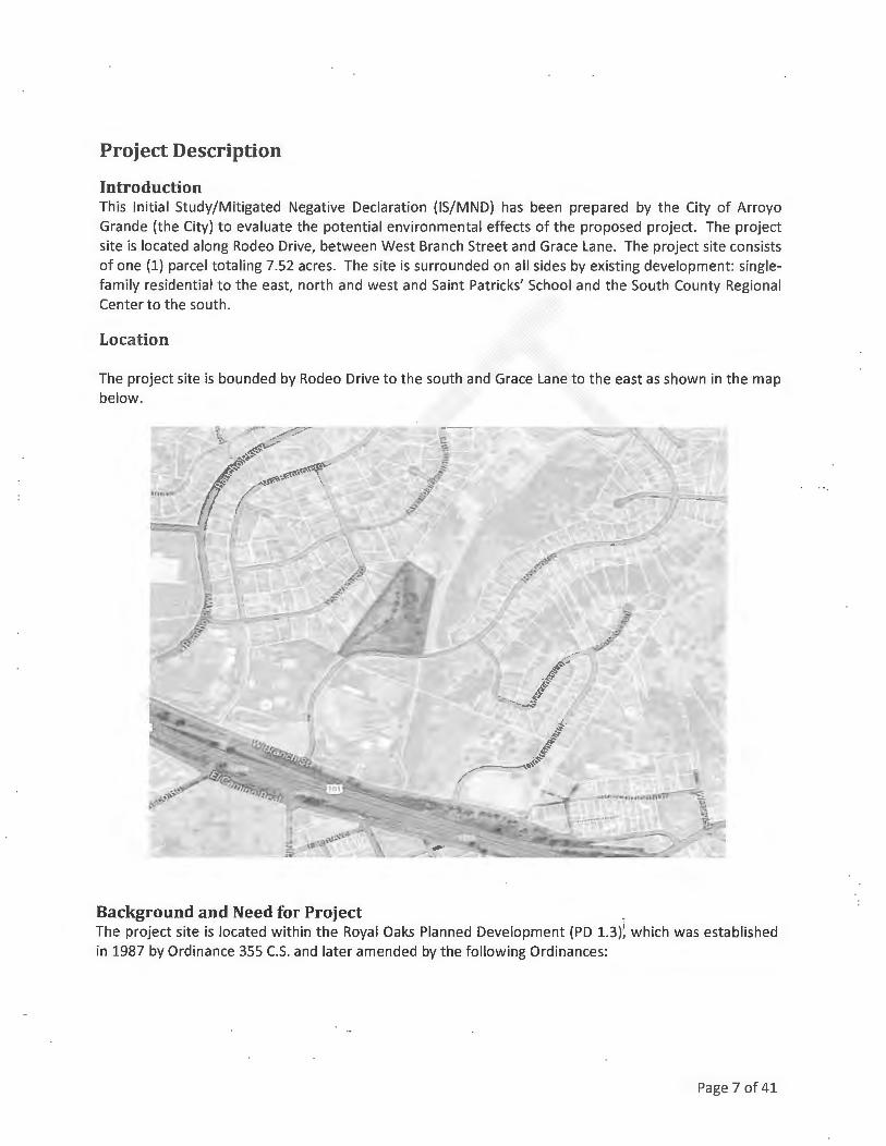
Project Description
Introduction This Initial Study/Mitigated Negative Declaration (IS/MND) has been prepared by the City of Arroyo Grande (the City) to evaluate the potential environmental effects of the proposed project. The project site is located along Rodeo Drive, between West Branch Street and Grace Lane. The project site consists of one (1) parcel totaling 7.52 acres. The site is surrounded on all sides by existing development: singlefamily residential to the east, north and west and Saint Patricks' School and the South County Regional Center to the south.
Location
The project site is bounded by Rodeo Drive to the south and Grace Lane to the east as shown in the map below.
Background and Need for Project _ The project site is located within the Royal Oaks Planned Development (PD 1.3)'. which was established in 1987 by Ordinance 355 C.S. and later amended by the following Ordinances:
Page 7 of 41

INITIAL STUDY MITIGATED NEGATIVE DECLARATION
DCA 17-001; VTIM 16-001 February 2017
Ordinance No. Title 356
358 384 406 418 430 449
553
Amending 355 C.S. Re: Lot A and Via La Barranca Drainage System in Royal Oaks Estates Amending Lot A, and Lots 34-40 Lot Lines in Royal Oaks Estates Sidewalk Construction in Royal Oaks Subdivision Amending Ordinance No. 355 C.S. Royal Oaks Estates to Modify Exhibit "A" Amending Ord. No. 355 C.S. Royal Oaks Estates Amending Ordinance 355 C.S. by Allowing a Church on Lot B, Royal Oaks Amending Ordinance No. 355 C.S. "Royal Oaks Estates" by Allowing a Church on Lot 184 and Approving and Adopting Specific Development Plan 91-05 Amending Ordinance No. 355 C.S. "Royal Oaks Estates" To Increase The Maximum Allowed Density Within The Planned Development, And Amending The Zoning Map To Designate The Subject Property As Residential Rural (RR) With A Planned Development Overlay; Development Code Amendment 02-001, Applied For By Don McHaney, For Property Located On Grace Lane (Lot 182 And Portion Of Lot B Of Tract 1390)
The subject property is identified as Lot 184. Lots "B", 182 and 184 were zoned specifically for "single family estate homes" allowing only one dwelling unit per lot. The 2001 General Plan changed the land use of these lots from PD 1.3 residential estate lots to Residential Single Family Low Density with a Planned Development overlay (RSF-LD-PD), allowing up to one dwelling unit per acre. The applicant is seeking to develop Lot 184 by amending PD 1.3 and securing a subdivision entitlement to ultimately develop the site with seven (7) single-family residences.
Project Description Development Code Amendment 17-001 The proposed Development Code Amendment (DCA) will amend PDl.3 to allow residential development at a density of one (1) dwelling unit per acre consistent with the 2001 Arroyo Grande General Plan.
Vesting Tentative Tract Map 16-001 The proposed Vesting Tentative Tract Map (VTIM) will subdivide Lot 184 of PD 1.3 into seven (7) residential lots at a density of one (1) dwelling unit per acre. Also proposed is an offer of dedication for future road improvement purposes.
Required Public Agency Approvals No other public agency approvals are required for the proposed project.
Related Projects The proposed project is related to the larger Royal Oaks Planned Development 1.3.
Page 8 of 41

Environmental Checklist
Project Information
Project Title:
Lead Agency Name & Add ress:
Contact Person & Telephone Number:
DCA 17-001 & VTIM 16-001
City of Arroyo Grande 300 East Brach Street Arroyo Grande, CA 93420
Ke lly Heffernan, AICP Associate Planner (805) 473-5420
Project Location: Rodeo Drive and Grace Lane, Arroyo Grande, California
Project Sponsor Names & Addresses : Kirby Gordon Gordon Properties 760 Mattie Road, Suite Al Pismo Beach, CA 93449
Jeffry Emrick Garing Taylor & Associates 141 South Elm Street Arroyo Grande, CA 93420
General Plan Designation: Residential Single Family Low Density with a Planned Development overlay (RSF-LD-PD)
Zoning: Planned Development 1.3 (PD 1.3)
Description of Project: Refe r to page 8
Surrounding Land Uses & Setting: The project site is surrounded by St. Patrick's school and low-medium density residential development within the Rancho Grande Planned Development (PD 1.2) to the west, low-medium density residential development in the Grace Lane subdivision to the north, open space and low-medium density residential development to the east, and vacant multi-family residential property owned by San Luis Obispo County to the south. The project site itself is undeveloped.
Approval Required from Other Public Agencies: None
Page 9 of 41

INITIAL STUDY MITIGATED NEGATIVE DECLARATION DCA 17-001; VTTM 16-001
Environmental Factors Potentially Affected
February 2017
The environmental factors checked below would be potentially affected by this project, involving at least one impact that is a "Potentially Significant Impact", as indicated by the checklist on the following pages:
~ Aesthetics ~Biological Resources ~ Greenhouse Gas Emissions D Land Use/Planning D Population/Housing D Transportation/Traffic
Determination
D Agricultural Resources ~Cultural Resources D Hazards & Hazardous Materials D Mineral Resources D Public Services D Utilities/Service Systems
On the basis of this initial evaluation:
~Air Quality D Geology/Soils ~ Hydrology/Water Quality
~Noise D Recreation D Mandatory Findings of Significance
D I find that the proposed project COULD NOT have a significant effect on the environment and a NEGATIVE DECLARATION will be prepared.
I find that, although the original scope of the proposed project COULD have had a significant effect on the environment, there WILL NOT be a significant effect because revisions/mitigations to the project have been made by or agreed to by the applicant. A MITIGATED NEGATIVE
DECLARATION will be prepared.
D I find that the proposed project MAY have a significant effect on the environment and an ENVIRONMENTAL IMPACT REPORT or its functional equivalent will be prepared.
D I find that the proposed project MAY have a "potentially significant impact" or "potentially significant unless mitigated impact" on the environment. However, at least one impact has been adequately analyzed in an earlier document, pursuant to applicable legal standards, and has been addressed by mitigation measures based on the earlier analysis, as described in the report's attachments. An ENVIRONMENTAL IMPACT REPORT is required, but it must analyze only the impacts not sufficiently addressed in previous documents.
D I find that, although the proposed project could have had a significant effect on the environment, because all potentially significant effects have been adequately analyzed in an earlier EIR or Negative Declaration, pursuant to applicable standards, and have been avoided or mitigated, pursuant to an earlier EIR, including revisions or mitigation measures that are imposed upon the proposed project, all impacts have been avoided or mitigated to a less-thansignificant level and no further action is required.
Kelly Heffernan, AICP Associate Planner
Date
Page 10 of 41

INITIAL STUDY MITIGATED NEGATIVE DECLARATION
DCA 17-001; VTIM 16-001
Evaluation of Environmental Impacts
February 2017
1. A brief explanation is required for all answers, except "No Impact", that are adequately supported by the information sources cited . A "No Impact" answer is adequately supported if the referenced information sources show that the impact does not apply to the project being evaluated (e.g., the project falls outside a fault rupture zone). A "No Impact" answer should be explained where it is based on general or project-specific factors (e.g., the project will not expose se.nsitive receptors to pollutants, based on a project-specific screening analysis).
2. All answers must consider the whole of the project-related effects, both direct and indirect, including off-site, cumulative, construction, and operational impacts.
3. Once the lead agency has determined that a particular physical impact may occur, the checklist answers must indicate whether that impact is potentially significant, less than significant with mitigation, or less than significant. "Potentially Significant Impact" is appropriate when there is sufficient evidence that a substantial or potentially substantial adverse change may occur in any of the physical conditions within the area affected by the project that cannot be mitigated below a level of significance. If there are one or more "Potentially Significant Impact" entries, an Environmental Impact Report (EIR) is required.
4. A "Mitigated Negative Declaration" (Negative Declaration: Less Than Significant with Mitigation Incorporated) applies where the incorporation of mitigation measures, prior to declaration of project approval, has reduced an effect from "Potentially Significant Impact" to a "Less Than Significant Impact with Mitigation." The lead agency must describe the mitigation measures and briefly explain how they reduce the effect to a less than significant level.
5. Earlier analyses may be used where, pursuant to the tiering, program EIR, or other CEQA process, an effect has been adequately analyzed in an earlier EIR (including a General Plan) or Negative Declaration [CCR, Guidelines for the Implementation of CEQA, § 15063(c)(3)(D)]. References to an earlier analysis should: a) Identify the earlier analysis and state where it is available for review. b) Indicate which effects from the environmental checklist were adequately analyzed in the
earlier document, pursuant to applicable legal standards, and whether these effects were adequately addressed by mitigation measures included in that analysis.
c) Describe the mitigation measures in this document that were incorporated or refined from the earlier document and indicate to what extent they address site-specific conditions for this project.
6. Lead agencies are encouraged to incorporate references to information sources for potential impacts into the checklist or appendix (e.g., general plans, zoning ordinances, biological assessments). Reference to a previously prepared or outside document should include an indication of the page or pages where the statement is substantiated.
7. A source list should be appended to this document. Sources used or individuals contacted should be listed in the source list and cited in the discussion.
8. Explanation(s) of each issue should identify: a) the criteria or threshold, if any, used to evaluate the significance of the impact addressed by
each question and b) the mitigation measures, if any, prescribed to reduce the impact below the level of
significa nee.
Page 11of41

Environmental Issues
I. Aesthetics
Environmental Setting The area of the project proposed for development has been previously graded and has lost its natural appearance to some degree. Several Coast Live oak trees exist on the eastern slope of the site where no grading has occurred. Other existing vegetation includes Sycamore and Eucalyptus trees, various shrubs and non-native grasses. Public improvements for the tract, including installation of utilities, drainage basins and the access road (Rodeo Court), will require the removal of several trees, altering the appearance of the site.
The vacant property is located on a knoll and is visible from US Highway 101 and residential development to the east. Development of the site with seven (7) residences will alter the view shed from these vantage points.
Would the project:
a) Have a substantial adverse affect on a scenic vista? b) Substantially damage scenic resources, including, but not limited to, trees, rock outcroppings, and historic buildings within a state scenic highway? c) Substantially degrade the existing visual character or quality of the site and its surroundings? d) Create a new source of substantial light or glare which would adversely affect day or nighttime views in the area?
Discussion a-b, d: No impact.
Potentially Significant
Impact
D
D
D
D
Less Than Significant
with Mitigation
D
D
D
Less Than Significant
Impact
D
D
D
D
No Impact
D
C: Subdivision and ultimate development of the site will change the character of the greater neighborhood area. Although the site was previously graded, it contains a variety of native and nonnative trees in an open space setting. Given that the property is visible from several vantage points, including US Highway 101, and because specific development standards are not applicable to this property, sensitive design of the future homes is critical. To lessen visual impacts, each home shall be reviewed by the City's Architectural Review Committee with special consideration given to the massing and exterior materials and colors. The homes shall be constructed to not obstruct views of existing surrounding residences, with subdued colors that harmonize with the surrounding environment. Less than significant with mitigation. j
MM 1-1: Prior to issuance of a building permit to construct a home on an individual lot within the subdivision, the Architectural Review Committee shall review the design of the home through the Architectural Review permit application process. Homes shall be similar in design to those within the adjacent Grace Lane and Rancho Grande subdivisions. Special attention shall be
Page 12 of 41

INITIAL STUDY MITIGATED NEGATIVE DECLARATION DCA 17-001; VTTM 16-001
February 2017
placed on the massing and exterior colors and materials of individual homes to lessen the visual impact from US Highway 101 and residential development to the east.
References: 2, 3, 14, 18
II. Agriculture and Forestry Resources
Environmental Setting The project site is not designated or zoned for agriculture use, has not been used for agricultural production and is not near to land zoned agriculture. The site does not contain prime soils according to the California Department of Conservation's Important Farmland Map of San Luis Obispo County.
Would the project:
a) Convert Prime Farmland, Unique Farmland, or Farmland of Statewide Importance (Farmland), as shown on the maps prepared pursuant to the Farmland Mapping and Monitoring Program of the California Resources Agency, to non-agricultural use? b) Conflict with existing zoning for agricultural use or a Williamson Act contract? c) Conflict with existing zoning for, or cause rezoning of, forest land (as defined in Public Resources Code section 12220)g)), timberland (as defined by Public Resources Code section 4526), or timberland zoned Timberland Production (as defined by Government Code section 51104(g))? d) Result in the loss of forest land or conversion of forest land to non-forest use? e) Involve other changes in the existing environment which, due to their location or nature, could result in conversion of Farmland to non-agricultural use?
Potentially
Significant Impact
D
D
D
D
D
Less Than Significant
with Mitigation
D
D
D
D
D
Less Than Significant
Impact
D
D
D
D
D
No Impact
*In determining whether impacts to agricultural resources are significant environmental effects, lead agencies may refer to the California Agricultural Land Evaluation and Site Assessment Model {1997), prepared by the California Department of Conservation as an optional model for use in assessing impacts on agricultural and farmland.
Discussion a-e: No impacts.
References: 1, 2, 3, 4, 9, 14
Page 13 of 41
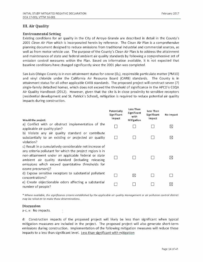
INITIAL STUDY MITIGATED NEGATIVE DECLARATION DCA 17-001; VTIM 16-001
III. Air Quality
Environmental Setting
February 2017
Existing conditions for air quality in the City of Arroyo Grande are described in detail in the County's 2001 Clean Air Plan which is incorporated herein by reference. The Clean Air Plan is a comprehensive planning document designed to reduce emissions from traditional industrial and commercial sources, as well as from motor vehicle use. The purpose of the County's Clean Air Plan is to address the attainment and maintenance of state and federal ambient air quality standards by following a co~prehensive set of emission control measures within the Plan. Based on information available, it is not expected that baseline conditions have changed significantly since the 2001 plan was completed.
San Luis Obispo County is in non-attainment status for ozone (03), respireable particulate matter (PMlO) and vinyl chloride under the California Air Resource Board (CARB) standards. The County is in attainment status for all other applicable CARB standards. The proposed project will construct seven (7) single-family detached homes, which does not exceed the threshold of significance in the APCD's CEQA Air Quality Handbook (2012). However, given that the site is in close proximity to sensitive receptors (residential development and St. Patrick's School), mitigation is required to reduce potential air quality impacts during construction.
Would the project:
a) Conflict with or obstruct implementation of the applicable air quality plan? b) Violate any air quality standard or contribute substantially to an existing or projected air quality violation? c) Result in a cumulatively considerable net increa.se of any criteria pollutant for which the project region is in non-attainment under an applicable federal or state ambient air quality standard (including releasing emissions which exceed quantitative thresholds for ozone precursors)? d) Expose sensitive receptors to substantial pollutant concentrations? e) Create objectionable odors affecting a substantial number of people?
Potentially
Significant Impact
D
D
D
D
D
Less Than Significant
with Mitigation
D
D
D
D
Less Than Significant
Impact
D
D
D
D
D
No Impact
D
* Where available, the significance criteria established by the applicable air quality management or air pollution control district may be relied on to make these determinations.
Discussion a-c, e: No impacts.
d: Construction impacts of the proposed project will likely be less than significant when typical mitigation measures are included in the project. The proposed project will also generate short-term emissions during construction. Implementation of the following mitigation measures will reduce these impacts to a less than significant level. Less than significant with mitigation
Page 14 of 41

INITIAL STUDY MITIGATED NEGATIVE DECLARATION
DCA 17-001; VTIM 16-001
February 2017
MM 111-1: On-road diesel vehicles shall comply with Section 2485 of Title 13 of the California Code of Regulations. This regulation limits idling from diesel-fueled commercial motor vehicles with gross vehicular weight ratings of more than 10,000 pounds and licensed for operation on highways. It applies to California and non-California based vehicles. In general the regulation specifies that drivers of said vehicles :
• Shall not idle the vehicle's primary di.esel engine for greater than 5 minutes at any location.
• Shall not operate a diesel-fueled auxiliary power system (APS) to power a heater, air conditioner, or any ancillary equipment on that vehicle during sleeping or resting in a sleeper berth for greater that 5 minutes at any location when within 1,000 feet of a restricted area.
MM 111-2: Off-road diesel equipment shall comply with the 5-minute idling restriction identified in Section 2449(d)(2) of the California Air Resources Board's In-Use Off-Road Diesel regulation.
MM 111-3: Signs must be posted in the designated queuing areas and job sites to remind drivers and operators of the State's 5 minute idling limit.
MM 111-4: The project applicant shall comply with these more restrictive requirements to minimize impacts to nearby sensitive receptors (adjacent residential and school development) :
• Staging at queuing areas shall not be located within 1,000 feet of sensitive receptors;
• Diesel idling within 1,000 feet of sensitive receptors shall not be permitted; • Use of alternative fueled equipment is recommended; and
• Signs that specify no idling areas must be posted and enforced at the site.
MM 111-5: The project shall implement the following mitigation measures to manage fugitive dust emissions such that they do not exceed the APCD's 20% opacity limit (APCD Rule 401) or prompt nuisance violations (APCD Rule 402):
• Reduce the amount of the disturbed area where possible; • Use of water trucks or sprinkler systems in sufficient quantities to prevent airborne dust
from leaving the site and from exceeding the APCD's limit of 20% opacity for greater than 3 minutes in any 60 minute period. Increased watering frequency would be required when wind speeds exceed 15 mph. Reclaimed (non-potable) water should be used whenever possible;
• All dirt stock pile areas should be sprayed daily and covered with tarps or other dust barriers as needed;
• Permanent dust control measures identified in the approved project revegetation and landscape plans shall be implemented as soon as possible, following completion of any soil disturbing activities;
• Exposed ground areas that are planned to be reworked at dates greater than one month after initial grading should be shown with a fast germinating, non-invasive, grass seed and watered until vegetation is established;
Page 15 of 41

INITIAL STUDY MITIGATED NEGATIVE DECLARATION
DCA 17-001; VTIM 16-001 February 2017
• All disturbed soil areas not subject to revegetation should be stabilized using approved chemical soil binders, jute netting, or other methods approved in advance by the APCD;
• All roadways, driveways, sidewalks, etc. to be paved should be completed as soon as possible. In addition, building pads should be laid as soon as possible after grading unless seeding or soil binders are used;
• Vehicle speed for all construction vehicles shall not exceed 15 mph on any unpaved surface at the construction site;
• All trucks hauling dirt, sand, soil, or other loose materials are to be covered or should maintain at least two feet of freeboard (minimum vertical distance between top of load and top of trailer) in accordance with eve Section 23.114;
• Install wheel washers where vehicles enter and exit unpaved roads onto streets, or wash off trucks and equipment leaving the site;
• Sweep streets at the end of each day if visible soil material is ca rried onto adjacent paved roads. Water sweepers shall be used with reclaimed water should be used where feasible . Roads shall be pre-wetted prior to sweeping when feasible;
• A listing of all required mitigation measures should be included on grading and building plans; and,
• The contractor or builder shall designate a person or persons to monitor the fugitive dust emissions and enhance the implementation of the measures as necessary to minimize dust complaints, reduce visible emissions below the APCD's limit of 20% opacity for greater than 3 minutes in any 60 minute period . Their duties shall include holidays and weekend periods when work may not be in progress. The name and telephone number of such persons shall be provided to the APCD Compliance Division prior to the start of any grading, earthwork or demolition.
MM 111-6: Prior to the start of the project, the applicant shall obtain all necessary permits for equipment to be used during construction by contacting the APCD Engineering Division at (805) 781-5912.
MM 111-7: Prior to any grading activities, the project sponsor shall ensure that a geologic evaluation is conducted to determine if naturally occurring asbestos (NOA) is present within the area that will be disturbed . If NOA is not present, an exemption request must be filed with the APCD. If NOA is found at the site, the applicant must comply with all requirements outlined in the Air Resource Board (ARB) Air Toxics Control Measure (ATCM) for Construction, Grading, Quarrying and Surface Mining Operations.
MM 111-8: Burning of vegetative material on the development site shall be prohibited .
MM 111-9: Should hydrocarbon-contaminated soil be encountered during construction activities, the APCD shall be notified within forty-eight (48) hours of such contaminated soil being discovered to determine if an APCD permit is required . In addition, the following measures shall be implemented immediately after contaminated soil is discovered:
• Covers on storage piles shall be maintained in place at all times in areas not actively involved in soil addition or removal.
Page 16 of 41

INITIAL STUDY MITIGATED NEGATIVE DECLARATION DCA 17-001; VTIM 16-001
February 2017
• Contaminated soil shall be covered with at least six (6) inches of packed, uncontaminated soil or other TPH - non-permeable barrier such as plastic tarp. No headspace shall be allowed where vapors could accumulate.
• Covered piles shall be designed in such a way as to eliminate erosion due to wind or water. No openings in the covers are permitted.
• During soil excavation, odors shall not be evident to such a degree as to cause a public nuisance.
• Clean soil must be segregated from contaminated soil.
References: 1, 4, 10, 11, 14
IV. Biological Resources
Environmental Setting The site is mostly devoid of flora and fauna apart from several native Coast Live oak trees, a couple of Sycamore trees, a eucalyptus tree, shrubs and invasive grasses/weeds. Existing development on three (3) sides of the project site precludes its use as a wildlife corridor.
Would the project:
a) Have a substantial adverse effect, either directly or through habitat modification, on any species identified as a sensitive, candidate, or special status species in local or regional plans, policies, or regulations, or by the California Department of Fish and Game or the U.S. Fish and Wildlife Service? b) Have a substantial adverse effect on any riparian habitat or other sensitive natural community identified in local or regional plans, policies, or regulations, or by the California Department of Fish and Game or the U.S. Fish and Wildlife Service? c) Have a substantial adverse effect on federally protected wetlands, as defined by §404 of the Clean Water Act (including, but not limited to, marsh, vernal pool, coastal, etc.) through direct removal, filling, hydrological interruption, or other means? d) Interfere substantially with the movement of any native resident or migratory fish or wildlife species or with established native resident or migratory wildlife corridors, or impede the use of native wildlife nursery sites? e) Conflict with any local policies or ordinances protecting biological resources, such as a tree preservation policy or ordinance?
Potentially Significant
Impact
D
D
D
D
D
Less Than Significant
with Mitigation
D
D
D
D
Less Than Significant
Impact
D
D
D
D
D
No Impact
D
Page 17 of 41

INITIAL STUDY MITIGATED NEGATIVE DECLARATION
DCA 17-001; VTTM 16-001
f) Conflict with the provisions of an adopted Habitat Conservation Plan, Natural Community Conservation Plan, or other approved local, regional, or state habitat conservation plan?
Discussion a-d, f : No impacts.
D
February 2017
D D
e: Project construction will primarily occur on previously disturbed areas. However, two (2) Sycamore trees and one (1) Eucalyptus tree will be removed to install public improvements. It is likely that oak tree removal will also occur when individual lots are developed. Coast Live oak trees are a protected species within the City of Arroyo Grande (Chapter 12.16 of the Arroyo Grande Municipal Code), and therefore grading activities near Coast Live oak trees and/or tree removal requires mitigation. Less than significant with mitigation.
MM IV-1: Protective fencing shall be installed at the dripline around each tree to remain. The fencing shall be installed prior to any site clearing, grading, or demolition activities, and shall remain in place until construction is complete, including landscaping. Weatherproof signs shall be permanently posted on the fences, stating the following:
Tree Protection Zone No personnel, equipment, materials, or vehicles are allowed
Do Not move or remove this fence
[Name of arborist or consultant] [Name and phone number of developer or general contractor]
MM IV-2: Removal of Coast Live oak trees of any size shall be replaced in kind at a 3:1 ratio on the project site. The replacement trees shall be 15-gallon in size and called out as "mitigation trees" on the final landscape and irrigation plan.
References: 3, 14, 15, 17
V. Cultural Resources
Environmental Setting The earliest inhabitants of Arroyo Grande Valley were the northern or Obispeno Chumash Indians. Given the long history of the Chumash occupying this region, many archaeological sites have been identified within the City limits. However, records show that no archeological sites have been recorded within one-half mile of the project site. The property has also been previously graded, making it less likely that
Page 18 of 41

INITIAL STUDY MITIGATED NEGATIVE DECLARATION
DCA 17-001; VTTM 16-001 February 2017
cultural resources are present on the site. Nevertheless, isolated archaeological materials could still be present given the extensive history of Chumash Indians inhabiting this area.
Would the project:
a) Cause a substantial adverse change in the significance of a historical resource as defined in §
15064.5? b) Cause a substantial adverse change in the significance of an archaeological resource pursuant to § 15064.5? c) Directly or indirectly destroy a unique paleontological resource or site or unique geologic feature? d) Disturb any human remains, including those interred outside of formal cemeteries?
Discussion a. No impact.
Potentially Significant
Impact
D
D
D
D
Less Than Less Than
Significant with
Significant No Impact
Mitigation Impact
D D
D D
D D
D D
b-d : As a precaution, if cultural resources are encountered during the construction process, development activities at the site shall cease until a qualified archaeologist has been employed to view and assess the discovery and prepare a mitigation plan. Implementation of the following mitigation measures will reduce these impacts to a less than significant level. Less than significant with mitigation.
MM V-1: If a potentially significant cultural resource is encountered during subsurface earthwork activities, all construction activities within a 100-foot radius of the find shall cease until a qualified archaeologist determines whether the uncovered resource requires further study. A standard inadvertent discovery clause shall be included in every grading and construction contract to inform contractors of this requirement. Any previously undiscovered resources found during construction shall be recorded on appropriate California Department of Parks and Recreation (DPR) forms and evaluated for significance in terms of California Environmental Quality Act criteria by a qualified archaeologist. Potentially significant cultural resources consist of, but are not limited to, stone, bone, glass, ceramic, wood, or shell artifacts; fossils; or features including hearths, structural remains, or historic dumpsites. If the resource is determined significant under CEQA, the qualified archaeologist shall prepare and implement a research design and archaeological data recovery plan that will capture those categories of data for which the site is significant. The archaeologist shall also perform appropriate technical analysis, prepare a comprehensive report, and file it with the appropriate Information Center and provide for the permanent cu ration of the recovered materials.
MM V-2: If human remalns are encountered during earth-disturbing activities, all work in the adjacent area shall stop immediately and the San Luis Obispo County Coroner's office shall be notified. If the remains are determined to be Native American in origin, the Native American Heritage Commission shall be notified and will identify the Most Likely Descendent, who will be consulted for recommendations for treatment of the discovered remains.
Page 19 of 41

INITIAL STUDY MITIGATED NEGATIVE DECLARATION
DCA 17-001; VTIM 16-001
References: 1, 3, 5
VI. Geology and Soils
Environmental Setting
February 2017
The project site is elevated, sloping up from both Rodeo Drive and Grace Lane to the north and east with an average elevation of approximately two hundred and twenty five (225} feet above mean sea level. The site is bordered by a significant slope (approximately 2:1) on the western property line and an approximate 2:1 descending fill slope on the remaining property lines. The extent of prior grading is unknown. The site has existed in its current configuration for more than ten (10) years.
Near surface soils generally consist of clayey sand to a depth of 4-5 feet In a very moist to wet state. Highly compacted course sand/gravel materials are present on the soil surface, likely a result of disturbance by past grading and compaction of native soil.
Would the project:
a) Expose people or structures to potential substantial adverse effects, including the risk of loss, injury, or death involving:
i) Rupture of a known earthquake fault, as delineated on the most recent Alquist-Priolo Earthquake Fault Zoning Map, issued by the State Geologist for the area, or based on other substantial evidence of a known fault? (Refer to Division of Mines and Geology Special Publication 42.) ii) Strong seismic ground shaking? iii) Seismic-related ground failure, including liquefaction? iv) Landslides?
b) Result in substantial soil erosion or the loss of topsoil? c) Be located on a geologic unit or soil that is unstable, or that would become unstable, as a result of the project and potentially result in on- or off-site landslide, lateral spreading, subsidence, liquefaction, or collapse? d) Be located on expansive soil, as defined in Table 18-1-B of the Uniform Building Code (1994), creating substantial risks to life or property? e) Have soils incapable of adequately supporting the use of septic tanks or alternative waste disposal systems, where sewers are not available for the disposal of waste water?
Potentially Significant
Impact
D
D
D
D
D
Less Than Significant
with Mitigation
D
D
D
D
D
Less Than Significant
Impact
D
D
D
D
No Impact
D
Pa ge 20 of 41

INITIAL STUDY MITIGATED NEGATIVE DECLARATION
DCA 17-001; VTIM 16-001
Discussion
February 2017
a: A geotechnical investigation of the project site was performed by GeoSolutions Inc. (2014) . This investigation concluded that the project site is suitable for the proposed project if the recommendations contained in the investigation are incorporated into the project plans and specifications. Less than significant.
b-e: No impacts.
References: 16
VII. Greenhouse Gas Emissions
Environmental Setting The project site is located adjacent to existing residential development as well as the South County Regional Center and Saint Patrick's School.
Would the project:
a) Generate greenhouse gas emissions, either directly or indirectly, that may have a significant effect on the environment? b) Conflict with an applicable plan, policy or regulation adopted for the purpose of reducing the emissions of greenhouse gases?
Discussion
Potentially Significant
Impact
D
D
Less Than Less Than
Significant with
Significant No Impact
Mitigation Impact
D D
D D
a: Greenhouse Gas (GHG) Emissions are said to result in an increase in the earth's average surface temperature. This is commonly referred to as global warming. The rise in global temperature is associated with long-term changes in precipitation, temperature, wind patterns, and other elements of the earth's climate system. This is also known as climate change. These changes are now thought to be broadly attributed to GHG emissions, particularly those emissions that result from the human production and use of fossil fuels.
The passage of AB32, the California Global Warming Solutions Act (2006), recognized the need to reduce GHG emissions and set the greenhouse gas emissions reduction goal for the State of California into law. The law required that by 2020, State emissions must be reduced to 1990 levels. This is to be accomplished by reducing greenhouse gas emissions from significant sources via regulation, market mechanisms, and other actions. Subsequent legislation (e.g., SB97-Greenhouse Gas Emissions bill) directed the California Air Resources Board (CARB) to develop statewide thresholds.
Pursuant to the requirements of SB 97, the California Natural Resources Agency adopted amendments to the CEQA Guidelines for the feasible mitigation of GHG emissions or the effects of GHG emissions in March 2010. These guidelines are used in evaluating the cumulative significance of GHG emissions from the proposed project. According to the adopted CEQA Guidelines, impacts related to GHG emissions from the proposed project would be significant if the project would:
• Generate greenhouse gas emissions, either directly or indirectly, that may have a significant impact on the environment; and/or
Page 21of41

INITIAL STUDY MITIGATED NEGATIVE DECLARATION
DCA 17-001; VTIM 16-001 February 2017
• Conflict with an applicable plan, policy or regulation adopted for t he purpose of reducing the emissions of greenhouse gases.
The San Luis Obispo Air Pollution Control District (APCD) has adopted recommended GHG significance thresholds. These thresholds are based on AB 32 GHG emission reduction goals, which take into consideration the emission reduction strategies outlined in the Air Resource Board's Scoping Plan. The GHG significance thresholds include one (1) qualitative threshold and two (2) quantitative thresholds options for evaluation of operational GHG emissions. The qualitative threshold option is based on a consistency analysis in comparison to a Qualified Greenhouse Gas Reduction Strategy, or equitably similar adopted policies, ordinances and programs. If a project complies with a Qualified Greenhouse Gas Reduction Strategy that is specifically applicable to the project, then the project would be considered less than significant. In accordance with APCD significance thresholds, the project would be considered to result in a significant impact if it does not comply with a Qualified Greenhouse Gas Reduction Strategy, in this case one included in the City's adopted Climate Action Plan. The City's Climate Action Plan was developed to be consistent with CEQA Guidelines Section 15183.S{b) to mitigate emissions and climate change impacts and will therefore serve as a Qualified GHG Reduction Strategy for the City.
Under CEQA, an individual project's GHG emissions will generally not result in direct significant impacts. This is because the climate change issue is global in nature. However, an individual project could be found to contribute to a potentially significant cumulative impact. APCD has established mitigation measures to reduce project-level GHG emissions, which are consistent with the City's Climate Action Plan. Implementation of the following mitigation measure will reduce this impact to a less than significant level. Less than significant with mitigation.
MM Vll-1: Prior to issuance of a building permit, all construction plans shall incorporate the following GHG-reducing measures where applicable:
• Incorporate outdoor electrical outlets to encourage the use of electric appliances and tools.
• No residential wood burning appliances. • Trusses for south-facing portions of roofs shall be designed to handle dead weight loads
of standard solar-heated water and photovoltaic panels. Roof design shall include sufficient south-facing roof surface, based on structures size and use, to accommodate adequate solar panels. For south facing roof pitches, the closest standard roof pitch to the ideal average solar exposure shall be used .
• Increase the building energy rating by 20% above Title 24 requirements. Measures used to reach the 20% rating cannot be double counted.
• Plant drought tolerant, native shade trees along southern exposures of buildings to reduce energy used to cool buildings in summer.
• Utilize green building materials (materials which are resource efficient, recycled, and sustainable) available locally if possible.
• Install high efficiency heating and cooling systems.
• Design homes to include roof overhangs that are sufficient to block the high summer sun, but not the lower winter sun, from penetrating south facing windows (passive solar design).
• Utilize high efficiency gas or solar water heaters.
Page 22 of 41
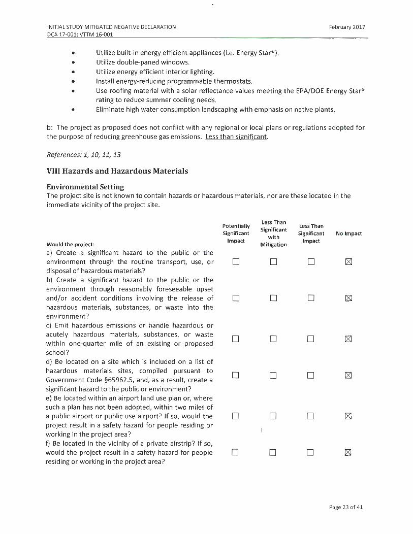
INITIAL STUDY MITIGATED NEGATIVE DECLARATION
DCA 17-001; VTIM 16-001
• Utilize built-in energy efficient appliances (i.e. Energy Star®). • Utilize double-paned windows.
• Utilize energy efficient interior lighting.
• Install energy-reducing programmable thermostats.
February 2017
• Use roofing material with a solar reflectance values meeting the EPA/DOE Energy Star® rating to reduce summer cooling needs.
• Eliminate high water consumption landscaping with emphasis on native plants.
b: The project as proposed does not conflict with any regional or local plans or regulations adopted for the purpose of reducing greenhouse gas emissions. Less than significant.
References: 1, 10, 11, 13
VIII Hazards and Hazardous Materials
Environmental Setting The project site is not known to contain hazards or hazardous materials, nor are these located in the immediate vicinity of the project site.
Would the project:
a) Create a significant hazard to the public or the environment through the routine transport, use, or disposal of hazardous materials? b) Create a significant hazard to the public or the environment through reasonably foreseeable upset and/or accident conditions involving the release of hazardous materials, substances, or waste into the environment? c) Emit hazardous emissions or handle hazardous or acutely hazardous materials, substances, or waste within one-quarter mile of an existing or proposed school? d) Be located on a site which is included on a list of hazardous materials sites, compiled pursuant to Government Code §65962.5, and, as a result, create a significant hazard to the public or environment? e) Be located within an airport land use plan or, where such a plan has not been adopted, within two miles of a public airport or public use airport? If so, would the project result in a safety hazard for people residing or working in the project area? f) Be located in the vicinity of a private airstrip? If so, would the project result in a safety hazard for people residing or working in the project area?
Potentially Significant
Impact
D
D
D
D
D
D
Less Than Significant
with Mitigation
D
D
D
D
D
D
Less Than Significant
Impact
D
D
D
D
D
D
No Impact
Page 23 of 41

INITIAL STUDY MITIGATED NEGATIVE DECLARATION DCA 17-001; VTIM 16-001
g) Impair implementation of or physically interfere with an adopted emergency response plan or emergency evacuation plan? h) Expose people or structures to a significant risk of loss, injury, or death from wildland fires, including areas where wildlands are adjacent to urbanized areas or where residences are intermixed with wild lands?
Discussion a-h: No impacts.
References: 4, 12
IX Hydrology and Water Quality
Environmental Setting
February 2017
D D D
D D D
The project site is vacant, was previously graded in areas, and is covered with a mix of weeds, native grasses, shrubs and scattered trees. Existing soils are varying shades of brown clayey sand.
The site is located in Stormwater Drainage Zone B of the Drainage Master Plan, which allows conveyance of storm water flows to creeks of natural drainage discourses. Stormwater currently flows to an existing detention basin constructed with the development of Tract No. 1390. Public improvements for the project, not including building pads for individual lots, will create approximately 20,049 square feet of new impervious area. Two (2) drainage basins are proposed to capture the runoff created by the access road and sidewalk. Each lot will be required to construct on site facilities to comply with post construction stormwater requirements. Low-impact development (LID) techniques are required to be implemented by the Central Coast Regional Water Quality Control Board (RWQCB) and will act to filter drainage water.
Would the project:
a) Violate any water quality standards or waste discharge requirements? b) Substantially deplete groundwater supplies or interfere substantially with groundwater recharge, such that there would be a net deficit in aquifer volume or a lowering of the local groundwater table level (e.g., the production rate of pre-existing nearby wells would drop to a level that would not support existing land uses or planned uses for which permits have been granted)? c) Substantially alter the existing drainage pattern of the site or area, including through alteration of the course of a stream or river, in a manner which would result in substantial on- or off-site erosion or siltation?
Potentially Significant
Impact
D
D
D
Less Than Significant
with Mitigation
D
D
D
less Than Significant
Impact
D
No Impact
D
D
Page 24 of 41

INITIAL STUDY MITIGATED NEGATIVE DECLARATION
DCA 17-001; VTIM 16-001
d) Substantially alter the existing drainage pattern of the site or area, including through alteration of the course of a stream or river, or substantially increase the rate or amount of surface runoff in a manner which would result in on- or off-site flooding? e) Create or contribute runoff water which would exceed the capacity of existing or planned stormwater drainage systems or provide substantial additional sources of polluted runoff? f) Substantially degrade water quality? g) Place housing within a 100-year flood hazard area, as mapped on a federal Flood Hazard Boundary or Flood Insurance Rate Map, or other flood hazard delineation map? h) Place structures that would impede or redirect flood flows within a 100-year flood hazard area? i) Expose people or structures to a significant risk of loss, injury, or death from flooding, including flooding resulting from the failure of a levee or dam? j) Result in inundation by seiche, tsunami, or mudflow?
Discussion
D
D
D
D
D
D
D
February 2017
D D
D D
D D
D D
D D
D D
D D
a: Development of the previously undeveloped property will result in an increase in the amount of impervious surface area. Post Construction Stormwater Requirements (PCSRs) have been developed for the project to provide the required retention volume through the construction of two (2) stormwater basins and the usage of Low LID standards for a 95th percentile design storm event. Less than significant impact.
b. The anticipated increase in water consumption by the project will result from seven (7) new single family residences. The property is zoned residential and water use projections and supplies for this property have already been included within the Water Master Plan. Less than significant impact.
c, d, e: No Impact.
f: The State Water Quality Control Board requires municipalities, via the National Pollutant Discharge Elimination System (NPDES) Permit, to minimize negative impacts on aquatic ecosystems and degradation of water quality to the maximum extent practicable. Permittees must implement Best Management Practices (BMPs) that reduce pollutants in storm water runoff to the technology-based standard of Maximum Extent Practicable (MEP) to protect water quality. The goals of post-construction BMPs are to prevent and control erosion and sedimentation, provide source control of potential pollutants, control and treat runoff, and protect wetlands and water quality resources. Postconstruction BMPs are required to achieve stormwater quality standards through site-planning measures.l Vegetative swales or other biofilters are recommended as the preferred choice for postconstruction BMPs for all projects with suitable landscape areas, because these measures are relatively economical and require limited maintenance. For projects where landscape based treatment is impracticable, or insufficient to meet required design criteria, other post-construction BMPs should be incorporated. All post-construction BMPs must be maintained to operate effectively. Implementation
Page 25 of 41

INITIAL STUDY MITIGATED NEGATIVE DECLARATION DCA 17-001; VTIM 16-001
February 2017
of the BMPs listed below will reduce the potential impacts to water quality to a less than significant level. Less than significant with mitigation.
MM IX-1: The following BMPs shall be incorporated into the project or the site/building design for each lot, as applicable:
• Roof Downspout System. Direct roof drains to pervious areas to allow infiltration prior to discharging to water, bodies or the municipal storm drain system.
• Run-off Control. Maintain post-development peak runoff rate and average volume of runoff at levels that are similar to pre-development levels.
• Labeling and Maintenance of Storm Drain Facilities. Label new storm drain inlets with "No Dumping - Drains to Ocean" to alert the public to the destination of stormwater and to prevent direct discharge of pollutants into the storm drain.
g, h, i, j: No impact.
References: 6, 7, 14
X. Land Use and Planning
Environmental Setting The project site is designated as Residential Single Family Low Density with a Planned Development overlay (RSF-LD-PD) in the City's Land Use Element and zoned Planned Development 1.3 Residential Estate (PDl.3-RE). The proposed type and scale of development of one (1) dwelling unit per acre will be consistent with both the RSF-LD-PD land use category and PDl.3-RE zoning district with the adoption of the Development Code Amendment.
Would the project:
a) Physically divide an established community? b) Conflict with the applicable land use plan, policy, or regulation of any agency with jurisdiction over the project (including, but not limited to, a general plan, specific plan, local coastal program, or zoning ordinance) adopted for the purpose of avoiding or mitigating an environmental effect? c) Conflict with any applicable habitat conservation plan or natural community conservation plan?
Discussion a, b, c: No impacts.
References: 1, 2, 4
Potentially Significant
Impact
D
D
D
Less Than Less Than
Significant with
Significant No Impact
Mitigation Impact
D D [8J
D D
D D
Page 26 of 41

INITIAL STUDY MITIGATED NEGATIVE DECLARATION DCA 17-001; VTIM 16-001
XI. Mineral Resources
Environmental Setting The project site does not contain any known mineral resources.
Would the.project:
a) Result in the loss of avai labil ity of a known minera l resource that is or would be of value to t he region and the resident s of t he st ate? b) Result in t he loss of ava ilability of a locally important mineral resource recovery site delineated on a local general pla n, specific plan, or other la nd use plan?
Discussion a-b: No impacts.
References: 5
XII. Noise
Environmental Setting
Potentially Significant
Impact
D
D
February 2017
Less Than Less Than
Significant with
Significant No Impact
Mitigation Impact
D D
D D
Noise exposure throughout the City is primarily caused by automobile traffic on surface streets and US Highway 101, with intermittent noise generated by agricultural operations and construction activities. The site is surrounded primarily by residential uses which are sensitive to noise outside of work day hours.
Would the project :
a) Generate or expose people to noise levels in excess of standards established in a local general plan or noise ordinance, or in other applicable local, state, or federal standards? b) Generate or expose people to excessive ground borne vibrations or ground borne noise levels? c) Create a substantial permanent increase in ambient noise levels in the vicinity of the project (above levels without the project)? d) Create a substantial temporary or periodic increase in ambient noise levels in the vicinity of the project, in excess of noise levels existing without the project?
Potentially Significant
Impact
D
D
D
D
Less Than Significant
with Mitigation
D
Less Than Significant
Impact
D
D
D
D
No Impact
D
D
D
Page 27 of 41

INITIAL STUDY MITIGATED NEGATIVE DECLARATION DCA 17-001; VTIM 16-001
e) Be located within an airport land use plan or, where such a plan has not been adopted, within two miles of a public airport or public use airport? If so, would the project expose people residing or working in the project area to excessive noise levels? f) Be in the vicinity of a private airstrip? If so, would the project expose people residing or working in the project area to excessive noise levels?
Discussion
D
D
February 2017
D D
D D
a, b, d: During construction of the proposed project, the use of construction vehicles and equipment has the potential to generate excessive levels of noise; however, this is only a temporary increase. All construction activities will comply with applicable City policies regarding noise. Less than significant impact with mitigation
MM Xll-1: Construction activities shall be restricted to between the hours of 8 a.m. and 5 p.m. Monday through Friday. No construction shall occur on Saturday or Sunday. Equipment maintenance and servicing shall be confined to the same hours. To the greatest extent possible, grading and construction activities should occur during the middle of the day to minimize the potential for disturbance of noise to neighboring sensitive uses.
MM Xll-2: All construction equipment utilizing internal combustion engines shall be required to have mufflers that are in good condition. Stationary noise sources shall be located at least 300 feet from occupied dwelling units unless noise reducing engine housing enclosures, or noise screens are provided by the contractor.
MM Xll-3: Equipment mobilization areas, water tanks, and equipment storage areas shall be placed in a central location as far from existing residences as feasible.
c, e, f: No impacts.
References: 1, 2, 3, 14
XIII. Population and Housing
Environmental Setting The project site is vacant. The proposed project is an infill development that will provide seven (7) new low density housing options for the community. No existing housing will be displaced.
Would the project:
a) Induce substantial population growth in an area, either directly (for example, by proposing new homes and businesses) or indirectly (for example, through extension of roads or other infrastructure)?
Potentially Significant
Impact
D
Less Than Significant
with Mitigation
D
Less Than Significant No Impact
Impact
D
Page 28 of 41

INITIAL STUDY MITIGATED NEGATIVE DECLARATION DCA 17-001; VTIM 16-001
b) Displace substantial numbers of existing housing, necessitating the construction of replacement housing elsewhere? c) Displace substantial numbers of people, necessitating the construction of replacement housing elsewhere?
Discussion
a, b, c: No impacts.
References: 1, 4, 14
XIV. Public Services
Environmental Setting
February 2017
D D D
D D D
The City of Arroyo Grande administers its own police department and parks and recreation facilities. Fire protection is provided by the Five Cities Fire Authority through a joint powers agreement (JPA). The Lucia Mar Unified School District (LMUSD) provides K-12 educational facilities. Public services to the project site are readily provided by the City of Arroyo Grande.
Would the project:
a) Result in significant environmental impacts from construction associated with the provision of new or physically altered governmental facilities, or the need for new or physically altered governmental facilities, to maintain acceptable service ratios, response times, or other performance objectives for any of the public services:
Fire protection? Police protection: Schools? Parks? Other public facilities?
Discussion
Potentially Significant
Impact
D
D D D D D
Less Than Significant
with Mitigation
D
D D D D D
Less Than Significant
Impact
D
D D ~ D D
No Impact
a: The project developer is require to pay Lucia Mar School District development fees. Less than significant impact.
References: 5, 14
XV. Recreation
Environmental Setting The Recreation Department oversees recreational activities throughout the City and manages the City's various parks and open spaces. The project will not affect any existing park or other recreational resource and is not expected to create additional demand for recreational facilities. Any potential
Page 29 of 41

INITIAL STUDY MITIGATED NEGATIVE DECLARATION DCA 17-001; VTIM 16-001
February 2017
impact will be mitigated by the City's standard condition requiring payment of park development and impact fees for the improvement or development of neighborhood community parks.
Would the project:
a) Increase the use of existing neighborhood and regional parks or other recreational facilities, such that substantial physical deterioration of the facility would occur or be accelerated? b) Include recreational facilities or require the construction or expansion of recreational facilities that might have an adverse physical effect on the environment?
Discussion
a, b: No impact
References: 5, 14
XVI. Transportation/Traffic
Environmental Setting
Potentially Significant
Impact
D
D
Less Than Less Than
Significant with
Significant No Impact
Mitigation Impact
. D D
D D
The project site is located at the corner of Rodeo Drive and Grace Lane, approximately 1000 feet from West Branch Street. The project site is located in an established residential neighborhood, with public facilities and St. Patrick's School to the south. An offer of dedication is proposed for future road improvements at the intersection of Rodeo Drive and Grace Lane for the purpose of traffic calming. The number of PM peak hour trips generated by the project (approximately 1) is less than the City's threshold of 18 PM peak hour trips. A traffic study is therefore not required.
Would the project:
a) Cause a substantial increase in traffic, in relation to existing traffic and the capacity of the street system (i.e., a substantial increase in either the number of vehicle trips, the volume to capacity ratio on roads, or congestion at intersections)? b) Exceed, individually or cumulatively, the level of service standards established by the county congestion management agency for designated roads or highways? i c) Cause a change in air traffic patterns, including either an increase in traffic levels or a change in location, that results in substantial safety risks?
Potentially Significant
Impact
D
D
D
Less Than
Significant with
Mitigation
D
D
D
Less Than Significant
Impact
D
D
D
No Impact
Page 30 of 41

INITIAL STUDY MITIGATED NEGATIVE DECLARATION DCA 17-001; VTIM 16-001
d) Contain a design feature (e.g., sharp curves or a dangerous intersection) or incompatible uses (e.g., farm equipment) that would substantially increase hazards? e) Result in inadequate emergency access? f) Result in inadequate parking capacity? g) Conflict with adopted policies, plans, or programs supporting alternative transportation {e_.g., bus turnouts, bicycle racks)?
Discussion a-f: No impact
References: 1, 14, 19
XVII. Utilities and Service Systems
Environmental Setting
D
D D
D
D
D D
D
D
D D
D
February 2017
The project site is located within the incorporated City Limits of Arroyo Grande. Utilities will be served by both the City and other regional entities.
Would the project:
a) Exceed wastewater treatment restrictions or standards of the applicable Regional Water Quality Control Board? b) Require or result in the construction of new water or wastewater treatment facilities or expansion of existing facilities? Would the construction of these facilities cause significant environmental effects? c) Require or result in the construction of new storm water drainage facilities or expansion of existing facilities? d) Have sufficient water supplies available to serve the project from existing entitlements and resources or are new or expanded entitlements needed? e) Result in a determination, by the wastewater treatment provider that serves or may serve the project, that it has adequate capacity to service the project's anticipated demand, in addition to the provider's existing commitments? f) Be served by a landfill with sufficient permitted capaeity to accommodate the project's solid waste disposal needs? g) Comply with federal, state, and local statutes and regulations as they relate to solid waste?
Potentially Significant
Impact
D
D
D
D
D
D
D
D
Less Than Significant
with Mitigation
D
D
D
D
D
D
D
D
Less Than Significant
Impact
D
D
D
D
D
D
No Impact
D
D
Page 31 of 41

INITIAL STUDY MITIGATED NEGATIVE DECLARATION DCA 17-001; VTIM 16-001
February 2017
a: Wastewater generated by the proposed project will be treated by the South County Sanitation District, which has adequate capacity to accommodate the increase. Less than significant impact
b, c: No impact d: The 2015 Urban Water Management Plan provides water demand factors per single family household in 2015. In 2015, 5,907 single family connections utilized 1,517 acre feet of water per year (afy), for an average of 3.89,afy per single family household. An additional seven (7) single family homes constructed on new lots would add 27.23 afy per year to the current water demand. This amount of demand is covered by existing resources in the projected build-out population of 20,000 residents. Additionally, all new development in the City is required to either implement a water neutralization program or pay a water neutralization fee to offset increased water demand generated by the development. Therefore, there are sufficient water supplies available to serve the project, even in light of current drought conditions. Less than significant impact
e-g: No impact
References: 1, 3, 6, 7, 8, 14
Mandatory Findings of Significance
Would the project:
a) Substantially degrade the quality of the environment, substantially reduce the habitat of a fish or wildlife species; cause a fish or wildlife population to drop below self-sustaining levels; threaten to eliminate a plant or animal community; substantially reduce the number or restrict the range of an endangered, rare or threatened species; or eliminate examples of the major periods of California history or prehistory? b) Have the potential to achieve short-term environmental goals to the disadvantage of long-term environmental goals? c) Have possible environmental effects that are individually limited but cumulatively considerable? "Cumulatively considerable" means that the incremental effects of an individual project are significant when viewed in connection with the effects of past projects, the effects of other current projects, and the effects of possible future projects. d) Cause substantial adverse effects on human beings, either directly or indirectly?
Potentially Significant
Impact
D
D
D
D
Less Than Significant
with Mitigation
D
D
D
D
Less Than Significant
Impact
D
No Impact
D
D
D
Page 32 of 41

INITIAL STUDY M ITIGATED NEGATIVE DECLARATION
DCA 17-001; VTIM 16-001
Discussion
February 2017
a: Although undeveloped, the project site does not contain any significant flora or fauna, and because it is surrounded by urban development, the site does not have any potential to serve as a wildlife corridor. Isolated prehistoric materials may be present on the project site; however, the sit e does not serve as an example of a major period of California history or prehistory.
b: There are no short-term environmental goals, either in the project description or the identified mitigation measures, that will be achieved to the disadvantage of long-term environmental goals.
c: The proposed project is consistent with the City's General Plan as it relates to future growth, both in general terms and specifically as it relates to the project site. While the proposed project will cumulatively increase traffic and demand for public services and utilities, with implementation of the proposed mitigation measures, it will not result in any cumulatively considerable environmental impacts.
d: With implementation of the proposed mitigation measures, the proposed project will not cause substantial adverse effects on human beings, either directly or indirectly.
Page 33 of 41
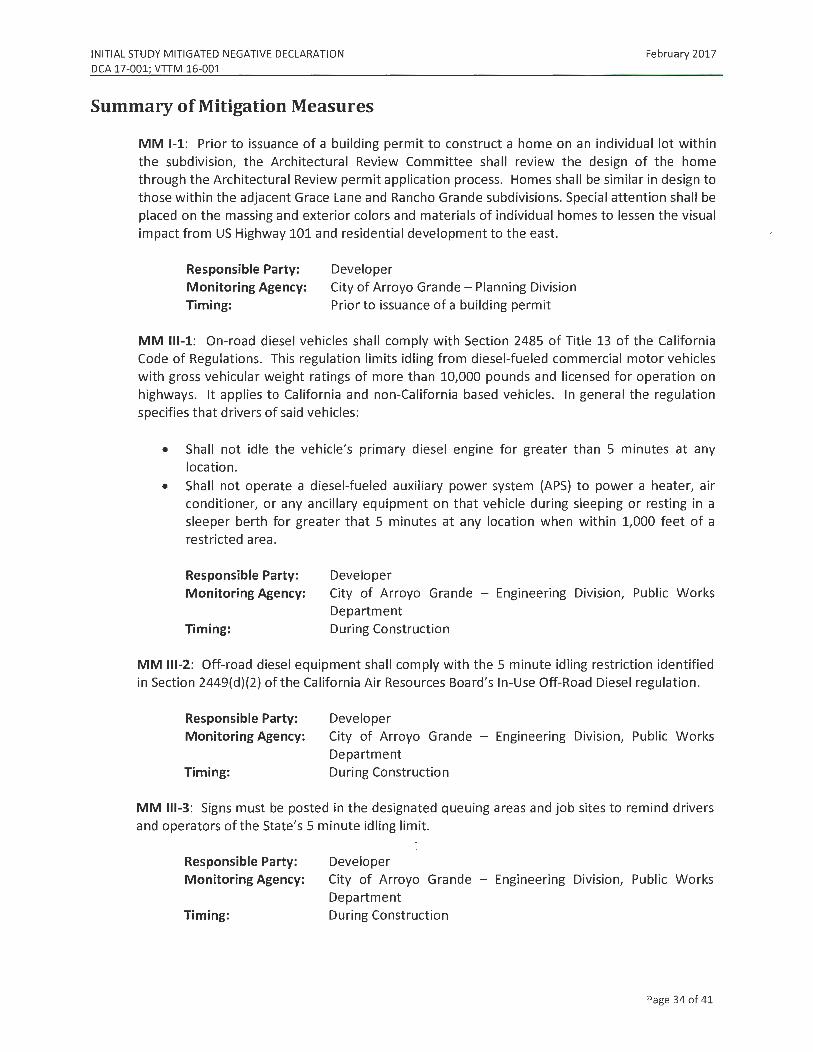
INITIAL STUDY MITIGATED NEGATIVE DECLARATION
DCA 17-001; VTIM 16-001
February 2017
Summary of Mitigation Measures
MM 1-1: Prior to issuance of a building permit to construct a home on an individual lot within the subdivision, the Architectural Review Committee shall review the design of the home through the Architectural Review permit application process. Homes shall be similar in design to those within the adjacent Grace Lane and Rancho Grande subdivisions. Special attention shall be placed on the massing and exterior colors and materials of individual homes to lessen the visual impact from US Highway 101 and residential development to the east.
Responsible Party: Monitoring Agency: Timing:
Developer City of Arroyo Grande - Planning Division Prior to issuance of a building permit
MM 111-1: On-road diesel vehicles shall comply with Section 2485 of Title 13 of the California Code of Regulations. This regulation limits idling from diesel-fueled commercial motor vehicles with gross vehicular weight ratings of more than 10,000 pounds and licensed for operation on highways. It applies to California and non-California based vehicles. In general the regulation specifies that drivers of said vehicles:
• Shall not idle the vehicle's primary diesel engine for greater than 5 minutes at any location.
• Shall not operate a diesel-fueled auxiliary power system (APS) to power a heater, air conditioner, or any ancillary equipment on that vehicle during sleeping or resting in a sleeper berth for greater that 5 minutes at any location when within 1,000 feet of a restricted area.
Responsible Party: Monitoring Agency:
Timing:
Developer City of Arroyo Grande - Engineering Division, Public Works Department During Construction
MM 111-2: Off-road diesel equipment shall comply with the 5 minute idling restriction identified in Section 2449(d)(2) of the California Air Resources Board's In-Use Off-Road Diesel regulation.
Responsible Party: Monitoring Agency:
Timing:
Developer City of Arroyo Grande - Engineering Division, Public Works Department During Construction
MM 111-3: Signs must be posted in the designated queuing areas and job sites to remind drivers and operators of the State's 5 minute idling limit.
Responsible Party: Monitoring Agency:
Timing:
j Developer City of Arroyo Grande - Engineering Division, Public Works Department During Construction
Page 34 of 41

INITIAL STUDY MITIGATED NEGATIVE DECLARATION
DCA 17-001; VTIM 16-001 February 2017
MM 111-4: The project applicant shall comply with these more restrictive requirements to minimize impacts to nearby sensitive receptors (adjacent residential development):
• Staging a queuing areas shall not be located within 1,000 feet of sensitive receptors; • Diesel idling within 1,000 feet of sensitive receptors shall not be permitted; • Use of alternative fueled equipment is recommended; and
• Signs that specify no idling areas must be posted and enforced at the site.
Responsible Party: Developer Monitoring Agency: City of Arroyo Grande - Engineering Division, Public Works
Department Timing: During Construction
MM 111-5: The project shall implement the following mitigation measures to manage fugitive dust emissions such that they do not exceed the APCD's 20% opacity limit (APCD Rule 401) or prompt nuisance violations (APCD Rule 402):
• Reduce the amount of the disturbed area where possible; • Use of water trucks or sprinkler systems in sufficient quantities to prevent airborne dust
from leaving the site and from exceeding the APCD's limit of 20% opacity for greater than 3 minutes in any 60 minute period. Increased watering frequency would be required when wind speeds exceed 15 mph. Reclaimed (non-potable) water should be used whenever possible;
• All dirt stock pile areas should be sprayed daily and covered with tarps or other dust barriers as needed;
• Permanent dust control measures identified in the approved project revegetation and landscape plans shall be implemented as soon as possible, following completion of any soil disturbing activities;
• Exposed ground areas that are planned to be reworked at dates greater than one month after initial grading should be shown with a fast germinating, non-invasive, grass seed and watered until vegetation is established;
• All disturbed soil areas not subject to revegetation should be stabilized using approved chemical soil binders, jute netting, or other methods approved in advance by the APCD;
• All roadways, driveways, sidewalks, etc. to be paved should be completed as soon as possible. In addition, building pads should be laid as soon as possible after grading unless seeding or soil binders are used;
• Vehicle speed for all construction vehicles shall not exceed 15 mph on any unpaved surface at the construction site;
• All trucks hauling dirt, sand, soil, or other loose materials are to be covered or should maintain at least two feet of freeboard (minimum vertical distance between top of load and top of trailer) in accordance with eve Section 23'114;
• Install wheel washers where vehicles enter and exit unpaved roads onto streets, or wash off trucks and equipment leaving the site;
• Sweep streets at the end of each day if visible soil material is carried onto adjacent paved roads. Water sweepers shall be used with reclaimed water should be used where feasible. Roads shall be pre-wetted prior to sweeping when feasible;
Page 35 of 41

INITIAL STUDY MITIGATED NEGATIVE DECLARATION
DCA 17-001; VTIM 16-001
February 2017
• A listing of all required mitigation measures should be included on grading and building plans; and,
• The contractor or builder shall designate a person or persons to monitor the fugitive dust emissions and enhance the implementation of the measures as necessary to minimize dust complaints, reduce visible emissions below the APCD's limit of 20% opacity for greater than 3 minutes in any 60 minute period. Their duties shall include holidays and weekend periods when work may not be in progress. The name and telephone number of such persons shall be provided to the APCD Compliance Division prior to the start of any grading, earthwork or demolition.
Responsible Party: Monitoring Agency:
Timing:
Developer City of Arroyo Grande - Engineering Division, Public Works Department During Construction
MM 111-6: Prior to the start of the project, the applicant shall obtain all necessary permits for equipment to be used during construction by contacting the APCD Engineering Division at (805) 781-5912.
Responsible Party:
Monitoring Agency:
Timing:
Developer City of Arroyo Grande - Engineering Division, Public Works Department Prior to start of work
MM 111-7: Prior to any grading activities, the project sponsor shall ensure that a geologic evaluation is conducted to determine if naturally occurring asbestos (NOA) is present within the area that will be disturbed. If NOA is not present, an exemption request must be filed with the APCD. If NOA is found at the site, the applicant must comply with all requirements outlined in the Air Resource Board (ARB) Air Toxics Control Measure (ATCM) for Construction, Grading, Quarrying and Surface Mining Operations.
Responsible Party: Monitoring Agency:
Timing:
Developer City of Arroyo Grande - Engineering Division, Public Works Department, APCD Prior to issuance of grading permit
MM 111-8: Burning of vegetative material on the development site shall be prohibited .
Responsible Party: Monitoring Agency:
Timing:
Developer City of Arroyo Grande - Engineering Division, Public Works Department During Construction
MM 111-9: Should hydrocarbon-contaminated soil be encountered during construction activities, the APCD shall be notified within forty-eight (48) hours of such contaminated soil being discovered to determine if an APCD permit is required. In addition, the following measures shall be implemented immediately after contaminated soil is discovered:
Page 36 of 41

INITIAL STUDY MITIGATED NEGATIVE DECLARATION
DCA 17-001; VTTM 16-001
February 2017
• Covers on storage piles shall be maintained in place at all times in areas not actively involved in soil addition or removal.
• Contaminated soil shall be covered with at least six (6) inches of packed, uncontaminated soil or other TPH - non-permeable barrier such as plastic tarp. No headspace shall be allowed where vapors could accumulate.
• Covered piles shall be designed in such a way as to eliminate erosion due to wind or wate r. No openings in the covers are permitted.
• During-soil excavation, odors shall not be evident to such a degree as to cause a public nuisance.
• Clean soil must be segregated from contaminated soil.
Responsible Party: Monitoring Agency:
Timing:
MM IV-1:
Developer City of Arroyo Grande - Engineering Division, Public Works Department During Construction
Protective fencing shall be installed at the dripline around each tree to remain. The fencing shall be installed prior to any site clearing, grading, or demolition activities, and shall remain in place until construction is complete, including landscaping. Weatherproof signs shall be permanently posted on the fences, stating the following:
Tree Protection Zone No personnel, equipment, materials, or vehicles are
allowed Do Not move or remove this fence
[Name of arborist or consultant] [Name and phone number of developer or general contractor]
Responsible Party: Developer Monitoring Agency: City of Arroyo Grande - Engineering Division, Public Works
Department Timing: During Construction
MM IV-2: Removal of Coast Live oak trees of any size shall be replaced in kind at a 3:1 ratio on the project site . The replacement trees shall be 15-gallon in size and called out as "mitigation trees" on the final landscape and irrigation plan.
Responsible Party: Monitoring Agency: Timing:
Developer City of Arroyo Grande - Planning Division Prior to issuance of building permit (approval of landscape and irrigation plan) and prior to final (planting of trees)
Page 37 of 41

INITIAL STUDY MITIGATED NEGATIVE DECLARATION
DCA 17-001; VTIM 16-001 February 2017
MM V-1: If a potentially significant cultural resource is encountered during subsurface earthwork activities, all construction activities within a 100-foot radius of the find shall cease until a qualified archaeologist determines whether the uncovered resource requires further study. A standard inadvertent discovery clause shall be included in every grading and construction contract to inform contractors of this requirement. Any previously undiscovered resources found during construction shall be recorded on appropriate California Department of Parks and Recreation (DPR) forms and evaluated for significance in terms of California Environmental Quality Act criteria by a qualified archaeologist. Potentially significant cultural resources consist of, but are not limited to, stone, bone, glass, ceramic, wood, or shell artifacts; fossils; or features including hearths, structural remains, or historic dumpsites. If the resource is determined significant under CEQA, the qualified archaeologist shall prepare and implement a research design and archaeological data recovery plan that will capture those categories of data for which the site is significant. The archaeologist shall also perform appropriate technical analysis, prepare a comprehensive report, and file it with the appropriate Information Center and provide for the permanent cu ration of the recovered materials.
Responsible Party: Monitoring Agency:
Timing:
Developer City of Arroyo Grande - Engineering Division, Public Works Department During construction
MM V-2: If human remains are encountered during earth-disturbing activities, all work in the adjacent area shall stop immediately and the San Luis Obispo County Coroner's office shall be notified. If the remains are determined to be Native American in origin, the Native American Heritage Commission shall be notified and will identify the Most Likely Descendent, who will be consulted for recommendations for treatment of the discovered remains.
Responsible Party: Monitoring Agency:
Timing:
Developer City of Arroyo Grande - Engineering Division, Public Works Department During construction
MM Vll-1: Prior to issuance of a building permit, all construction plans shall incorporate the following GHG-reducing measures where applicable:
• Incorporate outdoor electrical outlets to encourage the use of electric appliances and tools.
• No residential wood burning appliances. • Trusses for south-facing portions of roofs shall be designed to handle dead weight loads
of standard solar-heated water and photovoltaic panels. Roof design shall include sufficient south-facing roof surface, based on structures size and use, to accommodate adequate solar panels. For south facing roof pitches, the closest standard roof pitch to the ideal average solar exposure shall be used. ·
• Increase the building energy rating by 20% above Title 24 requirements. Measures used to reach the 20% rating cannot be double counted.
• Plant drought tolerant, native shade trees along southern exposures of buildings to reduce energy used to cool buildings in summer.
Page 38 of 41

INITIAL STUDY MITIGATED NEGATIVE DECLARATION
DCA 17-001; VTIM 16-001
February 2017
• Utilize green building materials (materials which are resource efficient, recycled, and sustainable) available locally if possible.
• Install high efficiency heating and cooling systems.
• Design homes to include roof overhangs that are sufficient to block the high summer sun, but not the lower winter sun, from penetrating south facing windows (passive solar design).
• Utilize high efficiency gas or solar water heaters. • Utilize built-in energy efficient appliances (i.e . Energy Star®).
• Utilize double-paned windows. • Utilize energy efficient interior lighting.
• Install energy-reducing programmable thermostats. • Use roofing material with a solar reflectance values meeting the EPA/DOE Energy Star®
rating to reduce summer cooling needs.
• Eliminate high water consumption landscaping with emphasis on native plants.
Responsible Party: Monitoring Agency:
Timing:
Developer City of Arroyo Grande - Planning, Building and Engineering Divisions Prior to issuance of a Grading Permit or Building Permit
MM IX-1: The following BMPs shall be incorporated into the project:
• Roof Downspout System. Direct roof drains to pervious areas to allow infiltration prior to discharging to water bodies or the municipal storm drain system.
• Run-off Control. Maintain post-development peak runoff rate and average volume of runoff at levels that are similar to pre-development levels.
• Labeling and Maintenance of Storm Drain Facilities. Label new storm drain inlets with "No Dumping - Drains to Ocean" to alert the public to the destination of stormwater and to prevent direct discharge of pollutants into the storm drain.
Responsible Party: Monitoring Agency:
Timing:
Developer City of Arroyo Grande - Planning, Building, and Engineering Divisions Prior to issuance of a Building Permit
MM Xll-1: Construction activities shall be restricted to between the hours of 8 a.m. and 5 p.m. Monday through Friday. No construction shall occur on Saturday or Sunday. Equipment maintenance and servicing shall be confined to the same hours. To the greatest extent possible, grading and construction activities should occur during the middle of the day to minimize the potential for disturbance of neighboring noise sensitive uses.
Responsible Party: Monitoring Agency:
Timing:
Developer City of Arroyo Grande - Planning, Building, and Engineering Divisions During construction
Page 39 of 41

INITIAL STUDY MITIGATED NEGATIVE DECLARATION
DCA 17-001; VTIM 16-001 February 2017
MM Xll-2: All construction equipment utilizing internal combustion engines shall be required to have mufflers that are in good condition. Stationary noise sources shall be located at least 300 feet from occupied dwelling units unless noise reducing engine housing enclosures or noise screens are provided by the contractor.
Responsible Party: Monitoring Agency:
Timing:
Developer City of Arroyo Grande - Planning, Building, an.d Engineering Divisions During construction
MM Xll-3: Equipment mobilization areas, water tanks, and equipment storage areas shall be placed in a central location as far from existing residences as feasible .
Responsible Party: Monitoring Agency:
Timing:
Developer City of Arroyo Grande - Planning, Building, and Engineering Divisions During construction
Page 40 of 41
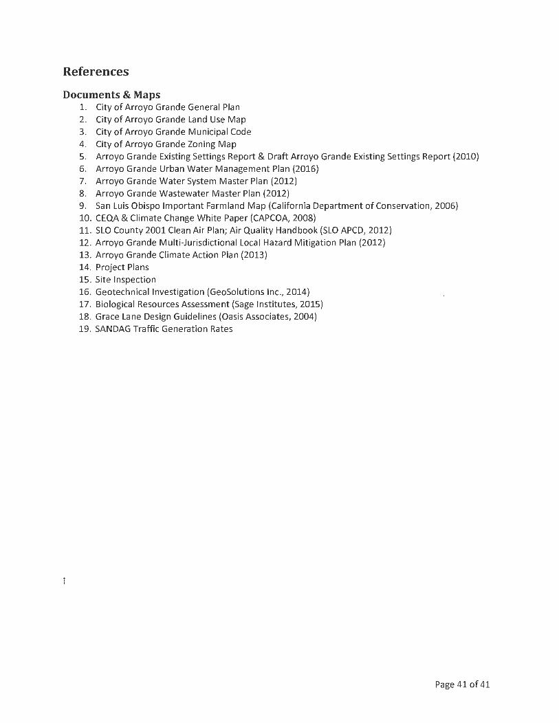
References
Documents & Maps 1. City of Arroyo Grande General Plan 2. City of Arroyo Grande Land Use Map 3. City of Arroyo Grande Municipal Code 4. City of Arroyo Grande Zoning Map 5. Arroyo Grande Existing Settings Report & Draft Arroyo Grande Existing Settings Report (2010) 6. Arroyo Grande Urban Water Management Plan (2016) 7. Arroyo Grande Water System Master Plan (2012) 8. Arroyo Grande Wastewater Master Plan (2012) 9. San Luis Obispo Important Farmland Map (California Department of Conservation, 2006) 10. CEQA & Climate Change White Paper (CAPCOA, 2008) 11. SLO County 2001 Clean Air Plan; Air Quality Handbook (SLO APCD, 2012) 12. Arroyo Grande Multi-Jurisdictional Local Hazard Mitigation Plan (2012) 13. Arroyo Grande Climate Action Plan (2013) 14. Project Plans 15. Site Inspection 16. Geotechnical Investigation (GeoSolutions Inc., 2014) 17. Biological Resources Assessment (Sage Institutes, 2015) 18. Grace Lane Design Guidelines (Oasis Associates, 2004) 19. SANDAG Traffic Generation Rates
Page 41of41

heal © slo HEALTHY EATING ACTIVE LIVING
San L.uis Obispo Cow1ty
COALITION PARTNERS:
Bike SLO County
Boys and Girls Club - South County
Cal Poly State University
Art and Department
Center for Sustainability
Food Science & Nutrition Department
Kinesiology Department
STRIDE
CenCal Health
City of San Luis Obispo Parks and Recreation
Community Action Partnership of SLO
Community Foundation of San Luis Obispo
County
Dairy Council of California
Diringer & Associates
First 5 San Luis Obispo County
Food Bank Coalition of SLO County
French Hospital Medical Center
Lucia Mar Unified School District
One Cool Earth
Rideshare - Safe Routes to School
San Luis Sports Therapy
SLO Council of Governments
SLO County Departments:
Board of Supervisors
Health Commission
Planning and Building
Public Health
SLO County Office of Education
The Community Foundation SLO County
UC Cooperative Extension
YMCA of SLO County
ATTACHMENT 7
March 7, 2017
TO: Kelly Heffernan, Associate Planner, City of Arroyo Grande
FROM: HEAL-SLO - Healthy Communities Work Group
RE: Vesting Tentative Tract Map No. 16-001(Tract3079) & Development Code Amendment 17-001
The Healthy Communities Work Group has reviewed the project noted above and has the following comments:
1. We support the location of this project as an infill development. The project location has close proximity to many services, including shopping, transit services, Class II and III bike lanes, a public library, schools, and parks. Residents in this location would be able to walk or ride a bicycle to all of these services.
2. To increase access to affordable rental housing in the community, especially housing in a walk-able location, we would recommend incorporating accessory dwelling units, either attached or detached, which can serve as either a rental apartment or an office space, as an option for buyers. Providing an optional accessory dwelling unit as part of initial land use approvals can result in efficiencies of construction cost, mortgage financing, timing, and site design.
In addition, please see the attached map, which illustrates the project's proximity to transit, bicycle lanes, schools, grocery stores, and farmer's markets.
Thank you for the opportunity to review this project.
cc: San Luis Obispo County Health Commission

heal ® slo HEALTHY EA ING ACTIVE LIVING
.:;an Luis Obispo Col.int~·
ArcGIS y Proxim ity to Se rvices Modify Map .:., Sign In
{ lJ DEta1ls ] lHi Basem ap
0 0
Contents
~ Map Notes
O Tran s1tSt ops20 14 F1xedRo t1t e
~ Trans1tRoutes20 H Local
O Trans1t S'¥cAr ea LocalSvcHalfMtle
O Trans1tStops20 14 F1xedRout e30M1n
D Trans1tRoutes20H 30MinSvc
O Tra ns1t5vcArea 30fl.·1in5 1iCHalfMllE!
~ Trans1t5tops2014 Regional
~ Trans1tRoutes20 14 Region al
O Trans1tSvcArea Reg1onatSvcHalfM1le
D B1keways2016 Class lPat hs
O 81kewavs Class l SvcArea l MlleWalk
~ 81kewa vs20 16 Class ll Coastal
D Bikeways20 16 Class II Inland
E1ri.com .._Ip Ter.,.,a of Us• onY•t"I Contact E..1m R•pcut Abu1e
Legend: Blue Marker: Blue lines and dots: Red lines: Yellow Stars: Black dots: Black bullseyes: Orange pinpoint: Pink lines:
•• @
•.... -,, ,, ,,.,, I 7
1 111•!· r
I · tC..•
Project location Transit routes and stops Class II & Ill bicycle lanes
' Share ~ Pnnt Measure Rodeo Or. Jnd Grace Ln, arrovo orande, ca
Bu tt1llU o i Land M011nag• m • nt, Esr1, HEi'.E Garmm IUCR EMErlT P. l nt• rma p, U ,, '
Schools (elementary, middle, and high schools) Grocery stores Farmer's markets Trail head City boundaries
x o.. J
·" ·'' ..
• I ~
'"1,,,
HEAL-SLO is the SLO County obesity prevention coalit ion and its mission is to increase healthy eating and regular physical activity among County
residents through policy, behavioral and environmental changes. In carrying out that mission, a subcommittee called the Healthy Commun ities Work Group provides responses to Planning staff from a healthy community's perspective on proposed fond development projects, ordinance and general plan
amendments, and special projects.

ATTACHMENT 8