Embed Size (px)
Citation preview

James Cook’s 1763-4 survey of Newfoundland’s Northern Peninsula reassessed
Andrew DavidLa découverte en janvier 1986 de deux cartes manuscrites par James Cook dans la collection royale dans le château de Windsor, nous permet d'examiner à nouveau ses levés hydrographiques de la péninsule nord de Terre-Neuve en 1763-4. Ces levés se justifiaient en assistant à la définition des droits de pêche exercés par la Grande-Bretagne et la France en vertu du Traité de Paris, signé le 10 février 1763, qui a mis fin à la guerre de Sept Ans, et les cartes nouvellement découvertes peuvent offrir de nouveaux aperçus dans cette issue diplomatique importante. Cet article offre une description préliminaire des cartes et une analyse de leur importance éventuelle.
The discovery in January 19861 of two manuscript charts by James Cook in the Royal Collection, in Windsor Castle, enables us to examine afresh his survey of Newfoundland’s Northern Peninsula in 1763-4 and in particular the fishery rights exercised by both Britain and France under the terms of the Treaty of Paris, signed on 10 February 1763, which ended the Seven Years War. One of the charts in the Royal Collection is of the whole of Newfoundland2 and is very similar to another chart of Newfoundland by Cook, now held in the Admiralty Library, the Royal Naval Museum, Portsmouth.3 The Admiralty Library chart is dated 1763 and appears to have been drawn a few months before Cook sailed for Newfoundland with Captain Graves to begin his survey. From legends on this chart it is clear that its purpose was to illustrate the stretch of coast from Cape Bonavista on the east coast to Point Riche on the west coast, where the French were allowed to retain their fishing rights on the so-called French Shore under the terms of the Treaty and where the English regularly fished prior to the treaty being ratified.4 The similar chart in the Royal Collection was probably drawn by Cook in the winter of 1764/5 since it incorporates both his 1763 and 1764 surveys. The second chart
1 For details see Andrew David, “Further light on James Cook’s Survey of Newfoundland,” The International Hydrographic Review Vol. 1, No. 2 (New Series) (December 2000), 6-12.
2 The Royal Collection, 710058.b.3 The Admiralty Library, Royal Naval Museum, Portsmouth,, Vv 2, Vol. 1, folio 21. Illustrated
in A.M. Lysaght, Joseph Banks in Newfoundland & Labrador, 1766 (London, 1971), following page 56.
4 The French considered their rights to the Treaty Shore were exclusive, which the British did not accept.
The Northern Mariner/le marin du nord, XIX No. 4, (October 2009), 393-403

The Northern Mariner/Le marin du nord
in the Royal Collection5 covers the whole of Cook’s 1764 survey on a scale of 1:72,960, but this chart is not unique since two other almost identical versions of it also exist. The
5 The Royal Collection, 710058.a.
394
Illustration 1: A Sketch of the Island of Newfoundland: Done from the latest observations by James Cook, 1763. The Admiralty Library, Royal Naval Museum, Portsmouth, Atlas Vv2, Vol. 1, item 21. Reproduced by the permission of the Admiralty Librarian.
James Cook’s 1763-4 survey of Newfoundland’s Northern Peninsula reassessed
more significant of these is in the United Kingdom Hydrographic Office,6 since it contains a number of additional features, including a panel of detailed sailing directions, which occupy a large area at the bottom of the chart, which are not present on the corresponding chart in the Royal Collection. The Taunton chart is also squared in pencil, presumably to enable a cartographer to transfer detail to the engraved chart. The other version of this chart is in the British Library.7
Cook’s involvement in the survey of Newfoundland began in 1762. In the spring of that year, as the Seven Years War was drawing to a close, a small French squadron successfully evaded the British fleet blockading Brest and, after crossing the Atlantic, had little difficulty in capturing St John’s, which was defended by just sixty-three British troops. The French then proceeded to destroy fishing installations in St John’s and the vicinity. British reaction was swift. A squadron under the command of Commodore Lord Alexander Colville in HMS Northumberland was dispatched from Halifax, resulting in the speedy recapture of St John’s. The French squadron, however, managed to escape in a fog and returned safely to Brest.8 Cook, who was Master of the Northumberland, took the opportunity to carry out a number of surveys of which his survey of Carbonear Harbour and Harbour Grace9 was especially praised by Commodore Colville in a letter to John Clevland, first secretary to the Admiralty. In it he stated that Cook had been particularly careful in sounding out these two harbours and had discovered that ships of any size could lie in them in complete safety.10
When Captain Thomas Graves, governor of Newfoundland, was made aware that the French were being allowed to retain their fishing rights on the French Shore, it soon became clear to him that a detailed hydrographic survey of the island would be needed to help him enforce these rights. Graves had been present at the recapture of St John’s and had been impressed by Cook’s surveying abilities. As a result he specifically asked for Cook to be appointed to carry out the necessary survey. In their reply their Lordships informed Graves on 19 April 1763 that they had
thought fit to appoint Mr James Cook, a person well skilled in making Surveys...to go to Newfoundland in His Majesty’s Ship under your command in order to be employed in making surveys of the Coasts and Harbours of that Island, and in making Drafts and Charts thereof for which [he] will be allowed ten Shillings a day...You are hereby directed to receive [him] on board...and to employ [him] during your stay at Newfoundland as you shall see fit on the Service above mentioned.11
Presumably at Cook’s request, Graves asked the Admiralty to issue his surveyor
6 United Kingdom Hydrographic Office, Taunton (UKHO), c54/7.7 British Library, Add MS 31,360, f. 11.8 For an account of this affair see Andrew David, “James Cook’s 1762 Survey of St John’s
Harbour and Adjacent Parts of Newfoundland,” Terrae Incognitae Vol. 30 (1998), 63-71.9 Admiralty Library, MSS 20, book 3.10 Colville to Clevland, 25 October 1762, The National Archives (formerly the Public Record
Office)(TNA), Adm 1/482.11 TNA, Adm 2/90, pp. 124-5.
395

The Northern Mariner/Le marin du nord
with “A Theodolite and drawing instruments”12 and it is known that Cook also “took with him a very good apparatus of instruments,” including “a brass telescopic quadrant made by Mr John Bird,”13 a leading London instrument maker.
On 3 May Graves was further instructed that “[a]t the end of your voyage you are to send us exact and faithful Charts of the Coasts, and Drafts of the Harbours, noticing the Depth of Water, perpendicular rise of the Tides, Conveniences for Fishing, and whatever else may occur worthy of our knowledge...”14 These instructions applied not only to Cook, but also to the captains of a number of vessels under Graves’s command, who indeed carried out a number of surveys.
Cook arrived in Newfoundland with Graves in the Antelope on 15 May 1763. His first task was to survey the islands of St Pierre and Miquelon in the Tweed, Captain Charles Douglas, before the islands were handed over to the French under the terms of the Treaty of Paris. On completion of this survey Cook returned to St John’s where he joined a Massachusetts-built 68-ton schooner, which Graves had purchased for him to carry out his surveys. Formerly the Sally, she was renamed the Grenville by Graves, presumably in honour of George Grenville, the first lord of the treasury. Cook then sailed for the northern tip of the island where, in the next three months he surveyed York Harbour in Labrador, now called Chateau Bay, and Croque, Quirpon and Noddy Harbours at the northern tip of the island. Few details of Cook’s work during this brief season are known. His journal, if he kept one, has not survived and, since he was not in command of the Grenville, which was manned by seamen recruited in St John’s and was therefore not a ship of the Royal Navy, no log has survived either. Until recently the only copy of Cook’s survey of Croque Harbour was an unfinished ink and pencil plan in the Mitchell Library in Sydney in Australia.15 In 1997, however, I was fortunate to come across a a completed manuscript copy of this survey inset on a chart of the eastern side of the Northern Peninsula by Captain John Ruthven in HMS Terpsichore,16 who had been instructed to carry out such a survey in Graves’s instructions.
At the end of 1763 Cook returned to London with Graves in the Antelope, leaving the Grenville in St John’s, where John Tucker and Jonathan Babcock, two Newfoundland fishermen, had been engaged to look after her.17 This enabled Cook to draw his charts in the comfort of his own home in Mile End in the east end of London. He was also employed during the winter doing some historical research for the new governor, Captain Hugh Palliser, who was well known to Cook as he had served under him in 1755 in the
12 National Maritime Museum, Adm/B/148.13 Philosophical Transactions, LVII (1767), 215.14 TNA, Adm 2/90, pp. 186-7.15 Mitchell Library, State Library of New South Wales, PDX 11, f. I (b).16 Admiralty Library, Vv2, Vol. 1, folio 22. The Admiralty had instructed John Ruthven to
cruise between Cape Race and Quirpon and to “make the best chart you are able”; TNA, Adm 2/90, pp. 92-5, dated 5 April 1763. Captain Charles Douglas in the Tweed had been given similar instructions to cruise between Cape Ray and Cape Race; TNA, Adm 2/90, pp. 86-92.
17 TNA, Adm 2/90, pp. 173-4.
396

James Cook’s 1763-4 survey of Newfoundland’s Northern Peninsula reassessed
Eagle. The purpose of the research was to rebut the claim of the French Ambassador in London that Cape Ray, the south-western tip of the island, and not Point Riche, was the intended southern limit of French fishing operations on the west coast.18
The delay in having to cross the Atlantic and refit the Grenville meant that it was not until 14 July that Cook, now in command of the Grenville, could recommence his survey, which can now be described in greater detail with pertinent quotations from his log.19 Cook began his survey in Sacred Bay at the northern tip of the island, where he “Measured a Base Line and fix’d Flaggs on the Different Islands, &ca,”20 the standard way to survey such a bay. The remarkable fact about this statement is that I have not been able to find anywhere in his three Pacific Ocean journals any mention of his measuring a base or erecting flags, although he clearly must have done so for his harbour surveys. It
18 The claim that Cape Ray and Pointe Riche were the same place was the extreme French position. The more usual claim was that Pointe Riche was not where the British placed it ― near Port au Choix –– but just north of Bay of Islands. The French were anxious to extend their fishing area on the west coast, having lost control of the area on the east coast between Bonavista and Cape St John.
19 TNA, Adm 52/1263.20 Ibid, f. 111.
397
Illustration 2: A Chart of the Coast, Bays and Harbours in Newfoundland between the White Cape and Boat Harbour. Survey’d by...James Cook (detail showing graduation for latitude in vicinity of Sacred Bay). UK Hydrographic Office, c54/4. Reproduced by permission of the UK Hydrographic Office (www.ukho.gov.uk)

The Northern Mariner/Le marin du nord
took just six days for Cook to complete his survey of Sacred Bay. After obtaining soundings to seaward of the bay, Cook anchored two days later in Pistolet Bay, whose survey he completed on 31 July.
Cook now began to extend his survey to the south-west, first landing on 2 August on Cape Norman, the western entrance point of Pistolet Bay, where he measured the Sun’s meridian altitude, finding the cape to be in Latitude 51° 39′ North.21 This cape was one of six places where Cook took such observations during his 1764 season, each observation spot being indicated on his chart by a dot surrounded by a small circle. It is not clear what instrument he used to obtain his latitude. It could have been the astronomical quadrant by Bird, referred to above, but I think it was much more likely that on most occasions he used a sextant on a stand with an artificial horizon. The latitude obtained by these observations were indicated by arrows intersecting two graduations for latitude on his chart, with the arrows pointing towards the respective observation spots. The southernmost latitude of 51° 35′ 22″ on the chart was obtained later by Cook in Noddy Harbour. At this juncture I must point out that at no time during his Newfoundland survey was Cook able to carry out observations to establish his longitude. The method of obtaining longitude by lunar distances, first used by Cook in his First Pacific Voyage, was still in its infancy and it was not until his Second Pacific Voyage that chronometers were first used for survey purposes. However, he was aware of the problem of longitude and on 5 August 1766, having now his own telescope, he observed an eclipse of the Sun on Burgeo Islands off the south coast of the Newfoundland. The longitude of these islands was subsequently calculated in England by an amateur astronomer, Dr John Bevis,22 and later used by Cook in his printed sailing directions. Thus Cook’s manuscript charts and their engraved derivatives are not graduated for longitude.
On 2 August Cook landed to continue his survey on shore while the Grenville stood about 3 miles offshore, obtaining soundings every mile. The schooner’s log gives no indication of what survey operations Cook was carrying out but another of his manuscript surveys, on a larger scale, in the United Kingdom Hydrographic Office23 shows that he was carrying out a rudimentary form of triangulation, indicated by a series of dotted lines on the chart. He would also have been walking along the coastline to fix its position and possibly other topographical features by means of a plane table.
Then on 6 August disaster struck. A large powder horn blew up in Cook’s hand, which, as recorded in the log, “shatter’d it in a terrible manner.”24 The site of the disaster is almost certainly depicted by the name Unfortunate Cove on his larger scale chart, which was duly included on Cook’s engraved chart and which has survived to this day. As there was no surgeon on board the Grenville, the schooner made for Noddy Harbour, where a French fishing vessel, with a surgeon, lay at anchor. Cook’s wound was successfully treated, the Grenville remaining in Noddy Harbour until 25 August while
21 Ibid, f. 112.22 Bevis’s results were published in 1767 in the Philosophical Transactions LVII, 215-6.23 UKHO, c54/3.24 TNA, Adm 52/1263, f. 113.
398

James Cook’s 1763-4 survey of Newfoundland’s Northern Peninsula reassessed
Cook recovered. The time was not wasted, however, since on 8 August William Parker, the assistant surveyor, was sent to survey Griguet Bay and the coast south-west of Quirpon. By 23 August Cook had recovered sufficiently to land “a little above Noddy Island” and observe for latitude, recording it in his log as 51° 34′ 59″.25
Two days later the Grenville got under way and on 29 August, after rounding Cape Bauld, Cook landed once again, presumably in Unfortunate Cove, to continue the survey to the south-west along Straight Coast, towards Green Island, while the Grenville continued to sound at a convenient distance offshore. On 1 September two French snows were sighted standing to the east and the following day Cook made, as he wrote in his log, “the private signal to a ship in the Offing which we took to be the Solebay, but his signal was not answered.”26 The Solebay was one of five frigates under Palliser, with instructions to cruise between specific points on the Newfoundland coast. The Solebay was to cruise in the Strait of Belle Isle between Quirpon to Cape Ferolle, the Tweed between Cape Ferolle and Cape Ray, the Pearl between Cape Ray and Cape Race, the
25 Ibid, f. 113.26 Ibid, f. 115.
399
Illustration 3: A Chart of the Sea Coast of Newfoundland between Open Bay and Green Island. Survey’d by...James Cook (detail showing Unfortunate Cove and part of Cook’s triangulation). UK Hydrographic Office, c54/3. Reproduced by permission of the UK Hydrographic Office (www.ukho.gov.uk)

The Northern Mariner/Le marin du nord
Lark between Cape Race and Quirpon and the Spy to be with fishing vessels on the Grand Banks.27
On 6 September the Grenville’s mainsail and jib were split in a strong gale forcing Cook to anchor between Green Island and the mainland to enable him to bend on new sails. After remaining at anchor overnight, Cook got under way again the following morning, sending the schooner’s small boat inshore to sound a cove, which he took to be Anse Savage, today’s Savage Bay, while the Grenvilles ounded offshore. It was about this time that Cook sighted on the opposite coast a feature near Blanc Sablon, which he described in his published sailing directions as “a very remarkable mountain, forming at the Top three round Hills called our Ladies Bubbies.”28 Cook drew a sketch of this feature on his chart in the Royal Collection, but I have been unable to establish the origin of this name, but I cannot imagine that it was given by Cook in honour of Mrs Cook, who he had recently married. The feature was duly engraved on the published version of Cook’s survey, but the name, however, has not survived on official charts and sailing directions, being now described in Admiralty Sailing Directions as “three round-backed mountains over 305 m high” and, being in Quebec province, named Collines de Brador with the English language version, Bradore Hills, being given in brackets.29
If Cook was not responsible for the name Our Ladies Bubbies, he surely named a feature, about 9 miles south-west of Green Island, which he described in his published sailing directions covering his 1764 survey as “half a Mile from the Land, lies Grenville-Ledge, whereupon is 6 Feet Water,”30 although this feature is not mentioned in his log. On 16 September, having surveyed St Barbe Bay the previous day, Cook anchored in a small cove in St Genevieve Bay, where he remained for a week sheltering from a series of gales, which were accompanied at times with much snow, although this did not deter Cook from continuing his survey. On 23 September he got under way once again and spent the day sounding about half a miles offshore, anchoring the following day in Old Ferolle Harbour, where he took the opportunity to heel the Grenville first to port to scrub the starboard side and then to starboard to do the same to the port side. Two days later he got under way and “anchor’d in De Grat Ferrol off one of the stages in 2¾ fm water and moor’d with both Bowers,”31 where he remained until he completed the survey not only of Old Ferolle Harbour and St Margaret Bay, but also extending it as far as Ferolle Point. Off this point a minor disaster occurred when “the small Boat got ashore on one of the Ledges which Bilged and filld, [but] with the assistance of the Cutter the people were saved.”32
27 TNA, Adm 2/91, pp. 521-35, dated 30 April 1764 to Palliser in HMS Guernsey. The instructions quoted both the Treaty of Paris, signed on 10 February 1763, and the Treaty of Utrecht, signed in 1713, which had established French rights along the so-called French shore.
28 James Cook, Directions for Navigating on Part of the North East Side of Newfoundland, and in the Streights of Bell-Isle (London, 1769), 11.
29 St Lawrence Pilot, 13th ed. (Taunton, 1989), 42.30 Cook, Directions, 8.31 TNA, Adm 52/1263, f. 117.32 Ibid.
400
James Cook’s 1763-4 survey of Newfoundland’s Northern Peninsula reassessed
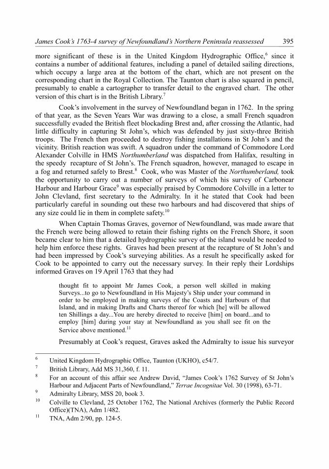
Running aground is a hazard all surveyors fear when surveying uncharted waters. Cook established his final observation spot of his 1764 season on Ferolle Point, where as depicted on another of his larger scale manuscript charts,33 three of his triangulation bearings can be seen radiating from the point. Also on this chart, in the south-west corner of St Margaret’s Bay, you can see the name Sole Bay. In this case Cook’s reason for this name is quite clear as nearby is an anchor symbol and the legend “Solebay’s watering place.” Clearly this is where the frigate Solebay wooded and watered. Cook remained in Old Ferolle Harbour until 5 October, when he got under way to return to St John’s.
Cook next crossed the Atlantic in the Grenville, enabling him to draw the fair copies of his charts once again in his own home. Since there was no Hydrographic Office at the time to publish them, Cook did so himself, first through Thomas Jeffreys, as mentioned earlier, and later through Mount and Page.
While Palliser’s instructions to Cook for his 1764 survey do not appear to have survived, one of them must have been to report on the positions of various fishing stages, which Cook did by depicting them on his surveys. Four of them can be seen on his large scale chart, depicting New Ferolle Harbour. Stages coloured red had a beach for drying 33 UKHO, 342.
401
Illustration 4: A Chart of the Sea Coast, Bays and Harbours, in Newfoundland between Green Point and Pointe Ferolle. Surveyed by... James Cook (left hand portion of chart). UK Hydrographic Office, 342. Reproduced by permission of the UK Hydrographic Office (www.ukho.gov.uk)
The Northern Mariner/Le marin du nord
fish on, those coloured green had flakes for drying fish on and those coloured yellow were places where Cook thought stages might be built.
However, Cook’s 1763 survey of Noddy Harbour does not depict any stages, but it does contains some pertinent remarks regarding fishing:
Little Quirpoon is a very snug place for mooring the Ships that come to cure their fish in this Harbour...These Harbours are very convenient for the Cod fishery as likewise is degrat cove which hath the preference, there is room in it for two ships and is generally taken up by the first that arrives. Notwithstanding the great plenty of Fish about these Harbours they are not frequented by the English, from an apprehension they are under of being visited by the Indians from the Coasts of Labradore.34
In his published sailing directions, Cook makes a number of references to fishing. Griguet Bay for instance “contains several good Harbours for Fishing of all kinds, wherein are many fishing conveniences.”35 Little Quirpon is “a small safe snug Harbour,
34 “A Plan of the Harbours of Quirpoon and Noddy...,” UKHO, c54/6. The “Indians” were in fact Inuit.
35 Cook, Directions, 4.
402
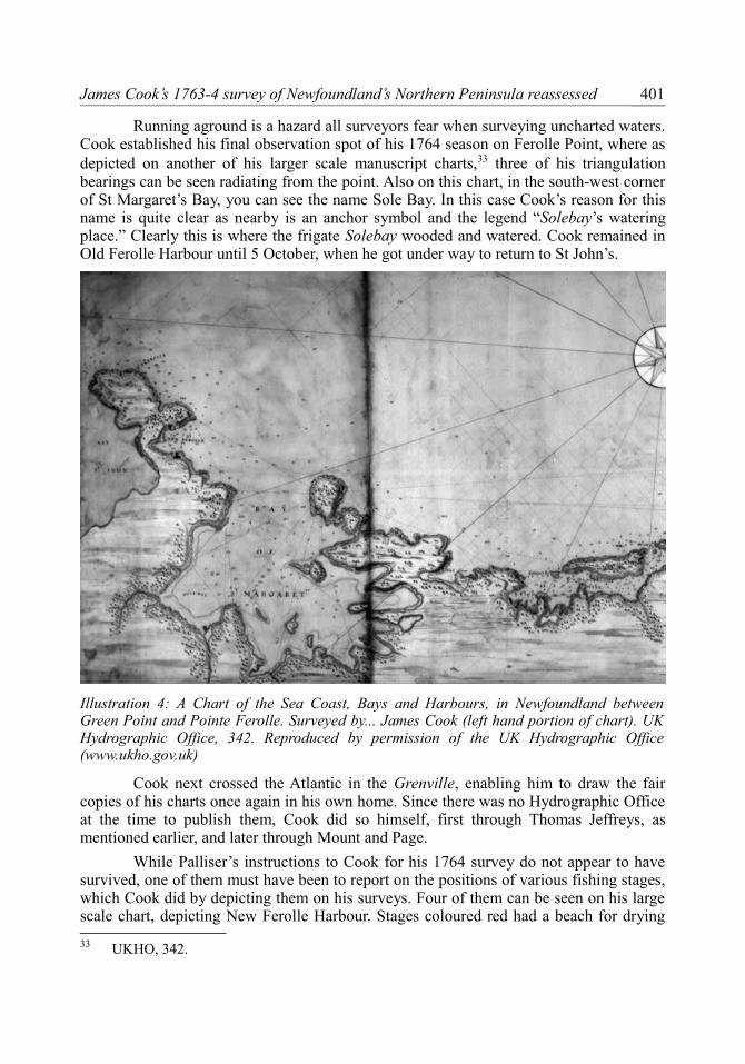
Illustration 5: A Chart of the Coasts, Bays and Harbours in Newfoundland between Griguet and Pt Ferolle. Survey’d by...James Cook (detail showing title and coast to the east of Green Island). UK Hydrographic Office, c54/7. Reproduced by permission of the UK Hydrographic Office (www.ukho.gov.uk).

James Cook’s 1763-4 survey of Newfoundland’s Northern Peninsula reassessed
where Fishing Ships Moor Head and Stern,”36 while he describes the harbour of Old Ferolle as “a very good and safe harbour” with “convenient Places for many Fishing Ships, and plenty of Wood and Water.”37 Surprisingly his sailing directions hardly mention fishing stages. Fortunately Cook’s 1764 small scale chart depicts fishing stages at various places along the coast from Griguet Harbour to New Ferolle, including several in Quirpon and Noddy Harbours. However, one needs a magnifying glass to pick them out. Moreover it is not clear how complete this data is since the number of stages shown on this chart in Old Ferolle and New Ferolle Harbours are less than those shown on the detail from the larger scale chart covering New Ferolle mentioned earlier. Thus to assess the significance of these stages it will be necessary to examine all Cook’s surviving charts of this part of Newfoundland, but I leave this research for others to carry out.
36 Ibid.37 Ibid, 10.
403

The Northern Mariner/Le marin du nord
Canadian Nautical Research SocietyLa Société canadienne pour la recherche nautique
The Northern Mariner – Le marin du nord
Back issues
The following back issues of The Northern Mariner / Le marin du nord are available:
Mon / Year
Vol / Num
Mon / Year
Vol / Num
Mon / Year
Vol / Num
Apr:1991 I / 2 1996 VI - all Apr:2004 XIV / 2Jul:1991 I / 3 1997 VII - all Oct:2004 XIV / 4Apr:1992 II / 2 1998 VIII all 2005 XV - allJul:1993 III / 3 1999 IX - all 2006 XVI - allOct:1993 III / 4 2000 X - all 2007 XVII - all1994 IV - all 2001 XI - all 2008 XVIII - allJan:1995 V / 1 2002 XII - all 2009 XIX - allApr:1995 V / 2 2003 XIII - allJul:1995 V / 3 Jan:2004 XIV / 1
We are making these issues available at $10 each plus postage. Please address all orders and enquiries to:
Executive Editor,Canadian Nautical Research Society,205, Main Street,Picton, ON, K0K 2T0CanadaTel: 613 476 1177E-mail: [email protected]
We also receive regular requests for issues that are missing in the above list and that are now completely out of print. We would appreciate donations of any duplicates or issues that are in excess or your requirements.
On-line electronic copiesVolumes I to XVI are available on-line in text searchable ISO open standard
Portable Document Format (PDF). The indices and downloads may be found at:http://www.cnrs-scrn.org/northern_mariner/on_line_content.html
404