Embed Size (px)
Citation preview

Ivas EnvironmentalEnvironmental SciencesWetlands and Planning Services
315 Winter StreetNorwell MA 02061-1401781.659.1690, [email protected]
14Jul07Coyle & Caron, LLC99 First Parish RoadScituate MA 02066
Environmental letter Report33 Tichnor Place, Scituate
1. Introduction
This letter report is written to summarize wetland resources on the parcel at 33 Tichnor Place inScituate in support of the construction of a single-family residence. Figures are included that showthe Site Locus (Fig. 1), a MassGIS 0.5-m 2001 Orthophoto of the site (Fig 2), and the Draft 2003Plymouth County Soils Map of the site (Fig. 3). Figure 4 shows the site on the 1940 USGSTopographic Quadrangle.
2. General Site Description
The subject site is a collection of four lots, identified by the Town of Scituate Assessors as 39-027006, 045-002-001 C, 020, and 022 between Tilden Road and Tichnor Place in Scituate.
The topography on site falls off both from Tilden Road and Tichnor Place. Tichnor Place ends at thetop of a drumlin that drops in elevation to the east, north, and west. A driveway accesses the sitefrom Tilden Road, and there are open fields adjacent to a large wetland area.
A small brook shown on the 1940 USGS Topographic Quadrangle appears on the current ScituateAssessor's Plan 45 as "Granny's Brook" It is a very short stream that begins at the just east ofTichnor Road Extension, a few hundred feet to the north and east, and appears to have been rerouted, ditched, and culverted into Scituate Harbor under the parking lot adjacent to the Restaurantknown as "Pier 44." site. It is about two to three feet wide and about six inches deep under low tideconditions west of Jericho Road. This Brook appears to be on the subject property at the low point tothe north of the site, and is about three feet wide and about three to six inches deep when observedin December of 2006. Please note that the Brook is only on the Scituate Assessors Plan just west ofJericho Road, and does not extend into the subject site on that plan. Please review Figure 4, SiteLocus on the 1940 USGS Topographic Quadrangle to observe that the stream does not extend onto
the subject parcel. It is therefore assumed to be an Intermittent Stream wetland resource.
The surrounding land use is either residential or undeveloped due to wetlands.
Coyle & Caron, LLC - 33 Tichnor Place, Scituate - 14 [ul 07 - Page 2/8
3. Wetland Boundary Determination Methodology
The extent of Bordering Vegetated Wetland (BVW) was determined through observations of theexisting plant communities in accordance with 310 CMR 10.55 (2) and the Handbook prepared byMassachusetts Department of Environmental Protection entitled Delineating Bordering VegetatedWetlands Under the Massachusetts Wetlands Protection Act (March 1995).
Specifically, the methodology utilized the "fifty percent criteria" to determine whether the area isdominated by wetland indicator plants or upland plant species. Notes were taken of overstory,shrub story, herbaceous story, and vine story at each flag location. The upland/wetland boundary ofBordering Vegetated Wetland (BVW) is demarcated with bright blue surveyor's flagging tape with analpha-numeric beginning with IE (for Ivas Environmental), and then a sequential number, e.g, IE A41is the last flag in the series.
3.1 Measurement of Floristic Characteristics
3.1.1. Plant Species Identification
Ivas Environmental identified plant species comprising 5% or greater of the vegetative cover in theexisting BVW. Identifications were made to the species level when morphologically possible andwere used in conjunction with topography to define the boundary of BVW in accordance withdefinitions and criteria in 310 CMR 10.00.
3.1.2 Identification of Wetland Indicator Species
The regional wetland indicator status of all identified plant species were obtained from theclassification system described in the National Listof Plant Species that Occur in Wetlands:Massachusetts (Reed 1988). This classification system divides plant species into six categories("wetland indicator status") based on the frequency of their occurrence in wetland habitat, and hasbeen adopted by the Department of Environmental Protection (DEP) as the definitive source regardingthe indicator status of wetland plants.
The indicators address the range of estimated probabilities of a species occurring in wetlands versusnon-wetlands. These probabilities are expressed as percentages, and called a frequency ofoccurrence. There are five major categories: Obligate (OBL), for those plants that almost alwaysoccur in wetlands (estimated probability of > 99%) under natural conditions; Facultative Wetland(FACW), for those plants that usually occur in wetlands (67 - 99%); Facultative (FAC), for those plantsthat are equally likely to occur in non-wetlands or wetlands (estimated probability of 34-66%);Facultative Upland (FACU), those that usually occur in non-wetlands (estimated probability of 6799%), but sometimes found in wetlands (estimated probability of 1 - 33%); and Obligate Upland(UPL) plants that may occur in wetlands in another region, but occur almost always in non-wetlands(estimated probability of 99%) under natural conditions in this State.
A positive (+) or negative (-) sign is used with the Facultative indicator categories-to more specificallydefine the frequency of occurrence in wetlands. The positive sign indicates a frequency toward thehigher end of the category (more frequently found in wetlands), and a negative sign indicates afrequency toward the lower end of the category (less frequently found in wetlands).

Coyle & Caron, LLC - 33 Tichnor Place, Scituate - 14 [ul 07 - Page 3/8
The symbol NI (No Indicator) indicates that no indicator has been recorded for the species, due toinsufficient information. Some of the Nt plants are horticulturally-introduced species.
Additional information that assists in forming a delineation line are the conditions regarding thepresence or absence of hydric soils and/or obvious hydrology near the surface of the ground.
3.1.3. Wetlands Resource Area Delineation On Site
The wetlands resource area delineation took place on site on 21 December 2006. The skyconditions were overcast, with a very slight breeze, and temperatures in the upper 30s to low 40s.The ground was not frozen, and there was no snow present. Please review the Site Plan for thelocations of the Ivas Environmental wetland delineation line, 41 flags labeled from IE A1 through IEA41. This line begins at a stone wall that appears to be a boundary perpendicular to Tilden Road,moves southerly, easterly, then northeasterly adjacent to an open field, then easterly again at the edgeof the field to end at what appears to be another boundary at a stone wall.
4. Wetland Resource Areas
The wetland resource area located on and off-site is a Bordering Vegetated Wetland (BVW) under theCommonwealth's Wetlands Protection Act and the Town of Scituate Wetlands Protection Bylaws.The BVW is adjacent to an Intermittent Stream resource, Granny's Brook, which is over 200 feet fromthe stone wall at the northerly end of the open field. The stream and its associated resources (LandUnder Water, and Banks) will be noted below, for completeness, however please note that theIntermittent Stream and its associated wetland resources are more than 100 feet offsite.
4.1 Bordering Vegetated Wetland (BVW)
BVWs are freshwater wetlands which border on creeks, rivers, streams, ponds, and lakes and wherethe soils are saturated and/or inundated such that they support a predominance of wetland indicatorplants[31 0 CMR 10.55(2)(a)]. The boundary of BVW is defined at 310 CMR 10.55 (2) ( c ) as the linewithin 50% or more of the vegetational community consists of wetland indicator plants andsaturated or inundated conditions exist.
The down-gradient overstory is mainly red maple (Acer rubrum, FAC) and tupelo (Nyssa sylvatica,FACW), with scattered northern red oak (Quercus rubra, FACU-), green ash (Fraxinus pennsylvanica,FACW), and black cherry (Prunus serotina, FACU).
The shrub story is a mix of northern spicebush (Lindera benzoin, FACW), European privet (Ligustrumvulgare, FACU), common winterberry (flex verticil/ata, FACW), sweet or coast pepperbush (Clethraalnifolia, FAC+), northern arrowwood (Viburnum recognitum, FACW-), highbush blueberry(Vaccinium corymbosum, FACW-), and Japanese knotweed (Polygonum cuspidatum, FACU, in onelocation at flag IE A28).
The herbaceous or ground cover story is a mix of northern spicebush, sweet or coast pepperbush,sparse European privet, northern arrowwood, common winterberry, sparse raspberries (Rubus sp.),highbush blueberries, cinnamon fern (Osmunda cinnamomea, FACW), and sparse soft rush Uuncuseffusus, FACW) where the delineation line cuts across the corner of an open field.

----------~--------
Coyle & Caron, LLC ·33 Tichnor Place, Scituate > 14 Jul 07 - Page 4/8
The down-gradient vine story is quite variable: in some places it is quite thick, and in some locationsis absent. It is composed of common greenbrier (Smilax rotundifolia, FAC), grapevines (Vitis sp.)oneof the climbing Euonymus species, and poison ivy (Toxicodendron radicans, FAC).
The up-gradient overstory, where extant, is black cherry, black or sweet birch (Betula lenta, FACU),green ash, red maple, and occasional northern red oak.
The up-gradient shrub story, also where extant, is a mix of European privet, black cherry, somenorthern arrowwood, sparse northern spicebush, highbush blueberry, and a number of plantedlandscape species that were installed during the construction of a driveway access from Tilden Road.
The up-gradient herbaceous story is European privet, black cherry, northern spicebush (sparse),northern arrowwood (also sparse), raspberries, grasses, (both lawn and species that have beenallowed to grow into a meadow), and goldenrods (Solidago sp.).
The up-gradient vine story, again where extant, is some common greenbrier.
The BVW is a red maple swamp, a deciduous forested swamp, adjacent to the Intermittent StreamGranny's Brook.
4.2 Intermittent Stream Reaches
Intermittent Streams are defined at 310 CMR 10.58(a)(1) as areas where... "surface water does notflow within them throughout the year. When surface water is not flowing in an intermittent stream, itmay remain in isolated pools or it may be absent." Additional criteria include the stream on thecurrent USGS Topographic Quadrangle as intermittent, having a watershed of at less one-half squaremile, and the surficial geology of the contributing drainage area to the stream at the project sitecontains 75% or less stratified drift.
Granny's Brook, found on the Town of Scituate Assessor's Plans, does not appear on the currentScituate USGS Topographic Quadrangle. It does show on the 1940 USGS Topographic Quadrangleas a very short stream that begins at the 20-foot contour a few hundred feet south and east of thesubject site.
The 1965 Geologic Map of the Scituate Quadrangle also shows the stream, within a Qgm, or Groundmoraine deposits, which is defined as "Till, non-sorted unstratified mixture of material that ranges insize from clay to boulders; generally one to 20 feet thick. In many places loose gravelly till a few feetthick, probably an ablation deposit, is underlain by a hard compact till, probably lodgement till.Appears to overlie, and partly incorporate, unconsolidated glauconite-bearing sand and fine gravel ofthe Coastal Plain deposits" This means that the area is not stratified drift, which is also noted in theregulations as having a higher probability of providing support for a Perennial Stream resource.
The stream has a very small watershed area, much less than the one-half square mile referenced in
the regulations.
The Brook was about two to three feet wide and three to six inches deep when observed on 21 Dec07, with a gravelly and cobble substrate, with some boulders, and no submerged or emergentvegetation noted. No fish or macro-invertebrates were noted.

Coyle & Caron, LLC - 33 Tichnor Place, Scituate - 14 [ul 07 - Page 5/8
The stream is more than 200 feet away and down-gradient from the stone wall at the northerly end ofthe open field system on site. Therefore, while the Intermittent Stream is extant on the generalproperty, it is within the BVW so far that any work outside the BVW would not have impacts on thestream.
My conclusion is that the Brook is an Intermittent Stream that is well within the BVW.
4.3 Banks
Banks are defined at 310 CMR 10.54 (2)(a) as "the portion of the land surface which normally abutsand confines a water body. It normally occurs between a water body and a vegetated borderingwetland and adjacent flood plain or, in the absence of these, it occurs between a water body and anupland. A Bank may be partially or totally vegetated, or it may be comprised of exposed soil, gravel,or stone." The definition continues in 310 CMR 10.54(2)( c) as "the upper boundary of a bank is thefirst observable break in slope or the mean annual flood level, whichever is lower. The lowerboundary of the bank is the mean annual low flow leve!."
The wetland resources here are the Banks of the Intermittent Stream, Granny's Brook.
4.4 Land Under Waterbodies and Waterways (LUW) (Under any Creek, River, Stream, Pond or Lake)
Land Under Waterbodies and Waterways is defined at 10.56 (2)(a) as "the land beneath any creek,river, stream, pond or lake. Said land may be composed or organic muck or peat, fine sediments,rocks or bedrock." The definition continues at 10.56(2)c) as "The boundary of Land Under WaterBodies and Waterways is the mean annual low water level."
The Land Under Water Resource is the land beneath the Intermittent Stream, Granny's Brook.
5.0 FEMA 100-year Floodplain Description
According to the Federal Emergency Management Agency Flood Insurance Rate Map for the Town ofScituate (Community Panel Number 25028200020), the entire site is located in the "x" Flood Zone.The X Zone is defined as the area outside the 100- and 500- year flood zones.
6. MA NHESP Program Designation - Habitats and Vernal Pools
According to the 01 October 2006 Massachusetts Natural Heritage Atlas, 12th Edition, from theMassachusetts Natural Heritage and Endangered Species Program (MA NHESP), there are neitherEstimated Habitats of Rare Wildlife or Priority Habitats of Rare Species on or adjacent to the subjectsite. There are two habitats ((Nos. EH 766 and PH 350) that are associated with Scituate Harbor,about 560 meters to the northeast.
Therefore, there are no Commonwealth-listed species issues associated with the subject site.
7. Area Soils Description
The 2003 Draft Plymouth County Soils Plans (tile 70-43.jpg, Fig. 3) shows four types of soils on orslightly off the subject site. The area along Tilden Road is soil Map Unit 311 B, Woodbridge finesandy loam, very stony, while the top of the plateau where the single-family house is located is 316A,Scituate fine sandy loam, very stony. The two lower areas are soil map units 49A, Norwell sandy

Coyle & Caron, LLC - 33 Tichnor Place, Scituate - 14 [ul 07 - Page 6/8
loam, extremely stony, on the higher elevations, and 48, Brockton sandy loam, extremely stony, inthe lowest portion of the site, centered on Granny's Brook. The four soil types are described below.
7.1 048 Brockton sandy loam, extremely stony
Brockton soils are defined as very deep, nearly level, very poorly drained soil formed in dense glacialtill. Brockton soils are in depressions and drainageways in upland areas and ice-contact deposits.Stones and boulders cover 3 to 15 percent of the surface.
The Taxonomic Classification is Sandy, mixed, mesic, Typic Humaquepts, very poorly drained ofdense till parent material. The permeability is moderately rapid in the solum, slow in the substratum.The depth to bedrock is greater than 65 inches, and the seasonal high water table depth is from+ 1.0 to 0.5 feet below the surface, and is perched from September to June.
The soil is in Hydrologic Group 0, it is a hydric soil, and it is frequently ponded for long periods,December to March.
Potential inclusions include: Whitman soils are a similar inclusion. Poorly drained Ridgebury,Norwell, and Mattapoisett soils are on higher elevations. Moderately well drained Scituate andBirchwood soils are on upland landscapes.
The Brockton stony loam is poorly suited for most agricultural and woodland uses due to wetness.It is also poorly suited for development due to seasonal high watertables at or near the surface forprolonged periods of time.
7.2 049A Norwell extremely stony sandy loam, 0 to 3 percent slopes.
Norwell soils are defined as very deep, nearly level, poorly drained soil formed in compact glacial tillderived mainly from granite, gneiss and schist. Norwell soils are on upland depressions anddrainageways. The taxonomic classification of the Norwell map unit is Sandy, mixed, mesic, AericEpiaquents, poorly drained soils of parent material that is dense till.
The permeability is moderately rapid to rapid in the solum and slow in the substratum, with a lowavailable water-holding capacity. The depth to bedrock is greater than 65 inches, with a perchedseasonal water table, 0.0 to 1.5 feet below the surface from November to May. The soil is inHydrologic Group C, and is a hydric soil. The soil is commonly ponded from December to March,for brief to long periods.
Potential inclusions are Ridgebury and Mattapoisett soils. Very poorly drained Whitman andBrockton soils are on lower elevations. Moderately well drained Scituate and Birchwood soils are onhigher elevations.
The soil is poorly suited for most agricultural and woodland uses mainly due to wetness. It is alsopoorly suited for development due to seasonal high watertables at or near the surface for prolongedperiods of time.

Coyle & Caron, LLC - 33 Tichnor Place, Scituate - 14 [ul 07 - Page 7/8
7.3 311A Woodbridge fine sandy loam, very stony, 0 to 3 percent slopes
Woodbridge soils are defined as coarse-loamy mixed mesic, Aquic Dystrochrepts. They aremoderately-well-drained, and formed in dense glacial till. The permeability of this soil is moderate inthe solum, or in the A and B horizons, where the living roots and other plant and animal life areextant. The permeability is slow or very slow in the dense substratum, below the A and B horizons.The available water-holding capacity is described as moderate and the depth to bedrock is greaterthan 65 inches. The seasonal water table is 1.5 to 3 feet below the surface, perched, November toMay. The soil is in Hydrologic Group C, and is not a hydric soil but may have hydric inclusions. Itsflooding and ponding potential is described as none.
Potential inclusions are Scituate, Birchwood and Newfields. Poorly drained Norwell, Sippican, andRidgebury are along drainageways. Well-drained Paxton, Poquonock, and Montaulk soils are onconvex slopes.
This is an important farmland soil, and is also well-suited for woodlands. Limitations fordevelopment are associated with the slow permeability in the substratum and seasonal high watertables. Large surface and subsurface stones and boulders may interfere with excavation.
7.4 316A Scituate fine sandy loam, 0 to 3 percent slopes, very stony
Scituate soils are defined as very deep, moderately well drained soil formed in glacial till. Scituatesoils are on summits, topslopes and depressions of drumlins and ground moraines. The taxonomicclassification is coarse-loamy, mixed, mesic, Oxyaquic Dystrochrepts, in the moderately well-draineddrainage class of parent material of dense glacial till. The permeability of Scituate soils is moderate inthe solum, slow in the dense substratum, with a moderate available water holding capacity.
The depth to bedrock in Scituate soils is greater than 65 inches, with a seasonal high watertabledepth of 1.5 to 3 feet, perched, November to May. The soil is hydrologic group C, and is not ahydric soil, while it may have hydric inclusions. The Scituate soil has no floodinglpondingpotential.
Potential inclusions are the similar Woodbridge, Birchwood, and Newfields soils. Poorly drainedNorwell, Ridgebury, and Mattapoisett soils are along drainageways. Well drained Paxton, Poquonockand Montauk soils are on higher elevations.
Map units 316A is an important farmland soil, which is also well-suited for woodland. Other mapunits 315A and 315B are prime farmland soils. Map units 315C, 316C and 316B are importantfarmland soils in the same soil series.
Major limitations related to slow permeability in the dense till substratum and seasonal highwatertables. Large surface and subsurface stones and boulders may interfere with excavation. Erosionhazards are likely during development, measures should be taken to prevent erosion.
8. MassGIS Ortho-photo (Fig. 2) Description
Fig. 2 uses the MassGIS 2001 0.5-meter Color Orthophoto (ne5.sid) as a base, and adds data layers.The MassGIS wetlands data layer (w2603.exe) is shown in light green, the MassGIS Streams(s2603.exe) in light blue, and the MassGIS elevations (hp2603.exe) in light brown, with elevations infeet in yellow. NHESP Certified (cvp03.exe, in red) Vernal Pools is on the data layer, but is notshown due to scale, while Potential Vernal Pools (pvpxl.exe, a yellow dot) is shown. The FEMAFlood Zones are shown as AE and X at the southwesterly and easterly portion of the figure.

Coyle & Caron, LLC - 33 Tichnor Place, Scituate - 14 jul 07 - Page 8/8
The 2006 NHESP Estimated Habitat of Rare Species (whab_poly.shp) and the 2006 NHESP PriorityHabitats of Rare Species (phab_poly.shp) are also provided, and are just offsite due to scale. The sitelocus is shown at the bottom center of the figure at the top of the plateau with elevations falling off tothe northerly, westerly, and easterly. The approximate wetlands delineation is shown as a magentaline.
9. Summary
The site appears to be a drumlin above a Bordering Vegetated Wetland, a Deciduous ForestedSwamp that has red maple as its dominant overstory, with a northern spicebush and sweet or coastpepperbush shrub story, typical of freshwater BVWs in the area. The large BVW is the headwaters ofGranny's Brook, an Intermittent Stream that becomes tidal before it flows into Scituate Harbor.
10. Wetlands and Uplands Conclusions and Recommendations
10.1 There is a freshwater BVW, a deciduous forested red maple swamp, adjacent to an IntermittentStream on site.
10.2 The entire site is in the X Flood Zone, outside the 100- (AE, Elevation 11) and 500-year flood zones.
10.3 Granny's Brook appears to be an Intermittent Stream resource.
10.4 There are no Certified Vernal Pools on or near the subject locus. There is a potential Vernal Poolat the far northwesterly portion of the subject site, over 300 meters from any upland on the site.
10.5 There are neither Estimated Habitats nor Priority Habitats of Rare Species on or adjacent to thesubject ste.
10.6 No direct or indirect impacts to any wetland resource or any rare species is anticipated from anyproposed project on this site that uses using typical erosion controls.
10.7 The request is made that the Town of Scituate Conservation Commission review this report andattached figure, the Notice of Intent filing package, the wetlands line on site, and issue an Order ofConditions for the project.
If you have any questions regarding the above or attached information, please contact me. Thank you kindlyfor your attention to this report.
Sincerely,
Steve Ivas, Principal
G:\2007\Scituate\33 TichnorPlace\ let wet rprt - 14Jul07.wp
Encl. Figure 1- Site Locus, 33 Tichnor Place, Scituate-14Jul 07Figure 2 - MassGIS Orthophoto and Data Layers - 33 Tichnor Place, Scituate - 14 [ul 07Figure 3 - Draft 2003 Plymouth Co. Soils Map - 14 Iul 07Figure 4 - Site Locus - 1940 USGS Topo Quad -14 Jul 07

References:
Chute, N.E., 1965. Geologic Map of the Scituate Quadrangle, Plymouth Co., Ma, USGS, 1965.
Gleason, H. A. & A. Cronquist, 1991. Manual of Vascular Plants of Northeastern United States andAdjacent Canada Second Edition, The New York Botanical Garden, Bronx, NY 10458, ISBNO-89327365-1.
Groupe Fleurbec, 1993. Fougeres, pre les, et Lycopodes - Guide d'identification Fluerbec,Fleurbec, Saint-Henri-de-Levis, Quebec ISBN 2-920174-13-4.
Haines, A., & T. F. Vining, 1998. Flora of Maine - A Manual for Identification of Native andNaturalized Vascular Plants of Maine, V.F. Thomas Co, P.O. Box 281, Bar Harbor ME 04069-0281,ISBNO-9664874-0-0.
Holmgren, N.H., 1998. Illustrated Companion to Gleason and Cronquist's Manual, The New YorkBotanical Garden, Bronx, NY 10458-5126, ISBN )-89327-399-6.
Lellinger, D. B., 1985. A Field Manual of the Fernsand Fern-Allies of the United States and Canada,Smithsonian Institution Press, Washington D.C., ISBN 0-87474-603-5.
MA DEP, 1997. Wetlands Protection Act Regulations, 310 CMR 10.00.
MA DEP, DWWR, 1995. Delineating Bordering Vegetated Wetlands Under the Wetlands ProtectionAct, A Handbook, March 1995.
MA DEP, 1995. U.S. Fish and Wildlife Service National Listof Plant Species that Occur in Wetlands:Massachusetts 1988, condensed by MA DEP, DWWR April 1995.
Magee, D.W. & H. A. Ahles, 1999. Flora of the Northeast, A Manual of the Vascular Flora of NewEngland and Adjacent New York, University of Massachusetts Press, Amherst, ISBN 1-55849-2189-9.
MAPC, 2000. Draft Atlas of Tidal Restrictions on the South Shore of Massachusetts, Public ReviewDraft, MAPC, 60 Temple Place, Boston MA 02111, funded and prepared at the request of theMassachusetts Wetlands Restoration and Banking Program, EOEA, 08 Dec 2000., 45p + Appendices.
Marie-Victorin, Frere, 2001. Flore Laurentienne, Troisieme Edition, Les Presses de l.'Universite deMontreal, ISBN 2-7606-1650-9.
Newcombe, L., 1977. Newcombe's Wildflower Guide, Little, Brown and Company, Boston, LC 7747.
NRCS,2003. Draft Plymouth County Soils Map, from Website Maintained by J. Turrene.
Richardson, J.L. & M. J. Vepraskas, 2001. Wetland soils - Genesis, Hydrology, Landscapes, andClassification, Lewis Publishers, Boca Raton, ISBN 1-56670-484-7.
Tiner, R., 1999. Wetland Indicators - A Guide to Wetland Identification, Delineation, Classification,and Mapping, Lewis Publishers, Boca Raton, ISBN 0-87371-892-5.
Symonds, G.W.D., 1963. The Shrub Identification Book, The Visual Method for the PracticalIdentification of Shrubs, Including Woody Vines and Ground Covers, William Morrow & Co., NewYork.
USDA, 1969. Soil Survey, Plymouth County, Massachusetts, USDA Soil Conservation Service, incooperation with Massachusetts Agricultural Experiment Station, July 1969

z
--'-, .._.. _,,_.--- zoo
" 0rlrlo
~
"
zoooNrl
::..::l-J-,L.-I----+..- ~
WGS84 70°43.000' WL-. I MilE
o 1000 rUT 0 500 1000Mffinse=>a=E3
Map createdwithTOPO!@ ©2002NationalGeographic (www.nalionalgeographic.comltopo)
70°45.000' W
TOPO! map printed on 01/02/07 from "NortheasUpo" and "Untitled.tpg"70°45.000' W 70°44.000' W WGS84 70°43.000' W
\~,
"
70°46.000' W
MN\tTN15\1,· ~
z
70°46.000' W
Zl.;ii~~ooo,frlo
~
zooq('f)
;'6F:=.:..:+~~#~~~~~~re~N ~
'<t
Ivas Environmental315 Winter St., Norwell MA 02061-1401781.659.1690, [email protected]
Sources: 1984 Scituate and Weymouth7.5 x 15-Minute USGS TopographicQuadranglesG:\2007\Scituate\33 TichnorPI-Figl-14JuI07.cdr
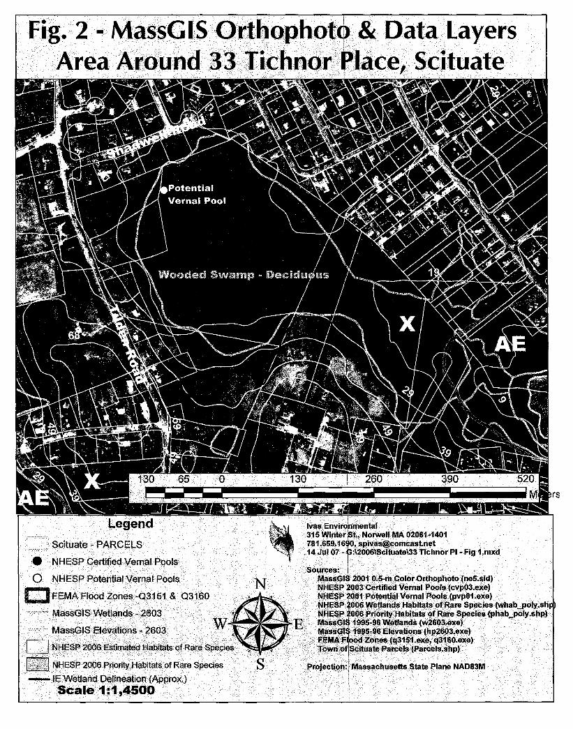
Fig. 2 - MassGIS Orthophottl» & Data LayersArea Around 331ichnor ~lace, Scituate
- ' -- 1 - - -,.
-'!'IIIl"["il
• NHESP Certified Vernal Pools
o NHESP Potential Vernal Pools
C FEMA Flood Zones-Q3151 & Q3160
MassG1SWetlands -'2603 .

This soil map is ad"ance information, subje-ct to changeupon the completion, correlation, and publication of thePlymouth Co., Mass. Soil Survey. This soil map is not SSUROcertified and has not been authorized for National release bythe USDA-NRCS. Soil delineations were made on unrectifiedcolor infrared aerial photos at a I :12,000 scale, minimumdelineations are 2-3 acres in size. For more into contact thePlymouth Co. Soil Survey at 508-295-5151, x 2.
Ivas Environmental315 Winter St., Norwell MA 02061-1401781.659.1690, [email protected]
Source: Tile 70-43.jpg, 2003 Plymouth Co.Draft Soil Maps, provided by NRCS formerstaff [, Turenne, now Soils Scientist, RI
G:\2007\Scituate\33 Tichnor PI-Fi 3-14juI07.cdr

G:\2007\Scituate\33 Tichnor PI-Fi 4-14 ul07.cdr
Fig. 4 - Site Locus33 Tichnor Place Scituate
UNITED STATESDEP-'~RTMENTOF THE INTERIOR
GEOLOGICAL: SIO OIJO rUT
Ivas Environmental315 Winter St., Norwell MA 02061-1401781.659.1690, [email protected]
STATE OF MASSACHUSETTSDE:P.ARTMENT OF :PUBLIC WORES
JOHN w. BEAL. CO:MM!SSIONER
Source: 1940 USGS ScituateTopographic QuadrangleNorthwest Portion

Exhibit AProposed Project Description
33 Tichnor Place, Scituate
The proposed project at 33 Tichnor Place includes two elements: a driveway within the 50-to-1 00 foot Buffer
Zone of a Bordering Vegetated Wetland (BVW) and a resource improvement project directly adjacent to the
same BVW.
The driveway is proposed to provide access to another single-family residence on the site. Both the proposed
residence and its wastewater disposal system are outside the Conservation Commission's jurisdiction. Please
review the attached plan, Kochman Residence, by Coyle and Caron, LLC, dated 03 Iul 07 for the locations of
the proposed residence and wastewater disposal system. The driveway is proposed as 12 feet wide, with a
crushed stone surface. A total of 1,300 sf of the driveway is proposed within the 1OO-foot buffer zone to the
BVW. The closest portion of the driveway to the BVW is about 75 feet.
The resource improvement project includes the development a 3,050 meadow along the BVW. This area
would continue the previous successful meadow creation further to the north. The previous resource
improvement work was the subject of another filing in 2002. That filing included the construction of a
driveway access from Tilden Road to the existing single-family residence, with the planting of additional
wildlife habitat in the form of a number of groupings of native shrubs and buffer zone meadow planting and
management.
The resource improvement project would include the planting of 80% New England Wetmix and 20%
wildflower mix from New England Wetland Plants, Inc., of Amherst, Massachusetts. It would also include the
relocation of 90 feet of stone wall, southerly of wetland delineation flag # IE A30. The stone wall shall be
relocated to the boundary between the existing and proposed single-family residences, and is shown on the
plan.
The resource improvement project would also include the planting of a dozen red maple trees, including two
within the 50-foot Buffer Zone to the BVW, six within the 50-to-1 00 foot Buffer Zone, and four outside the
buffer zone to the BVW, to provide for a wildlife habitat overstory connection to other site trees that are now
in an isolated grouping.
The BVW on and adjacent to the site is part of a large complex that is associated with an Intermittent Stream,
Granny's Brook, that flows into a tidal estuary at the intersection of Jericho and Hatherly Roads.
No impacts to the BVW are anticipated with the appropriate staging of crushed stone for the proposed
driveway. The project is designed to improve wildlife habitat values and functions of cover, food, breeding,
and nesting on site.
Alternatives:
The driveway alignment was chosen to conserve two on-site mature trees. Another alignment would result in
the cutting of at least one of these mature trees.

Map, Block & lot Address
45 - 7 - 1 Richfield Rd.
45 - 7 - 2 Richfield Rd.
45 - 6 - 9F 2 Richfield Rd.
45 - 6 - 7 7 Richfield Rd.
45 - 6 - 8 8 Richfield Rd.
45-6-1A 1 Seamore Rd.
45 - 6 - 1 1 Seamore Rd.
45-2-21 Tichnor Place45 - 2 - 2345 - 2 - 36
45 - 2 - 24 Tichnor Place
45 - 2 - 25 26 Tichnor Place
45 - 2 - 18 21 Tichnor Place
45 - 2 - 17 17 Tichnor Place
Exhibit B
Abutters list
33 Tichnor Place, Scituate
Mailing Address of Abutter(s)
Mary T. Martinello45 Ware Street, Mansfield MA 02048
Estelle & Richard Passeri160 Elm St. RFD, Byfield MA 01969
Kevin R. Shea2 Richfield Road, Scituate MA 02066
Walter E. & Lori [. McGinley1 Seamore Road, Scituate MA 02066
Rita W. Blanchard8 Richfield Road, Scituate MA 02066
Walter E. & Lori J. McGinley1 Seamore Road, Scituate MA 02066
Walter E. & Lori j. McGinley1 Seamore Road, Scituate MA 02066
Deborah Pike and Steven W. Emmett36 Tichnor Place, Scituate MA 02066
Gregg A. Phinney & Alyson j. Hall29 Tichnor Place, Scituate MA 02061
Daniel F. and Pamela jean Sullivan26 Tichnor Place, Scituate MA 02066
joseph W. & Diane j. Cirillo21 Tichnor Place, Scituate MA 02066
Samuel A. II and Roberta VillaniGo 1st American Tax Service8435 Stemons Freeway, Dallas TX 75847
45 - 2 - 16
45 - 2 - 17R
15 Tichnor Place
Tichnor Place
Richard C. Clay15 Tichnor Place, Scituate MA 02066
Gary Culkins & Hillary Williams96 Beaver Dam Road, Scituate MA 02066

45 - 2 - SA 94 Ti Iden Road Kimberly A. Carvell i-Marcia1517 West Ave, Richmond, VA 23220
45 - 2 - 4 100 Tilden Road Thomas J. Flaherty100 Tilden Road, Scituate MA 02066
45 - 2 - 2 104 Tilden Road Thomas M. & Deborah A. Kilduff108 Tilden Road, Scituate MA 02066
45 - 1- 4B 111 Tilden Road George N. & Marie Trafton111 Tilden Road, Scituate MA 02066
45 - 1 - 4A 117 Tilden Road Kathryn Ann Coscia, Trs.117 Tilden Road, Scituate MA 02066
45 - 2 - 1B 118 Tilden Road Mary A. Whitcomb118 Tilden Road, Scituate MA 02066
45 - 2 - 1 122 Tilden Road Matthew & Rosemary Brown122 Tilden Road, Scituate MA 02066
45-2-1A 126 Tilden Road Mary E. Graham126 Tilden Road, Scituate MA 02066
39 - 26 - 33G 132 Tilden Road Sean & Tamara O'Connor132 Tilden Road, Scituate MA 02066
45 - 2 - 1R Tilden Road Wm. & James Kochman, Trs.33 Tichnor Place, Scituate MA [APPLICANT]
39 - 26 - 32R 8 Ava's Lane Sam Tilden Farm LLC45 - 1 - 8F 189 Front Street, Scituate MA 0206639 - 27 - 6

· ExhibitCPerformance Standards Discussion
33 Tichnor Place, Scituate
1. Public Water Supply. There are not Public Water Supply wells down-gradient of the subject site:instead, the site drains to the Intermittent Stream, Granny's Brook, which flows into a tidal estuary atthe corner of Jericho and Hatherly Roads.
2. Private Water Supply. There are no private drinking water supply wells known in the vicinity of thesubject lot. There may be lawn irrigation well(s) in the surrounding area.
3. Groundwater. The two elements of the proposed project are a resource improvement and adriveway construction, neither of which has the capacity to affect the groundwater.
4. Groundwater Quality. Ibid.
5. Flood Control. No impacts to flood control are anticipated due to the transmissivity of the soils inthe area. The resource improvement and driveway shall both continue to allow infiltration into theground, and not affect the interest of flood control.
6. Storm Damage Prevention. Ibid.
7. Water Pollution Prevention. No impacts to the Intermittent Stream (Granny's Brook) that is wellwithin the the Bordering Vegetated Wetland are anticipated from the construction of the single-familyresidence addition.
6. Sedimentation and Erosion Control. The proposed silt fence (only) at the edge of the resourceimprovement area, and proper staging of soils for the construction of the driveway within theBordering Vegetated Wetland Buffer Zone should obviate any impacts on sedimentation and erosioncontrol.
7. Fisheries. There are no known fisheries known on or adjacent to the site. The stream, Granny'sBrook) within the BVW to the northwest of the site is an Intermittent Stream. Furthermore, theproposed project shall have no impact to the Intermittent Stream, so that when it joins the tidalestuary, down-gradient, in which there are fish, there shall be no impacts. Granny's Brook appears tobe tidal, as it flows through a pipe under the now or former Pier 44 Parking Lot from an area near thesouthwest corner of the now or former Satuit Tavern.
8. Shellfish. There are no known shellfish on or adjacent to the subject site: the nearest aredownstream, associated with the tidal estuary portion of Granny's Brook, as above. The proposedproject shall have no impact on the shellfish in the tidal estuary.
9. Wildlife and Wildlife Habitats. The proposed project is planned to improve wildlife habitat by two
methods. First, the development of an increased area of meadow, and second, by an increasedoverstory that connects the isolated overstory on site to the southwesterly to the Bordering Vegetated
Wetland.
Other Interests that are brought up by the Commission include the following:
10. Recreation. The parcel is under private ownership, therefore there are no public recreational
interests involved in the proposed project.