Embed Size (px)
Citation preview
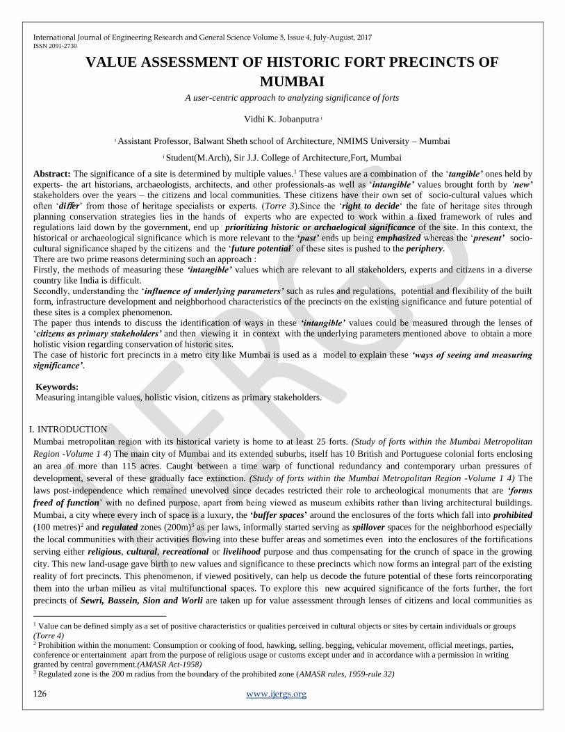
International Journal of Engineering Research and General Science Volume 5, Issue 4, July-August, 2017 ISSN 2091-2730
126 www.ijergs.org
VALUE ASSESSMENT OF HISTORIC FORT PRECINCTS OF
MUMBAI A user-centric approach to analyzing significance of forts
Vidhi K. Jobanputra
Assistant Professor, Balwant Sheth school of Architecture, NMIMS University – Mumbai
Student(M.Arch), Sir J.J. College of Architecture,Fort, Mumbai
Abstract: The significance of a site is determined by multiple values.1 These values are a combination of the ‘tangible’ ones held by
experts- the art historians, archaeologists, architects, and other professionals-as well as ‘intangible’ values brought forth by ‘new’
stakeholders over the years – the citizens and local communities. These citizens have their own set of socio-cultural values which
often ‘differ’ from those of heritage specialists or experts. (Torre 3).Since the ‘right to decide‘ the fate of heritage sites through
planning conservation strategies lies in the hands of experts who are expected to work within a fixed framework of rules and
regulations laid down by the government, end up prioritizing historic or archaelogical significance of the site. In this context, the
historical or archaeological significance which is more relevant to the ‘past’ ends up being emphasized whereas the ‘present’ socio-
cultural significance shaped by the citizens and the ‘future potential’ of these sites is pushed to the periphery.
There are two prime reasons determining such an approach :
Firstly, the methods of measuring these ‘intangible’ values which are relevant to all stakeholders, experts and citizens in a diverse
country like India is difficult.
Secondly, understanding the ‘influence of underlying parameters’ such as rules and regulations, potential and flexibility of the built
form, infrastructure development and neighborhood characteristics of the precincts on the existing significance and future potential of
these sites is a complex phenomenon.
The paper thus intends to discuss the identification of ways in these ‘intangible’ values could be measured through the lenses of
‘citizens as primary stakeholders’ and then viewing it in context with the underlying parameters mentioned above to obtain a more
holistic vision regarding conservation of historic sites.
The case of historic fort precincts in a metro city like Mumbai is used as a model to explain these ‘ways of seeing and measuring
significance’.
Keywords:
Measuring intangible values, holistic vision, citizens as primary stakeholders.
I. INTRODUCTION
Mumbai metropolitan region with its historical variety is home to at least 25 forts. (Study of forts within the Mumbai Metropolitan
Region -Volume 1 4) The main city of Mumbai and its extended suburbs, itself has 10 British and Portuguese colonial forts enclosing
an area of more than 115 acres. Caught between a time warp of functional redundancy and contemporary urban pressures of
development, several of these gradually face extinction. (Study of forts within the Mumbai Metropolitan Region -Volume 1 4) The
laws post-independence which remained unevolved since decades restricted their role to archeological monuments that are ‘forms
freed of function’ with no defined purpose, apart from being viewed as museum exhibits rather than living architectural buildings.
Mumbai, a city where every inch of space is a luxury, the ‘buffer spaces’ around the enclosures of the forts which fall into prohibited
(100 metres)2 and regulated zones (200m)3 as per laws, informally started serving as spillover spaces for the neighborhood especially
the local communities with their activities flowing into these buffer areas and sometimes even into the enclosures of the fortifications
serving either religious, cultural, recreational or livelihood purpose and thus compensating for the crunch of space in the growing
city. This new land-usage gave birth to new values and significance to these precincts which now forms an integral part of the existing
reality of fort precincts. This phenomenon, if viewed positively, can help us decode the future potential of these forts reincorporating
them into the urban milieu as vital multifunctional spaces. To explore this new acquired significance of the forts further, the fort
precincts of Sewri, Bassein, Sion and Worli are taken up for value assessment through lenses of citizens and local communities as
1 Value can be defined simply as a set of positive characteristics or qualities perceived in cultural objects or sites by certain individuals or groups
(Torre 4) 2 Prohibition within the monument: Consumption or cooking of food, hawking, selling, begging, vehicular movement, official meetings, parties,
conference or entertainment apart from the purpose of religious usage or customs except under and in accordance with a permission in writing
granted by central government.(AMASR Act-1958) 3 Regulated zone is the 200 m radius from the boundary of the prohibited zone (AMASR rules, 1959-rule 32)
International Journal of Engineering Research and General Science Volume 5, Issue 4, July-August, 2017 ISSN 2091-2730
127 www.ijergs.org
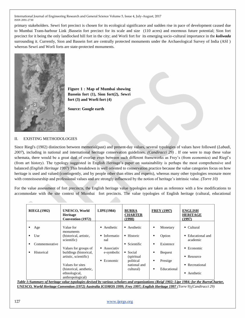
primary stakeholders. Sewri fort precinct is chosen for its ecological significance and sudden rise in pace of development caused due
to Mumbai Trans-harbour Link ;Bassein fort precinct for its scale and size (110 acres) and enormous future potential; Sion fort
precinct for it being the only landlocked hill fort in the city; and Worli fort for its emerging socio-cultural importance in the koliwada
surrounding it. Currently, Sion and Bassein fort are centrally protected monuments under the Archaeological Survey of India (ASI )
whereas Sewri and Worli forts are state-protected monuments.
II. EXISTING METHODOLOGIES
Since Riegl's (1902) distinction between memorial(past) and present-day values, several typologies of values have followed (Labadi,
2007), including in national and international heritage conservation guidelines. (Candiracci 29) . If one were to map these value
schemata, there would be a great deal of overlap even between such different frameworks as Frey’s (from economics) and Riegl’s
(from art history). The typology suggested in English Heritage’s paper on sustainability is perhaps the most comprehensive and
balanced (English Heritage 1997) This breakdown is well oriented to conservation practice because the value categories focus on how
heritage is used and valued (contingently, and by people other than elites and experts), whereas many other typologies resonate more
with connoisseurship and professional values and are strongly influenced by the notion of heritage’s intrinsic value. (Torre 10)
For the value assessment of fort precincts, the English heritage value typologies are taken as reference with a few modifications to
accommodate with the site context of Mumbai fort precincts. The value typologies of English heritage (cultural, educational
RIEGL(1902)
UNESCO, World
Heritage
Convention (1972)
LIPE(1984)
BURRA
CHARTER
(1998)
FREY (1997)
ENGLISH
HERITAGE
(1997)
Age
Use
Commemorative
Historical
Value for
monuments
(historical, artistic,
scientific)
Values for groups of
buildings (historical,
artistic, scientific)
Values for sites
(historical, aesthetic,
ethnological,
anthropological)
Aesthetic
Informatio
nal
Associativ
e-symbolic
Economic
Aesthetic
Historic
Scientific
Social
(spiritual
political
national and
cultural)
Monetary
Option
Existence
Bequest
Prestige
Educational
Cultural
Educational and
academic
Economic
Resource
Recreational
Aesthetic
Table 1:Summary of heritage value typologies devised by various scholars and organizations (Reigl 1902; Lipe 1984; for the BurraCharter,
UNESCO, World Heritage Convention (1972) Australia ICOMOS 1999; Frey 1997; English Heritage 1997 (Torre 9) (Candiracci 29)
Figure 1 : Map of Mumbai showing
Bassein fort (1), Sion fort(2), Sewri
fort (3) and Worli fort (4)
Source: Google earth
International Journal of Engineering Research and General Science Volume 5, Issue 4, July-August, 2017 ISSN 2091-2730
128 www.ijergs.org
economic, resource, recreational and aesthetic) are revised as socio-cultural, educational monetary, recreational and aesthetic values
(economic and resource value are clubbed together as monetary value).
III. VALUE ASSESSMENT OF FORT PRECINCTS
a) METHODOLOGY
An on-field survey Questionnaire with a total of 23 statements was used for evaluating the significance of each precinct from the
citizens perspective. The citizens on the site were expected to give their opinion on how strongly do they agree/disagree with these 23
statements on a rating scale of 0 to 3. All 23 statements were broadly classified into 4 categories with each one belonging to one of the
categories4-Educational(6 statements), Socio-cultural (5 statements), recreational (8 statements)or Aesthetic (4 statements).
Each Statement in every category/value was framed with a purpose of measuring a specific important attribute of that particular value
.( refer table 2 for list of attributes under each category of value).
For example, for measuring the Recreational value, a few statements were :
o This place is safe for me to spend time alone (measuring safety/security)
o I find it very easy to move around here without using google maps or asking other people about directions. (measuring Legibility)
o I find this place very comfortable to visit even in hot afternoon sun.(measuring Physical Comfort)
Similarly, for measuring educational value, a few statements were:
o This place offers knowledge that is not available through any other resources like internet,books,etc (measuring rare source of
knowledge)
o This place offers something to learn for everyone irrespective of age, sex and occupation.( Measuring relevance of knowledge to
all age groups, gender and occupation)
The survey was carried out multiple times with stratified random sampling for reliable results.
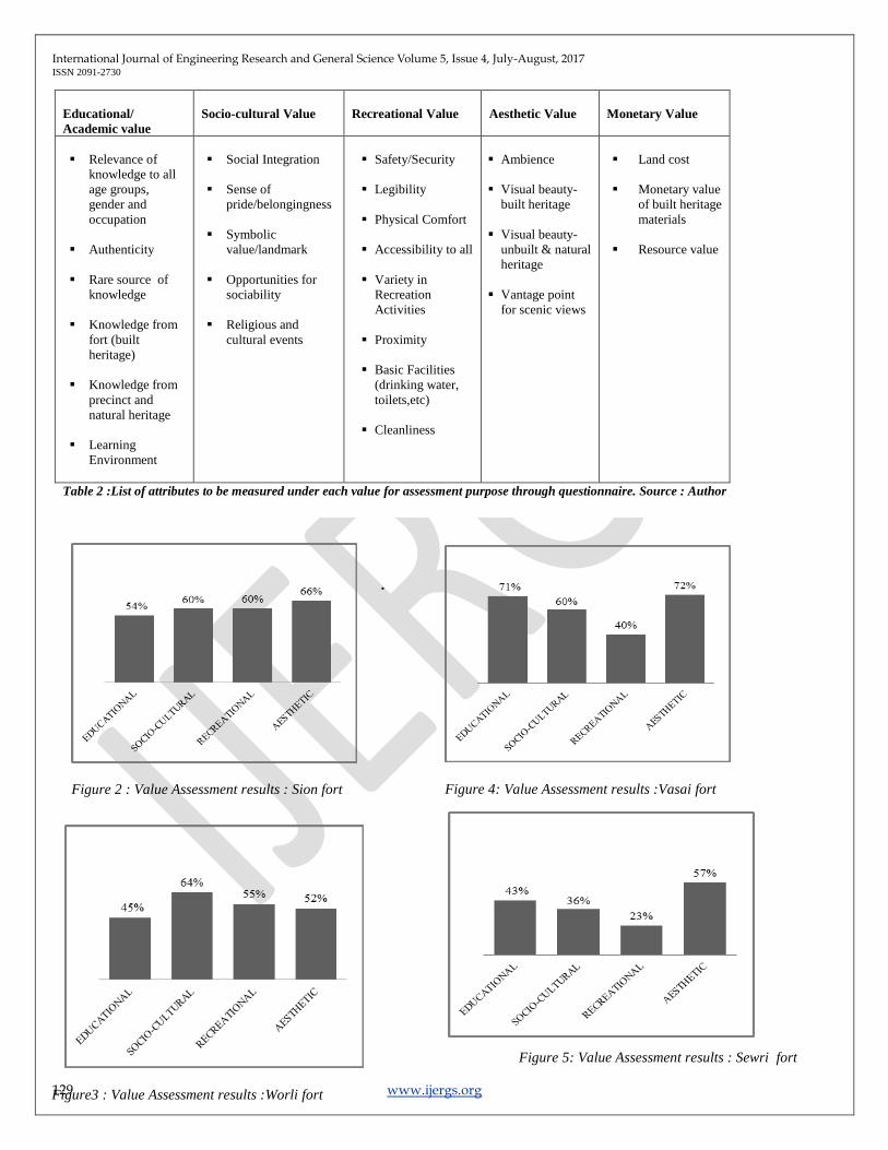
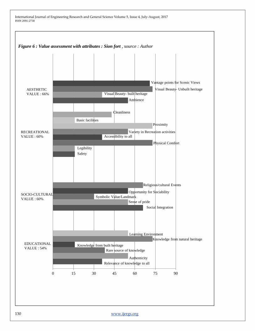
b) FINDINGS
Based on the scores obtained, a percentage value assessment was obtained for each fort ( refer Figure 2,3,4 and 5). A detailed value
assessment with attributes is given in Figure 6 based on citizens opinions.
4 Monetary value of land is assessed through interaction with experts. Since this paper deals with value assessment from citizen’s perspective, results
of monetary value are not a part of this paper.
International Journal of Engineering Research and General Science Volume 5, Issue 4, July-August, 2017 ISSN 2091-2730
129 www.ijergs.org
Educational/
Academic value
Socio-cultural Value
Recreational Value
Aesthetic Value
Monetary Value
Relevance of
knowledge to all
age groups,
gender and
occupation
Authenticity
Rare source of
knowledge
Knowledge from
fort (built
heritage)
Knowledge from
precinct and
natural heritage
Learning
Environment
Social Integration
Sense of
pride/belongingness
Symbolic
value/landmark
Opportunities for
sociability
Religious and
cultural events
Safety/Security
Legibility
Physical Comfort
Accessibility to all
Variety in
Recreation
Activities
Proximity
Basic Facilities
(drinking water,
toilets,etc)
Cleanliness
Ambience
Visual beauty-
built heritage
Visual beauty-
unbuilt & natural
heritage
Vantage point
for scenic views
Land cost
Monetary value
of built heritage
materials
Resource value
Table 2 :List of attributes to be measured under each value for assessment purpose through questionnaire. Source : Author
Figure 2 : Value Assessment results : Sion fort
Figure3 : Value Assessment results :Worli fort
Figure 5: Value Assessment results : Sewri fort
Figure 4: Value Assessment results :Vasai fort
.
International Journal of Engineering Research and General Science Volume 5, Issue 4, July-August, 2017 ISSN 2091-2730
130 www.ijergs.org
Figure 6 : Value assessment with attributes : Sion fort , source : Author
0 15 30 45 60 75 90
SOCIO-CULTURAL
VALUE : 60%
EDUCATIONAL
VALUE : 54%
RECREATIONAL
VALUE : 60%
AESTHETIC
VALUE : 66%
Relevance of knowledge to all
Authenticity
Rare source of knowledge
Knowledge from built heritage
Knowledge from natural heritage
Learning Environment
Social Integration
Sense of pride
Symbolic Value/Landmark
Opportunity for Sociability
Religious/cultural Events
Safety
Legibility
Physical Comfort
Accessibility to all
Variety in Recreation activities
Proximity
Basic facilities
Cleanliness
Ambience
Visual Beauty- built heritage
Visual Beauty- Unbuilt heritage
Vantage points for Scenic Views
International Journal of Engineering Research and General Science Volume 5, Issue 4, July-August, 2017 ISSN 2091-2730
131 www.ijergs.org
IV. THE HOLISTIC APPROACH:
After the value assessment, the following questions were explored in order to understand the cause and the effect to these existing
values.
1) What caused/allowed the emergence of these values?
2) Why do these values continue to thrive?
3) Are these values co-existent at a particular point in time?
4) Will they continue to thrive in future?
The ‘parameters’ identified in a process to understand answers to these
questions were then studied in detail. The parameters identified were as
follows:
A. SPATIAL CONFIGURATION/BUILT FORM:
Figure 7 : Schematic Plan of Sion Fort
Source :
Abandoned Treasures-Forts of Mumbai (book)
The built form along with the shape of its enclosures determines the kind
of function it can allow. For instance, In case of Sion hill fort, the built
form comprises of a number of chambers-each chamber of the size and
volume of a habitable room. The fort has more than 12 such chambers.
The volume thus has a good potential for activities involving social
interaction at a more personal level. Currently, the precinct being a home
to many schools, the chambers are used for group study by students . the
fort is also popular amongst youngsters as they hold dance and music
rehersals in small groups.
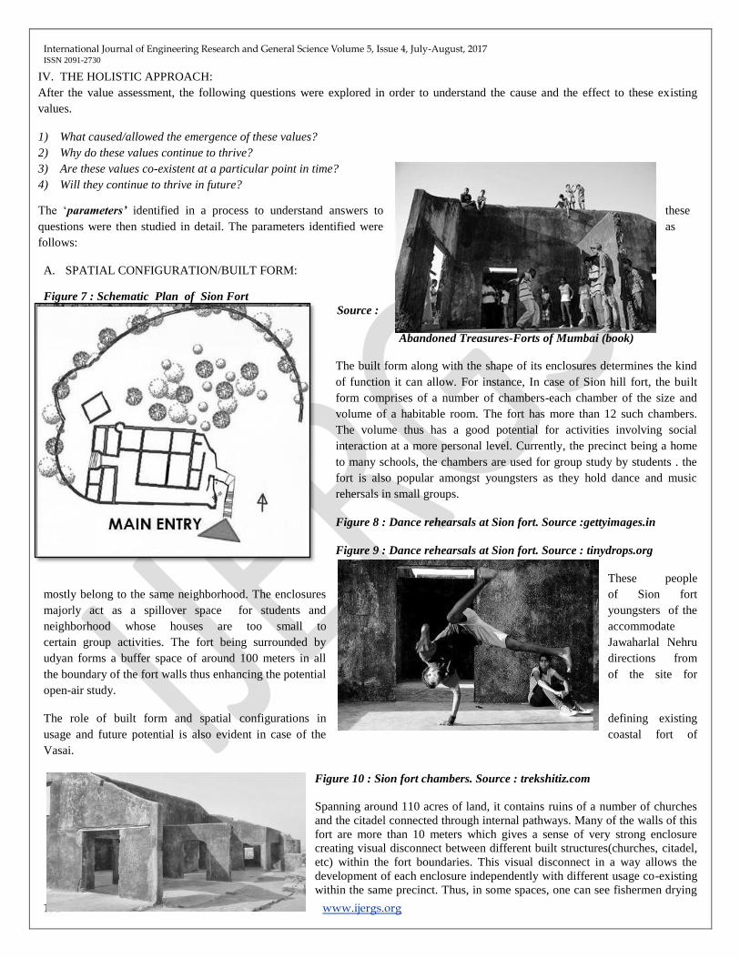
Figure 8 : Dance rehearsals at Sion fort. Source :gettyimages.in
Figure 9 : Dance rehearsals at Sion fort. Source : tinydrops.org
These people
mostly belong to the same neighborhood. The enclosures of Sion fort
majorly act as a spillover space for students and youngsters of the
neighborhood whose houses are too small to accommodate
certain group activities. The fort being surrounded by Jawaharlal Nehru
udyan forms a buffer space of around 100 meters in all directions from
the boundary of the fort walls thus enhancing the potential of the site for
open-air study.
The role of built form and spatial configurations in defining existing
usage and future potential is also evident in case of the coastal fort of
Vasai.
Figure 10 : Sion fort chambers. Source : trekshitiz.com
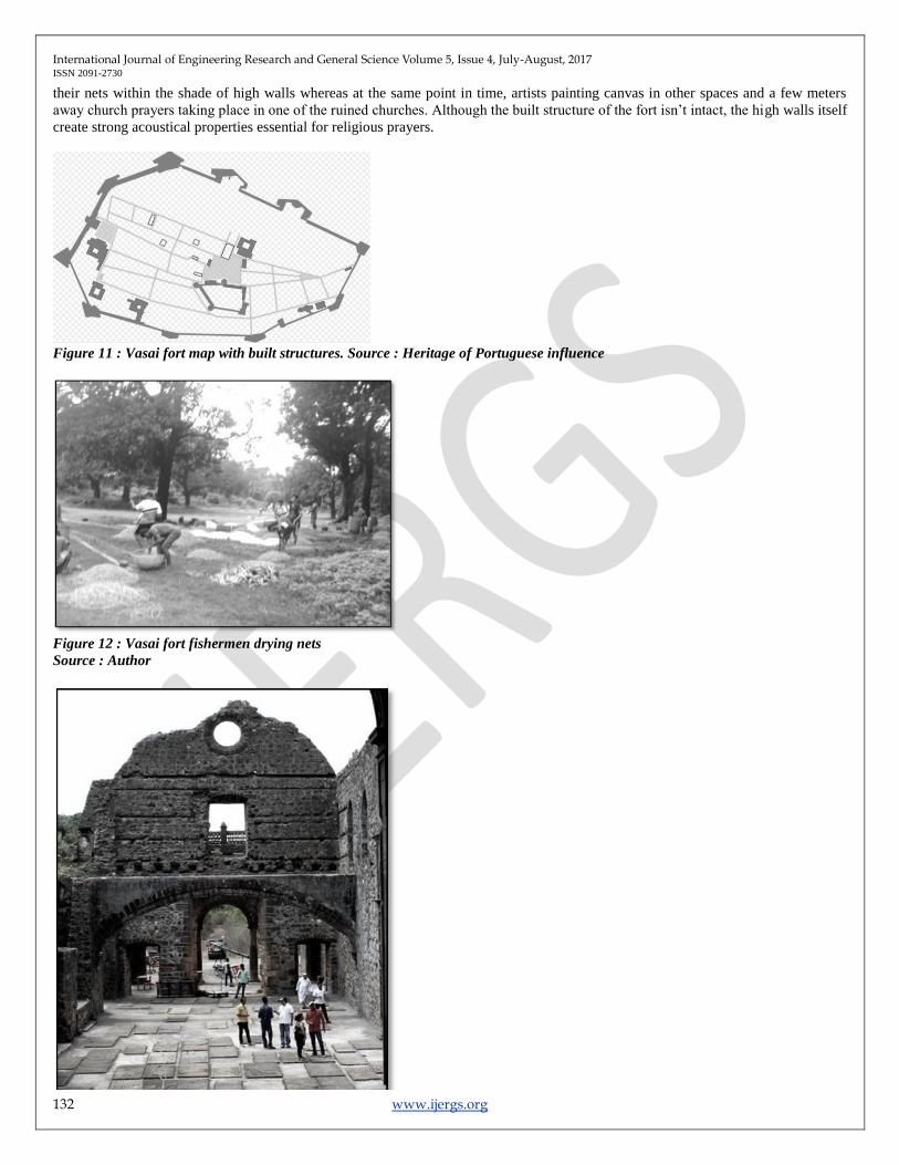
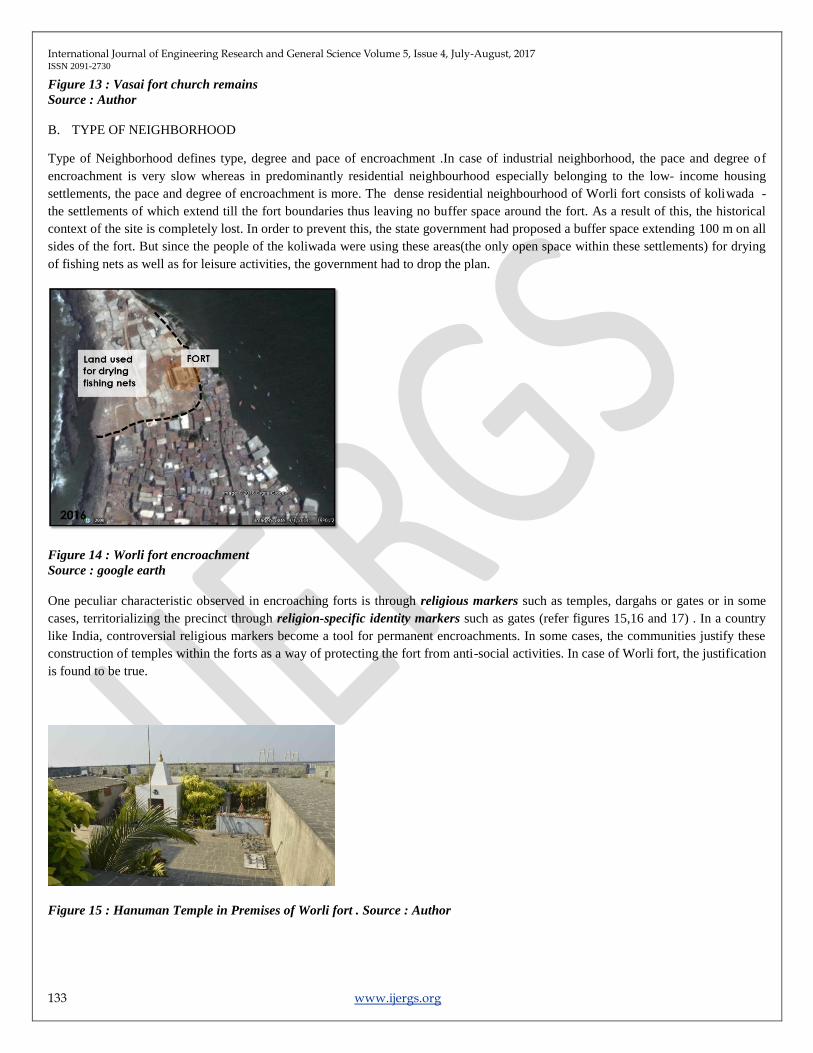
Spanning around 110 acres of land, it contains ruins of a number of churches
and the citadel connected through internal pathways. Many of the walls of this
fort are more than 10 meters which gives a sense of very strong enclosure
creating visual disconnect between different built structures(churches, citadel,
etc) within the fort boundaries. This visual disconnect in a way allows the
development of each enclosure independently with different usage co-existing
within the same precinct. Thus, in some spaces, one can see fishermen drying
International Journal of Engineering Research and General Science Volume 5, Issue 4, July-August, 2017 ISSN 2091-2730
132 www.ijergs.org
their nets within the shade of high walls whereas at the same point in time, artists painting canvas in other spaces and a few meters
away church prayers taking place in one of the ruined churches. Although the built structure of the fort isn’t intact, the high walls itself
create strong acoustical properties essential for religious prayers.
Figure 11 : Vasai fort map with built structures. Source : Heritage of Portuguese influence
Figure 12 : Vasai fort fishermen drying nets
Source : Author
International Journal of Engineering Research and General Science Volume 5, Issue 4, July-August, 2017 ISSN 2091-2730
133 www.ijergs.org
Figure 13 : Vasai fort church remains
Source : Author
B. TYPE OF NEIGHBORHOOD
Type of Neighborhood defines type, degree and pace of encroachment .In case of industrial neighborhood, the pace and degree of
encroachment is very slow whereas in predominantly residential neighbourhood especially belonging to the low- income housing
settlements, the pace and degree of encroachment is more. The dense residential neighbourhood of Worli fort consists of koliwada -
the settlements of which extend till the fort boundaries thus leaving no buffer space around the fort. As a result of this, the historical
context of the site is completely lost. In order to prevent this, the state government had proposed a buffer space extending 100 m on all
sides of the fort. But since the people of the koliwada were using these areas(the only open space within these settlements) for drying
of fishing nets as well as for leisure activities, the government had to drop the plan.
Figure 14 : Worli fort encroachment
Source : google earth
One peculiar characteristic observed in encroaching forts is through religious markers such as temples, dargahs or gates or in some
cases, territorializing the precinct through religion-specific identity markers such as gates (refer figures 15,16 and 17) . In a country
like India, controversial religious markers become a tool for permanent encroachments. In some cases, the communities justify these
construction of temples within the forts as a way of protecting the fort from anti-social activities. In case of Worli fort, the justification
is found to be true.
Figure 15 : Hanuman Temple in Premises of Worli fort . Source : Author
International Journal of Engineering Research and General Science Volume 5, Issue 4, July-August, 2017 ISSN 2091-2730
134 www.ijergs.org
Figure 16 : Dargah touching the sewri fort wall . Source : Google earth
Figure 17 : Entry to Mahim fort (now completely encroached by slums) marked by gate of religious symbolism . Source : Google
earth, Author
C. INFRASTRUCTURE DEVELOPMENT/FUTURE PROJECTS :
Study of infrastructure development and future projects determine the changing urban fabric of the precinct over the years.one way of
studying this is through study development plans of the region. Any kind of infrastructure development has the power to dramatically
change the pace of development in any precinct. Sometimes, the connectivity through infrastructure (railways,sealink,etc) brings in
more people to the sites making them less derelict whereas in some cases , it makes the sites more vulnerable and is a threat to their
existence. In case of Sewri fort precinct, the construction of Mumbai Trans-harbor link (refer figure 18,) may destroy the ecological
importance of the site by intervening the natural habitat of mudflats for flamingos.In addition to this, it may also dramatically increase
the pace of development in the zone. The fort precinct of Sewri thus calls for design interventions to save the context of the heritage
on a priority basis.

International Journal of Engineering Research and General Science Volume 5, Issue 4, July-August, 2017 ISSN 2091-2730
135 www.ijergs.org
Figure 18 : Prroposed Mumbai Trans-harbour Link (red) connecting Eastern coast to Nhava Sena port passing through Sewri
Mudflats (Rane 2)
D. OWNERSHIP AND THEIR APPROACH
Ownership determines the approach and the budget under which development takes place within the forts. Centrally protected
monuments have strict rules of prohibiting and development within 100 m radius of the fort boundaries. As a result of which, site
context is preserved. Whereas in case of state protected monuments such as Dharavi, Mahim and Worli forts, there are no such rules
implemented. This leniency makes the sites vulnerable to encroachments.
E. SITE TOPOGRAPHY
Topography defines the microclimate as well as the accessibility factor. For instance, the hill fort of Sion is less accessible to senior
Citizens.Thus ,the usage of the fort structure is restricted to youngsters and children for whom its easier to climb and access the hill
fort.
V. CONCLUSION
The fort studies need a comprehensive study of ground realities, future infrastructure projects and most importantly the cultural
significance of the site understand the current and future potential of forts in addition to the historical study. In the process, a wide
range of heritage values need to be identified and characterized in a way that is relevant to all stakeholders involved. It is self-evident
that no society makes an effort to conserve what it does not value. Until all the stakeholders don’t value a place, all efforts to in will
be futile (Torre 3)
To ensure public participation and economic sustenance of the sites, there is an urgent need for innovative strategies that monetize
these precincts without disturbing the historical significance of the site. Adaptive reuse, strategically planned access roads and
navigation patterns within the precinct, defining buffer spaces around forts with strong physical boundaries such as trees instead of
mental boundaries of 100 m prohibited zones may be some of the strategies that can work for these forts.
The value assessment methodology mentioned in the paper have resulted from site context of selected sites. The methodology needs to
be verified further for their pertinent applicability to other similar sites. This methodology showed difficulties in being implemented at
a derelict site of restricted access like Sewri fort and its sparsely populated precinct.
International Journal of Engineering Research and General Science Volume 5, Issue 4, July-August, 2017 ISSN 2091-2730
136 www.ijergs.org
VI. ACKNOWLEDGEMENT
I profoundly thank the institute of Sir J.J College of Architecture, especially professors Mustansir Dalvi, Sushma Joglekar and Parul
Kumtha for their constant guidance and support during the research.
REFERENCES:
1. Academy of Architecture. Study of forts within the Mumbai Metropolitan Region -Volume 1. Mumbai: MMR- HCS, 2003.
2. Candiracci, Sara. Developing a methodology for a landscape-based approach to urban conservation in sub-saharan Africa.
Thesis. Italy: University of Naples Federico II, 2016.
3. FOUNDATION, NAGAR. Abandoned Treasures- Forts of Mumbai. Mumbai, 2015.
4. India, Archaelogical Survey of. "The Ancient Monuments and Archaeological Sites and Remains Act." 1958.
5. Maharashtra, Government of. "The Maharashtra Ancient monuments and Archaelogical sites and remains act." 1960.
6. Manders Martijn R, Van Tilburg Hans K. , Staniforth Mark. Significance Assessment. Bangkok: UNESCO, 2012.
7. Mumbai, Muncipal Corporation of Greater. Development plan. Mumbai, 1981.
8. Mumbai, Municipal Corporation of Greater. Development plan . Mumbai, 2016.
9. Rane, Amol. "Sewri Ecological Park:A proposal for sustainable waterfront development at eastern bay of Mumbai." Thesis.
2012.
10. Roders, Ana Pereira. "Monitoring cultural significance and impact assessments." International Association for Impact
Assessment (IAIA). 2013, n.d.
11. Torre, Marta De La. Assessing the values of cultural heritage. Los Angeles: The Getty Conservation Institute, 2002.