Embed Size (px)
Citation preview

April 27, 2018
Alan R. Dragoo [email protected] ©2018
Page 1
Understanding Least Squares Adjustment For Conventional Measurements
Instructor:Alan R. Dragoo
Maser Consulting PA2018 Spring Technical Conference
April 27, 2018Maritime Institute of TechnologyLinthicum Heights, Maryland
Alan R. Dragoo [email protected] ©2018
Topics to Be Covered:
• 2016 Accuracy Standards for ALTA/NSPS Land Title Surveys
• What is a least squares adjustment.
• How does least squares work.
• Define some terms in the field of statistics.
• Advantages of a least squares adjustment.
• The process of setting up a least squares adjustment.
• What are positional tolerances and how do they work.
2
April 27, 2018
Alan R. Dragoo [email protected] ©2018
Page 2
Alan R. Dragoo [email protected] ©2018
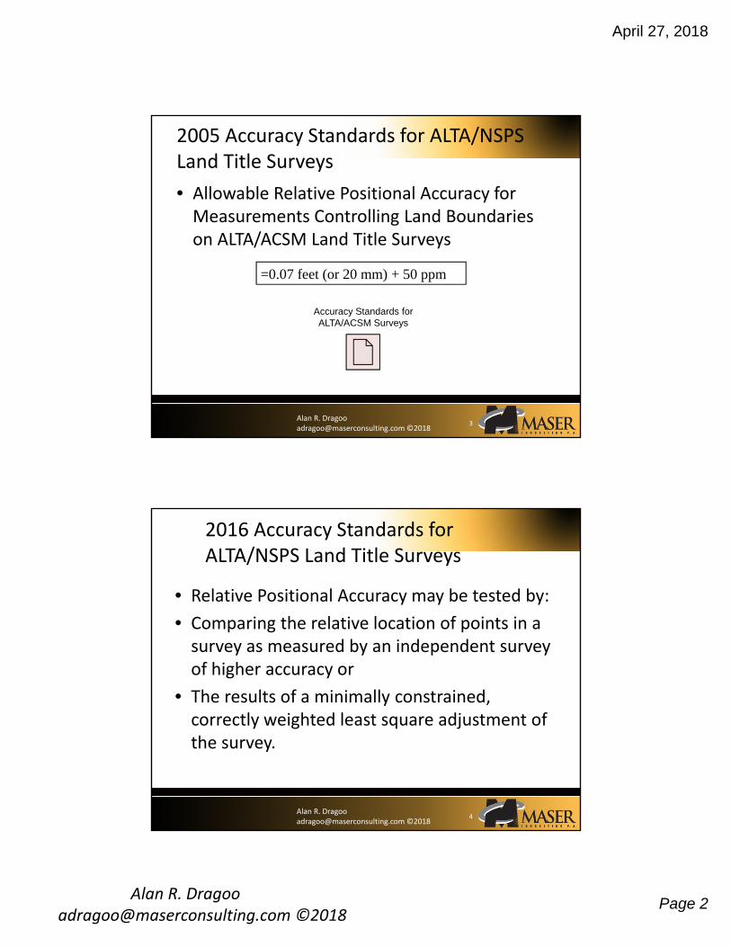
• Allowable Relative Positional Accuracy for Measurements Controlling Land Boundaries on ALTA/ACSM Land Title Surveys
2005 Accuracy Standards for ALTA/NSPS Land Title Surveys
3
=0.07 feet (or 20 mm) + 50 ppm
Accuracy Standards for ALTA/ACSM Surveys
Alan R. Dragoo [email protected] ©2018
2016 Accuracy Standards for ALTA/NSPS Land Title Surveys
• Relative Positional Accuracy may be tested by:
• Comparing the relative location of points in a survey as measured by an independent survey of higher accuracy or
• The results of a minimally constrained, correctly weighted least square adjustment of the survey.
4
April 27, 2018
Alan R. Dragoo [email protected] ©2018
Page 3
Alan R. Dragoo [email protected] ©2018
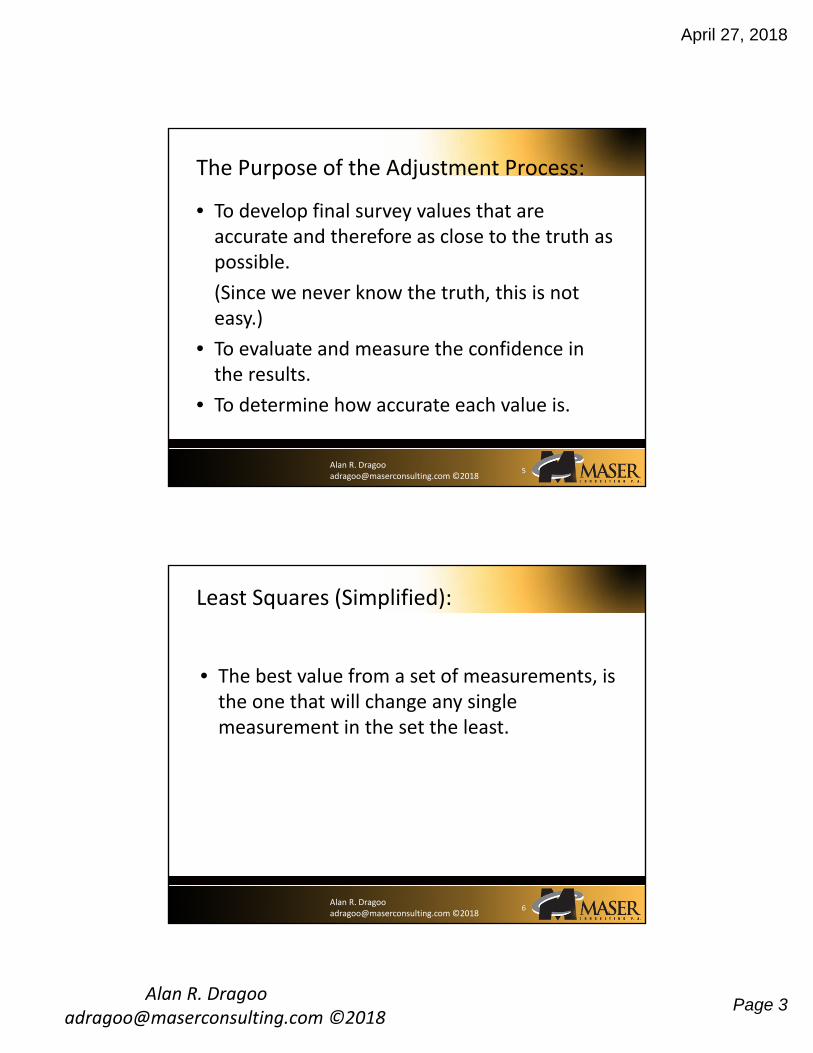
• To develop final survey values that are accurate and therefore as close to the truth as possible.
(Since we never know the truth, this is not easy.)
• To evaluate and measure the confidence in the results.
• To determine how accurate each value is.
The Purpose of the Adjustment Process:
5
Alan R. Dragoo [email protected] ©2018
Least Squares (Simplified):
• The best value from a set of measurements, is the one that will change any single measurement in the set the least.
6
April 27, 2018
Alan R. Dragoo [email protected] ©2018
Page 4
Alan R. Dragoo [email protected] ©2018
DISTDIFFERENCE FROM ADJ. DIFF2 DIFFERENCE
FROM ADJ. DIFF2 DIFFERENCE FROM ADJ. DIFF2
500.01 +0.01 0.01 0.00 0.00 -0.02 0.04500.02 +0.02 0.04 +0.01 0.01 -0.03 0.09499.99 -0.01 0.01 -0.02 0.04 0.00 0.00499.98 -0.02 0.04 -0.03 0.09 -0.01 0.01500.00 0.00 0.00 -0.01 0.01 +0.01 0.01499.99 -0.01 0.01 -0.02 0.04 0.00 0.00500.01 +0.01 0.01 0.00 0.00 +0.02 0.04500.00 0.00 0.00 -0.01 0.01 +0.01 0.01500.00 0.00 0.00 -0.01 0.01 +0.01 0.01Totals: 0.12 0.21 0.21
Most probable value chosen
500.00 500.01 499.99
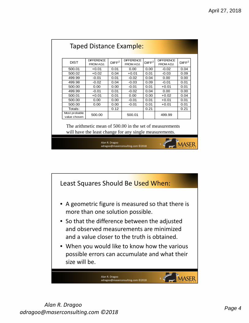
Taped Distance Example:
The arithmetic mean of 500.00 in the set of measurements will have the least change for any single measurements.
7
Alan R. Dragoo [email protected] ©2018
Least Squares Should Be Used When:
• A geometric figure is measured so that there is more than one solution possible.
• So that the difference between the adjusted and observed measurements are minimized and a value closer to the truth is obtained.
• When you would like to know how the various possible errors can accumulate and what their size will be.
8
April 27, 2018
Alan R. Dragoo [email protected] ©2018
Page 5
Alan R. Dragoo [email protected] ©2018
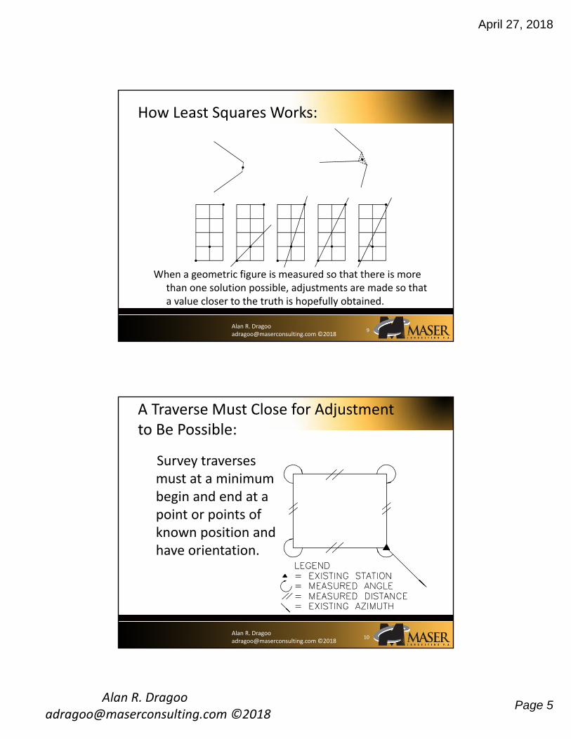
How Least Squares Works:
When a geometric figure is measured so that there is more than one solution possible, adjustments are made so that a value closer to the truth is hopefully obtained.
9
Alan R. Dragoo [email protected] ©2018
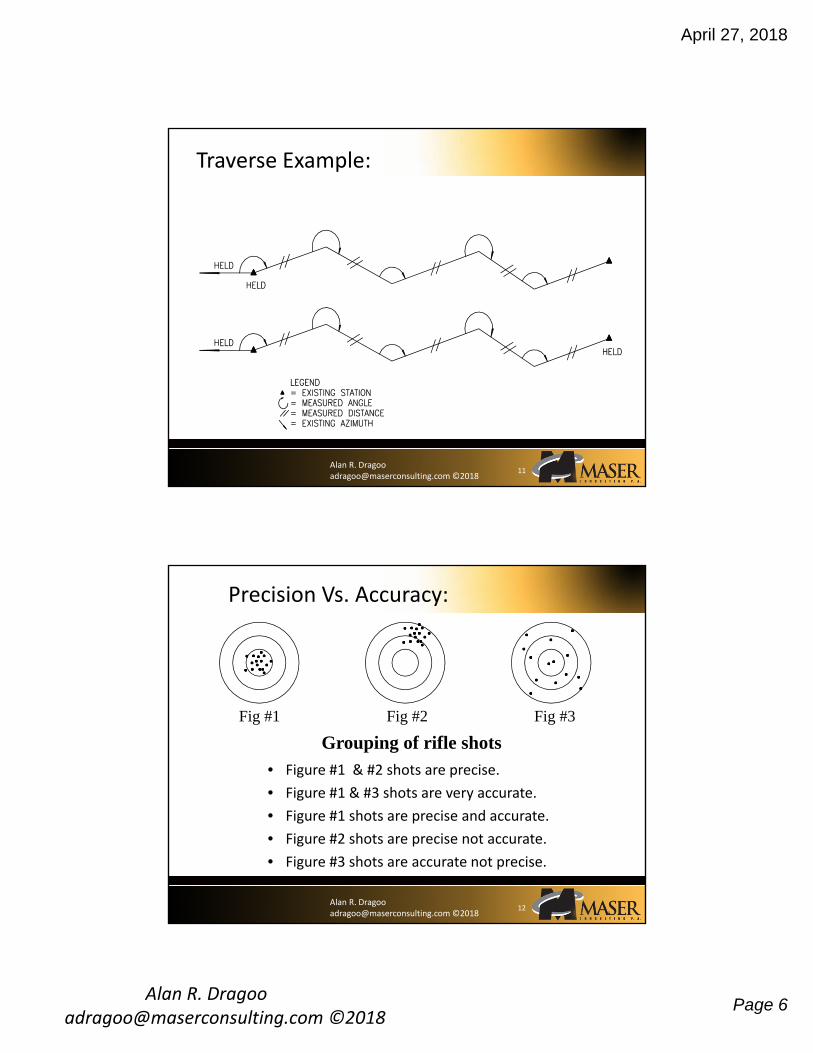
A Traverse Must Close for Adjustment to Be Possible:
Survey traverses must at a minimum begin and end at a point or points of known position and have orientation.
10
April 27, 2018
Alan R. Dragoo [email protected] ©2018
Page 6
Alan R. Dragoo [email protected] ©2018
Traverse Example:
11
Alan R. Dragoo [email protected] ©2018
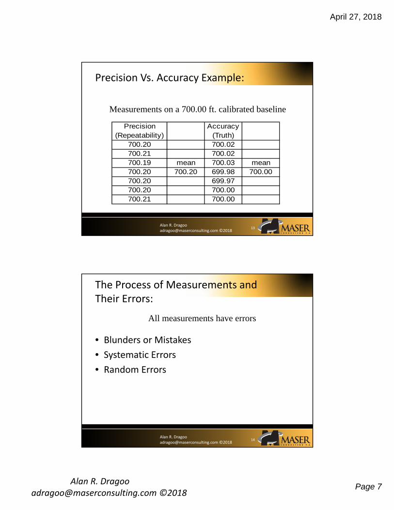
Precision Vs. Accuracy:
• Figure #1 & #2 shots are precise.
• Figure #1 & #3 shots are very accurate.
• Figure #1 shots are precise and accurate.
• Figure #2 shots are precise not accurate.
• Figure #3 shots are accurate not precise.
Fig #1 Fig #2 Fig #3
Grouping of rifle shots
12
April 27, 2018
Alan R. Dragoo [email protected] ©2018
Page 7
Alan R. Dragoo [email protected] ©2018
Precision Vs. Accuracy Example:
Precision (Repeatability)
Accuracy (Truth)
700.20 700.02700.21 700.02700.19 mean 700.03 mean700.20 700.20 699.98 700.00700.20 699.97700.20 700.00700.21 700.00
Measurements on a 700.00 ft. calibrated baseline
13
Alan R. Dragoo [email protected] ©2018
• Blunders or Mistakes
• Systematic Errors
• Random Errors
The Process of Measurements and Their Errors:
All measurements have errors
14

April 27, 2018
Alan R. Dragoo [email protected] ©2018
Page 8
Alan R. Dragoo [email protected] ©2018
Causes of Systematic Errors
• Instruments not being properly calibrated or adjusted
• Environmental conditions
15
Alan R. Dragoo [email protected] ©2018
Random Error Causes
• The inability for anyone to perceive anything with exactness.
• Unpredictable fluctuations in environmental conditions.
• Unpredictable instrumental fluctuations.
16

April 27, 2018
Alan R. Dragoo [email protected] ©2018
Page 9
Alan R. Dragoo [email protected] ©2018
Words to Live By
• There is good luck and bad luck in all survey measurements, but if errors are not controlled and managed you will not have good luck.
• Alan Dragoo
17
Alan R. Dragoo [email protected] ©2018
Statistics for Surveyors:
A mathematical process that can be used to evaluate the quality of measurements.
18
April 27, 2018
Alan R. Dragoo [email protected] ©2018
Page 10
Alan R. Dragoo [email protected] ©2018
• Mean
– The true value of any measurement is never really known.
– For any set of measurements that has had the blunders and systematic errors removed the arithmetic mean is the best most probable value, to represent the true value.
• Residual
– The difference between a single value in a set of measurements from what is accepted as true.
Definitions & Concepts of Statistical Terms:
19
Alan R. Dragoo [email protected] ©2018
• Laws of Probability State
– Large errors seldom occur
– Small errors occur more often
– There is an equal chance of positive errors as negative errors
Definitions & Concepts of Statistical Terms Continued:
20
April 27, 2018
Alan R. Dragoo [email protected] ©2018
Page 11
Alan R. Dragoo [email protected] ©2018
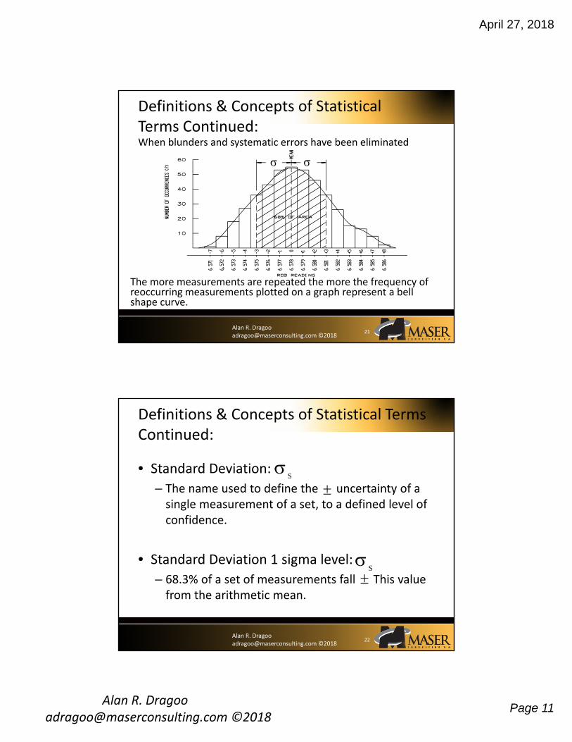
When blunders and systematic errors have been eliminated
Definitions & Concepts of Statistical Terms Continued:
The more measurements are repeated the more the frequency of reoccurring measurements plotted on a graph represent a bell shape curve.
21
Alan R. Dragoo [email protected] ©2018
• Standard Deviation:
– The name used to define the uncertainty of a single measurement of a set, to a defined level of confidence.
• Standard Deviation 1 sigma level:
– 68.3% of a set of measurements fall This value from the arithmetic mean.
Definitions & Concepts of Statistical Terms Continued:
S
S
22

April 27, 2018
Alan R. Dragoo [email protected] ©2018
Page 12
Alan R. Dragoo [email protected] ©2018
• Standard Deviation:
Definitions & Concepts of Statistical Terms Continued:
S
v
n
2
1
V = residual
n = number of observations
23
Alan R. Dragoo [email protected] ©2018
• Calculation of standard deviation:
Definitions & Concepts of Statistical Terms Continued:
Obs # Reading v (residual) v2
1 46.7" -1.1" 1.21"2 45.2" -0.4" 0.16"3 45.9" +0.3" 0.09"4 45.2" -0.4" 0.16"5 46.2" +0.6" 0.36"6 47.4" +1.8" 3.24"7 43.0" -2.6" 6.76"8 45.2" -0.4" 0.16"
Mean: 45.6" Total: 12.14"
S
1214
7
. S 132. "
S
24
April 27, 2018
Alan R. Dragoo [email protected] ©2018
Page 13
Alan R. Dragoo [email protected] ©2018
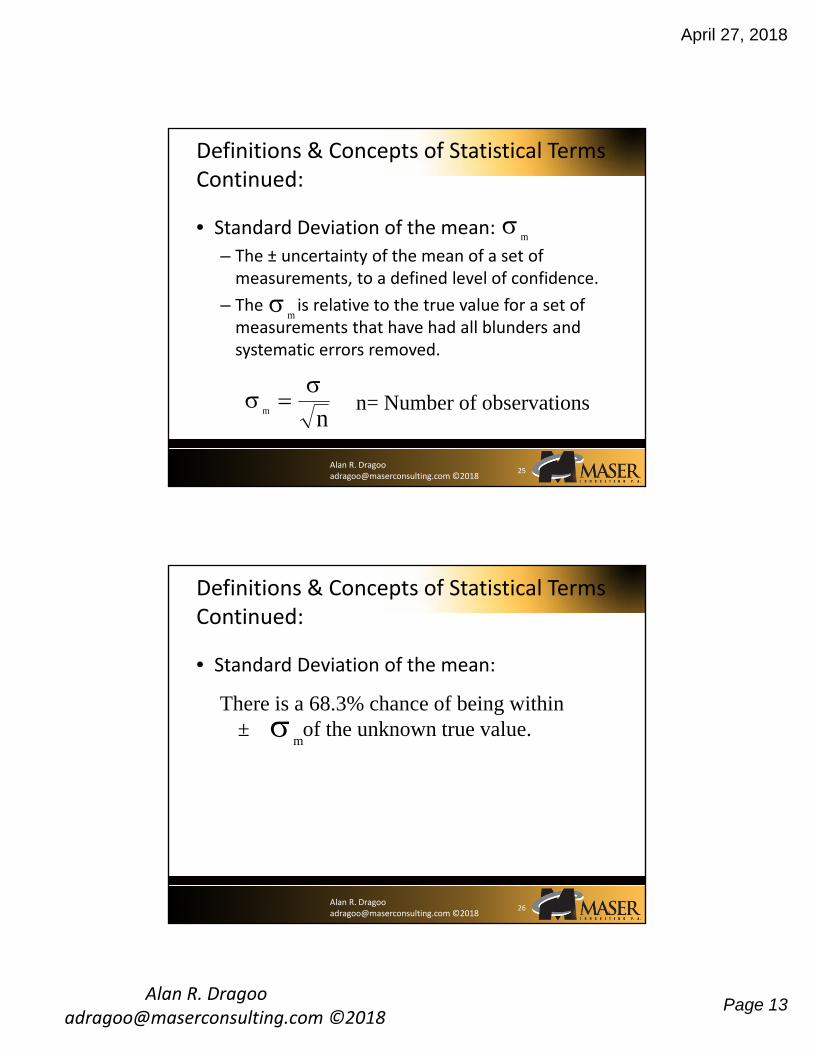
• Standard Deviation of the mean:
– The ± uncertainty of the mean of a set of measurements, to a defined level of confidence.
– The is relative to the true value for a set of measurements that have had all blunders and systematic errors removed.
Definitions & Concepts of Statistical Terms Continued:
m
m
m n n= Number of observations
25
Alan R. Dragoo [email protected] ©2018
• Standard Deviation of the mean:
Definitions & Concepts of Statistical Terms Continued:
There is a 68.3% chance of being within ± of the unknown true value.
m
26

April 27, 2018
Alan R. Dragoo [email protected] ©2018
Page 14
Alan R. Dragoo [email protected] ©2018
• Standard Deviation with various levels of confidence.
Definitions & Concepts of Statistical Terms Continued:
3 32 2
27
Alan R. Dragoo [email protected] ©2018
• Levels of confidence:
Definitions & Concepts of Statistical Terms Continued:
28
(Note: Actually, the 95% error is closer to 1.96 , but 2 is often accepted as a convenient conversion.)
Name of error Value % CertaintyProbable or CEP 0.6745 50%Standard Deviation 1 68.390% Error 1.6449 90%Two Sigma or 95% Error 2 95%99% Error 2.5 99%Three Sigma 3 99.70%

April 27, 2018
Alan R. Dragoo [email protected] ©2018
Page 15
Alan R. Dragoo [email protected] ©2018
Confidence & Standard Error Relationships
• If you want more certainty that your measurements don’t fall outside of your tolerance level, inflate the confidence level
• Doubling the certainty level will double the standard error
• To decrease the standard error, increase the accuracy or redundancy
29
Alan R. Dragoo [email protected] ©2018
• Statistics for real world measurements:
– All contributions to the total error must be considered.
– Mathematically errors accumulate in the following format.
Definitions & Concepts of Statistical Terms Continued:
30
T x x xn 1
2
2
2 2
= Total Standard Error
= Standard Error for each error source
Tx

April 27, 2018
Alan R. Dragoo [email protected] ©2018
Page 16
Alan R. Dragoo [email protected] ©2018
Summary of Unadjusted Input Observations========================================
Number of Measured Angle Observations (DMS) = 5At From To Angle StdErr t-T302 301 303 182-02-24.50 9.10 0.01302 301 1001 82-24-04.00 8.51 -0.00303 302 304 347-59-39.25 4.24 0.00304 303 305 83-02-34.25 10.97 -0.00303 302 306 103-41-50.00 25.67 0.00
Number of Measured Distance Observations (FeetUS) = 5From To Distance StdErr HI HT Comb Grid Type302 303 384.2394 0.0091 5.730 5.320 0.9999556 S302 1001 254.0649 0.0090 5.730 5.000 0.9999554 S303 304 407.5322 0.0092 5.320 5.560 0.9999556 S304 305 140.2624 0.0088 5.560 5.900 0.9999554 S303 306 58.7463 0.0088 5.480 5.000 0.9999560 S
Number of Zenith Observations (DMS) = 5
From To Zenith StdErr HI HT302 303 91-30-57.25 9.09 5.730 5.320302 1001 90-08-48.75 12.52 5.730 5.000303 304 88-34-52.75 8.73 5.320 5.560304 305 90-36-06.75 21.39 5.560 5.900303 306 93-00-38.00 49.86 5.480 5.000
Star*Net Unadjusted Input Observations
31
Std Errors
Std Errors
Std ErrorsStd Errors
Alan R. Dragoo [email protected] ©2018
• Example EDM error sources simplified
– Instrument centering 0.005 ft
– Target centering 0.005 ft
– EDM system constant 0.016 ft (0.005mm)
– EDM scale error 5ppm
– EDM temp & press error 6ppm
Definitions & Concepts of Statistical Terms Continued:
32
0 005 0 005 0 016 0 0172 2 2. . . . ft
5 6 7 82 2 ppm ppm.
April 27, 2018
Alan R. Dragoo [email protected] ©2018
Page 17
Alan R. Dragoo [email protected] ©2018
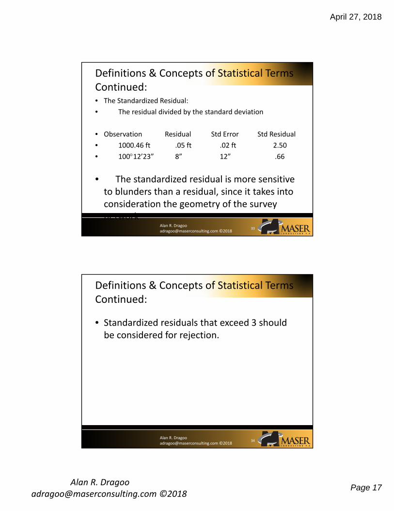
• The Standardized Residual:
• The residual divided by the standard deviation
• Observation Residual Std Error Std Residual
• 1000.46 ft .05 ft .02 ft 2.50
• 10012’23” 8” 12” .66
• The standardized residual is more sensitive to blunders than a residual, since it takes into consideration the geometry of the survey network
Definitions & Concepts of Statistical Terms Continued:
33
Alan R. Dragoo [email protected] ©2018
• Standardized residuals that exceed 3 should be considered for rejection.
Definitions & Concepts of Statistical Terms Continued:
34
April 27, 2018
Alan R. Dragoo [email protected] ©2018
Page 18
Alan R. Dragoo [email protected] ©2018
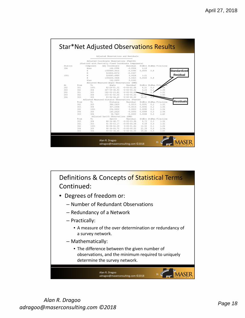
Adjusted Observations and Residuals===================================
Adjusted Coordinate Observations (FeetUS)(Stations with Partially Fixed Coordinate Components)
Station Component Adj Coordinate Residual StdErr StdRes File:Line304 Elev 162.0998 -0.0936 1:19
E 1355489.3610 -0.0390 0.0500 0.8 N 524404.8372 -0.0307
1001 N 524583.4989 0.0628 1:21 E 1355204.3408 0.0423 0.0500 0.8 Elev 162.0609 0.0343 Adjusted Measured Angle Observations (DMS)
At From To Angle Residual StdErr StdRes File:Line302 301 1001 82-24-01.32 -0-00-02.68 8.51 0.3 1:34 303 302 304 347-59-38.93 -0-00-00.32 4.24 0.1 1:36 302 301 303 182-02-23.82 -0-00-00.68 9.10 0.1 1:32 303 302 306 103-41-50.00 0-00-00.00 25.67 0.0 1:40 304 303 305 83-02-34.25 -0-00-00.00 10.97 0.0 1:38
Adjusted Measured Distance Observations (FeetUS)From To Distance Residual StdErr StdRes File:Line302 303 384.2409 0.0015 0.0091 0.2 1:32 303 304 407.5308 -0.0014 0.0092 0.2 1:36 302 1001 254.0652 0.0003 0.0090 0.0 1:34 304 305 140.2624 -0.0000 0.0088 0.0 1:38 303 306 58.7463 -0.0000 0.0088 0.0 1:40
Adjusted Zenith Observations (DMS)From To Zenith Residual StdErr StdRes File:Line303 304 88-34-48.77 -0-00-03.98 8.73 0.5 1:36 302 303 91-30-53.17 -0-00-04.08 9.09 0.4 1:32 302 1001 90-08-50.59 0-00-01.84 12.52 0.1 1:34 304 305 90-36-06.75 -0-00-00.00 21.39 0.0 1:38 303 306 93-00-38.00 -0-00-00.00 49.86 0.0 1:40
Star*Net Adjusted Observations Results
35
Residuals
Standardized
Residual
Alan R. Dragoo [email protected] ©2018
• Degrees of freedom or:
– Number of Redundant Observations
– Redundancy of a Network
– Practically:
• A measure of the over determination or redundancy of a survey network.
– Mathematically:
• The difference between the given number of observations, and the minimum required to uniquely determine the survey network.
Definitions & Concepts of Statistical Terms Continued:
36
April 27, 2018
Alan R. Dragoo [email protected] ©2018
Page 19
Alan R. Dragoo [email protected] ©2018
• Also known as:
• Reference Factoror Variance of unit weight
Total Error Factor:
37
The relationship between the observation errors and the predicted error.
When they are the same the
When the observation errors are less
When the observation errors are more
1
1
1
Alan R. Dragoo [email protected] ©2018
Chi Square Test:
Tests the total error factor to see if it is significantly greater than 1.0 or less than 1.0
38
April 27, 2018
Alan R. Dragoo [email protected] ©2018
Page 20
Alan R. Dragoo [email protected] ©2018
Star*Net Statistical Summary
39
Adjustment Statistical Summary
==============================
Iterations = 2Number of Stations = 7Number of Observations = 21Number of Unknowns = 15Number of Redundant Obs = 6
Observation Count Sum Squares Errorof StdRes Factor
Coordinates 6 6.036 1.876Angles 5 0.111 0.278
Distances 5 0.054 0.194Zeniths 5 0.430 0.549
Total 21 6.631 1.051
The Chi-Square Test at 5.00% Level Passed
Lower/Upper Bounds (0.454/1.552)
Alan R. Dragoo [email protected] ©2018
Least Squares (Mathematically):
Is an adjustment where the sum of the weighted squares of the residuals is at a minimum.
40

April 27, 2018
Alan R. Dragoo [email protected] ©2018
Page 21
Alan R. Dragoo [email protected] ©2018
Advantages to Least Squares:
Minimizes the differences between any possible adjustment and the observations.
41
Alan R. Dragoo [email protected] ©2018
• With enough redundancy in a survey network
– The observations with the errors will be the ones adjusted.
– Observations with blunders can be deleted without adverse impact on the network.
Redundancy, the Key to Not Doing Work Over:
42

April 27, 2018
Alan R. Dragoo [email protected] ©2018
Page 22
Alan R. Dragoo [email protected] ©2018
Knowledge of Error Sources:
• EDM
• Angles
• Accessories
• Natural
• GPS Vectors
• Leveling
43
Alan R. Dragoo [email protected] ©2018
EDM Error Sources:
• Nominal accuracy ±0.016 ft (5mm+5 ppm)
• Instrument Centering ±0.005 ft
• Reflector Centering ±0.005 ft
• Temperature & Pressure ±5 ppm
• Instrument Constant ±0.006 (2mm)
• Reflector Constant ±0.006 (2mm)
44

April 27, 2018
Alan R. Dragoo [email protected] ©2018
Page 23
Alan R. Dragoo [email protected] ©2018
Potential Sources of Angle Error:
• Pointing
• Reading 1” – 6” Normal
• Collimation 1” – 30” Normal +
• Parallax 2” – 3” Normal +
• Inclination 1” – 3” Normal +
• Centering Instrument & Targets ????
• Environmental 1” – 3” Normal +
• Tripod Stability 1” – 3” Normal +
2.42)("0.3 DIN
Alan R. Dragoo [email protected] ©2018
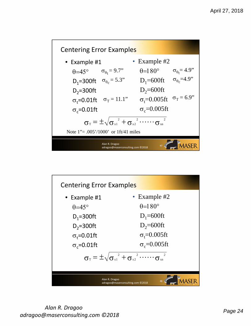
Centering Error Examples
• Example #1
D1=300ft
D2=300ft
t=0.01ft
c=0.01ft
• Example #2
D1=600ft
D2=600ft
t=0.005ft
c=0.005ft
T x x xn 1
2
2
2 2
46
April 27, 2018
Alan R. Dragoo [email protected] ©2018
Page 24
Alan R. Dragoo [email protected] ©2018
Centering Error Examples
• Example #1
D1=300ft
D2=300ft
t=0.01ft
c=0.01ft
• Example #2
D1=600ft
D2=600ft
t=0.005ft
c=0.005ft
T x x xn 1
2
2
2 2
T = 11.1” T = 6.9”
c = 5.3”
t = 9.7” t
= 4.9”
c=4.9”
Note 1”= .005’/1000’ or 1ft/41 miles
47
Alan R. Dragoo [email protected] ©2018
Centering Error Examples
• Example #1
D1=300ft
D2=300ft
t=0.01ft
c=0.01ft
• Example #2
D1=600ft
D2=600ft
t=0.005ft
c=0.005ft
T x x xn 1
2
2
2 2
48

April 27, 2018
Alan R. Dragoo [email protected] ©2018
Page 25
Alan R. Dragoo [email protected] ©2018
Centering Errors:
49
c
D D D D
D D c
1
2
2
2
1 2
1 2
2 cos
t
D D
D D t
1
2
2
2
1 2
Results in Radians
D1
D2
Radians
X 180 = DEC DEG
Alan R. Dragoo [email protected] ©2018
Error Propagation Due To Centering Errors for Instrument and Targets
Accuracy of Measuring Each Angle of a Traverse
Horz Angle 180 Deg
Back Dist D1 = 600.000 Ft
Fwd Dist D2 = 600.000 Ft
Target Centering Error t = 0.010 Ft t = 4.9 "
Inst Centering Error c = 0.010 Ft c = 6.9 "
Number Positons n= 2
Pointing Accuracy p = 2.0 Sec
Reading Accuracy r = 2.0 Sec
Instrment Error p = 1.4 "
Ponting Error r = 1.4 "Dist 5280 Ft = 8.7 "
206265
= 1 / 23,832 =Precision
Trav Dist
Precision = 0.22 Ft Trav Error in Feet
50
April 27, 2018
Alan R. Dragoo [email protected] ©2018
Page 26
Alan R. Dragoo [email protected] ©2018
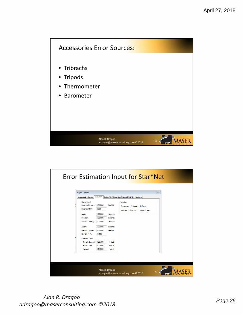
Accessories Error Sources:
• Tribrachs
• Tripods
• Thermometer
• Barometer
51
Alan R. Dragoo [email protected] ©2018
Error Estimation Input for Star*Net
52

April 27, 2018
Alan R. Dragoo [email protected] ©2018
Page 27
Alan R. Dragoo [email protected] ©2018
Network Design:
Add redundancy where possible and practical.
53
Alan R. Dragoo [email protected] ©2018
Network Design for Efficiency & Accuracy
54
Instead of this design with its associated errors:
GPS
Consider this design:
GPS
GPS
GPS
GPS
GPSGPS
GPS
GPS
GPSGPS
GPS
Or This:

April 27, 2018
Alan R. Dragoo [email protected] ©2018
Page 28
Alan R. Dragoo [email protected] ©2018
• #1 Use Procedures That:
– Show the accuracy of your instruments
– Show the accuracy of your measurements
– Use redundancy added to a network to divulge errors and increase confidence.
– Use adjustment techniques that show the accuracy of individual measurements and individual results.
Two Techniques for Not Finding Problems With Survey Measurements
55
Alan R. Dragoo [email protected] ©2018
• #2 Use Procedures
– Where these things are not done so you never see a problem.
• WHICH WAY DO YOU WANT TO GO INTO COURT!
Two Techniques for Not Finding Problems With Survey Measurements
56
April 27, 2018
Alan R. Dragoo [email protected] ©2018
Page 29
Alan R. Dragoo [email protected] ©2018
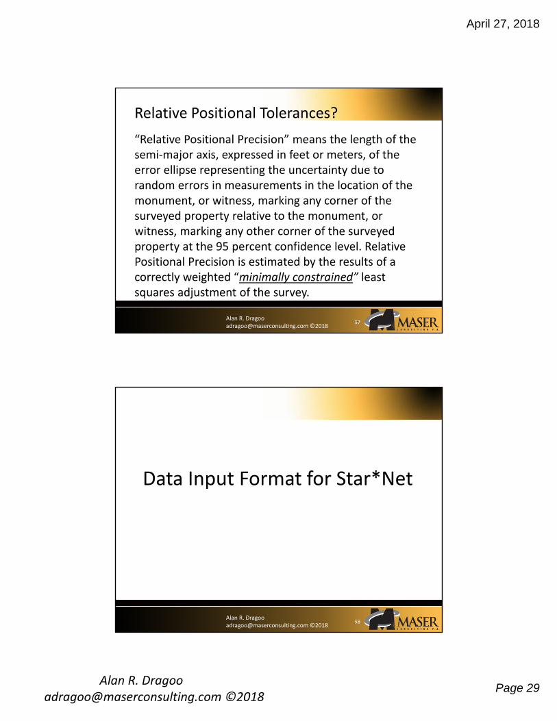
“Relative Positional Precision” means the length of the semi‐major axis, expressed in feet or meters, of the error ellipse representing the uncertainty due to random errors in measurements in the location of the monument, or witness, marking any corner of the surveyed property relative to the monument, or witness, marking any other corner of the surveyed property at the 95 percent confidence level. Relative Positional Precision is estimated by the results of a correctly weighted “minimally constrained” least squares adjustment of the survey.
Relative Positional Tolerances?
57
Alan R. Dragoo [email protected] ©2018
58
Data Input Format for Star*Net

April 27, 2018
Alan R. Dragoo [email protected] ©2018
Page 30
Alan R. Dragoo [email protected] ©2018
Basic Format for 3D Data Entry:
• Special codes:& Defaults to the value defined in Instrument options.
! Observation is FIXED.
* Observation is FREE.
• Coordinates:C Station North East Elev [std. errors]
Examples
C A26C 264874.34 4576845.53 348.43 ! ! !
Or
C 19253 ? ? 385.74 * * !
Items enclosed in square brackets [ ], are optional.
59
Alan R. Dragoo [email protected] ©2018
• Traverse begins:
TB BS station name
Example
TB 19345
TB BS bearing (or azimuth)
Examples
TB N43‐56‐42W
TB 324‐37‐44
Basic Format for 3D Data Entry (Continued):
60
April 27, 2018
Alan R. Dragoo [email protected] ©2018
Page 31
Alan R. Dragoo [email protected] ©2018
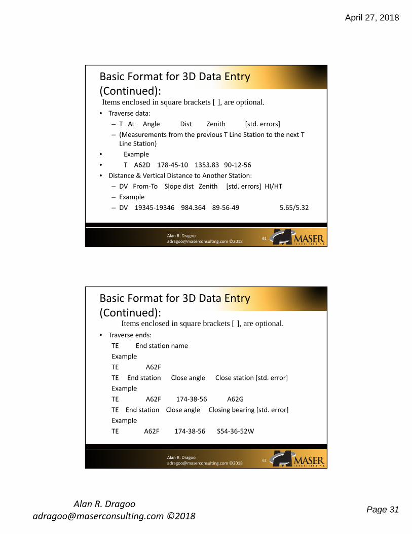
• Traverse data:
– T At Angle Dist Zenith [std. errors]
– (Measurements from the previous T Line Station to the next T Line Station)
• Example
• T A62D 178‐45‐10 1353.83 90‐12‐56
• Distance & Vertical Distance to Another Station:
– DV From‐To Slope dist Zenith [std. errors] HI/HT
– Example
– DV 19345‐19346 984.364 89‐56‐49 5.65/5.32
Basic Format for 3D Data Entry (Continued):
61
Items enclosed in square brackets [ ], are optional.
Alan R. Dragoo [email protected] ©2018
• Traverse ends:
TE End station name
Example
TE A62F
TE End station Close angle Close station [std. error]
Example
TE A62F 174‐38‐56 A62G
TE End station Close angle Closing bearing [std. error]
Example
TE A62F 174‐38‐56 S54‐36‐52W
Basic Format for 3D Data Entry (Continued):
62
Items enclosed in square brackets [ ], are optional.

April 27, 2018
Alan R. Dragoo [email protected] ©2018
Page 32
Alan R. Dragoo [email protected] ©2018
Zenith Angles (3D only):
V from‐to DD‐MM‐SS [std. error]
Bearing or Azimuth:
B from‐to Bearing [std. error]
B from‐to Azimuth [std. error]
Horizontal angles:
A at‐from‐to Angle [std. error]
Basic Format for Other 3D Data Type Entry (Continued):
63
Items enclosed in square brackets [ ], are optional.
Alan R. Dragoo [email protected] ©2018
Distances 3D:
from‐to Slope distance [std. error] HI/HT
Measurements:
M at‐from‐to Angle Distance Zenith [std. error]
Measurement option:
M at‐to‐to ? Distance Zenith HI/HT
Basic Format for Other 3D Data Type Entry (Continued):
64
Items enclosed in square brackets [ ], are optional.
April 27, 2018
Alan R. Dragoo [email protected] ©2018
Page 33
Alan R. Dragoo [email protected] ©2018
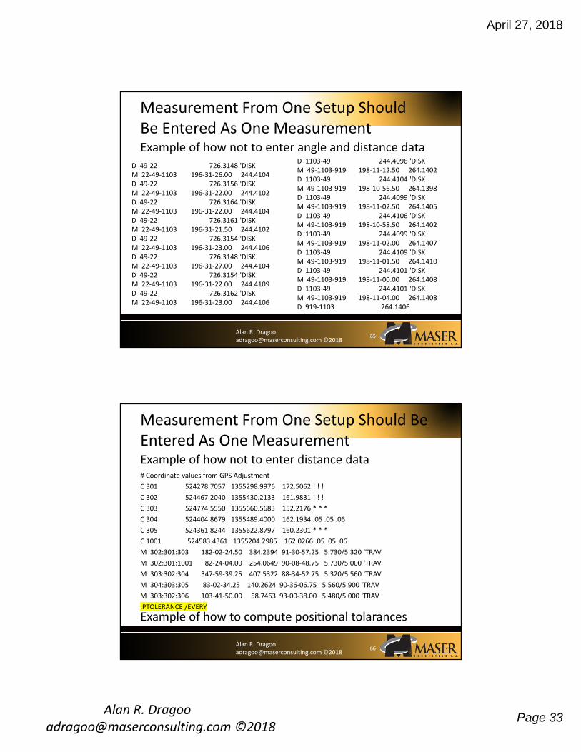
D 49‐22 726.3148 'DISKM 22‐49‐1103 196‐31‐26.00 244.4104D 49‐22 726.3156 'DISKM 22‐49‐1103 196‐31‐22.00 244.4102D 49‐22 726.3164 'DISKM 22‐49‐1103 196‐31‐22.00 244.4104D 49‐22 726.3161 'DISKM 22‐49‐1103 196‐31‐21.50 244.4102D 49‐22 726.3154 'DISKM 22‐49‐1103 196‐31‐23.00 244.4106D 49‐22 726.3148 'DISKM 22‐49‐1103 196‐31‐27.00 244.4104D 49‐22 726.3154 'DISKM 22‐49‐1103 196‐31‐22.00 244.4109D 49‐22 726.3162 'DISKM 22‐49‐1103 196‐31‐23.00 244.4106
Measurement From One Setup Should Be Entered As One Measurement
65
D 1103‐49 244.4096 'DISKM 49‐1103‐919 198‐11‐12.50 264.1402D 1103‐49 244.4104 'DISKM 49‐1103‐919 198‐10‐56.50 264.1398D 1103‐49 244.4099 'DISKM 49‐1103‐919 198‐11‐02.50 264.1405D 1103‐49 244.4106 'DISKM 49‐1103‐919 198‐10‐58.50 264.1402D 1103‐49 244.4099 'DISKM 49‐1103‐919 198‐11‐02.00 264.1407D 1103‐49 244.4109 'DISKM 49‐1103‐919 198‐11‐01.50 264.1410D 1103‐49 244.4101 'DISKM 49‐1103‐919 198‐11‐00.00 264.1408D 1103‐49 244.4101 'DISKM 49‐1103‐919 198‐11‐04.00 264.1408D 919‐1103 264.1406
Example of how not to enter angle and distance data
Alan R. Dragoo [email protected] ©2018
# Coordinate values from GPS Adjustment
C 301 524278.7057 1355298.9976 172.5062 ! ! !
C 302 524467.2040 1355430.2133 161.9831 ! ! !
C 303 524774.5550 1355660.5683 152.2176 * * *
C 304 524404.8679 1355489.4000 162.1934 .05 .05 .06
C 305 524361.8244 1355622.8797 160.2301 * * *
C 1001 524583.4361 1355204.2985 162.0266 .05 .05 .06
M 302:301:303 182‐02‐24.50 384.2394 91‐30‐57.25 5.730/5.320 'TRAV
M 302:301:1001 82‐24‐04.00 254.0649 90‐08‐48.75 5.730/5.000 'TRAV
M 303:302:304 347‐59‐39.25 407.5322 88‐34‐52.75 5.320/5.560 'TRAV
M 304:303:305 83‐02‐34.25 140.2624 90‐36‐06.75 5.560/5.900 'TRAV
M 303:302:306 103‐41‐50.00 58.7463 93‐00‐38.00 5.480/5.000 'TRAV
.PTOLERANCE /EVERY
Measurement From One Setup Should Be Entered As One Measurement
66
Example of how not to enter distance data
Example of how to compute positional tolarances
April 27, 2018
Alan R. Dragoo [email protected] ©2018
Page 34
Alan R. Dragoo [email protected] ©2018
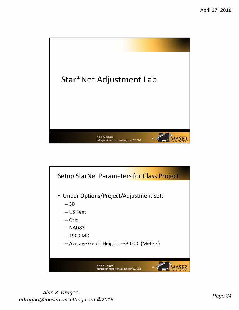
Star*Net Adjustment Lab
67
Alan R. Dragoo [email protected] ©2018
Setup StarNet Parameters for Class Project
• Under Options/Project/Adjustment set:
– 3D
– US Feet
– Grid
– NAD83
– 1900 MD
– Average Geoid Height: ‐33.000 (Meters)
68
April 27, 2018
Alan R. Dragoo [email protected] ©2018
Page 35
Alan R. Dragoo [email protected] ©2018
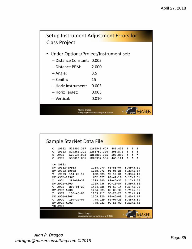
• Under Options/Project/Instrument set:
– Distance Constant: 0.005
– Distance PPM: 2.000
– Angle: 3.5
– Zenith: 15
– Horiz Instrument: 0.005
– Horiz Target: 0.005
– Vertical: 0.010
Setup Instrument Adjustment Errors for Class Project
69
Alan R. Dragoo [email protected] ©2018
Sample StarNet Data FileC 19962 526394.367 1266548.609 481.426 ! ! !C 19963 527366.301 1265750.290 505.576 ! ! !C A90E 528635.003 1265883.165 508.892 ! ! *C A90H 530816.855 1268337.586 465.164 ! ! !
TB 19962 DV 19962-19963 1258.070 88-55-04 5.69/5.31DV 19963-19962 1258.072 91-05-26 5.33/5.67T 19963 154-20-17 652.523 90-18-01 5.33/5.18DV A90D-19963 652.527 89-42-18 5.17/5.31T A90D 281-09-32 1229.740 89-40-35 5.17/5.56DV A90E-A90D 1229.736 90-19-54 5.59/5.16T A90E 203-01-20 1464.825 91-57-14 5.57/5.70DV A90F-A90E 1464.823 88-03-38 5.71/5.55T A90F 153-40-06 1109.217 90-20-20 5.71/5.44DV A90G-A90F 1109.220 89-40-08 5.45/5.69T A90G 197-24-04 778.029 89-04-29 5.45/5.50DV A90H-A90G 778.031 90-56-02 5.52/5.43TE A90H
70

April 27, 2018
Alan R. Dragoo [email protected] ©2018
Page 36
Alan R. Dragoo [email protected] ©2018
Data Entry For Project: PT33‐028
C 19533 516947.596 1325887.115 458.154 ! ! !C 19701 516845.656 1326377.926 459.837 ! ! !
TB 19533DV 19701-19533 501.311 90-05-55 5.45/5.76T 19701 88-40-34 320.298 88-29-34 5.45/5.97DV F07G-19701 320.262 91-17-21 5.37/6.02T F07G 207-14-38 401.564 92-54-27 5.37/6.09DV F07H-F07G 401.623 86-55-31 5.50/5.97T F07H 262-59-06 408.339 87-30-06 5.50/5.93DV F07J-F07H 408.287 92-19-50 5.33/6.09T F07J 140-37-46 1111.589 92-34-32 5.33/5.94DV F07K-F07J 1111.641 87-21-40 5.36/5.93T F07K 323-40-14 333.812 90-28-53 5.36/6.15DV 19886-F07K 333.815 89-18-33 5.56/5.94T 19886 164-30-42 1384.282 89-36-23 5.56/6.09TE 19887
C 19887 515997.322 1327212.805 418.303 ! ! !C 19886 517202.288 1327893.496 409.326 ! ! !C F07H ? ? 446.100 * * !C F07J ? ? 463.500 * * !
71
Alan R. Dragoo [email protected] ©2018
• Under Output/Errors Inspect error file
• Check for incorrect station names
– (F07G is not the same as FO7G)
Trouble Shooting Adjustments That Don’t Run
72
April 27, 2018
Alan R. Dragoo [email protected] ©2018
Page 37
Alan R. Dragoo [email protected] ©2018
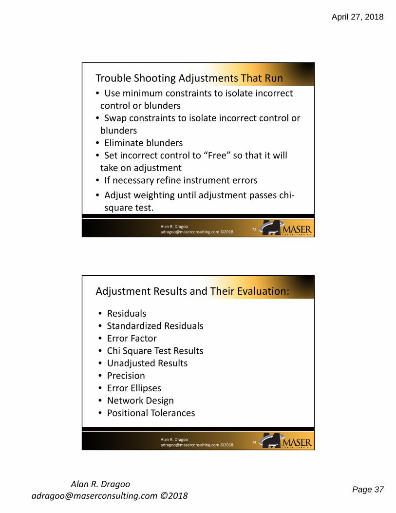
Trouble Shooting Adjustments That Run
• Use minimum constraints to isolate incorrect control or blunders
• Swap constraints to isolate incorrect control or blunders
• Eliminate blunders• Set incorrect control to “Free” so that it will take on adjustment
• If necessary refine instrument errors
• Adjust weighting until adjustment passes chi‐square test.
73
Alan R. Dragoo [email protected] ©2018
Adjustment Results and Their Evaluation:
• Residuals• Standardized Residuals• Error Factor• Chi Square Test Results• Unadjusted Results• Precision• Error Ellipses• Network Design• Positional Tolerances
74
American Land Title Association® (ALTA®) Minimum Standard Detail Requirements National Society of Professional Surveyors (NSPS) For ALTA/NSPS Land Title Surveys
Page 1 of 11
Copyright 2016. All rights reserved. American Land Title Association and National Society of Professional Surveyors
MINIMUM STANDARD DETAIL REQUIREMENTS FOR ALTA/NSPS LAND TITLE SURVEYS
(Effective February 23, 2016)
NOTE - Attention is directed to the fact that the National Society of Professional Surveyors, Inc. (NSPS) is the legal successor organization to the American Congress on Surveying and Mapping (ACSM) and that these 2016 Minimum Standard Detail Requirements for ALTA/NSPS Land Title Surveys are the next version of the former Minimum Standard Detail Requirements for ALTA/ACSM Land Title Surveys.
1. Purpose - Members of the American Land Title Association® (ALTA®) have specific needs, unique to title insurance matters, when asked to insure title to land without exception as to the many matters which might be discoverable from survey and inspection, and which are not evidenced by the public records. For a survey of real property, and the plat, map or record of such survey, to be acceptable to a title insurance company for the purpose of insuring title to said real property free and clear of survey matters (except those matters disclosed by the survey and indicated on the plat or map), certain specific and pertinent information must be presented for the distinct and clear understanding between the insured, the client (if different from the insured), the title insurance company (insurer), the lender, and the surveyor professionally responsible for the survey. In order to meet such needs, clients, insurers, insureds, and lenders are entitled to rely on surveyors to conduct surveys and prepare associated plats or maps that are of a professional quality and appropriately uniform, complete, and accurate. To that end, and in the interests of the general public, the surveying profession, title insurers, and abstracters, the ALTA and the NSPS jointly promulgate the within details and criteria setting forth a minimum standard of performance for ALTA/NSPS Land Title Surveys. A complete 2016 ALTA/NSPS Land Title Survey includes:
(i) the on-site fieldwork required pursuant to Section 5, (ii) the preparation of a plat or map pursuant to Section 6 showing the results of the fieldwork
and its relationship to documents provided to or obtained by the surveyor pursuant to Section 4,
(iii) any information from Table A items requested by the client, and (iv) the certification outlined in Section 7.
2. Request for Survey - The client shall request the survey, or arrange for the survey to be requested, and shall provide a written authorization to proceed from the person or entity responsible for paying for the survey. Unless specifically authorized in writing by the insurer, the insurer shall not be responsible for any costs associated with the preparation of the survey. The request shall specify that an "ALTA/NSPS LAND TITLE SURVEY" is required and which of the optional items listed in Table A, if any, are to be incorporated. Certain properties or interests in real properties may present issues outside those normally encountered on an ALTA/NSPS Land Title Survey (e.g., marinas, campgrounds, trailer parks; easements, leases, other non-fee simple interests). The scope of work related to surveys of such properties or interests in real properties should be discussed with the client, lender, and insurer; and agreed upon in writing prior to commencing work on the survey. The client may need to secure permission for the surveyor to enter upon the property to be surveyed, adjoining properties, or offsite easements.
American Land Title Association® (ALTA®) Minimum Standard Detail Requirements National Society of Professional Surveyors (NSPS) For ALTA/NSPS Land Title Surveys
Page 2 of 11
Copyright 2016. All rights reserved. American Land Title Association and National Society of Professional Surveyors
3. Surveying Standards and Standards of Care A. Effective Date - The 2016 Minimum Standard Detail Requirements for ALTA/NSPS Land Title
Surveys are effective February 23, 2016. As of that date, all previous versions of the Minimum Standard Detail Requirements for ALTA/ACSM Land Title Surveys are superseded by these standards.
B. Other Requirements and Standards of Practice - Many states and some local jurisdictions have adopted statutes, administrative rules, and/or ordinances that set out standards regulating the practice of surveying within their jurisdictions. In addition to the standards set forth herein, surveyors shall also conduct their surveys in accordance with applicable jurisdictional survey requirements and standards of practice. Where conflicts between the standards set forth herein and any such jurisdictional requirements and standards of practice occur, the more stringent shall apply.
C. The Normal Standard of Care - Surveyors should recognize that there may be unwritten local, state, and/or regional standards of care defined by the practice of the “prudent surveyor” in those locales.
D. Boundary Resolution - The boundary lines and corners of any property being surveyed as part of an ALTA/NSPS Land Title Survey shall be established and/or retraced in accordance with appropriate boundary law principles governed by the set of facts and evidence found in the course of performing the research and fieldwork.
E. Measurement Standards - The following measurement standards address Relative Positional Precision for the monuments or witnesses marking the corners of the surveyed property. i. “Relative Positional Precision” means the length of the semi-major axis, expressed in feet or
meters, of the error ellipse representing the uncertainty due to random errors in measurements in the location of the monument, or witness, marking any corner of the surveyed property relative to the monument, or witness, marking any other corner of the surveyed property at the 95 percent confidence level. Relative Positional Precision is estimated by the results of a correctly weighted least squares adjustment of the survey.
ii. Any boundary lines and corners established or retraced may have uncertainties in location resulting from (1) the availability, condition, history and integrity of reference or controlling monuments, (2) ambiguities in the record descriptions or plats of the surveyed property or its adjoiners, (3) occupation or possession lines as they may differ from the written title lines, or (4) Relative Positional Precision. Of these four sources of uncertainty, only Relative Positional Precision is controllable, although, due to the inherent errors in any measurement, it cannot be eliminated. The magnitude of the first three uncertainties can be projected based on evidence; Relative Positional Precision is estimated using statistical means (see Section 3.E.i. above and Section 3.E.v. below).
iii. The first three of these sources of uncertainty must be weighed as part of the evidence in the determination of where, in the surveyor’s opinion, the boundary lines and corners of the surveyed property should be located (see Section 3.D. above). Relative Positional Precision is a measure of how precisely the surveyor is able to monument and report those positions; it is not a substitute for the application of proper boundary law principles. A boundary corner or line may have a small Relative Positional Precision because the survey measurements were precise, yet still be in the wrong position (i.e., inaccurate) if it was established or retraced using faulty or improper application of boundary law principles.
iv. For any measurement technology or procedure used on an ALTA/NSPS Land Title Survey, the surveyor shall (1) use appropriately trained personnel, (2) compensate for systematic errors, including those associated with instrument calibration, and (3) use appropriate error propagation and measurement design theory (selecting the proper instruments, geometric layouts, and field and computational procedures) to control random errors such that the

American Land Title Association® (ALTA®) Minimum Standard Detail Requirements National Society of Professional Surveyors (NSPS) For ALTA/NSPS Land Title Surveys
Page 3 of 11
Copyright 2016. All rights reserved. American Land Title Association and National Society of Professional Surveyors
maximum allowable Relative Positional Precision outlined in Section 3.E.v. below is not exceeded.
v. The maximum allowable Relative Positional Precision for an ALTA/NSPS Land Title Survey is 2 cm (0.07 feet) plus 50 parts per million (based on the direct distance between the two corners being tested). It is recognized that in certain circumstances, the size or configuration of the surveyed property, or the relief, vegetation, or improvements on the surveyed property, will result in survey measurements for which the maximum allowable Relative Positional Precision may be exceeded. If the maximum allowable Relative Positional Precision is exceeded, the surveyor shall note the reason as explained in Section 6.B.x. below.
4. Records Research - It is recognized that for the performance of an ALTA/NSPS Land Title Survey, the surveyor will be provided with appropriate and, when possible, legible data which can be relied upon in the preparation of the survey. The request for an ALTA/NSPS Land Title Survey shall set forth the current record description of the property to be surveyed or, in the case of an original survey prepared for purposes of locating and describing real property that has not been previously separately described in documents conveying an interest in the real property, the current record description of the parent parcel that contains the property to be surveyed. In order to complete an ALTA/NSPS Land Title Survey, the surveyor must be provided with complete copies of the most recent title commitment or, if a title commitment is not available, other title evidence satisfactory to the title insurer. In addition, the surveyor must be provided with the following:
(i) The following records established under state statutes for the purpose of imparting constructive notice of matters relating to real property (public records): (a) The current record descriptions of any adjoiners to the property to be surveyed, except
where such adjoiners are lots in platted, recorded subdivisions; (b) Any recorded easements benefitting the property; (c) Any recorded easements, servitudes, or covenants burdening the property;
(ii) Any unrecorded documents affecting the property being surveyed and containing information to which the survey shall make reference, if desired by the client.
Except, however, if the documents outlined above in (i) and (ii) of this section are not provided to the surveyor or if non-public or quasi-public documents are required to complete the survey, the surveyor shall be required to conduct only that research which is required pursuant to the statutory or administrative requirements of the jurisdiction where the property being surveyed is located and that research (if any) which is negotiated and outlined in the terms of the contract between the surveyor and the client. 5. Fieldwork - The survey shall be performed on the ground (except as otherwise negotiated pursuant to Table A, Item 15 below, if selected by the client). The fieldwork shall include the following, located to what is, in the surveyor’s professional opinion, the appropriate degree of precision based on (a) the planned use of the property, if reported in writing to the surveyor by the client, lender, or insurer, or (b) the existing use, if the planned use is not so reported:
A. Monuments i. The location, size, character, and type of any monuments found during the fieldwork. ii. The location, size, character, and type of any monuments set during the fieldwork, if item 1 of
Table A was selected or if otherwise required by applicable jurisdictional requirements and/or standards of practice.
iii. The location, description, and character of any lines that control the boundaries of the

American Land Title Association® (ALTA®) Minimum Standard Detail Requirements National Society of Professional Surveyors (NSPS) For ALTA/NSPS Land Title Surveys
Page 4 of 11
Copyright 2016. All rights reserved. American Land Title Association and National Society of Professional Surveyors
surveyed property. B. Rights of Way and Access
i. The distance from the appropriate corner or corners of the surveyed property to the nearest right of way line, if the surveyed property does not abut a right of way.
ii. The name of any street, highway, or other public or private way abutting the surveyed property, together with the width of the travelled way and the location of each edge of the travelled way including on divided streets and highways. If the documents provided to or obtained by the surveyor pursuant to Section 4 indicate no access from the surveyed property to the abutting street or highway, the width and location of the travelled way need not be located.
iii. Visible evidence of physical access (e.g., curb cuts, driveways) to any abutting streets, highways, or other public or private ways.
iv. The location and character of vehicular, pedestrian, or other forms of access by other than the apparent occupants of the surveyed property to or across the surveyed property observed in the process of conducting the fieldwork (e.g., driveways, alleys, private roads, railroads, railroad sidings and spurs, sidewalks, footpaths).
v. Without expressing a legal opinion as to ownership or nature, the location and extent of any potentially encroaching driveways, alleys, and other ways of access from adjoining properties onto the surveyed property observed in the process of conducting the fieldwork.
vi. Where documentation of the location of any street, road, or highway right of way abutting, on, or crossing the surveyed property was not disclosed in documents provided to or obtained by the surveyor, or was not otherwise available from the controlling jurisdiction (see Section 6.C.iv. below), the evidence and location of parcel corners on the same side of the street as the surveyed property recovered in the process of conducting the fieldwork which may indicate the location of such right of way lines (e.g., lines of occupation, survey monuments).
vii. Evidence of access to and from waters adjoining the surveyed property observed in the process of conducting the fieldwork (e.g., paths, boat slips, launches, piers, docks).
C. Lines of Possession and Improvements along the Boundaries i. The character and location of evidence of possession or occupation along the perimeter of
the surveyed property, both by the occupants of the surveyed property and by adjoiners, observed in the process of conducting the fieldwork.
ii. Unless physical access is restricted, the character and location of all walls, buildings, fences, and other improvements within five feet of each side of the boundary lines, observed in the process of conducting the fieldwork. Trees, bushes, shrubs, and other natural vegetation need not be located other than as specified in the contract, unless they are deemed by the surveyor to be evidence of possession pursuant to Section 5.C.i.
iii. Without expressing a legal opinion as to the ownership or nature of the potential encroachment, the evidence, location and extent of potentially encroaching structural appurtenances and projections observed in the process of conducting the fieldwork (e.g., fire escapes, bay windows, windows and doors that open out, flue pipes, stoops, eaves, cornices, areaways, steps, trim) by or onto adjoining property, or onto rights of way, easements, or setback lines disclosed in documents provided to or obtained by the surveyor.
D. Buildings The location of buildings on the surveyed property observed in the process of conducting the fieldwork.
E. Easements and Servitudes i. Evidence of any easements or servitudes burdening the surveyed property as disclosed in
the documents provided to or obtained by the surveyor pursuant to Section 4 and observed in the process of conducting the fieldwork.
American Land Title Association® (ALTA®) Minimum Standard Detail Requirements National Society of Professional Surveyors (NSPS) For ALTA/NSPS Land Title Surveys
Page 5 of 11
Copyright 2016. All rights reserved. American Land Title Association and National Society of Professional Surveyors
ii. Evidence of easements, servitudes, or other uses by other than the apparent occupants of the surveyed property not disclosed in the documents provided to or obtained by the surveyor pursuant to Section 4, but observed in the process of conducting the fieldwork if they appear to affect the surveyed property (e.g., roads; drives, sidewalks, paths and other ways of access; utility service lines; water courses; ditches; drains; telephone, fiber optic lines, or electric lines; or water, sewer, oil or gas pipelines on or across the surveyed property and on adjoining properties).
iii. Surface indications of underground easements or servitudes on or across the surveyed property observed in the process of conducting the fieldwork (e.g., utility cuts, vent pipes, filler pipes).
iv. Evidence on or above the surface of the surveyed property observed in the process of conducting the fieldwork, which evidence may indicate utilities located on, over or beneath the surveyed property. Examples of such evidence include pipeline markers, manholes, valves, meters, transformers, pedestals, clean-outs, utility poles, overhead lines and guy wires.
F. Cemeteries As accurately as the evidence permits, the perimeter of cemeteries and burial grounds, and the location of isolated gravesites not within a cemetery or burial ground, (i) disclosed in the documents provided to or obtained by the surveyor, or (ii) observed in the process of conducting the fieldwork.
G. Water Features i. The location of springs, ponds, lakes, streams, rivers, canals, ditches, marshes, and swamps
on, running through, or outside, but within five feet of the perimeter boundary of, the surveyed property, observed during the process of conducting the fieldwork.
ii. The location of any water feature forming a boundary of the surveyed property. The attribute(s) of the water feature located (e.g., top of bank, edge of water, high water mark) should be congruent with the boundary as described in the record description or, in the case of an original survey, in the new description (see Section 6.B.vi. below).
6. Plat or Map - A plat or map of an ALTA/NSPS Land Title Survey shall show the following information. Where dimensioning is appropriate, dimensions shall be annotated to what is, in the surveyor’s professional opinion, the appropriate degree of precision based on (a) the planned use of the property, if reported in writing to the surveyor by the client, lender, or insurer, or (b) existing use, if the planned use is not so reported.
A. The evidence and locations gathered, and the monuments and lines located during the fieldwork pursuant to Section 5 above, with accompanying notes if deemed necessary by the surveyor or as otherwise required as specified below.
B. Boundary, Descriptions, Dimensions, and Closures i. (a) The current record description of the surveyed property, or
(b) In the case of an original survey, the current record description of the parent tract that contains the surveyed property.
ii. Any new description of the surveyed property that was prepared in conjunction with the survey, including a statement explaining why the new description was prepared. Except in the case of an original survey, preparation of a new description should be avoided unless deemed necessary or appropriate by the surveyor and insurer. Preparation of a new description should also generally be avoided when the record description is a lot or block in a platted, recorded subdivision. Except in the case of an original survey, if a new description is prepared, a note shall be provided stating (a) that the new description describes the same real estate as the record description or, if it does not, (b) how the new description differs from
American Land Title Association® (ALTA®) Minimum Standard Detail Requirements National Society of Professional Surveyors (NSPS) For ALTA/NSPS Land Title Surveys
Page 6 of 11
Copyright 2016. All rights reserved. American Land Title Association and National Society of Professional Surveyors
the record description. iii. The point of beginning, the remote point of beginning or point of commencement (if
applicable) and all distances and directions identified in the record description of the surveyed property (and in the new description, if one was prepared). Where a measured or calculated dimension differs from the record by an amount deemed significant by the surveyor, such dimension shall be shown in addition to, and differentiated from, the corresponding record dimension. All dimensions shown on the survey and contained in any new description shall be ground dimensions unless otherwise noted.
iv. The directional, distance and curve data necessary to compute a mathematical closure of the surveyed boundary. A note if the record description does not mathematically close. The basis of bearings and, where it differs from the record basis, the difference.
v. The remainder of any recorded lot or existing parcel, when the surveyed property is composed of only a portion of such lot or parcel, shall be graphically depicted. Such remainder need not be included as part of the actual survey, except to the extent necessary to locate the lines and corners of the surveyed property, and it need not be fully dimensioned or drawn at the same scale as the surveyed property.
vi. When the surveyed property includes a title line defined by a water boundary, a note on the face of the plat or map noting the date the boundary was measured, which attribute(s) of the water feature was/were located, and the caveat that the boundary is subject to change due to natural causes and that it may or may not represent the actual location of the limit of title. When the surveyor is aware of natural or artificial realignments or changes in such boundaries, the extent of those changes and facts shall be shown or explained.
vii. The relationship of the boundaries of the surveyed property with its adjoiners (e.g., contiguity, gaps, overlaps), where ascertainable from documents provided to or obtained by the surveyor pursuant to Section 4 and/or from field evidence gathered during the process of conducting the fieldwork. If the surveyed property is composed of multiple parcels, the extent of any gaps or overlaps between those parcels shall be identified. Where gaps or overlaps are identified, the surveyor shall, prior to or upon delivery of the final plat or map, disclose this to the insurer and client.
viii. When, in the opinion of the surveyor, the results of the survey differ significantly from the record, or if a fundamental decision related to the boundary resolution is not clearly reflected on the plat or map, the surveyor shall explain this information with notes on the face of the plat or map.
ix. The location of all buildings on the surveyed property, located pursuant to Section 5.D., dimensioned perpendicular to those perimeter boundary lines that the surveyor deems appropriate (i.e., where potentially impacted by a setback line) and/or as requested by the client, lender or insurer.
x. A note on the face of the plat or map explaining the site conditions that resulted in a Relative Positional Precision that exceeds the maximum allowed pursuant to Section 3.E.v.
xi. A note on the face of the plat or map identifying areas, if any, on the boundaries of the surveyed property, to which physical access within five feet was restricted (see Section 5.C.ii.).
xii. A note on the face of the plat or map identifying the source of the title commitment or other title evidence provided pursuant to Section 4, and the effective date and the name of the insurer of same.
C. Easements, Servitudes, Rights of Way, Access, and Documents i. The location, width, and recording information of all plottable rights of way, easements, and
servitudes burdening and benefitting the property surveyed, as evidenced by documents provided to or obtained by the surveyor pursuant to Section 4.

American Land Title Association® (ALTA®) Minimum Standard Detail Requirements National Society of Professional Surveyors (NSPS) For ALTA/NSPS Land Title Surveys
Page 7 of 11
Copyright 2016. All rights reserved. American Land Title Association and National Society of Professional Surveyors
ii. A summary of all rights of way, easements and servitudes burdening the property surveyed and identified in the title evidence provided to or obtained by the surveyor pursuant to Section 4. Such summary shall include the record information of each such right of way, easement or servitude, a statement indicating whether or not it is shown on the plat or map, and a related note if: (a) the location cannot be determined from the record document; (b) there was no observed evidence at the time of the fieldwork; (c) it is a blanket easement; (d) it is not on, or does not touch, the surveyed property; (e) it limits access to an otherwise abutting right of way; (f) the documents are illegible; or (g) the surveyor has information indicating that it may have been released or otherwise
terminated. In cases where the surveyed property is composed of multiple parcels, indicate which of such parcels the various rights of way, easements, and servitudes cross or touch.
iii. A note if no physical access to a public way was observed in the process of conducting the fieldwork.
iv. The locations and widths of rights of way abutting or crossing the surveyed property, and the source of such information, (a) where available from the controlling jurisdiction, or (b) where disclosed in documents provided to or obtained by the surveyor pursuant to Section 4.
v. The identifying titles of all recorded plats, filed maps, right of way maps, or similar documents which the survey represents, wholly or in part, with their recording or filing data.
vi. For non-platted adjoining land, recording data identifying adjoining tracts according to current public records. For platted adjoining land, the recording data of the subdivision plat.
vii. Platted setback or building restriction lines which appear on recorded subdivision plats or which were disclosed in documents provided or obtained by the surveyor.
D. Presentation i. The plat or map shall be drawn on a sheet of not less than 8 ½ by 11 inches in size at a
legible, standard engineering scale, with that scale clearly indicated in words or numbers and with a graphic scale.
ii. The plat or map shall include: (a) The boundary of the surveyed property drawn in a manner that distinguishes it from other
lines on the plat or map. (b) If no buildings were observed on the surveyed property in the process of conducting the
fieldwork, a note stating “No buildings observed.” (c) A north arrow (with north to the top of the drawing when practicable). (d) A legend of symbols and abbreviations. (e) A vicinity map showing the property in reference to nearby highway(s) or major street
intersection(s). (f) Supplementary or detail diagrams when necessary. (g) Notes explaining any modifications to Table A items and the nature of any additional
Table A items (e.g., 21(a), 21(b), 21(c)) that were negotiated between the surveyor and client.
(h) The surveyor’s project number (if any), and the name, registration or license number, signature, seal, street address, telephone number, company website, and email address (if any) of the surveyor who performed the survey.
(i) The date(s) of any revisions made by the surveyor who performed the survey. (j) Sheet numbers where the plat or map is composed of more than one sheet. (k) The caption “ALTA/NSPS Land Title Survey.”
American Land Title Association® (ALTA®) Minimum Standard Detail Requirements National Society of Professional Surveyors (NSPS) For ALTA/NSPS Land Title Surveys
Page 8 of 11
Copyright 2016. All rights reserved. American Land Title Association and National Society of Professional Surveyors
iii. When recordation or filing of a plat or map is required by law, such plat or map shall be produced in recordable form.
7. Certification - The plat or map of an ALTA/NSPS Land Title Survey shall bear only the following certification, unaltered, except as may be required pursuant to Section 3.B. above:
To (name of insured, if known), (name of lender, if known), (name of insurer, if known), (names of others as negotiated with the client):
This is to certify that this map or plat and the survey on which it is based were made in accordance with the 2016 Minimum Standard Detail Requirements for ALTA/NSPS Land Title Surveys, jointly established and adopted by ALTA and NSPS, and includes Items ___________ of Table A thereof. The fieldwork was completed on ___________ [date].
Date of Plat or Map: ___________ (Surveyor’s signature, printed name and seal with
Registration/License Number) 8. Deliverables - The surveyor shall furnish copies of the plat or map of survey to the insurer and client and as otherwise negotiated with the client. Hard copies shall be on durable and dimensionally stable material of a quality standard acceptable to the insurer. A digital image of the plat or map may be provided in addition to, or in lieu of, hard copies pursuant to the terms of the contract. When required by law or requested by the client, the plat or map shall be produced in recordable form and recorded or filed in the appropriate office or with the appropriate agency.

American Land Title Association® (ALTA®) Minimum Standard Detail Requirements National Society of Professional Surveyors (NSPS) For ALTA/NSPS Land Title Surveys
Page 9 of 11
Copyright 2016. All rights reserved. American Land Title Association and National Society of Professional Surveyors
TABLE A
OPTIONAL SURVEY RESPONSIBILITIES AND SPECIFICATIONS NOTE: The twenty (20) items of Table A may be negotiated between the surveyor and client. Any additional items negotiated between the surveyor and client shall be identified as 21(a), 21(b), etc. and explained pursuant to Section 6.D.ii.(g). Notwithstanding Table A Items 5 and 11, if an engineering design survey is desired as part of an ALTA/NSPS Land Title Survey, such services should be negotiated under Table A, Item 21. If checked, the following optional items are to be included in the ALTA/NSPS LAND TITLE SURVEY, except as otherwise qualified (see note above): 1. _____ Monuments placed (or a reference monument or witness to the corner) at all major
corners of the boundary of the property, unless already marked or referenced by existing monuments or witnesses in close proximity to the corner.
2. _____ Address(es) of the surveyed property if disclosed in documents provided to or obtained
by the surveyor, or observed while conducting the fieldwork. 3. _____ Flood zone classification (with proper annotation based on federal Flood Insurance Rate
Maps or the state or local equivalent) depicted by scaled map location and graphic plotting only.
4. _____ Gross land area (and other areas if specified by the client). 5. _____ Vertical relief with the source of information (e.g., ground survey, aerial map), contour
interval, datum, and originating benchmark identified. 6. _____ (a) If set forth in a zoning report or letter provided to the surveyor by the client, list the
current zoning classification, setback requirements, the height and floor space area restrictions, and parking requirements. Identify the date and source of the report or letter.
_____ (b) If the zoning setback requirements are set forth in a zoning report or letter provided to the surveyor by the client, and if those requirements do not require an interpretation by the surveyor, graphically depict the building setback requirements. Identify the date and source of the report or letter.
7. _____ (a) Exterior dimensions of all buildings at ground level. (b) Square footage of: _____ (1) exterior footprint of all buildings at ground level. _____ (2) other areas as specified by the client. _____ (c) Measured height of all buildings above grade at a location specified by the client. If no
location is specified, the point of measurement shall be identified.
American Land Title Association® (ALTA®) Minimum Standard Detail Requirements National Society of Professional Surveyors (NSPS) For ALTA/NSPS Land Title Surveys
Page 10 of 11
Copyright 2016. All rights reserved. American Land Title Association and National Society of Professional Surveyors
8. _____ Substantial features observed in the process of conducting the fieldwork (in addition to
the improvements and features required pursuant to Section 5 above) (e.g., parking lots, billboards, signs, swimming pools, landscaped areas, substantial areas of refuse).
9. _____ Number and type (e.g., disabled, motorcycle, regular and other marked specialized
types) of clearly identifiable parking spaces on surface parking areas, lots and in parking structures. Striping of clearly identifiable parking spaces on surface parking areas and lots.
10. _____ (a) As designated by the client, a determination of the relationship and location of certain
division or party walls with respect to adjoining properties (client to obtain necessary permissions).
_____ (b) As designated by the client, a determination of whether certain walls are plumb (client
to obtain necessary permissions). 11. _____ Location of utilities existing on or serving the surveyed property as determined by:
observed evidence collected pursuant to Section 5.E.iv.
evidence from plans requested by the surveyor and obtained from utility companies, or provided by client (with reference as to the sources of information), and
markings requested by the surveyor pursuant to an 811 utility locate or similar request
Representative examples of such utilities include, but are not limited to:
Manholes, catch basins, valve vaults and other surface indications of subterranean uses;
Wires and cables (including their function, if readily identifiable) crossing the surveyed property, and all poles on or within ten feet of the surveyed property. Without expressing a legal opinion as to the ownership or nature of the potential encroachment, the dimensions of all encroaching utility pole crossmembers or overhangs; and
Utility company installations on the surveyed property. Note to the client, insurer, and lender - With regard to Table A, item 11, source
information from plans and markings will be combined with observed evidence of utilities pursuant to Section 5.E.iv. to develop a view of the underground utilities. However, lacking excavation, the exact location of underground features cannot be accurately, completely, and reliably depicted. In addition, in some jurisdictions, 811 or other similar utility locate requests from surveyors may be ignored or result in an incomplete response, in which case the surveyor shall note on the plat or map how this affected the surveyor’s assessment of the location of the utilities. Where additional or more detailed information is required, the client is advised that excavation and/or a private utility locate request may be necessary.
12. _____ As specified by the client, Governmental Agency survey-related requirements (e.g., HUD
surveys, surveys for leases on Bureau of Land Management managed lands).

American Land Title Association® (ALTA®) Minimum Standard Detail Requirements National Society of Professional Surveyors (NSPS) For ALTA/NSPS Land Title Surveys
Page 11 of 11
Copyright 2016. All rights reserved. American Land Title Association and National Society of Professional Surveyors
13. _____ Names of adjoining owners according to current tax records. If more than one owner, identify the first owner’s name listed in the tax records followed by “et al.”
14. _____ As specified by the client, distance to the nearest intersecting street. 15. _____ Rectified orthophotography, photogrammetric mapping, remote sensing, airborne/mobile
laser scanning and other similar products, tools or technologies as the basis for the showing the location of certain features (excluding boundaries) where ground measurements are not otherwise necessary to locate those features to an appropriate and acceptable accuracy relative to a nearby boundary. The surveyor shall (a) discuss the ramifications of such methodologies (e.g., the potential precision and completeness of the data gathered thereby) with the insurer, lender, and client prior to the performance of the survey, and (b) place a note on the face of the survey explaining the source, date, precision, and other relevant qualifications of any such data.
16. _____ Evidence of recent earth moving work, building construction, or building additions
observed in the process of conducting the fieldwork. 17. _____ Proposed changes in street right of way lines, if such information is made available to the
surveyor by the controlling jurisdiction. Evidence of recent street or sidewalk construction or repairs observed in the process of conducting the fieldwork.
18. _____ If there has been a field delineation of wetlands conducted by a qualified specialist hired
by the client, the surveyor shall locate any delineation markers observed in the process of conducting the fieldwork and show them on the face of the plat or map. If no markers were observed, the surveyor shall so state.
19. _____ Include any plottable offsite (i.e., appurtenant) easements or servitudes disclosed in
documents provided to or obtained by the surveyor as a part of the survey pursuant to Sections 5 and 6 (and applicable selected Table A items) (client to obtain necessary permissions).
20. _____ Professional Liability Insurance policy obtained by the surveyor in the minimum amount
of $____________ to be in effect throughout the contract term. Certificate of Insurance to be furnished upon request, but this item shall not be addressed on the face of the plat or map.
21. _____ ___________________________________________________________________ Adopted by the Board of Governors, American Land Title Association, on October 8, 2015. American Land Title Association, 1800 M St., N.W., Suite 300S, Washington, D.C. 20036-5828. www.alta.org Adopted by the Board of Directors, National Society of Professional Surveyors, on October 9, 2015. National Society of Professional Surveyors, Inc., 5119 Pegasus Court, Suite Q, Frederick, MD 21704. http://www.nsps.us.com/