Embed Size (px)
Citation preview
1INSPIRE Dec 2006 – slide 1
INSPIRE DirectiveINSPIRE Directive–– Infrastructure for Spatial Information in Europe Infrastructure for Spatial Information in Europe --
Status and OutlookStatus and Outlook
European Commission Directorate-General Environment
Research, Science and Innovation Unit
Rue de la Loi, 2001049 Brussels BELGIUM
2INSPIRE Dec 2006 – slide 2
OutlineOutline
• Background – The broader picture– Why INSPIRE?
• INSPIRE Proposal for Directive– Key objectives– Requirements
• INSPIRE Roadmap– Work Programme – Processes and Organisational framework
3INSPIRE Dec 2006 – slide 3
Policies SupportPolicies SupportTo Monitor .. To Implement To Monitor .. To Implement …… To DevelopTo Develop
• Agenda 21, the Rio Declaration on Environment and Development , WSSD Johannesburg 2002
• The Treaty on European Union• The EU Sustainable Development Strategy• The EU 6th Environmental Action Programme
Seven Thematic Strategies1. Clean Air For Europe (CAFE)2. Soil protection3. Sustainable use of pesticides4. Marine environment5. Waste prevention and recycling6. Sustainable use of natural resources7. Urban environment
Four Priorities
1. Climate Change 2. Nature and Biodiversity3. Environment and Health4. Natural resources and waste
• Hyogo Framework for Action 2005-2015: Building the Resilience of Nations and Communities to Disasters
4INSPIRE Dec 2006 – slide 4
Information About Information About ……. ?. ?
5INSPIRE Dec 2006 – slide 5
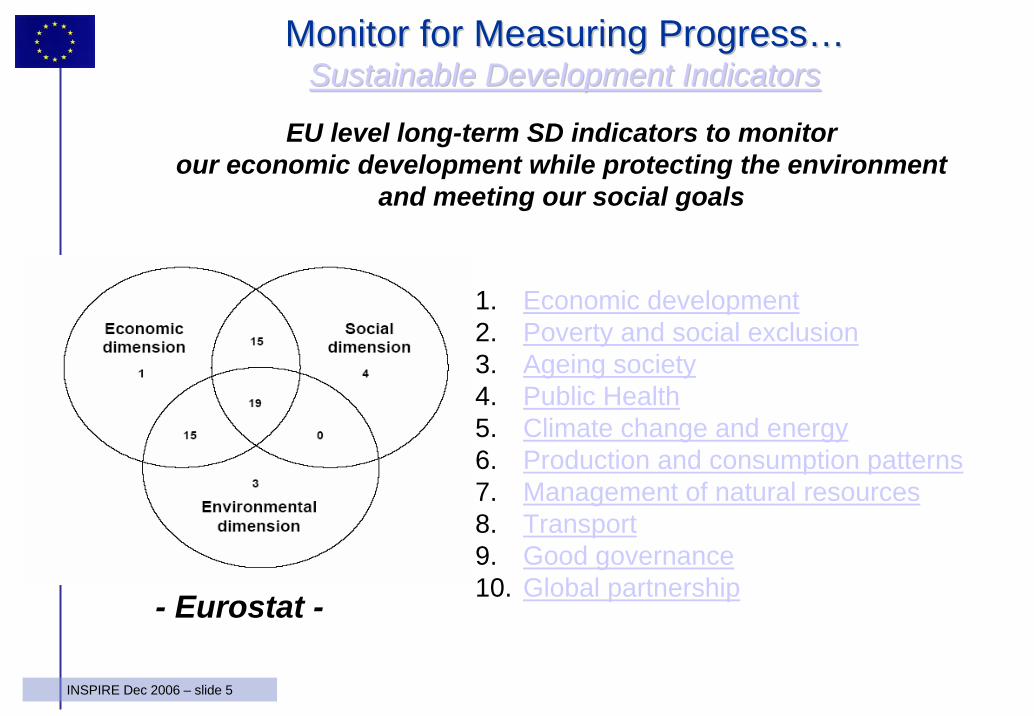
Monitor for Measuring ProgressMonitor for Measuring Progress……Sustainable Development IndicatorsSustainable Development Indicators
1. Economic development2. Poverty and social exclusion3. Ageing society4. Public Health5. Climate change and energy6. Production and consumption patterns7. Management of natural resources8. Transport9. Good governance10. Global partnership
EU level long-term SD indicators to monitorour economic development while protecting the environment
and meeting our social goals
- Eurostat -
6INSPIRE Dec 2006 – slide 6
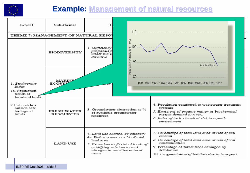
Example: Example: Management of natural resourcesManagement of natural resources
7INSPIRE Dec 2006 – slide 7
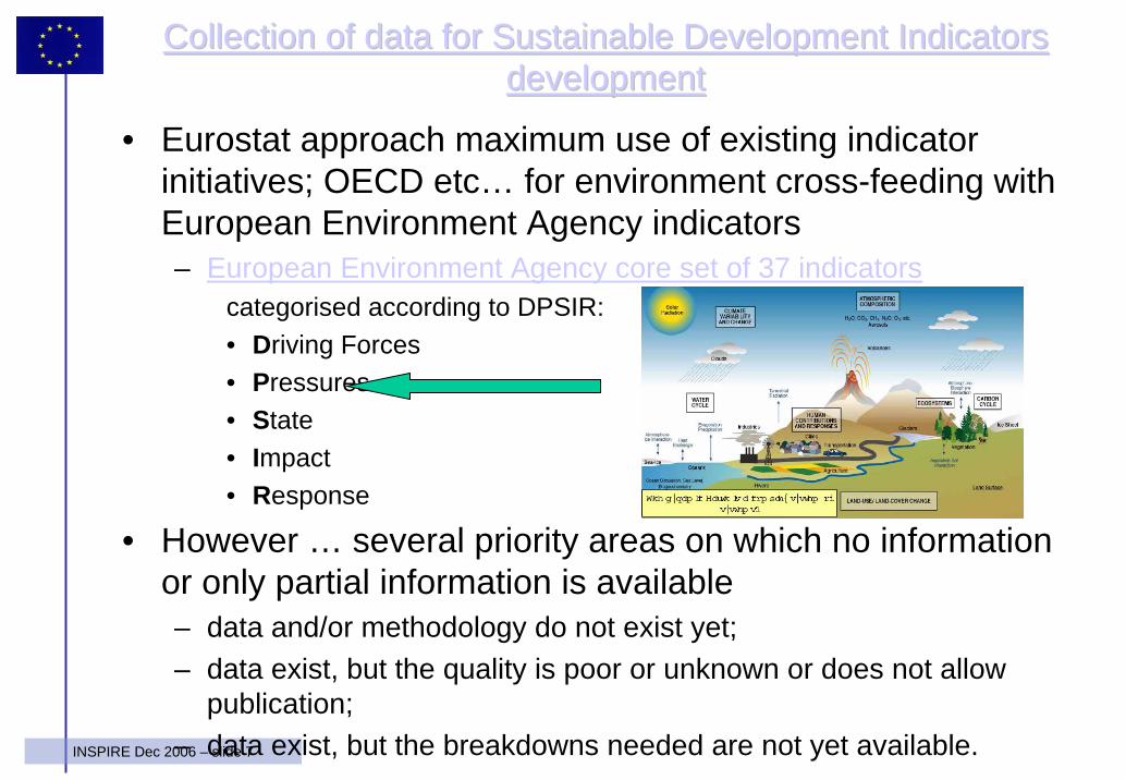
Collection of data for Sustainable Development Indicators Collection of data for Sustainable Development Indicators developmentdevelopment
• Eurostat approach maximum use of existing indicator initiatives; OECD etc… for environment cross-feeding with European Environment Agency indicators– European Environment Agency core set of 37 indicators
categorised according to DPSIR:• Driving Forces• Pressures• State• Impact• Response
• However … several priority areas on which no information or only partial information is available– data and/or methodology do not exist yet;– data exist, but the quality is poor or unknown or does not allow
publication;– data exist, but the breakdowns needed are not yet available.
8INSPIRE Dec 2006 – slide 8
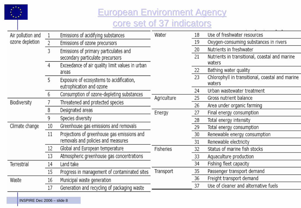
European Environment Agency European Environment Agency core set of 37 indicatorscore set of 37 indicators
9INSPIRE Dec 2006 – slide 9
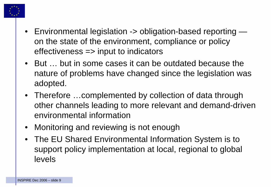
• Environmental legislation -> obligation-based reporting —on the state of the environment, compliance or policy effectiveness => input to indicators
• But … but in some cases it can be outdated because the nature of problems have changed since the legislation was adopted.
• Therefore …complemented by collection of data through other channels leading to more relevant and demand-driven environmental information
• Monitoring and reviewing is not enough • The EU Shared Environmental Information System is to
support policy implementation at local, regional to global levels
10INSPIRE Dec 2006 – slide 10
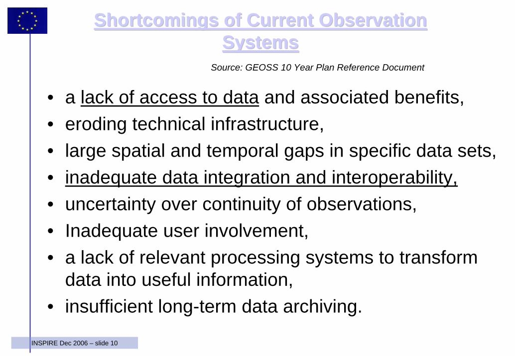
Shortcomings of Current Observation Shortcomings of Current Observation SystemsSystems
• a lack of access to data and associated benefits, • eroding technical infrastructure, • large spatial and temporal gaps in specific data sets, • inadequate data integration and interoperability,• uncertainty over continuity of observations, • Inadequate user involvement, • a lack of relevant processing systems to transform
data into useful information, • insufficient long-term data archiving.
Source: GEOSS 10 Year Plan Reference Document
11INSPIRE Dec 2006 – slide 11
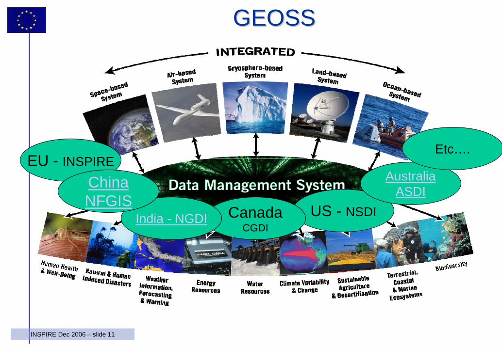
GEOSSGEOSS
EU - INSPIRE
US - NSDICanadaCGDI
India - NGDI
AustraliaASDIChina
NFGIS
Etc….
12INSPIRE Dec 2006 – slide 12
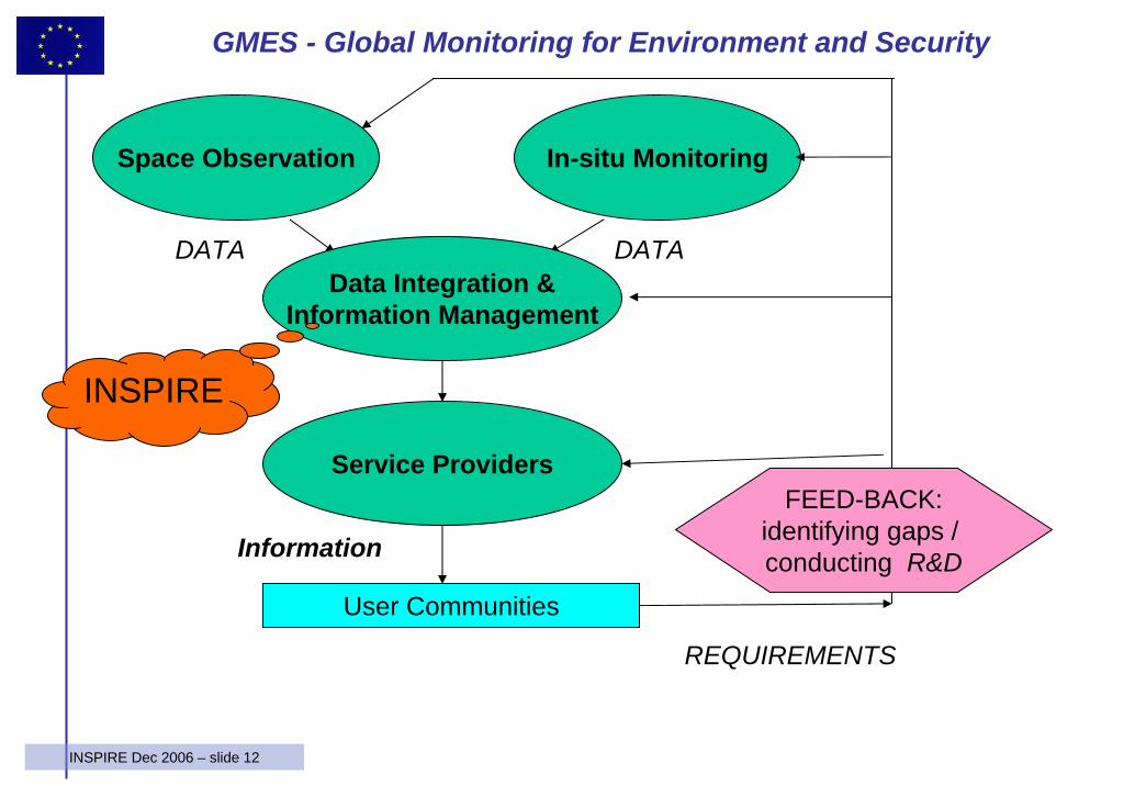
Space Observation In-situ Monitoring
DATA DATA
User Communities
Service Providers
Information
Data Integration &Information Management
FEED-BACK:identifying gaps / conducting R&D
REQUIREMENTS
GMES - Global Monitoring for Environment and Security
INSPIRE
13INSPIRE Dec 2006 – slide 13
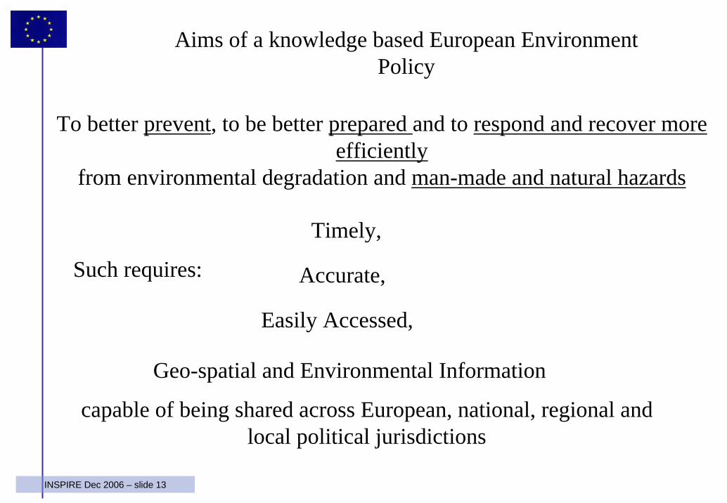
To better prevent, to be better prepared and to respond and recover more efficiently
from environmental degradation and man-made and natural hazards
Timely,
Accurate,
Easily Accessed,
capable of being shared across European, national, regional and local political jurisdictions
Geo-spatial and Environmental Information
Aims of a knowledge based European Environment Policy
Such requires:
14INSPIRE Dec 2006 – slide 14
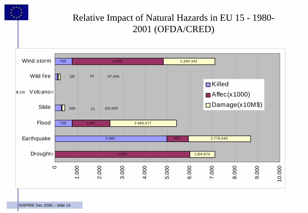
0
4.980
758
0
765
6.000
950
1.687
1.104,670
2.776,640
2.966,577
115
288
4.053
24
7
21
2,284.342
97,600
0,310
120,000
0
1.00
0
2.00
0
3.00
0
4.00
0
5.00
0
6.00
0
7.00
0
8.00
0
9.00
0
10.0
00
Drought
Earthquake
Flood
Slide
Volcano
Wild f ire
Wind storm
KilledAffec(x1000)Damage(x10M$)
Relative Impact of Natural Hazards in EU 15 - 1980-2001 (OFDA/CRED)
15INSPIRE Dec 2006 – slide 15
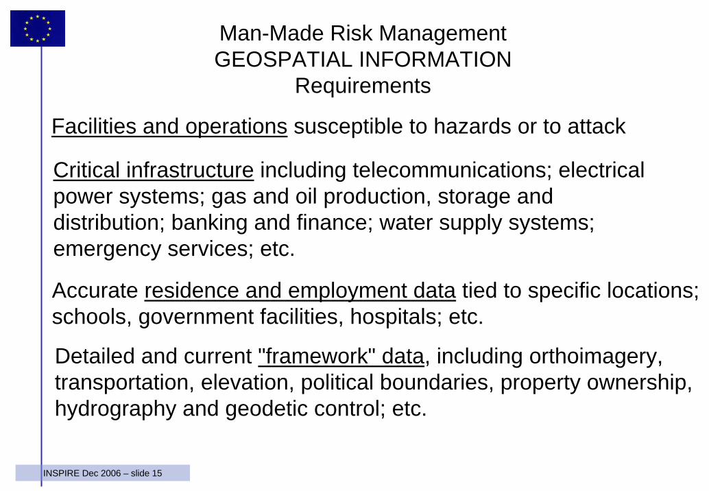
Facilities and operations susceptible to hazards or to attack
Critical infrastructure including telecommunications; electrical power systems; gas and oil production, storage and distribution; banking and finance; water supply systems; emergency services; etc.
Accurate residence and employment data tied to specific locations; schools, government facilities, hospitals; etc.
Detailed and current "framework" data, including orthoimagery, transportation, elevation, political boundaries, property ownership, hydrography and geodetic control; etc.
Man-Made Risk ManagementGEOSPATIAL INFORMATION
Requirements
16INSPIRE Dec 2006 – slide 16
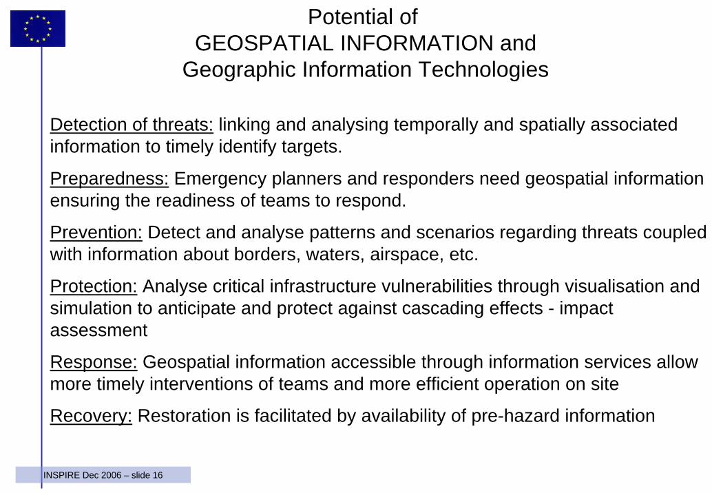
Potential of GEOSPATIAL INFORMATION and
Geographic Information Technologies
Detection of threats: linking and analysing temporally and spatially associated information to timely identify targets.
Preparedness: Emergency planners and responders need geospatial information ensuring the readiness of teams to respond.
Prevention: Detect and analyse patterns and scenarios regarding threats coupled with information about borders, waters, airspace, etc.
Protection: Analyse critical infrastructure vulnerabilities through visualisation and simulation to anticipate and protect against cascading effects - impact assessment
Response: Geospatial information accessible through information services allow more timely interventions of teams and more efficient operation on site
Recovery: Restoration is facilitated by availability of pre-hazard information
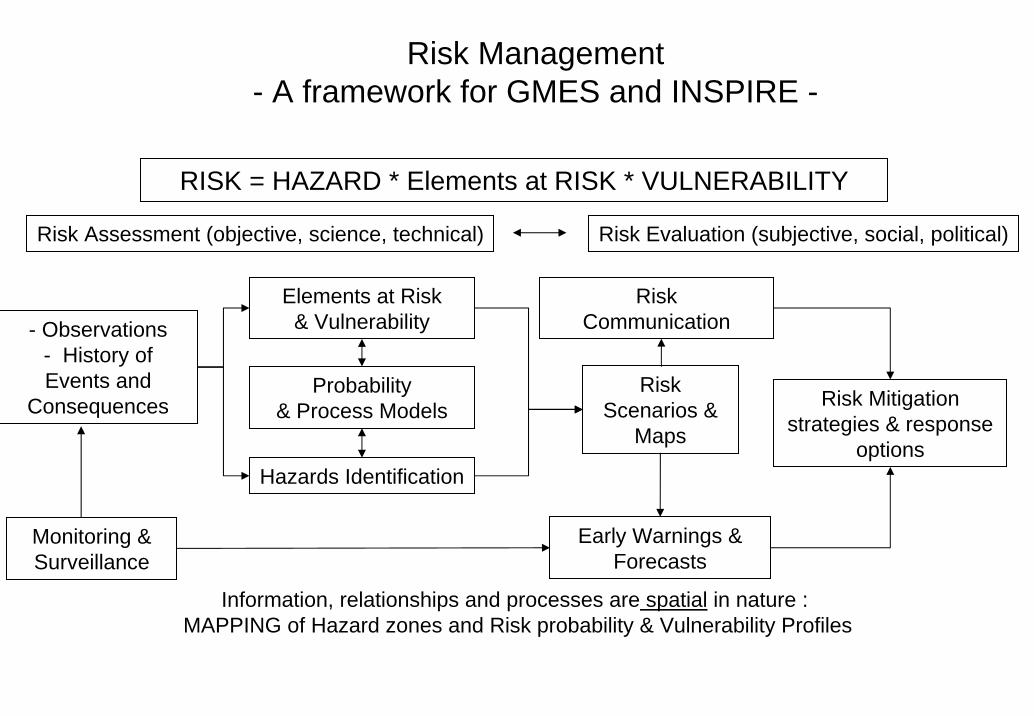
Risk Management- A framework for GMES and INSPIRE -
RISK = HAZARD * Elements at RISK * VULNERABILITY
Information, relationships and processes are spatial in nature : MAPPING of Hazard zones and Risk probability & Vulnerability Profiles
Risk Mitigation strategies & response
options
Elements at Risk & Vulnerability
Hazards Identification
RiskCommunication
Risk Assessment (objective, science, technical) Risk Evaluation (subjective, social, political)
- Observations - History of Events and
Consequences
Monitoring & Surveillance
Early Warnings &Forecasts
Probability & Process Models
Risk Scenarios &
Maps
18INSPIRE Dec 2006 – slide 18
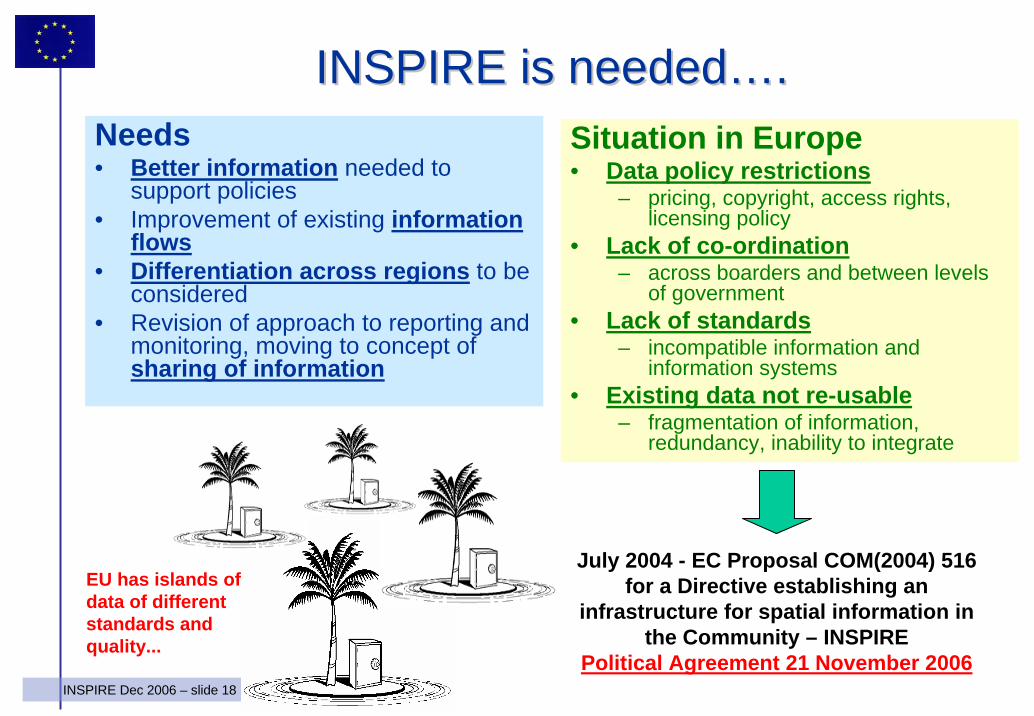
INSPIRE is neededINSPIRE is needed……..Needs• Better information needed to
support policies• Improvement of existing information
flows• Differentiation across regions to be
considered• Revision of approach to reporting and
monitoring, moving to concept of sharing of information
Situation in Europe• Data policy restrictions
– pricing, copyright, access rights, licensing policy
• Lack of co-ordination– across boarders and between levels
of government • Lack of standards
– incompatible information and information systems
• Existing data not re-usable– fragmentation of information,
redundancy, inability to integrate
July 2004 - EC Proposal COM(2004) 516 for a Directive establishing an
infrastructure for spatial information in the Community – INSPIRE
Political Agreement 21 November 2006
EU has islands of data of different standards and quality...
19INSPIRE Dec 2006 – slide 19
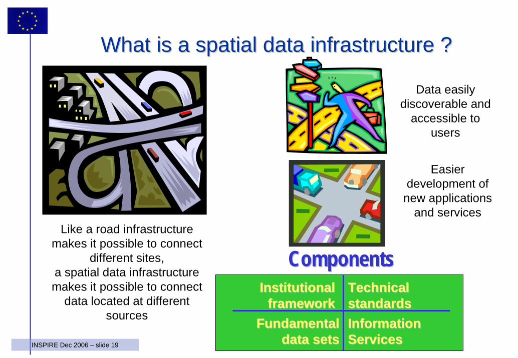
WhatWhat isis a a spatialspatial data data infrastructureinfrastructure ??
Data easilydiscoverable and
accessible tousers
Like a road infrastructuremakes it possible to connect
different sites, a spatial data infrastructuremakes it possible to connect
data located at differentsources
Easierdevelopment of new applications
and services
InstitutionalInstitutionalframeworkframework
Information Information ServicesServices
Fundamental Fundamental data setsdata sets
Technical Technical standardsstandards
ComponentsComponents
20INSPIRE Dec 2006 – slide 20
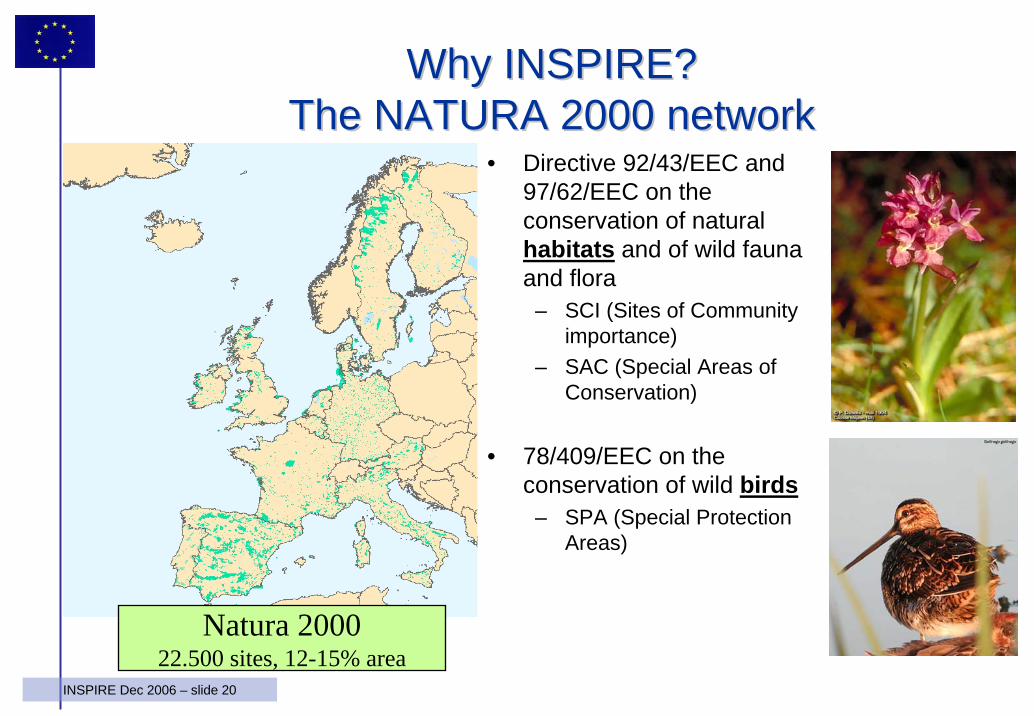
Why INSPIRE? Why INSPIRE? The NATURA 2000 networkThe NATURA 2000 network
• Directive 92/43/EEC and 97/62/EEC on the conservation of natural habitats and of wild fauna and flora
– SCI (Sites of Community importance)
– SAC (Special Areas of Conservation)
• 78/409/EEC on the conservation of wild birds
– SPA (Special Protection Areas)
Natura 200022.500 sites, 12-15% area
21INSPIRE Dec 2006 – slide 21
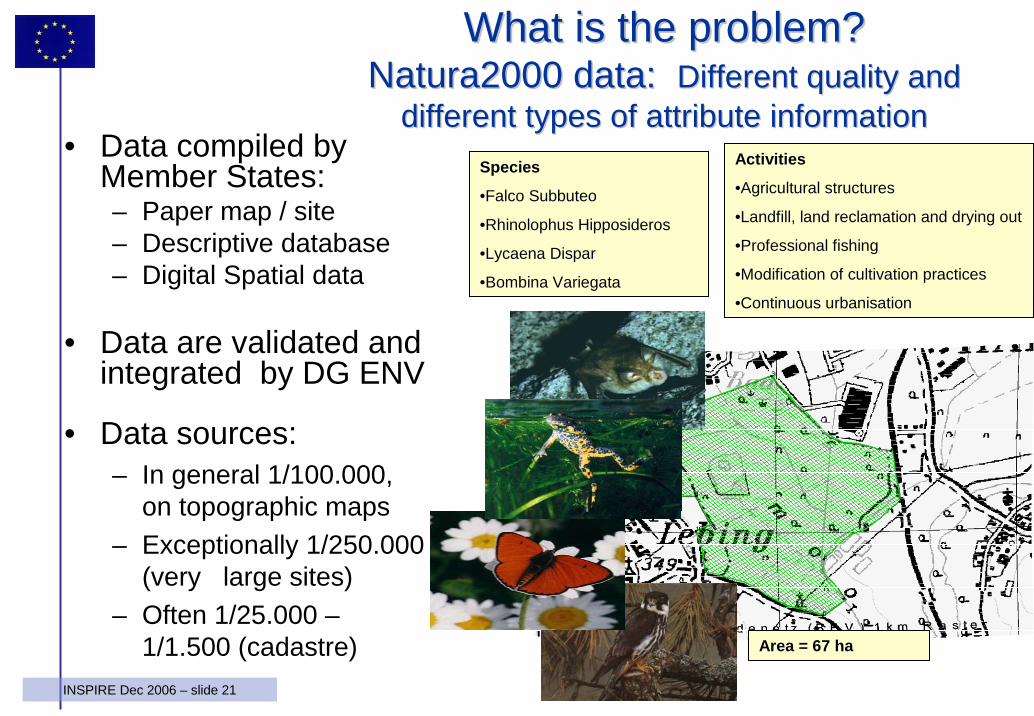
WhatWhat isis the the problemproblem? ? Natura2000 data: Natura2000 data: Different quality and Different quality and
different types of attribute informationdifferent types of attribute information• Data compiled by
Member States:– Paper map / site– Descriptive database– Digital Spatial data
• Data are validated and integrated by DG ENV
• Data sources:– In general 1/100.000,
on topographic maps– Exceptionally 1/250.000
(very large sites)– Often 1/25.000 –
1/1.500 (cadastre)
Activities
•Agricultural structures
•Landfill, land reclamation and drying out
•Professional fishing
•Modification of cultivation practices
•Continuous urbanisation
Area = 67 ha
Species
•Falco Subbuteo
•Rhinolophus Hipposideros
•Lycaena Dispar
•Bombina Variegata
22INSPIRE Dec 2006 – slide 22
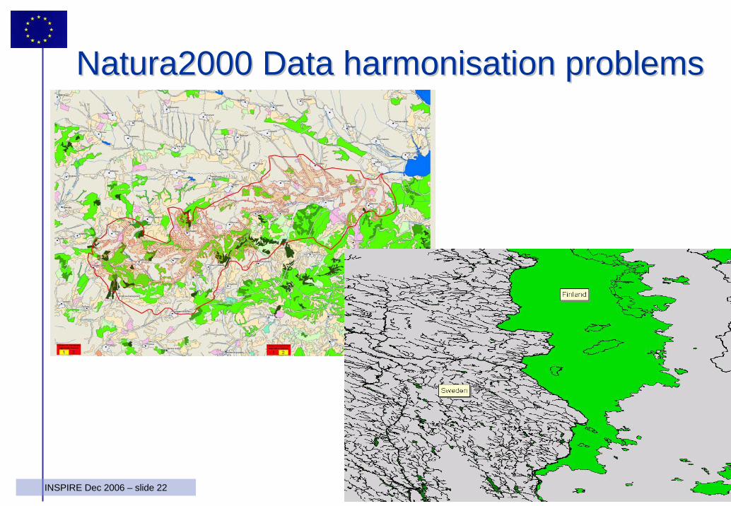
Natura2000 Data Natura2000 Data harmonisationharmonisation problemsproblems
23INSPIRE Dec 2006 – slide 23
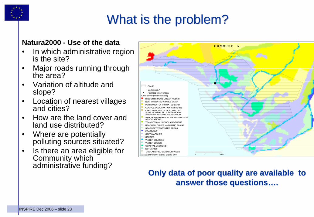
WhatWhat isis the the problemproblem? ? Natura2000 - Use of the data• In which administrative region
is the site?• Major roads running through
the area?• Variation of altitude and
slope?• Location of nearest villages
and cities?• How are the land cover and
land use distributed?• Where are potentially
polluting sources situated?• Is there an area eligible for
Community whichadministrative funding?
Only data of poor quality are available to Only data of poor quality are available to answer those questionsanswer those questions……..
24INSPIRE Dec 2006 – slide 24
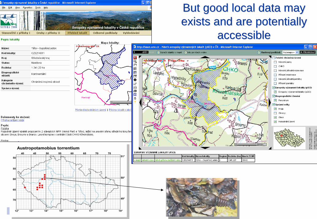
But good local data may But good local data may exists and are potentially exists and are potentially
accessible accessible
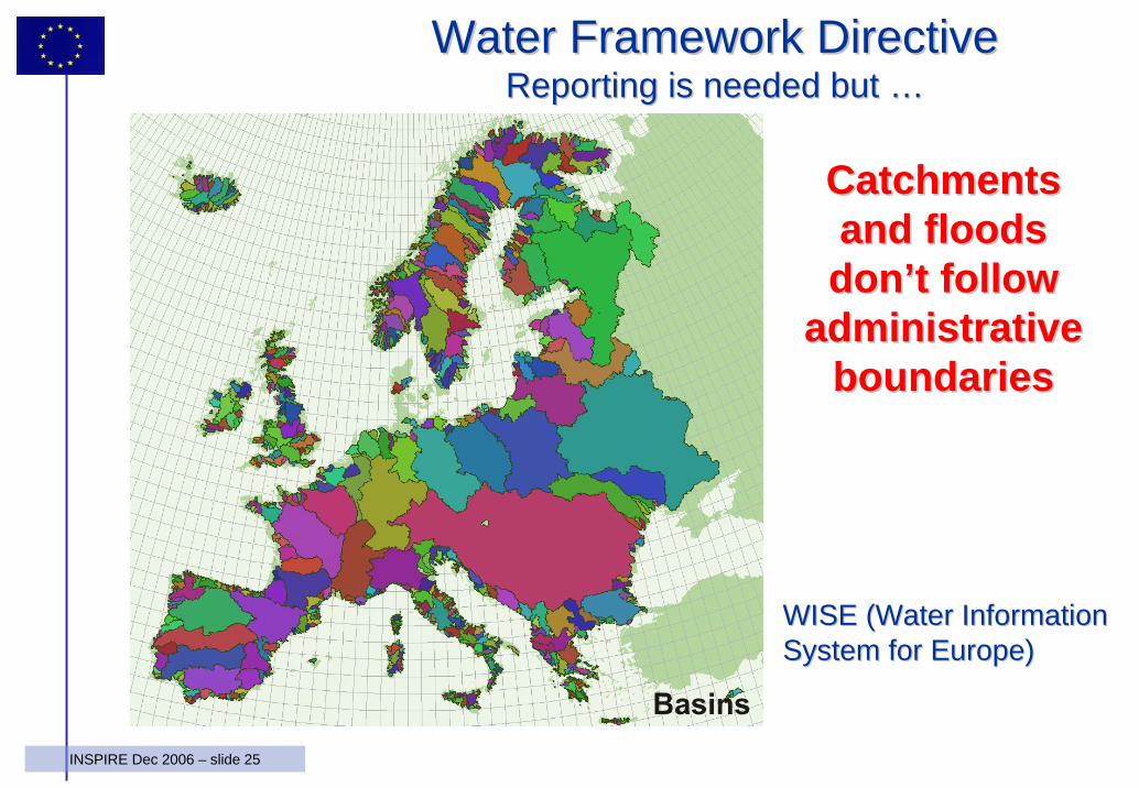
25INSPIRE Dec 2006 – slide 25
Catchments Catchments and floods and floods dondon’’t follow t follow
administrative administrative boundaries boundaries
Water Framework DirectiveWater Framework DirectiveReporting is needed but Reporting is needed but ……
WISE (Water Information WISE (Water Information System for Europe)System for Europe)
26INSPIRE Dec 2006 – slide 26
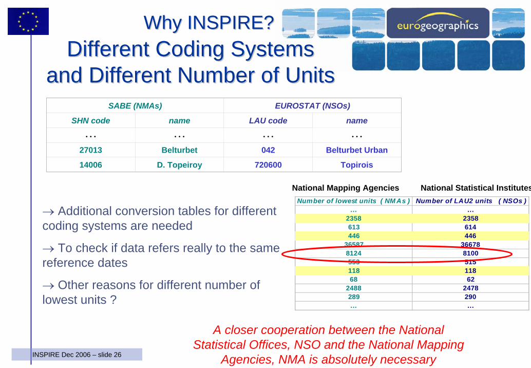
→ Additional conversion tables for different coding systems are needed
→ To check if data refers really to the samereference dates
→ Other reasons for different number of lowest units ?
SABE (NMAs) EUROSTAT (NSOs)
SHN code…
name…
LAU code…
name…
27013 Belturbet 042 Belturbet Urban
14006 D. Topeiroy 720600 Topirois
Different Coding Systems Different Coding Systems and Different Number of Unitsand Different Number of Units
Number of lowest units ( NM As ) Number of LAU2 units ( NSOs )... ...
2358 2358613 614446 446
36587 366788124 8100553 515118 11868 62
2488 2478289 290... ...
National Mapping Agencies National Statistical Institutes
Why INSPIRE?Why INSPIRE?
A closer cooperation between the National Statistical Offices, NSO and the National Mapping
Agencies, NMA is absolutely necessary
27INSPIRE Dec 2006 – slide 27
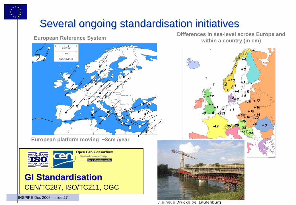
5 cm/year
ITRF93
NNR-NUVEL1A
Differences in sea-level across Europe and within a country (in cm)European Reference System
European platform moving ~3cm /year
SeveralSeveral ongoingongoing standardisationstandardisation initiativesinitiatives
GI GI StandardisationStandardisationCEN/TC287, ISO/TC211, OGC
28INSPIRE Dec 2006 – slide 28
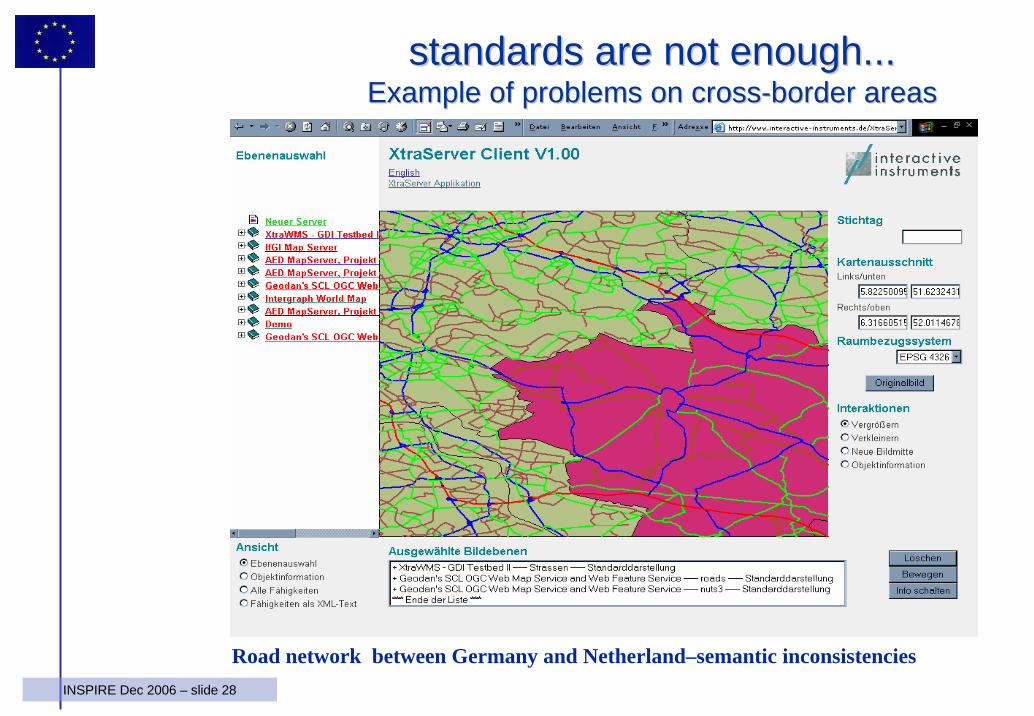
standardsstandards are are notnot enoughenough......ExampleExample of of problemsproblems on on crosscross--borderborder areasareas
Road network between Germany and Netherland–semantic inconsistencies
29INSPIRE Dec 2006 – slide 29
• INSPIRE lays down general rules to establish an infrastructure for spatial information in Europe for the purposes of Community environmental policies and policies or activities which may have an impact on the environment.– This infrastructure shall build upon infrastructures for
spatial information established and operated by the Member States.
• INSPIRE does not require collection of new spatial data – electronic format
• INSPIRE does not affect Intellectual Property Rights
INSPIRE DirectiveINSPIRE DirectiveGeneral ProvisionsGeneral Provisions
30INSPIRE Dec 2006 – slide 30
INSPIRE ELEMENTSINSPIRE ELEMENTS
• METADATA• INTEROPERABILITY OF SPATIAL DATA SETS
AND SERVICES• NETWORK SERVICES• DATA SHARING (policy)• COORDINATION AND COMPLEMENTARY
MEASURES – Monitoring & Reporting
INSPIRE requires also specific implementing rules to be adopted through a Commitology procedure
31INSPIRE Dec 2006 – slide 31
WhatWhat and and WhoseWhose Spatial Data ?Spatial Data ?
• Who ? - Spatial data held by or on behalf of a public authority operating down to the lowest level of government when laws or regulations require their collection or dissemination
• What ? - INSPIRE covers 35 Spatial Data Themes laid down in 3 Annexes – (required to successfully build environmental information systems)
32INSPIRE Dec 2006 – slide 32
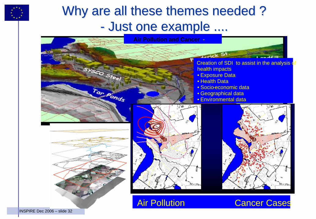
WhyWhy are all are all thesethese themesthemes neededneeded ??-- Just one Just one exampleexample ........
Creation of SDI to assist in the analysis ofhealth impacts• Exposure Data• Health Data• Socio-economic data• Geographical data• Environmental data
Air Pollution and Cancer -
Air Pollution Cancer Cases
33INSPIRE Dec 2006 – slide 33
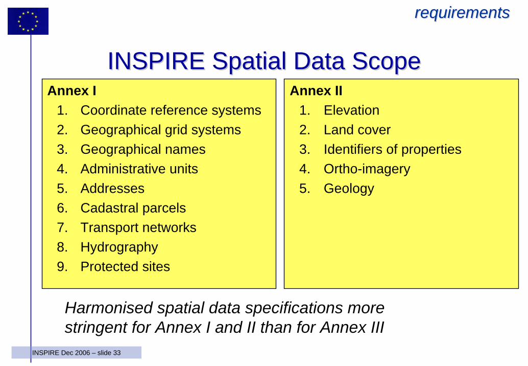
INSPIRE INSPIRE SpatialSpatial Data Data ScopeScopeAnnex I
1. Coordinate reference systems2. Geographical grid systems3. Geographical names4. Administrative units5. Addresses6. Cadastral parcels7. Transport networks8. Hydrography9. Protected sites
Annex II1. Elevation2. Land cover3. Identifiers of properties4. Ortho-imagery5. Geology
Harmonised spatial data specifications more stringent for Annex I and II than for Annex III
requirementsrequirements
34INSPIRE Dec 2006 – slide 34
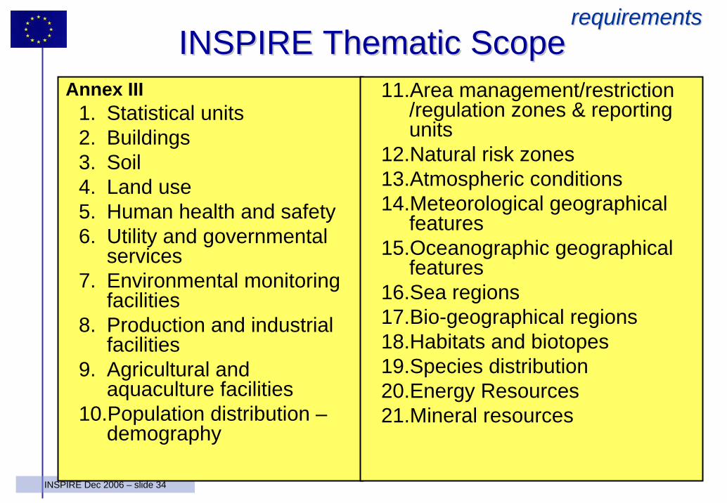
Annex III1. Statistical units2. Buildings3. Soil4. Land use5. Human health and safety6. Utility and governmental
services7. Environmental monitoring
facilities8. Production and industrial
facilities9. Agricultural and
aquaculture facilities10.Population distribution –
demography
11.Area management/restriction/regulation zones & reporting units
12.Natural risk zones13.Atmospheric conditions14.Meteorological geographical
features15.Oceanographic geographical
features16.Sea regions17.Bio-geographical regions18.Habitats and biotopes19.Species distribution20.Energy Resources21.Mineral resources
INSPIRE INSPIRE ThematicThematic ScopeScoperequirementsrequirements
35INSPIRE Dec 2006 – slide 35
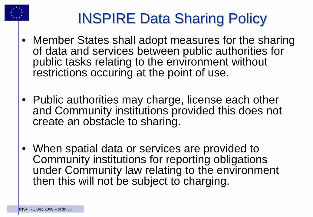
INSPIRE Data Sharing PolicyINSPIRE Data Sharing Policy• Member States shall adopt measures for the sharing
of data and services between public authorities for public tasks relating to the environment withoutrestrictions occuring at the point of use.
• Public authorities may charge, license each otherand Community institutions provided this does not create an obstacle to sharing.
• When spatial data or services are provided to Community institutions for reporting obligations under Community law relating to the environmentthen this will not be subject to charging.
36INSPIRE Dec 2006 – slide 36
From Commission proposal to From Commission proposal to Community Directive implementationCommunity Directive implementation
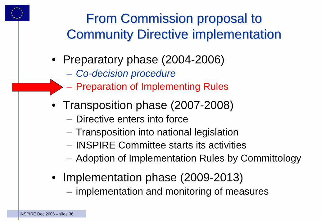
• Preparatory phase (2004-2006)– Co-decision procedure– Preparation of Implementing Rules
• Transposition phase (2007-2008)– Directive enters into force– Transposition into national legislation– INSPIRE Committee starts its activities– Adoption of Implementation Rules by Committology
• Implementation phase (2009-2013)– implementation and monitoring of measures
37INSPIRE Dec 2006 – slide 37
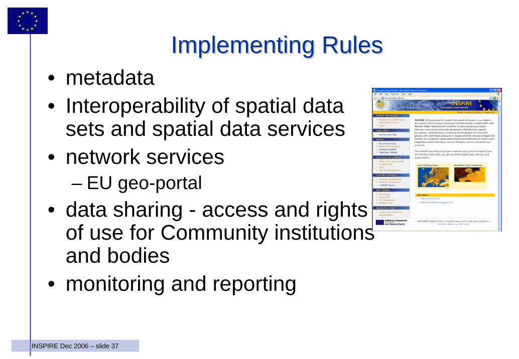
Implementing RulesImplementing Rules• metadata• Interoperability of spatial data
sets and spatial data services• network services
– EU geo-portal• data sharing - access and rights
of use for Community institutions and bodies
• monitoring and reporting
38INSPIRE Dec 2006 – slide 38
MetadataMetadata
Member States shall create metadata and keep themup to date
• Metadata shall include:– Conditions for access and use– Quality and validity– The public authorities responsible– Limitations on public access
• Once Implementing Rules adopted:– Created within two years for Annex I, II– Created within 5 years for Annex II
39INSPIRE Dec 2006 – slide 39
Interoperability of spatial data sets and servicesInteroperability of spatial data sets and servicesImplementing Rules, IR shall be adopted for interoperability and
,where practical, for harmonisation of spatial data sets and services
• Based on relevant user requirements• Integrate existing international standards, if appropriate• Feasible, proportionate, cost-benefit into account (Member
States shall provide on request information)• Member States shall once IR adopted:
– Make services and new data conform within 2 years– Make existing data conform (can be done through transformation
service) within 7 years• Stakeholders shall be given opportunity to participate in
development of this Implementing Rule
requirementsrequirements
40INSPIRE Dec 2006 – slide 40
Interoperability of spatial data sets and services Interoperability of spatial data sets and services (2)(2)
requirementsrequirements
• Harmonised data specifications– Annex I, II, III:
• definition and classification of spatial objects• geo-referencing
– Annex I, II:• common framework of unique identifiers for spatial objects;• relationship between spatial objects;• key attributes and corresponding multilingual thesauri;• Information on the temporal dimension of the data;• how to exchange updates of the data.
• 3rd parties shall have access to these specifications at conditions not restricting its use
• Cross-border issues shall be agreed on
41INSPIRE Dec 2006 – slide 41
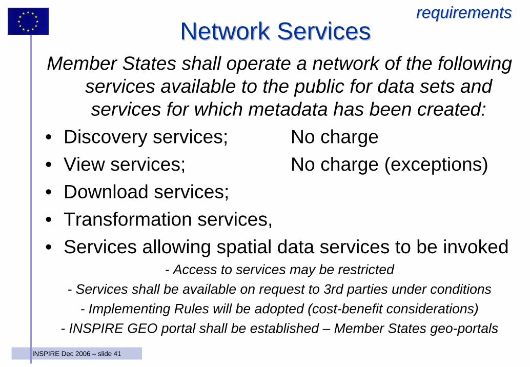
Network ServicesNetwork ServicesMember States shall operate a network of the following
services available to the public for data sets and services for which metadata has been created:
• Discovery services; No charge• View services; No charge (exceptions)• Download services; • Transformation services, • Services allowing spatial data services to be invoked
- Access to services may be restricted- Services shall be available on request to 3rd parties under conditions
- Implementing Rules will be adopted (cost-benefit considerations) - INSPIRE GEO portal shall be established – Member States geo-portals
requirementsrequirements
42INSPIRE Dec 2006 – slide 42
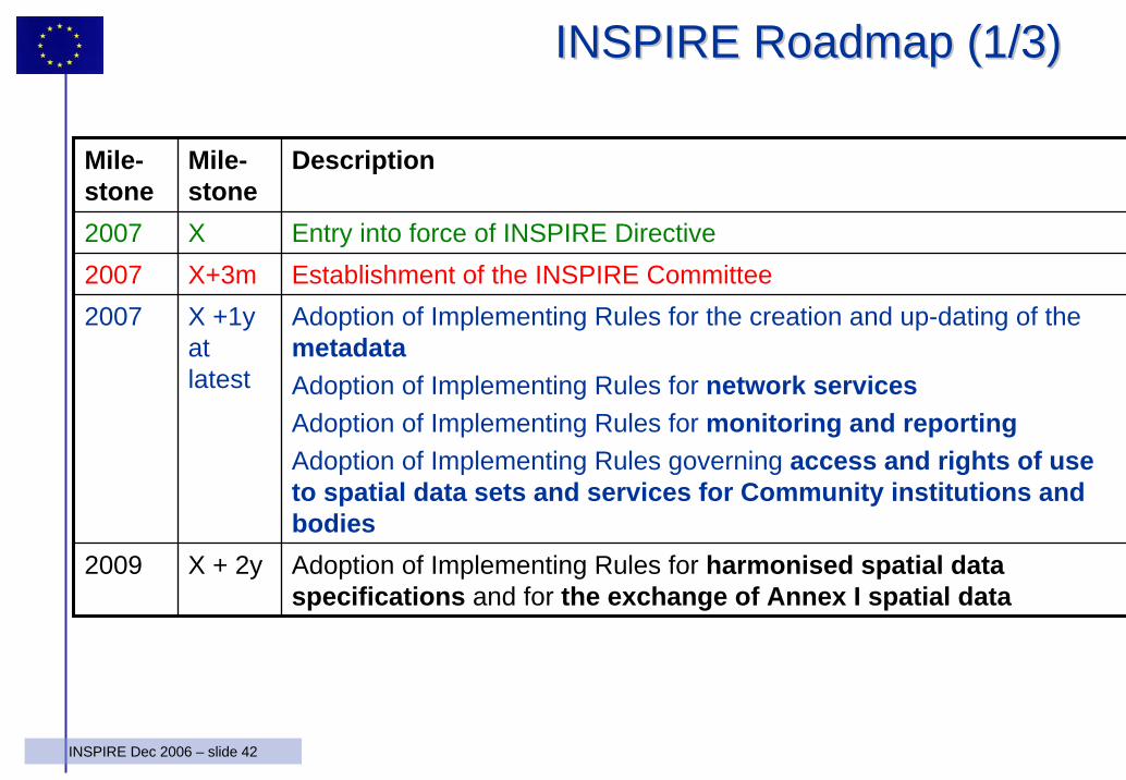
INSPIRE INSPIRE Roadmap (Roadmap (1/3)1/3)
Mile-stone
Mile-stone
Description
2007 X Entry into force of INSPIRE Directive2007 X+3m Establishment of the INSPIRE Committee2007 X +1y
at latest
Adoption of Implementing Rules for the creation and up-dating of the metadataAdoption of Implementing Rules for network servicesAdoption of Implementing Rules for monitoring and reportingAdoption of Implementing Rules governing access and rights of use to spatial data sets and services for Community institutions andbodies
2009 X + 2y Adoption of Implementing Rules for harmonised spatial data specifications and for the exchange of Annex I spatial data
43INSPIRE Dec 2006 – slide 43
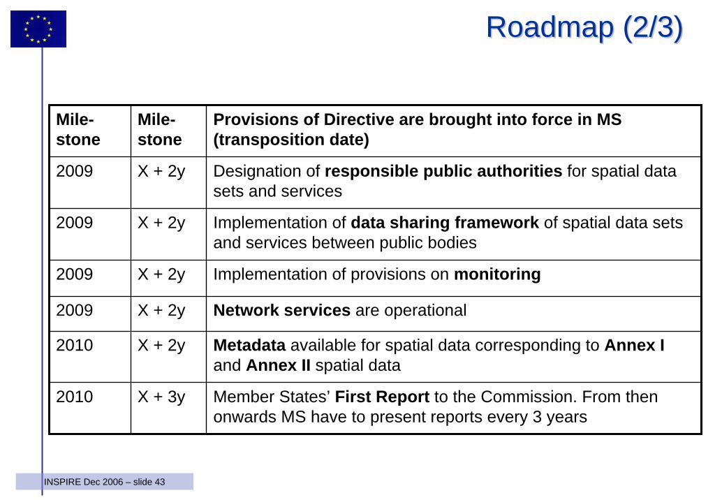
Mile-stone
Mile-stone
Provisions of Directive are brought into force in MS (transposition date)
2009 X + 2y Designation of responsible public authorities for spatial data sets and services
2009 X + 2y Implementation of data sharing framework of spatial data sets and services between public bodies
2009 X + 2y Implementation of provisions on monitoring
2009 X + 2y Network services are operational
2010 X + 2y Metadata available for spatial data corresponding to Annex Iand Annex II spatial data
2010 X + 3y Member States’ First Report to the Commission. From then onwards MS have to present reports every 3 years
RoadmapRoadmap (2/3)(2/3)
44INSPIRE Dec 2006 – slide 44
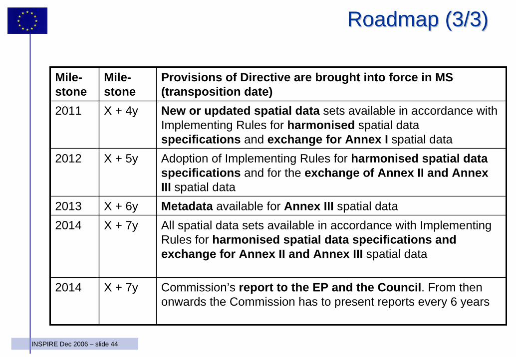
Mile-stone
Mile-stone
Provisions of Directive are brought into force in MS (transposition date)
2011 X + 4y New or updated spatial data sets available in accordance with Implementing Rules for harmonised spatial data specifications and exchange for Annex I spatial data
2012 X + 5y Adoption of Implementing Rules for harmonised spatial data specifications and for the exchange of Annex II and Annex III spatial data
2013 X + 6y Metadata available for Annex III spatial data2014 X + 7y All spatial data sets available in accordance with Implementing
Rules for harmonised spatial data specifications and exchange for Annex II and Annex III spatial data
2014 X + 7y Commission’s report to the EP and the Council. From then onwards the Commission has to present reports every 6 years
RoadmapRoadmap (3/3)(3/3)
45INSPIRE Dec 2006 – slide 45
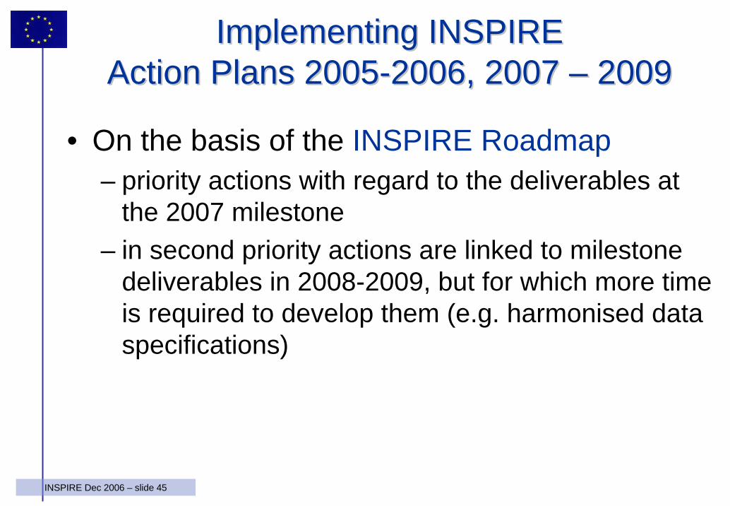
Implementing INSPIREImplementing INSPIREAction Plans 2005Action Plans 2005--2006, 2007 2006, 2007 –– 20092009
• On the basis of the INSPIRE Roadmap– priority actions with regard to the deliverables at
the 2007 milestone– in second priority actions are linked to milestone
deliverables in 2008-2009, but for which more time is required to develop them (e.g. harmonised data specifications)
46INSPIRE Dec 2006 – slide 46
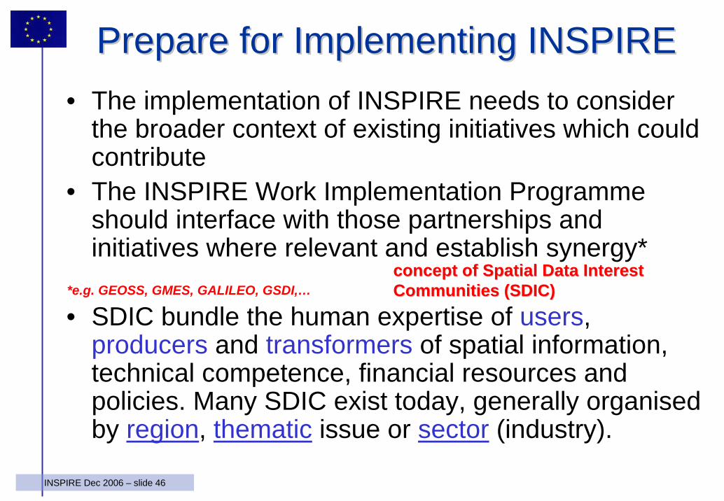
Prepare for Implementing INSPIREPrepare for Implementing INSPIRE• The implementation of INSPIRE needs to consider
the broader context of existing initiatives which could contribute
• The INSPIRE Work Implementation Programmeshould interface with those partnerships and initiatives where relevant and establish synergy*
• SDIC bundle the human expertise of users, producers and transformers of spatial information, technical competence, financial resources and policies. Many SDIC exist today, generally organised by region, thematic issue or sector (industry).
concept of Spatial Data Interest concept of Spatial Data Interest Communities (SDIC)Communities (SDIC)*e.g. GEOSS, GMES, GALILEO, GSDI,…
47INSPIRE Dec 2006 – slide 47
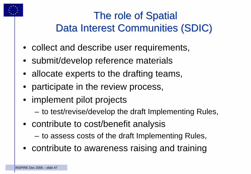
The role of Spatial The role of Spatial Data Interest Communities (SDIC)Data Interest Communities (SDIC)
• collect and describe user requirements, • submit/develop reference materials• allocate experts to the drafting teams,• participate in the review process, • implement pilot projects
– to test/revise/develop the draft Implementing Rules, • contribute to cost/benefit analysis
– to assess costs of the draft Implementing Rules, • contribute to awareness raising and training
48INSPIRE Dec 2006 – slide 48
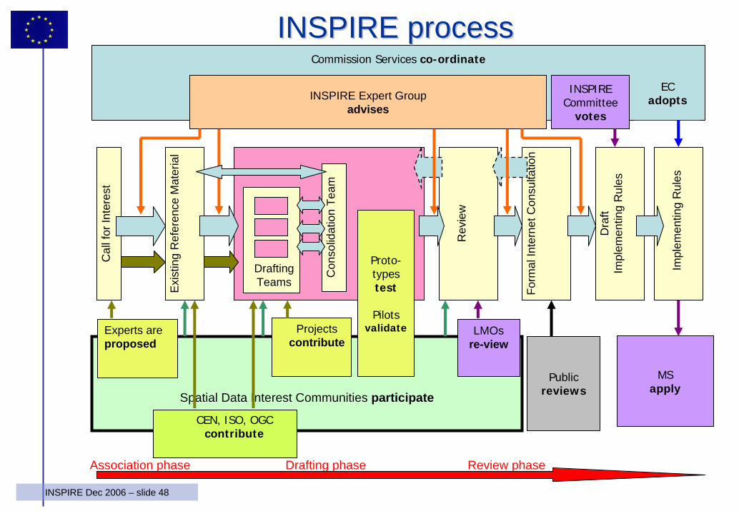
Commission Services co-ordinate
Spatial Data Interest Communities participate
Projectscontribute
Drafting Teams
Con
solid
atio
n Te
am
Proto-typestest
Pilotsvalidate
CEN, ISO, OGC contribute
INSPIRE Expert Groupadvises
INSPIRECommittee
votes
ECadopts
Publicreviews
Impl
emen
ting
Rul
es
Dra
ft Im
plem
entin
g R
ules
Form
al In
tern
et C
onsu
ltatio
n
Rev
iew
Cal
l for
Inte
rest
Exis
ting
Ref
eren
ce M
ater
ial
Experts are proposed
Association phase Drafting phase Review phase
LMOsre-view
MSapply
INSPIRE processINSPIRE process
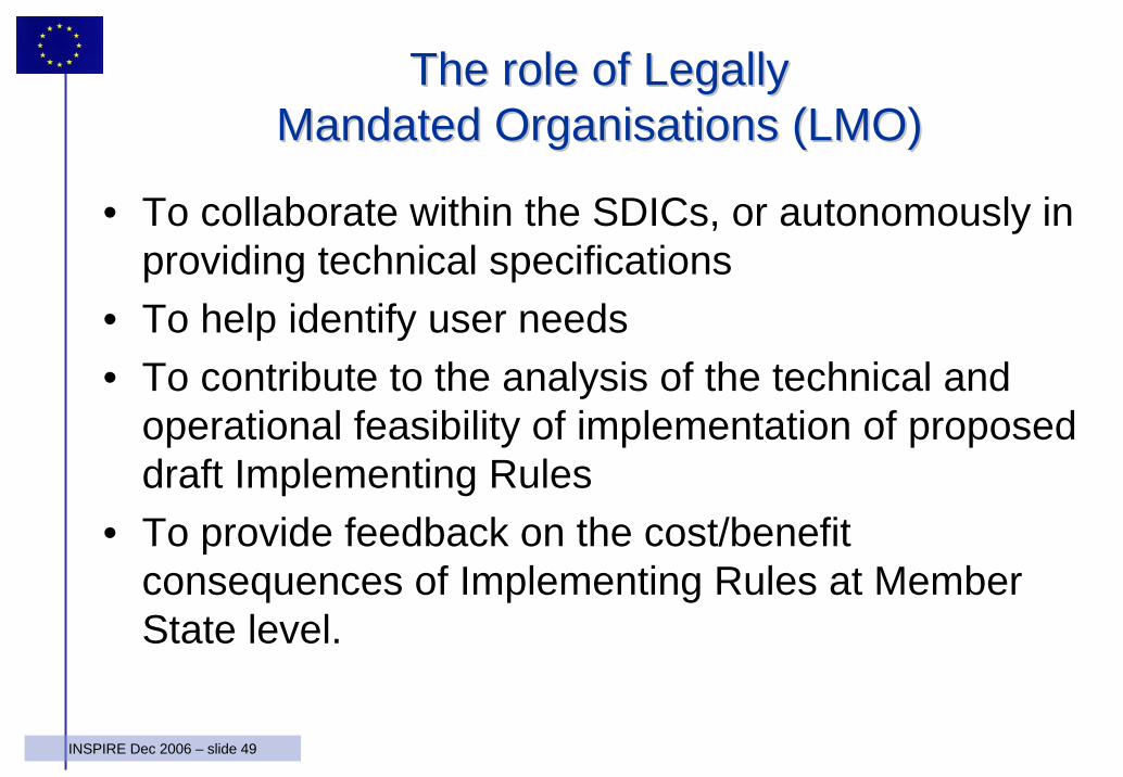
49INSPIRE Dec 2006 – slide 49
The role of Legally The role of Legally Mandated Organisations (LMO)Mandated Organisations (LMO)
• To collaborate within the SDICs, or autonomously in providing technical specifications
• To help identify user needs • To contribute to the analysis of the technical and
operational feasibility of implementation of proposed draft Implementing Rules
• To provide feedback on the cost/benefit consequences of Implementing Rules at Member State level.
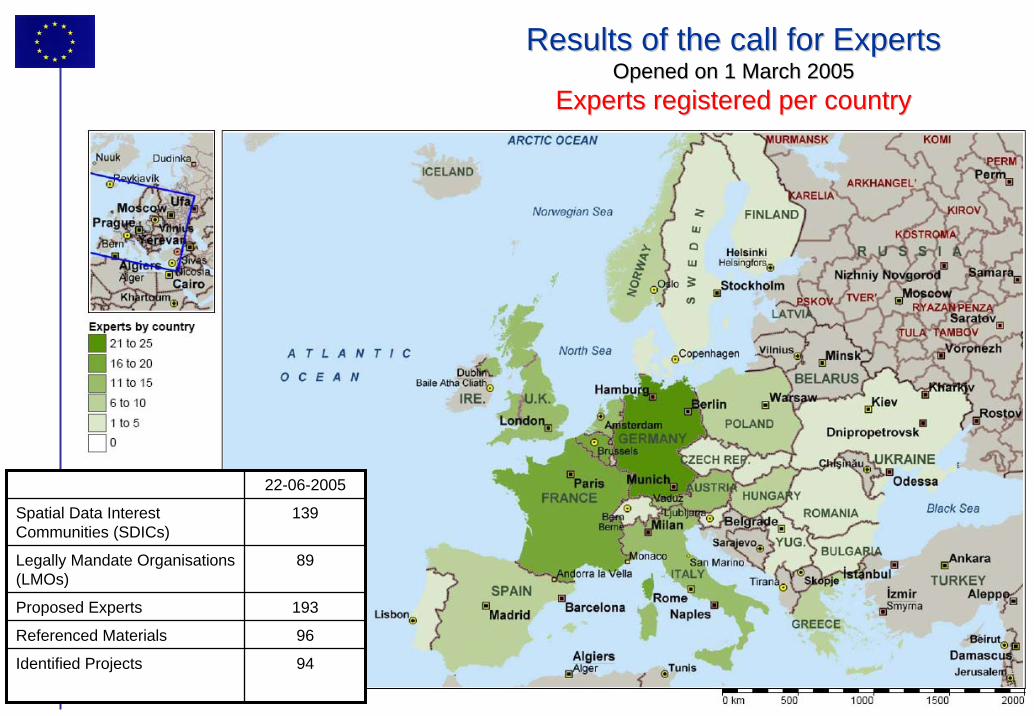
50INSPIRE Dec 2006 – slide 50
22-06-2005
Spatial Data Interest Communities (SDICs)
139
Legally Mandate Organisations(LMOs)
89
Proposed Experts 193
Referenced Materials 96
Identified Projects 94
Results of the call for ExpertsResults of the call for ExpertsOpened on 1 March 2005Opened on 1 March 2005
Experts registered per countryExperts registered per country
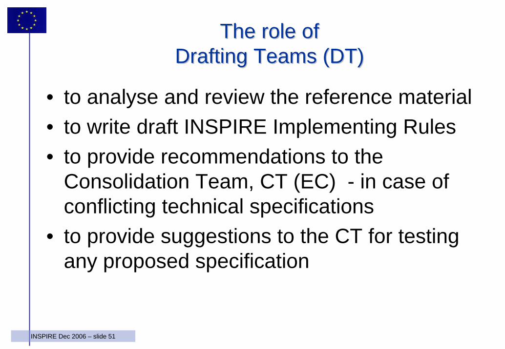
51INSPIRE Dec 2006 – slide 51
The role of The role of Drafting Teams (DT)Drafting Teams (DT)
• to analyse and review the reference material• to write draft INSPIRE Implementing Rules• to provide recommendations to the
Consolidation Team, CT (EC) - in case of conflicting technical specifications
• to provide suggestions to the CT for testing any proposed specification
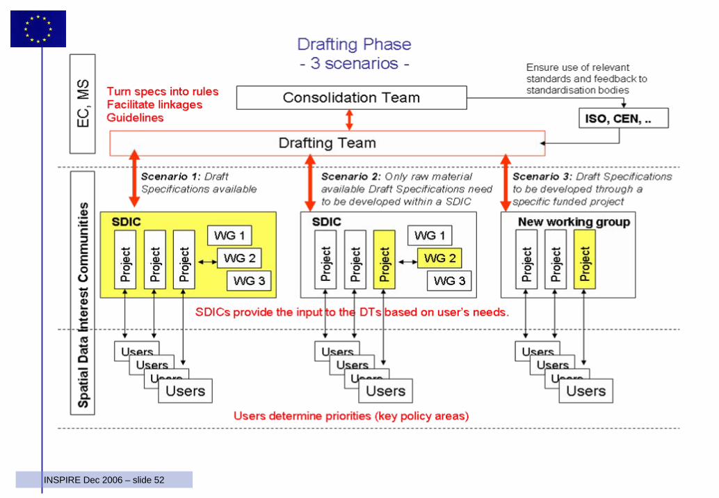
52INSPIRE Dec 2006 – slide 52
53INSPIRE Dec 2006 – slide 53
The role of projects, pilots and prototypesThe role of projects, pilots and prototypes
• develop representative use-case scenarios• develop/test specifications for IR development• demonstrate the feasibility and advantages of
interoperability-based solutions• acquire experience in implementing
interoperability-based solutions• determine cost and benefit of interoperability
based solutions on the basis of real cases
54INSPIRE Dec 2006 – slide 54
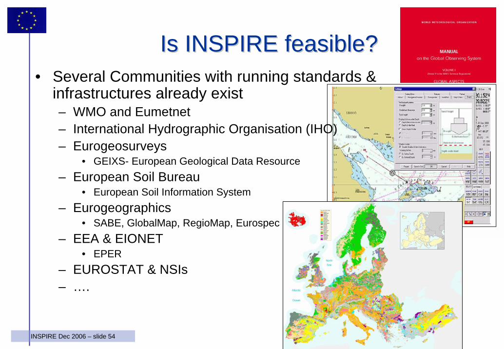
Is INSPIRE feasible?Is INSPIRE feasible?• Several Communities with running standards &
infrastructures already exist – WMO and Eumetnet– International Hydrographic Organisation (IHO)– Eurogeosurveys
• GEIXS- European Geological Data Resource – European Soil Bureau
• European Soil Information System– Eurogeographics
• SABE, GlobalMap, RegioMap, Eurospec– EEA & EIONET
• EPER– EUROSTAT & NSIs– ….
55INSPIRE Dec 2006 – slide 55
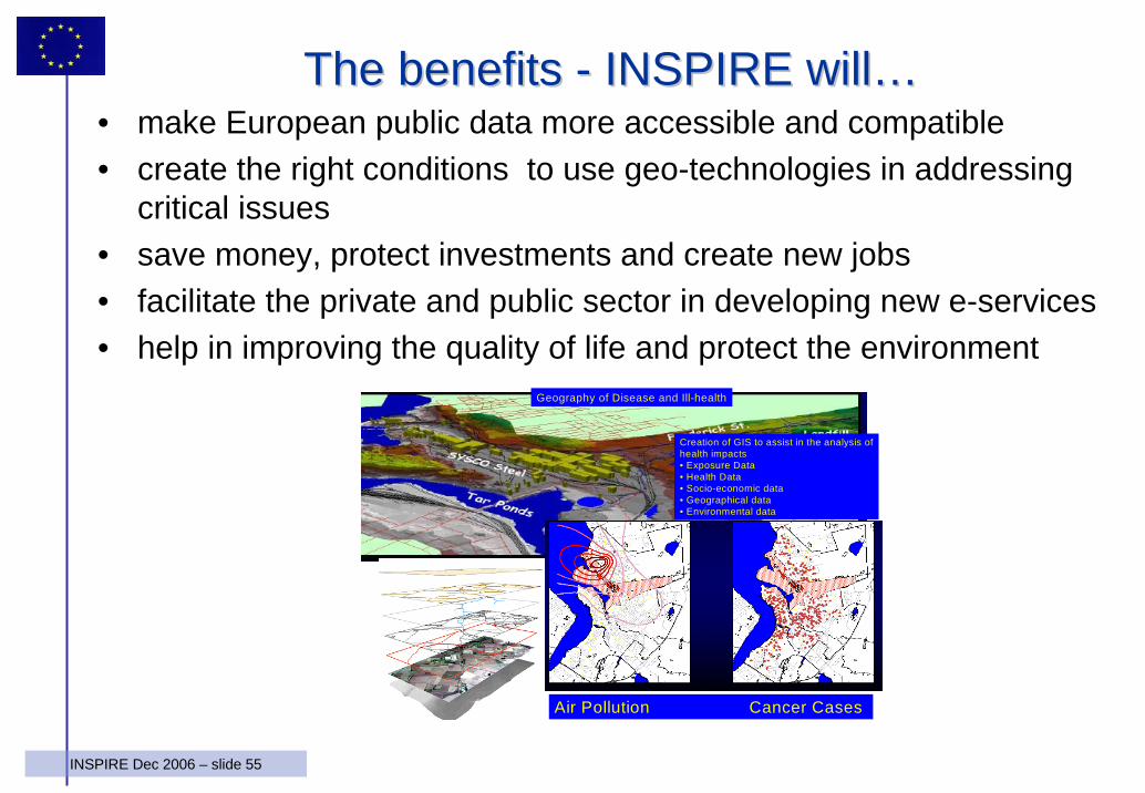
The benefits The benefits -- INSPIRE willINSPIRE will……• make European public data more accessible and compatible• create the right conditions to use geo-technologies in addressing
critical issues• save money, protect investments and create new jobs• facilitate the private and public sector in developing new e-services• help in improving the quality of life and protect the environment
Creation of GIS to assist in the analysis ofhealth impacts• Exposure Data• Health Data• Socio-economic data• Geographical data• Environmental data
Geography of Disease and Ill-health
Air Pollution Cancer Cases
56INSPIRE Dec 2006 – slide 56
ConclusionsConclusions
• INSPIRE is a framework Directive with implementing rules to be defined in the coming years
• Initial focus on environmental policies will be enlarged to other sectors in future
• Highest involvement of key stakeholders through the “Spatial Data Interest Community” concept is needed for proper development
• Openness and transparency in drafting implementing measures will be followed
• Pilots and Projects could play a key role to define and validate the implementing rules
• Link and interface with international initiatives must be strengthened – GEO/GEOSS
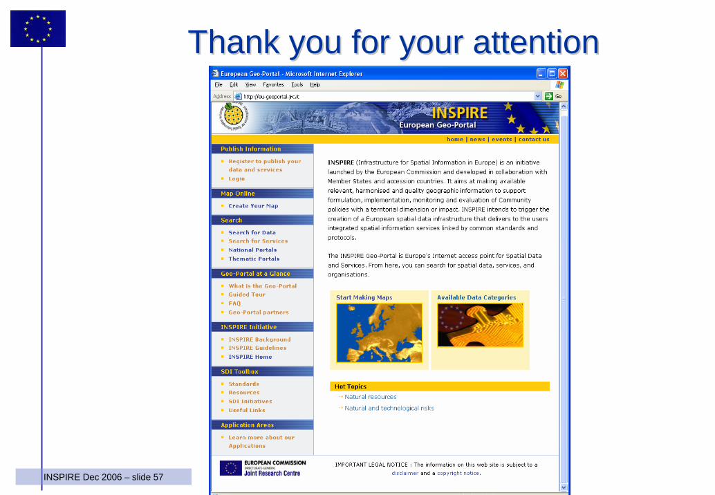
57INSPIRE Dec 2006 – slide 57
ThankThank youyou for for youryour attentionattention