Embed Size (px)
Citation preview
1
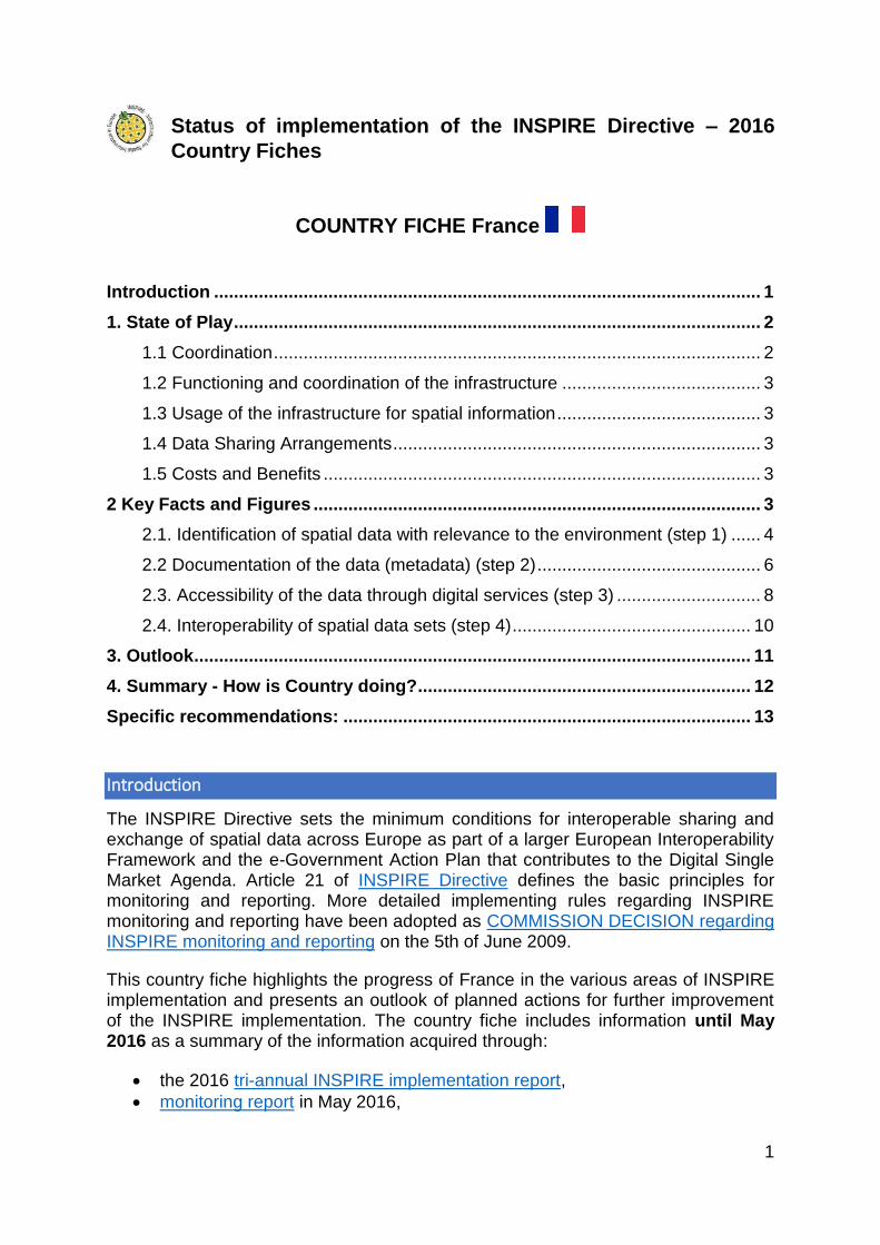
Status of implementation of the INSPIRE Directive – 2016
Country Fiches
COUNTRY FICHE France
Introduction .............................................................................................................. 1
1. State of Play .......................................................................................................... 2
1.1 Coordination .................................................................................................. 2
1.2 Functioning and coordination of the infrastructure ........................................ 3
1.3 Usage of the infrastructure for spatial information ......................................... 3
1.4 Data Sharing Arrangements .......................................................................... 3
1.5 Costs and Benefits ........................................................................................ 3
2 Key Facts and Figures .......................................................................................... 3
2.1. Identification of spatial data with relevance to the environment (step 1) ...... 4
2.2 Documentation of the data (metadata) (step 2) ............................................. 6
2.3. Accessibility of the data through digital services (step 3) ............................. 8
2.4. Interoperability of spatial data sets (step 4) ................................................ 10
3. Outlook ................................................................................................................ 11
4. Summary - How is Country doing? ................................................................... 12
Specific recommendations: .................................................................................. 13
Introduction
The INSPIRE Directive sets the minimum conditions for interoperable sharing and exchange of spatial data across Europe as part of a larger European Interoperability Framework and the e-Government Action Plan that contributes to the Digital Single Market Agenda. Article 21 of INSPIRE Directive defines the basic principles for monitoring and reporting. More detailed implementing rules regarding INSPIRE monitoring and reporting have been adopted as COMMISSION DECISION regarding INSPIRE monitoring and reporting on the 5th of June 2009.
This country fiche highlights the progress of France in the various areas of INSPIRE implementation and presents an outlook of planned actions for further improvement of the INSPIRE implementation. The country fiche includes information until May 2016 as a summary of the information acquired through:
the 2016 tri-annual INSPIRE implementation report,
monitoring report in May 2016,
2
a bilateral written exchange on the implementation of the INSPIRE Directive between the Commission and France representatives.
1. State of Play
A high-level view on the governance, use and impact of the INSPIRE Directive in France. More detailed information is available on the INSPIRE knowledge base.
The content of the chapter is tagged according to 5 criteria of better regulation:
[Effectiveness] How successful has the INSPIRE implementation been in achieving, progressing towards its objectives; progress made, gaps, what factors have influenced or why it has not yet been achieved regarding availability of services, data interoperability, sharing, data policy obstacles
[Efficiency] Costs (numbers or difficulties to evaluate them); benefits (qualitative or quantitative) already visible.
[Relevance] Is it still relevant to make data interoperable, remove obstacles of data sharing, drive collaboration between public services, necessary for National SDI, use cross-sector, requested by eGovernment, modernisation of public admin, etc.; support given by National Institutions for implementation
[Coherence] Internal coherence of INSPIRE provisions proved by implementation; cross-border applications; coherence with other National and EU policies
[EU-added value] Improvement of EU cross-border data management and use; use for environmental monitoring and reporting, use for and with Copernicus data; use cross-sector.
1.1 Coordination
National Contact point
Name of public authority Directeur de la Recherche et de l’Innovation au ministère de l’environnement, de l’énergie et de la mer
Mailing address Tour Sequoia, 92055 La Défense Cedex, France
Telephone number +33 (0)1 40 81 21 22
Fax number
E-mail Point-de-contact-inspire-france.dri.cgdd@developpementdurable.gouv.fr
Website address www.developpement-durable.gouv.fr
Contact person Serge BOSSINI
Telephone number
Contact person substitute
Telephone number
Coordination Structure o NCP is the permanent secretary of Conseil National de l'Information Géographique- CNIG
www.cnig.gouv.fr, which is the coordination structure, composed by 35 members. It chairs 6 Commissions or working groups
o Local level is coordinated by regional platforms of geographic information (law NOTRe of 7 August 2015)
o COmmission de VAlidation des Données pour l’Information Spatialisée (COVADIS) is an inter-
ministry Environment and Agriculture structure to establish standards/convert the existing ones
to be INSPIRE compliant, for the quality assurance of the infrastructure (Art.12.2), including
Regulation n°1089/2010/CE on interoperability, to be used by the services of both ministries
[Relevance]. This structure participated in the development of the data model of standard
PCRS.
3
Progress o Central role of the Conseil national de l'information géographique (CNIG), producing guidelines
with recommendations and geostandards to prevent the damage of the underground networks.
1.2 Functioning and coordination of the infrastructure
Extremely sustained dynamics of creating open data catalogues, especially for Themes of Annex III. [Effectiveness]
Remarkable surge of data available for download. [Effectiveness]
Establishment of data interoperability in Annex III by national geostandards meeting concrete needs, in accordance with the Interoperability Regulation (examples in the Report and in this fiche). [Effectiveness] [Coherence] [Relevance].
1.3 Usage of the infrastructure for spatial information
The program « Dîtes-le nous une fois » started in 2013 to reduce redundancy of information asked to enterprises and administrative burden, IGN developed the mapping component with API Carto to simplify tasks of admin and of the users, based on INSPIRE ; it is used in all electronic forms [Coherence] [Relevance] for different applications (e.g. permits to plan vineyards, automatic calculation of surface of cadastre parcels involved), saving time, reducing errors, reuse authoritative information provided by other public admin implementing INSPIRE.
Several testimony prove that public admin have been able to explore INSPIRE infrastructure to satisfy the everyday needs of citizens. [Relevance]
“passerelle Inspire” to the National Open data as a set of tools to publish geographic datasets "INSPIRE" on the platform of the French public data data.gouv.fr [Coherence] [Relevance]
Partnership in ELF project.
1.4 Data Sharing Arrangements
There are no procedural obstacles to share data (relevant law exist), only cultural obstacles
and technical to a lower extent.
1.5 Costs and Benefits
Progress on accessing costs: there are no new elements on costs.
Progress on accessing benefits: Several examples of benefits are documented with
references and contact point.
Benefits already tangible by using API Carte http://apicarto.ign.fr/. [Efficiency]
Benefits already for the citizens and the public services with regional platform like
http://geobretagne.fr
2 Key Facts and Figures
In addition to the above mentioned issues, the implementation of INSPIRE Directive
requires Member States to take four main steps in relation to management of spatial
datasets which fall under the Directive:
Step 1: Identify spatial datasets
Step 2: Document these datasets (metadata)
Step 3: Provide services for identified spatial datasets (discovery, view,
download)
Step 4: Make spatial datasets interoperable by aligning them with the
common data models.
The key facts and figures presented in this country fiche are based on the
information provided by France on the INSPIRE dashboard. The provided statistics

4
is not reflecting the data available on INSPIRE geoportal. The INSPIRE geoportal
is updated on a regular and ongoing basis, whilst the INSPIRE dashboard is typically
updated after every reporting round, on a yearly basis.
The conformity of the implementation is assessed against the full set of legal
specifications set out by the Directive and the Implementing Rules and the
commonly agreed good practices set out by the technical guidelines.
2.1. Identification of spatial data with relevance to the environment (step 1)
a. Evolution of the data offering
DSv_Num: number of spatial data sets for all Annexes
b. Data sets made available per INSPIRE theme in 2015
5
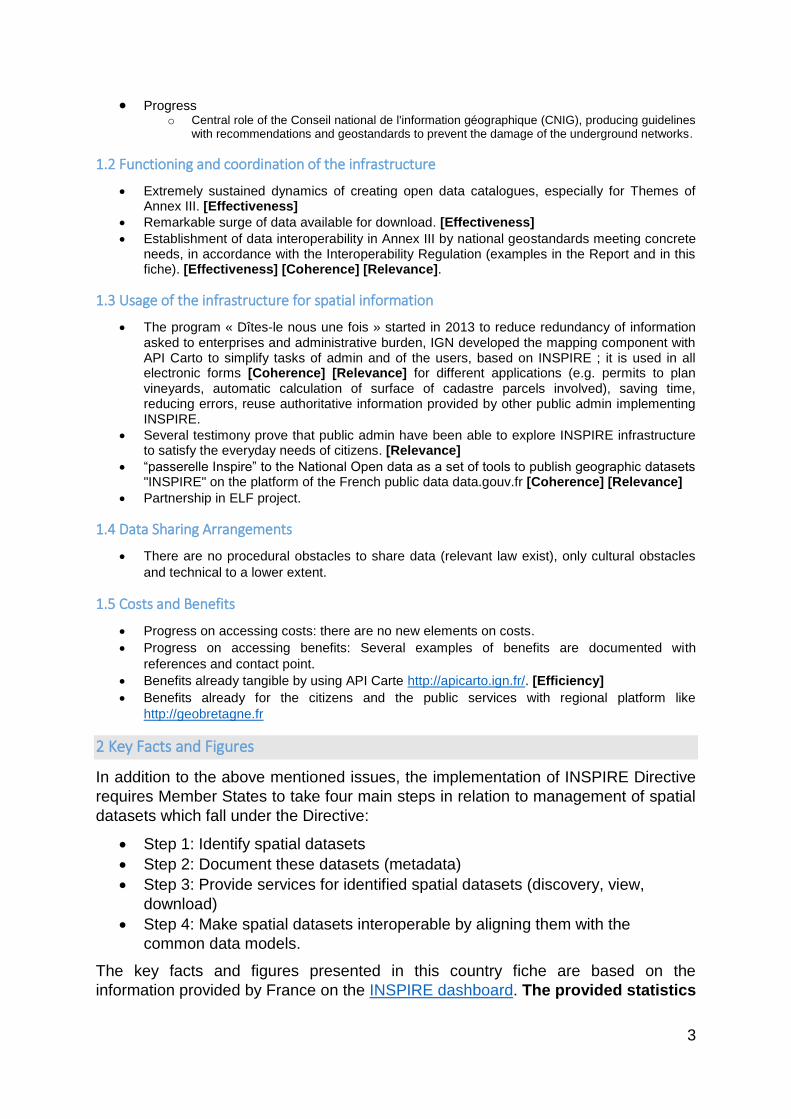
c. Data sets per annex (Annex 1 & 2: spatial reference data; Annex 3: environmental spatial
data) MDv1.1 (yellow): number of spatial data sets for Annex I that have metadata
MDv1.2 (green): number of spatial data sets for Annex II that have metadata
MDv1.3 (blue): number of spatial data sets for Annex III that have metadata
Evaluation of progress for step 1:
France has identified a total of 30452 spatial data sets with relation to the
themes listed in the INSPIRE annexes.
Very big increase in spatial data sets identification could be seen from 2014 onwards
under all INSPIRE data themes. Many relevant spatial data sets have already been
identified for the different data themes. Further improvement is expected by
identifying and documenting spatial data sets required under the existing reporting
and monitoring regulations of EU environmental law.

6
2.2 Documentation of the data (metadata) (step 2)
a. Evolution of documented data and conformity of the documentation MDv1_DS (green): number of spatial data sets for all Annexes that have metadata
MDv2_DS (yellow): number of spatial data sets for all Annexes that have conformant metadata
b. Documented data per annex in 2015 MDv2.1 (green): number of spatial data sets for Annex I that have conformant metadata
MDv2.2 (yellow): number of spatial data sets for Annex II that have conformant metadata
MDv2.3 (blue): number of spatial data sets for Annex III that have conformant metadata
7
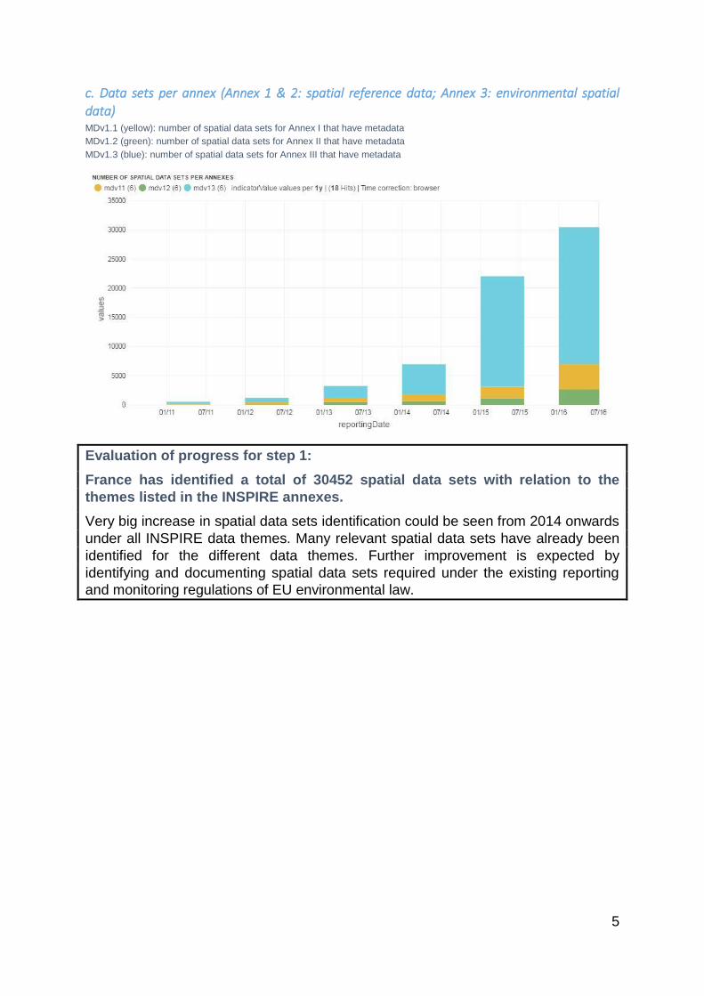
c. Evolution of documented services and conformity of the documentation MDv1.4 (green): number of spatial data services that have metadata
MDv2.4 (yellow): number of spatial data services that have conformant metadata
d. Evolution of the overall conformity of the documented metadata
MDi2 = (number of spatial data sets for all Annexes that have conformant metadata + number of spatial data services that have
conformant metadata) / (number of spatial data sets for all Annexes + number of spatial data services)
Evaluation of progress for step 2:
France has documented and published metadata through a digital discovery
service for 100% of the identified spatial data sets and 100% (4021) of the
digital services. Overall, 90% of the France metadata conforms to the INSPIRE
metadata specifications.
8
It shows a very high level of maturity. Metadata conformity is very high but could be
completed for the reaming datasets.
2.3. Accessibility of the data through digital services (step 3)
a. Digitally accessible spatial data per INSPIRE theme in 2015
Note: This figure reflects the amount of spatial data sets made available through a digital service, not the amount
of available digital services. A digital service can make several spatial data sets available.
b. Evolution of spatial data made accessible through digital services MDv1_DS (green): number of spatial data sets for all Annexes that have metadata
NSv2.1 yellow): number of spatial data sets for which a view service exists
NSv2.2 (blue): number of spatial data sets for which a download service exists
NSv2.3 (orange): number of spatial data sets for which both a view and a download service exists
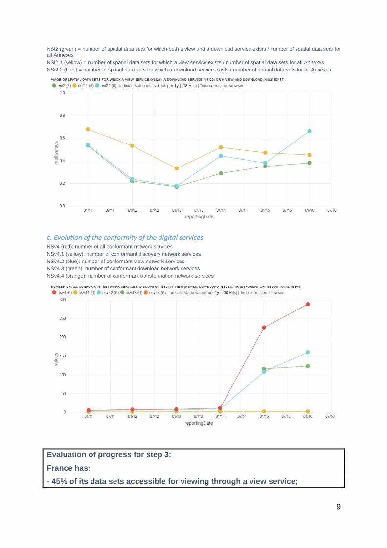
9
NSi2 (green) = number of spatial data sets for which both a view and a download service exists / number of spatial data sets for all Annexes
NSi2.1 (yellow) = number of spatial data sets for which a view service exists / number of spatial data sets for all Annexes
NSi2.2 (blue) = number of spatial data sets for which a download service exists / number of spatial data sets for all Annexes
c. Evolution of the conformity of the digital services NSv4 (red): number of all conformant network services
NSv4.1 (yellow): number of conformant discovery network services
NSv4.2 (blue): number of conformant view network services
NSv4.3 (green): number of conformant download network services
NSv4.4 (orange): number of conformant transformation network services
Evaluation of progress for step 3:
France has:
- 45% of its data sets accessible for viewing through a view service;
10
- 66% of its data sets accessible for download through a download service.
Small number of the available digital services are conform to the INSPIRE
network service specifications (8 %).
France shows that it has built the necessary capacity and competences to make
data accessible through digital INSPIRE network services. The technical conformity
of the available services with the INSPIRE network service should be improved.
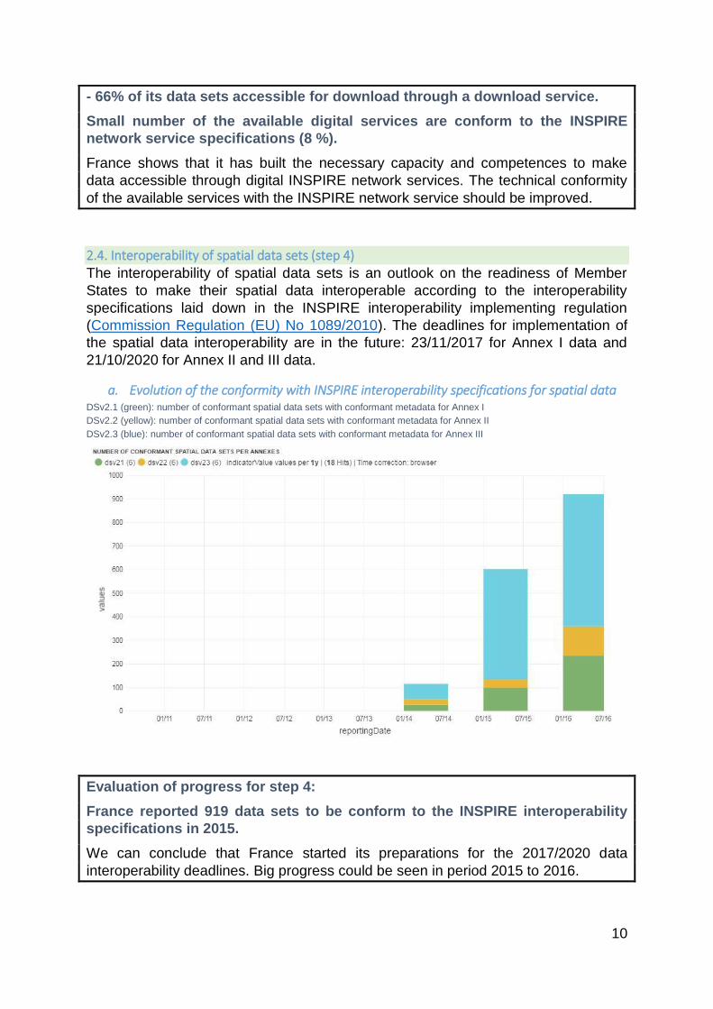
2.4. Interoperability of spatial data sets (step 4) The interoperability of spatial data sets is an outlook on the readiness of Member
States to make their spatial data interoperable according to the interoperability
specifications laid down in the INSPIRE interoperability implementing regulation
(Commission Regulation (EU) No 1089/2010). The deadlines for implementation of
the spatial data interoperability are in the future: 23/11/2017 for Annex I data and
21/10/2020 for Annex II and III data.
a. Evolution of the conformity with INSPIRE interoperability specifications for spatial data DSv2.1 (green): number of conformant spatial data sets with conformant metadata for Annex I
DSv2.2 (yellow): number of conformant spatial data sets with conformant metadata for Annex II
DSv2.3 (blue): number of conformant spatial data sets with conformant metadata for Annex III
Evaluation of progress for step 4:
France reported 919 data sets to be conform to the INSPIRE interoperability
specifications in 2015.
We can conclude that France started its preparations for the 2017/2020 data
interoperability deadlines. Big progress could be seen in period 2015 to 2016.

11
3. Outlook
France has reviewed their INSPIRE implementation and provided an action plan in
2016 to remediate existing implementation issues and further improve the overall
conformity of the implementation.
a. Coordination (1.1; 1.2)
The Action Plan will include an inventory of spatial data for environmental reporting and those which have been allocated to them.
The French authorities undertook to ensure that the data that are already online that could be in line with the requirements of the INSPIRE Directive before the end of the year 2016, and that the remaining data are published in the same way before 31 December 2018.
The Action Plan is therefore primarily focused to the creation and the refitting of existing methods of dissemination.
b. Data sharing and exchange (1.4)
c. Metadata (2.2)
d. Network services (2.3)
This inventory has been carried out and it was found that most of the geographic data are actually accessible online, sometimes for several years, and that the gap to full compliance with the requirements of the INSPIRE Directive lies in the adaptation to Regulation No 976/2009 concerning network services.
Consultation of data services in accordance with Regulation No 976/2009 will be established by the end of 2018.
e. Data Interoperability (2.4)
The action plan sets out the modalities of implementation of the interoperability of data of Annex I to the INSPIRE Directive intended to meet the requirement of harmonisation by the end of 2017.
12
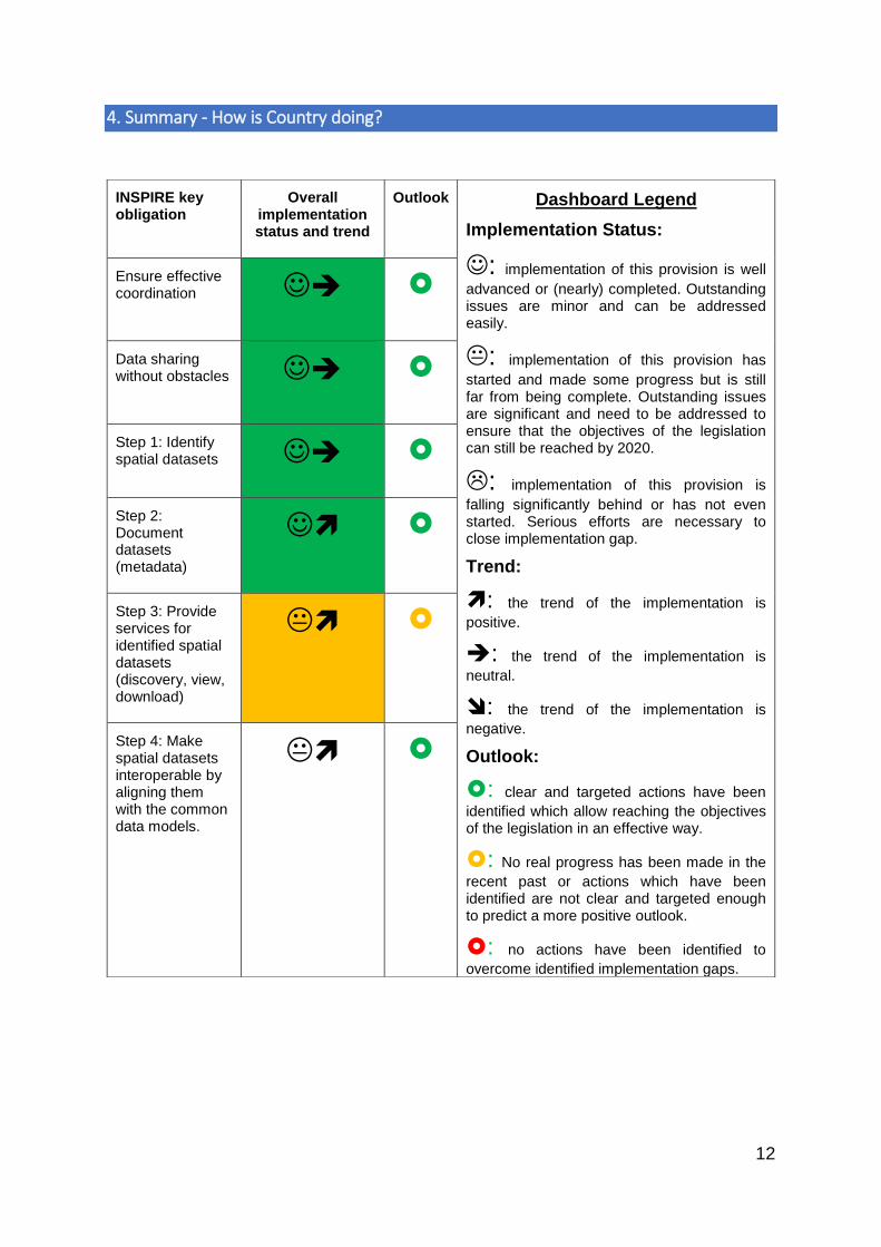
4. Summary - How is Country doing?
INSPIRE key obligation
Overall implementation status and trend
Outlook Dashboard Legend
Implementation Status:
: implementation of this provision is well
advanced or (nearly) completed. Outstanding issues are minor and can be addressed easily.
: implementation of this provision has
started and made some progress but is still far from being complete. Outstanding issues are significant and need to be addressed to ensure that the objectives of the legislation can still be reached by 2020.
: implementation of this provision is
falling significantly behind or has not even started. Serious efforts are necessary to close implementation gap.
Trend:
: the trend of the implementation is
positive.
: the trend of the implementation is
neutral.
: the trend of the implementation is
negative.
Outlook:
: clear and targeted actions have been
identified which allow reaching the objectives of the legislation in an effective way.
: No real progress has been made in the
recent past or actions which have been identified are not clear and targeted enough to predict a more positive outlook.
: no actions have been identified to
overcome identified implementation gaps.
Ensure effective coordination
Data sharing without obstacles
Step 1: Identify spatial datasets
Step 2: Document datasets (metadata)
Step 3: Provide services for identified spatial datasets (discovery, view, download)
Step 4: Make spatial datasets interoperable by aligning them with the common data models.
13
Specific recommendations:
For each Member State, the accessibility of environmental data (based on what the
INSPIRE Directive envisages) as well as data-sharing policies have been
systematically reviewed.
France has indicated in the 3-yearly INSPIRE implementation report that the
necessary data-sharing policies allowing access and use of spatial data by national
administrations, other Member States' administrations and EU institutions without
procedural obstacles are available and implemented. No fundamental obstacles
have been identified that impede data-sharing between authorities. The coming
years France is likely to adopt an open data policy as part of "Towards a digital
Republic" project that is currently under debate in the French Parliament.
Assessments of monitoring reports issued by France and the spatial information that
France has published on the INSPIRE geoportal indicate that not all spatial
information needed for the evaluation and implementation of EU environmental law
has been made available or is accessible. The larger part of this missing spatial
information consists of the environmental data required to be made available under
the existing reporting and monitoring regulations of EU environmental law.
Suggested action
Identify and document all spatial data sets required for the implementation of
environmental law, and make the data and documentation at least accessible
'as is' to other public authorities and the public through the digital services
foreseen in the INSPIRE Directive.