Embed Size (px)
Citation preview

INITIAL SITE INVESTIGATION WORKPLAN FOR THE NAPA-1 FORMER MANUFACTURED GAS PLANT NAPA, CALIFORNIA
Prepared For:
PACIFIC GAS AND ELECTRIC COMPANY 3401 Crow Canyon Road San Ramon, CA 94583
May 2009 (Revision 002)
Prepared by PARSONS
2121 N. CALIFORNIA BLVD., SUITE 500 • WALNUT CREEK • CALIFORNIA 94596
PG&E Pacific Gas and Electric Company®

PARSONS i ISI WORKPLAN May 2009
INITIAL SITE INVESTIGATION WORKPLAN
NAPA-1 FORMER MANUFACTURED GAS PLANT SITE
201 RIVERSIDE DRIVE NAPA, CALIFORNIA
This Initial Site Investigation (ISI) Workplan was prepared by Parsons for Pacific Gas and Electric Company (PG&E) and is intended for use by PG&E and its contractors during performance of the Initial Site Investigation of the Napa-1 Former Manufactured Gas Plant Site. This Workplan, and interpretations or conclusions presented herein, are based upon limited data that has been collected from the Site and limited data from nearby sites that has been published in documents cited and listed in the references section of this Workplan. This Workplan was prepared in accordance with currently accepted professional practices; no warranty, expressed or implied, is made.
Linda McGlochlin Wolff, PG 6004, CHG Date Project Manager
05/08/09 ____________________________________________________________________ Paul Farmanian Date Program Manager

TABLE OF CONTENTS
PARSONS ii ISI WORKPLAN May 2009
1.0 INTRODUCTION AND SUMMARY............................................................................ 1-1 1.1 INTRODUCTION ........................................................................................................... 1-1 1.2 SUMMARY OF BACKGROUND INFORMATION..................................................... 1-2
1.2.1 Current Site Conditions........................................................................................1-2 1.2.2 Historical MGP Operations..................................................................................1-3
1.3 PUBLIC PARTICIPATION ACTIVITIES ..................................................................... 1-6 1.4 DATA COLLECTION AND EVALUATION................................................................ 1-7 1.5 HUMAN-HEALTH SCREENING EVALUATION..................................................... 1-10 2.0 ISI OBJECTIVES ............................................................................................................ 2-1
3.0 SUMMARY OF BACKGROUND DATA SEARCH..................................................... 3-1 3.1 DATA SEARCH METHODOLOGY.............................................................................. 3-1 3.2 SITE DESCRIPTION AND LOCATION....................................................................... 3-1
3.2.1 Site Name.............................................................................................................3-1 3.2.2 Site Address .........................................................................................................3-2 3.2.3 Designated Contact Person ..................................................................................3-2 3.2.4 Mailing Address...................................................................................................3-2 3.2.5 Telephone Number...............................................................................................3-2 3.2.6 Other Site Names .................................................................................................3-2 3.2.7 U.S. Environmental Protection Agency (USEPA) Identification Number..........3-2 3.2.8 EnviroStor Database Number ..............................................................................3-2 3.2.9 Assessor’s Parcel Number(s) ...............................................................................3-2 3.2.10 Township, Range, Section and Meridian.............................................................3-2 3.2.11 Site Zoning...........................................................................................................3-2 3.2.12 Site Maps and Photographs..................................................................................3-3
3.3 REGULATORY STATUS .............................................................................................. 3-3 3.4 PHYSICAL AND ENVIRONMENTAL CHARACTERISTICS ................................... 3-5
3.4.1 Site Topography...................................................................................................3-5 3.4.2 Site Geology and Soil Types................................................................................3-5 3.4.3 Site Hydrogeologic Setting ..................................................................................3-5 3.4.4 Site Climatological Setting ..................................................................................3-6
3.5 CURRENT AND HISTORICAL LAND USES.............................................................. 3-6 3.5.1 Property Ownership .............................................................................................3-6 3.5.2 Facility Ownership/Operators..............................................................................3-6 3.5.3 Business Type ......................................................................................................3-6 3.5.4 Years of Operation...............................................................................................3-7 3.5.5 Business/Manufacturing Activities......................................................................3-7
3.6 SURROUNDING PROPERTY LAND USES ................................................................ 3-7 3.7 PRIOR INVESTIGATIONS............................................................................................ 3-7
3.7.1 PG&E 1986 and 1987 Investigations...................................................................3-7 3.7.2 USEPA.................................................................................................................3-8 3.7.3 1992 US Army Corps of Engineers Study...........................................................3-8 3.7.4 San Francisco Bay Regional Water Quality Control Board File .........................3-9
4.0 FIELD SAMPLING PLAN ............................................................................................. 4-1 4.1 BACKGROUND ............................................................................................................. 4-1

TABLE OF CONTENTS (Continued)
PARSONS iii ISI WORKPLAN May 2009
4.1.1 Data Quality Objectives Process..........................................................................4-1 4.2 SAMPLING STRATEGY AND APPROACH ............................................................... 4-2
4.2.1 Rationale for Sampling Strategy..........................................................................4-2 4.2.1.1 Overview ............................................................................................... 4-2
4.2.2 Soil, Soil Gas, and Groundwater Sampling Methods and Procedures.................4-4 4.2.2.1 Utility Clearance.................................................................................... 4-4 4.2.2.2 Soil Sampling ........................................................................................ 4-6 4.2.2.3 Soil Gas Sampling ................................................................................. 4-6 4.2.2.4 Groundwater Sampling........................................................................ 4-10 4.2.2.5 Field Instrument Calibration................................................................ 4-11
4.2.3 Sample Analysis.................................................................................................4-12 4.2.3.1 Request for Analyses........................................................................... 4-12 4.2.3.2 Analysis Methods and Detection Limits ............................................. 4-12
4.2.4 Sample Containers and Preservatives ................................................................4-13 4.2.5 Sample Packaging and Shipment.......................................................................4-13 4.2.6 Sample Documentation......................................................................................4-14
4.2.6.1 Field Logbooks.................................................................................... 4-14 4.2.6.2 Boring Logs ......................................................................................... 4-15 4.2.6.3 Chain-of-Custody Records .................................................................. 4-15 4.2.6.4 Photographs ......................................................................................... 4-16
4.2.7 Decontamination Procedures .............................................................................4-16 4.2.8 Investigative Derived Waste Management ........................................................4-16
4.3 QUALITY ASSURANCE AND QUALITY CONTROL MEASURES ...................... 4-17 4.3.1 Evaluation of Analytical Methods .....................................................................4-18 4.3.2 Evaluation of Detection Limits..........................................................................4-18 4.3.3 Evaluation of Qualified Data .............................................................................4-18 4.3.4 Evaluation of Blanks..........................................................................................4-18 4.3.5 Comparison of Site Data with Background Data...............................................4-19 4.3.6 Selection of Chemicals of Potential Concern (COPC) ......................................4-19 4.3.7 Field Variances ..................................................................................................4-19
5.0 HUMAN-HEALTH SCREENING EVALUATION....................................................... 5-1
6.0 ISI REPORT PREPARATION........................................................................................ 6-1
7.0 WORK SCHEDULE ....................................................................................................... 7-1
8.0 REFERENCES ................................................................................................................ 8-1

TABLE OF CONTENTS (Continued)
PARSONS iv ISI WORKPLAN May 2009
LIST OF TABLES PAGE
1 Soil Sampling Locations and Rationale for Proposed Sampling Program Tables-1
2 Soil/Soil Gas/Groundwater Sampling Locations and Analysis Tables-3
3 Application of the Data Quality Objectives (DQO) Process to the Site Tables-6
4 Requirements for Containers, Preservation Techniques, Sample Volumes, and Holding Times Tables-7
LIST OF FIGURES PAGE
1 Site Location Figures-1
2 Current Structures Figures-2
3 Sanborn Figures Figures-3
4 1940 Historic Aerial Photograph Figures-4
5A Proposed ISI Sampling Plan (Map) Figures-5
5B Proposed ISI Sampling Plan (Aerial) Apartment Complex Figures-6
5C Proposed ISI Sampling Plan (Aerial) Riverbank Figures-7
6 Proposed Soil Gas Probe Construction Schematic Diagram Figures-8
LIST OF PHOTOGRAPHS PAGE 1 1890 Photograph 1-4
2 1891 Photograph 1-5
3 1899 Photograph 1-8
4 1910 Photograph 1-9
LIST OF APPENDICES
A Historic Sanborn Fire Insurance Maps
B Aerial Photographs
C EDR Report and Conceptual Chain of Title
C1 EDR Report
C2 Conceptual Chain of Title
D Historical Overview of Napa-1 Former MGP
E Current Photographs of the Site
F Quality Assurance Project Plan
G Project Health and Safety Plan
H En Core® Sampling Procedures

PARSONS v ISI WORKPLAN May 2009
ACRONYMS
ARAR Applicable or Relevant and Appropriate Requirements
ASTM American Society for Testing and Materials
bgs Below Ground Surface
Cal/EPA State of California Environmental Protection Agency
CA UST California Underground Storage Tank Database
CHHSL California Human Health Screening Level
COC Chain of Custody
COPC Chemicals of Potential Concern
DQO Data Quality Objectives
DTSC Department of Toxic Substances Control
EDR Environmental Data Resources, Inc.
ELAP Environmental Laboratory Accreditation Program
EMI Emissions Inventory Data
EnviroStor DTSC EnviroStor Database
eV Electron volt
FID California Facility Inventory Database
FIFRA Federal Insecticide, Fungicide and Rodenticide Act
FINDS Facility Index System/Facility Registry System
FSP Field Sampling Plan
FTTS FIFRA and TSCA Tracking System
GPR Ground Penetrating Radar
GZA GZA Geoenvironmental Inc.
HAZNET Hazards Network Database
HIST UST State Hazardous Substance Storage Container Database
HRA Human-Health Risk Assessment
HSE Human-Health Screening Evaluation
IDW Investigation Derived Waste
ISI Initial Site Investigation

PARSONS vi ISI WORKPLAN May 2009
ACRONYMS
LUST Leaking Underground Storage Tank (database)
MiniRAE Rae Systems Inc. MiniRAE
mg/kg Milligrams per kilogram
MGP Manufactured Gas Plant
mg/l Milligrams per liter
MTBE Methy tertiary butyl ether
NCP National Contingency Plan
NPL National Priorities List
OERR Office of Emergency and Remedial Response
PAH Polycyclic Aromatic Hydrocarbons
PA/SI Preliminary Assessment/Site Investigation
PID Photoionization Detector
PG&E Pacific Gas and Electric Company
ppb Parts per billion
PPE Personal Protective Equipment
ppm Parts per million ppmv Parts per million by volume
PPP Public Participation Plan
PTFE Polytetrafluoroethylene
QAPP Quality Assurance Project Plan
QA/QC Quality Assurance/Quality Control
RAGS Risk Assessment Guidance for Superfund
RCRIS Resource Conservation and Recovery Information System (database)
RI Remedial Investigation
RI/FS Remedial Investigation/Feasibility Study
RWQCB Regional Water Quality Control Board
SLIC Spills, Leaks, Investigation and Cleanup (database)
SQG Small Quantity Generator
SWEEPS UST
Statewide Environmental Evaluation and Planning System Database
TPH Total Petroleum Hydrocarbons

PARSONS vii ISI WORKPLAN May 2009
ACRONYMS
TSCA Toxic Substances Control Act
ug/l Micrograms per liter
USA Underground Services Alert
USCS Unified Soil Classification System
USEPA United States Environmental Protection Agency
USGS United States Geological Survey
UST Underground Storage Tank
VMP Vapor Monitoring Point
VOC Volatile Organic Compound

PARSONS 1-1 ISI WORKPLAN May 2009
1.0 INTRODUCTION AND SUMMARY
1.1 INTRODUCTION
This document presents an Initial Site Investigation (ISI) Workplan (Workplan) for the Napa-1 Former Manufactured Gas Plant (MGP) Site located at 201 Riverside Drive, Napa, Napa County, California. The Napa-1 Former MGP was located on two parcels on the corner of Riverside Drive and Elm Street, adjacent to the Napa River. Riverside Drive (formerly Cross Street) runs north-south along the western levee of the Napa River.
The Napa-1 MGP was acquired by Pacific Gas and Electric Company (PG&E) from the Napa Gas and Electric Company. The two parcels containing the MGP were acquired by PG&E in 1908 and an adjacent third parcel was acquired by PG&E in 1914. The footprint of these parcels (totaling 1.33 acres) is herein referred to as “the Site.” In 1924, the MGP was shut down, and by 1927, the MGP infrastructure had been substantially removed with the last above ground tank removed around 1940. PG&E sold the parcels in 1961 and, in 1963, five residential apartment buildings were constructed at the Site. The Site is still operated as a commercial apartment complex, known as the Riverside Apartments.
This document was prepared by Parsons, on behalf of PG&E, to comply with the substantive requirements of the State of California Environmental Protection Agency (Cal/EPA), Department of Toxic Substances Control (DTSC) for investigating sites with potential soil and groundwater contamination. This Workplan follows a similar format that Parsons has successfully used for investigating other MGP sites in the state of California. The Workplan is intended for use by Parsons and its subcontractors who will be implementing the ISI on behalf of PG&E.
This Workplan has been prepared to ascertain the location and presence of potential MGP related impacts at the Site and to conduct a human health screening evaluation to assist in development of proactive remedial planning strategies. In the past, only limited soil investigations have been performed at the Site (PG&E in 1986 and 1987, and Kleinfelder in 1992). Therefore, the initial soil, soil gas, and groundwater sampling investigation presented herein is proposed for the purpose of determining if MGP constituents exist at levels that warrant the implementation of interim remedial measures and whether Chemicals of Concern (COCs) in groundwater, from offsite sources, are potentially impacting groundwater beneath the Napa-1 Former MGP Site.
PG&E plans to enter into a Voluntary Cleanup Agreement (VCA) with the DTSC once it obtains an Access Agreement with the current property owners. PG&E anticipates working with the DTSC on developing a Remedial Investigation (RI) plan to further evaluate the type and extent of contamination at the site, if any. This future RI will include a formal health risk assessment to evaluate whether Site conditions would require remediation to achieve unrestricted future land use.
For this initial investigation, the Workplan is organized as follows:

PARSONS 1-2 ISI WORKPLAN May 2009
• Section 1.0 – Introduction and Summary presents an introduction and summary of Site background information, and planned field sampling and data collection activities.
• Section 2.0 – ISI Objectives presents the overall objectives of the ISI process.
• Section 3.0 – Summary of Background Research presents a detailed discussion of Site background research.
• Section 4.0 – The Field Sampling Plan (FSP) presents a detailed discussion of planned field and laboratory data collection activities that will be conducted to evaluate environmental conditions at the Site.
• Section 5.0 – The Human-Health Screening Evaluation (HSE) briefly describes the process by which the HSE will be conducted for the Site.
• Section 6.0 – ISI Report Preparation presents the proposed information to be reported to PG&E from the implementation of the ISI.
• Section 7.0 – Proposed Work Schedule presents the estimated work schedule for the implementation of the ISI activities and follow-on activities based on available information at the time of the preparation of this Workplan.
• Section 8.0 – References presents a listing of the documents and information used in preparation of this report.
In addition to sections described above, tables and figures have been provided to assist the reader with visualizing the investigation objectives. Finally, the appendices for this report include the following: Appendix A – Historic Sanborn Fire Insurance Maps provides documentation of historic Site maps with locations of Former MGP assets; Appendix B – Aerial Photographs provides historic aerial photos of the Site; Appendix C – Environmental Data Resources, Inc. (EDR) Database Report provides the environmental database records report for the Site, dated December 12, 2006; Appendix D - Historical Overview of Napa-1 Former MGP provides background information for the Site; Appendix E –Current Photographs of the Site provides recent aerial photos of the Site from Riverside Drive and Elm Street; Appendix F – Quality Assurance Project Plan documents procedures by which the ISI will be implemented; Appendix G – Project Health and Safety Plan provides the documentation on how the work at the Site will be conducted in a safe manner; and Appendix H – En Core Sampling Procedures provides details on collecting soil samples that may contain volatile organic compounds.
1.2 SUMMARY OF BACKGROUND INFORMATION
1.2.1 Current Site Conditions
The Site is located at 201-205 Riverside Drive, in Napa, California (Figure 1). The Site, which formerly consisted of three parcels has undergone lot line adjustments and is now two parcels (Figure 2). Combined, these two parcels occupy approximately 1.33 acres; 0.78-acre for the southern parcel and 0.33-acre for the northern parcel. The Site is located on the northwest corner of Riverside Drive and Elm Street, in an older residential neighborhood of Napa. The Site is bounded by high-density residential units to the north, single-family dwellings to the west, Elm Street to the south, and Riverside Drive to the east. To the south, across Elm Street, is an area of

PARSONS 1-3 ISI WORKPLAN May 2009
mixed residential and light commercial/industrial including the Napa Valley Yacht Club. To the east, across Riverside Drive, is the western levee of the Napa River.
Current Site improvements include the following: Five, two-story wood frame residential apartment buildings, which are divided into 40 two bedroom, one bath apartment units; two carports along the western perimeter of the Site; two smaller single story buildings for laundry and pool equipment, one located along the eastern perimeter of the property and the other in the center of the northern half of the property; and a swimming pool also located on the eastern side of the property (Figure 2). Aerial photographs and county assessor records indicate the apartment complex was constructed in 1963. Since its construction, the only apparent modifications to the apartment complex (as determined from review of aerial photographs) have been the filling-in of one of two swimming pools, and the remodeling of laundry/pool equipment storage buildings.
1.2.2 Historical MGP Operations
The Napa-1 Former MGP operated from 1889 to 1924 and was considered a revolutionary technology at that time. Coal and oil were stored on Site, converted to gas, and then piped to homes for cooking and heating as well as supplying gas to street lamps in downtown Napa.
Historical records (PG&E, 1987b), Sanborn Maps (see summary of Sanborn Maps in Figure 3), and aerial photographs provide a timeline that summarizes MGP activities and subsequent land use at the Site as follows:
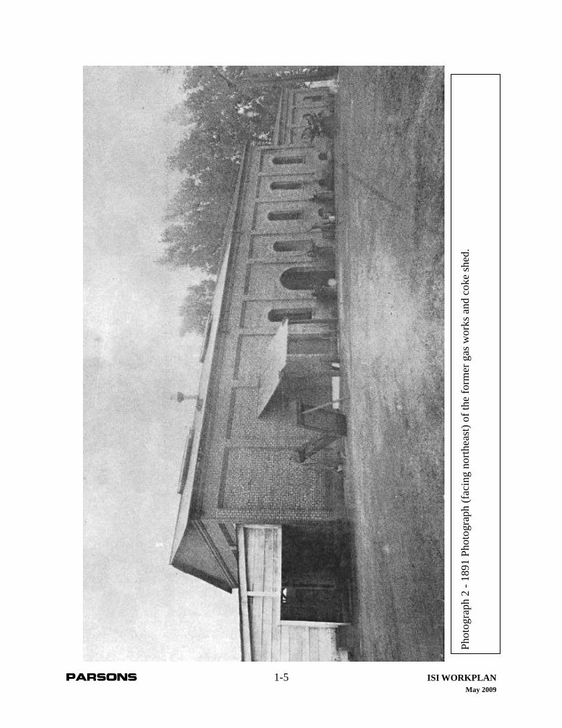
1889- MGP is constructed at the intersection of Elm St. & Cross St. (now Riverside Dr.). The MGP uses the coal gasification process whereby coal is shipped up the Napa River via boat and off-loaded to the MGP via an overhead tramway from the west bank of the Napa River to the coal shed on the north side of the Site. Photograph 1 (page 1-4) shows the tramway from the river to coal shed, which is located behind the MGP gas works. A byproduct of the coal gasification process is coke. Photograph 2 (page 1-5) shows the MGP gas works brick building with the wooden Coke Shed on the left side of the photo with coke drying racks in front of the building.
1901- A forge is constructed along the western property boundary.
1902- The Former Napa-1 MGP is converted from coal to the Lowe Oil Process. This conversion is reflected in later Sanborn Maps (1901 to 1910) which show the removal of the coal and coke sheds and the addition of underground oil tanks south of the gas works building.
1910-1924- MGP continues gradual expansion with additional aboveground storage tanks added.
June 1924- Natural gas arrives from the city of Vallejo; the MGP is shut down.
1927- MGP facilities largely removed.
1940-1945 - Last aboveground tank is removed.
1961- PG&E sells property.
1963- Current apartment complex constructed on the property.

PARSONS 1-4 ISI WORKPLAN May 2009
Phot
ogra
ph 1
- 18
90 P
hoto
grap
h (f
acin
g no
rth) o
f the
form
er g
as w
orks
and
coa
l tra
mw
ay e
xten
ding
to th
e N
apa
Riv
er (t
o th
e w
est j
ust o
ut o
f the
fram
e).
PARSONS 1-5 ISI WORKPLAN May 2009
Phot
ogra
ph 2
- 18
91 P
hoto
grap
h (f
acin
g no
rthea
st) o
f the
form
er g
as w
orks
and
cok
e sh
ed.
PARSONS 1-6 ISI WORKPLAN May 2009
During the operational life of the Napa-1 Former MGP, there were three main configurations of facilities at the Site. Prior to 1902, when the MGP utilized coal for gas production, facilities at the MGP consisted of the brick building containing the gas works (including office, workshop, storage, purifier, scrubber, condenser, pump, tar tanks, and retorts). The Site also contained a a 20,000 cubic foot capacity gas holder, a coal shed with tramway extending to the Napa River, and a coke shed (see Photograph 3 on page 1-8). The second configuration, after conversion to the Lowe Oil Process, included the addition of a second, larger gas holder 40 feet in diameter, three oil tanks (one underground and two aboveground), a forge, and support buildings, as well as the removal of the coal and coke sheds, which were no longer necessary (see Photograph 4 on page 1-9). In 1924, the gas plant ceased operations when the natural gas pipeline from the city of Vallejo reached Napa.
Historical records of the MGP indicated that gas production results were good and that the facility was kept in a clean condition. In the PG&E historical overview of the Former Napa-1 MGP (PG&E 1987b), a well-known gas engineer, Mr. E.C. Jones, paid tribute to the gas plant as follows:
“…Coupled with mechanical excellence was the highest degree of cleanliness possible in a gas works. About the buildings, the grounds were laid out in gardens of roses and cannas, and round the gasholder tank were beds of calla lilies, while at the back of the garden were trellises completely embowered with purple wisteria. Everywhere, inside and outside the works, was evident the touch of Parker’s knowledge and good taste.” (E.C. Jones, “History of Napa and its Gas Business,” In Pacific Gas and Electric Company, Historical and Descriptive, Vol. 1, p.298-299).
By 1927, the Napa-1 Former MGP was largely dismantled including the second gas storage tank, one oil tank, and ancillary Site buildings. The property remained unused until 1961, when PG&E sold the property. However, not all the MGP infrastructure was removed in 1927 since the 1940 aerial photograph shows that either an aboveground tank or aboveground tank foundation was still present on the property (Figure 4). However, in the 1945 Sanborn map and 1958 aerial, the aboveground tank (or tank pad) is no longer evident. In 1960, an aerial photograph shows the Site as vacant, which is consistent with Sanborn documentation that shows the Site as vacant when the property was sold by PG&E in 1961. Detailed documentation of MGP infrastructure is presented in historic Sanborn Fire Insurance Maps (Appendix A) and post 1940 land use at the Site is documented in historical aerial photographs (Appendix B).
1.3 PUBLIC PARTICIPATION ACTIVITIES
No public participation activities are planned for the initial investigation at the Site, however, a community survey will be prepared and submitted to the DTSC for review, comment, and approval following initiation of the VCA and subsequent RI requirements. Upon approval, the community survey would be distributed prior to the implementation of the RI. Additionally, during the RI a Public Participation Plan (PPP) will be prepared if results from the community survey warrant the preparation of a PPP. A DTSC-approved Work Notice would then be issued to all individuals on the Site-specific radius and key contact mailing lists five working days or one-week prior to the start of RI field work.

PARSONS 1-7 ISI WORKPLAN May 2009
1.4 DATA COLLECTION AND EVALUATION
The ISI sampling and analysis program will be conducted to ascertain the location and presence of potential MGP-related impacts at the Site. The scope of field investigation and laboratory analytical testing is described in the FSP presented in Section 4.0. The goal of the FSP is to determine the presence (or absence) of typical MGP constituents such as polycyclic aromatic hydrocarbons (PAHs), total petroleum hydrocarbons (TPH), and heavy metals associated with Former MGP Site in areas that are currently readily accessible. A total of 49 sample locations (12 soil boring/soil gas locations, 9 soil-boring only locations, and 28 surficial sample locations) will be investigated (Figures 5A, 5B, and 5C). Soil boring logs with lithologic descriptions will be prepared for each soil boring location.
Soil matrix samples will be obtained from each of the 21 soil boring locations at depths of, 2, 4, 6, and 8 feet below ground surface (bgs) with the deepest sample depth adjusted to be near the termination of boring, just above groundwater.
For the 28 surficial sampling locations, 10 will be located within unpaved areas of the apartment complex and the remaining 18 will be located along the western bank of the Napa River, in areas of suspected MGP impacts. Within the apartment complex, two soil samples will be collected at each of the 10 locations; one between 0 and 6-inches bgs and one between 12-inches and 18-inches bgs, with depths adjusted to avoid surface obstructions. Along the riverbank, 18 samples will be collected based on observations of potential MGP impacts in the riverbank.
Currently no groundwater data is available for the Site; however, groundwater at a neighboring property (1/8 of a mile southwest of the Site) has been documented to range from 3 to 8 feet bgs with a median of approximately 7 feet bgs. If the depth to groundwater is greater than anticipated, or the samples collected at 8 feet bgs are impacted with chemical constituents (as determined by field observations including staining or headspace analysis), a deeper soil sample may also be collected. If the depth to groundwater is shallower than anticipated, then a grab groundwater sample will be collected, but no deeper soil samples will be collected for the saturated zone. Ideally, nine grab groundwater samples will be collected from nine different soil borings; six along the perimeter of the Site and three near the former MGP infrastructure.
Collected soil samples will be analyzed by an accredited laboratory for PAHs, TPH, California Title 22 Metals, volatile organic compounds (VOCs), and cyanide.
The rationale for the proposed sampling program including the biased soil borings is presented in Table 1 and further outlined in Section 4.0, the Field Sampling Plan. Sample depths and analytical parameters for soil, soil gas, and water samples are presented on Table 2. Placement of the soil borings will be such that each of the five apartment buildings has at least two soil borings [each with a two-probe nested vapor monitoring point (VMP)] along the perimeter of the apartment building. For the apartment buildings that partially occupy the former footprint of the

PARSONS 1-8 ISI WORKPLAN May 2009
Phot
ogra
ph 3
- 18
99 P
hoto
grap
h (f
acin
g ea
st) o
f the
form
er n
atur
al g
as h
oldi
ng ta
nk.

PARSONS 1-9 ISI WORKPLAN May 2009
Phot
ogra
ph 4
- 1
910
Phot
ogra
ph (
faci
ng w
est)
of th
e fo
rmer
man
ufac
ture
d ga
s pl
ant i
nclu
ding
a c
rude
sto
rage
tank
(le
ft) tw
o na
tura
l gas
hol
ding
tank
s(ce
nter
), an
d m
ain
build
ing
(rig
ht).

PARSONS 1-10 ISI WORKPLAN May 2009
MGP gas works (Apartment Buildings #3 and #4)1, there will be three and four, respectively, soil borings with nested VMPs placed along the exterior of these apartment buildings. For the remaining soil borings, these will not contain nested VMPs, but rather, these soil borings will be placed at “biased” locations or located along the perimeter of the site where a grab groundwater sample will be collected. Biased meaning where there may be MGP impacts in soil because of proximity to Former MGP infrastructure (e.g. pits, underground oil tanks, coke drying areas, etc.) as identified on Sanborn Maps.
For the 10 surficial soil-sampling locations at the apartment complex, all of these will be located in unpaved areas (e.g. landscaped areas or lawn areas) where residents of the apartment complex may have an exposure pathway to potentially impacted soil. Moreover, only readily accessible portions of the Site will be sampled during the ISI. Samples will not be collected in the interiors of buildings.
Along the riverbank, 12 samples will be collected based on observations of potential MGP residues. An additional 6 surficial soil samples will be collected based upon field observations during the course of the investigation.
As a note, a select number of soil samples will be analyzed for VOCs to meet the data needs for the HSE. Samples for VOC analysis will be collected based on elevated photoionization detector (PID) readings (headspace measurements) and visual and olfactory indications. The locations of these samples will be determined in the field. Laboratory data obtained will be subjected to data validation to ensure that data quality objectives (DQOs) (Table 3) are met and the data are suitable for use in the HSE.
1.5 HUMAN-HEALTH SCREENING EVALUATION
A screening-level health risk evaluation will be prepared following the completion of the ISI in order to assess whether Site conditions warrant the implementation of interim remedial measures. The approach to the screening level health risk evaluation and the range of interim remedial measures that may be appropriate for the Site are discussed below in Section 5.0. If data collected as part of the ISI indicate that interim remedial measures are warranted, PG&E will work expeditiously and in close coordination with DTSC, the present property owners, and the occupants to implement a plan that limits potential exposure to occupants.
1 For discussion purposes, Parsons has assigned numbers (1 through 5) to identify the different on-site apartment buildings. On the Figures and Tables, the northernmost apartment building has been identified as #1, the north apartment building has been identified as #2, the central apartment building has been identified as #3, the western apartment building has been identified as #4, and the southernmost apartment building has been identified at #5. These numbers do not represent actual street addresses for these apartment buildings.

PARSONS 2-1 ISI WORKPLAN May 2009
2.0 ISI OBJECTIVES
The overall objectives of this ISI are as follows:
• Perform an ISI to determine possible chemical impacts to soil, soil gas, and groundwater that may be related to previous MGP operations at the Site.
• Determine whether Chemicals of Concern (COCs) in groundwater, from offsite sources, are potentially impacting groundwater beneath the Napa-1 Former MGP Site.
• Provide sufficient analytical data to support a HSE that will determine if there is an immediate health threat to human health and the environment
• Provide sufficient analytical data for incorporation into the RI.
• Provide recommendations on future investigative methods to characterize the nature and extent of potentially existing MGP related impacts
• Determine the likely impact of investigation activities on occupants of the apartment complex as well as adjacent residential properties and public utilization of the riverbank.

PARSONS 3-1 ISI WORKPLAN May 2009
3.0 SUMMARY OF BACKGROUND DATA SEARCH
3.1 DATA SEARCH METHODOLOGY
Numerous attempts were made to gather historical information as part of the background data search for development of this Workplan; however, only very limited information on the Site was available. No copies of historic reports/documents pertaining to the operation of the Napa-1 Former MGP were located other than what was provided by PG&E. As part of the record search, aerial photographs, Sanborn maps, and historical photographs were reviewed to develop an understanding of current and past land uses and practices that may have involved the handling, use, storage, and/or disposal of hazardous substances or wastes. Because information regarding Site-specific waste handling and/or disposal practices at the Napa-1 Former MGP was not available, the record search focused on information regarding the past location of MGP infrastructure components, whereby these components could be possible sources of chemical residues that might be detected in soil, soil gas and groundwater at the Site.
The approach to the background data search is similar to that used in completing a Phase I Environmental Site Assessment under the American Society for Testing and Materials (ASTM) Practice for Environmental Site Assessments: Phase I Assessment Process (ASTM Standard E 1527-05). Specific sources of information that were reviewed for this Site included:
• Current U.S. Geological Survey (USGS) 7½-minute topographic maps;
• Geologic and hydrogeologic maps;
• Available Sanborn fire insurance maps;
• Available aerial photographs;
• Available historical photographs;
• Environmental database list searches per EDR including Geotracker and the DTSC EnviroStor Database (EnviroStor);
• Reports of prior investigations and remedial activities performed at the Site and adjacent properties; and
• Information provided by Pacific Gas and Electric Company (e.g. historic documents).
For reference, copies of useful historic information have been included as appendices in this Workplan. Appendix A contains copies of Historic Sanborn Fire Insurance Maps. Appendix B contains copies of Aerial Photographs. Appendix C contains a copy of the EDR Database Report. Appendix D contains a copy of the Historical Overview of Napa-1 Former MGP.
3.2 SITE DESCRIPTION AND LOCATION
3.2.1 Site Name
The Site is one of three former MGP sites in Napa, California. It is identified by PG&E as the Napa-1 Former MGP.

PARSONS 3-2 ISI WORKPLAN May 2009
3.2.2 Site Address
The Site address is 201 Riverside Drive, Napa, California and is located at the intersection of Riverside Drive and Elm Street.
3.2.3 Designated Contact Person
Ms. Sharron Reackhof, Senior Project Manager for PG&E’s Environmental Remediation Group.
3.2.4 Mailing Address
The mailing address for the PG&E Project Manager is:
Ms. Sharron Reackhof 3401 Crow Canyon Road, Mail Code 177D San Ramon, CA 94583
3.2.5 Telephone Number
The telephone number for Ms. Reackhof is (925) 415-6326.
3.2.6 Other Site Names
The Site is also referred to as RR-VN-NAP-1 in some historical documents. In some earlier assessor parcel maps, Riverside Drive is referred to as Cross Street and on other documents as the Levee.
3.2.7 U.S. Environmental Protection Agency (USEPA) Identification Number
USEPA Identification Number for the Site is CAD981416019.
3.2.8 EnviroStor Database Number
The EnviroStor number for the Site is 28490007.
3.2.9 Assessor’s Parcel Number(s)
The assessor’s parcel numbers for the Site are 005-123-006-000 and 005-123-011-000.
3.2.10 Township, Range, Section and Meridian
The Site is located within Section 10, Township 5 North, Range 4 West, Mount Diablo Meridian.
3.2.11 Site Zoning
The Site is currently located in an area zoned as MFR – Multiple Family Residential. The Site is surrounded by varied uses, which include traditional residential, public serving and mixed use designations.

PARSONS 3-3 ISI WORKPLAN May 2009
According to the City of Napa Public Works Department, the Site is located in flood zone AE, which indicates areas within the 100-year flood plain. Panel Number 060207-0010C, dated March 16, 1988
3.2.12 Site Maps and Photographs
A vicinity map depicting the Site and surrounding area is included as Figure 1, and a Site layout map is included as Figure 2. Historic Sanborn Fire Insurance Maps and Aerial Photographs are included in Appendices A and B, respectively. Historic photographs of the Site are included in Section 1 of this Workplan.
3.3 REGULATORY STATUS
A review of selected regulatory agency databases for documented environmental concerns on the Site, or in close proximity to the Site, was conducted by EDR (refer to Appendix C for a copy of the EDR Radius Map Report dated December 12, 2006).
EDR reviewed records/databases available from multiple regulatory agencies to determine the current environmental status of facilities within a ¼ to 1 mile radius of the Site. A summary of the records/databases reviewed by EDR is included with a facility description in the EDR report (Appendix C).
There are eight sites that were identified by EDR and Parsons record research in close proximity (< ¼ mile) to, or up gradient (north) of the Site. The location of these sites is shown on the map in the EDR report (Appendix E EDR detail map-1815422.2s, page 14). The following are descriptions of these sites with the EDR identification number in parenthesis.
< 1/8 Mile from the Site
• Krainert Air Conditioning (3) is located at 162 Coombs Street, and to the southwest of the Site. This facility is recorded in the California Leaking Underground Storage Tank Database (LUST), which contains an inventory of reported leaking underground storage tank incidents. The database reports a gasoline discharge from a leaking underground storage tank (UST). The database reports that the case was closed July 20, 1993. Based on the location (downgradient), regulatory status, and contaminants of concern (gasoline) this facility has a low potential to have impacted the Site.
• Super 7 Store # 18914 (A4 and A5) is located at 291 Coombs Street, and to the northwest of the Site. This facility is recorded in the LUST, which contains an inventory of reported leaking underground storage tank incidents. The database reports a gasoline discharge from a leaking UST. The database reports that the case was closed July 1, 1998. Based on regulatory status, and contaminants of concern [gasoline and methyl tertiary butyl ether (MTBE)], this facility has a low potential to have impacted the Site.
< 1/4 mile from the Site
• Lixit Corporation (B6) is located at 100 Coombs Street, and to the southwest of the Site. This facility is recorded in the Spills, Leaks, Investigations, and Cleanup (SLIC)

PARSONS 3-4 ISI WORKPLAN May 2009
Database. The database reports onsite groundwater contains contaminants (chromium and VOCs). An offsite responsible party (B9) has been identified for chromium. The status of the case is currently open; however, the most recent regulatory correspondence (July 15, 2005) stated a no further action letter was pending upon completion of the cap onsite. Based on the regulatory status and groundwater gradient, the potential for this facility to have impacted the Site is low.
• CRU (B7) is located at 100 Coombs Street, and to the southwest of the Site. The Federal Resource Conservation and Recovery Information System (RCRIS) and the Facility Index System/Facility Registry System (FINDs) databases identify this Site as a small quantity generator (SQG). No releases have been documented. Based on the regulatory status, the potential for this facility to have impacted the Site is low.
• Circle K Store #1498 (B8) is located at 75 Coombs Street, and to the southwest of the Site. This facility is recorded in several databases. RCRIS and FINDs databases identify this Site as a SQG. This facility is recorded in the Hazards Network (HAZNET) database as a generator of oil containing wastes. LUST, DTSC’s Hazardous Waste and Substances Site Database (CORTESE), California Underground Storage Tank Database (CA UST), California Facility Inventory Database (FID), State Hazardous Substance Storage Container Database(HIST UST), and Statewide Environmental Evaluation and Planning System (SWEEPS UST) databases report gasoline and a solvent discharge from a leaking UST. The database reports that the case was closed March 6, 2003. Based on the regulatory status, the potential for this facility to have impacted the Site is low.
• Sawyer of Napa Inc. (B9) is located at 68 Coombs Street, and southwest of the Site. This facility is recorded in several databases. The RCRIS and FINDs databases identify this Site as a SQG. A release is recorded July 6, 1972 and a violation recorded on March 17, 1986. The Site is listed on LUST, CA UST, FID, HIST UST, SWEEPS UST, and CORTESE, for a leaking underground storage tank; this case is listed as closed. This facility is recorded in the HAZNET database as generating pesticides, or was associated with pesticide production, asbestos containing materials, and contaminated soil. Emissions Inventory Data (EMI) lists the Site as a carbon monoxide generator for the San Francisco Bay Region. EnviroStor and SLIC databases list chromium and lead as chemicals of concern onsite. This case is currently listed as open by San Francisco Bay Regional Water Quality Control Board (RWQCB). Based on the regulatory status and the proximity to the Site, the potential for this facility to have impacted the Site is moderate.
• West Napa Pump Station (11) is located on Coombs Street, southwest of the Site. This facility is recorded in the HIST UST database for having a diesel UST. Based on the regulatory status and the proximity to the Site, the potential for this facility to have impacted the Site is low.
• Calnap Tanning Company (C12, C13, and C14) is located at 101 Coombs Street, southwest of the Site. The RCRIS and FINDs databases identify this Site as a SQG. This facility is recorded in the LUST, CA UST, FID, HIST UST, SWEEPS UST, Federal Insecticide, Fungicide and Rodenticide Act (FIFRA) and Toxic Substances Control Act (TSCA) Tracking System (FTTS), SLIC, CORTESE, and EnviroStor databases. These

PARSONS 3-5 ISI WORKPLAN May 2009
databases report that the case was closed March 13, 2003. Based on the regulatory status the potential for this facility to have impacted the Site is low.
The orphan summary was reviewed. The recorded facilities do not appear to be located within the specified search radii.
3.4 PHYSICAL AND ENVIRONMENTAL CHARACTERISTICS
3.4.1 Site Topography
The Site is located adjacent to the Napa River. The Site topography is relatively flat. Ground surface elevations are approximately 10 feet above sea level.
3.4.2 Site Geology and Soil Types
The City of Napa is situated in the south central portion of the Napa Valley. The Napa Valley is a northwest-southeast trending syncline that is bounded by the Mayacamas Mountains on the west and the Howell Mountains on the east. Basement rocks (Jurassic-Cretaceous), are the oldest rocks and consist of the Franciscan Complex which include sandstone and lesser amounts of shale, chert, limestone, and conglomerate. The Franciscan Complex rocks are exposed primarily on the Mayacamas Mountains on the west side of the valley. Overlying the Franciscan complex is the Great Valley Sequence (Cretaceous), which consists of sandstone, shale, and conglomerate. The Sonoma Volcanics (Plio-Pleistocene) are pyroclastic flows including andesite, basalt, and rhyolite and are exposed on the eastern side of the valley in the mountain slopes (Pearce et. al., 2002). These older rock formations are typically non-water bearing.
The center of the Napa Valley is largely Quaternary alluvium (early Pleistocene to Holocene) that was deposited by the Napa River and its tributaries. These deposits include unconsolidated alluvial fan and streambed deposits with poorly sorted layers of clay and silt with interbedded discontinuous deposits of sands and gravel.
3.4.3 Site Hydrogeologic Setting
The Napa River is the primary watercourse in the Napa Valley. The river originates in northwestern part of the Napa Valley near the town of Calistoga and flows southeasterly towards the City of Napa. Further south, the Napa River empties into the San Francisco Bay near the City of Vallejo. The City of Napa is built on the alluvial deposits of the Napa River and much of the city is within the Napa River floodplain where in recent years, flooding has caused problems in the downtown area. Near the downtown areas of Napa, the river is tidally influenced and fluctuates several feet on a daily basis leaving mud flats exposed near the riverbanks.
The Napa River is the closest surface water body to the Site and, is located approximately 80-100 feet east of the Site. At the Site, soils are likely alluvial deposits from the Napa River consisting of clays, silty clays, and sandy gravels. Based on results of soils investigation of nearby sites, it is anticipated that the depth to groundwater at the Site is approximately seven feet bgs. The hydraulic gradient appears to move in a southwesterly direction, but likely varies if it is in hydraulic connection with the Napa River.

PARSONS 3-6 ISI WORKPLAN May 2009
Surface drainage at the Site is currently unknown but is most likely to follow topographic controls and run offsite towards the east and southeasterly directions in the direction of the Napa River. Perched groundwater is also likely to be encountered at the Site, particularly during the winter months following rainy periods.
3.4.4 Site Climatological Setting
The Site vicinity is located in an area of relatively equal seasonal temperatures with moderate amounts of precipitation. Temperature in the Site vicinity ranges from an approximate average of 61o Fahrenheit in the winter to an approximate average of 92o Fahrenheit in the summer. The average annual precipitation, which occurs between October and May, is approximately 23 inches per year (http://www.napanow.com/climate.html Napa station).
3.5 CURRENT AND HISTORICAL LAND USES
3.5.1 Property Ownership
The Site, consisting of two parcels, was purchased by the current property owners in 2004. A conceptualized chain of title showing ownership of the Site parcels from 1890 to 1984 is included in Appendix C with the EDR Report.
3.5.2 Facility Ownership/Operators
The Napa-1 Former MGP was operated on two parcels (parcels B and C on the conceptual chain of title) between 1889 and 1924 by the Napa City Gas Lighting and Heating Company, which became the Napa Gas and Electric Company in 1899 and California Central Gas and Electric Company in 1901, and California Gas and Electric Corporation in 1903.
PG&E purchased the Napa-1 Former MGP in 1903 and operated it until 1924. PG&E also purchased a third parcel (parcel A on the conceptual chain of title) adjacent to the Napa-1 Former MGP plant in 1914. It is believed that this third parcel was purchased to allow for future expansion of the MGP; however, there is no indication in the historical records or on the Sanborn Maps that the MGP ever expanded to the third parcel, located north of the Former Napa-1 MGP Site. Parcels A, B, and C are shown on Figure 2 relative to the current property boundaries.
PG&E sold all three parcels in 1961. By that time, all aboveground MGP infrastructure had been removed. Sometime after 1961, there was a lot line adjustment that rendered the three parcels into two parcels, which is the current configuration of the Site. By 1963, the residential apartment complex was constructed on both parcels and the land use has stayed a residential apartment complex since that time under various owners (see conceptual chain of title in Appendix C)
3.5.3 Business Type
The apartment complex is designated as the Riverside Apartments and is located at 201-251 Riverside Dr, Napa, CA 94559-3905. Site structures include five apartment buildings; each apartment building with eight two-bedroom units for a total of 40 units within the complex. Other structures at the Site are a laundry/pool equipment building, carports, and a pool.

PARSONS 3-7 ISI WORKPLAN May 2009
3.5.4 Years of Operation
The apartment complex was built on the Site in 1963 and has operated as an apartment complex since that year.
3.5.5 Business/Manufacturing Activities
The Site was used exclusively for MGP activities from 1889 to 1924. Historical records indicate a small blacksmith shop also operated on the southern edge of the property, but was later relocated to the property’s western edge during the later years of MGP operation.
3.6 SURROUNDING PROPERTY LAND USES
Current surrounding land use has been observed to be primarily high-density residential. In general, prominent adjoining land uses are as follows:
North: The Site is bounded by high-density residences.
East: The Site is bounded by Riverside Drive and beyond by the Napa River.
South: The Site is bounded by Elm Street to and beyond by high-density residences and light commercial/industrial.
West: The Site is bounded by private residences.
3.7 PRIOR INVESTIGATIONS
Three investigations have been conducted at the Site and one investigation has been conducted adjacent to the former MGP Site.
PG&E conducted two investigations at the Site, one in 1986 and one in 1987. Both investigations consisted of the collection of surface soil samples from within the Site boundary. In addition to the two PG&E soil sampling events, the USEPA contracted Ecology and Environment to prepare an Environmental Site Assessment Report for the former MGP Site.
In addition to the above mentioned investigations, a preliminary assessment/site investigation was conducted by the US Army Corps of Engineers in 1992, and involved the collection of soil samples from soil borings in the road easement along the perimeter of the Site.
The following subsection provides further details regarding these investigations.
3.7.1 PG&E 1986 and 1987 Investigations
On May 8, 1986, PG&E contacted the then owner of the apartment complex and informed the owner of the history of the Site as a former MGP and the potential for soil on the property to potentially contain chemical constituents from the operation of the Former MGP. The owner agreed to let PG&E collect soil samples from the Site and three soil samples were collected from the exposed soil. For these samples, sample results for total PAHs varied from 34 to 1,200 parts per million (ppm), lead varied from 66 to 120 ppm, arsenic from 15 to 35 ppm, mercury from 0.5

PARSONS 3-8 ISI WORKPLAN May 2009
to 1.0 ppm, and cyanide <1.0 ppm (Geotracker, 2008). Only the 1,200 ppm PAH result was considered high. A Site map showing the location where these samples were collected is not available. The soil sample results were shared with the then owner of the property and the San Francisco RWQCB.
To assess the significance of the 1,200 ppm PAH sample, 4 additional samples were collected in the surrounding area by PG&E in early 1987 (PG&E, 1987a). On May 2, 1987, PG&E provides the landowner and regulatory agency notification of the verification sampling results from the Site. Sample results were non-detect to 54 ppm (Geotracker, 2008)
3.7.2 USEPA
In 1989, Ecology and Environment prepared a Site Investigation Summary Report for the USEPA as a part of USEPA’s process for determining whether the Former Napa-1 Former MGP was eligible as Site under the National Priorities List (NPL). Upon review of the available information, Ecology and Environment concluded that the Site does not appear to be eligible for inclusion on the NPL. This recommendation was based on the fact that groundwater in the vicinity of the Site is not used as a source of drinking water, the Napa River is not used as a source of drinking water, and the potential for air release is low. On the basis of these conclusions, the USEPA’s recommendation was for No Further Action at that time.
3.7.3 1992 US Army Corps of Engineers Study
In 1992, The US Army Corps of Engineers hired Kleinfelder to prepare a Preliminary Assessment/Site Inspection (PA/SI) of potential contaminated sites along the Napa River in the City of Napa (Kleinfelder, 1992). The PA/SI was conducted to determine the potential impact of environmental conditions on the Napa River Flood Control Project. At the Former Napa-1 MGP Site, the PA/SI involved the installation of four soil borings in the road easement adjacent to the Site. These borings were identified as NR21-KB1 through NR21-KB4, with two of the borings on Elm Street and two of the borings on Riverside Drive. The map showing the locations of the four soil borings is missing from the copy of the Kleinfelder report.
At boring NR21-KB2, maximum diesel [1,400 milligrams per kilogram (mg/kg)] was detected in soil at 11 feet bgs and maximum oil and grease (2,300 mg/kg) was detected in the same location. Groundwater analyses from NR21-KB2 detected diesel at 140 milligrams per liter (mg/l), oil and grease at 46.5 mg/l, and methylene chloride at 56.8 micrograms per liter (ug/l), although no other VOCs were detected. At NR21-KB4, nickel was detected in groundwater at 147 parts per billion (ppb).
The Kleinfelder report also noted that groundwater was encountered at an approximate depth of 11 to 20 ft bgs, but also noted that water was abundant in roots holes, which suggested a perched groundwater condition. Slight to moderate hydrocarbon odors was noticed on soil samples collected from NR21-KB2 at depths from 2 to 5.5 ft bgs. Very strong hydrocarbon odors were noted in groundwater encountered in NR21-KB2, which had an oily product along root holes and in groundwater. The Kleinfelder report indicated the Site should be evaluated for further soil and groundwater sampling. A copy of the Kleinfelder report was forwarded to the San Francisco

PARSONS 3-9 ISI WORKPLAN May 2009
RWQCB and the Napa County Department of Environmental Management, Hazardous Materials Division.
3.7.4 San Francisco Bay Regional Water Quality Control Board File
The case description from the Geotracker records also indicates that a file review was performed by the San Francisco RWQCB in 2004. The case review found that soil samples collected were not representative of potential Site contamination, but likely adequately represented the potential exposure pathway. Moreover, pollution in groundwater at 11 to 20 ft bgs was not likely to have adverse effects on Site occupants or construction workers and further stated that the Site cannot be closed, but in the current condition of the property, it does not appear that active cleanup needs to be pursued. The San Francisco RWQCB indicated that any future development of the property must take into account the history of the Site as a MGP in the early 20th century.
PARSONS 4-1 ISI WORKPLAN May 2009
4.0 FIELD SAMPLING PLAN
4.1 BACKGROUND
Although the limited Site sampling that has occurred at the Napa-1 Former MGP Site and in the adjacent road easement has not detected significantly elevated levels of chemical constituents, this FSP is structured to investigate potential soil, soil gas, and groundwater contamination that are frequently found at former MGP sites. The FSP is presented in the following subsections.
4.1.1 Data Quality Objectives Process
The USEPA’s DQO process (USEPA, 2000) was used to facilitate design of the proposed sampling approach for the Napa-1 Former MGP Site. The DQO process is a seven-step iterative planning approach used to prepare plans for environmental data collection activities. It provides a systematic approach for defining the criteria that a data collection design should satisfy, including when, where, and how to collect samples or measurements; determination of tolerable decision error rates; and the number of samples or measurements that should be collected. DQOs define the purpose of the data collection effort, clarify what the data should represent to satisfy this purpose, and specify the performance requirements for the quality of information to be obtained from the data (USEPA, 2000).
Although the statistical aspects of the DQO process are important, planning teams may not be able to apply statistics to every hazardous waste Site investigation problem. In some cases, investigators may need to use judgmental sampling or make authoritative measurements to confirm Site characteristics. Given the data gathered during previous sampling events, Site chemicals of potential concern (COPCs), and the nature of supplemental data needed for the ISI, the sampling program presented herein contains elements that are judgmental (biased), where statistical methods could not be used to measure uncertainty.
The following outline summarizes the seven-step DQO process and a brief description of each step:
1. Statement of Problem: Identifies the main issue for the Site that will guide the sampling.
2. Identify the Decision: States the questions that require additional data collection.
3. Identify Inputs to the Decision: Specifies the type of data to be collected such as groundwater samples, soil samples, or geotechnical parameters.
4. Define the Study Boundaries: Delineates the boundaries of the study problem.
5. Develop A Decision Rule: Identifies specific criteria that must be satisfied before the field effort can be considered complete. Describes what would be required if the stated criteria are not met.
6. Specify Limits on Decision Errors: Specifies how the data will be treated statistically and what the acceptable limits of uncertainty are.

PARSONS 4-2 ISI WORKPLAN May 2009
7. Optimize the Design for Obtaining Data: Defines what, if any, measures are being taken to achieve an optimal sampling plan.
Table 3 presents an outline of steps in the DQO process for the Napa-1 Former MGP Site, as described more fully in the following Site-specific sampling approach.
4.2 SAMPLING STRATEGY AND APPROACH
The following sections describe the rationale for this sampling strategy, investigative methods and procedures, sample analysis program, sample handling, decontamination procedures, and management of investigation-derived wastes.
4.2.1 Rationale for Sampling Strategy
4.2.1.1 Overview During this investigation, soil samples will be collected from 21 borings and 28 surficial sample locations from the apartment complex and the adjacent riverbank that are readily accessible to the public and may have MGP impacts to soil. At the apartment complex, 21 soil borings will be advanced with 12 of the 21 soil borings used to collect soil gas samples. Grab groundwater samples will be collected from 9 of the 21 soil borings located along the perimeter of the Site. The proposed locations of the soil/soil gas borings are based on the suspected location of past MGP infrastructure, the footprint of the current apartment buildings, and more generally, a 50’ x 50’ sampling grid. Surficial soil samples will also be collected from 10 locations in unpaved areas within the apartment complex where there is the potential for human contact with surface soil. Along the riverbank, 12 samples will be collected where there were observation of potential MGP impacts and 6 soil samples will be collected at locations based upon field observations during the course of the investigation.
For the apartment complex, the proposed locations of the soil borings, soil borings to be converted to VMPs, and surface soil samples relative to Site structures and former MGP infrastructure are shown in Figure 5A and 5B. For the adjacent riverbank, the proposed locations of the surficial samples are shown on Figures 5A and 5C.
The sampling rationale for each of the sample locations (both at the apartment complex and on the riverbank) is presented in Table 1. Table 2 summarizes the estimated total depth of each boring, the estimated number of samples to be collected from each boring, the estimated depths where soil samples will be collected, and the chemical parameters to be analyzed in samples collected at each boring location. The following subsections provide a description of the sampling strategy for each environmental media.
Soil Sampling Strategy
Apartment Complex
Twelve of the twenty-one soil borings are soil borings that will be converted to nested VMPs. These soil borings will be placed such that there are two or three soil borings with nested VMPs near each apartment building. The remaining borings are at either biased locations and will be located in areas were former MGP infrastructure may have impacted the soil or placed along the

PARSONS 4-3 ISI WORKPLAN May 2009
perimeter of the site for grab groundwater collection. As a note, only readily accessible portions of the apartment complex will be sampled during this investigation. If it is determined that sampling in the street or public right of way is necessary, this work will be performed during a second mobilization after the required permits are obtained from the City and traffic control plans are established. Prior to conducting sampling in the street, an addendum to the Workplan will be submitted to DTSC for review and comment.
At each soil boring location, continuous soil samples will be collected for lithologic description. Discrete soil samples will be collected from depths of 2, 4, 6, and 8 feet bgs with the deepest sample depth adjusted to be near the termination of the boring. For the 10 surficial sampling locations, two soil samples will be collected; one sample between 0 and 6-inches bgs and one sample between 12-inches and 18-inches bgs, with depths adjusted to avoid surface obstructions. In addition, if MGP related impacts (i.e. lampblack, staining, etc.) are encountered, then soil samples will be collected from this layer, and may be collected from unstained soil immediately above and below the impacts. If field evidence (staining or odor) of contamination is encountered during sampling, deeper soil samples will be collected until the vertical extent of impacted soil has been determined or groundwater is encountered. MGP impacts to soil (i.e., lampblack and/or tars) are visually distinctive, typically presented as layers.
A portion of soil from each sampling location will be placed in a sealable bag for headspace measurements. The headspace of each bag will be measured (for volatile organic compounds) using a PID. Prior field experience investigating MGP sites indicates that a headspace PID reading of 100 ppm or higher (calibrated to an isobutylene standard) is an appropriate benchmark. Headspace readings below 100 ppm are frequently attributed to water vapor. If elevated headspace concentrations (100 ppm or greater) are recorded, the soil will also be submitted for VOC analysis.
At this time, it is not anticipated that additional soil boring or surface sample locations will be completed for characterization of the vertical and lateral extent of impacted soil (if impacted soil is discovered). Rather, such characterization will occur during a future remedial investigation. However, during the ISI, if additional soil borings/VMPs are necessary to determine if there is an immediate impact to human health, then the location of additional soil borings/VMPs will be determined during field sampling by physical evidence (staining and/or odor). The collection of additional samples for analysis will be based on visual/olfactory observations and/or PID readings.
Adjacent Riverbank
• Eighteen surficial samples will be collected within 0 to 6 inches of the exposed material surfaces in four general areas along the western bank of the Napa
Soil Gas Sampling Strategy
Biodegradation of petroleum hydrocarbons in the vadose zone can reduce the concentrations of the contaminants in soil gas. Petroleum hydrocarbons are readily degraded by microorganisms to produce increased levels of numerous gases (e.g., carbon dioxide, hydrogen sulfide, methane) while decreasing the concentration of oxygen. The rate of biodegradation is controlled by several

PARSONS 4-4 ISI WORKPLAN May 2009
factors, including soil moisture content, concentration of oxygen, available nutrients in the soils, contaminant type, and soil temperatures.
Sampling for soil vapor affected by biodegradation (e.g., oxygen, carbon dioxide, methane) can provide useful information about the contaminant source area and plume. To determine if biodegradation is taking place in the vadose zone, vertical profiles of the soil gas will be collected and analyzed for VOCs (including BTEX) and naphthalene by USEPA TO-15, and oxygen, methane and carbon dioxide by a field meter.
Nested VMPs with probe depths at 4 feet bgs and 8 feet bgs have been selected to generate the soil gas data necessary to establish the vertical profile of soil gas at the Napa-1 Former MGP Site. Either two or three soil borings completed with nested VMPs will be located near the perimeter of each of the five apartment buildings. There will be a total of 12 nested VMPs The locations of the VMPs is shown on Figure 5A and 5B. A construction diagram for the VMPs is provided in Figure 6.
VMPs are planned in areas where past MGP infrastructure could have impacted the soil, soil gas and groundwater. Consideration has also been given to locating the 12 VMPs within a 50 foot by 50 sampling grid. Although, there is not a VMP within each grid, the establishment of a grid will facilitate the collection of future soil gas data during the future RI investigation, if necessary.
Groundwater Sampling Strategy
Grab groundwater samples will be collected from each of nine soil borings to be advanced at the Site. The soil borings where grab groundwater samples will be collected are shown on Figure 5A and 5B. The grab groundwater samples will be used to provide preliminary evidence, or lack thereof, of the potential impacts in groundwater associated with former MGP operations at the Site and whether Chemicals of Concern (COCs) in groundwater, from offsite sources, are potentially impacting groundwater beneath the Napa-1 Former MGP Site.
If groundwater is greater than 8.5 feet bgs, then the soil boring will be advanced until groundwater is encountered. Due to the unconsolidated fine-grained nature of the soils, as encountered by Kleinfelder in 1992, hand augering to depths of 15 feet should be feasible.
4.2.2 Soil, Soil Gas, and Groundwater Sampling Methods and Procedures
This section describes the methods and procedures that will be used to collect soil samples. All samples will be handled in accordance with the procedures specified in Sections 4.2.4 to 4.2.6. Sample containers and volumes, as well as preservatives and holding times, are presented in Table 4.
4.2.2.1 Utility Clearance
Prior to the commencement of field activities, a number of steps will be taken to identify the locations of active and inactive underground utilities. The initial step will include a field reconnaissance and a review of Site drawings, if available. During the field reconnaissance, boring locations and adjoining areas will be visually inspected for indications of underground

PARSONS 4-5 ISI WORKPLAN May 2009
utilities or other buried structures. Available Site drawings will be examined in the field. Utilities shown on drawings will be marked in the field. At this time, all proposed boring locations will be clearly marked with white paint and/or surveyors flagging.
Geophysical techniques will be used as a second step to identify and map marked and unmarked utility lines and other underground structures. A variety of tools may be used including one or more of the following:
• Ground Penetrating Radar (GPR). GPR provides a continuous real-time measurement of subsurface layering and identification of other features. Each boring location would be investigated with a minimum of two survey lines, each no less than 10 feet long.
• Magnetometer. A magnetometer survey measures variations in the earth’s magnetic field. Variations of the magnetic gradient may identify buried ferrous objects such as pipelines and metallic debris.
• Electromagnetic Utility Locating Instruments. Each identified utility within a radius of 5 feet of proposed boring locations may be investigated using active electromagnetic utility-locating instruments.
• Passive Electromagnetic Receiver. Each boring location may also be investigated by passive electromagnetic receiver to detect possible electrical lines (with voltages up to 30,000 volts). Each suspect signal will be further investigated to locate the source of the signal.
• Conductivity Meter. Each boring location may also be investigated using a shallow focus terrain conductivity meter to identify possible buried and abandoned conduits as well as piping which may have no surface expression.
All utilities identified will be demarcated on the ground using the color code established by the American Public Works Association (red for electric, blue for water, etc.). If a buried utility is found within 5 feet of the boring location, the boring location will be relocated to a more suitable location and necessary procedures repeated. Based on field conditions (amount of interference and quality of data), surveys may be extended to include a grid of the former MGP operational area.
As a third step, Underground Services Alert (USA) will be notified of our intent to conduct subsurface investigations at least 48 hours prior to initiation of intrusive field tasks. USA will contact all utility owners of record within the Site vicinity and notify them of our intention to conduct subsurface investigations in proximity to buried utilities. All utility owners of record, or their designated agents, will be expected to clearly mark the position of their utilities on the ground surface throughout the area of investigation.
As a final safety precaution, all planned soil borings and soil gas locations that have been cleared by geophysical methods will also be advanced to a depth of five feet using a hand auger. This technique would be used if mechanical drilling equipment were planned to complete the soil

PARSONS 4-6 ISI WORKPLAN May 2009
borings, however, for this investigation hand augering is planned for the entire depth of the soil boring.
4.2.2.2 Soil Sampling
In consideration of the noise, accessibility constraints, and safety zone issues and the potential impact to occupants of the apartments units, all planned soil borings and soil gas locations that have been cleared by geophysical methods will be advanced to depth using a hand auger instead of mechanical drilling equipment. Additionally, sample locations may need to be adjusted in the field if proximity to apartment occupants presents a risk.
Upon removal from the subsurface, the soil will be used for lithologic description, and then soil from the desired sample interval will be hand packed into laboratory supplied glass jars and sealed using Teflon lined caps. The sample jars will then be labeled and placed in a sealable plastic bag. If lampblack is encountered, samples of the lampblack will be collected. Unstained soil samples immediately above and below the lampblack may also be collected. The sealed soil samples will be immediately placed into an ice-cooled chest for later possible chemical analyses.
Soil from each sampling location will be reviewed for classification and the possible presence of staining and/or odor. A portion of this sample will also be placed in a sealable bag for headspace measurements. The headspace of each bag will be measured (for volatile organic compounds) using a PID. As discussed above, if elevated headspace concentrations (100 ppm or greater) are recorded, the soil will also be submitted for VOC analysis. Soil descriptions and headspace measurements will be recorded on Parsons’ standard boring log form.
The boring logs will record the following sampling information: boring number and location; sample identification numbers; date and time; sample depth; lithologic description in accordance with the Unified Soils Classification System (USCS); description of any visible evidence of soil contamination (i.e., odor, staining); and organic vapor monitor readings.
Soil samples will also be collected and analyzed for bulk density using ASTM D2937, grain density using ASTM D854, organic carbon content using Walkee-Black Method, soil moisture using ASTM D2216, effective permeability using API RP40, porosity calculated from density, and grain size using ASTM D422, per Section 3.0 of the RWQCB/DTSC guidelines (2003). Three geotechnical samples shall be collected from each soil type identified by the field geologist.
Each soil sample will be named with boring location and the sample depth. The suffix of a soil sample number will indicate the depth in feet from which the sample was collected. For example, sample number H4-1-1 designates a soil sample collected from grid cell designated in column H and row 4, at location 1 within that cell, at a depth of 1 foot.
4.2.2.3 Soil Gas Sampling
A limited soil gas survey will be conducted onsite and soil gas samples will be analyzed for VOCs. Soil gas samples will be collected from 12 two-probe nested locations that are identified by their location number, which corresponds to a 50 foot by 50 foot sampling grid. The soil gas investigation will be conducted by Parsons with a licensed drilling subcontractor performing the

PARSONS 4-7 ISI WORKPLAN May 2009
hand augering. Representatives from Haley and Aldrich and Iris Environmental will provide technical guidance as needed during the investigation.
Varying field conditions such as shallow groundwater, rainfall, fine-grained soils, or drilling refusal may affect the ability to collect soil gas samples. If shallow groundwater is encountered, the soil gas sampling will cease. In addition, soil gas sampling will not be conducted during or immediately after a significant rain event
Soil gas samples will be collected in accordance with the Los Angeles RWQCB 2003 Advisory – Active Soil Gas Investigations and pending modifications to this guidance document. A stainless steel Geoprobe® soil gas sampling implant, or equivalent, connected to ¼-inch teflon tubing will be used for the VMP. The annulus around the implant will be backfilled with sand pack to approximately 12 inches above the top of the VMP. Granular bentonite will be placed above the sand and hydrated with de-ionized water to seal the annulus, which will prevent grout from infiltrating the sand. The sampling port of the VMP will be constructed with a threaded Swagelok stainless steel union and threaded cap, which will allow for sealed equilibration and connection of the sample tubing. The grout will be allowed to cure at least 24 hours prior to leak testing and sampling. This period will also allow subsurface vapors to re-equilibrate following VMP installation. Installation will be documented photographically, and using a field log book.
Each probe will be purged prior to sample collection at a consistent rate between 100 mL/min and 200 mL/min. Each purge volume will be collected in a new Tedlar bag and screened with a PID and O2/CO2 meter and the observations will be recorded. After two consistent readings on the field meters, the soil gas probe has been properly purged. If values on the PID are non-detect, then three purge volumes is the default.
A leak test will be performed at each probe location using Helium as a tracer compound. The tracer compound will be placed around the probe seal at the surface utilizing a shroud to encompass the sampling train. A sample will then be drawn from the probe/tubing in to a new Tedlar bag and tested for the tracer compound with a hand-held Helium detector to ensure that ambient air does not dilute or contaminate the soil gas samples. If leakage is confirmed (>10% of the concentration introduced in to the shroud), the soil gas probe will be properly decommissioned and a replacement probe installed.
Soil Gas Ambient Air Leak Detection Protocol for using Helium
Leak testing procedures will be accomplished as follows:
• Introduce the tracer gas around the sample probe and canister by filling a shroud (such as a plastic bucket) positioned over the sample location.
• Make sure the shroud is suitably sealed to the ground surface.
• Introduce the tracer gas into the shroud. Helium should be injected into the shroud at 5 psi. The shroud will have tubing at the top of the chamber to introduce the tracer gas into the shroud and a valve fitting at the bottom to let the ambient air out while introducing tracer gas. The helium

PARSONS 4-8 ISI WORKPLAN May 2009
concentration within the shroud will be monitored with a field helium detector and maintained between 70 - 80%.
• The shroud will have a gas-tight fitting or sealable penetration to allow the soil vapor sample probe tubing to pass through and exit the chamber.
• Attach the sample probe tubing exiting the shroud to a pump that will be pre-calibrated to extract soil vapor at a rate of no more than 0.2 liters per minute.
• Prior to collecting the sample in the canister, collect a sample in a 1L Tedlar bag. Analyze this Tedlar bag sample with the handheld detector for the tracer gas and with the helium detector and record the concentrations detected. If the concentration of the tracer is >10% of the concentration which was measured from the shroud, the probe should be re-sealed. The tracer test will be performed again, and sample collection will proceed when the tracer concentration is <10%.
• Following collection of the sample in the Summa canister, an additional soil gas sample will be collected in a Tedlar bag and monitored for helium. If both the pre- and post-sampling Tedlar bag samples contain helium below 10% of the shroud concentration, then the sample will have passed the leak test. If not, additional corrective measures will be taken in the field (e.g., tightening fittings) and the test will be repeated. If the 10% criteria cannot be met at a given probe, that location and depth will be eliminated from the validation program.
(Note – All soil vapor probes will be leak checked and two of the soil gas samples will be analyzed for Helium at the fixed laboratory for confirmation.)
(From NYSDOH, 2006)

PARSONS 4-9 ISI WORKPLAN May 2009
After the soil gas probe has been appropriately purged and leak checked, samples will be collected for analysis, as follows:
1. Samples for laboratory analyses will be collected directly into pre-cleaned, 6-liter, flow-controlled, evacuated SUMMA® canisters. Flow controllers will be provided by the laboratory set to collect samples at a rate of 100 to 200 milliliters per minute. The SUMMA® canisters will be shipped to the field by the analytical laboratory batch certified clean to the specified method detection limit.
2. Prior to sampling, each canister will be checked to verify that the pressure in the canister is set at less than minus 28 inches of mercury (i.e. under vacuum). If the pressure is greater than minus 24 inches of mercury, the SUMMA® canister has lost its integrity due to laboratory error in preparation or leakage, and will not be used.
3. The initial vacuum will be recorded on the chain of custody (COC) form, and in the field log book.
4. Samples for laboratory analyses will be collected directly into pre-cleaned, 6-liter, flow-controlled, evacuated SUMMA® canisters. Flow controllers will be provided by the laboratory set to collect samples at a rate of 100 to 200 milliliters per minute. The SUMMA® canisters will be shipped to the field by the analytical laboratory batch certified clean to the specified method detection limit.
5. The sample canisters will be packed for shipment to the laboratory in rigid cardboard box containers supplied by the lab. Samples will be sent at ambient temperature to prevent condensation. A COC form describing the contents of the shipment will be filled out and placed in the shipping container. The shipping container will be sealed in a tamper evident manner.
6. The samples will be analyzed for VOCs including Benzene, Toluene, Ethylbenzene, Naphthalene, m,p-Xylene and o-Xylene using USEPA Method TO-15 and helium.
7. All measurements and field conditions will be recorded in the field log.
During leak testing, the ground level concentration should be maintained at 30 percent or more. If that concentration cannot be maintained, then Duster (the popular product to clean electronic devices like keyboards) will be used instead of Helium as the leak check compound. An alternate soil gas ambient air leak detection protocol for using Duster provided by the DTSC Geologic Services Unit is as follows:
Alternate Soil Gas Ambient Air Leak Detection Protocol for using Duster
1) Place a standard open 5-gallon plastic bucket, with the bottom cut out, over the annulus of the soil gas sampling probe. The sampling tube should extend out of the opening in the top of the bucket. Press the top of the bucket into the soil to achieve a seal. Alternatively if sampling

PARSONS 4-10 ISI WORKPLAN May 2009
through a hard surface, prepare a seal of hydrated bentonite around the bottom edge of the bucket.
2) Attach a standard handheld refrigerant leak detector used in the automotive industry to the soil gas sampling tube using appropriate fittings. Automotive Freon leak detectors will not respond to non-halogenated volatile organic compounds (VOCs) such as benzene. Turn on the refrigerant leak detector (knowing the pump rate of the detector) and time the detector to purge about three casings volume of soil gas. High levels of halogenated VOCs present in the soil gas may trip the detector. If a response to the soil gas is noted, reset the instrument for background concentrations.
3) Spray into the open bucket a “Duster”, “Dust-off” or “Computer duster” compound. Most are either Difluoroethane or tetrafluoroethane and both will respond to the refrigerant detector. A second detector can be used to insure adequate “Duster” is added to the bucket (the instrument should give the maximum reading). Record the concentration of the tracer in the shroud. The Freon in “Duster” is heavier than air and can persist up to 30 minutes in the bucket in calm air. Under windy conditions the former bottom of the bucket can be used to shield the duster from the wind. Collect a soil gas sample in a tedlar bag and screen it for the tracer. A failed well annulus will be noted by a response from the detector either above background readings or above detection levels. Failed annulus may be corrected by replacement of bentonite seal of the soil gas probe or by checking for a possible “short circuit” of ambient air through the soil or sub-grade (such as asphaltic concrete sub-grade). Soil gas probes that continue to leak at the annulus should be abandoned and moved to an adjacent location. Record all screened concentrations.
4) Individual soil gas sampling probe fittings can be tested by spraying “Duster” within one inch of the fitting and waiting for a response. Failed fittings can be checked to proper tightness of replacement.
5) After confirmation of acceptable tracer gas concentration from the sample probe, the soil gas sample may be collected.
6) Record the concentration of the tracer present in the shroud.
The Geologic Services Unit (GSU) does not recommend collecting soil gas samples from “leaky” soil gas sampling probes.
The GSU is available to assist with alternate soil gas leak detection including all equipment necessary.
4.2.2.4 Groundwater Sampling
Due to groundwater potentially as shallow as 3 feet bgs, potential MGP impacts maybe present in groundwater. Groundwater samples will be collected from nine soil borings using the “grab” method whereby a disposable bailer is used to collect groundwater from the open soil boring by bailing from a temporary casing with a pre-filter packed screen interval to minimize sediment intrusion into the grab groundwater sample.

PARSONS 4-11 ISI WORKPLAN May 2009
All groundwater sampling activities will be in conformance with the State of California, Environmental Protection Agency, Guidance Manual for Groundwater Investigations, Representative Sampling of Groundwater for Hazardous Substances (1995).
Initially, the groundwater in the soil boring will be sounded to the nearest 0.01 foot using a decontaminated electronic sounder. All samples will be collected directly from the disposable bailer. Sample containers will be filled slowly with minimal turbulence and filled completely. Trip blanks (supplied by the laboratory) will accompany each cooler shipment, and equipment blanks will be collected at the rate of one per day.
Samples will be labeled and completed with appropriate information, such as date and time of collection, project name and number, sample number, sampler’s name, and analyses requested. The sample containers will be placed inside padded plastic bags and stored in a cooler with ice for preservation at a temperature of 4o C prior to shipment to the analytical laboratory.
A completed COC form, placed in a locking plastic baggie and included in the cooler, will accompany the samples to the laboratory. All personnel that handle the groundwater samples will wear nitrile gloves.
4.2.2.5 Field Instrument Calibration
A PID will be used for health and safety monitoring and field screening during soil sampling. The data will be used as an immediate indicator of volatile organic vapors in subsurface materials. A RAE Systems Inc. MiniRAE (MiniRAE) PID or equivalent instrument will be employed at the Site.
The MiniRAE will be calibrated in order to display concentration in units equivalent to parts per million by volume (ppmv). A span gas, containing a known concentration of an ionizable gas or vapor, is used to set the instrument sensitivity. Isobutylene at 100 ppmv in air will be used as the span gas. The instrument will be calibrated as follows:
1. Fill a 1- or 3-liter Tedlar® bag with the span gas (i.e., isobutylene).
2. Connect the Tedlar® bag to the gas inlet tube of the PID and open valve on the Tedlar® bag. The pump noise should change, indicating that the gas has started to flow.
3. Wait for the instrument reading to stabilize within ±0.1 ppmv. This usually takes about 30 to 40 seconds. When the last digit of the reading stops changing for a few seconds, depress the [enter] key to complete the procedure.
4. Turn the valve on the Tedlar® bag fully clockwise to turn off the flow of gas. Disconnect the Tedlar® bag from the PID.
One may depress the [menu] key any time before depressing the [enter] key in Step 3 to abort the calibration. In this case, the previously stored calibration data is not changed. The instrument will be calibrated at a minimum of once per day. PIDs used at the Site will be equipped with lamp energy of 10.6 electron volts (eV).

PARSONS 4-12 ISI WORKPLAN May 2009
4.2.3 Sample Analysis
4.2.3.1 Request for Analyses
Analytical services will be provided by a laboratory accredited by the California Environmental Protection Agency, Department of Health Services, Environmental Laboratory Accreditation Program (ELAP). Request for analysis forms will be used for each media sampled. The laboratory will be instructed to report estimated values between the method detection limit and reporting limit and “J”-flag each estimated value.
4.2.3.2 Analysis Methods and Detection Limits
The following samples will be collected and analyzed as part of this ISI effort:
Soil Analyte Analytical Method Proposed Soil Samples1
Analyte Detection
Limit
QA/QC Samples
Total Samples
TPH USEPA Method 8015M
122 0.5 mg/kg (gas) & 25 mg/kg (oil)
18 140
PAHs USEPA 8270 SIM 122 0.01 mg/kg 18 140
VOCs USEPA Method 8260B 10* 0.005 mg/kg 6 16
Title 22 Metals USEPA Method 6010B, 6020 and 7471 122 0.1 – 5
mg/kg 18 140
Total Cyanide 9010B 122 0.5 mg/kg 18 140
Soil Gas Analyte Analytical Method Proposed Soil Gas Samples1, 2
Analyte Detection
Limit QA/QC Samples
Total Samples
BTEX and Naphthalene
TO-15
24 0.005 ug/m3 3 27
Groundwater Analyte
Analytical Method Proposed Groundwater
Samples1
Analyte Detection
Limit
QA/QC Samples
Total Samples
TPH USEPA Method 8015M 9 0.05 mg/l 3 12
PAH USEPA Method 8310 9 0.02 mg/l 3 12
VOC USEPA Method 8260 9 0.0005 mg/l 3 12
Total Cyanide SM 4500-Cn E 9 0.05 mg/l 3 12
Title 22 Metals USEPA Method 6020 and 7470A 9 0.0005 to
0.005 mg/l 3 12
Hexavalent Chromium
USEPA Method 7199A 9 0.001 mg/L 3 12
Total Chromium and Lead
USEPA Method 6010B 9 0.005 mg/L
to 0.01 mg/L 3 12
1 QA/QC samples for soil include 10 percent duplicate samples and equipment rinsate blanks for 5 days.

PARSONS 4-13 ISI WORKPLAN May 2009
* Soil samples for VOC analysis will be collected using En Core® samplers. Samples will be collected based on elevated PID readings >100ppm. The locations of these samples will be determined in the field. Sampling procedures using En Core® samplers are provided in Appendix H.
The sampling program is summarized in Table 2. Total samples obtained for each analyte includes 10% field quality control duplicate samples.
Field quality control samples are discussed in detail in the Quality Assurance Project Plan (QAPP). The analyte detection limits associated with these methods and potential regulatory and health-based levels are summarized above. Health-based levels will be established during the Health Risk Assessment (HRA). The overall scope of the HRA will be defined based on the data obtained during the investigation and will be discussed with the DTSC Project Manager and staff toxicologist during a Scoping Meeting prior to initiating the HRA.
4.2.4 Sample Containers and Preservatives
Sample containers required for the specified analyses will be provided by the laboratory immediately prior to the sampling event. The containers will be pre-cleaned and will not be rinsed prior to sample collection. Preservatives, if required, will have been added to the containers by the laboratory prior to the shipment of the sample containers to the sample collector.
Analytical methods, number of samples, types of containers, preservative, and holding times are summarized in Table 4, and discussed further in Section 4 of the QAPP.
4.2.5 Sample Packaging and Shipment
To identify and manage samples obtained in the field, a sample label will be affixed to each sample container. The sample labels will include the following information:
• Project number
• Site name
• Boring number
• Sample identification number (i.e. SS-A1-1-5')
• Sampler’s initials
• Date and time of collection; and,
• Preservative, if any.
Following collection and labeling, samples will be immediately placed in a sample cooler for temporary storage. The following protocol will be followed for sample packaging:
1. Sample containers will be placed in clear, plastic, leak-resistant bags prior to placement in the ice chest. Check screw caps for tightness prior to placing the sample in the bag.
2. Samples will be placed in the cooler and packed with packaging materials to minimize the potential for disturbance and/or breakage of the sample containers during transport.

PARSONS 4-14 ISI WORKPLAN May 2009
3. Ice or “Blue Ice” packs will be placed in leak-resistant plastic bags and included in the coolers to keep samples at a chilled temperature during transport to the analytical laboratory. When ice is used, the drain plug of the cooler will be secured to prevent melting ice from leaking out of the cooler.
4. The chain-of-custody form will be placed in a water-resistant plastic bag and taped on the inside of the lid of the cooler.
5. Strapping tape will be placed around all coolers prior to transport to the laboratory.
A temperature blank will be included in each cooler sent to the analytical laboratory. The purpose of the temperature blank is to allow the analytical laboratory to obtain a representative measurement of the temperature of samples enclosed in a cooler without disturbing the actual samples.
Typically, samples will be transported to the analytical laboratory at the end of each sampling day (see section 4.4.2 if the QAPP). However, if the sampling runs late and the laboratory is closed, the samples will be stored overnight in a secured location (e.g., at the contractor’s office) under appropriate chain-of-custody procedures, and the samples will be shipped to the laboratory the next day. Prior to overnight storage, the cooler(s) will be restocked with new ice or blue ice to maintain the samples in a chilled state.
4.2.6 Sample Documentation
4.2.6.1 Field Logbooks
Field logbooks will document where, when, how, and from whom any vital project information was obtained. Logbook entries will be complete and accurate enough to permit reconstruction of field activities. Logbooks will be bound with consecutively numbered pages. Each page will be dated and the time of entry noted in military time. All entries will be legible, written in black or blue ink, and signed by the individual making the entries. Language will be factual, objective, and free of personal opinions or other terminology that might prove inappropriate. If an error is made, corrections will be made by crossing a line through the error and entering the correct information. Corrections will be dated and initialed. No entries will be obliterated or rendered unreadable.
Entries in the field logbook will include at a minimum the following for each sample date:
• Site name and address
• Recorder’s name
• Team members and their responsibilities
• Time of Site arrival/entry and time of Site departure
• Other personnel onsite
• A summary of any onsite meetings
• Deviations from sampling plans and Site safety plans

PARSONS 4-15 ISI WORKPLAN May 2009
• Changes in personnel and responsibilities as well as reasons for the changes
• Levels of safety protection
• Calibration readings for any equipment used, and equipment model and serial number.
At a minimum, the following information will be recorded during the collection of each sample:
• Sample identification number
• Sample location and description
• Site sketch showing sample location and measured distances
• Sampler’s name(s)
• Date and time of sample collection
• Designation of sample as composite or grab
• Type of sample (i.e., matrix)
• Type of preservation
• Type of sampling equipment used
• Field observations and details important to analysis or integrity of samples (e.g., heavy rains, odors, colors, etc.)
• Instrument readings (e.g., PID, etc.)
• Transport arrangements (courier delivery, lab pickup, etc.)
• Recipient laboratory.
For riverbank samples, the above information will be supplemented by photo-documentation of the sample locations and sketches relative to the location where the sample was collected.
4.2.6.2 Boring Logs
A lithologic description of the materials encountered and collected will be maintained on boring logs compiled by the field geologist. Soils will be classified in accordance with the USCS, and descriptions will include soil type, particle size and distribution, color (using the Munsell soil color chart), moisture content, and evidence of contamination (discoloration, unusual odors, etc.). The soil samples will be screened for the presence of elevated organic vapor concentrations using a PID, and the measurements will be recorded on the boring log. All boring logs will be reviewed and signed by a state of California registered Professional Geologist.
4.2.6.3 Chain-of-Custody Records
COC records are used to document sample collection and shipment to laboratory for analysis. All sample shipments for analyses will be accompanied by a COC record. Form(s) will be completed and sent with the samples for each laboratory and each shipment. If multiple coolers are sent to a single laboratory on a single day, COC form(s) will be completed and sent with the samples for each cooler. The COC record will identify the contents of each shipment and

PARSONS 4-16 ISI WORKPLAN May 2009
maintain the custodial integrity of the samples. Generally, a sample is considered to be in someone’s custody if it is either in someone’s physical possession, in someone’s view, locked up, or kept in a secured area that is restricted to authorized personnel. Until receipt by the laboratory, the custody of the samples will be the responsibility of the sample collector. COC procedures are further discussed in the QAPP.
4.2.6.4 Photographs
Photographs will be taken at every sample location and at other areas of interest onsite. They will serve to verify information entered in the field logbook. When a photograph is taken, the following information will be written in the logbook or will be recorded in a separate field photography log:
• Time, date, location, and, if appropriate, weather conditions
• Description of the subject photographed
• Name of person taking the photograph.
4.2.7 Decontamination Procedures
All equipment that comes into contact with potentially contaminated soil or water will be decontaminated consistently as to assure the quality of samples collected. Disposable equipment intended for one time use will not be decontaminated, but will be packaged for appropriate disposal. Decontamination will occur prior to and after each use of a piece of equipment. All auguring and sampling devices used will be decontaminated using the following procedures:
• Non-phosphate detergent and tap water wash, using a brush if necessary
• Tap-water rinse
• Initial deionized/distilled water rinse
• Final deionized/distilled water rinse.
Equipment will be decontaminated in a pre-designated area on pallets or plastic sheeting and clean bulky equipment will be stored on plastic sheeting in uncontaminated areas. Cleaned small equipment will be stored in plastic bags. Materials to be stored more than a few hours will also be covered.
4.2.8 Investigative Derived Waste Management
In the process of collecting environmental samples during the proposed field sampling program, different types of potentially contaminated investigation-derived wastes (IDW) may be generated that include the following:
• Used personal protective equipment (PPE); • Disposable sampling equipment; • Soil cuttings; and • Decontamination fluids.

PARSONS 4-17 ISI WORKPLAN May 2009
The USEPA’s National Contingency Plan (NCP) requires that management of IDW comply with all applicable or relevant and appropriate requirements (ARARs) to the extent practicable. The sampling plan will follow the Office of Emergency and Remedial Response (OERR) Directive 9345.3-02 dated May 1991, which provides the guidance for the management of IDW. In addition, other legal and practical considerations that may affect the handling of IDW will be considered.
Listed below are the procedures that will be followed for handling the IDW:
• Used PPE and disposable equipment will be double bagged and placed in a 55-gallon drum. These wastes are not considered hazardous and can be sent to a municipal landfill.
• Decontamination water will be placed in Department of Transportation approved 55-gallon drums. The drums will be sealed so that they are watertight, pending receipt of analytical results. The drums will be identified with labels stating “Caution: Potentially Hazardous Substance – Pending Analysis”. In addition, the label will have the address of the Site, the source of its contents (i.e., soil boring numbers, sample depths, etc.), the contents of the drum (i.e., soil, groundwater, etc.), and a notation that the drum should not be moved or removed without notifying the PG&E Project Manager.
• Soil cuttings will be placed in the Department of Transportation approved 55-gallon drums that stored in a secured location at the site. The drums will be sealed and labeled as described above.
Following receipt of analytical results, all liquid IDW (decontamination water) and solid IDW (soil cuttings) will be containerized in DOT approved 55-gallon drums. After the material is characterized, profiled and accepted at a PG&E approved disposal/treatment/recycling facility, the material will be disposed/ recycled. PG&E will be consulted in the final determination of which facility will be used for disposal of IDW. All shipping documents (hazardous waste manifests and bills of lading) will be included in the report documenting the ISI findings. All hazardous waste manifests will be signed by a representative of PG&E, with PG&E listed as generator of the waste(s).
4.3 QUALITY ASSURANCE AND QUALITY CONTROL MEASURES
An integral part of the ISI sampling and analysis plan is the quality assurance/quality control (QA/QC) program to ensure the reliability and compatibility of all data generated during the ISI. The QAPP provides specific descriptions of the field and laboratory procedures to be employed for verifying and maintaining performance quality for collection of environmental samples and subsequent chemical analysis. The QAPP sets forth the policies, procedures, and activities for the identification and documentation of quality data during the performance of the ISI.
During the ISI, a variety of data will be collected. Each sample collected may be analyzed for a number of different chemicals, depending on the rationale for sample collection. However, not all chemicals detected will be attributable to an onsite release and not all of the data will be of acceptable quality. Data collected will be evaluated to determine which of the chemicals identified are likely to be Site-related and to assess whether the reported concentrations for these chemicals are of acceptable quality for use in the risk assessment. Procedures for determining

PARSONS 4-18 ISI WORKPLAN May 2009
which chemicals to include in the quantitative risk assessment will be consistent with the guidelines set forth by USEPA (1989) and Cal/EPA (1997).
4.3.1 Evaluation of Analytical Methods
The analytical methodology used for data collection will be assessed for appropriateness for use in the risk assessment. Analytical results that are not specific for a particular compound or results of screening analytical methods (e.g., PID readings) will not be utilized for the HSE.
4.3.2 Evaluation of Detection Limits
Detection limits associated with the analytical data will be reviewed before eliminating chemicals because they were not detected. As described in the QAPP, the analytic-detection limits that can be achieved by the lab were compared to relevant risk-based standards to ensure that the data will be of sufficient quality to answer the relevant risk-based questions. As documented, the stated analytic detection limits are below risk-based goals and will therefore allow us to determine whether chemicals are present at levels of concern. In some cases, however, the actual detection limit achieved for a chemical may be greater than the relevant risk based standard due to sample dilution or matrix interference. In other cases, a particular detection limit may be significantly higher than positively detected values in other samples in a data set. After considering these cases and any other reasonable reasons why chemicals may not have been detected, chemicals that have not been detected in any medium will be eliminated. The ISI report of findings will discuss the possibility of undetected contaminants and if appropriate, recommend supplemental sampling.
4.3.3 Evaluation of Qualified Data
For analytical results, various qualifiers pertaining to the quality of the data are attached to certain data by either the laboratories conducting the analysis or by persons conducting the data evaluation (procedures for data validation are discussed in Section 7 of the QAPP). All qualifiers will be discussed prior to utilizing the chemical data for the risk assessment.
4.3.4 Evaluation of Blanks
Evaluation of blanks will be conducted in accordance with current USEPA Risk Assessment Guidance for Superfund (1989) and Cal/EPA Preliminary Endangerment Assessment Guidance Manual (1994). Blank samples will be analyzed to determine whether contamination has been introduced into a sample set either: (1) in the field while the samples were collected or transported to the laboratory, or (2) in the laboratory during sample preparation and analysis. To prevent inclusion of non-Site-related contaminants in the risk assessment, the concentrations of the chemicals detected in the blanks will be compared to the concentrations of the same chemicals detected in the Site samples.
If the blank contains detectable concentrations of common laboratory contaminants (acetone, 2-butanone, methylene chloride, toluene, and phthalate esters), the sample results will be considered as positive results only if the concentrations in the sample exceed 10 times the maximum amount detected in any blank. If the concentration of a common laboratory contaminant is less than 10 times the concentration detected in the blank, then it will be
PARSONS 4-19 ISI WORKPLAN May 2009
concluded that the chemical was not detected in the particular sample above a quantitation limit equal to blank concentration. If all samples contain levels of a common laboratory contaminant that are less than 10 times the level of contamination noted in the blank, then the chemical will be eliminated from use in the risk assessment. If the blank contains detectable concentrations of chemicals that are not common laboratory contaminants, then the above considerations apply; however, the sample concentrations are compared to five times the concentration detected in the blank.
4.3.5 Comparison of Site Data with Background Data
The determination of which metals are Site related and which are naturally occurring will be based on a statistical evaluation, Site scoping information, and their spatial Site distribution relative to other detected analytes. Site-specific metals data representative of on-Site concentrations will be statistically compared to local background levels using the methods recommended by Cal/EPA (1997). The details of the proposed statistical comparison will be discussed with the DTSC prior to completing the HSE. Metals with concentrations within the Site-specific naturally occurring background range will not be addressed in the human health screening evaluation.
The PAH background data set presented in a report titled “Background Levels of Polycyclic Aromatic Hydrocarbons in Northern California Surface Soil”, and prepared for PG&E and U.S. Navy, by ENVIRON, ENTRIX, Iris Environmental and ENV America, July 7, 2002 will be employed in the HSE.
4.3.6 Selection of Chemicals of Potential Concern (COPC)
All chemicals that are not eliminated by any of the above evaluations will be considered COPCs for the Site and will be considered in the HSE and addressed in a quantitative risk assessment during the Remedial Investigation/Feasibility Study (RI/FS) process. The deletion of any detected chemical as a COPC will be reviewed with DTSC prior to initiating the HSE, and will be discussed in detail in the screening evaluation.
4.3.7 Field Variances
As conditions in the field may vary, it may become necessary to implement minor modifications to sampling as presented in this Workplan. When appropriate, PG&E will be notified of the modifications and concurrance will be obtained from PG&E before implementing the modifications. Modifications to the approved plan will be documented in the ISI Report.

PARSONS 5-1 ISI WORKPLAN May 2009
5.0 HUMAN-HEALTH SCREENING EVALUATION
Following the implementation of the ISI, a screening-level health risk evaluation will be completed in order to assess whether Site conditions warrant the implementation of interim remedial measures. The results of the ISI will be evaluated to assess whether interim remedial measures are warranted in order to limit potential exposures to the existing tenants.
For screening purposes, concentrations of chemicals measured in soil gas will be compared to California Human Health Screening Levels (CHHSLs) in order to estimate the cancer risk and noncancer hazard associated with the presence of chemicals at each soil gas sampling location. If chemicals are detected that do not have CHHSLs, equivalent screening values will be developed using the same fundamental principals and assumptions relied upon in the development of the CHHSLs. The cumulative risks and noncancer hazards will be estimated for each soil gas sampling location, and will be compared to a target cancer risk of 1 x 10⁻⁴ and a noncancer Hazard Index of 3. These are the target cancer risk and noncancer hazard levels that are cited by DTSC as levels that trigger the need for mitigation when detected during an indoor monitoring program (DTSC Vapor Intrusion Guidance document). A target cancer risk level of 10-4 and a target noncancer hazard index of 3 represents a conservative threshold upon which to base a determination of whether interim remedial measures are warranted.
Similarly, surficial samples collected from exposed areas will be compared to CHHSLs or USEPA Regional Screening Levels (where CHHSLs aren’t available) in order to estimate the cancer risk and noncancer hazard associated with the presence of chemicals in exposed soils. The cumulative risks and noncancer hazard will be estimated for a reasonable exposure area in soil, and will be compared to a target cancer risk of 1 x 10⁻⁴ and a noncancer Hazard Index of 3.
In the event that the projected cancer risks or noncancer hazards associated with the presence of chemicals in the soil and soil gas exceed the threshold cancer risk level of 10-4 or a Hazard Index of 3, then various interim remedial measures may be implemented, in consultation with DTSC. Interim remedial measures could include (but are not limited to) the following:
• Additional testing to assess conditions directly beneath the apartment structures. This could include sub-slab soil gas sampling, and/or indoor air sampling for the constituents of concern that were detected in the perimeter soil gas sampling locations.
• Implementation of mitigation measures to reduce the potential for vapors in the subsurface to migrate through the vadose zone and accumulate in the indoor air of the apartments. Such interim mitigation measures could include: installation of indoor air filtration units and/or installation of sub-slab depressurization units.
• Covering of, or otherwise excluding contact with, exposed soil that contributes to risks and/or noncancer hazards that exceed the thresholds of 10-4 for cancer risk or a Hazard Index of 3, respectively.

PARSONS 5-2 ISI WORKPLAN May 2009
• Potential relocation of occupants such that additional investigations and ultimate long-term remedial measures can be implemented in a manner that is non-disruptive to occupants.
The determination as to the specific interim remedial measures that may be most appropriate and feasible will depend on the number of areas/apartments impacted, the magnitude of the impact, and the media that is impacted. PG&E will work with DTSC and the occupants of the apartment complex and City to expeditiously and effectively implement the interim remedial measures that are best suited for the specifics of the situation.

PARSONS 6-1 ISI WORKPLAN May 2009
6.0 ISI REPORT PREPARATION
An ISI Report of Findings presenting the results of the ISI will be prepared and submitted to PG&E. The report will include Site background and environmental setting information, field procedures, presentation of field observations and analytical results including boring logs and laboratory report sheets, and the HSE. The ISI report will present the results of the initial sampling investigation and conclusions regarding whether there is an immediate threat to human health. A QA/QC plan for data reporting and data validation is included in the QAPP (Appendix F).
The objectives of the ISI, which will be addressed in the ISI Report of Findings are to do the following:
1. Perform an Initial Site Investigation to determine possible chemical impacts to soil, soil gas, and groundwater that may be related to previous MGP operations at the Site;
2. Determine whether Chemicals of Concern (COCs) in groundwater, from offsite sources, are potentially impacting groundwater beneath the Napa-1 Former MGP Site;
3. Provide sufficient analytical data to support a HSE that will determine if there is an immediate health threat to occupants of the apartment complex and humans that may come in contact with potential MGP impacts on the riverbank. From the analytical data, also determine if a future human health risk assessment of the Site is warranted;
4. Provide sufficient analytical data for incorporation into the future RI and provide recommendations on future investigative methods to characterize the nature and extent of potentially existing MGP impacts. These recommendations will consider the impact of existing structures (e.g. apartment buildings, pool, carports, etc.) in terms of preventing Site accessibility and impact to data quality; and
5. Determine the likely impact of such investigation on occupants of the apartment complex as well as adjacent residential properties.
The ISI Report of Findings will document whether the objectives of the ISI have been achieved, present conclusions based on the ISI and provide recommendations for future actions at the Site. Additionally, the ISI Report of Findings will include the methods, assumptions, and results of the HSE. This evaluation will address the potential of immediate human health impacts associated with the presence of chemicals at the Site and will provide the basis for defining the scope of a follow on remedial investigation at the Site and minimize the need for any long term use restrictions at the Site.

PARSONS 7-1 ISI WORKPLAN May 2009
7.0 WORK SCHEDULE
Key milestone dates for the project schedule are as follows:
MILESTONE DATE
Kickoff Meeting September 11, 2008
Draft ISI Workplan to PG&E December 17, 2008
PG&E Comments on ISI Workplan January 5, 2009
Courtesy Copy of ISI Workplan to DTSC January 13, 2009
ISI Workplan Meeting/Presentation with DTSC January 14, 2009
Incorporate Comments from DTSC Meeting into the Workplan
January 21, 2009
PG&E Contacts Owners and Initiates Purchase/Access Options
Week 1 through 3
Access Agreement in Principle Weeks 3 and 4
Site Inspection Week 5
ISI Field Work Services Procurement Drillers Laboratory Surveyors Geophysical
Week 7
Begin Soil Boring Permits & Access Agreement Week 7
Geophysical, Survey, Utility Clearance Week 7
Subsurface Sampling with 48 Hour Analytical Results Week 8
All ISI Analytical Results to PG&E Week 9
Verbal Report to PG&E regarding ISI Findings/Human Health Screening Evaluation
Week 10
Written Draft Report of ISI Findings/Human Health Screening Evaluation
Week 14
PG&E Comments on Draft ISI Report Week 15
Incorporate PG&E Comments and Provide Courtesy Copy of ISI Report to DTSC
Week 16
DTSC Comments on ISI Report Week 18

PARSONS 8-2 ISI WORKPLAN May 2009
Respond to DTSC Comments on ISI Report Week 19
DTSC Approval of ISI Report Week 21

PARSONS 8-1 ISI WORKPLAN May 2009
8.0 REFERENCES
Cal/EPA, 1992. Supplemental Guidance for Human Health Multimedia Risk Assessments of Hazardous Waste Sites and Permitted Facilities. Department of Toxic Substances Control. July.
Cal/EPA, 1997. Selecting Inorganic Constituents as Chemicals of Potential Concern at Risk Assessments at Hazardous Waste Site and Permitted Facilities, prepared by the California Environmental Protection Agency in 1997.
City of Napa, Public Works Department, 1988. 100-year Flood Plain Panel Number 060207-0010C
DTSC, 2005. DTSC/HERD Human Health Risk Assessment (HHRA) Note Number 1: Recommended DTSC Default Exposure Factors for Use in Risk Assessment at California Military Facilities. October 27.
Ecology and Environment, Inc., 1989. Site Investigation Summary Report, PGE-Napa, EPA ID CAD981416019. December 22, 1989.
EDR, 2007. The EDR Radius Map with Geocheck® for the former Napa-1 MGP Site, prepared by Environmental Data Resources Report, April 27, 2007.
ENVIRON, ENTRIX, Iris Environmental and ENV America, Background Levels of Polycyclic Aromatic Hydrocarbons in Northern California Surface Soil, July 7, 2002.
Kleinfelder, Inc., 1992. Preliminary Assessment/Site Investigation Report, NR21- Former Coal Gasification Plant, Northwest Corner of Elm and Riverside, July 14, 1992.
New York State Department of Health, 2006. Guidance for Evaluating Soil Vapor Intrusion in the State of New York, October 2006.
Office of Emergency and Remedial Response (OERR), 1991. Directive 9345.3-02 dated May 1991.
Pearce et. al., 2002. Napa River Sediment TMDL Baseline Study: Geomorphic Processes and Habitat Form and Function in Soda Creek Final Report, October 2002
PG&E, 1986 and 1987a. Investigations of Surface Soil at the Napa-1 Former MGP.
PG&E, 1987b. Historical Overview of Napa.
San Francisco Bay RWQCB, 2008. Geotracker LUFT Report-Risk Management, PG&E (Napa), Case 28S0001. Page 1 of 1.

PARSONS 8-2 ISI WORKPLAN May 2009
State of California, Environmental Protection Agency, 1995. Guidance Manual for Groundwater Investigations, Representative Sampling of Groundwater for Hazardous Substances.
Cal/EPA Preliminary Endangerment Assessment Guidance Manual (1994).
USEPA, 1989. Risk Assessment Guidance for Superfund (RAGS), Volume I, Human Health Evaluation Manual (Part A) Interim Final, Office of Emergency and Remedial Response. EPA-540/1-89/002. Washington, D.C. December.
USEPA, 1992. Supplemental Guidance to RAGS: Calculating the Concentration Term, Office of Solid Waste and Emergency Response, Publication 9285.7-081, Washington D.C., dated May.
USEPA, 1996. Soil Screening Guidance: User’s Guide. Office of Solid Waste and Emergency Response. EPA/540/R-96/018. April.
USEPA, 2000. Data Quality Objectives Process for Hazardous Waste Site Investigations, EPA QA/G-4HW Final
City of Napa 2008. Land Use, City of Napa, Planning Division. http://www.cityofnapa.org/images/CDD/planningdivisiondocs/generalplan/708%20ch%201%20land%20use.pdf. July.

PARSONS ISI WORKPLAN may 2009
Tables

PARSONS ISI WORKPLAN May 2009
Figures

PARSONS ISI WORKPLAN May 2009
Appendix A
Historic Sanborn Fire Insurance Maps

PARSONS ISI WORKPLAN May 2009
Appendix B
Aerial Photographs

PARSONS ISI WORKPLAN May 2009
Appendix C
EDR Report and Conceptual Chain of Title
PARSONS ISI WORKPLAN May 2009
EDR Report

PARSONS ISI WORKPLAN May 2009
Conceptual Chain of Title

PARSONS ISI WORKPLAN May 2009
Appendix D
Historical Overview of Napa-1 Former MGP

PARSONS ISI WORKPLAN May 2009
Appendix E
Current Photographs of the Site

PARSONS ISI WORKPLAN May 2009
Appendix F
Quality Assurance Project Plan

PARSONS ISI WORKPLAN May 2009
Appendix G
Project Health and Safety Plan
PARSONS ISI WORKPLAN May 2009
Appendix H
En Core® Sampling Procedures