Embed Size (px)
Citation preview

CURRENT AND FUTURE SATELLITE PROGRAMS AND SYSTEMS IN INDIA
Devendra Singh and R.C.BhatiaEmail: [email protected]
INDIA METEOROLOGICAL DEPARTMENT NEW DELHI, INDIA

INSAT Meteorological Satellite Applications Programme
• Round the clock surveillance of weather systems including severe weather events around the Indian region.
• Operational parameters for weather forecasting – cloud cover, cloud top temperature, sea surface temperature, snow cover, cloud motion vector, outgoing long wave radiation etc.
• Collection and transmission of meteorological, hydrological andoceanographic data from remote/inaccessible areas through Data Collection Platforms.
• Timely dissemination of warning of impending disasters such as cyclones through Cyclone Warning Dissemination Systems.
• Dissemination of Meteorological information including processed images of weather systems through Meteorological Data dissemination system

INDIAN NATIONAL SATELLITE (INSAT) - PAST & PRESENT
Satellite Lunch date Met Payload with Wavelength Bands
Major Applications Active/Inactive
INSAT-1A April 10, 1982 Very High Resolution Radiometer(VHRR)Bands:Visible: 0.55-0.75µmIR : 10.5-12.5µm
Monitoring cyclones & monsoonCMV WindsOLRRainfall Estimation
Inactive
IINSAT-2B August 8, 1983
--do-- --do--Inactive
INSAT-1C July 22, 1988
--do-- --do--Inactive
INSAT-1D June 12, 1990 --do-- --do-- Inactive

Satellite Lunch date Met Payload with Wavelength Bands
Major Applications Active/Inactive
INSAT-2A July 10, 1992 Very High Resolution Radiometer(VHRR)Bands:0.55-0.75µm
10.5-12.5µm
Monitoring cyclones & monsoonCMV WindsOLRRainfall EstimationMesoscale features Flood/Intense precipitation advisorySnow detection
Inactive
INSAT-2B July 23, 1993 1. VHRR : payloadBand : 0.55 – 0.75µm Vis: 2km
10.5 – 12.5µm IR: 8 km
--do--- Inactive
INSAT-2E April, 1999 1.VHRR: As above +WVBand: 5.7 – 7.1µm 8km2. CCD Payload Bands :0.63 -0.79µm Vis: 2 km 0.77-0.86µm NIR
1.55-1.70µm SW IR: 1km
--do--Active
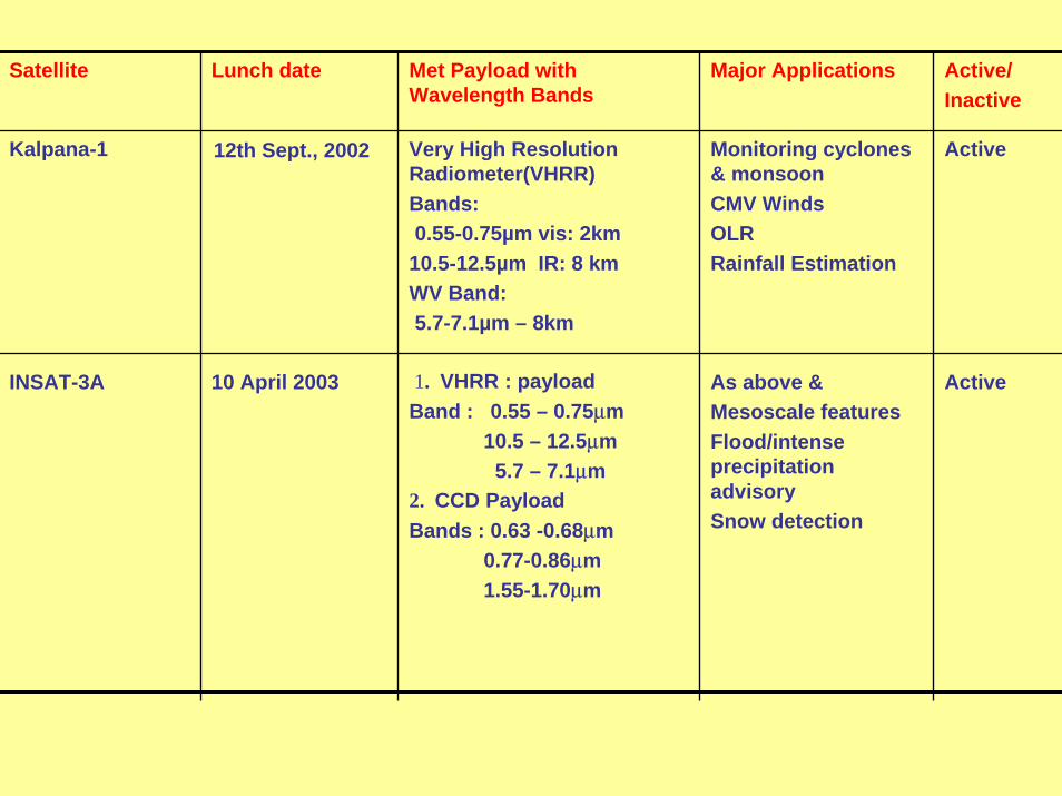
ActiveAs above &Mesoscale featuresFlood/intense precipitation advisorySnow detection
1. VHRR : payloadBand : 0.55 – 0.75µm
10.5 – 12.5µm5.7 – 7.1µm
2. CCD Payload Bands : 0.63 -0.68µm
0.77-0.86µm1.55-1.70µm
10 April 2003INSAT-3A
ActiveMonitoring cyclones & monsoonCMV WindsOLRRainfall Estimation
Very High Resolution Radiometer(VHRR)Bands:0.55-0.75µm vis: 2km
10.5-12.5µm IR: 8 kmWV Band:5.7-7.1µm – 8km
12th Sept., 2002Kalpana-1
Active/Inactive
Major ApplicationsMet Payload with Wavelength Bands
Lunch date Satellite
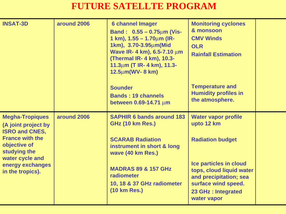
FUTURE SATELLTE PROGRAM
Monitoring cyclones & monsoonCMV WindsOLRRainfall Estimation
Temperature and Humidity profiles in the atmosphere.
6 channel ImagerBand : 0.55 – 0.75µm (Vis-1 km), 1.55 – 1.70µm (IR-1km), 3.70-3.95µm(Mid Wave IR- 4 km), 6.5-7.10 µm (Thermal IR- 4 km), 10.3-11.3µm (T IR- 4 km), 11.3-12.5µm(WV- 8 km)
SounderBands : 19 channels between 0.69-14.71 µm
around 2006INSAT-3D
Water vapor profile upto 12 km
Radiation budget
Ice particles in cloud tops, cloud liquid water and precipitation; sea surface wind speed.23 GHz : Integrated water vapor
SAPHIR 6 bands around 183 GHz (10 km Res.)
SCARAB Radiation instrument in short & long wave (40 km Res.)
MADRAS 89 & 157 GHz radiometer10, 18 & 37 GHz radiometer (10 km Res.)
around 2006Megha-Tropiques(A joint project by ISRO and CNES, France with the objective of studying the water cycle and energy exchanges in the tropics).

CYCLONE W ARNING DISSEM INATION SYSTEM (CW DS) IMD has installed 250 specially designed receivers w ithin the vulnerablecoastal areas for d irect transm ission of warnings to the officials and peopleusing broadcast capability of INSAT satellite. Recently th is technology has been upgraded to d ig ita l transmission. In itia lly 100 D igita l CW DS have been deployed in the coastal areas of Andhra Pradesh. Area Cyclone W arning Center (ACW C) special w arning bulletinstransm itted every hour in local language to the affected areas. M ETEOROLOGICAL DATA DISSEM INATION (M DD) Under this program analogue type cloud im agery data transm itted throughINSAT S-band broadcast along w ith other conventional m eteorological dataand FAX analysed and forecast weather charts. T here are 33 MDD receiving stations in India and also operating inneighboring countries at Sri Lanka and Male under b i-lateral agreem ent. In general processed im ages are sent every three hous, and every hourduring the cyclone period. INT ERNET PRODUCT S INSAT satellite processed G lobal and Sector im ages (IR , Visib le, W V) areprovided through IMD Internet web (www.im d.ernet.in) every three hours, and every hour during the cyclone period in real-tim e.


OTHER SATELLITE PRODUCTS PDUS for METEOSAT-5 data reception A PDUS receiving station installed in early 2000 in IMD, New Delhi toreceive high-resolution imagery data from METEOSAT-5 satellite located at 630 E. RECEPTION OF NOAA SATELLITE DATA The AVHRR and TOVS data from NOAA series of polar orbiting satellitesare received and processed by IMD at New Delhi and Chennai trough HRPTreceiving station. The New Delhi HRPT receiving station upgraded toreceive the NOAA (K, L, M, N series) satellite data. INDO-US co-operation INDO-US data exchange center has been established in 1999 for exchangeof data with NOAA/NASA under the co-operation in Earth AtmosphericSciences. IMD providing INSAT cloud imagery data every three hours in real-time to NOAA/NASA and receiving GOES satellite series data. These data products are being used by a number of scientists for specificstudies.
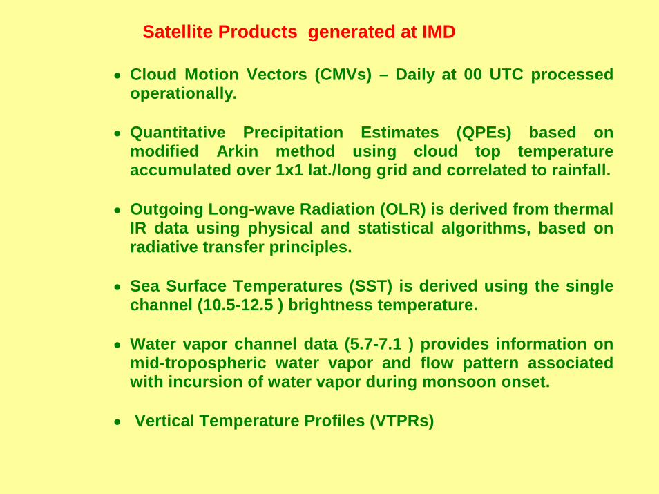
Satellite Products generated at IMD
• Cloud Motion Vectors (CMVs) – Daily at 00 UTC processedoperationally.
• Quantitative Precipitation Estimates (QPEs) based on
modified Arkin method using cloud top temperatureaccumulated over 1x1 lat./long grid and correlated to rainfall.
• Outgoing Long-wave Radiation (OLR) is derived from thermal
IR data using physical and statistical algorithms, based onradiative transfer principles.
• Sea Surface Temperatures (SST) is derived using the single
channel (10.5-12.5 ) brightness temperature.
• Water vapor channel data (5.7-7.1 ) provides information onmid-tropospheric water vapor and flow pattern associatedwith incursion of water vapor during monsoon onset.
• Vertical Temperature Profiles (VTPRs)

OLR
QPE

Synoptic Applications in IMD
• Major application, the monitoring of Synoptic weather systems
• Watch and monitor growth of rapidly
developing weather phenomena likecumulonimbus cells, thunderstormcomplexes
• Identify and locate primary synoptic
systems like troughs/ridges, jet streams and regions of intense convection, intertropical convergence zones etc.
• Monitor onset and progress of monsoon • Detect genesis and growth of Tropical
Cyclones and monitor their intensificationand movement till landfall.


Kalpana-I Satellite Imagery12 UTC/ 26 July 2003

Kalpana-I Satellite Imagery12 UTC/ 26 July 2003

Several satellite missions have been planned tosupport the operational data needs and ongoingresearch efforts.
The future INSAT missions will carry improved VHRRand vertical sounders for temperature/humidityprofiles.
The Megha -Tropiques Mission scheduled for 2006 with the objective of studying the water cycle and energyexchanges in the tropics.
With an equatorial inclined orbit, the satellite will havehigh repeativity over tropical regions.
The future appears bright for our space-based observing system. Advanced, multispectral (visible, IR, and passive microwave) imagers, sounders (infrared and microwave) and scatterometers are planned for launch in the near future.
Future missions

The satellite data downloads are expected to exceedseveral terabytes per day.
Fortunately, communications and computing capacityare increasing at a rate that hopefully canaccommodate this data explosion.
It is important that the evolving space-based observational system keep one step ahead of the demands being placed by the user community andadvances in numerical weather prediction.
While it will become an enormous task and challengeto assimilate this wealth of data into meaningful parameters, the outlook is bright for unlocking the still-unresolved mysteries towards improving ourunderstanding and prediction of atmospheric circulation systems such as tropical cyclones.

THANKS