Embed Size (px)
Citation preview

Inception, Deployment, Processing and Initial Results
of a Continuous GPS (cGPS) Network Across the
Lesser Antilles Arc: Implications for Caribbean Plate
Geodesy and Volcano Monitoring
Robert WATTS, Richard Robertson, Nico Fournier,
Lloyd Lynch, Machel Higgins & Henry Odbert
Seismic Research Centre, UWI, Trinidad & Tobago

MAIN AIMS OF THIS TALK:
1/ What is the primary role of the SRC ? 2/ Explain our ongoing continuous GPS network for the English –speaking Lesser Antillean islands to help determine plate motion? 3/ Explain our Volcano Monitoring Deformation Networks using the cGPS stations on each island? 4/ Receive advice & criticism from this audience. 5/ To let you all know we would ‘welcome’ any future collaborative ventures in our region.

0; 88; &(R46"11; 8/(S ; 2$%T%&' 8(
- ; "87 29; 4"#(T24; (
Puerto Rico
Trinidad
✕
Kick Em Jenny

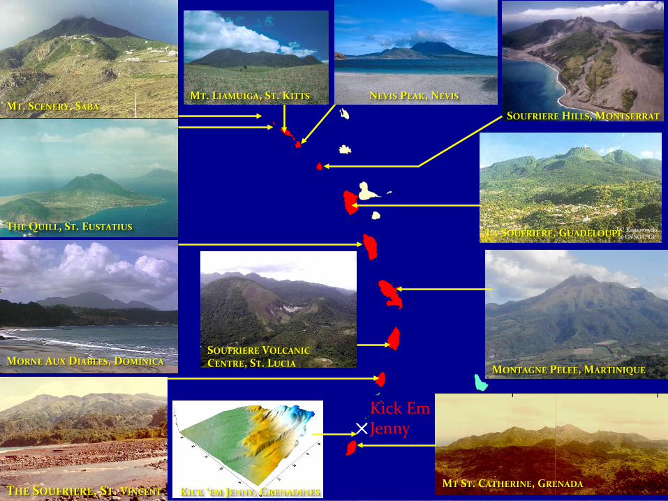
! "#$%&'"$#() (*+&, - " ', (. %/01+"2(((((((((! "#$%$&' (' )$34- &', 2() (52/ " - 6 '2((((((7- %8$(9+"4() (: - ;+%(. - %4<=/ - >$2(

Isle of Montserrat: Soufrière Hills Volcano (SHV) has been erupting for 17 years now – currently has a network of 11 continuously operating GPS stations (mostly Trimble NetRS) supervised in recent years by Dr. Henry Odbert.
★ SHV

Interesting SHV Relationship GPS & Eruptive Stages
5 ACTIVE episodes INFLATION – inactive period
DEFLATION - active period
GPS
SO2
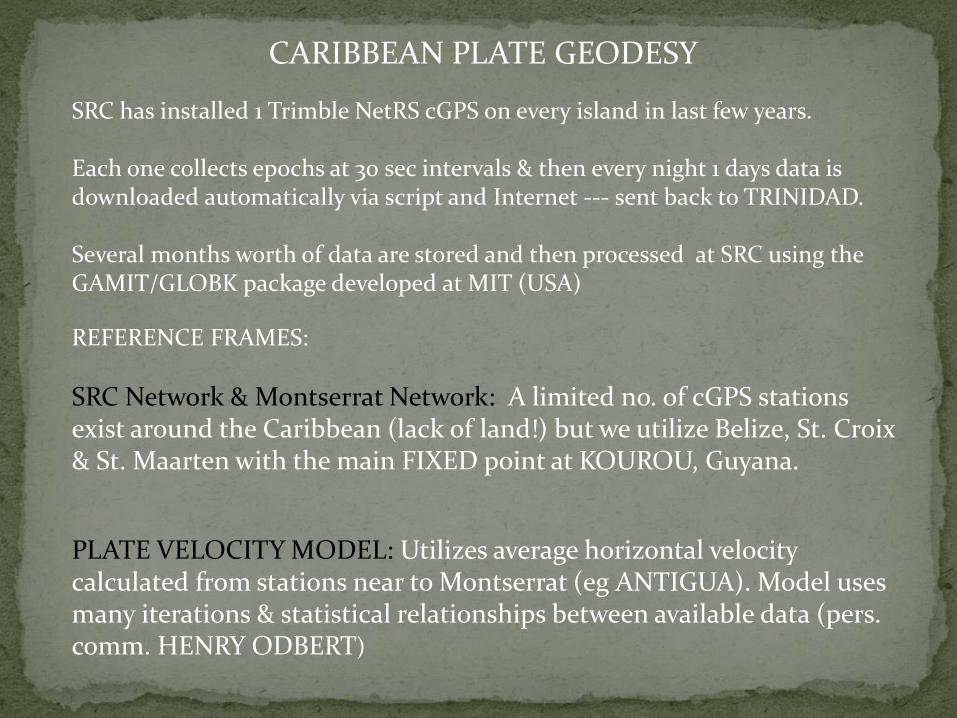
CARIBBEAN PLATE GEODESY
SRC has installed 1 Trimble NetRS cGPS on every island in last few years. Each one collects epochs at 30 sec intervals & then every night 1 days data is downloaded automatically via script and Internet --- sent back to TRINIDAD. Several months worth of data are stored and then processed at SRC using the GAMIT/GLOBK package developed at MIT (USA)
REFERENCE FRAMES:
SRC Network & Montserrat Network: A limited no. of cGPS stations exist around the Caribbean (lack of land!) but we utilize Belize, St. Croix & St. Maarten with the main FIXED point at KOUROU, Guyana.
PLATE VELOCITY MODEL: Utilizes average horizontal velocity calculated from stations near to Montserrat (eg ANTIGUA). Model uses many iterations & statistical relationships between available data (pers. comm. HENRY ODBERT)

Plate Motion Averages 19 mm to ENE generally, Grenada slightly more North. Trinidad: 5 cGPS stations on TnT show opposing trends of motion, is this a major plate boundary? (Weber et al, 2009)
T & T
Antigua
St. Vincent

VOLCANO DEFORMATION GPS SURVEYS
Example 1: DOMINICA 9 potentially active volcanoes
SURVEY TYPE: Rapid-Static Mode 3 Rover Kits Data collection - ONE sec intervals TWO Hour periods
Eg: Morne Aux Diables in North TWO cGPS sites ROSS + PNVL SEVEN rover sites around M.A.D.
SURVEY FREQUENCY: 6 months if possible due to VT earthquake activity since June 2009.
Process with Trimble Business Centre software
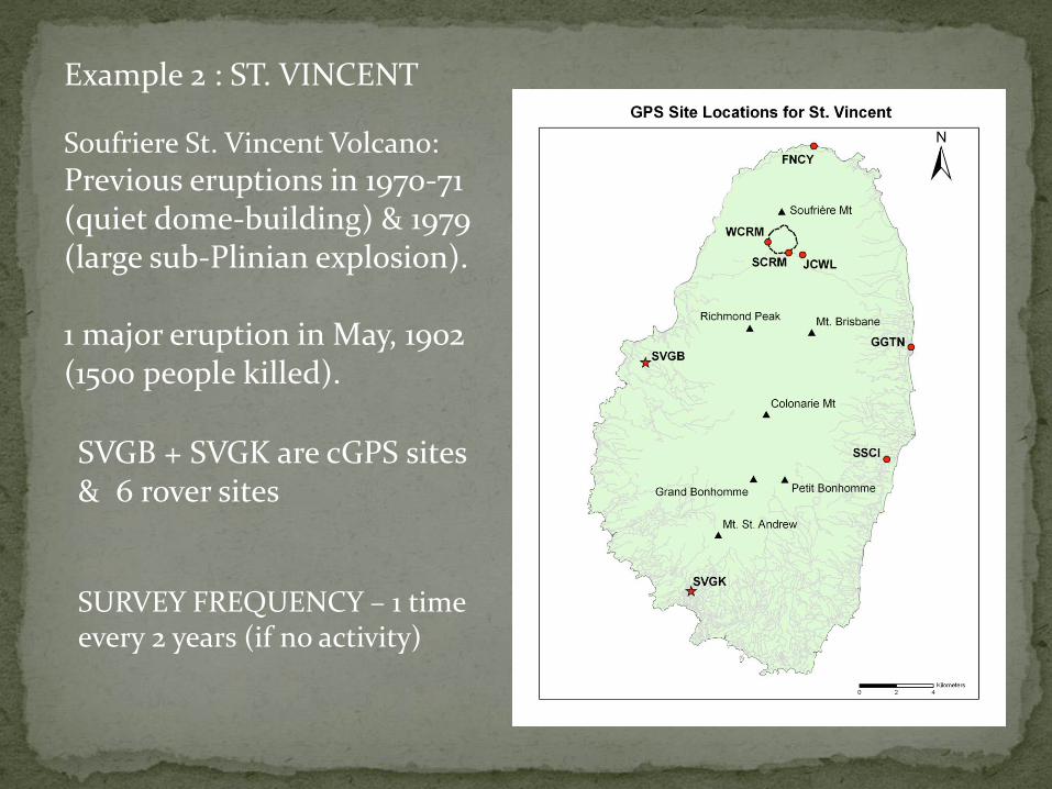
Example 2 : ST. VINCENT
Soufriere St. Vincent Volcano:
Previous eruptions in 1970-71 (quiet dome-building) & 1979 (large sub-Plinian explosion). 1 major eruption in May, 1902 (1500 people killed).
SVGB + SVGK are cGPS sites & 6 rover sites
SURVEY FREQUENCY – 1 time every 2 years (if no activity)

cGPS SITE LOCATIONS:
cGPS on Bath Hotel, NEVIS
Rover pin in ST. VINCENT
cGPS in Penville village on flanks of Morne Aux Diables, DOMINICA

R426$ ; &(=288"H1; (H; 4; G%#62&("8(6$ ; (A&2=28; ' (5 ) 5 ) . +, (#S A- (. ; 6Q2&D(
* ; "49(+86%H1"8$ ; ' (62(8?==2&6("4F; 86"9%6"24(2G(=&2#; 88K2&"; 46; ' (8#"; 4#; (U? ; 86"248(Q"6$ (' "&; #6(&; 1; F%4#; (62(; %&6$ (%4' (%67 28=$ ; &"#($%T%&' 8/(%4' (62(=&2F"' ; (G2&(&; 9"24%1(#%=%#"63(H? "1' "49(G2#?8; ' (24(8#"; 4#; (%4' ("46; &4%6"24%1(#211%H2&%6"248P(
FOUR SRC stations to be part of UNAVCO COCONET datashare project
UNAVCO (NSF funded) International
★

RECENT COLLABORATION WITH CHILEAN COLLEAGUES:
Me & Dr. Alvaro Amigo in front of Cerro Chao flow-front – future volcanology field projects together.
Acting Director of SRC (Dr. Joan Latchman) receiving gift of 2 cGPS instruments for Trinidad from Univ. of Chile (Sergio Barrientos).
SUMMARY
1/ SRC is very open to future collaborations … 2/ SRC is dedicated to monitoring all Caribbean natural hazards. 3/ I am keen to hear criticisms/comments on geodetic monitoring.