Embed Size (px)
Citation preview

Impulsfinanciering 2005
Zware Apparatuur
Deep Reef & Lake Surveyor
Activity Report 2006‒2011

TECHNISCHE SPECIFICATIES
Type Cherokee ROV, Sub Atlantic, Aberdeen
Dimensions
ROV
Length: 1400 mm
Width: 870 mm
Height: 1110 mm
Weight in air: 300 kg
TMS: Tethered Management system
Length: 1950 mm
Width: 1190 mm
Height: 2372 mm
Weight in air: 700 kg
Weight ROV + TMS + tether + equipment: 1500 kg
Depth rating 2000 m, limited to 1400 m by cable length
Thrusters 6 vectorized thrusters, powered by 440 VAC
Forward thrust 117 kgf
Lateral thrust 88 kgf
Vertical thrust 78 kgf
Cameras and lighting
Colour zoom: Kongsberg OE14-366/367, 460 TV lines, 0.02 lux sensitivity
Black and white: Kongsberg OE15-100a, 560 TV lines, 0.0013 lux sensitivity
Rear black and white: Kongsberg OE1358, 570 TV lines, 0.004 lux sensitivity
Digital stills: Kongsberg OE14-208, 5MP, 0.02 lux
Flash gun: Kongsberg OE 11-242, 80W/s light output
TMS camera: General purpose black and white
Video format: PAL
Video Output: Composite
External lights
Front: 3 x Q-LED from ROS, light output > 250 Watt
Rear 1 x Q-LED from ROS, light output > 250 Watt
TMS: 2 x 250 Watt halogen

Hydraulical Hydraulek HLK-EH5: 5 fie manipulator; medium duty work, lift capacity: 25 kg
Drawer in skid: Drawer for sample stowage
Sensors Standard on video overlay: Heading, Depth, Height, Roll, Pitch Obstacle avoidance sonar: Tritech super seaKing dual freq., 325/675 kHz
CTD CTD 90M probe from SST
extra sensors: Turbidity, Fluorometer, Oxygen
Sediment temperature: Micrel THP temperature probe
Side-scan sonar: Klein 3000 SSS, to be integrated
Client sensor on request: RS 232 ,12/24 VDC available
Laser for measuring purposes
Niskin bottles, operated by manipulator
push core device
Umbilicals
Live boating mode
500 meter tether, dia 30 mm
Weight in air: 750 kg/km
Weight in H20: 215kg/km
TMS mode
- 1600 m steel armored heavy lift cable, diameter 25.1 mm
Weight in air: 1550 kg/km
Weight in H2O: 1170 kg/km
Breaking strength: 230 kN
Min bending diameter: 900 mm
- 200 m tether on TMS, specs idem live boating
Conductors
copper for power, MultiMode fibre optics for telemetry
Power
Live boating mode
ROV system: 380-440 VAC, 32 Amps
Control system: 240 VAC, 16 Amps
TMS mode
ROV system: 380-440 VAC, 32 Amps
Winch : 380-440 VAC, 64-70 Amps
Control container: 240 VAC, 16 amps
Positioning
IXSEA GAPS: Plug and play USBL system, accuracy 0.2 %
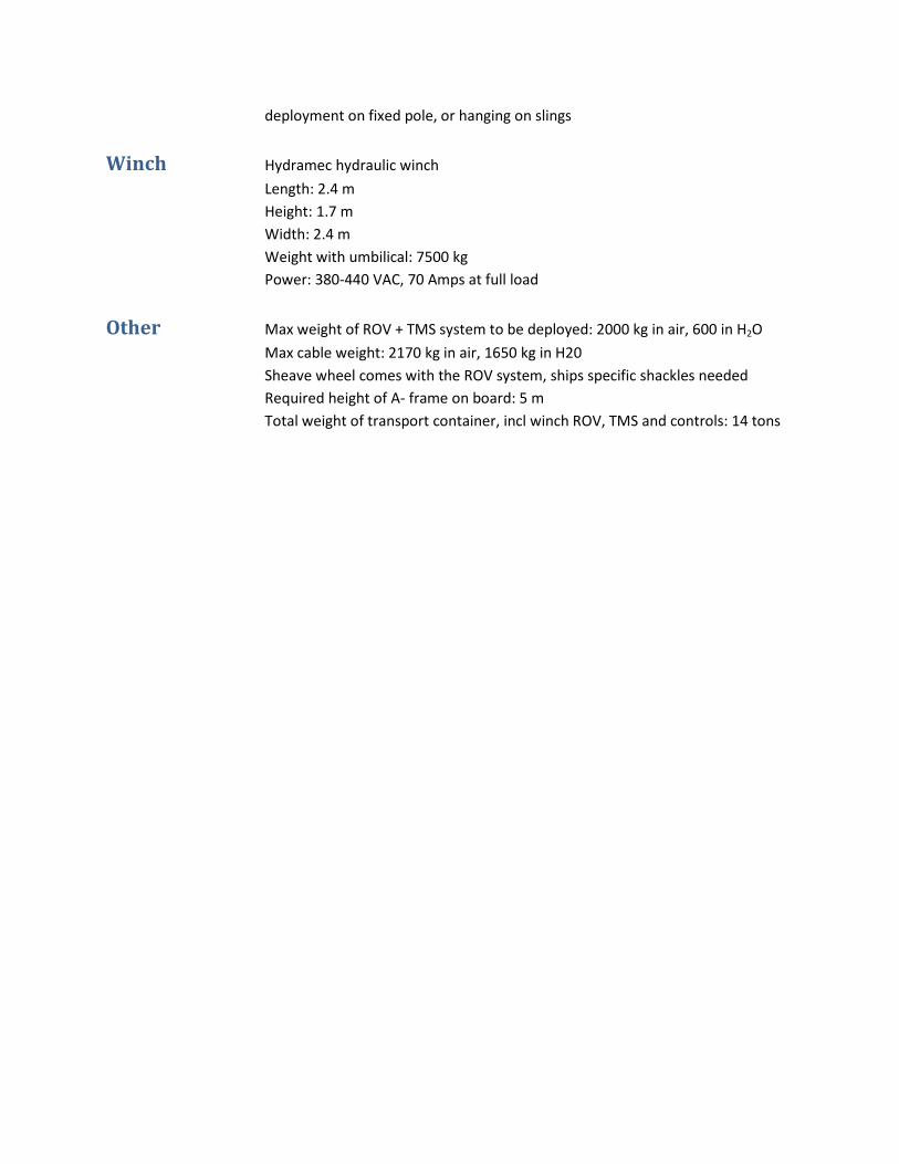
deployment on fixed pole, or hanging on slings
Winch Hydramec hydraulic winch
Length: 2.4 m
Height: 1.7 m
Width: 2.4 m
Weight with umbilical: 7500 kg
Power: 380-440 VAC, 70 Amps at full load
Other Max weight of ROV + TMS system to be deployed: 2000 kg in air, 600 in H2O
Max cable weight: 2170 kg in air, 1650 kg in H20
Sheave wheel comes with the ROV system, ships specific shackles needed
Required height of A- frame on board: 5 m
Total weight of transport container, incl winch ROV, TMS and controls: 14 tons

13-20 June 2006 R/V Belgica Belgica 06/12
La Chapelle Bank and Bantry Bay, North Atlantic Ocean Brest (France) – Cork (Ireland) UGent-RCMG research
Total dives: 10 Total observation time: 20 hours Depth range: 15-600 m
MAIN OBJECTIVE
First testing and deployment of the ROV at the sheltered environment of the Bay of Douarnenez and visual
observations on La Chapelle Bank
PROJECT
EU FP6 “HERMES”, EU FP5 RTN “EURODOM”, ESF EUROCORES EuroMargins “MOUNDFORCE”
PARTICIPANTS
UGent-RCMG (Belgium), NOC Southampton (UK), University College Cork (Ireland), IFREMER Brest(France)
SUMMARY
The main aim of this cruise was testing the ROV, which was successful. Lessons were learned in order to
improve the ROV for next cruises. Two successful dives on La Chapelle Bank revealed a sandy-muddy seabed
with intriguing bedforms and erosion exposing consolidated sedimentary sequences, often cut by vertical
cliffs up to 10 m high. At the base of the cliffs, fallen blocks provided settlement sites for sessile organisms
whilst the cliffs and protruding banks revealed dense communities of oysters with occasional cold-water coral
(Lophelia). Although deep-water ‘oyster banks’ had already been reported earlier by Le Danois (1948) on the
base of dredgings, these dramatic seascapes had remained largely hidden to the human eye up to now.
PUBLICATIONS
Van Rooij, D., De Mol, L., Le Guilloux, E., Wisshak, M., Huvenne, V.A.I., Moeremans, R. & Henriet, J.-P., 2010.
Environmental setting of deep-water oysters in the Bay of Biscay. Deep-Sea Research Part I, 57, 1561-1572.

06-21 September 2006 RRS Discovery Discovery D311
Denmark Strait, North Atlantic Ocean Reykjavik (Iceland) – Reykjavik (Iceland) Commissioned
Total dives: 1 Total observation time: 3 hours Depth range: 40-70 m
MAIN OBJECTIVE
Visual observations in Denmark Strait and recovery of moorings (test)
COMMISSIONER
Institut für Meereskunde, University of Hamburg (Germany)
BUDGET
travel/transport
PARTICIPANTS
UGent-RCMG (Belgium), University of Hamburg (Germany)
SUMMARY
Due to technical problems and bad weather conditions only a test-dive at the end of the survey was
successfully performed near the coast of Iceland. It resulted in good-quality video-pictures of the shelf
bottom. Also the technical knowledge of the ROV-system was greatly improved.
PUBLICATIONS
---
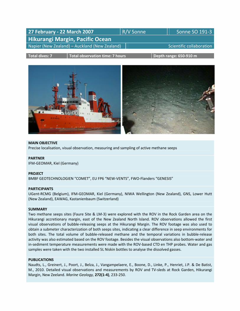
27 February - 22 March 2007 R/V Sonne Sonne SO 191-3
Hikurangi Margin, Pacific Ocean Napier (New Zealand) – Auckland (New Zealand) Scientific collaboration
Total dives: 7 Total observation time: 7 hours Depth range: 650-910 m
MAIN OBJECTIVE
Precise localisation, visual observation, measuring and sampling of active methane seeps
PARTNER
IFM-GEOMAR, Kiel (Germany)
PROJECT
BMBF GEOTECHNOLOGIEN “COMET”, EU FP6 “NEW-VENTS”, FWO-Flanders “GENESIS”
PARTICIPANTS
UGent-RCMG (Belgium), IFM-GEOMAR, Kiel (Germany), NIWA Wellington (New Zealand), GNS, Lower Hutt
(New Zealand), EAWAG, Kastanienbaum (Switzerland)
SUMMARY
Two methane seeps sites (Faure Site & LM-3) were explored with the ROV in the Rock Garden area on the
Hikurangi accretionary margin, east of the New Zealand North Island. ROV observations allowed the first
visual observations of bubble-releasing seeps at the Hikurangi Margin. The ROV footage was also used to
obtain a submeter characterization of both seeps sites, indicating a clear difference in seep environments for
both sites. The total volume of bubble-released methane and the temporal variations in bubble-release
activity was also estimated based on the ROV footage. Besides the visual observations also bottom-water and
in-sediment temperature measurements were made with the ROV-based CTD en THP probes. Water and gas
samples were taken with the two installed 5L Niskin bottles to analyse the dissolved gasses.
PUBLICATIONS
Naudts, L., Greinert, J., Poort, J., Belza, J., Vangampelaere, E., Boone, D., Linke, P., Henriet, J.P. & De Batist,
M., 2010. Detailed visual observations and measurements by ROV and TV-sleds at Rock Garden, Hikurangi
Margin, New Zeeland. Marine Geology, 272(1-4), 233-250.

03-15 June 2007 R/V Belgica Belgica 07/13
Gulf of Cadiz, North Atlantic Ocean Cadiz (Spain) – Cadiz (Spain) UGent-RCMG research
Total dives: 10 Total observation time: 19.5 hours Depth range: 300-700 m
MAIN OBJECTIVE
(1) Surveying and mapping of carbonate mound systems, (2) video-surveying of IODP ready sites, (3)
surveying of mud volcano craters to identify active seepage systems, and (4) deployment and retrieval of
colonisation experiments
PROJECT
EU FP6 “HERMES”, ESF EUROCORES EuroMargins “MOUNDFORCE”, ESF EUROCORES EuroMargins “MVSEIS”,
ESF EUROCORES EuroDiversity “MiCROSYSTEMS”, ESF EUROCORES EuroDEEP “CHEMECO”
PARTICIPANTS
UGent-RCMG (Belgium), UGent-MBS (Belgium), University of Aveiro (Portugal), Mohamed V University of
Rabat (Morocco)
SUMMARY
In total, three mud volcanoes were investigated, namely Mercator, Lazarillo de Tormes and Gemini mud
volcanoes. Unfortunately it was not possible to recover the colonisation experiment of the University of
Aveiro due to malfunctioning of the ROV arm. After repairing the arm the experiment of the Marine Biology
Section was deployed on Gemini mud volcano. In addition two cold-water coral mounds (Alpha and Beta
mound) were observed on Pen Duick Escarpment as well as the foot of the escarpment and a small mound on
Vernadsky Ridge was imaged.
PUBLICATIONS
De Mol, L., Hilàrio, A., Van Rooij, D. & Henriet, J.-P., (submitted). Habitat mapping of a cold-water coral
mound on Pen Duick Escarpment (Gulf of Cadiz). In: Harris, P., Baker, E. (eds.) Seafloor Geomorphology as
Benthic Habitat: GeoHab Atlas of seafloor geomorphic features and benthic habitats. Elsevier Insights.
De Mol, L., Larmagnat, S., de Haas, H., de Stigter, H., Mienis, F., Hilàrio, A., Pirlet, H., Frank, N., Van Rooij, D.,
Neuweiler, F., De Batist, M. & Henriet, J.-P., (in preparation). Cold-water coral graveyards on Pen Duick

Escarpment (Gulf of Cadiz): distribution and significance. Deep-Sea Research Part I.
Van Rooij, D., Blamart, D., De Mol, L., Maignien, L., Larmagnat, S., Mienis, F., Stadnitskaia, A., Wehrmann, L.,
Templer, S., Frank, N., Pirlet, H., Barbieri, R., de Haas, H., Stivaletta, N., Zhang, Y., Hamoumi, N., van Weering,
T., Henriet, J.-P. & the MiCROSYSTEMS MD169 shipboard party, (in press). Cold-water coral mounds on the
Pen Duick Escarpment, Gulf of Cadiz: the MiCROSYSTEMS approach. Marine Geology, doi:
10.1016/j.margeo.2010.08.012.

25 May - 07 June 2008 R/V Belgica Belgica 08/13a
Guilvinec Canyon (Bay of Biscay), North Atlantic Ocean Brest (France) – La Coruna (Spain) UGent-RCMG research
Total dives: 5 Total observation time: 13.5 hours Depth range: 250-900 m
MAIN OBJECTIVE
Visual observation and mapping of deep-sea ecosystems and targeted sampling
PROJECT
EU FP6 “HERMES”, ESF EUROCORES EuroDiversity “MiCROSYSTEMS”
PARTICIPANTS
UGent-RCMG (Belgium), IFREMER Brest (France)
SUMMARY
Two different cold-water coral reef settings were distinguished. In water depths ranging from 260 to 350 m,
mini mounds up to 5 m high, covered by dead cold-water coral rubble, were observed. The second setting
(350-950 m) features hard substrates with cracks, spurs, cliffs and overhangs. In water depths of 700 to 950
m, both living and dead cold-water corals occur. Occasionally, they form dense coral patches with a diameter
of about 10–60 m, characterised by mostly stacked dead coral rubble and a few living specimens. In addition,
deep-water pycnodontine oysters were observed. The combined use of multibeam bathymetry, seismic
profiling, CTD casts and ROV observations made it possible to describe the physical habitat and to assess the
oceanographic control for the recently described species Neopycnodonte zibrowii.
PUBLICATIONS
De Mol, L., Van Rooij, D., Pirlet, H., Greinert, J., Frank, N., Quemmerais, F. & Henriet, J.-P., (in press). Cold-
water coral habitats in the Penmarc’h and Guilvinec Canyons (Bay of Biscay) : deep-water versus shallow
water settings. Marine Geology, doi : 10.1016/j.margeo.2010.04.011.
Van Rooij, D., De Mol, L., Le Guilloux, E., Wisshak, M., Huvenne, V.A.I., Moeremans, R. & Henriet, J.-P., 2010.
Environmental setting of deep-water oysters in the Bay of Biscay. Deep-Sea Research Part I, 57, 1561-1572.

07-25 November 2008 R/V Pelagia Pelagia 64PE298
West Nile Delta, Mediterranean Sea Heraklion (Greece) – Port Said (Egypt) Commissioned
Total dives: 17 Total observation time: 60 hours Depth range: 400-500 m
MAIN OBJECTIVE
(1) Installation of temperature observatories and CAT meters for long term monitoring, (2) video monitoring
of seafloor structures of mud volcanoes, (3) deployment of an active source for CSEM measurements
COMMISSIONER
IFM-GEOMAR Kiel (Germany)
BUDGET
44 633 €
(excl. travel/transport)
PARTICIPANTS
UGent-RCMG (Belgium), IFM-GEOMAR Kiel (Germany)
SUMMARY
The survey area consisted of two mud volcanoes: North Alex and Giza. After two general reconnaissance
video dives of North Alex, a long term heatflow station was deployed with the aid of the ROV. A 10 m wide
EM-source was successfully implemented on the ROV. During 4 dives (total of 20 hrs) tracks were sailed

covering whole North Alex. Six CAT-meters were deployed (3 dives) by the ROV. Also heatflow (T-stick)
measurements at different sites and some push cores were taken in different dives. A general reconnaissance
video dive at Giza was followed by heatflow measurements, one CAT-meter deployment and some
pushcores. Also a lost transponder (20.000 Euro) was recovered.
PUBLICATIONS
---

18-27 May 2009 R/V Belgica Belgica 09/14b
Gulf of Cadiz, North Atlantic Ocean Cadiz (Spain) – Vigo (Spain) UGent-RCMG research
Total dives: 10 Total observation time: 9.5 hours Depth range: 350-1150 m
MAIN OBJECTIVE
(1) Recovery of colonisation devices on Mercator, Meknes and Darwin mud volcanoes; and (2) visual
observation of deep-water ecosystems on top of cold-water coral mounds (Pen Duick Escarpment) for habitat
and environmental mapping
PROJECT
EC FP7 “HERMIONE”, ESF EUROCORES EuroDEEP “CHEMECO”
PARTICIPANTS
UGent-RCMG (Belgium), University of Aveiro (Portugal), Laval University (Canada), Mohamed V University of
Rabat (Morocco)
SUMMARY
(1) Each colonisation set, composed of three devices loaded with different types of substrate (carbonate,

wood and alfalfa), was recovered. Each device was photographed and fixed following specific protocols for
the study of the microbial film and the taxonomic and trophic characterisation of colonising metazoans. (2)
The ROV observations will allow a detailed study of the distribution and significance of cold-water corals and
discuss their role in the build-up of cold-water coral mounds and their potential for the reconstruction of
palaeoceanographic conditions.
PUBLICATIONS
De Mol, L., Hilàrio, A., Van Rooij, D. & Henriet, J.-P., (submitted). Habitat mapping of a cold-water coral
mound on Pen Duick Escarpment (Gulf of Cadiz). In: Harris, P., Baker, E. (eds.) Seafloor Geomorphology as
Benthic Habitat: GeoHab Atlas of seafloor geomorphic features and benthic habitats. Elsevier Insights.
De Mol, L., Larmagnat, S., de Haas, H., de Stigter, H., Mienis, F., Hilàrio, A., Pirlet, H., Frank, N., Van Rooij, D.,
Neuweiler, F., De Batist, M. & Henriet, J.-P., (in preparation). Cold-water coral graveyards on Pen Duick
Escarpment (Gulf of Cadiz): distribution and significance. Deep-Sea Research Part I.
Van Rooij, D., Blamart, D., De Mol, L., Maignien, L., Larmagnat, S., Mienis, F., Stadnitskaia, A., Wehrmann, L.,
Templer, S., Frank, N., Pirlet, H., Barbieri, R., de Haas, H., Stivaletta, N., Zhang, Y., Hamoumi, N., van Weering,
T., Henriet, J.-P. & the MiCROSYSTEMS MD169 shipboard party, (in press). Cold-water coral mounds on the
Pen Duick Escarpment, Gulf of Cadiz: the MiCROSYSTEMS approach. Marine Geology, doi:
10.1016/j.margeo.2010.08.012.

30 May – 08 June 2009 R/V Belgica Belgica 09/14c
Cabo Ortegal, North Atlantic Ocean Vigo (Spain) – Zeebrugge (Belgium) UGent-RCMG research
Total dives: 3 Total observation time: 3.5 hours Depth range: 400-800 m
MAIN OBJECTIVE
Visual observation and mapping of seafloor ecosystems as well as sampling of sponges associated with cold-
water corals
PROJECT
EC FP7 “HERMIONE”, ESF EUROCORES EuroDEEP “BIOFUN”
PARTICIPANTS
UGent-RCMG (Belgium), UGent-MBS (Belgium), University of Santiago de Compostella (Spain), University of
Amsterdam (The Netherlands)
SUMMARY
Two dives were taking place in an area of so-called mini mounds whereas the third dive took place in an area
where coral rubble was recovered by means of dredge samples during the RV Sarmiente de Gamboa cruise in
2008. The seafloor consisted of bioturbated soft sediment with on a regular base small to larger pieces of
dead coral (Lophelia pertusa). In addition, anemones, crinoids, gastropods, holothurians, sea pens, hermit
crabs and a few galatheid lobsters were observed.
PUBLICATIONS
Verreydt, W., 2011. Late Cenozoic sedimentary processes on the outer edge of the NW Iberian shelf, Cabo
Ortegal. MSc Thesis.

04 January – 02 March 2010 RVIB N.B. Palmer Palmer 10-01
Antarctic Peninsula Punta Arenas (Chile) – Punta Arenas (Chile) Scientific collaboration
Total dives: 10 Total observation time: 30 hours Depth range: 160-1420 m
MAIN OBJECTIVE
Visualisation and sampling of ecosystems (including methane seeps) at the newly accessible seafloor below
the recently disintegrated Larsen B ice shelf
PARTNER
Hamilton College, Clinton NY (USA)
PROJECT
NSF “Larissa”, BELSPO “HOLANT”
PARTICIPANTS
UGent-RCMG (Belgium), Hamilton College, Clinton NY (USA), University of Hawaii at Manoa (USA), University
of Colorado, Boulder (USA), Duke University, Beaufort (USA), Ohio State University, Columbus (USA), Scripps
Institute of Oceanography, San Diego (USA), Lamont-Doherty Earth Observatory, New York (USA), Korean
Polar Research Institute, Incheon (Korea)
SUMMARY
Due to severe sea ice conditions, the Larsen B study area could not be reached by RVIB NBP during the 2010
Larissa expedition. As a backup plan several locations at the western and eastern side of the Antarctica
Peninsula were explored with the ROV to study submerged ice shelf moraines, sediment drifts, several
circular basins at the western side of the Antarctic Peninsula, a submarine volcano and different fjord basins.
At these different environments, epibenthic fauna was recognized, quantified and sampled and compared in
relation to their habitats. The main discovery was the presence of invasive lithodid crab species in the Palmer
Deep basin.
PUBLICATIONS
Smith et al., (in preparation). Large, reproductive population of Neolithodes yaldwyni on the West Antarctic
shelf. Proceedings of the Royal Society.

7-16 June 2010 R/V Belgica Belgica 10/17a
Guilvinec Canyon, Bay of Biscay, North Atlantic Ocean Zeebrugge (Belgium) – La Rochelle (France) UGent-RCMG research
Total dives: 3 Total observation time: 7 hours Depth range: 650-1100 m
MAIN OBJECTIVE
Visual observation of deep-water ecosystems (mainly cold-water corals) for habitat and environmental
mapping
PROJECT
EC FP7 “HERMIONE”
PARTICIPANTS
UGent-RCMG (Belgium), IFREMER Brest (France)
SUMMARY
Due to bad weather, only three dives were carried out during this cruise. Thick cold-water coral rubble
graveyards with living corals on top were observed, often colonised by sponges, crinoids, antipatharians and
soft corals. Madrepora oculata and Lophelia pertusa are the most common species. In addition, a lot of trawl
marks were observed.
PUBLICATIONS
---

19-28 June 2010 R/V Belgica Belgica 10/17b
Whittard Canyon, Bay of Biscay, North Atlantic Ocean La Rochelle (France) – Zeebrugge (Belgium) UGent-RCMG research
Total dives: 5 Total observation time: 9 hours Depth range: 450-1150 m
MAIN OBJECTIVE
Benthic habitat mapping and groundtruthing of previously observed acoustic features
PROJECT
EC FP7 “HERMIONE”
PARTICIPANTS
UGent-RCMG (Belgium), UGent-MBS (Belgium), University College Cork (Ireland)
SUMMARY
During theses dives, (rippled) soft sediment, often colonized by numerous pennatulids, was seen alternately
with hard substrates in the shape of small banks, ridges and/or large cliffs with heights varying between 10
cm and 8 m (even one cliff of about 50 m high). The area was characterised by an irregular topographic relief
with steep slopes and frequent evidence of downslope transport. Mostly dead cold-water coral rubble was
observed with occasional living cold-water corals (Lophelia pertusa and Madrepora oculata) on top of the
rubble. Several Dendrophyllia sp. and Desmophyllum species were noticed, as well as debris from the deep-
water oyster Neopycnodonte zibrowii.
PUBLICATIONS
---

24 September -08 October 2010 R/V M.S. Merian Merian MSM 16/2
Håkon Mosby Mud Volcano, North Atlantic Ocean Tromsø (Norway) – Tromsø (Norway) Commissioned
Total dives: 6 Total observation time: 17 hours Depth range: 1200-1250 m
MAIN OBJECTIVE
(1) Recovery of seafloor observatory “LOOME”, (2) deployment of temperature lance and camera, (3) video-
surveying of the Håkon Mosby mud volcano.
COMMISSIONER
Max Planck Institute for Marine Microbiology, Bremen (Germany)
BUDGET
42 566 €
(excl. travel/transport)
PARTICIPANTS
UGent-RCMG (Belgium), Max Planck Institute for Marine Microbiology, Bremen (Germany)
SUMMARY
During a reconnaissance dive of the mud volcano the seafloor observatory “LOOME” and still-camera were
easily found and recovered on the next dive. The T-lance was found around 160 m to the south and
recovered on the 4th
dive. Three wooden blocks for a colonization experiment were taken in the 5th
dive. In

the 6th
dive temperature-stick measurements were acquired at 13 sites. Next to this, video-surveying over
selected sites was also undertaken during these dives to map e.g. the distribution of gas flares, recent mud
volcanism and benthic habitats.
PUBLICATIONS
---

04-18 October 2011 RV S. Surveyor ss2011_v05
Offshore Northern Perth Basin, Indian Ocean Fremantle (Australia) – Fremantle (Australia) Commissioned
Total dives: 10 Total observation time: 21 hours Depth range: 300-800 m
MAIN OBJECTIVE
Quantifying hydrocarbon migration and seepage in the offshore Northern Perth Basin, and its effect on
benthic biota
COMMISSIONER
Royal NIOZ (Netherlands), Geoscience Australia (Australia)
BUDGET
travel/transport/maintenance
PARTICIPANTS
UGent-RCMG (Belgium), Royal NIOZ (Netherlands), Geoscience Australia (Australia)
SUMMARY
Despite 21 h of video surveying, no hydrocarbon migrations or seepages were spotted. A reconnaissance
survey (prior to our survey) of multibeam and subbottom profiles had also not been successful in revealing
seepage structures. The study area consisted mainly of a sandy-muddy seabed with consolidated bed forms
in some areas.
PUBLICATIONS
---
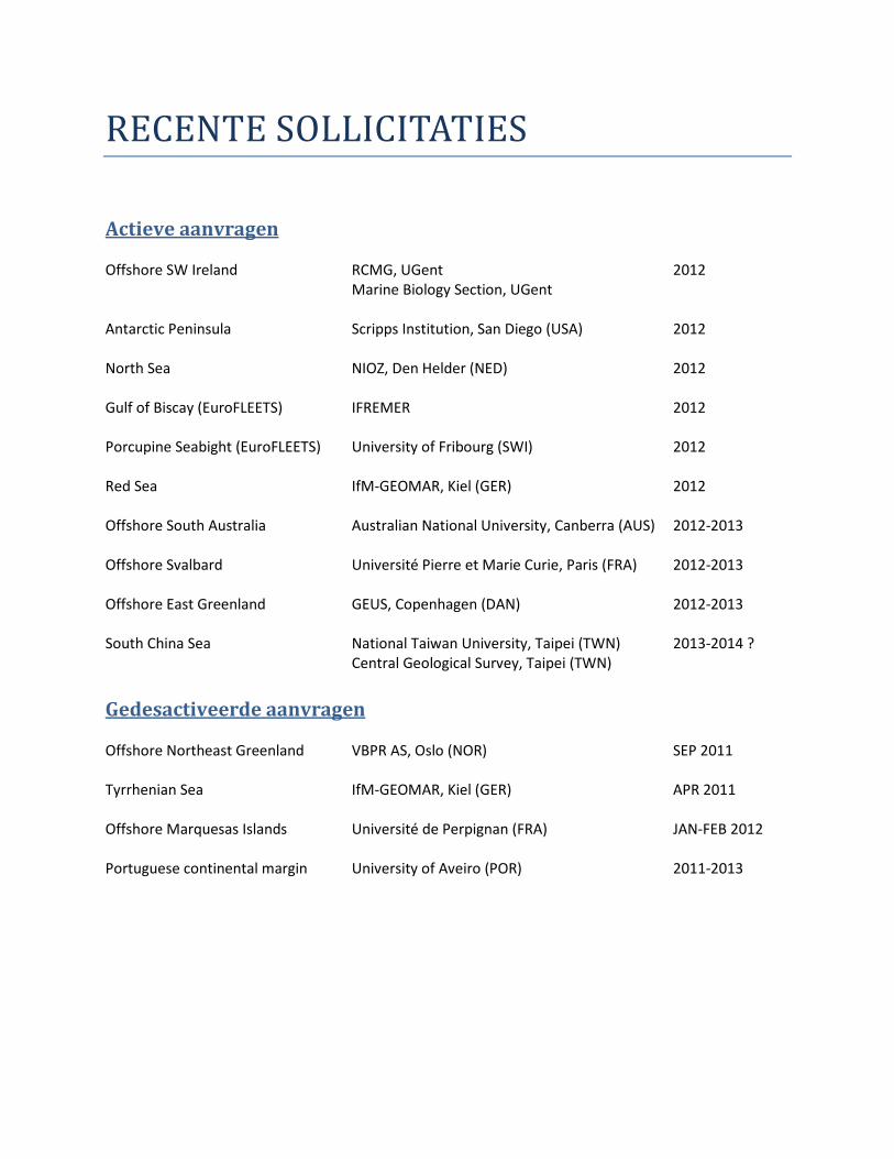
RECENTE SOLLICITATIES
Actieve aanvragen
Offshore SW Ireland
RCMG, UGent
Marine Biology Section, UGent
2012
Antarctic Peninsula Scripps Institution, San Diego (USA) 2012
North Sea NIOZ, Den Helder (NED) 2012
Gulf of Biscay (EuroFLEETS) IFREMER 2012
Porcupine Seabight (EuroFLEETS) University of Fribourg (SWI) 2012
Red Sea IfM-GEOMAR, Kiel (GER) 2012
Offshore South Australia Australian National University, Canberra (AUS) 2012-2013
Offshore Svalbard Université Pierre et Marie Curie, Paris (FRA) 2012-2013
Offshore East Greenland GEUS, Copenhagen (DAN) 2012-2013
South China Sea National Taiwan University, Taipei (TWN)
Central Geological Survey, Taipei (TWN)
2013-2014 ?
Gedesactiveerde aanvragen
Offshore Northeast Greenland VBPR AS, Oslo (NOR) SEP 2011
Tyrrhenian Sea IfM-GEOMAR, Kiel (GER) APR 2011
Offshore Marquesas Islands Université de Perpignan (FRA) JAN-FEB 2012
Portuguese continental margin University of Aveiro (POR) 2011-2013