Embed Size (px)
Citation preview

___________________________________________________________________
Earth System
Ministry
India
Current Weather Status and Outlook
Significant Features during past week
o Scattered Thunderstorm Activity
rain/thundershowers along with isolated thunder squalls had been observed over
northeast India on three to four days during the week with isolated intense rainfall
activity reported on one or two days over the region. Scatte
rain/thundershowers along with isolated thunder squalls had been observed over
parts of east India also during the same period.
o Heavy Rainfall Activity:
rainfall at isolated places had been reported over Nagaland, Manipur, Mizoram &
Tripura on one day each during the week.
o Temperature Scenario:
recorded at Khargone (West Madhya Pradesh) on 29
plains of the country during the week.
o Heat wave: Heat wave conditions had been reported over many parts of East &
West Madhya Pradesh and over some parts of Rajasthan,Saurashtra & Kutch and
Vidarbha on one or two days during the week.
reported at isolated places over Gujarat region and Saurashtra & Kutch on many
days; over West Rajasthan, Madhya Maharashtra, Marathwada, East and West
Madhya Pradesh and Chhattisgarh on two days each and over Haryana , East
Rajasthan and Vidarbha on one
Weekly Rainfall Scenario (28 March
During the week, rainfall
country as a whole. Details are given
_____________________________________________________________________________________________________
Government of India
System Science Organization
Ministry of Earth Sciences
India Meteorological Department
Dated:
Outlook for next two weeks (04-17 April, 2019
during past week (28 March to 03 April, 2019)
Thunderstorm Activity: Fairly widespread to widespread
rain/thundershowers along with isolated thunder squalls had been observed over
northeast India on three to four days during the week with isolated intense rainfall
activity reported on one or two days over the region. Scattered to fairly widespread
rain/thundershowers along with isolated thunder squalls had been observed over
parts of east India also during the same period.
Heavy to very heavy rainfall at isolated places and heavy
rainfall at isolated places had been reported over Nagaland, Manipur, Mizoram &
Tripura on one day each during the week.
The highest maximum temperature of 44.5
recorded at Khargone (West Madhya Pradesh) on 29th and 30th March 2019
e country during the week.
Heat wave conditions had been reported over many parts of East &
West Madhya Pradesh and over some parts of Rajasthan,Saurashtra & Kutch and
Vidarbha on one or two days during the week. Heat wave conditions had been
reported at isolated places over Gujarat region and Saurashtra & Kutch on many
days; over West Rajasthan, Madhya Maharashtra, Marathwada, East and West
Madhya Pradesh and Chhattisgarh on two days each and over Haryana , East
Rajasthan and Vidarbha on one day each during the week..
March to 03 April, 2019)
was below Long Period Average (LPA) by
given below:
__________________________________
: 04 April, 2019
2019)
Fairly widespread to widespread
rain/thundershowers along with isolated thunder squalls had been observed over
northeast India on three to four days during the week with isolated intense rainfall
red to fairly widespread
rain/thundershowers along with isolated thunder squalls had been observed over
Heavy to very heavy rainfall at isolated places and heavy
rainfall at isolated places had been reported over Nagaland, Manipur, Mizoram &
The highest maximum temperature of 44.5°C had been
March 2019 over the
Heat wave conditions had been reported over many parts of East &
West Madhya Pradesh and over some parts of Rajasthan,Saurashtra & Kutch and
Heat wave conditions had been
reported at isolated places over Gujarat region and Saurashtra & Kutch on many
days; over West Rajasthan, Madhya Maharashtra, Marathwada, East and West
Madhya Pradesh and Chhattisgarh on two days each and over Haryana , East
by 42% over the

2
Regions Actual
Rainfall (mm)
Normal
Rainfall (mm) % Departure from
LPA
Country as a whole 4.3 7.3 -42%
Northwest India 1.3 7.1 -82%
Central India 0.8 2.4 -65%
South Peninsula 1.8 3.8 -54%
East & northeast India 20.4 22.4 -09%
The Meteorological sub-division-wise rainfall for the week is given in Annexure I.
Seasonal Rainfall Scenario (01 March to 03 April, 2019)
For the country as a whole, cumulative rainfall during this year’s pre-monsoon
season upto 03rd April is below LPA by 37%. Details of the rainfall distribution over the four
broad geographical regions of India are given below:
Regions Actual
Rainfall (mm)
Normal
Rainfall (mm) % Departure from
LPA
Country as a whole 21.5 34.4 -37%
Northwest India 26.0 51.1 -49%
Central India 8.2 10.6 -22%
South Peninsula 5.2 13.8 -62%
East & northeast India 61.2 77.0 -21%
Cumulative seasonal rainfall is given in Annexure II.
Chief synoptic conditions as on 04 April, 2019
o A feeble Western Disturbance as a cyclonic circulation lies over east Afghanistan &
neighbourhood at 3.1 km above mean sea level.
o A cyclonic circulation lies over West Rajasthan & adjoining central Pakistan at lower
levels.
o A trough runs from the above cyclonic circulation to north Madhya Pradesh across
East Rajasthan at lower levels.
o A trough runs from west Vidarbha to Coastal Karnataka across Marathwada &
Madhya Maharashtra at 1.5 km above mean sea level.
o Another cyclonic circulation lies over east Bihar & neighbourhood at lower levels.
o A cyclonic circulation lies over northeast Assam & neighbourhood at 1.5 km above
mean sea level.
3
Large scale features as on 04 April, 2019
o Currently, weak El Niño conditions have developed over equatorial Pacific Ocean
and the latest Monsoon Mission Climate Forecasting System (MMCFS) forecast
indicates that these conditions are likely to persist in early part of the summer
season and likely to weaken thereafter.
o At present, neutral Indian Ocean Dipole (IOD) conditions are observed over Indian
Ocean and the latest MMCFS forecast indicates neutral IOD conditions are likely to
continue for coming forecasted seasons.
o The Madden–Julian Oscillation (MJO) at present lies over Phase -8 with very weak
amplitude. It is very likely to move towards Phase 1 with weak amplitude during next
one week.
Forecast for next two week
Weather systems & associated Precipitation during Week 1(04 to10 April, 2019) and
Week 2 (11 to17 April, 2019)
Rainfall for week 1: (04 to10 April, 2019)
o Pre- monsoon convective activity is likely to cause scattered to fairly widespread /
widespread rainfall with isolated thunder squalls over west Bengal & Sikkim, adjoining
parts of Bihar, Jharkhand and Odisha and over northeastern states ( Arunachal
Pradesh, Assam & Meghalaya and Nagaland, Manipur, Mizoram & Tripura) on most of
the days during the week 1 and on a few day during week-2. Though the western
Disturbances affecting the western Himalayan region (WHR) are likely to remain feeble,
these, along with other cyclonic circulations are likely to cause isolated to scattered rain
/ thundershowers over WHR and isolated rain / thundershowers and occasional Dust
storms over Punjab, Haryana, Chandigarh & Delhi, Uttar Pradesh and north Rajasthan.
The seasonal north-south trough / wind discontinuity and moisture incursion from the
Bay of Bengal is likely to cause isolated rain / thundershowers over central India
(Madhya Pradesh, Chhattisgarh and Vidarbha) and also over the southern states
(Kerala, Karnataka, Andhra Pradesh and Telangana) on most of the days during this
period.
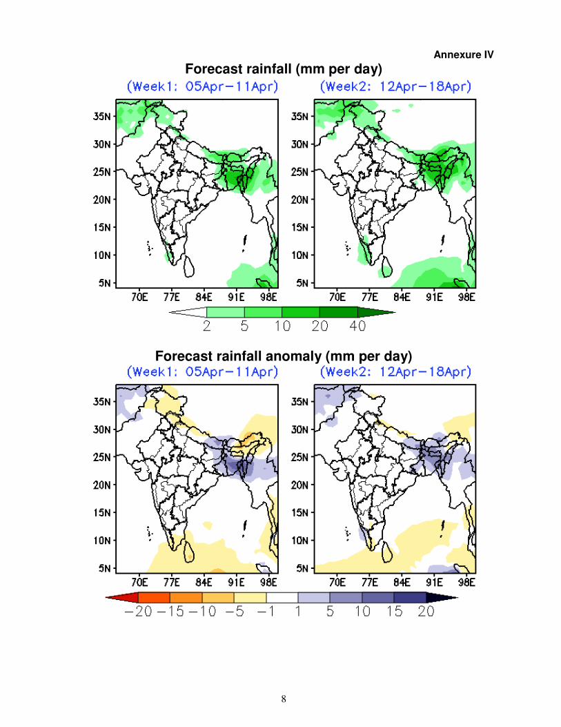
o Cumulatively, normal to above normal rainfall likely over west Bengal & Sikkim,
Mizoram, Tripura and over the eastern parts of Bihar and Jharkhand, below normal
over Jammu & Kashmir, Himachal Pradesh, Uttarakhand, Tamil Nadu, Puducherry and
Kerala and near normal elsewhere during week -1 (Annexures III & IV).
4
Rainfall for week 2: (11 to17 April, 2019)
o Above normal rainfall likely over west Bengal & Sikkim, Assam, Meghalaya,
Manipur, Mizoram, Tripura and north Kerala, below normal over south Kerala,
south Tamil Nadu and east Arunachal Pradesh and near normal over the rest of
the country (Annexure IV).
Maximum Temperature for week 1 & 2: (04 to 17 April, 2019)
o Above normal (by 3-4ºC) day maximum temperatures are likely over most parts of
Rajasthan, adjoining north Gujarat, Punjab, Haryana, Jammu & Kashmir, Himachal
Pradesh, Uttarakhand, Uttar Pradesh, northern districts of Madhya Pradesh, Odisha
and some parts of Chhattisgarh, Konkan & Goa, Tamil Nadu & Puducherry, north
coastal Andhra Pradesh, Arunachal Pradesh and east Assam and normal to slightly
below normal (by 1-2ºC) over the rest of India during week -1.
o Heat Wave conditions in some parts very likely over West Rajasthan and in
isolated pockets over Madhya Pradesh, south Haryana and East Rajasthan on
tomorrow.
o Warmer than normal day maximum temperatures (by 3-4ºC) are likely over most parts
of Odisha, south Chhattisgarh, Jammu & Kashmir and Himachal Pradesh and above
normal by 2-3ºC over Rajasthan, Punjab, Haryana, Chandigarh & Delhi, Uttar Pradesh,
northwest Madhya Pradesh, east Madhya Pradesh, Arunachal Pradesh, east Assam,
Gujarat, Konkan & Goa and adjoining Ghat areas of Maharashtra, coastal & south
interior Karnataka, Tamil Nadu & Puducherry and north coastal Andhra Pradesh, during
week- 2. Near normal to slightly below normal (by 1-2ºC) maximum temperatures are
likely over the rest of India during this period. (Annexure V).
o There is likelihood of development of heat wave conditions over Odisha and
adjoining areas of coastal Andhra Pradesh on a few days during week-2. Parts of
north and central India may also experience heat wave occasionally during this
period.
Cyclogenesis:
o No cyclogenesis is likely over the Indian Seas during next 2 weeks.
Next weekly update will be issued on next Thursday i.e. 11 April, 2019

5
Annexure I
10

6
Annexure II

7
Annexure III
METEOROLOGICAL SUB-DIVISIONWISE WEEKLY RAINFALL FORECAST & Wx. WARNINGS-2019
Sr. No MET.SUB-DIVISIONS 04 APR 05 APR 06 APR 07 APR 08 APR 09 APR 10 APR
1 ANDAMAN & NICO.ISLANDS SCT ISOL D D ISOL ISOL ISOL
2 ARUNACHAL PRADESH SCT TS ISOL SCT FWS FWS SCT SCT
3 ASSAM & MEGHALAYA SCT TS ISOL SCT TS FWS$ WS$ FWS TS SCT
4 NAGA.MANI.MIZO.& TRIPURA ISOL TS ISOL SCT TS FWS$ WS$ WS TS FWS
5 SUB-HIM.W. BENG. & SIKKIM SCT FWS FWS$● SCT SCT FWS TS SCT
6 GANGETIC WEST BENGAL ISOL SCT$ SCT$● FWS TS SCT SCT TS ISOL
7 ODISHA ISOL ISOL ISOL TS ISOL TS ISOL TS ISOL TS ISOL TS
8 JHARKHAND D ISOL SCT TS ISOL TS ISOL ISOL ISOL
9 BIHAR ISOL ISOL$ SCT$ ISOL ISOL ISOL ISOL
10 EAST UTTAR PRADESH D D ISOL TS ISOL ISOL ISOL D
11 WEST UTTAR PRADESH D ISOL ISOL TS ISOL ISOL TS ISOL D
12 UTTARAKHAND D ISOL ISOL ISOL ISOL ISOL ISOL
13 HARYANA CHD. & DELHI D���� + ISOL����
+ TS DS ISOL TS DS ISOL ISOL ISOL D
14 PUNJAB D ISOL TS DS ISOL TS DS ISOL ISOL ISOL D
15 HIMACHAL PRADESH D ISOL ISOL ISOL ISOL FWS SCT
16 JAMMU & KASHMIR ISOL ISOL ISOL ISOL SCT FWS FWS
17 WEST RAJASTHAN D���� + ISOL����
+ TS DS D D ISOL D D
18 EAST RAJASTHAN D���� + ISOL����
+ TS DS ISOL ISOL ISOL D D
19 WEST MADHYA PRADESH D���� + ISOL����
+ ISOL ISOL D D D
20 EAST MADHYA PRADESH D���� + D����
+ ISOL D D D D
21 GUJARAT REGION D.D. & N.H. D���� + D D D D D D
22 SAURASTRA KUTCH & DIU D���� + D D D D D D
23 KONKAN & GOA ISOL ISOL D D D D D
24 MADHYA MAHARASHTRA ISOL TS ISOL D D D D ISOL
25 MARATHAWADA ISOL TS ISOL D D D D D
26 VIDARBHA ISOL���� + TS ISOL TS D D D ISOL D
27 CHHATTISGARH ISOL TS ISOL TS ISOL ISOL ISOL ISOL ISOL
28 COASTAL ANDHRA PRADESH ISOL TS ISOL TS ISOL ISOL ISOL ISOL TS ISOL TS
29 TELANGANA ISOL TS ISOL ISOL D ISOL ISOL ISOL
30 RAYALASEEMA D D D D ISOL ISOL ISOL
31 TAMILNADU & PUDUCHERRY D D D ISOL ISOL ISOL ISOL
32 COASTAL KARNATAKA ISOL TS ISOL TS D ISOL ISOL ISOL ISOL
33 NORTH INT.KARNATAKA ISOL TS ISOL TS ISOL D D ISOL ISOL
34 SOUTH INT.KARNATAKA ISOL TS ISOL ISOL ISOL ISOL ISOL ISOL
35 KERALA ISOL TS ISOL TS ISOL ISOL SCT TS SCT ISOL
36 LAKSHADWEEP ISOL D D D D D D LEGENDS:
WS WIDE SPREAD / MOST PLACES (76-100%) FWS FAIRLY WIDE SPREAD / MANY PLACES (51% to 75%)
SCT SCATTERED / FEW PLACES (26% to 50%) ISOL ISOLATED (up to 25%) D/DRY NIL RAINFALL
● Heavy Rainfall (64.5-115.5 mm)
●●
Heavy to Very Heavy Rainfall (115.6-204.4 mm) ●●●
Extremely Heavy Rainfall (204.5 mm or more)
���� FOG * SNOWFALL # HAILSTORM ����
+ HEAT WAVE (+4.5
OC to +6.4
OC) ����
++ SEVERE HEAT WAVE (> +6.4)
$ THUNDERSTORM WITH SQUALL/GUSTY WIND
DS/TS DUST/THUNDERSTORM ���� -COLD WAVE (-4.5
OC to -6.4
OC) ����--SEVERE COLD WAVE (< -6.4)
8
Annexure IV
Forecast rainfall (mm per day)
Forecast rainfall anomaly (mm per day)

9
Annexure V
MME Bias Corrected Tmax forecast (°C)
MME Bias Corrected Tmax Anomaly (°C)