Embed Size (px)
Citation preview
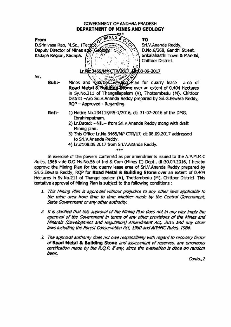
Sub:-
GOVERNMENT OF ANDHRA PRADESH DEPARTMENT OF MINES AND GEOLOGY
TO Sri.V.Ananda Reddy, D.No.6/268, Gandhi Street, Srikalahasthi Town & Mandai, Chittoor District.
Ref:- 1) Notice No.234115/RS-1/2016, dt: 31-07-2016 of the DMG, Ibrahimpatnam.
2) lr.Dated: --NIL-- from Sri.V.Ananda Reddy along with draft Mining plan.
3) This Office lr.No.3465/MP-CTR/17, dt:08.09.2017 addressed to Sri.V.Ananda Reddy.
4) lr.dt:08.09.2017 from Sri.V.Ananda Reddy.
*** In exercise of the powers conferred as per amendments issued to the A.P.M.M.C
Rules, 1966 vide G.O.Ms.No.S6 of Ind & Com (Mines-D) Dept., dt:30.04.2016, I hereby approve the Mining Plan for the quarry lease area of Sri.V.Ananda Reddy prepared by Sri.G.Eswara Reddy, RQP for Road Metal & Building Stone over an extent of 0.404 Hectares In Sy.No.211 of Thangellapalem (V), Thottambedu (M), Chlttoor District. This tentative approval of Mining Plan is subject to the following conditions :
1. This Mining Plan Is approved without prejudice to any other laws applicable to the mine area from time to time whether made by the Central Government, State Government or any other authority.
2. It Is clarified that this approval of the Mining Plan does not in any way imply the approval of the Government in terms of any other provisions of the Mines and Minerals (Development and Regulation) Amendment Act, 2015 and any other laws including the Forest Conservation Act, 1980 and APMMC Rules, 1966.
3. The approval authority does not owe responsibility with regard to recovery factor of Road Metal & Building Stone and assessment of reserves, any erroneous certification made by the R.Q.P. if any, since the evaluation is done on random basis.
Contd.,2

4. The Mining Plan is approved subject to strictly adhering to the relevant Regulations of MMR, 1961 and obtaining prior permission from the Director General Mines Safety whenever and wherever it is required.
5. The applicant/ lessee shall safeguard the structures_ public buildings, roads, railway line, electric line and water bodies exists if any as per regulations 109 & 127 of MMR, 1961.
6. The approval of Mining Plan shall be subjected to vacation of prohibitory orders or notices or determination orders etc., if any issued by the competent authority.
7. The Quantity details towards excavated mineral from the quarry lease is not certified by this approval of the document.
8. The approval authority does not owe responsibility with regard to erroneous certification made by the R.Q.P if any and approval is tenti:Jtive subject to modification of new findings at a later date as per the provisions of Rules in force, since the evaluation is done on random basis.
If anything is found to be concealed as required by the Mines Act In the contents of the approved Mining Plan and the proposal for rectification has not been made or if at later stage the information furnished in the document to be incorrect or misrepresenti:Jtion of facts, the approval shall be revoked with immediate effect.
Yours faithfully, Encl: (2 copies of A.M.P.)
j *' ) .... Deputy Oil'ector of Mines & Geology,
Kadapa Region, KADAPA. Copy submitted to : 1) The Director of Mines & Geology, Ibrahimpatnam for favour of kind information. 2) The Zonal Joint Director of Mines and Geology, Kadapa for favour of kind
information. 3) The Regional Controller of Mines, IBM, Sultan Bazar, Hyderabad for information. 4) The Director of Mines Safety, Hyderabad for favour of kind information.
Copy to the Asst. Director of Mines & Geology, Chittoor along with A.M.P and requested deviation if any noticed is brought to the under signed immediately for taking further action. Copy to Sri.G.Eswara Reddy, D.No.13-2-155-1, Shiridi Nagar, Anantapuram for information.

)
l
)
)
)
J
)
J
)
)
)
)
J
)
MINING PLAN FOR ROAD METAL & BUILDING STONE
OVER AN EXTENT OF 0.404 HECJ:s:;:fM§,'(,-4_0. THANGELLAPALEM(V), fl!.J:IISlrRIICT
ANDHRA l'tuUI.t~l£
(Under Rule 7(A) of A.
ROAD METAL & BUILDING STONE QUARRY BLOCK PERIOD 2013-14 to 2017-18
BALANCE PERIOD 2017-18
FOR
SRI. V.ANAND REDDY, S/0. VENKATA REDDY,
GANDHI STREET, SRIKALAHASTI, CHITTOOR DISTRICT,
ANDHARA PRADESH STATE. CONTACT N0.9848139889
Prepared by
G.ESWAR REDDY M.Sc., B L., RQP / Geologist,
RQP/DMG/AP/ 07 /2014, RQP/HYD/302/2013/A'
D.No.l3-2-155- l , Shirdi Nagar,
ANANTAPURAMU. A.P. 515001. Mobile:09849132789.Phone No:08554 222737.
Email:[email protected]
SEPTEMBER-201 7

This mining plan
Place : Kalahasthi.
Date : 08-09-2017.
DECLARATION
CERTIFICATE
Lessee
v\A~~~ V.ANAND REDDY
This is to certify that Mining Plan in respect of quarry lease applied
area for Road Metal & Building Stone over an extent of 0.404 Hects. in
Sy. No. 211 of Thangellapalem Village, Thottambedu Mandai, Chittoor
District, Andhra Pradesh State, prepared by Dr G.Eswar Reddy, Consultant
Geologist & RQP from M/s. SAl GEO SERVICES , Office at Anantapur.
The Lessee agrees to follow the same in accordance to the provisions of
law.
Place : Kalahasthi.
Date :08-09-2017.
Lessee ,n ,...., . /' ~- UL>/Y
V.ANAND REDDY

/
)
)
CERTIFICATE
The provisions of Granite Conservation and Development Rules 1999 &
Chittoor District, Andhra Pradesh State.
concerned authorities.
Certified that the information provided in the mining plan is correct to the
best of my knowledge.
DATE: 08 ..()9- 2017.
PLACE: ANANTAPURAMU.
SIGNATURE OF THE RQP
( G.ESWAR REDDY) G. ESWAR REDDY, M.Sc.,B.L. Ph.D
Recognised Geologist IBivi/ROP/HYD/302/2013/A
RQP/0\tiG/AP/07/2014
)
f
I (
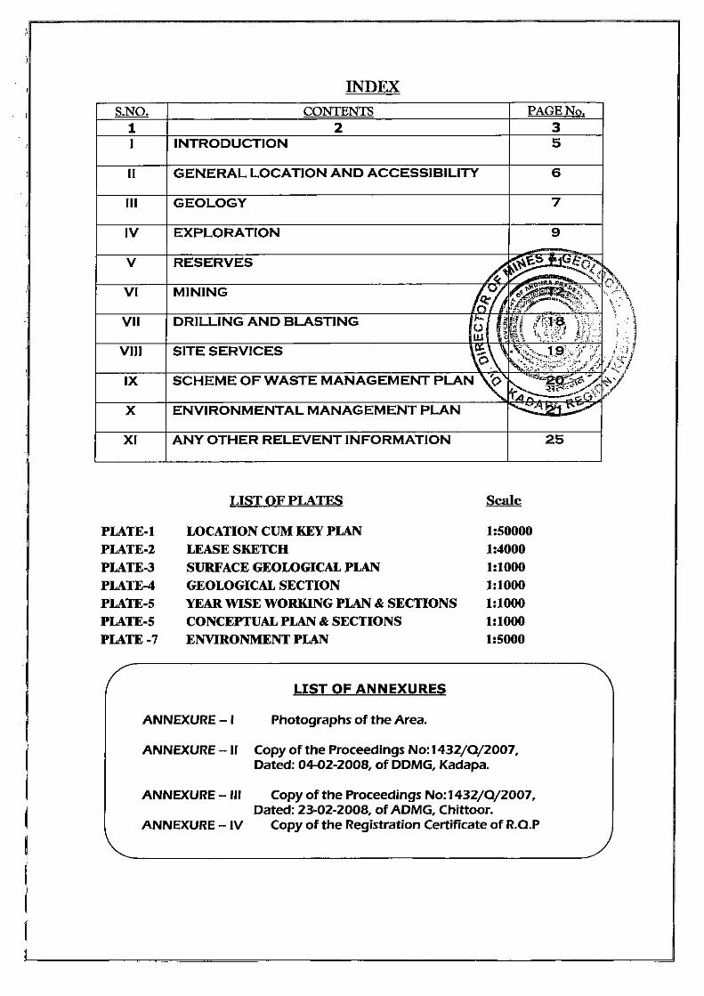
INDEX
S.NO. CONTENTS PAGE No. 1 2 3 I INTRODUCTION 5
II GENERAL LOCATION AND ACCESSIBILITY 6
Ill GEOLOGY 7
IV EXPLORATION 9
v RESERVES ~ ~~"~ft .... "".....::;< s ......,., , ..
VI MINING ~~~ ~~~~,·~ · ~ -~:-~ t'"t:'J•' .:-~ , :-;:\ ~~~
VII DRILLING AND BLASTING /-. {I' ~i·~1::s )frj ~ ~ • ~i $'::" • • , .. . ';. t t: ~~: ~~::1 ;.
VIII SITE SERVICES ~\' .~::·... 1 ~f /:' ".i "~' ~ ....... ~ ..... . :)l·-,l r--· ..
~~~:~ ~:~;;~~;~·: .·.1::: .. :.,f'j5 IX SCHEME OF WASTE MANAGEMENT PLAN ~ ~~ .. ~~'2~~~·->: t: :z;""" / ... ,..4~c(->''· X ENVIRONMENTAL MANAGEMENT PLAN ....... : .. ::.;:,:'-: ~1~
XI ANY OTHER RELEVENT INFORMATION 25
LIST OF PLATES Scale
PLATE-1 LOCATION CUM KEY PLAN 1:50000
PLATE-2 LEASE SKETCH 1:4000
PLATE-3 SURFACE GEOLOGICAL PLAN 1:1000
PLATE-4 GEOLOGICAL SECTION 1:1000
PLATE-5 YEAR WISE WORKING PLAN & SECTIONS 1:1000 PLATE-5 CONCEPTUAL PLAN & SECTIONS 1:1000 PLATE -7 ENVIRONMENT PLAN 1:5000
LIST OF ANNEXURES
ANNEXURE - I Photographs of the Area.
ANNEXURE -II Copy of the Proceedings No: 1432/0/2007, Dated: 04-02-2008, of DDMG, Kadapa.
ANNEXURE - Ill Copy of the Proceedings No: 1432/ 0/2007, Dated: 23-02-2008, of ADMG, Chittoor.
ANNEXURE- IV Copy of the Registration Certificate of R.O.P
~ ,~ ,.t .. \ . \' ' }
1·. :.. .' ..
,- ' ./ ·lt.. -~-;··; ~··

)
)
j
' )
)
\
I )
MINING PLAN FOR ROAD METAL & BUILDING STONE OVER AN EXTENT OF 0 .404 Hect. LOCATED I N SY. NO. 211, THANGELLAPA LEM
Introduction
VILLAGE, THOTTAMBEDU MA NDAL, CHil'Tf0GQing r!ar- is i~;-';.r.;vf:d Subject OTHER THAN FULLY MECHANIZED OPEN CAST QUARRY 'B~P~(i())ly-!o;~s SL~:t;~~tion:; inc1icumd
n11rle J";;rllr:J ,...i::n ,::~pprow~d Letter (UNDER RULE 7(A) OF APMMC'1966) No._2Q!) ~
Date 0 4
Sri.V.Anand Reddy, has filed an application for Q.L. of Road Metal &
Building Stone over an extent of 0.404Ha, in Sy.No.211 of Thangallapalem(V),
Thottambedu(M), Chittoor (Dist.) for 10 years in the office of Assistant Director
of Mines and Geology, Chittoor.
The Assistant Director of
submitted
over an extent of 0.404
Sri.V.Anand Reddy.
After careful examination of the proposals of the ADM&G, Chittoor, the
Deputy Director of Mines and Geology (DDM&G), Kadapa in principle has
decided to grant quarry lease for Road Metal & Building Stone over an extent
J of 0.404Ha, in Sy .No.211 of Thangallapalem(V), Thottambedu(M), Chittoor
)
)
)
)
)
J
)
(Dist.)in favour of Sri.V.Anand Reddy for a period of 10 years under Rule 13(1)
& 15(1) of A.P.M.M.C.Rules, 1966. Vide Procds.No. 1432/Q/2007, Dt:04-02-
2008, DDM&G, Kadapa and the same was executed by the ADM&G, Chittoor on
23-02-2008 Vide Procds.No. 1432/Q/2007, Dt:23-02-2008 ADM&G, Chittoor .
The submission of Mining plan is a pre requisite for quarry lease as per
Rule 7(A) of APMMC Rules, 1966.As per the Notification of the Ministry of
Environment & Forests, Climate Change (MoEF & CC), New Delhi dated: 14 Sep
2006, it is mandatory for all the Mining Projects with lease area of 5.000 Ha
and above irrespective of the mineral (major or minor) to obtain prior
Environmental Clearance (EC) under the provisions thereof. Further, all
Category A and Category 81 projects shall undertake public consultation in
accordance with the above notification . Further the Government of India,
Ministry of Environment & Forest vide office memorandum No. L-- APPROVED
J. ~ ~ ' ',, 1
.~~:SR!MW~~:'\ R:~!.Q} ,," Denut,. :.;'.-~rotc ~ , ".,. ,
i~~ ~~ ;..I..., · ~ O: b'~~~:~;s :..~: · ·· ·""! .~r!"\ ,v_

)
)
)
: I
)
\
"\
)
'
)
)
)
)
)
)
J
)
)
J
)
Mining Plan for Extent: 0.404Ha, Thangellapalem (v)
Road Metal & Building Stone Thottambedu(m), Chittoor (d)
11011/47/2011-IA.II(M), dated 18th May 2012 in order to ensure compliance of
the Honourable Supreme Court dated 27.02.2012 in I.A.12-13 of 2011 in
SLP(C) No. 19628- 19629 of 2009, instruction were issued that all the mining
projects of minor minerals including their renewal, irrespective of the size of the
lease would hence forth require prior Environment Clearance.
Decentralizing the Environmental Clearance (EC) for sustq~le sand
mining and mining of minor minerals, Govt of India MoEF,D~~:~~~ict Environment Impact Assessment Authority (DEIAA) vid ~:~~'f.~~E)):Jat_ed )\~ Jan 2016. This district level authority has the powers to ~J f~,ye tlie ECs forth~
mining of minor minerals for an area less than 5.000 Ha ~ \.~· ....... _ i .. · ,' (.) '\ . . • ~ , .. ,
.;,.... ··.· ·. . . -./ ,.; " As the area of mining in this case is more than 5.00 ·~liP.~tiJe :;lesse~ ~6ai to
'4 D'A~:--,·~·='· ,,~ ,)";,...-'" obtain EC from State Environment Impact Assessment Authonty-.~S"GIA1\), after
the approval of this Mining Plan. In view of the above, the lessee intends to
prepare an Environmental Management Plan for submission for grant of
Environmental Clearance for their proposed 2.270Ha of Road Metal & Building
Stone Quarry lease area, thereby submitting this Mining Plan for necessary
further action which is a pre-requisite for EC.
In this connection, Sri.V.Anand Reddy approached Sri. G.Eswar Reddy,
Consultant Geologist & RQP, to prepare the Quarry Plan following the
prescribed guidelines. Hence, this Mining Plan is being prepared and submitted
under Rule 7 (A) of APMMC' 1966, following the contents of Form-T.
The proposed Mining Plan covers a scientific and systematic assessment
of the deposit which indicates the details of conservation of the deposit and
protection of environment in and around the mining area. The survey comprises
of Topographical Survey, Large Scale Mapping with contours.
The survey enables the Lessee to take up the exploration of Road Metal &
Building Stone in a systematic manner and plan for future expansion
programme.
2

I
1 )
)
. ' "'\
J
)
)
)
)
' )
) '
)
)
)
)
)
Mining Plan for Extent: 0.404Ha, Thangellapalem (v)
Road Metal & Building Stone Thottambedu(m), Chittoor (d)
This Quarry Plan has been prepared taking into account strictly the restrictions to be adopted by the Lessee while conducting quarry operations due to the existence of any structures railway lines, roads, water bodies such as river, lake etc., and the stipulated distances as per the various Regulations prescribed under Metaliferous Mines Regulations, 1961.
The present Quarry plan is being submitted to achieve the proposed production of 15,476 tons of Road Metal & Building Stone during the one-year plan period.
I GENERAL
1.1 Name and Address of the Lessee
Status of the Lessee (Individual/ 1.2
Private Company I Firm) Individual
Mineral {s) which are included in the ROAD METAL & BUILDING 1.3
Letter of Intent STONE
Name and Details of person 1.4
employed for preparing Mining Plan
1.5 E-Mail & Website
1.6 RQP Registration No. & Validity
G.ESWAR REDDY M.Sc., B L., RQP /Geologist, RQP/DMG/ AP/07 /2014, RQP /HYD/302/20 13/ A, D.No.13-2-155-1, Shirdi Nagar, ANANTAPURAMU. A.P. 515001. Mobile:09849132789. Phone No:08554 222737. Email:eswarreddygeologist@gm
ail. com
RQP/DMG/AP/07/2014 &
Valid Up to Dec-2024
3
,
)
)
}
)
)
-)
)
)
)
) I
)
)
)
)
)
)
)
I
)
Mining Plan for Extent : 0.404Ha, Thangellapalem (v)
Road Metal & Building Stone Thottambedu(m), Chittoor (d)
II. LOCATION AND ACCESSIBILITY:
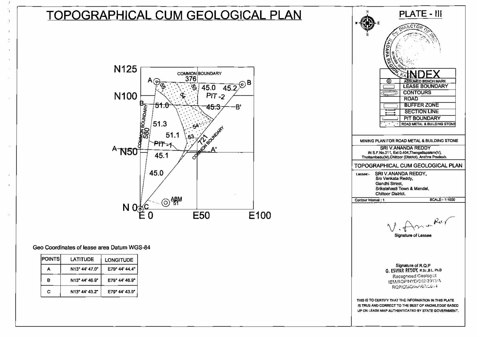
i) Description of the Area: The proposed Quarry Lease area falls on the Survey of India (SOl) Topo sheet No. 57 0/10 .The QL area is located North latitudes 13° 44' 47.0" and East longitudes 79° 44' 44.4" (Plate 1).
1. Toposheet No. with latitude and longitude of all corner boundary pillars: .--~~
The Quarry lease area falls on SOl Toposheet No. 57 9/..~t~~ ~~)~ ordinates of the boundary pillars are tabulated below: , I 0 ° ":: ··:~ , ... ,,\~.:\
Table- GPS READINGS OF BOUNDARY POINTS ?~ ~ .· . . . .. :-.\ , ~. \
A N13 44 47.0 E79 44 44.4 ~ ! \, . · j ~: f
B N13 44 46.9 E79 44 46.9 \"'~ • : . ; '"' <' !.:/);} C N13 44 43.2 E79 44 43.9 ~ +. ·-_.,_.. d .., . ;.,;;?/
'· "'!() .. ·--- ..•• . .)y t ..... -/:: .:• ,. qt· · ' "~
*Map Datum: WGS-84 .......... :~,;, ..... ·
Status of State District Mandai Village Survey No. Extent (Ha)
Site
Andhra Chittoor Thottambedu Thangellapalem 211 0.404 Ha Govt.land
Pradesh
2. Attach a general location map showing area and access routes:
The Quarry Lease area is located 1.25 km away from Thangellapalem village
towards South . The state borders of A.P. and Tamilnadu is 40.00 km and the
Municipal headquarters of Kalahasthi is 5.5km towards West. One can reach the
QL area from Kalahasthi without much hassle. Take Kalahasthi to Naidupeta
Road towards SH 61 from Peddakannali village road and drive a distance of
2.50 km Southwards take left diversion by travelling 2.5km QL area can be
reached . The lease area which is a gently sloping East at the foot of a
pediment.
The Mandai Headquarter Kalahasthi is about 5.50 Kms from the QL area.
The State capital/ Amaravathi is about 650 Kms.
Ill DETAILS OF APPROVED MINING PLAN/ SCHEME OF MINING IF ANY
This is the first Mining plan being submitted.
4

)
1
)
'"'\I
)
')
)
)
)
)
)
)
)
)
)
)
)
)
\
_)
)
)
)
)
')
1.
Mining Plan for
Road Metal & Building Stone
PART- A
GEOLOGY AND EXPLORATION
a. Physiography i) Topography
Extent: 0.404Ha, Thangellapalem (v)
Thottambedu(m), Chittoor {d)
1.1.1. The Quarry Lease area is a gently sloping ground at the foot of a mound in East side of the lease boundary. Ground level is sloping down in East with a gentle relief of 8-lOm. Boundary pillars A have max elevation of SSm MSL whereas the boundary pillars C have the least elevation of Slm MSL. The area is almost flat with an outcrop of a Granite cutting ~~~~~~_i~e&~~~ss
between point A and C. No public roads are passing throup~~~~~!~~~~~ta\ ii) Drainage Pattern 1.~V£·*" l<"::<~.~:_:_· ... o.'-;_,~ "-'1. 0,\
. t J At .. ·;: . ~:~···· '- •:~ , ;. \ ~-- • ,•- J'·~ ; : . \ '.· .. \
1.1.2. The drainage pattern of the Quarry Lease area is d~~~p~ltic in nature. ·~n L~ l northern portion of the lease area is observed two d't;;l~tr.~ams emerg_ifig / ~~-~ from the top of mound and merging into a single stre?J~, anq exiting :fJit~"~~~~ site at on the west side. Water can be seen in these sf~~·~;~·-.<?:~~Y.~:~~p the monsoon season. They will appear dry for the rest of"t'ltl~~ seaso~ .. A
... .... .~ ... .. "'-._,,,p
buffer zone of 15m on either side of these streams has been considered as per the guidelines in Chapter XII, Rule 127(2)(8) of 'Metaliferous Mines Regulations', 1961.
iii) Vegetation The Quarry Lease area has scanty vegetation thin grassy bushes. Thick vegetation is seen only around the existing water bodies like a pond outside the lease plot and a well in the NW corner of the lease area, along the boundaries of stream in the northern side and along the western boundary. Beyond west boundary, farms of mango and other vegetables are present.
iv)Ciimate:
The climate is tropical with temperatures ranging from 350 C to 450 C
in summer and 120 C to 300 C in the winter. The normal annual
rainfall is about 1259.6 mm and in the year 2010-11 1619.0 mm
mostly from NW monsoon.
b. Regional Geology
The area is constituted of different geological formations with the Archaeans
represented by the Granitoid gneisses traversed by basic dykes occupying a
major portion. Overlying the Archaeans unconformably are the B.N.Kandriga
5

)
)
)
)
)
)
)
)
)
) )
)
)
Mining Plan for Extent: 0.404Ha, Thangellapalem (v)
Road Metal & Building Stone Thottambedu(m), Chittoor (d)
constituting the Kambakkam and Nagalapuram hill ranges while Upper
Gondwana formations are represented in the Satyavedu and Allikur hills in
the area to-its south. Laterite fringes covers the Upper Gondwanas. The
Geological succession of the region is given below.
Table 4: General Stratigraphy of the Region:
Period
Recent
Upper Gondwanas
Cuddapahs
A R c H A
E A N s
Group
Dharwars
Soil, sub-soil, alluvi con g I om e r.v.::smo,c
Biotite granitoid gneiss Mica-schist, hornblende-schist, epidiorite,
hornblende and biotite-granulite and talc-quartz-schist
> c. Local Geology
)
_)
)
)
I
)
)
Rocks belonging to Older Metamorphics, Peninsular Gneissic Complex
(PGC) and intrusives like pink granite, epidote-hornblende gneiss, basic
dykes are exposed in the area. Small bands of Older Metamorphics
represented by hornblende biotite granulite occur as enclaves within PGC.
The PGC is represented by biotite-hornblende gneiss with local variation
to hornblende biotite gneiss. Outcrops of PGC are preserved as inselbergs
and ruwares. It shows considerable variation in colour from light grey to
bluish grey and pinkish grey. The banded gneiss is more prevalent in the
area . Fine grained dark layers of biotite and hornblende alternate with
light coloured quartzo feldspathic layers in the banded gneiss.
6
I
)
)
)
')
)
' I
)
)
)
)
)
)
)
)
_)
)
)
)
)
Mining Plan for Extent: 0.404Ha, Thangellapalem (v)
Road Metal & Building Stone Thottambedu(m), Chittoor (d)
Road Metal & Building Stone present in the QL area is actually weathered
Granite/Granite gneiss of Granitoid series. It is friable and easily
crumbles. Physically looks intact but immediately disintegrates when
subject to a gentle shock. Quartz and micaceous minerals being resistant
to weathering remains intact whereas feldspars being susceptible to
weathering have undergone weathering giving rise to the formation of
Road Metal & Building Stone . Road Metal & Building Stone obtained is
leucocratic light pinkish white with clearly visible m·0
· ~ESi ... ~~dium ~ '<o'\
to coarse-grained. Specific gravity of weathered ~ ~if~ ·~f3:t~.- ~ ty !..;;. ·'if··; ~~· \ .
usually ranges between 2.4 to 2.5. An average ~ c ~~~~~:(~ti}Y'Wf-- .. ·I~~ · is considered for fractured Granite in this area . o \. "'.~~' ~--' .-,.,/1,-:;.;} r.1..
• ~'c(.' ~~,.,.:·-~! .. :/:;~ "!:
c) Details of the Prospecting License Holder: N.A. ¢1-4 ~#:' d) Details of the Prospecting carried out: The subject SAl~~ ,arcated
on the ground with reference to Revenue Pillars. Later the topographical survey
of the area was carried out. The ABM (BP-C) is connected to Grid of N 13° 44'
43 .2" & E 79° 44' 43.9" located on the SW of the QL area. Based on
topographical survey and geological features, collected from the surface data,
the surface geological plan is prepared on 1:1000 scale with l.Om contour
interval and enclosed as Plate -3.
e) Surface Plan area on 1:1000 scale: The surface cum Geological Plan and
Cross Sections of the QL is prepared on 1:1000 scale and is enclosed as
Plates-3 &. 4.
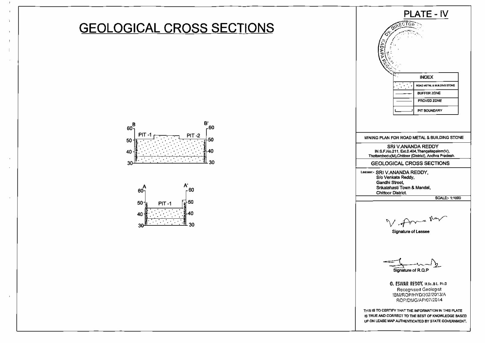
f) Geological plan is enclosed as Plate-3.
g) Geological cross sections have been shown on Plate-4.
h) Future Program of Exploration programme planned in next one year:
As this Quarry Lease is being granted for Road Metal and Building Stone for the
purpose to use as raw material to company own Crusher.
i) Reserves and Resources as per UNFC :
(i) Type of Deposit as per UNFC Guidelines
Road metal and building stone is not failing in any category of UNFC
classification. It is localized mineral available anywhere utilized for
construction purpose such as laying roads, construction of buildings etc.,
7

)
') J
)
' ' }
) ;
)
)
)
)
)
)
)
. )
, )
)
)
\ I
)
)
.I
ii)
Mining Plan for Extent: 0.404Ha, Thangellapalem (v)
Road Metal & Building Stone Thottambedu(m), Chittoor (d)
depending upon the characteristics of the rock. Granites, dolerites etc
which are highly disturbed and dolomites, quartzite etc., which are not
useful for any other their specific purpose of their characteristics in
specified area useful for construction as road metal and building stone as
locally.
Parameter - Grade, Threshold value, Sectional Area and Bulk
Density: "'"'t-ies-.ts."'G·., \'C~I$'~
~-0/'~~~~~~ --~~<;). As t~~ ROM is intended for us~ in the Road metal a. (~·JBt.~~~~~!r~~~~~~~\~~\ spec1f1c parameters were considered . The bulk denl~~ ~f_2.~ : ~-s~:a~~pte~ ·. \ for estimating the reserves. ~.\ \.:;.~.-~ ·":<; ~~IJ)JI jz-1 j
.,,~~ . ;>..:'> ~. •· ... ~ - ~· • • ,
The sectional area was considered and assumed thic ~ne ~:&2~-~~;:;~t~t '~ 1.) ~~~-... .; ~\' •
and 50 m on either side of the leased area. The Bu"1~~~j,y~t(as considered at 2. 5.
ii) Status of exploration : G1
GEOLOGICAL AXIS:
1. Geological Survey:
i) Mapping: Detailed geological survey was carried out in the applied
area on 1:1000 scale with l.Ometer contour interval.
ii) Preparation of detailed topographical cum Geological map : The
topographical cum Geological map including all surface Geological
features, extent of deposit, structures, have been prepared on 1:1000
scale duly marked with surface geological features, GCP's etc. (Piate-3).
iii) Topo grid 1 Triangulation stations: The topo grid with Geological
cross sections has been prepared on prescribed scale showing litho-units.
Relevant plans are enclosed as Plate-3.
2. Geo-Chemical Survey: Geo Chemical survey is not warranted. The
suitability for aggregates was tested .
8

)
)
)
)
J )
-,
)
)
)
"')
)
)
)
)
)
)
')
)
)
)
)
Mining Plan for Extent: 0.404Ha, Thangellapalem (v)
Road Metal & Building Stone Thottambedu{m), Chittoor (d)
3. Geophysical survey: Not carried out because sheet rock of Granite is
exposed on surface itself.
4. Technological survey: Not applicable.
• Detailed topographical and geological survey was carried out on 1:1000
scale showing all the surface features, contours at l.Om interval, the lease
boundary, surface Geology & Structural features.
• The entire thickness of Road metal & Building stone found to be more
• Reserves are estimated by cross section method
FEASIBILITY AXIS:
be referred to.
2. Mining:
Road Metal and Building stone will be exploited through opencast other than
fully mechanized mining methods with drilling & Blasting. ROM will be
directly consumed by the Lessee for the crushing plant and intended for the
highways Project from Kalahasthi to Chennai and Tirupati. The Lessee has
already established the crusher and hot mix plant adjacent to the proposed
quarry lease area.
3. Environment:
The deposit will be mined adopting conventional opencast semi-mechanized
mining methods without any adverse environmental impact. The Lessee will
obtain statutory clearances as soon as this Mining Plan is approved. Mining
in the leasehold does not disturb any human settlements as they are far
away from the lease area. On the other hand the mining operations will
create livelihood to the villagers nearby. The Lessee will develop green belt
around the QL area as part of his commitment to environment protection.
9

)
M ining Plan for Extent: 0.404Ha, Thangellapalem (v)
Road Metal & Building Stone Thottambedu(m), Chittoor (d)
4. Processing:
After blasting the ROM will be fed directly on to the crusher for crushing in to
desired sizes of aggregates. The crusher is already in place outside the
'J proposed quarry lease area.
)
Mining operations will be carried out by deploying the following machinery:
S.No Type of machine Nos Dia of hole Size/ Make (inches) capacity
1 Excavator /JCB 2 - 1.2 cum L&T
2 Tippers 4 - 17 tons -3 Drilling machines 1 3" ~ 4 Tractor mounted 2 2" 'Lit
a:: compressors ::: 5 Water Tankers 2
l -
\~ 6 Loaders 2 3cu m \
Motive power
~
H-~
~{)~~~~ -~'- I, e .. }~.,. Yt~~~~i%"~ .. W!;~~ ..... ~ ... ..,.
rt.:,' rDiese~~ V' > I '< • ~ S g\~ f ~~ ... ._ / f :;
'\ • 'f '' ,ai !:'I J •. ...... } •
"'• ~. 1; : \ ';,o, I ~-' ,,-,_,..",<:
r, ".,; ...... ·;...:.:·-~· .(:/'! /,
~~;{
H.P
~00
i~
:'~' ~ f.l":
~-) \. t, ~: s \
:!j )._C.-.f <:;
:1.. r._.., :
~~} ~-
i }
5. Infrastructure: The entire necessary infrastructure~ &:~e, r est
shelter, magazine, explosive van, water tankers, power connection etc., will
be provided once the mining plan is approved. The QL area is connected with
) roads to the Mandai and District headquarters.
)
)
)
)
6. Costing: The cost of production of Road Metal & Building Stone works out
to be Rs. 250/- per ton.
7. Marketing: Road Metal and Building stone is not intended for outside
sale. It is for captive purpose for the crusher and Hot mix plant
intended to put for use in the Highways road project from
Thottambedu to Tirupati in Chittoor District.
8. Economic Viability: As the proposed quarry lease is in the near vicinity
and captive use it is surely economic and viable.
9. Other factors: Relevant clearances shall be obtained for continuing the
mining operations in the QL area .
ECONOMIC AXIS:
1) Detailed exploration:
10
)
)
)
)
Mining Plan for Extent: 0.404Ha, Thangellapalem (v)
Road Metal & Building Stone Thottambedu(m), Ch ittoor (d)
Detailed topographic survey and geological mapping the applied QL area was
subjected to detailed exploration by f ield traverses and well inventory data.
The depth of sheet rock is assessed by the litho log observed in the boreholes
of agricultural lands.
2) Mining Reports/Mining Plan
This is the first Mining plan being submitted.
3) Specific end-use grades of reserves (above economic cu ~grade) NES &~··
ROM is intended for crushing to use in the aggregates fo G> ~ .... ~~6' ~ ~?;r111n 1"~~Y~
4) Specific knowledge of forest/non-forest and ot 0 1art~S~~~ti~~·t~··~~-\
LL/ ·" ..... , I I • 1 • 'c
The entire applied QL area is covered by Govern men 51f mc;i"~ . .., (J~iptJ~J ~tate }
Forest Boundary is 12.0km East of the ~L area. Th ·~\t~,r~~~~;,:~·:~~~~td,.~ry between Andhra Pradesh and Tamilanadu rs 40 Kms So f~Qht~;{cprp!?o~ed
._)A~r'·~~'.,JI 'S:'~' P ~L P E r,:,\'•J ,..~~·
Quarry lease area. Hence, considering the above paramet:~.r.s;,;::clscussed
reserves 1 resources are categorized as E-1 Axis.
(j) Feasibility Report along with financial analysis per economic
viability of the deposit: The cost of production of road metal and building
stone is arrived at Rs250/- per tonne inclusive of taxes and royalty. The
entire ROM is for only captive purpose as such it is surely economic and profit
oriented.
(k) RESERVES
(i) Mode of Mining, recovery Factor, Mining Losses, Processing Losses etc.,
Road Metal and Building stone will be mining by open cast other than fully
mechanized method with drilling and blasting. The recovery factor is
considered as 95°/o with 05°/o interstitial voids and fractures. There will not be
any mining losses excepting handling loss which will be again recovered
during further loading.
(ii) Cut off grade and Ultimate Pit depth: There is no cut off grade as the
ROM will be put to use for road metal as aggregates. The UPL will be SOm at
11
Mining Plan for Extent: 0.404Ha, Thangellapalem (v)
) Road Metal & Building Stone Thottambedu(m), Chittoor (d)
) the western portion of the applied QL area during the 1st year of this mining
) plan period.
)
)
)
\ ,_.
)
)
(iii) Mineral blocked due to the presence of I maintenance of benches,
barriers, internal roads, electrical lines etc,: The mineral will be blocked
in 7 .Sm safety barrier zone, Roads, Benches which is computed separately
and tabulated in the succeeding paragraphs.
(iv) Total Mineral reserves: ·~~ ·f iN\h'tC.;o & ,;_ •. ,,
The reserves are estimated basing field traverses and th . git~~~1'0ell ;.:::'/ /( ... ,~ ..... , .. , .... """'' '"'~ .• ~"•\
inventory in the adjacent agricultural fields and cross {!f<l1::~~;~~)~f~}ff~t·9h \ti~\ ore body. The area of the influence and the cross sectidf~' vvt~~}ake~. a.t 20. mJ on an average i.e. 25 m on either side of the Cross secrtfn; tQ_e~ o~~YT~~.nc.e .of
the Granitoid gneiss is more than 60.0 m BGL. Based o~)e.~!~~~t~~s and correlated data from the boreholes in the adjacent agri~~~r§f~£ to a
depth of lSO.Om, the estimated reserves are considered as Proved reserves.
The cross sections A-A' & B-B' are considered for computation of reserves.
The present area which is explored is considered for computation of reserves
) under G- 1 category.
)
)
)
)
)
)
)
)
)
Production
Sectional Deposit Volume
RESERVES RESERVES
Category Sections Height OF OF Area m3 AGGREGATE AGGREGATE in m @ 95% IN @ 2.5/m3 IN
m3 Tons
1851 17 31467 29894 74734 Proved A-A'
29894 31467 74734
2189 18 39402 37432 93580 Proved B-B' 37432 39402 93580
Total 4040 70869 67326 168314 . Geological Reserves of Road Metal & Building Stone = 168314Tons
Net Reserves available for Mining after Bench Slope Deduction = 168314 Tons
Total Mined /excavated in The Q.L. Area = 7435 Tons
Net Minable Reserves of road metal & building stone = total reserves
depleted minerals = 168314 - 7435 = 160879 tons
Rock Waste@ 5% in m3
1573 1573 1970 1970 3543
12

)
)
)
)
)
)
)
)
\
)
)
)
)
Mining Plan for Extent: 0.404Ha, Thangellapalem (v)
Road Metal & Building Stone Thottambedu(m), Chittoor (d)
Mineral already excavated in QL area
S.No Year Quantity in CBM Tons
1 2008-09 216 540
2 2009-10 NIL NIL
3 2010-11 204 510
4 2011-12 204 510
5 2012-13 NIL NIL
6 2013-14 600 1500
7 2014-15 300 750
8 2015-16 1200 3000
9 2016-17 250 625
Total 2974 . 4 , 7435 ... ·~-
~\ '- -4' -
~.,· '\ c • ., ." ~~ ""'. LIFE OF THE MINE:-
/.., "· ~;:
~ • * • . ~ ff/;:l!j ~ ' \-·: fl r r. .. • • ...... Net Mineable reserves/ Average yearly production=16087.9 ! /15476= r1 1) }:: • -:.' I ,._ .. ~
3.0 MINING
" • ' ·,.. I
C> •• . ·~- w-i . ~Q.4 years . . ,.. /."·: • ,~ '·· ,.,,.... _.,, .. ,. . Co/. • -.) ' 't .. , ;,..... ., .. ··/. ·~· L ~:<·· I) ....... : <-1..,7,,"/;1. ",......-; ~-'
~-··-(· 'N,' /' • ,a r:-. ••. G\0~ .. # -. ,~ c ~
I
(i) OPEN CAST MINING METHOD (Mining Carried out)
i) This is running quarry. The proposed mining will be carried out by opencast
other than fully mechanized mining method with drilling and blasting. The ROM
will be sized and sorted in the crusher established outside the quarry lease area
and loaded on to tippers and tractors using JCB. Mining will be carried out by
formation of benches of height 6 mts. The details and sections are depicted on
Plate-4.
(ii) Year wise tentative excavation in Cubic Meters indicating
development, ROM, Pit wise: About 1086m2 of excavation out of which
intended ROM 6516 tons of Road Metal & Building Stone will be mined by
forming One bench of 6.0 m. The year wise details are tabulated below:
13

)
)
)
)
)
)
)
)
)
)
Mining Plan for Extent: 0.404Ha, Thangellapalem (v)
Road Metal & Building Stone Thottambedu(m), Chittoor (d)
PRODUCTION Working Bench Volume RESERVES RESERVES Rock
Year areas height m3 OF OF Waste@ m2 m AGGREGATE AGGREGATE
5% in @ 95% IN @ 2.5/ m3 m3 in Tons m3
1st year 1086 6 6516 6190 15476 310 (2017-18) 1086 6516 6190 15476 310
GRAND TOTAL 6516 6190 15476 310
1st year : During first year operations it is proposed to dev~J9.f=r:ltR~t~"'9-[.king pit /' .. , __ , ~ .. ,; {;- .,:, .
J'!C. ~.-4.. ' .•. 4''"'>
Western end by covering the face into one bench of 6m ,height-wirt:t:~t<~:t:::t.o RL " , . ., .. /, /. .. ,. . · ... , ·•·•
45 m. The workings will be carried out over an area of 1iJ)86r'l:1{. · -r~-~ ~~~~-~6.n;:~~ ill ft::.·.. ... . . ~ .. : l,:t' ~~
be oriented in East direction and obtained about 6190 ,fi~ fo~ 15476.tor,i,s .of Road . . \r.,\·:··_,·· . ... ·.· .. ·.·:_···./.'-. ...
metal and 310m3 of waste m th1s year. ...- ·\ ·..;:._,,··: --.: ·.>'·-' . ./ f::1 ,·
\~!6·::·· .. 5.:~~;:}:·:~:;~;~;:_{;~-:./ (iii) Dump Management: There is no proposal for d lmj_pq·a,s·:7f;:'~~:t~>is not
.-. .. ~,;..~~AH;~/,1
anticipated and only interstitial voids and joints are expected in the sheet rock
formation.
Lay out of Mine Workings, pits, roads, etc.
The Lessee intends to extract Road Metal and Building Stone production to the
tune of 6190m3 or 15476 tons of road metal and building stone during the
Mining Plan period.
During this period, it is proposed to exploit the road metal from the total area
of 1086m2 to an average depth of 6m over the lease area from East to West
RL 51 to RL 45 m as shown on Plate 5.
There is no problem in the quality of Road Metal & Building Stone which
confirms to the specifications Aggregates (Annexure -IV) .
The Lessee proposes to carry out mining by opencast other than fully
mechanized method with drilling and blasting . The mineral will be sized and
sorted in crusher for desired size separation . Trucks I tippers will be deployed
for transportation Plate- 5.
1.1 Drilling and Blasting: Drilling and blasting plays an important role for extraction Rom of
14
Mining Plan for Extent: 0.404Ha, Thangellapalem (v)
> Road Metal & Build ing Stone Thottambedu(m), Chittoor (d)
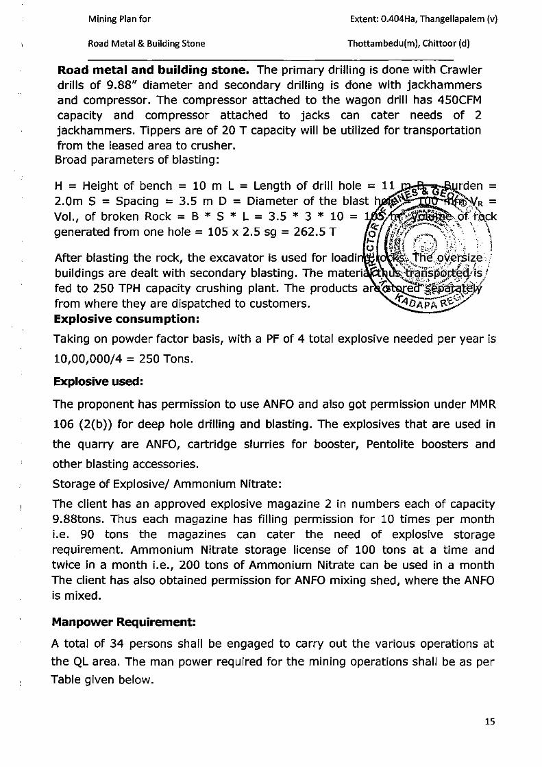
.v Road metal and building stone. The primary drilling is done with Crawler drills of 9.88" diameter and secondary drilling is done with jackhammers and compressor. The compressor attached to the wagon drill has 450CFM capacity and compressor attached to jacks can cater needs of 2 jackhammers. Tippers are of 20 T capacity will be utilized for transportation from the leased area to crusher.
)
Broad parameters of blasting:
H = Height of bench = 10 m L = Length of drill hole = 11 ~s · , G€" .~den = 2.0m S = Spacing = 3.5 m D = Diameter of the blast ~ .. ~ • i-B~VR =
~~ • 1 V1 A P"· ·~,. t ;'l;\ Vol., of broken Rock = B * S * L = 3.5 * 3 * 10 = 1 ~ ,..: ~~JJ~~':;.ofi r.~.ck
r.'t: ~:·r.~;f- ~~·., ' "· l \ generated from one hole = 105 x 2.5 sg = 262.5 T o ;/\'!-"/ ·'""'' \·~-,(~ ' '. 1 After blasting the rock, the excavator is used for load in t; o ~:,.J~~~9~~~~~')~~ ) buildings are dealt wit.h secon~ary blasting. The materi . ·s~~~--~~E:~0~.9-~ i.~/ fed to 250 TPH capac1ty crushmg plant. The products ar ~ _ eet'·.~~.JD_?~l~I·Y from where they are dispatched to customers. ~4DAP~:·\:t'E-0/ Explosive consumption:
Taking on powder factor basis, with a PF of 4 total explosive needed per year is
10,00,000/4 = 250 Tons.
Explosive used:
The proponent has permission to use ANFO and also got permission under MMR
106 (2(b)) for deep hole drilling and blasting . The explosives that are used in
the quarry are ANFO, cartridge slurries for booster, Pentolite boosters and
> other blasting accessories.
> Storage of Explosive/ Ammonium Nitrate:
The client has an approved explosive magazine 2 in numbers each of capacity 9.88tons. Thus each magazine has filling permission for 10 times per month i.e. 90 tons the magazines can cater the need of explosive storage
7 requirement. Ammonium Nitrate storage license of 100 tons at a time and twice in a month i.e., 200 tons of Ammonium Nitrate can be used in a month The client has also obtained permission for ANFO mixing shed, where the ANFO is mixed.
)
)
)
Manpower Requirement:
A total of 34 persons shall be engaged to carry out the various operations at
the QL area . The man power required for the mining operations shall be as per
Table given below.
15

>
'\ • .J
}
)
'
)
>
)
)
Mining Plan for Extent: 0.404Ha, Thangellapalem (v)
Road Metal & Building Stone Thottambedu(m), Chittoor (d)
Category Numoer
First class, Second class managers, and foreman & l Mininq mate
Supervisors l
Excavator & Tipper operators L
Helpers b
Crushing operations 4
Garrage staff L
Drill operators b
Compressor operators L _A\~t:.~~ Gl~ Unskilled labours lULoY~"~HRA·;;;," ~·')
Deployment of Machinery £o/ fA~·:;~:~.;,;_{}:··.·\·.-~. f.... .:;," ." .•• . • (,)I ""fo' .. 0: . ..:., .,
~
·\ The mining machinery and equipment proposed to be depll ~~q ~p ;th~ min~ !
for different mi~ing operations during the Scheme period a~~ri,be~-.in:·~· :. ;.. the table below. o ....... " ·'. _.:!,.,··.-;-.·-~ ... · ••
Details of Mining Machinery Required t',q0~ ~i~?:c>~~---. Purpose Type of machinery Capacity & Nos.
....... - ~ . .!: ....... _.,. .-..... ~
1. Breaking Crawler drill 4.5" 100 mm dia 450 Atlascapco I cfm I 2 nos. CP
2. Loading Loader I Excavator 2 no.
3. Haulage Tippers 25- tonner, 6nos
4. Water Tractor type tanker 1 no
a) Conceptual Mine Planning: The worked out pit will occupy an area of
1086m2 or 0.1086 Hectares to a depth of 6m reaching 45 m (FRL) at the
western portion of the quarry lease area. The area occupied by internal
roads would be 0.010 Hectares, while plantation will not be occupying
because of common boundary around the QL Area . The Conceptual plan
with Sections is enclosed as Plates 6 .
(b) UNDERGROUND MINING: NOT APPLICABLE.
16
\ J I
tl I

1 Mining Plan for Extent: 0.404Ha, Thangellapalem (v)
) Road Metal & Building Stone Thottambedu(m), Chittoor (d)
' ) 4.0 MINE DRAINAGE
)
a) The QL area is over an elevated mound to a height of 18.0m above ground
\ level. Rain water constitutes the drainage system of the area . Normal course of
) drainage is a sheet wash over lower reaches and flows through the seasonal
nala located on south of applied QL Area . Groundwater level is observed to be
ranging in depth from 50-60 m bgl in the nearby agricultural fields.
)
)
)
)
)
~~-
b) The maximum height of the working level is 64 m whi ~ \~rf.f~"iJl-.,!evel Y: ~!Jl~llA iV!~).. '• · \.
of working would be 64 m. o r #..:~~::~i-~r.·:;_. · .. " lk~t;;~r· ··t·... • • ,
0 q :.· '"" ,' ,; ... " ' c) Quantity and Quality of Water: The quality and qu - ~tf, ~dt w'ater cannot qe
estimated as the mine workings are at much higher le ~~s \~f the groundwater
table. However, the water is tasted in the nearby ag f~~t~ral ·field and the ·<}~ ,'
quality of water is found to be potable. ~
d) The entire applied QL area is over a sloping terrain and only sheet wash is
anticipated during monsoon in the applied QL area. Regional drainage pattern is
observed to be dendritic to sub-dendritic in nature.
5.0 STACKING OF MINERAL REJECTS, SUB-GRADE & DISPOSAL OF WASTE
There is no mineral reject or sub-grade mineral in this quarry. However, about
10°/o interstitial voids and intercalated waste is anticipated which is computed
separately. This will be utilized for the formation of internal roads and balance
utilized to form a barrier all along the 7.5m buffer zone of the QL area to a
height of 2.0m.
6.0 USE OF MINERAL & MINERAL REJECTS
The ROM will be fed in to the crusher established outside the applied QL
area where it will be crushed to desired sizes and utilized for the State Highway
project from Kalahasthi, Thottambedu to Chittoor. Entire ROM is intended for
captive consumption .
7.0 PROCESSING OF ROM & MINERAL REJECTS
---------------------------------------------------------- - -In this area ROM will be sized and sorted in crusher for road meta l and
input to hot mix plant . There is no Minera l Rej ect from this Quarry.
17

}
)
)
\
)
)
)
'
J
\
)
Mining Plan for Extent: 0.404Ha, Thangellapalem (v)
Road Metal & Building Stone Thottambedu(m), Chittoor (d)
8.0 OTHERS
a) SITE SERVICES: Site services such as office Room cum First Aid, Separate
Shelter and toilets for Gents & Ladies will be provided at the applied QL area.
b) EMPLOYMENT POTENTIAL:
The human resources deployed are as follows:
S.No. No's
1. Second Class Mines
1 Mana er
2. Mine Su ervisors 1
3. Skilled & Unskilled 10
Labour 5. Watch Men 2 6. Foreman 1 7. Drivers 6
18

)
)
)
)
'\
\ I
)
>
)
Mining Plan for Extent: 0.404Ha, Thangellapalem (v)
Road Metal & Building Stone Thottambedu(m), Chittoor (d)
PART-B
PROGRESSIVE MINE CLOSURE PLAN UNDER RULE 23 OF MCDR' 1988
1. ENVIRONMENT BASE LINE INFORMATION
a) Existing Land use Pattern: The QL area is a barren land. An area of about
1086 m2 will be broken to win the mineral. An area of 225m2 is proposed for
afforestation. The QL area is a barren land and surrounding area Uthabudi RF is
in the North East and agricultural lands to the west and south . (Plate-S )
S. VILLAGE Direction DISTANCE No.
1 Thangellapalem North 0.7
2 Sambayyapalem NW 1.5
3 Srikalahasti West 4.6 65000
4 Thangellapalem SE 1.7 1500
5 Thottambedu sw 2.5 2500
6 Kallipudi North 4.0 800
c) Public buildings, Places of Worship and Monuments: No buildings or
places and Monuments are witnessed in the QL Area.
d) Indicate any Sanctuary is located in the vicinity of the leasehold:
No Sanctuary, eco-sensitive areas etc. are located in the vicinity of the
leasehold.
2. ENVIRONMENTAL IMPACT ASSESSMENT:
(a) Land Area Degraded: An area of about 1086 m2 will be degraded for the working pit; and Roads 150 m2
•
J (b) Air Quality: Road metal & Building Stone mining do to some extent generates dust during drilling and blasting . This would be minimized by usage of moist clay, sprinkling of water at blasting site and haulage roads. Masks,
) earplugs and safety goggles will be provided to the workmen at mine to avoid the negative impacts of dust arising.
19

. )
)
')
)
)
)
)
)
)
)
)
)
Mining Plan for Extent: 0.404Ha, Thangellapalem (v)
Road Metal & Building Stone Thottambedu(m), Chittoor (d)
(c) Water Quality: The subject area is far from industries and as such water is not polluted. The water drawn from bore wells will be supplied to workmen for drinking .
(d) Noise Levels: The QL Area is quite far from the habitation area situated 1.0 Kms away from Thangellapalem Village. Noise is anticipated from drilling, blasting and movement of vehicles. As the quantum of mining is on a small scale the noise generation would be well within the limits. Therefore, the noise pollution is expected to be negligible in the area. However, the Lessee will take all precautions during drilling and blasting by providing muff~lers. ~
~.1(~~~ (e) Vi~r.ation Levels due to Blasting: .As the propos UJ:;;~l~:i!}~~X:~~ep hole dnllmg to some extent and mostly wrth tractor mo., ... ~9!<.~9fl1RF.~ssor ·a'nd blasting the vibration levels will be maintained to be wit wit,~~· !i'f'D!ts. '· . \
(f) Water Regime: Mining of road metal will be carri ffi.b~t_-on top portion of the mound in the QL area to a depth of 10.0 m and i ~ clQ~.e:d environment limited to working pit. The mining ~ctivity proposed wolft{lt 9..t .. ):PF~~~;ct -~ater table of the area. The water table rs observed to be 40-SO~;IJl 1~1;l~: a.dJacent boreholes of agricultural lands. ~-..qy"~~
(g) Acid Mine Drainage: Not applicable.
(h) Surface subsidence: There will not be any surface subsidence as all the benches and ramp ways will be thoroughly rolled for hard surface.
(i) Socio Economics: Mining of road metal and building stone will create some employment opportunities to local villagers thereby generating income and improvement in livelihood of local villagers and revenue to Government by way of paying royalty.
(j) Historical Monuments: No Historical monuments are located near and around the QL area.
(k) Bio-diversity: The slopes of the subject area consist of scattered bushes. There is no report of existence of wild animals in this region.
3. Progressive Reclamation Plan: Mining activity will be carried out ti ll the
completion of state highway project and the worked out pit will be protected
with barbed wire and the mined out pit will be used as storage water pit.
Hence, Progressive reclamation is not studied and will be planned in the first
scheme of mining.
4. Mined out Land: No mined out land will be formed during this Plan period
as mineral is existing much below the proposed workings during this plan
period .
20

J
. )
)
)
)
}
]
l f
)
)
)
)
)
)
J
)
Mining Plan for Extent: 0.404Ha, Thangellapalem (v)
Road Metal & Building Stone Thottambedu(m), Chittoor (d)
Proposed for reclamation of land affected by quarrying activity during and at
the end of mining
No reclamation is envisaged in the life of the quarry as there are adjacent
quarries that are operation. This point will be dealt while the cluster guidelines are
received. Hence, no reclamation proposals are made.
Plantation Programme :
The quarry lease area is scanty suitable for plantation as most of area is rocky.
There are chances of tree growing in the North side of the quarry applied area.
However it is proposed to plant a few trees in the North side of t.Ft(((fi[J':~~ of
quarry applied area. It is also proposed to plant a few trees near · ~· 0g/~~~~te~: .. ;i'ff.tli "e\ ·J '.....:,~ ff\'~,./( ~ 1<1' , 1 ;..,b '-,•.~' I! #, .. ,''· ' J Af/r~;·; 4'-.Ju · ·-·,. ,- :. '
place shown by the village panchayat. The details of propose~ !Ja~l:atio,? -~~-e 1show·
below. 0 \ C·. _ _. ~ ·: ", · ._ .·. n · .
j I
Year
1st Year
2"d Year
3rd Year
4th Year
5th Year
Total
Details of Year wise Plantation Plar~ 't;,\ \~:,_;·_ . · .. . · Planned Location of
Plantation Plantation
Five in buffer & Five in 10
village or road sides
10 Five in buffer & Five in village or road sides
10 Five in buffer & Five in
village or road sides
10 Five in buffer & Five in
village or road sides
10 Five in buffer & Five in village or road sides
50 Five in buffer & Five in
village or road sides
TypeofP~ {.;4: . ,
Neem, or Mango, or Peepal
Neem, or Mango, or Peepal
Neem, or Mango, or Peepal
Neem, or Mango, or Peepal
Neem, or Mango, or Peepal
Neem, or Mango, or Peepal
. v.. ' . ... ·l, . -··' .
>tRe'marl(s. c •
:;-..... :,:_::~,.,~-~:~,,- j ·. ~- ,~
-~
·"' I'
.>A c:t ;;·. C/'•'<.J.:,_. ~:c..-,Hn.-.tr1 -._,..
50% of survival is envisaged.
All around the quarry that is in the buffer/safety zone of 7.5 meters as per AP
PCB and MOEF rules, around the quarry attempts will be made to grow plants with
local arrangement of drums filled with mud. Thus it is envisaged that around 10
plants will be planted and taken care of in one year. Thus the area available around
the periphery will be sufficient for around 10 years.
Although the area in general is fertile the location where the quarry is situated is
totally rocky. Expect for some wild growing medium sized plants that grow in the
cracks of boulders; there are no notable species in the area. However trees like
Neem, Ashoka, Mango, and loca l species Peepal are found in and around. Therefore
21
I ,

. )
)
)
)
' }
)
)
)
)
)
)
)
)
)
)
' )
)
)
)
\ )
)
)
)
Mining Plan for Extent: 0.404Ha, Thangellapalem {v)
Road Metal & Building Stone Thottambedu(m), Chittoor (d)
these three species are planned for plantation. Maintenance of these plants that are
grown in the buffer zone will be taken care by the quarry management . The plants
that will be grown in the village will be taken care by the management, in
coordination with the panchayat members.
5. Top Soil Management: There is no top soil generation from the applied QL
area as such management does not arise.
6. Tailing Dam Management: No tailing dam is required~~ ~wfES'·e-........ . o~.._.c,:~-
7. Disaster Management and Risk Assessment: Ink·~<l-s~-af~~::·~J~}rt9 )j~es not involve disaster of land etc., except degradatior~CDf~,.la_nd_.· , .N~6,Jioodf~~, subsidence, land slide occur in the region . The Mine~o.~afl·ager wiiL,take; the
\ \\:_. . . . . "b'l 't. th t f t d" "d t \'\.,. , . . ' ' respons1 1 1 y rn e even o any un owar rnc1 en . ·-.<_< > ': ·:·:. ....... .. , ,
Disasters are possible in an industry like mining~~~,~~~§~6.~~;1~fi;i{j,~{ of "1 F: t··{·. ~ .Y: ..,
... , ....... ~1: -.,;~.~·J',. ... -r occurrence of some of incidents are tabulated below. ,
Table 18: Probability Table for Disasters of Operations planned on 100 Point Scale.
51. Type of Disaster Exposure Severity Frequency Risk No. Index Index Index Numeric
1 2 3 4 5
6
Mining injuries so 100 0.1 500 Land slides 10 100 0.01 10 Inundation 100 100 0.0001 1 Fire accidents 10 40 0.01 4 Floods & 100 100 0 .00001 0.1 epidemics Animal and reptile 1 10 0.0001 0.001 attack
To meet with any kind of emergency on or off the site, risks are assessed
in advance and a Risk Assessment plan is prepared. Assessing the
possible hazards and planning the procedures to be followed in case of
emergency will reduce the intensity of impact.
Proper bench design in mine and observing all kind of safety measures,
usage of proper PPE on site, attentiveness of the work force on site,
following pre-defined traffic rules by all the people on site are some of the
measures to be followed to reduce accidents on site. Proper care in
22
) /
)
)
)
)
)
)
)
)
)
)
)
)
)
)
J )
)
)
.)
)
)
Mining Plan for Extent : 0.404Ha, Thangellapalem (v)
Road Metal & Building Stone Thottambedu(m), Chittoor (d)
storage and handling of hazardous materials, fuels is also necessary.
Proper communication is key factor in minimizing the accidents on site.
Safety of all working personnel will be the utmost priority of the lessee.
Lessee will provide all the site personnel with necessary PPE like, hard
hats, safety goggles, earplugs, dust masks etc.
To meet any kind of emergency, readiness to s -~~· d to the <Cz::::.:.:~, 4~
nearest hospital is necessary. All mining person ~~iH·"ee :'matsie\.a are of
the emergency phone numbers of the near ~~~~;~~i2 1,;(~~~'1ging personnel will take the responsibility of taking ~~:./Pj\ured immediately to
1 (.'. ~\ •-:
the hospital in case of any accident. A few oft ·t;~ :·personnel should be ·~ ~ -. .
provided first aid training besides the presence
aid kit.
~'lf~:ll.- maintained first J "l -..::...;;..,;_.,....,, ..
Municipal headquarters of Thottambedu is at a distance of 2.00 km from
the lease area, which have all kind of healthcare facilities starting from
primary health care to corporate hospitals. In case of emergency AP state
government's 108 emergency medical vans are available for service.
Apart from this, a pickup with driver will always be available on site to
meet with emergency.
In event of any emergency the Contact person is:
SRI. V.ANAND REDDY, S/0. VENKATA REDDY, GANDHI STREET, SRIKALAHASTI, CHITTOOR DISTRICT, ANDHARA PRADESH STATE.
CONTACT N0.9848139889
8. Care and Maintenance during temporary discontinuance:
An emergency plan to deal with the situation of temporary discontinuance
or incomplete programme due to court order I due to statutory requirements or
any other unforeseen circumstance will be drawn by the techn ica l and
managerial person to suit the specific situation of this mine. This would be
reviewed and modified to suit changing conditions and needs. This wou ld take
23
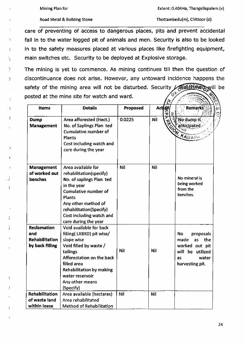
Mining Plan for Extent: 0.404Ha, Thangellapalem (v)
) Road Metal & Building Stone Thottambedu(m), Chittoor (d)
) care of preventing of access to dangerous places, pits and prevent accidental
-) fall in to the water logged pit of animals and men. Security is also to be looked
) in to the safety measures placed at various places like firefighting equipment,
) main switches etc. Security to be deployed at Explosive storage.
) The mining is yet to commence. As mining continues till then the question of
"') discontinuance does not arise. However, any untoward incidence happens the
)
)
)
)
)
)
)
)
-)
)
)
)
)
)
)
)
.)
)
)
)
safety of the mining area will not be disturbed.
posted at the mine site for watch and ward .
Items Details Proposed
Dump Area afforested (Hect.) 0.0225 Management No. of Saplings Plan ted
Cumulative number of Plants
Management of worked out benches
Reclamation and Rehabilitation by back filling
Cost including watch and care during the year
Area available for rehabilitation(specify) No. of saplings Plan ted in the year Cumulative number of Plants Any other method of rehabilitation(Specify) Cost including watch and care during the year Void available for back filling( LXBXD) pit wise/ slope wise Void filled by waste I
Nil
tailings Nil
Rehabilitation of waste land within lease
Afforestation on the back filled area Rehabilitation by making water reservoir Any other means (Specify)
Area available (hectares) Area rehabilitated Method of Rehabilitation
Nil
Nil
Nil
Nil
No mineral is being worked from the benches.
No proposals made as the worked out pit will be utilized as water harvesting pit.
24

)
)
)
)
)
)
)
)
)
}
)
)
)
)
)
' I
j
)
. )
)
)
Mining Plan for Extent: 0.404Ha, Thangellapalem (v)
Road Metal & Building Stone Thottambedu(m), Chittoor (d)
9 . Financial Assurance:
Financial assurance can be submitted in any encashable from preferable a
bank guarantee from a Scheduled Bank at the rates equivalent to rates
prescribed in Rule 23 (F) (2) of Mineral Conservation Development Rules,
1988 for next 5 years period expiring at the end of validity of the document.
The proposed mining operations are by Manua~ method~~~~~ by
shallow drilling and blasting means and hence the~~~JJ~~)~~~~~ &
rehabilitation is calculated as per the provisions of f ie 27. _McD,R\.·Th,~~~~::~ Rs. 2,00,000/- per hectare or part thereof. j; r _ .. _~t:J )~J
\ ')) · ~; ' · . . ' .
The minimum f inancial assurance in the form or('~\ihit .. ~uarantee _for
Rs.S,OO,OOO/- will have be submitted to the Assistant 'f5t~~~~o~,.- Depart~~nt ' 'ltfi ~ .. .-~"
of Mines & Geology, Chittoor at the time of implement the ... ~Rule··· -2·7 MCDR,
2017.
1 0 .0 FINANCIAL ASSURANCE PROFORMA
The details of area put to use and calculations there off for financial assurance are given in the proforma as below :
25
)
)
}
J
)
')
l
)
)
)
}
}
)
)
)
)
)
)
)
Mining Plan for Extent: 0.404Ha, Thangellapalem (v)
Road Metal & Building Stone Thottambedu(m), Chittoor (d)
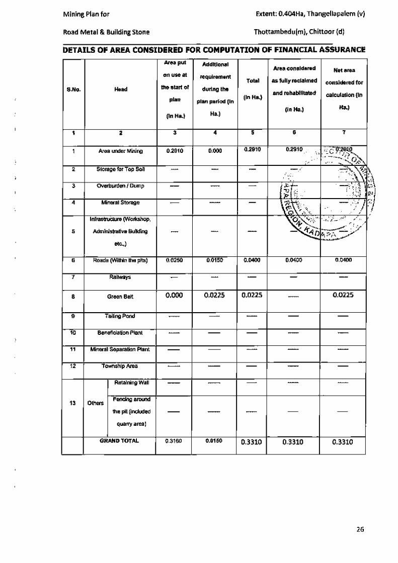
DETAILS OF AREA CONSIDERED FOR COMPUTATION OF FINANCIAL ASSURANCE
Area put Additional Area considered Net area
on use at requirement Total as fully reclaimed considered for
S.No. Head the start of during the
(In Ha.) and rehabilitated calculation (In
plan plan period (In
(In Ha.) Ha.)
(In Ha.) Ha.)
1 2 3 4 5 6 7
1 Area under Mining 0.2910 0.000 0.2910 0.2910 .·~c ~tJJt . ·.: - ~6).. " 2 Storage for Top Soil 6//. · ·~~~ ~ ,, 3 OVerburden I Dump .):> 1- ' ;i t':V' m
~ !.~ 'i.' ' l<• ·~ ! '
4 Mineral Storage - ~\'; '· / () '(ro .. v. ~. . ..:)' ,, < •
Infrastructure (Wort<shop.
~ ~c..-;;_ ... ,., , •' ..
't .,;;' 5 Administrative Building ~.· - - - D ~-
etc..)
6 Roads (WIIhin lho pits) 0.0250 0.0150 0.0400 0.0400 0.0400
7 Railways
8 Green Belt 0.000 0.0225 0.0225 - 0.0225
9 Tailing Pond - - -10 BenefiCiation Plant - - - - -
11 Mineral Separation Plant
12 Township Atea --
Retaining Wall - - - - -
13 Others FenCing around
lhe pit (inCluded -- - - - -quanyarea)
GRANO TOTAL 0.3160 0.01 50 0.3310 0.3310 0.3310
26

1
)
)
Mining Plan for
Road Metal & Building Stone
11.Certificate:
Plan for Road Metal and Building stone over an extent of 0.404Ha Hectares in
Sy. No. 211 of Thagellapalem Village, Thottambedu Mandai, Chittoor District,
Andhra Pradesh.
All statutory organizat ions, courts etc. have been taken into consideration
and wherever any specific permission is required the Lessee will approach the
concerned authorities. ., .t. · •
1 ·v' - 0
All the measures proposed in this Mining Plan wil l be ·rm:il-€mented hp'tim.e
~~~-. ',fl~' bound manner as proposed.
11.1 Plan, Section etc, ~ \/ jffl} ~ ~'(' j
Plans and Sections are submitted along with Mining Plan. '1:" ~::...~// 4/)A f>A. o '
~--
Date : 08-09-2017
Place : Kalahasthi.
SIGNATURE OF LESSEE ~~~~
SIGNATURE OF RQP G. ES\1·/AR REDDY, r.I.Sc.,B.L. Ph.D
Recogn1sed Geolog1st IBM/RQP/HYD/302/2013/A
RQP/DMG/AP/07/2014
27

Mining Plan for
Road Metal & Building Stone
ANNEXURE-I
FIELD PHOTOGRAPHS
Extent: 0.404Ha, Thangellapalem (v)
Thottambedu(m), Chittoor (d)
PHTOGRAPH SHOWING THE QUARRY LEASE AREA & SHEET ROCK FORMATION
PHOTOGRAPH SHOWING THE BOUNDARY PillAR
28

Mining Plan for Extent: 0.404Ha, Thangellapalem (v)
Road Metal & Building Stone Thottambedu(m), Chittoor (d)
ANNEXURE-I~
.. Proc .No. ~43:ol/Q/:ol007.
Sub;· Minea and Qua.rriea- Que.rT)· l.eu.,ac for Road Me1.aJ & Building Stot"\e o vt:r an e.xteot of 0 .'10'1 heel. in Survey No 211 oi1'han~e\lapalem vtll .. ftc 1'hoth.ambedu Manda!, Chittoor district for a po:riod of I 0 veano - Applicatlor\ uf Sli. V Anand Rcddy-<lrantcd-on:lcno Issued.
Rcf:· l. Q.l-. Application Dated Nil of Sri V .Anand Reddy ro::oeived L>({j~~·,-ect<>r or Minee & Oeology, C h ittooron 15-03-2007 (\'1:,..--· ~
2 . F.No. l'l32/ Q/2007, Dt: 23-0 1•2008 of Aaet. Director .,M' ce &·~ 0..(' <;h.Jttoor. £'" "''"~ .. ~""
~ .1'he Ta.h&aildar, Thothambeclu l-etter No.C / 132/2 dated: 9-0 l-~(?<l ~ ~ -~~ ~
• • • ~ ~ ...... ~ t
O.!WI!iRS: ;o 6 . e 'l'htough the refen:nce In cited Sri V. ~~cdey '""" filed
apptica.tion for grant o( quft.l"rY leaee for Roed MetaJ & Sui c§to n.e ovet· an extent .,f 1.000 h=t ;,, Su'""'-"Y No 211 of 'l'hDngellapalcni viii" 0 ::fWll:ta roboo1u Mand&J C hittoo1· Dlstdct fo1· a period of I 0 ycare .. The said applica ·~·~ • W. · l'eooivecl by the Asat. Directo•· or Min"" & Ceology, C hittoo•· on t S -03-:1007 ''~D .
..... ~ .. ' ....--::. Through the;: l"eh;:r·ence :,lod c 1led Lt'e ht: A:cl~t. r iJn:ct.UJ' ol' MTtft:.tlt"' l$6 Oeology.
Chittoor ha• reported thal t l u: appl\ed w .-:« hAa- been \napecled b,y Lh~ ~r~.chniCHI Atnugt&ul of hitt o ffice:. The: tt,pplied e..a-eu cru1 be:: appc"'achc:U fro1n Sri kaJu.hast.hi on !;d l<alahaeth i ·Taria upto the Telugu Cu.uga c:.ana.l and taking lelL clivea-aiou fr ont the•·e ftnd by moving 810118 the: c.;an.a.t loa diAt.anc..""C of at)(')Ul t krn t u,.:;t te.,kiug. icfL diversion fro1n there to Lhc avpHc:d area by metal t\.)bcJ.
"'i'he a p pUcd urea ia looated towarcla eatstena aide of the Qua.ny l...ea.ac area held by Sri. V .Anand Reddy over en t":XlC:nt of 2 .000 hectf.'>~rhe~ {,.. -.n o ld working, fac.-,c wilhin Lht: a.pplh:\J lu't« wiU.t an apJ-Jt'O)(h'Juate me&.MurtE.n-l.t.:tH or klA>llt 4 0 X <0 X 6 mtu lenRth. width o.ud depth n::~pectivel)'· Ou enquiry with local I>!Oplc h. is noted that certain l~at vad der& labours are worked long ha•:k Cor building HLone to..- tht:ir livel ihood. Al P:a"e~cut. no s~klf a.nd llO wor-kiuw:a w ·c noUc i:d .
Ueotogic:ally the applied area I~ a paJ·t or P"ninsular gneisoic: complex of At'C'hean ase group of rock$. Minera.logicuJly the rock is oon1pc:>eecl with tetajority o r l"els>c miner&Je euc h aAJ l"eldspano hnd Quartz and with enu ll q1.1nntlty or maf>O •niru:rale. l.ike alotite etc. , The roc.k avualu.bio in the ~ppbed arc.a ia leucocrat.io in colo ur. Mediu m to Coe.rae grained inoquivanular texturo.J f'MUCn'\, uneven fracture a u d wilh uumctou.-. c racks and jolnL». Prt:•~ncc or CrucktJ G6 Joint~ with in.equtgranular te..Xture and uneven fm.cture 1-nake.s the: rock au1Lable for Ro~iid Metal & Buitdin,g Stone a _nd rne.y not be auit.able for Ora uit.c Cuui.ng, & Pol•ehing Pltrpose.
Tht.: appUcd aJ'CA h as been st..trveyed and deouu-cated by the surveyu•· office or the A119t. Oin":'(..~Or o( Min~ -..nd o~~II';JRY, HnnAg&nip&JH (depul.l.\tic•nf it' preaet,-ce or tho upplico.nl Aflet· the ttnrvcy O•e oreo hua come& to 1.000 heclt~ for whic h the applieunl has (Oven luu oor, seul o n the nota.ri:tcd tillidavit . 'The.: auJVCyor ha& fu1"'ther reported Ll1~t the au""""ye<1 ~t i"'''!Q tlid nol •'!Ot1\.Ain Any publit.! itnport81nnn tH,tnh bB bui lding .. , '1\:u• ph.:~. RotuJ, RoJiw&y Hnc:K etc.
Through the reference 3 "' cited the Tahasildar, Thotharnbed.u Mandai , vide Lr. No C/ 1 ~2/2007 d"ted: 9-<>1-2008 h&& a~ntcd th.at the land in S.No 21 l i• ulu~n•illt::d &.¥ • Thak.a a. aaad U'e to~:tl c::Jhcllt o( S . No . 21 I i" 9 .Ci:i 11CI't::8 &J)d itunu:<.l No Objection Certificate h1 (avvw· ol OJ)I.JOh(;f.ltU i .c.Sr i .V.Ala.culd Rccl<.l,y.
~inaHy lhe Aaat~ OU"CC:ii, tJ l M•nc $& GeoJogy. Chi tto")J hoa reoornmendecl for grant of Quany lease application of SJ'I. V.Anaod l~eddy ror Road Metal& Building Stone oveJ' "" extent o f 0."101 hect in Survey N o:2l I o f Th•~ngellap&le•n Village ' t'ltotltamhcclu Mu.ndal C hi ttoor <.li .. tt;ul 1'01 to period of 10 years.
29

)
l
i
Mining Plan for Extent: 0.404Ha, Thangellapalem (v)
Road Metal & Building Stone Thottambedu(m), Chittoor (d)
-2-ln view o f the aboVe poeition and based on the recommendation of the Asst.
Director o( Mlnea & Geology. Chittoor a Quarry lease is hereby granted in favou1· of S ri.V •. ADaDd Redd y f or Road. uuttal e. BuD<tln r; St:one over an extent of0.404 beets in S.No 211 of Thangellapalem village Thottwnbedu Malldal, Chittoor Disllict for a period of 10 years, from the date of execution of t h e l•~ee ueocl under Rule 13(1) of APMMC Rules 1966, subject to the 10atiafuction of other termB and · oonc!Jtion of APMMC Rules, 1966, subsequent Govt. Orders and e.xcculive imstructions issuocl in the matter from time to time, Subje<.-t to the conc!Jt ions Bp<".cified in the appendix enclqaed to these orders and also 11ubject to the following conditions.
I .Thc Grantee should cxecut" the lease deed in l"orm 'G "before the Asst Director of M ines & Geology, Chitloor within 90 4$)11J from the date of issue of these orders.
2.1'he Grantee should pay the following amounts before execution of the Quarry lease deed.
("'I Dead Rent : - .R.. 2 5,000/ - per hector per annum. (bl Lslnd As11Jenment :- At t:he rate fixed by the R e venue ~tl}..~tl~ (c) S ecurity Deposit : - A • per rule• exatinft from tlme)"~~~~r-~0/t>
3.The Grantee should pa,y the .Seigniorage Fee to t h e Departjlfjlf~~~j /or ~in?>··"·.N ~ gy, in advance before desp .. tehihg the rnat.eriru from the Qua ·, e.ca!ie 'Rs O..ngc~ ~
Building Stone/Rough Stone/ Bould.ws/Road M f ~/it· BQitq_'S"t:,~~ ~ Rs.45/- I Rs. 30/ -(Rupe-.es Forty five/Thirty ~- \i.\~f,. c~;, 'fft.~ :
The Seignio r a ge 1-'ee o r l)ead Hent which ever is ~i t\11 -~·<IJ"S.££eo c;, on the M in or Minerals Diapatohed or con sumed from the d .... :.:..~1~1d <:ve..y year. ;
·y to,. <.:.. 4.1'he Gt-antee should submit n Notarized affidavit bdore U1e lis _ Director ol Mines & Oeo Jogy. Chittoor at the titne ol' execution . li1cJlcauns the b{~19:'()f A,K~ets r<"fr. the purpose of attachment "" per Section-25 ~of Mines and MJ'i'foo""'J.A....).i!cgula tion &
Development )Aot, 1957
5.-rhe Gr.·a.nt~· shou!d pay dead cent and laud-Assessntt::rJ.t in Adv:.:lttc~ in l't:H br:forc "1o< MARCH" of """'Y year for thP. Succeedin g yea.r , failing which the lease will be terminated.
6. " Tbe Onn.tee J:. lla.ble to .P"'Y the lnaome-Tax on Royalty/Seig. Fee a ll per ...me ndment oC section 206-C of Income•TilX Act.. 1961"
7. No mq>l OII.ive• alulll be u...,<l o r atorccl unW unleaa of c <>tt.lng lice nse IJ::om. the Ucenalnc authority unde r the lncli...n (ljtplosive• Act-1884
8. The w•u•te .dumpinrt from f:he rock llhould b e dumped with ln t:he 1e a11 e d area
NOTE;:- The Grant i" l-iable fm· cancellation should it be: found that it was Grossly inequitable or wa& made u11der Mistake of !"act or· owmg to Mis '"presentation
ar Frttud or iJ•J cxcet:Jts of auUh.u·it;y. J .
~!. . ..._ -L
To b'ri.V.Anand Reddy, s /o Venkata Reddy, Gandhi Slr.oe l,Sril<>dtd ro<.,Uri, C hittoor Di!\tl iGl
Dy. Direc tor or-Ml.Jie• ;:_G eolo'gy KacS...p"' Re&torl,Kadapa
Copy togeth~· w ith entir-e record of enquiry i" sent to the. Asst. Director of Minet:' & O¢ology, ChittooT with f.\ request to take rurther action.
Copy Submitt<>d lo the Directm· ol Mllres & Geology. Hyderabad fo•· favou•· of lnformatiot •
Copy eubntitted to Lhe Zonal Joint D i.-.:ctor of Miueu & Geology, Kadapa for favor of in formation
30

)
1
)
)
Mining Plan for Extent: 0.404Ha, Thangellapalem (v)
Road Metal & Building Stone Thottambedu(m), Chittoor (d)
ANNEXURE-fill
GOVERNMENT OF ANDHRA PRADESH PROCEEDli'iGS OF THE ASST. DffiECTOR OF MINES & GEOLOGY; C.'HTITOOR (Pr\..-scut: - Vt·. I<.Pw ·uacJiaudra Rav, M.S.!.,(l'cch) Ph.D., Asst. Vil·octot·)
-:oOo:-Pr·oceedlngs No.1432/Q/2007
J
RE~f:- J:'roc.~<lings No.l432/Q/2007. Dt.04-02-2008 lvfin.:s & Geulugy, Kadapa
-;oOo:-
ORnF.R:-
Datc.23 ...(11-i 001$
In vie.w of the. Above, P<'flllli:'SlOU is hE'reby ~C<'<)roed to Sri. v. ,\JHmd lieddy tu work lhr R uud 11-t.,tal & Building Stunt! """r an ~>dent or 0.404 Hc::darc in S.No.211 of11Wlgellapalem (Vg), Thonrunbe<:ltr (M), Chirtoor Dimiot for 11 p.:ri.,..-1 of HI (Ten) year.< with c!Tcct rrom 23-02-ZOOR tu 22-02-201 R, suhjo:cttu th" satisi'acticm u l' :..II Nber terms and conditions laid down in Al'.M.M.C.Rul~. 19M and subs~qu~nt Gnvc:;nlmc:nl onlt::r and C:)';(;(;Ulive inslrucliuns issue d rn)m limo iu time;,,
The Le..!'See ~hould C~l:>serve all1he <'<)Verumts of lease deed in fom< ·c_;• and tem1s and ('.Ouditions given in the appendix en<1IC1sed to this deoe.d.
The L.e-sse('o should mnintain ~II thco re<-.or<ls and il<'-<'Olmls and S\lbmi\ monthly I quRr1erly I amwal rel\lms to the Director C~f Mines and O~.ology, llyd<orl'b!ll:i. ncpuiy niredur ul Mine>.~ & Geology, Ka<.Uspa and As.'l. niredur uf Min.:s & (it:uiogy, Cl:J.ittoQr ~s pre.sC'.ribed iu Al'.M.M.C.Rul~-5, 19M, so 11s \Q reMh the re.!Sp~(:live :tuthorities nol iater than 7th day or~ucceeding month lo wh ich they rei all<.,.
To, S•·i. V.An>mcJ Reddy, Si Q. V;:.nk<HII R<e·:ldy, Ciandhi Streei., Srikalaha.~ti. C.!hinC~<:>r District
~~ Al<~t. n in>MOI' nfMinPl< &I (~nl<>gy.
Clr.Hi.uu•··
Coned. , (Z)
31
)
)
'
)
Mining Plan for Extent: 0.404Ha, Thangellapalem (v)
Road Metal & Building Stone Thottambedu(m), Chittoor (d)
ANNEXURE-TV
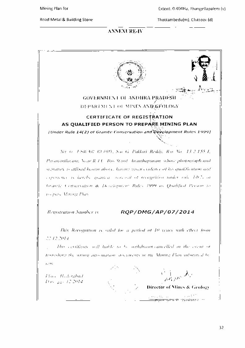
CERTIFICATE OF REGISTD·A"1'lr,
AS QUAUFIED PERSON TO PREP
{Under Rule 14(2) of Granite Conservation and
...... Sri 6. I:.'SWAH IU::o()) : S!u G Pakkiri Reddy. 1?/o No: 13-2-155-1.
Pm·al/allilayam. Near R T.C. 811,, Sttmd. Antmtlwpurtlm. whose photograph and
sig11ature is af!'u:ed herein abOI'f'. ltm•mg given e••idence of his qualijicalion and
experience is hereby grmued rene\l'al of recognition under mle 14(.2) of
Granite Conservation & Development Rules 1999 as Qualified Person to
pn!pllrt! Mining Plan.
Registration Number is : [ RQP/ DMG/ AP/07/201_4 _ _,
This Recognition is valid /rw a period ol I 0 years with effect .from
22.12.2014
This certificme will liablr to be U'ithdrawn/cancelll:t! in t/11: t!l'ellt of
(iwnLrhing the "rong information lducumellls il1 the Mining Plan submiued b;
111111
Place: Hyderabad D01e:).'J,.. .12. 2014
Direct r of , ~logy Director of Mines and Gcolon~
32

)
'
'
)
)
)
)
I
)
Mining Plan for Extent: 0.404Ha, Thangellapalem {v)
Road Metal & Building Stone
ANNEXURE-IV-A
'lfMr 'ER~fiC ~OF IM)IA llll'f b;w;:z; T 1 I ! I fl'/ <lf" IIIWE.8 ~ 1!1R' ..P1M1111111JlJR15M.JCIF- -
Thottambedu{m), Chittoor {d)
an!t'fNtl{t ~ <5 ~ 1¥ •n"'4dl 'lllfJVT {<!IlliG R>mm r.,.,qlil+i'l. ,..., tk r.r.r .. ~ ~
~ tiuf\<1'1 ~ ~ His~nmnbe~is
33

I
')
)
)
)
)
)
)
)
)
J
~ I
O.Okm 1.0 km
•
•
' TongcllgpiiliJm
- ~ *' -. . i)" , • r:.ff6 U,AMBEDU
6 ' ....,..,.\o
' s-, • ...,
'), 'P r ~ .. •
Sft111nMflllputa'(J,' A -~~ '( ~~ ... .., .. ( oa-n.-cnoC~
~
I I~ 2.0 km 3.0 km 4.0 km
79'33' 23.rE
S,NO Name Of The V111if19e
Th•ngoiJIJIPGlem
2 --3 S!bllllla•-tl
• Thang.ell~;~llem
$ .............. • .. _
13' 21)' 08.3'1'1
POCJU'lakln Oirlldlona
•50 0.7 NoM
800 1.5 NW
85000 ''" WMt
1000 1.7 se 2500 2.5 sw ... "" Nom
PLATE NO- I
/ INDEX
Thengellapolem SRI V .ANANDA REDDY QUARRY
Signature of Lessee
~ ~~ G.siWi!~'RtBbf,;?.sf.s.L Ph.o
Recoon1sed Geolog1st IBMIRQP/HYD/302/201 3/A
RQP/DMGIAP/07/2014
THIS 1$ TO CERTIFY THA 'r THE ~NFORMATION IN THIS PI.ATE
IS TRUE AND CORRECT TO THE SEST OF KNOWlEDGE BASEO
UP ON LEASE MAP Allt>iEtmCATED BY STATE GOVERNM&It,
Location-Key Plan. Plate No:-1 MINING PLAN FOR ROAD METAL & BUILDING STONE
S.No 211 , Extent 0.404 Hectare, Village Thenaellapalem, Mandai ThoHambedu, District Chitloor (Dist), AndhraPradesh State . Scale 1:50000
Toposheot No 57 0110 E79' 44' 44,4', N13' 44' 47 h'N
Lessee SRI V.ANANDA REDDY

. • .
)
-~· ...
DIST~ICT': C.HITTOOR
f"\ A tJ '0 I\ L. ·. ii-\OTTA IY\ t3 E 'DU V/ L.L~ h~ :THAN~ELL.APAL.E~
G.u"'"'>' lec..~e o.ppl.·td ~"~ t;,..; , V . ANI\ MJ) ~E l>DY •
EX·. 0 · 4 0'-t \Hdli cH
'
..... , -
t!! I
I
PLATE 1\-. ~
N -
I
)
)
)
TOPOGRAPHICAL CUM GEOLOGICAL PLAN
Geo Coordinates of lease area Datum WGS-84
POINTS LATITUDE LONGITUDE
A N13• 44' 47.0" E79• 44' 44.4"
B N13° 44' 46.9" E79• 44' 46.9"
c N13• 44' 43.2" E79° 44' 43.9"
PLATE- Ill
MINING PLAN FOR ROAD METAL & BUILDING STONE
SRI V.ANANDA REDDY IN S.F.No .. 211 , Ext.0.404,Thengellapalem(V),
Thottambedu(M),Chittoor (District), Andhra Pradesh.
TOPOGRAPHICAL CUM GEOLOGICAL PLAN
Lessee:- SRI V.ANANDA REDDY, S/o Venkata Reddy, Gandhi Street, Srikalahasti Town & Mandai, Chittoor District.
Contour Interval : 1 SCALE:- 1:1000
v ' f\ry-.._._f4~ Signature of Lessee
Signature of R.Q.P G. ESWAR RE')OY, M.Sc .• B.I.. Ph.D
R"cogntsed Geolcg,:;t IBMIROPIHYD/302/'20131 b,
RQF'iD!viG!AP/07i:.OH
THIS IS TO CERnFY THAT THE INFORMAnON IN THIS PLATE
IS TRUE AND CORRECT TO THE BEST OF KNOWLEDGE BASED
UP ON LEASE MAP AUTHENTICATED BY STATE GOVERNMENT.
I
)
)
)
)
)
)
)
J
GEOLOGICAL CROSS SECTIONS
B' ,-60
PIT -1 1 • • • • • • PIT -2 50 • 0 • •
0 • • • • • • 0 • • · ~· 50 . . . . . . . ~ .. . . .. . . .. " . . . . . . .. .. . .
• • • • • • ~ • • • • • * • • • • •
40 a a a a a • •• • a • 0
a I a • • a 0
a •• 1 a 0
·~~0 • > •• • • • i
30 · · · · · · · · · · . · · . · · . · • · ·u 30
A 60
A' 60
50 li PIT -1 .. ~ 50
40 ~~... •. ·:. ·:. ·:. ~ 40 ~ . . . . - ~ I~ •. •.. • • •• •. §
3 RS • • • • • • • •• •• • 30
PLATE -IV
• • • ' a ROAD METAL & BUilDING STONE . . . BUFFER ZONE
PROVED ZONE
lo I PIT BOUNDARY
MINING PLAN FOR ROAD METAL & BUILDING STONE
SRI V.ANANDA REDDY IN S.F.No.211, Ext.0.404,Thengellapalem(V),
Thottambedu(M),Chlttoor (District), Andhra Pradesh .
GEOLOGICAL CROSS SECTIONS
Lessee:- SRI V.ANANDA REDDY, Sfo Venkata Reddy, Gandhi Street, Srikalahasli Town & Mandai, Chittoor District.
Signature of Lessee
SCALE:- 1:1000
::h ~~ Signature of R.Q.P
G. ESWAR REDDY, I.I.Sc .. B.L Ph.D Recogntsed Geologtst
I BM/RQP/HYD/302/201 3/A RQP/DMG/AP/0712014
THIS IS TO CERnFY THAT THE INFORMATION IN THIS PLATE
IS TRUE AND CORRECT TO THE BEST OF KNOWLEDGE BASED
UP ON LEASE MAP AUTHENTICATED BY STATE GOVERNMENT.

I
)
)
)
)
"I
)
YEAR WISE WORKING PLAN & SECTIONS
FOR ONE YEAR
N125
N100
N50
N
COMMON BOUNDARY
A f'-TIT--...:3~7~6~-=-=--~~~ 45.0 45.2
PIT -1
45.0
X 60
PIT -2
45.3
E50 X'
60
B
E100
Geo Coordinates of lease area Datum WGS-84 50~~~PIT1·1~~~~··.~··~·.~··i'i 50 ' · • • ........ ·:alA
40 .~ ·. · .. : . . ·:. ·: . . ·~rO ~ . • • 4 • • ' .. .. • • ..§
3(} ~ .. ' .. . . . . .. . . . .. . . . 30
POINTS LATITUDE LONGITUDE
A N13• 44' 47.0" E79• 44' 44.4"
B N13• 44' 46.9'' E79• 44' 46.9"
c N13" 44' 43.2" E79• 44' 43.9"
PLATE- V
INDEX
WORKINGS YEAR WISE P<ANTATION
I-YEAR
MINING PLAN FOR ROAD METAL & BUILDING STONE
SRI V.ANANDA REDDY IN S.F.No.211, Ext.0.404,Thengellapalem(V),
Thottambedu(M ,Chittoor (District). Andhra Pradesh.
YEAR WISE WORKING PLAN & SECTIONS FOR ONE YEAR
Lessee:· SRI V.ANANDA REDDY, Sfo Venkata Reddy, Gandhi Street, Srikalahasli Town & Mandai, Chittoor District.
Contour Interval : 1 SCALE:· 1:1000
Signature of lessee
Signature of R.Q.P G. ESWAR REDDY, 1.1 se .. s.L. Ph.D
Recogn1sed Geolog1st ISM/RQP/HYD/302/2013/A
RQP/DMG/AP/07/2014
THIS IS TO CERTIFY THAT THE IN FORMA TlON IN THIS PLATE
IS TRUE AND CORRECT TO THE BEST OF KNOWLEDGE BASED
UP ON LEASE MAP AUTHENT1CAT1ED BY STATE GOVERNMENT.
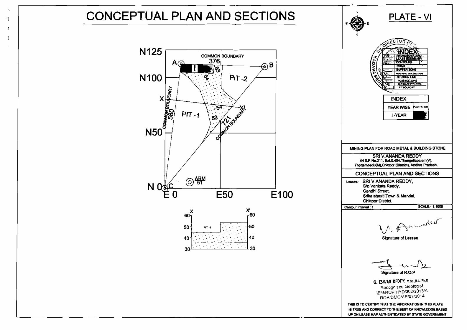
, j ,
CONCEPTUAL PLAN AND SECTIONS
N125 COMMON BOUNDARY
A r....-----...:3~7~6ly-----·k> I ~
N 1 0 0 1------t
N50
N
: ~ PIT -2 . . ~ . . ·~.
·: -~· . . . . 0 ,~--;
PIT -1
E50
X 60
X' 60
50 PIT · I l· ... •: 50 1--:----:-~....--.J· • • 0. • . • . . .
40 •••• · .. •. . ~0 ~~~~·~·~·.~·~~·~·~~ . . . . . . .
3oOL~-·~·~·-·~·-·~·~·~~3o
8
E100
PLATE- VI
INDEX
YEAR WISE ~""""'I
I-YEAR
MINING PLAN FOR ROAD METAL & BUILDING STONE
SRI V.ANANDA REDDY IN S.F .No.211. Ext.0.404,Thengellapalem(V),
Thottambedu(M),Chittoor (Oistric1), Andhra Pradesh.
CONCEPTUAL PLAN AND SECTIONS
Lessee:- SRI V.ANANDA REDDY, S/o Venkata Reddy, Gandhi Street, Srikalahasti Town & Mandai, Chittoor District.
Conlour Interval : 1 SCALE:- 1:1000
Signature of Lessee
Signature of R.Q.P
G. ESWA!! RFDCY. M.Sc.,B.L Ph.D Recogmsed Geolog1st
IBM/ROP/HYD/302/2013/A RQPtDMG/AP/07/2014
THIS IS TO CERTIFY THAT THE INFORMATION IN THIS PLATE
IS TRUE AND CORRECT TO THE BEST OF KNOWLEDGE BASED
UP ON LEASE MAP AUTHENTICATED BY STATE GOVERNMENT.
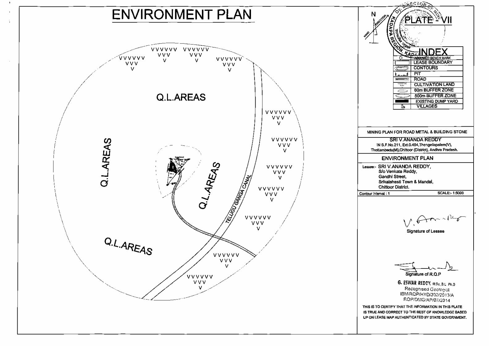
, ""'·
. --J . a
ENVIRONMENT PLAN
vvvvv vvv
v
vvvvvv vvv
v
vvvvvv vvv
v
Q.L.AREAS
vvvvvv vvv
v
vvvvv vvv
v
vvvvvv vvv
v
vvvvvv vvv
v
vvvvvv vvv
v
vvvvvv vvv
v
vvvvvv vvv
v
vvvvvv vvv
v
~ . . i
YWY'VV'f'
''' " = CULTIVATION LAND 60m BUFFER ZONE 500m BUFFER ZONE EXISTING DUMP YARD VILLAGES
MINING PLAN FOR ROAD METAL & BUILDING STONE
SR .ANANDA REDDY IN S.F .No.211, Ext.0.404,Thengellapalem(V),
Thottambedu(M),Chitloor (District), Andhra Pradesh.
ENVIRONMENT PLAN
Lessee:- SRI V.ANANDA REDDY, Sfo Venkata Reddy, Gandhi Street, Srikalahasti Town & Mandai, Chittoor District.
Contour Interval : 1 SCALE:- 1:5000
Signature of Lessee
~ ~____f'2_. Signature of R.Q.P
G. fSWAR REDDY, M.Sc.,B.L Ph.D
Recogn1sed Geolog1st IBMIRQP/HYOI302120l3/A
RQPIDMG/AP/07/2014
THIS IS TO CERTIFY THAT THE INFORMATION IN THIS PLATE
IS TRUE AND CORRECT TO THE BEST OF KNOWLEDGE BASED
UP ON LEASE MAP AUTHENTICATED BY STATE GOVERNMENT.