Embed Size (px)
Citation preview

GLUPB Response to the Government of Canada Review of the October 2011 Draft Revised Gwich’in Land Use Plan.
(GLUPB response inserted into AANDC document in blue text)
Table of Contents for Government of Canada Review Aboriginal Affairs and Northern Development Canada – AANDC ................................... 2
Federal Government Departments ................................................................................ 29
Public Works & Government Services Canada – PWGSC ........................................ 29
Natural Resources Canada – NRCan ........................................................................ 30
Parks Canada – PC ................................................................................................... 31
National Defence – DND ............................................................................................ 33
Environment Canada – EC ........................................................................................ 36
Transport Canada - TC .............................................................................................. 43
Department of Fisheries and Oceans - DFO .............................................................. 43

- 2 -
Aboriginal Affairs and Northern Development Canada – AANDC The Gwich’in Land Use Plan is the only approved land use plan in the Mackenzie Valley and was approved in 2003. In January, 2012 the Gwich’in Land Use Planning Board (Planning Board) distributed a revised land use plan for comment, pursuant to legislated periodic review. As the federal Minister responsible for approval of land use plans in NWT (s.43 Mackenzie Valley Resource Management Act), Aboriginal Affairs and Northern Development Canada (AANDC) is coordinating a collaborative federal review of the Revised Plan. Once the Planning Board has considered reviewers’ comments, the Revised Plan will be finalized and submitted for sequential approval by the Gwich’in Tribal Council, the Government of the Northwest Territories (GNWT), and the Minister of AANDC.
This document provides a summary of AANDC comments on the Revised Land Use Plan.
_____________________________________________________________________
I. BROAD REQUIREMENTS FOR APPROVAL
Building from results of AANDC’s Interdepartmental Workshop to Support Northern Land Use Planning Review and Approvals (September 28-29, 2011), the following broad criteria were identified to guide the federal review and approval process for northern land use plans. The criteria listed below are not an exhaustive list, but are provided for the Planning Board as general information on the key factors that AANDC evaluated for the Draft Revised Gwich’in Land Use Plan.
1. Legal and Policy consistency and accuracy – A Plan must accurately reflect land claims agreements and legislation, and be consistent with applicable Government of Canada policy.
• Provisions in the Plan must be consistent with legal requirements in the applicable land claims agreement.
• Provisions in the Plan must be consistent with relevant legislation. • Provisions in the Plan must be consistent with, and supportive of related policy
(e.g. Mineral and Metals Policy).
2. Effective, Efficient, and Credible Planning Process – Achieving quality final land use plans requires that planning processes are based on effective, efficient, and credible planning practices.
• Is this process transparent, credible, and based on accepted professional practice?
• Does the Plan adequately reflect federal input? • In addition to federal interests, does the Plan consider and respect interests and
perspectives of non-federal parties - including territorial governments, Aboriginal

- 3 -
governments and organizations, communities within planning region, northern residents, and key stakeholders?
3. Clarity - A plan must be clearly written so that it is well understood by its stakeholders.
• Are provisions in the Plan (namely land use zones and conformity requirements or conditions) sufficiently clear so that they can be implemented? Is there significant risk of misinterpretation?
• As written, would the implementation of these provisions meet the objectives identified for a given zone?
• Is the terminology in the Plan (including acronyms) clear and internally consistent?
4. Governance & Implementation – A Plan must reflect the authority, roles, and responsibilities of its implementing bodies.
• Are provisions requiring regulatory conformity directed to the appropriate body? Does the body that is expected or directed to implement the provision have the legal authority and the mandate to take that action?
• Are there issues of capacity and resources that need to be considered? (I.e. Will plan approval and implementation create new capacity requirements from Government? Are these capacity requirements well understood?)
• If a provision (e.g., a conformity requirement) is directed at a body other than government, does the Plan make clear what role (if any) government is expected to have in implementing or overseeing the implementation of that provision?
• Do any provisions in the Plan give rise to specific potential issues relating to the Government of Canada’s constitutional duty to consult under s. 35 of the Constitution Act?
5. Regulatory Improvement & Efficiency - A plan should contribute positively to the environmental regulatory regime.
• Does the Plan establish regional objectives to guide and streamline project proposals, environmental assessments, regulatory approvals, and environmental monitoring?
• Does the Plan contribute to regulatory improvement? Does it provide additional certainty to proponents, regulators, and key stakeholders?
• Do provisions contribute to excessive regulatory burden or procedural complexity that cannot be justified?

- 4 -
II. SPECIFIC COMMENTS
This section lists specific issues and the associated advice identified by AANDC for the Planning Board to incorporate into the Final Revised Gwich’in Land Use Plan. The Planning Board is encouraged to contact AANDC land use planning staff for further detail where required.
1.0 – Introduction ANALYSIS
• Broadly speaking, AANDC reviewers appreciated the format and layout of the Revised Plan. It is well-structured and clearly written.
• Section 1.0 presents an important overview of land use planning in the Mackenzie Valley. It describes the legal context for land use planning, the social, cultural, and economic considerations, and the importance land use planning in the regulatory regime.
• As a land management and regulatory tool, AANDC reviewers supported the Revised Plan's approach to managing natural resources in a way that maintains economic, social, cultural, and ecosystem values.
2.0 – Information about the Gwich’in Settlement Area and its Resources
2.3.2 Wildlife and Fish
ANALYSIS • Figure 11 attempts to demonstrate federally territorially listed Species at Risk in
the Gwich’in Settlement Area. In terms of federally listed species, the table provides the COSEWIC assessment and the federal designation of each listed species. The table should provide consistent information in regards to territorially listed species. As it stands, the “NWT General Status Rank” (equivalent to federal COSEWIC assessment) is listed under the “NWT SARA” heading (column 4) whereas information on the actual NWT List of Species at Risk (equivalent to SARA federal listing or Schedule 1) is not included.
AANDC PREFERRED APPROACH
1) To avoid confusion, the Planning Board should consider adding a column to the table to reflect the approach taken for federal listings (see example below). Where a species has not been assessed, the Planning Board should consider listing “Not assessed at time of publication” or “To be assessed in October 2015”, and refer the reader to the appropriate resource to determine listing as time progresses.

- 5 -
Species of Concern
Federal Species at Risk Act NWT Species at Risk Act COSEWIC assessment
Federal listing (Schedule 1)
General Status Rank
NWT List of SAR
Woodland Caribou, Boreal Population
Threatened Threatened Sensitive Under assessment at time of publication
Eskimo Curlew
Endangered Endangered At risk No assessment planned
GLUPB Response: Updated and corrected Species at Risk table on page 19, clarified NWT General Ranking program information in text on page 18.
2.4.1 Oil and Gas This section describes the status of oil and gas potential and related commercial activities in the Gwich’in Settlement Area. ANALYSIS
• The summary of oil and gas potential and Figure 12 could be amended to acknowledge industry’s ability to access and produce oil and gas from unconventional reservoirs, including shale. In doing so, it could also address development potential for resources of this type in the Gwich’in Settlement Area. A geological summary of unconventional oil and gas potential is available through the NWT Geoscience Office (Hayes, B.J.R., 2011. Regional Characterization of Shale Gas and Shale Oil Potential, Northwest Territories; Northwest Territories Geoscience Office, NWT Open File 2011-08, 34 p).
AANDC PREFERRED APPROACH
1) AANDC recommends that the Planning Board update the plan to include information on unconventional oil and gas potential.
GLUPB Response: Doesn’t seem to have associated GIS data so updating map of potential not possible at this time. Have added wording on the unconventional oil and gas potential to plan text, open file 2011-08 added to list of references.

- 6 -
2.4.3 Sand, Gravel and Crushed Rock This section describes the status of Sand, Gravel and Crushed Rock in the Gwich’in Settlement Area. ANALYSIS
• The text refers to past and current use and not to the significance of the resource, other known resources available, or the demands that might arise as current supplies become depleted and new development activities occur.
• Figure 14 appears to state that sand and gravel is only associated with glacial features. In the western portion of the planning region, the Revised Plan should also consider alluvial fans, bedrock and associated colluvium features such as talus as potential sources.
• Many other potential granular resource sites that were identified in the 1970s for regional and pipeline–related granular inventories are not shown on Figure 14. Only developed granular sites and those proposed by the Mackenzie Gas Project are shown.
AANDC PREFERRED APPROACH
1) The Planning Board should provide a more representative description of granular resources in the Gwich'in Settlement Area. Granular reference information for the Gwich'in Settlement Area can be found in the following reports:
Ripley, Klohn & Leonoff International Ltd., 1972. Granular materials inventory, zone IV,
zone V, zone VI [Calgary, Alta.]: ca. 200 leaves: ill., maps (some folded); 29 cm. (Full citation and download link at http://preview.tinyurl.com/789apvg )
EBA Engineering Consultants Ltd., 1974. Granular materials inventory, stage III [S.l.]: 4
v. (various pages): ill. (some col.), maps (some folded); 29 cm. (Full citation and download link at http://preview.tinyurl.com/2v86mx), and
Hardy Associates (1978) Ltd., 1986. Report on evaluation of granular resource potential,
lower Mackenzie Valley [Calgary, Alta.]: iv, 49, [33] leaves: ill., 4 folded maps; 28 cm. (Full citation and download link at (http://preview.tinyurl.com/7psvoxn)
GLUPB Response: Have consulted another report, including GIS, that is more recent (GSC Open file 6058) The map gets overwhelmed when adding all sites. Intent of these maps in the Plan is to provide general information and a sense of potential for each land use. They are not at a scale to provide full representation of this resource. Added text in the legend of figure 14 to clarify it showed “some” features associated with granular resources, and the above documents were added as references so readers can access them independently.

- 7 -
3.0 – Land Ownership, Management and Regulation
3.2 Mackenzie Valley Resource Management Act ANALYSIS
• The first sentence of the fifth paragraph of section 3.2, (beginning with “A list of regulatory …” should be moved to end of the first paragraph of 3.1. Additionally it would be helpful to include the current Appendix C as a table within this section since it shows the types of activities that may occur within the planning region and the associated regulatory controls.
AANDC PREFERRED APPROACH
1) AANDC recommends that the Planning Board adjust the text as described above.
GLUPB Response: Preference is to leave 3.1 as a description of land managers/owners only. Updated to reflect devolution. Have renamed 3.2 to “Regulation” with the MVRMA highlighted and a bit more discussion of the other regulators/legislation. Table from Appendix C was brought to this section.
3.6 Mackenzie Valley Environmental Impact Review Board ANALYSIS
• The flowchart and text suggest that it is only the Minister of AANDC who makes a decision on a Review Board or Joint Review Panel Recommendation. This is incorrect - other responsible Ministers are also part of the decision-making process.
AANDC PREFERRED APPROACH
1) Figure 17 - In the section that lists Minister of AANDC, please add: "...and Responsible Ministers."
2) “Stage Two: Environmental Assessment” should include a reference to other
responsible Minsters’ role in the decision making process. Recommended wording:
“The Review Board submits its recommendation to the Minister of Aboriginal Affairs and Northern Development, who distributes it to the other responsible Ministers having jurisdiction in relation to the proposed development. The Review Board may reach one of the following determinations: [include bulleted list]

- 8 -
3) “Stage Three: Environmental Impact Review” - This section requires clarification
in order to accurately reflect the process. It should read: “...An independent panel of members appointed by the Mackenzie Valley Environmental Impact Review Board conducts the environmental review and submits its recommendation to the federal Minister, who distributes it to other responsible Ministers having jurisdiction in relation to the proposed development. For environmental impact reviews of oil and gas projects that fall within the National Energy Board's jurisdiction, the panel would also submit its recommendation to the National Energy Board.”
GLUPB Response: Changes made.
4.0 – Vision & Land Zoning
4.4 Regional Conditions
ANALYSIS • AANDC acknowledges the Planning Board’s rationale for including Regional
Conditions as a means to address land management issues throughout the Gwich’in Settlement Region. The department also observes that these were not part of the approved 2003 land use plan and that they will have new implications for proponents and Regulatory Authorities. AANDC suggests that the Planning Board expand upon the context and rationale for these conditions, and consider setting out a clear set of expectations for achieving them.
• AANDC’s interpretation is that regional conditions would not apply to land dispositions (ex. Access Agreements, surface leases, or mineral claims).
AANDC PREFERRED APPROACH For all regional conditions:
1) AANDC will not approve a Revised Plan that does not include clear tests for conformity for the regional conditions. This may be achieved by adding a subsection to each regional condition titled ‘Test for Conformity’, with a list of information items that proponents will be required to provide to meet conformity.
2) To provide even more clarity, AANDC recommends that the Planning Board include a table for this section that clearly summarizes which regional conditions would apply to specific authorizations (as listed in Appendix C).

- 9 -
3) Some Regional Conditions should be revised to become ‘guiding principles’ or ‘priority concerns’ to emphasize the specific land use issues of concern to proponents and regulators.
GLUPB Response: The Planning Board drafted the regional conditions with the consideration that “...those authorities with jurisdiction to grant licences, permits, leases or interests relating to the use of land and water in the settlement area shall conduct their activities in accordance with the plan.” (GCLCA 24.2.10) The Planning Board does not feel there is much value including a table that summarizes which conditions apply to which authorizations. Proponents and regulators will be able to determine that fairly easily as they consult the Plan (e.g. applications regarding a Tourism Operators Licence are not going to be relevant to the Uranium or Hydraulic Fracturing conditions). The Planning Board does not support creating another section titled along the lines of ‘Priority Concerns’ (already have guiding principles) as we feel the issues represented in the current regional conditions will not receive the same emphasis on their importance or due consideration. However, it is agreed that the wording of the regional conditions can be improved. With clearly worded conditions and sufficient background on the intent of each, a determination of conformity will be fairly straight forward. The requirement of a subsection titled “Test for Conformity” would then be unnecessary. Our reasoning on this is that a properly worded condition will indicate the information that must be provided, or actions that must be taken. The Planning Board can always be approached by regulators and proponents if there are still questions.
4.4.1 Water Quality and Quantity
This condition would require proponents to demonstrate that water quality, quantity and rate of flow will remain ‘substantially unaltered’ throughout the Gwich’in Settlement Area. This condition is in response to community concerns about quality and quantity of water. The purpose of the condition is to have regulatory authorities set site specific terms and conditions for authorisations using a ‘strict precautionary approach’. ANALYSIS
• This condition reflects a right that is described in the Gwich’in Comprehensive Land Claim Agreement (GCLCA) at s.19.1.8 and applies to 'Gwich'in Lands'. Gwich’in Lands are defined by the GCLCA as "Gwich'in municipal lands and settlement lands". This regional condition would extend the provision to the entire Gwich'in Settlement Area.

- 10 -
• This right is also subject to legislation in respect of the use of water including the Northwest Territories Waters Act and the MVRMA. Pursuant to this legislation, the Land and Water Boards are responsible for regulating water use and the deposit of waste. The Land and Water Boards have the discretion to add terms and conditions to manage and protect water quality and quantity. The Land and Water Board’s authority for regulating water use and deposits of waste extends throughout the Gwich'in settlement Area, including over Crown, Gwich'in and private lands. During the review process for an application, the Land and Water Board is responsible for consulting with affected communities, the GTC, and other government agencies. The Planning Board did not provide any documentation that the Mackenzie Valley or Gwich’in Land and Water Board were consulted in the drafting of this regional condition. Given the active and legislative role of the Land and Water Boards in implementing such a condition, their feedback is essential.
• It is not clear how Regulatory Authorities would implement this regional condition. As discussed in AANDC’s 2010 Submission to the Planning Board, the definition of ‘substantially unaltered’ remains unclear and subjective, so it does not fit well in a regional condition that requires a clear test for conformity. The first evaluation factor ‘...by the level of concern expressed by Gwich’in participants who will have expectations as to what clause 19.1.8 means’ attempts to provide a description of how ‘substantially unaltered’ might be interpreted, but actually adds further subjectivity rather than clarity. The Planning Board should consult directly with the Land and Water Boards and Mackenzie Valley Environmental Impact Review Board to get technical expertise on interpreting and implementing future versions of this condition.
• AANDC recognizes that water is a critical component of cultural, spiritual, economic and social well-being for residents of the NWT, particularly Aboriginal peoples. The Northern Voices, Northern Waters: NWT Water Stewardship Strategy (the Strategy) and NWT Water Stewardship: A Plan for Action (2011-2015) were led by a committee of Aboriginal and government representatives, including the Gwich'in Tribal Council. AANDC is a co-lead on the implementation of the Strategy with the GNWT and is committed to its Vision: “The waters of NWT will remain clean, abundant, and productive for all time.” Through this initiative and obligations under land claims and associated legislation, AANDC believes that waters in the Gwich’in and NWT can be effectively co-managed, and that all water stewardship decisions respect Aboriginal rights
AANDC PREFERRED APPROACH 1) AANDC does not support inclusion of 4.4.1 as a regional condition in the Plan.
However, it is important that the concerns and context for this condition not be lost by removing 4.4.1 as a condition. In order to highlight the importance for proponents to address this provision from the GCLCA, AANDC maintains (as per comments on the April 2010 Draft Plan) that it should be listed as a ‘Priority Concern’ for proponents to consider when preparing applications. Clearly,

- 11 -
proponents need to address this concern as early as possible in their applications so as to avoid referral to Environmental Assessment. Since the intent of the condition is to “...have regulatory authorities set site specific terms and conditions...using a strict precautionary approach”, AANDC also encourages the Planning Board to work closely with the Land and Water Boards to determine how Land and Water Board policy and processes might address the intent and concerns raised during community consultation on the Revised Land Use Plan.
GLUPB Response: The condition was rewritten to resemble AANDC’s recommended wording for SARA. It is a reiteration of the GCLCA sections 19.1.8 to 19.1.17 and the MVRMA sections 75 to 79. It does not create any new responsibilities and the subjective language pre-exists the Plan. The Land and Water Boards should already have established policy on interpreting and implementing. Text in the Plan describes the intent and value of this condition.
4.4.2 Reclamation Using Native Species of Plants
This regional condition refers to reclamation plans and the specific level of detail required for a project application to conform. ANALYSIS
• Recognizing that reclamation is both long-term, and progressive, it is not clear how the Planning Board will implement this condition and determine conformity up front prior to reclamation plan(s) being finalized.
• Given that the intent of the regional condition is to minimize the introduction of invasive plant species into the GSA, the Planning Board may wish to consider the same approach as the Sahtu Land Use Planning Board. The Draft Sahtu Land Use Plan requires that proponents take all reasonable precautions to prevent introduction of non-native species or sub-species. This goes beyond plant species, and applies to any non-native species (fish, insect, or mammal).
• The Planning Board should be aware that AANDC Inspectors make every effort to ensure that prescribed seed mixes are native whenever possible. However, proponents are not always able to accomplish this. In these cases, AANDC suggests using seed mixes that have been proven to work in the area for terrain stability. AANDC also seeks advice from the Aurora Research Institute (ARI). ARI conducts research related to plants and reclamation and as such are subject experts.
AANDC PREFERRED APPROACH
1) Reference to reclamation plans should be removed. If the Planning Board wishes to pursue this approach, it should be addressed through recommendations on Land and Water Board policy and guidelines for reclamation plans.

- 12 -
2) In order to reflect the intent of the regional condition (reducing the risk of introducing invasive species), it is recommended that the wording be changed to reflect all non-native species, and to be consistent with the Draft Sahtu Land Use Plan: “A land use activity shall not result in the intentional introduction of non-native plant and animal species. All reasonable precautions must be taken to minimize the unintentional introduction of non-native species or sub-species.” Subsequently, the title for the regional condition should be changed to “Non-native Species Introduction” or “Reducing Risk for Introduction of Non-native Species”.
GLUPB Response: Took out reference to reclamation plans and made reference to reclamation activities instead. The Land and Water Board may include in a permit conditions respecting the restoration of lands as per Mackenzie Valley Land Use Regulations section 26. (1) (o). Also adjusted the wording to provide recognition of availability/suitability issues for native plant stock or seed mixes. Provided example of this wording in the Edits Made to the Final Revised Gwich’in Land Use Plan document. Regarding non-native animal species, the Planning Board will add the issue to the Regional Plan of Action for consideration over the next five years. At this time there hasn’t been significant concern expressed for this that wouldn’t already be addressed by legislation (e.g. aquaculture is regulated so consideration would be given to the risk and impacts of the accidental introduction of non-native fish species before issuance of an authorisation).
4.4.3 Boreal and Northern Mountain Woodland Caribou This condition requires that proposed activities avoid disturbing the habitat or calving areas of Boreal and Northern Mountain Woodland Caribou. ANALYSIS
• For Boreal Woodland Caribou, this condition overlaps with Section 4.4.5 – Species at Risk under Regional Conditions that Apply in All Zones.
• Northern Mountain Woodland Caribou are federally listed as a species of ‘special concern’. Any conditions set by the Plan should make reference to and acknowledge levels of protection offered through this designation.
AANDC PREFERRED APPROACH
1) This regional condition should be a sub-point under the ‘Species at Risk’ regional condition so that all Species at Risk-related items are captured in a logical manner.

- 13 -
2) Conditions for activities that would affect Boreal Woodland Caribou: see AANDC preferred approach for 4.4.5(1).
3) Conditions for activities that would affect Northern Mountain Woodland Caribou: see reference to 4.4.3 under AANDC Preferred Approach for 4.4.5.
4) Ensure that GNWT technical expertise is sought for status of local caribou Management Plans.
GLUPB Response: Moved to 4.4.5 (renumbered to 4.4.4. after the move) discussion under comments on 4.4.5
4.4.4 Pit Management Plans for Granular Resources This condition requires that pit management plans be submitted for all new pits. The implied intent is to promote effective use of granular resources, and ensuring that appropriate archaeological assessments are undertaken prior to authorizing such activities. ANALYSIS
• AANDC, as the Minister responsible for the Territorial Quarrying Regulations, require the submission of a Pit or Quarry Development Plan before issuing permits under the Territorial Quarrying Regulations on Crown Land. The current regulatory process also encourages the participation of affected Aboriginal groups and stakeholders (like the Prince of Wales Northern Heritage Center and the Gwich’in Social and Cultural Institute). It is not clear how this condition will change or improve current practice since the intent was not provided in the description of the condition.
• As per AANDC’s response to the Joint Review Panel for the Mackenzie Gas Project on Recommendation 13-1, AANDC agreed with the intent to develop a Granular Management Plan and will continue to work towards development and implementation of a plan for Crown lands in the Mackenzie Gas Project area.
• The template for a pit management plan is missing a section requiring the proponent or land manager to determine that the proposed site actually contains resources of suitable quantity and quality. The information required under the ‘site analysis’ section is too generalized for meaningful resource analysis.
AANDC PREFERRED APPROACH
1) AANDC supports proactive management of pits and granular resources through its current practices. AANDC views this condition as an item for the Regional Plan of Action rather than as a Regional Condition.

- 14 -
2) When describing this item in the Regional Plan of Action, AANDC encourages the Planning Board to include more context as to what is already required as part of quarry permitting in NT. The Planning Board should also refer to the Northern Land Use Guidelines for Pits and Quarries (Vol. 07, http://www.aadnc-aandc.gc.ca/eng/1100100023585), which is a valuable guide for proponents.
3) The following additions are recommended for the management plan template: Site Analysis: • Locations of existing subsurface investigations (e.g. test pits, boreholes, and geophysical surveys) Resources Analysis: • Determination of resource supplies (location, extent and quality of granular resources) • Estimation of available resources (proven, probable, prospective resources) Proposed operations: • Additional subsurface investigation (test pits, boreholes, geophysics) required to verify resources estimates)
GLUPB Response: The Planning Board added recommended wording that provides more detail to the site analysis section of the template. Added more context for condition in revised wording in the Plan.
4.4.5 Species at Risk
The intent of this condition is for proponents to identify species at risk related issues early on in the application process. ANALYSIS
• 4.4.5 (1) The federal Species at Risk Act (ss. 32, 33, and 58) imposes requirements on proponents with regard to limiting activities that may have a negative outcome for Species at Risk. AANDC appreciates that the intent of this regional condition is to identify Species at Risk issues early on in the regulatory process as opposed to during a preliminary screening or environmental assessment. The Planning Board refers to ‘significant adverse effects’ in this section. This phrase does not align with the federal Species at Risk Act and will be difficult for proponents, Regulatory Authorities, and the Planning Board to interpret. This regional condition must be revised to align with existing legislation. As currently interpreted, this regional condition would not only apply to species listed as ‘extirpated’,’ endangered’, and ‘threatened’, but also to species listed as

- 15 -
‘special concern’. This extends beyond what is required under the federal Species at Risk Act.
• 4.4.5 (2) As interpreted, every land use activity would require that a rare plant survey be conducted. Rare plant surveys should have a minimum threshold requirement. The Draft Sahtu Land Use Plan sets MVRMA authorisations as the minimum threshold for this requirement. Furthermore, there should be a map of a well-delineated area where rare plants might be expected (e.g., within glacial refugia).
• 4.4.5 (3) – It is not clear what body or organization ‘nwtsoer’ represents, or why it would collect observations of Species at Risk.
• For clarity and flow, the Planning Board should include the condition for Boreal and Northern Mountain Woodland Caribou (4.4.3) under this heading.
AANDC PREFERRED APPROACH
1) 4.4.5 (1) The Planning Board must ensure that this regional condition aligns with wording in the federal Species at Risk Act (specifically ss.32, 33, and 58). For example, 4.4.5 (1) might read: “Pursuant to and not superseding federal and territorial Species at Risk legislation, proponents requiring a permit, license or authorisation shall demonstrate that the proposed activities will not:
(i) kill, harm, or harass, capture or take an individual of a wildlife species listed as extirpated, endangered, or threatened, or
(ii) damage or destroy the residence of one or more individuals of a wildlife species that is listed as endangered or threatened in the federal SARA, or
(iii) destruct critical habitat of a listed threatened species (on federal lands).”
The Planning Board should also provide links to relevant legislation and regional contacts to consult on Species at Risk. There should be a description of what the existing legislation accomplishes and how this regional condition works in compliment with that legislation.
2) 4.4.5 (2) Rare Plant Surveys - AANDC requests that the Planning Board set MVRMA authorisations as the minimum threshold for requiring a rare plant survey. In addition, there should be a spatial filter added to the requirement so that proponents are not required to carry out unnecessary surveys. AANDC suggests the following revision: “For MVRMA authorisations, proponents must conduct a rare plant survey when the proposed land use activity occurs within known glacial refugia (see Map X).” The Planning Board should also include maps of these features in the Land Use Plan and provide associated SHP files for proponents through the Planning Board’s website.

- 16 -
3) 4.4.5 (3) would require proponents to report sightings of Species at Risk to [email protected]. In the interest of clarity, the Planning Board should provide the organization’s name as well as the email address (Ex. GNWT, ENR, and State of the Environment Report). Consider adding context that describes the importance of collecting this data for said organization.
4) 4.4.3 - Since Boreal Woodland Caribou are already protected as a threatened species through federal Species at Risk legislation, it is redundant to specify this species. 4.4.5(1) (as revised by AANDC) and the federal Species at Risk Act capture the requirement not to disturb this species or destroy its habitat. Northern Mountain Woodland Caribou are listed federally as ‘special concern’, so the ss. 32, 33, and 58 of the Species at Risk Act do not apply. To adequately address habitat protection and calving grounds for this subspecies, the Planning Board should consider alternative approaches. For example, include specific details that proponents must conform to within the range of Northern Mountain Woodland Caribou, or by addition of a special management zone that overlaps the Northern Mountain Woodland Caribou range that sets out specific conditions.
5) Conformity Tests 4.4.5 (1) The Planning Board should clarify how it will judge effects on Species at Risk. Will the Planning Board consult with relevant experts (Canadian Wildlife Service, Environment and Natural Resources, and Gwich’in Renewable Resource Board)? Or will the proponent’s demonstration of consulting with these authorities meet the test for conformity? 4.4.5(2) The Planning Board should state how this regional condition will be implemented (ex. through a condition in an authorisation). 4.4.5(3) The test for conformity is not clear for this condition, and requires explanation in the context section. For example, would a proponent simply have to imply intent to contact GNWT if Species at Risk or amphibians are observed?
GLUPB Response: Used recommended wording for condition. Added clarification on intent in Plan document which should address most concerns listed above. Added wording for proponents and regulators to consult with GNWT/GRRB for specific measures to address impacts on caribou. GRRB and GNWT could then draw from the latest caribou management plans, or make recommendations in the absence of one.

- 17 -
4.4.6 Development and Exploration of Uranium
This condition reflects concerns from the Gwich’in Tribal Council and communities of impacts associated with exploration and development for uranium resources. The Revised Plan states that this condition could be removed once concerns over adequate management and regulation were addressed. ANALYSIS
• AANDC recommends that the Planning Board provide additional rationale to describe specific concerns. If there are particular issues surrounding uranium exploration and development that the Gwich'in wish to avoid, those should be identified.
• The Northwest Territories and Nunavut Mining Regulations (Mining Regulations) [s. 11 (1)(f)] prohibit prospection for minerals or staking a claim on lands that are subject to a prohibition under an approved Land Use Plan In this regard, the Mining Regulations intend to restrict prospecting and staking generally – not specifically.
• The Mining Regulations do not make any distinction between different types of minerals for which a person might prospect and/or stake. An application for a mineral claim must not specify the type of minerals for which the claim is recorded. The Mining Recorder has no authority to refuse to record a claim based on a specific mineral. As a result, AANDC does not have a legal mechanism to implement this provision.
AANDC PREFERRED APPROACH
1) This restriction conflicts with the Mining Regulations as no distinction between minerals types is made when rights are issued. AANDC cannot approve a Revised Plan that includes this Regional Condition.
2) As an alternative to this regional condition, the Revised Plan could include a statement on the community concerns of impacts associated with uranium exploration and development within the Gwich’in Settlement Area (may be included in the proposed new section ‘Priority Concerns’).
GLUPB Response: Removed the aspect of restriction. Condition places emphasis on requirement of meetings and consultation to occur prior to regulatory process. Wording was revised to provide proponent with information so that they are prepared for level of concern to be expected from the communities.

- 18 -
4.4.7 Coal bed methane and Shale Gas* Exploration and Development This proposed condition to prohibit coal bed methane and unconventional (e.g. shale) oil and gas exploration and development reflects concerns of the Gwich’in Tribal Council and its’ communities. Once the Gwich’in Tribal Council and its communities have confidence adequate policy and legislation exists to regulate these activities and address their impacts, then this restriction could be removed. *Note: AANDC clarified with the Gwich’in Land Use Planning Board that this regional condition is meant to apply to both shale gas AND shale oil resources. AANDC suggests referring to these resources (throughout the Plan) as ‘unconventional oil and gas’. ANALYSIS
• Pursuant to s. 21.1.2 of the Gwich’in Settlement Agreement, prior to opening any lands in the GSA for oil and gas exploration, Canada must notify the Gwich’in Tribal Council and provide it with the opportunity to present its view on the matter. This process ensures that concerns expressed by the GTC are recognized by AANDC in advising the Minister.
• Given the current focus of the industry on unconventional oil and gas, this proposed condition is very likely to result in proponents completely avoiding oil and gas exploration or development in the Gwich’in Settlement Area. The Gwich’in Tribal Council have indicated their interest and support for increasing oil and gas exploration investment in the region whereas this regional condition might actually hinder that goal
• AANDC is organizing information sessions throughout the Mackenzie Valley on unconventional oil and gas resources. The Planning Board and/or Gwich’in Tribal Council should contact AANDC if they are interested in arranging presentations in Gwich’in communities. These information sessions may assist in addressing concerns related to unconventional oil and gas development in the Gwich’in.
• AANDC is responsible for issuing leases (e.g., Exploration Licences) for oil and gas exploration in the NWT. Legislation that regulates oil and gas in Canada does not make any distinction between conventional and unconventional, regular natural gas, coal bed methane or shale gas. The resources are simply referred to as ‘gas’ in legislation. Similarly, there is no distinction between ‘shale oil’ and ‘oil’. It is unlikely that distinctions could be made in the Exploration Licence on these grounds.
• Issuing a license that would exclude exploration of any ‘shale’ encountered in a drilling well is not practical. Similarly, a ban on ‘fracturing’ may not be practical as this term applies to a wide spectrum of technology – some of which do not use water at all (e.g. acid fracturing). It is worth noting that hydraulic fracturing is also used in conventional reservoirs to enhance permeability.
• The Planning Board refers to a ‘lack of regulations in NT’ and ‘water policy’. It would be helpful for the Planning Board to provide specific examples of how the

- 19 -
current legislation (NWT Waters Act, MVRMA) and policy (NT Water Strategy) are not meeting the interests of Gwich’in communities.
AANDC PREFERRED APPROACH
1) AANDC will not approve a Plan that includes this regional condition. AANDC notes that matters relating to opening lands for issuance of exploration licences will continue in accordance with the GCLCA. Given that there are clearly concerns about the associated practices for extracting unconventional oil and gas, AANDC suggests that these concerns be described as a ‘Priority Concern’ rather than as a regional condition. This will ensure that the concerns are not lost, and that proponents will be aware of this important issue prior to considering such development in the GSA.
GLUPB Response: Removed the aspect of restriction. Condition places emphasis on a requirement of meetings and consultation to occur prior to starting the regulatory process. Wording was revised to provide a proponent with information so that they are prepared for level of concern to be expected from the communities.
4.4.8 Sumps
This provision requires that proponents seek alternative methods to manage the disposal of drilling wastes and grey water. It stems from concern that sumps (particularly in permafrost) lose integrity over time. ANALYSIS
• It is not clear in the Revised Plan whether there is a minimum threshold associated with this condition. For example, would even small camps fall under this condition? Through correspondence with Planning Board staff, AANDC confirmed that indeed, this condition is an outright ban on all sumps (greywater and any other drilling waste). The draft Plan does state that a proponent could apply for an exception provided that the proposed sump is designed to mitigate environmental impacts.
• AANDC understands that the Gwich’in Tribal Council’s policy is not to support permits or licenses for Gwich’in Lands that propose sumps as a disposal method. The Inuvialuit Settlement Region also has a region-wide moratorium on sump construction for drilling waste.
• Greywater and Sewage Management: AANDC’s Northern Land Use Guidelines for Camps and Support Facilities (http://www.aadnc-aandc.gc.ca/eng/1319659277961) provide practical and environmentally sound guidelines for managing greywater and sewage based on the size of camp. For example:

- 20 -
o P. 22 For small mobile camps that remain at a site for no more than a few days may be permitted to disperse greywater over land. Particularly in permafrost terrain, there is less environmental risk from over land dispersal of grey water than from excavating sumps.
o P.23 For small stationary camps, greywater should not be discharged directly next to or into a water body. Greywater can be stored in an excavated sump located at least 31m away from a water body. Coarse gravel should be placed in the bottom of the sump to provide filtration, and support built on the sides to prevent slumping. When full, greywater sumps should be covered with sufficient material to allow for future ground settlement. See Figure 1 below.
o P.23 For large stationary camps, proponents should seek expert engineering advice and consultation with relevant licensing boards prior to selecting a site or installing greywater systems since treatment systems or lagoons may be required.
Figure 1 – Example of a properly constructed greywater sump for a small stationary camp. From: Pg 23 http://www.aadnc-aandc.gc.ca/DAM/DAM-INTER-NWT/STAGING/texte-text/nlug6_1313789162200_eng.pdf).
• Other sumps: Sumps are used for a variety of industrial purposes. Alternatives to sumps include land-spraying, downhole injection, or shipping waste offsite to a southern treatment facility. Downhole injection generally requires a critical mass of drilling exploration before it becomes an economically feasible option. Shipping of wastes to southern treatment facilities is also expensive, but one of the only other options available. Sumps or alternatives should be considered on a case-by-case basis.
AANDC PREFERRED APPROACH
1) Since there is such a wide range of cases where sumps can be used as a waste management tool (e.g., greywater treatment for small camps, or depositing drilling wastes), the condition should include more detail differentiating how various sumps might be permitted. The Planning Board should consider a separation between sumps for managing greywater versus industrial sumps. The Planning Board might consider adopting AANDC’s Guidelines for Camps and Support Facilities with regard to greywater sumps, and that use of sumps for

- 21 -
any other use would not be permitted unless the proponent can clearly demonstrate acceptable mitigation methods. Suggested rewording: “1. For greywater and sewage management, proponents should follow the AANDC Northern Land Use Guidelines for Camps and Support Facilities: 4.4.2 Sewage and Greywater. < Describe specific requirements under the ‘conformity test’ section.> 2. Sumps for storage or treatment of any substance other than greywater/sewage are not permissible. Proponents may apply for an exception to this prohibition if they can demonstrate that the proposed sump would not have negative environmental impacts.”
GLUPB Response: The condition has been reworded to clarify that the intent is a restriction on all types of sumps. If a proponent feels strongly that a sump is necessary for a project this can be considered using the exception or amendment process. Exceptions can usually be processed within the timelines of regulatory authorities so will not create delays if a proponent has the required information prepared for a regulatory authorization.
4.X Suggested new Section: ‘Priority Concerns for Gwich’in Communities’
ANALYSIS • AANDC appreciates the role of Regional Conditions in identifying land use issues
of concern in the GSA. However, several of the conditions cannot be implemented as proposed due to legislative conflicts. An alternative approach is to create a section to identify and describe specific region-wide concerns but not tie them to specific conditions. Proponents would be informed of the importance of the concern and provided additional information for use when they are preparing applications for land use activities in the Gwich’in Settlement Area. It is important for proponents to recognize the rights associated with the GCLCA, as well as other land use concerns that will be closely scrutinized in the Gwich’in Settlement Area. For example: “4.3.1 Priority Concerns for Gwich’in Communities [Proposed subheadings, context to be drafted by the Planning Board]
• Rights identified through the GCLCA (encourage proponents to refer to the Claim)
• Water Quality & Quantity (water is generally described in 2.3.1, but this section could expand upon what communities concerns and expectations are with regard to development and maintaining water quality and quantity, and discuss initiatives like the NWT Water Stewardship Strategy)
• Uranium development (list concerns as discussed in the context for the draft regional condition)

- 22 -
• Coal bed methane and unconventional oil and gas (same as Uranium) • Other overarching concerns • Suggested practices for granular resource management”
GLUPB Response: As previously stated, the Planning Board does not support creating another section titled ‘Priority Concerns’, or integrating these issues into the guiding principles section. The issues represented in the current regional conditions will not receive the same emphasis on their importance or due consideration as a “priority concern”. This is why the Board insists they remain in the core of the Plan, or working section, which is Chapter 4. Full consideration has been given to the regulatory process and comments received, and the Planning Board feels we have developed reasonable, even if somewhat unconventional, conditions.
4.6 Lands in Gwich’in Special Management Zones
4.6.10 Tsiigehshik – Mouth of the Arctic Red River SMZ ANALYSIS
• ‘Conditions regarding Tourism Value’ - This condition would require that new activities (not related to maintenance, construction and operations on the existing right of-way), not be visible from the highway. AANDC has a standard set of criteria for construction of cabins along highways that would enhance this condition.
AANDC PREFERRED APPROACH
1) The plan should refer to AANDC’s Land Administration Cabin Criteria which states: “…sites should not be located along major highways (edge of highway), they should be at least a minimum of 50 meters and up to 400 meter from known highways. A 30 meter tree screen must be maintained between the lot boundary and highway and access should be dog-legged to obscure view from the highway.”
GLUPB Response: The Board supports the Plan’s current wording as it provides for a general objective that regulators and proponents are clearly aware of. There are many areas where a dog-legged tree screen may not be an option, but regulators have the discretion to
- 23 -
apply this to an authorization as a requirement for a project to meet conformity when appropriate. More detailed planning is needed before more prescriptive measures should be incorporated into this condition. In the meantime, the exception or amendment process allows for case-by-case consideration of projects that would change the landscape within the relevant zones.
4.6.17 Tsiigehshik Gwitl’it – Headwaters of the Arctic Red River SMZ
ANALYSIS • ‘Conditions regarding Dall’s sheep’ – This would require all Regulatory
Authorities to inform affected outfitters of development activities. The onus is on the outfitter to regularly refer to public registries where permits and authorisations are listed.
AANDC PREFERRED APPROACH
1) AANDC recommends that the Planning Board remove or rephrase condition (2) [“Regulatory groups issuing permits, licenses or authorisations in licensed outfitter areas will refer applications to the affected outfitters to inform them of development activities.”]. Alternatively, the Planning Board should refer outfitters to public registries where permit issuances can be monitored. Outfitters are also encouraged to contact regulatory Boards and request to be added to relevant Referral Lists.
GLUPB Response: Have reworded the condition with text that explains the value of outfitter participation in the regulatory process, but does not require it. The second part of the condition may not be a “condition” in the strictest sense, but the Board is taking the opportunity to use the Land Use Plan as a tool to promote best practices or assist with establishing lines of communication for more integrated resource management.

- 24 -
4.7 Lands in Gwich’in Conservation Zones/ Gwich’in Heritage Conservation Zones
4.7.1 General Rules for Conservation and Heritage Conservation Zones ANALYSIS
• P. 110 – Communication corridors are listed as a prohibited use in these zones. AANDC is aware of a potential fibre optic cable project (Mackenzie Valley Fibre Optic Link). This corridor may pass through these zones. The proponent has not yet applied for a licence or easement.
AANDC PREFERRED APPROACH
1) AANDC recommends that the Planning Board consider all potential infrastructure developments so that general rules are not overly restrictive.
GLUPB Response: The Planning Board has considered potential infrastructure developments with the best available information. These are conservation zones. The rules are set as a means to meet the objective of the zone. That said, the regulatory approvals for the Mackenzie Valley Fibre Optic Link were not affected by overly restrictive rules in the Gwich’in Land Use Plan. The exception and amendment process made allowances for the fibre link project while still respecting the objectives of the conservation zone. Contact our office for detailed information on the application of the Land Use Plan to the Mackenzie Valley Fibre Optic Link project.
4.7.2 Special Consideration Respecting the General Rules ANALYSIS
• i) Rules for a Pipeline - Environmental impacts may actually be increased when preventing use of the nearest available granular resources (ex. large volumes of granular resources would have to be tracked or barged from a greater distance which increases the carbon footprint of a project and increases the risk of spills).
• ii) Rules for Extension of Highways – Construction of new highways requires access to large quantities of suitable granular resources. The Planning Board should consider whether a ‘winding route between potential borrow sites’ is preferable to allowing for occasional development of required sites outside of the two kilometer transportation easement.
GLUPB Response:
i) Rules for a Pipeline: This was actually considered and discussed with the proponent of the Mackenzie Gas Project. The appropriate exceptions and

- 25 -
an amendment were identified that would have addressed this specific conformity issue based on the draft regulatory applications. If you wish to learn specific details, please contact our office.
ii) Rules for Extension of Highways: The Planning Board is a little unsure of the reasoning behind this comment. The Plan does not contain any reference to a 2 kilometer transportation easement to be established along potential highways in Conservation Zones. It also does not provide any guidance or policy that would direct proponents to select a type of route, ‘winding route between potential borrow sites’ or otherwise.
Once a route has been determined and has met the terms of the Gwich’in Comprehensive Land Claim Agreement, the Board shall review the Land Use Plan to assess the impact of the highway on other land uses and may propose amendments.
5.6 Comprehensive Reviews of the Land Use Plan & APPENDIX B ANALYSIS
• Based on Appendix B, the Gwich’in Land Use Planning Board did an exceptional job of engaging and consulting with Gwich’in communities on revisions to the 2003 Land Use Plan. The result is a Revised Plan that reflects the resource management values of Gwich’in participants, which is fundamental to an effective framework for resource management.
• Although signatories have been involved in reviewing the drafts, AANDC would like (i) more opportunities to participate in public meetings on subsequent reviews of the Land Use Plan, and (ii) improved access for the public to review comments submitted to the Planning Board. This will lead to better communication and understanding between approving parties.
AANDC PREFERRED APPROACH 1) AANDC suggests that an additional ‘tri-party’ meeting (in-person or via
teleconference) be included in future review processes. This tri-party meeting hosted by the Planning Board for: Gwich’in Tribal Council, GNWT, and AANDC would foster understanding of the approving parties’ positions and lead to creative, consensus-based solutions. Overall, this level of meeting would improve communication between the Planning Board and land managers.
GLUPB Response: As resources allow, and at the request of all signatories.

- 26 -
2) AANDC also recommends that the Planning Board consult the relevant Boards (e.g., Mackenzie Valley and Gwich’in Land and Water Boards, Mackenzie Valley Environmental Impact Review Board) and/or experts when designing regional conditions that might affect or improve existing policies or processes.
GLUPB Response: The Planning Board has spent significant time gaining an understanding of the larger regulatory process. It was important in Plan development and has been ongoing as a necessary part of monitoring Plan implementation. Most changes have been made after careful observation and research. Distribution of the draft plan is part of the consultation of the Planning Board. The boards referenced were included in the Plan review. Copies of the Draft Plan were sent, and no comments were received. Discussions occur on a regular, informal basis at a staff level with the GLWB.
3) In order to improve information availability during the review process, AANDC
and other contributors to the review process would benefit from a section on the Planning Board’s website where the general public could view actual submissions on the draft Plan or Regional Plan of Action. An excellent example of this is that the Gwich’in Planning Board might use as a template is the “Public Comments” webpage on the Sahtu Land Use Planning Board’s website.
GLUPB Response: The Planning Board intends to add content to its website, including more material (in a timely manner) related to active planning activities. We are addressing capacity issues associated with this.
6.0 Regional Plan of Action The Regional Plan of Action is a companion document of the Gwich’in Land Use Plan and is meant to promote an integrated approach to setting and meeting goals for various land use issues.
6.1.2 Endorsement/Approval
ANALYSIS
• In the cover letter to AANDC from GLUPB (January 2012), it states that the Regional Plan of Action does not require formal approval. Section 6.1.2, of the Revised Plan states that “The approval of the Land Use Plan does carry acceptance by the signatories of the obligation to respect the actions in the

- 27 -
Regional Plan of Action". It appears that the Planning Board would like 'reasonable efforts' to be made by the signatories.
• The Regional Plan of Action is an excellent guidance document that outlines the Planning Board’s work plan and intent for cooperative consultation and research. Many of the Actions will lead to information gathering exercises that will be useful for the next revision of the Plan. AANDC will submit a separate review document for the Regional Plan of Action.
AANDC PREFERRED APPROACH
1) AANDC requests that Section 6 be reduced to a brief summary referencing the intent of the Regional Plan of Action document, noting that the Regional Plan of Action does not require approval.
2) The Planning Board should clarify that signatory approval of the Revised Gwich’in Land Use Plan does not imply approval or create obligations associated with the Regional Plan of Action. AANDC will not approve the Revised Land Use Plan if it implies obligations to fulfill the Regional Plan of Action.
GLUPB Response: Changes made to clarify Regional Plan of Action does not carry obligations to Plan signatories.
6.1.3 Implementation
ANALYSIS
• While the Environmental Stewardship Framework Working Group is not funded, its principles and guidelines are an important foundation for good environmental management. AANDC encourages the Planning Board to employ the principles in carrying out the Regional Plan of Action.
AANDC PREFERRED APPROACH
1) The Planning Board should remove the reference to the Environmental Stewardship Framework Working Group as it is no longer active. However, AANDC encourages the Planning Board to cite the principles of the Framework.
GLUPB Response: Changes made

- 28 -
Appendix C
ANALYSIS
• There are some authorisations that are missing from the table (see AANDC Preferred Approach for additions).
AANDC PREFERRED APPROACH 1) Please update the table to include:
- Canada Oil and Gas Operations Act and Regulations (which includes Drilling and Production Regulations), and
- (for AANDC Land Administration) The Federal Real Property & Federal Immovables Act & Regulations.
2) The table incorrectly refers to the “Nunavut and Northwest Territories Mining Regulations”; it should be “Northwest Territories and Nunavut Mining Regulations”.
GLUPB Response: Table was updated to reflect changes brought about by devolution. The Planning Board would like confirmation that it accurately represents new roles and legislation.
Editorial Comment: The Planning Board should edit the Plan throughout to differentiate Tables and Figures (currently tables are titled as figures), and revise the ‘Table of Figures, Maps and Tables’ (pg vi) accordingly.
GLUPB Response: Did make change to differentiate tables from figures. Maps in chapters 1 through 3 are still considered figures, this allows maps of Plan zones to be labeled as maps with numbering/lettering to make cross referencing easier (e.g. SMZ #5, Frog Creek, is Map 5 and in section 4.6.5

- 29 -
Federal Government Departments
Public Works & Government Services Canada – PWGSC Since the last NWT Federal Caucus Meeting held February 21, 2012, our Senior Management (Western Region) has been advised of your request and our Policy Branch NHQ has been consulted for a response. Please be advised that PWGSC Policy Branch has responded to us advising that there is no need PWGSC Acquisitions to participate in the review of these CLCA land use plans. The response is based on the following rationale: (1) These land use plans may have implications related to PWGSC's real property activities, but we would not be in a position to comment on this. However, with respect to PWGSC common services procurement activities, PWGSC does not see how these plans would have much in the way of implications for us, other than that a contracting officer should verify with the client department that they have obtained any necessary CLCA permits or licenses for land access or water usage before the contract is awarded. (It would be too risky to wait until after a contract is awarded to obtain such permits or licenses.) We also understand that sometimes bidders may have to provide a plan regarding land or water usage which the client department would have to provide to the appropriate CLCA organization in order to obtain the permits. (2) However, all to say, other than practicing due diligence by reminding our clients of their responsibilities to obtain the permits and ensure that they provide us with the necessary clauses to request bidders for their land/water usage plans, the responsibility for this aspect lies with our clients. Having stated the above, please advise whether your previous experience indicates that indeed PWGSC Acquisitions should play a role in reviewing the land use plans. Best Regards, Marc Poot Supply Specialist/Spécialiste en approvisionnements Northern Contaminated Sites Program/Programme de sites contaminé du Nord Public Works & Government Services Canada/Traveaux publics et Services gouvernementaux Canada Telus Plaza North/Plaza Telus Nord 5th Floor, 10025 Jasper Avenue/10025, avenue Jasper, 5e étage Edmonton, AB T5J 1S6 E-mail:[email protected] Courriel:[email protected] Tel/Tél:(780) 497-3520 Fax/Téléc:(780) 497-3842
GLUPB Response: If there are any issues identified in the future, they can be brought to the Planning Board as a request for an amendment or for inclusion in the next Plan review.

- 30 -
Natural Resources Canada – NRCan Thanks for your message. We will not be providing formal comments on the Gwich'in Land Use Plan. From a cursory overview, there are no surprises in the Plan that would raise red flags for NRCan, particularly with respect to non-renewable resources (oil, gas, and minerals) and the integrated approach to resource management. Thank you for the opportunity to comment. On behalf of the land-use-planning working group at NRCan, I regret not being able to offer you feedback with greater detail. We would have liked to have been more involved in this process. However, due to other work-related priorities, our resources are relatively limited. Nikki
Nicole Guerrero Policy Analyst | Analyste des politiques Science and Policy Integration | Intégration des sciences et des politiques Natural Resources Canada | Ressources naturelles Canada 20-C6-3, 580 rue Booth street Ottawa, ON K1A 0E4 (613) 943-6699
GLUPB Response: If there are any issues identified in the future, they can be brought to the Planning Board as a request for an amendment or for inclusion in the next Plan review.

- 31 -
Parks Canada – PC Department: Parks Canada Agency Date: April 4, 2012
Technical Contact Name: Nelson Perry
Issue: Gwich’in Land Use Plan – wording regarding National Historic Sites
Page(s): Section 2.6, pages 27 & 29
Comments:
There are two National Historic Sites (NHS) within the Gwich’in Settlement Area. They are Nagwichoonjik NHS and Fort McPherson NHS.
These sites are designated under the Historic Sites and Monuments Act, but are not administered by Parks Canada under the National Historic Sites of Canada Order. They are, therefore, not protected areas under the Canada National Parks Act and associated regulations.
The current wording in the draft plan regarding these two sites is accurate but should be amended to more clearly communicate the role of Parks Canada. Recommendation:
(1) The wording should be amended as follows:
Page 27:
Nagwichoonjik (Mackenzie River) National Historic Site
This site was designated Established as a National Historic Site of Canada in January 1998 under the Historic Sites and Monuments Act. This section of the Mackenzie River from Thunder River to Point Separation will be commemorated by a number of trilingual plaques along the designated stretch of the river. This site was chosen as a National Historic Site due to its cultural, social and spiritual significance to the Gwichya Gwich’in. There is still some work required by the site’s working group and Parks Canada to finalize the designation and management plan. Parks Canada does not administer the site but plays a supporting role to the Gwichya Gwich’in in meeting the site’s designation requirements under the Act.
Page 29 :
Fort McPherson National Historic Site
This site was designated a National Historic Site of Canada in 1969 under the Historic Sites and Monuments Act. The site’s “Designated Place”, as recognized by the Historic Sites and Monuments Board of Canada, follows a boundary plan drawn in 1898. Official recognition refers to the boundaries of the community of Fort McPherson as it was mapped in 1898. The history that it recognizes includes: the hill with its spectacular

- 32 -
views has been part of traditional Teetł’it Gwich'in lands for many generations; for over fifty years it was the principal trading post in the Mackenzie Delta region; it was a centre of Anglican and Roman Catholic missionary activity after 1860; and, it was the place of the first Royal Northwest Mounted Police post in the Western arctic.
Parks Canada does not administer the site but plays a supporting role in meeting the site’s designation requirements under the Historic Sites and Monuments Act. GLUPB Response: Changes made with a slight alteration of recommended text. The critical details were still captured.

- 33 -
National Defence – DND National Defence Headquarters ADM (Infrastructure and Environment) Ottawa, Ontario K1A 0K2 500-1-5 (DRPP 2-5) 4 April 2012 Matt Bender Manager, Land Use Planning Environmental & Renewable Resources Directorate Aboriginal Affairs and Northern Development Canada Via email COMMENTS GWICH’IN LAND USE PLAN 5 YEAR REVIEW Refs : A. Email from AANDC Land Use Planning Update, 16 Mar 2012; B. Gwich’in Land Use Plan, Gwich’in Land Use Planning Board, Dec 2011 C. AANDC Revised Gwich’in Land Use Plan: Review Summary, Mar 2012. Thank you for the opportunity to review and comment on the latest draft Gwich’in Land Use Plan. Department of National Defence (DND) and the Canadian Forces (CF) staff have reviewed the draft plan and we offer the following comments. Overall we find the plan well structured and the land use zones clearly defined which will help protect and promote future development in the Gwich’in Settlement Area. The overall DND/CF mission is to defend Canada and Canadian interests and values while contributing to international peace and security. In particular, DND/CF contributes to the exercise of sovereignty and to safety, security and defence operations in Canada’s North under the auspices of Canada’s Northern Strategy and the Canada First Defence Strategy. To address the challenges related to increased activity in this vast region, the Government is making significant investments in Canadian Forces’ capabilities for the Arctic. Joint Task Force (North) (JTFN), located in Yellowknife, NT with detachments in Iqaluit, NU and Whitehorse, YT, continues to plan and conduct routine and contingency operations in Canada’s North as well as numerous training exercises, including three major annual operations. These operations frequently involve multiple whole-of-government partners such as the Royal Canadian Mounted Police, the Canadian Coast Guard, Public Safety Canada and the Territorial Governments. This summer DND/CF will conduct Operation Nanook 12 in part in the Mackenzie Valley region (in the vicinity of Inuvik and Tsiigehtchic).

- 34 -
DND/CF has no infrastructure located within the Gwich’in Settlement Area. However, we conduct numerous operations, exercises, training, patrols and other activities on a regular basis, some of which take place in the Gwich’in Settlement Area. We ensure that we comply with the land requirements of the Gwich’in Comprehensive Land Claim Agreement and with all relevant environmental regulations. More specifically, we would like to offer the following suggestions to the draft plan: 1. Glossary of Words: The words ‘project’ and ‘activity’ are used interchangeably. These terms are not defined in the Gwich’in Comprehensive Land Claim Agreement or in the Mackenzie Valley Resource Management Act. On page 49, paragraph 4.4.1.1: “New activities requiring permits, licences or authorizations will not be allowed…. For projects with greater risks of negative impacts…” b. On page 58, paragraph 4.6.1. Conditions regarding Tourism Value: “Any new activities requiring permits, licences or authorization, not related to maintenance… Recommendation: We recommend defining the respective terms. The following are some examples of definitions which were taken from various sources: Program / Activity: A group of related departmental activities designated to achieve specific objectives. The term “program” is used to describe any group of resources and activities, and their related direct outputs, undertaken pursuant to a given objectives or set of objectives and administered by a department or agency of the government. Within DND/CF, examples of activities would include an operation, an exercise or a patrol. (Source: VCDS Defence Management Manual) Project: 1. A set of activities required to produce certain defined outputs, or to accomplish specific goals or objectives, within a defined schedule and resource budget. A project exists only for the duration of time required to complete its stated objectives. 2. A limited specific volume of construction or maintenance work described by an estimate of costs and when appropriate, by drawings and specifications. (Source: Accrual Accounting Definitions, Canadian Forces Construction and Engineering Manual)
GLUPB Response: Use of the terms “activities” and “project” in the Plan is consistent with regulatory authorities’ use or understanding of the terms. “Activity” is used in the MVRMA but not defined, as it does not seem to hold a specific definition above what is used in plain language or generally understood. “Project” is similarly applied.

- 35 -
2. Comments regarding AANDC Revised Gwich’in Land Use Plan: Review Summary. This document provided a valuable overview of key issues which should be addressed in the plan. We support all the comments presented and in particular, on page 13, paragraph 4.7.1 1) where it states: “AANDC recommends that the Planning Board consider all potential infrastructure developments so that general rules are not overly restrictive” within the Conservation and Heritage Conservation Zones. GLUPB Response: These are conservation zones. The rules are set as a means to meet the objective of the zone using the best available information. That said, the exception and amendment processes provide flexibility to accommodate on a project-by-project basis.
Should you require clarification or any additional information, please do not hesitate to contact me at (613) 995-3113 or at [email protected]. Sincerely, Nadine Tischhauser, MCIP, RPP Major Strategic Real Property Manager

- 36 -
Environment Canada – EC
ENVIRONMENT CANADA COMMENTS
FINAL DRAFT GWICH’IN LAND USE PLAN
MARCH 2012
1. General comments
EC has reviewed earlier drafts of the Plan and most of its concerns have been addressed.
EC maintains the view that some of the broader conformity requirements (e.g. ‘new activities…will not be allowed until it is demonstrated that water quality, quantity and rate of flow will remain substantially unaltered.’) may be challenging to implement. As the Board has noted, these will be difficult conformity determinations and in some cases the Board will only be able to accept a proponents’ word that regional conditions will, in fact, be fulfilled..
EC also notes that some of the regional conditions are ‘should’ instead of ‘shall’. It is our understanding that regional conditions are intended to be mandatory. We are not convinced that the use of non-mandatory regional conditions will be effective, though we understand that in these cases mandatory requirements are difficult to implement.
EC supports the general rules for conservation and heritage zones.
2. Specific comments
Reference Subject Comment s. 1.7, p. 6 Style First two sentences could be combined without
losing any meaning Style was intentional. Will leave as is.
p. 30, photo caption
How could Siglit have lived between the Mackenzie Delta and the arctic coast?
They split their time between both areas.
s. 3.7, p. 40 Nomenclature Is there a better word to describe that GRRB than ‘group’? This unspecific word is used often in the Plan. GFA refers to it as ‘main

- 37 -
Reference Subject Comment instrument of…’ and it has certain Powers. These should be identified too.
now on page 44 and renumbered to section 3.2.6 Reworded mandate to be more descriptive of powers and referenced the relevant GCLCA sections for those who may want to search for more details.
s. 4.2.2, p. 44 Exempt activities
To clarify- does 1) define ‘existing activities’ as those that preceded the first five year of the Plan?
Existing activities would be those existing at the time of any approval or amendment. Added “or amendment” to Plan text for clarity.
Figure 20 Conformity best practices
Could the Plan enumerate the RA’s that are referred to in this Figure? And under what circumstances they are RA’s?
Appendix C brought into body of the Plan to become Table 2 on page 39. Section 3.2 was renamed from the “Mackenzie Valley Resource Management Act” to “Regulation”. Other revisions to this section provide a clearer understanding of Regulatory Authorities.
s. 4.4.5, p. 52 SAR conformity requirements
#2- This is vague. Should all proponents be required to do this regardless of a project’s nature and size? Should there be a scaling factor used here? #3- all proponents will not have the expertise or resources to undertake this. Pls. have to look at developments in the Sahtu draft plan about rare plant surveys.
With respect to rare plant surveys, wording has been added to the Plan to clarify that it is not a strict requirement. The Plan gives discretion to regulators and referral groups to make recommendations or requirements on a project-by-project basis.

- 38 -
Reference Subject Comment s. 4.4.7, p. 53 This should also identify shale oil reserves. Revised wording to specify the concerns the
Board heard are with the use of hydraulic fracturing. Made reference to unconventional oil and gas reserves.
s. 4.6.1, p. 57 Barren ground caribou conditions
#1- 'Activities that may’ is general and should be clarified so it is not ‘open to interpretation’. How is migration habitat different from a migration corridor?
Reworked the wording to address concerns.
s. 4.6.1, p. 57 Traditional harvesting condition
As drafted, this condition is far too general to provide additional value.
Reworked the wording to address concerns
s. 4.6.1, p. 58 Tourism value conditions
Much of the area is open terrain. An activity could be kilometers away and still be visible. This could be viewed as an impractical condition upon which to determine whether an activity should go ahead.
The intent is clear. Not so much impractical as quite restrictive in some terrains. The exception or amendment process provides the flexibility to consider activities on a project-by-project basis.
s. 4.6.1, p. 58.
Waterfowl Conditions
We submit the following revised conditions, which we feel are clearer: Conditions regarding Waterfowl:
1. Proponents requiring a permit, licence or authorization will demonstrate that proposed activities at any time of year will not have adverse effects on waterfowl nesting and staging sites
2. Aircraft should a) plan flight paths to avoid known concentrations of birds (e.g. bird colonies, moulting areas) by a lateral distance of at least 1.5 km. If avoidance is not possible, maintain a

- 39 -
Reference Subject Comment minimum altitude of 1100 m over areas where birds are known to concentrate. Avoid areas used by flocks of migrating waterfowl by 3 km lateral distance. Notices will be distributed to all air companies operating in the GSA by the Gwich’in Land Use Planning Board.
Please replace current wording with the above wording in each part of the Plan that has Conditions regarding Waterfowl.
Revised wording based on parameters used in the approved Sahtu Land Use Plan for consistency. This condition does not preclude Environment Canada from submitting stricter recommendations to regulatory authorities.
s. 4.6.1, p. 59 Peregrine Falcon conditions
#1- if proponents state in their Project Descriptions that they will adhere to #2, and #3, is this enough to demonstrate no adverse effect? #3- will pilots be expected to assess what are ‘areas likely to have nesting raptors’ or will these be identified in the project description may (and then presumably made known to the pilot)? These conditions may need revisions.
Slight revisions made. #2 increased from 250 to 500 metres and clarified that is at all times of the year for consistency with approved Sahtu Land Use Plan As part of demonstrating that there will be no adverse effects the proponents should identify how they will ensure pilots are aware of these conditions. For larger projects it can be expected to be in their Environmental Protection Plans or Wildlife and Wildlife Habitat Protection Plans. For smaller projects, a simple statement in the Project Description might address conformity.
s. 4.7.2, p. 111 Pipeline rules Should this section also identify critical accessory facilities, like compressor stations?
Experience with the Mackenzie Gas Project has shown detailed lists of pipeline components are not necessary. The proponents understand

- 40 -
Reference Subject Comment as part of c) they should minimize environment impacts regardless of project elements. Should it be critical to the project to have a compressor station within a Conservation Zone, application for an exception or amendment can be made.
p. 113, top Commercial tourism rules
This rule may be further-reaching than was intended. If, say, a fishing lodge takes guests out fishing for pike, does that mean there needs to be a Pike Management Plan in place? This could imply more work for the GRRB than they are able to do.
Have worked with the GRRB to reword with suitable language to achieve the same intent. Now states any harvest must be sustainable as determined by the GRRB and ENR.
p. 125, last paragraph
Water quality, quantity in Mackenzie River
How will the planning board determine if the river’s water quality and quantity are being affected by a particular project, or by the cumulative impacts of several projects?
The Board would use the determination that the Land and Water Boards have to make as part of their mandated responsibilities (GCLCA chapter 19) and would be based on a specific project. We are investigating ways to address cumulative impacts in future revisions to the plan.
Appendix B: stakeholder list
Please change “Canadian Wildlife Service” to “Environment Canada-Canadian Wildlife Service”
Change made.
s. 4.4.3, p. 50 Boreal caribou Please confirm that reference to a GNWT management plan is accurate: the boreal caribou population will soon have a Recovery Strategy, and the less at-risk Northern Mountain population has a management plan

- 41 -
Reference Subject Comment which was finalized in 2011. Perhaps check with GNWT for the proper wording for this section.
Revised wording no longer references management plans. It identifies the GRRB and GNWT who would make recommendations based on latest drafts or professional opinions.
REGIONAL PLAN OF ACTION
MARCH 2012
1. General comments
The Regional Plan of Action is useful in that it clearly lays out land use planning and associated issues that still need to address. However in light of AANDC’s clear indication that no extra funds will be available to fund the RPA, EC questions the effectiveness of the RPA’s action items
GLUPB Response: The Planning Board is not requesting funding for items that may be listed in the RPA. The Board feels the RPA is a way to explore opportunities to integrate the multiple resource management processes that are described by the Environmental Stewardship Framework. The Planning Board is only trying to facilitate communication, and the action items would not mean any new obligations. The Board is thinking that maybe the RPA could be a place for those involved in resource management to:
• list initiatives and resources which can help others find opportunities to collaborate and avoid the duplication of efforts
• help identify specific lines of communication needed between resource managers regarding issues or opportunities
• track progress and achievements on commonly shared issues and concerns As the Board already has ongoing planning activities and responsibility for monitoring the implementation of the land use plan, the RPA is seen as a tool for its work. With a little extra effort it we think it can also contribute to the larger vision described by the Environmental Stewardship Framework.

- 42 -
2. Specific Comments
Reference Subject Comment p.4 Stakeholder list Please replace ‘Canadian
Wildlife Service’ with “Environment Canada’
Change will be made
p. 31, Action #3 Please replace ‘CWS’ with ‘EC’
Change will be made
p. 54, last line of first paragraph
The Canadian Wildlife Service is a branch of Environment Canada. Both do not need to be referenced in this sentence.
Change will be made
p. 78, action item #2- lead What is the acronym DGO’s?
Acronyms will be spelled out or included in a list of definitions (Designated Gwich’in Organisations)
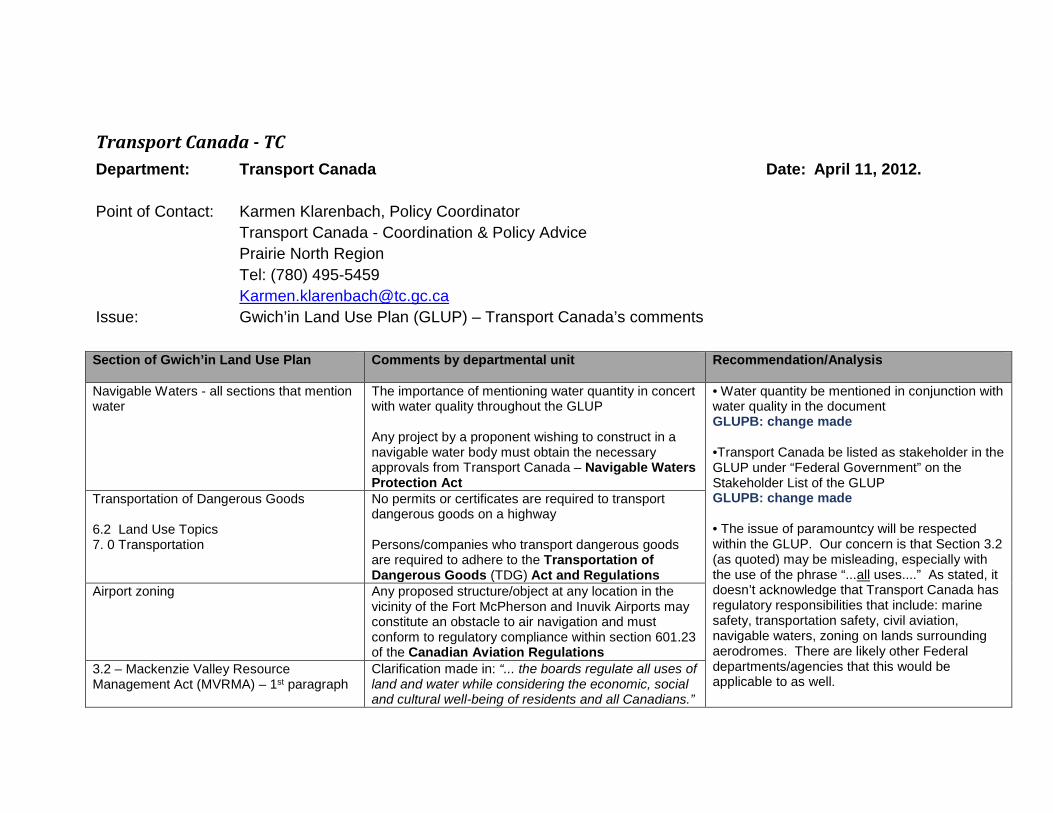
Transport Canada - TC Department: Transport Canada Date: April 11, 2012. Point of Contact: Karmen Klarenbach, Policy Coordinator
Transport Canada - Coordination & Policy Advice Prairie North Region
Tel: (780) 495-5459 [email protected] Issue: Gwich’in Land Use Plan (GLUP) – Transport Canada’s comments Section of Gwich’in Land Use Plan Comments by departmental unit Recommendation/Analysis
Navigable Waters - all sections that mention water
The importance of mentioning water quantity in concert with water quality throughout the GLUP Any project by a proponent wishing to construct in a navigable water body must obtain the necessary approvals from Transport Canada – Navigable Waters Protection Act
• Water quantity be mentioned in conjunction with water quality in the document GLUPB: change made •Transport Canada be listed as stakeholder in the GLUP under “Federal Government” on the Stakeholder List of the GLUP GLUPB: change made • The issue of paramountcy will be respected within the GLUP. Our concern is that Section 3.2 (as quoted) may be misleading, especially with the use of the phrase “...all uses....” As stated, it doesn’t acknowledge that Transport Canada has regulatory responsibilities that include: marine safety, transportation safety, civil aviation, navigable waters, zoning on lands surrounding aerodromes. There are likely other Federal departments/agencies that this would be applicable to as well.
Transportation of Dangerous Goods 6.2 Land Use Topics 7. 0 Transportation
No permits or certificates are required to transport dangerous goods on a highway Persons/companies who transport dangerous goods are required to adhere to the Transportation of Dangerous Goods (TDG) Act and Regulations
Airport zoning
Any proposed structure/object at any location in the vicinity of the Fort McPherson and Inuvik Airports may constitute an obstacle to air navigation and must conform to regulatory compliance within section 601.23 of the Canadian Aviation Regulations
3.2 – Mackenzie Valley Resource Management Act (MVRMA) – 1st paragraph
Clarification made in: “... the boards regulate all uses of land and water while considering the economic, social and cultural well-being of residents and all Canadians.”

- 44 -
Section of Gwich’in Land Use Plan Comments by departmental unit Recommendation/Analysis
GLUPB: changed to regulate “...the use...” instead of “...all uses...” •Transport Canada be listed as a Regulatory Agency in Appendix C that includes the areas in which they have authorization and the associated legislation and regulation over which they have authorization – listed on the following page GLUPB: Appendix C moved into revised section 3.2 Regulation. Trying to keep table to one page, and establish that it isn’t comprehensive. Regulators or authorisations might change in between Plan revisions. Did include Transport Canada regulatory responsibilities in paragraph 2, page 38 as an example of an additional regulatory authority to provide emphasis on the list not being comprehensive. The Planning Board made every effort to determine “every body having authority under any federal or territorial law to issue licences, permits or other authorizations relating to the use of land or waters or the deposit of waste” but are not certain we have.
Regulatory Agency Authorization Associated Legislation/regulation
Transport Canada
•Approval of any type of work in, on, over, under, through or across a navigable waterway to protect the public’s constitutional right to navigation
Navigable Waters Protection Act (Navigation Protection Act)
Transportation of Dangerous Goods on a highway Transportation of Dangerous Goods (TDG) Act and Regulations
Any proposed structure that may interfere or constitute an obstacle to air navigation
Canadian Aviation Regulations (CARs)

- 45 -
Section of Gwich’in Land Use Plan Comments by departmental unit Recommendation/Analysis
Minimum altitudes for aircraft
Aeronautics Act and Canadian Aviation Regulations (CARs) – only Minister of Transport may set minimum flight altitudes for aircraft Aeronautical Information Manual (AIM) – provides guidance to pilots in relation to flight operations in special areas where safe to do so
Airport zoning regulations Aeronautics Act – Regulations relating to individual airport zoning

- 46 -
Department of Fisheries and Oceans - DFO Documents Reviewed: Gwich’in Land Use Planning Board (GLUPB). 2011a. Final Draft – October 2011: Nan Geenjit Gwitr’it T’agwaa’in: Working for the Land. Gwich’in Land Use Plan. Document Layout: Fisheries and Oceans Canada has taken a critical look through both plans to assess: 1) potential conflicts with the Fisheries Act, and 2) consistency with departmental mandates and policies.
Page(s) Topic Page Topic Issue/Concern Recommendation/Comment 62, 65, 67, 71, 73, 76, 78, 81, 85, 91, 94, 97, 100, & 102
“Condition Regarding Fish” The onus of proof that no negative impacts on fish habitat or impediments to the movement of fish will occur should be the responsibility of the proponent. Likewise, the proponent should assist in establishing peak migration times for fish.
To clarify the responsibility of the proponent, please reword condition to: During peak migration times in the spring and fall, new activities requiring a permit, license or authorization will not be allowed unless it is demonstrated by the proponent that no negative impacts on fish habitat or impediments to the movement of fish will occur. Peak migration times for fish will be established by the proponent with concurrence by the Gwich’in Renewable Resource Board, the Department of Fisheries and Oceans, the (local) Gwich’in Renewable Resource Council(s).
GLUPB Response: Change made
Appendix C Authorizations subject to the LUP – Corrections
DFO issues authorizations for impacts to fish and fish habitat resulting from the works, undertakings, operations or activities associated with proposed
Replace ‘Habitat Alteration, Disruption or Destruction Authorization’ with ‘Authorization for impacts to fish and fish habitat resulting from the works, undertakings, operations

- 47 -
Page(s) Topic Page Topic Issue/Concern Recommendation/Comment development. This includes the harmful alteration, disruption or destruction of fish habitat pursuant to subsection 35(2) and the destruction of fish pursuant to section 32 of the Fisheries Act.
or activities associated with proposed development’
GLUPB Response: Change made
Throughout General The Department of Fisheries and Oceans should be referred to as Fisheries and Oceans Canada. The departmental acronym is still DFO
Replace all occurrences of the ‘Department of Fisheries and Oceans’ with ‘Fisheries and Oceans Canada’
GLUPB Response: Change made
52 Species at Risk The proponents should also consult with Fisheries and Oceans Canada to ensure there are no listed fish species at risk
Include Fisheries and Oceans Canada in the list of departments, boards and councils that the proponent should contact to determine what species at risk that could be in the vicinity
GLUPB Response: Change made

- 48 -
Page(s) Topic Page Topic Issue/Concern Recommendation/Comment 56 Management zone table Fish habitat is present and it’s
protection is a concern for every area. This includes Cardinal Lake, Tsiigehnjik gwitl'it (headwaters of the Arctic Red River) and the three Transportation Routes (as the roads involve numerous stream crossings)
Please consider checking off fish habitat for: Cardinal Lake, Tsiigehnjik gwitl'it (headwaters of the Arctic Red River) and the three Transportation routes
GLUPB Response: Will add to the Regional Plan of Action to explore changing to a regional condition. Fish will still be considered in the regulatory process under existing regulations in the interim.