Embed Size (px)
Citation preview
MAXIMIZE THE VALUE OF YOUR MINE
北 京 盛 科 瑞 仪 器 有 限 公 司B e i j i n g S C R I n s t r u m e n t s L t d
GeoSLAM ZEB-REVO Applications to Underground Mining in China
MAXIMIZE THE VALUE OF YOUR MINE北 京 盛 科 瑞 仪 器 有 限 公 司B e i j i n g S C R I n s t r u m e n t s L t d
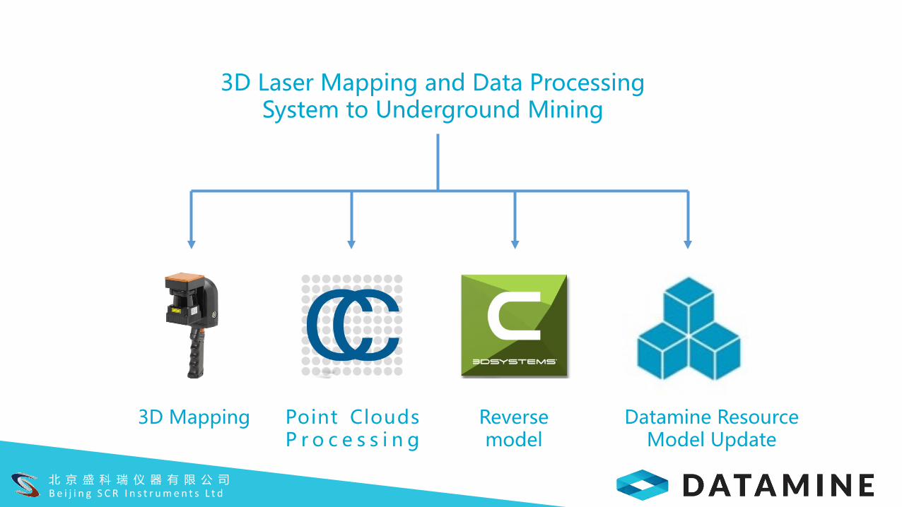
3D Laser Mapping and Data Processing System to Underground Mining
3D Mapping Point CloudsP r o c e s s i n g
Reverse model
Datamine Resource Model Update
MAXIMIZE THE VALUE OF YOUR MINE北 京 盛 科 瑞 仪 器 有 限 公 司B e i j i n g S C R I n s t r u m e n t s L t d
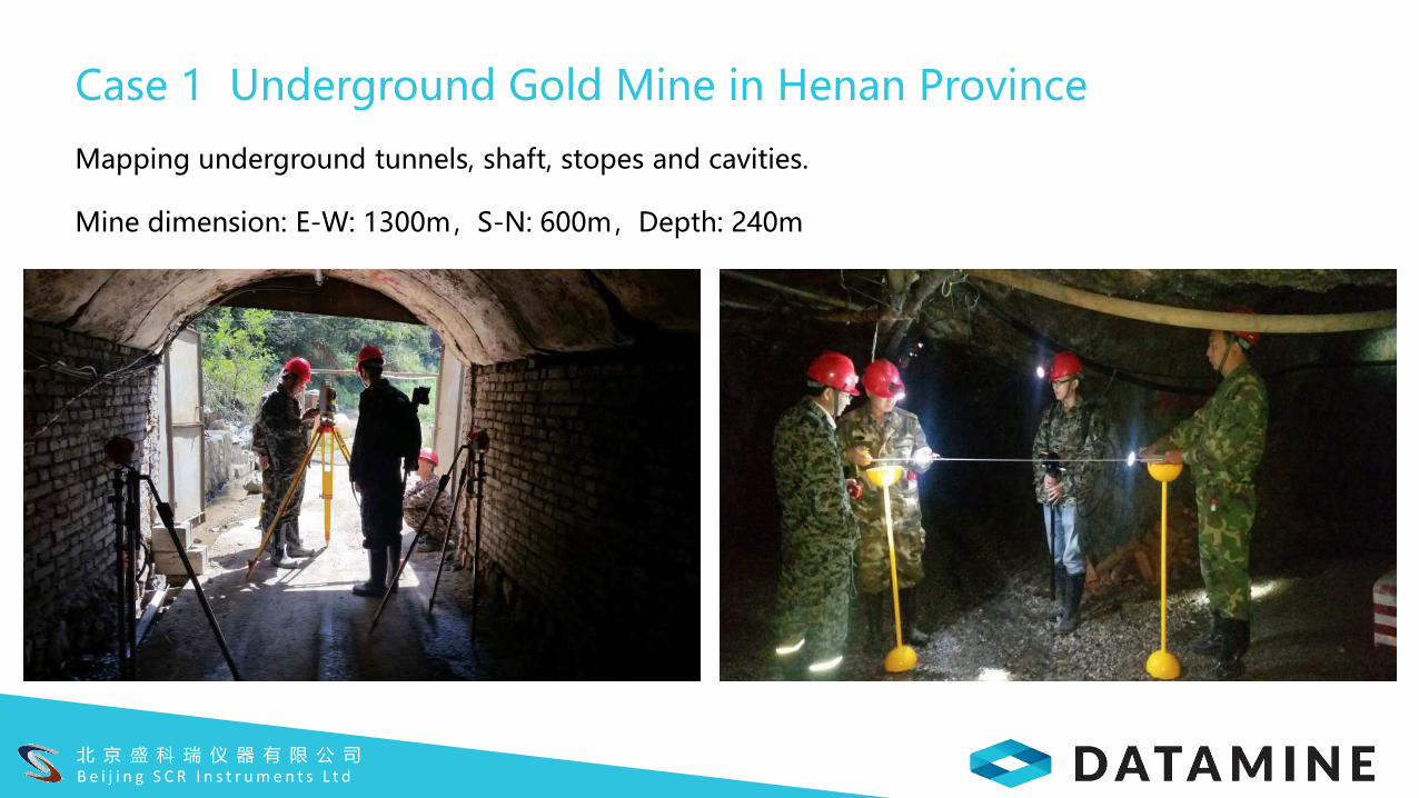
Case 1 Underground Gold Mine in Henan Province
Mapping underground tunnels, shaft, stopes and cavities.
Mine dimension: E-W: 1300m,S-N: 600m,Depth: 240m

北京盛科瑞仪器有限公司
MAXIMIZE THE VALUE OF YOUR MINE北 京 盛 科 瑞 仪 器 有 限 公 司B e i j i n g S C R I n s t r u m e n t s L t d
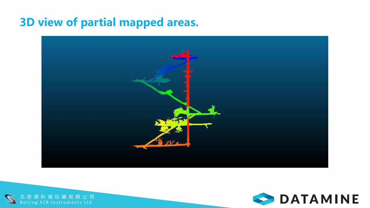
3D view of partial mapped areas.

MAXIMIZE THE VALUE OF YOUR MINE北 京 盛 科 瑞 仪 器 有 限 公 司B e i j i n g S C R I n s t r u m e n t s L t d
Whole mapped underground spaces
Days for on-site mapping:6
Days for data processing:3

MAXIMIZE THE VALUE OF YOUR MINE北 京 盛 科 瑞 仪 器 有 限 公 司B e i j i n g S C R I n s t r u m e n t s L t d
Reverse model of tunnels
Point cloud model
DWG model for mining design software

MAXIMIZE THE VALUE OF YOUR MINE北 京 盛 科 瑞 仪 器 有 限 公 司B e i j i n g S C R I n s t r u m e n t s L t d
Cavities
Point clouds
Wireframe models

北 京 盛 科 瑞 仪 器 有 限 公 司B e i j i n g S C R I n s t r u m e n t s L t d
Calculate volume for backfill design
Volume Calculation

MAXIMIZE THE VALUE OF YOUR MINE北 京 盛 科 瑞 仪 器 有 限 公 司B e i j i n g S C R I n s t r u m e n t s L t d
With 3D spatial
information, geologists
would be able to study
more insight into resource
models and might be able
to identify residual
resources. This is especially
valuable for precious metal
deposits.
Optimizing Resource Model

MAXIMIZE THE VALUE OF YOUR MINE北 京 盛 科 瑞 仪 器 有 限 公 司B e i j i n g S C R I n s t r u m e n t s L t d
Resource models vs actually minedCase 2
MAXIMIZE THE VALUE OF YOUR MINE北 京 盛 科 瑞 仪 器 有 限 公 司B e i j i n g S C R I n s t r u m e n t s L t d
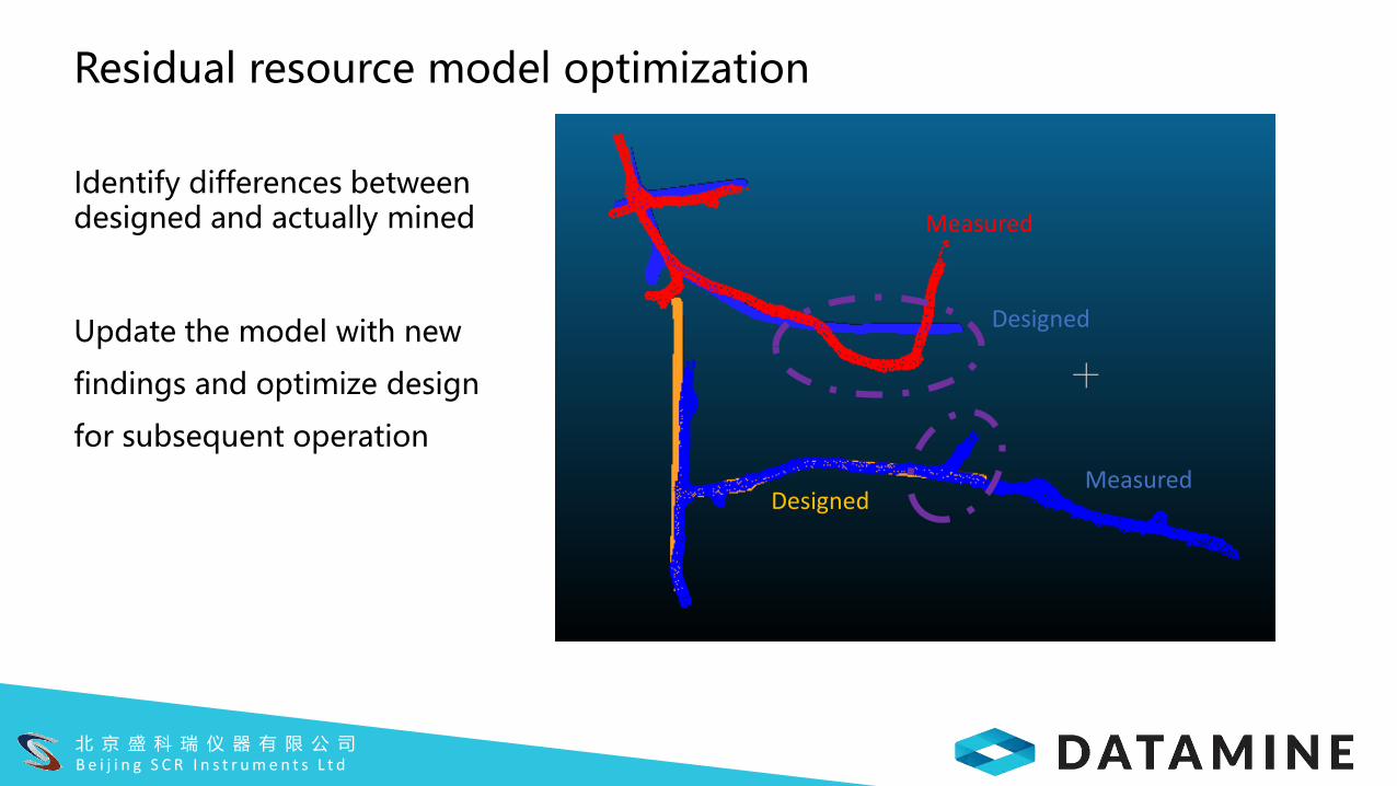
Residual resource model optimization
Identify differences between designed and actually mined
Update the model with new
findings and optimize design
for subsequent operation
Designed
Designed
Measured
Measured

北 京 盛 科 瑞 仪 器 有 限 公 司B e i j i n g S C R I n s t r u m e n t s L t d
Case 3 Safety and volume inspections
Sections 470 and 495
Nine sub-sectional scans
Total time: 3 hrs
Total 260 million points
北 京 盛 科 瑞 仪 器 有 限 公 司B e i j i n g S C R I n s t r u m e n t s L t d
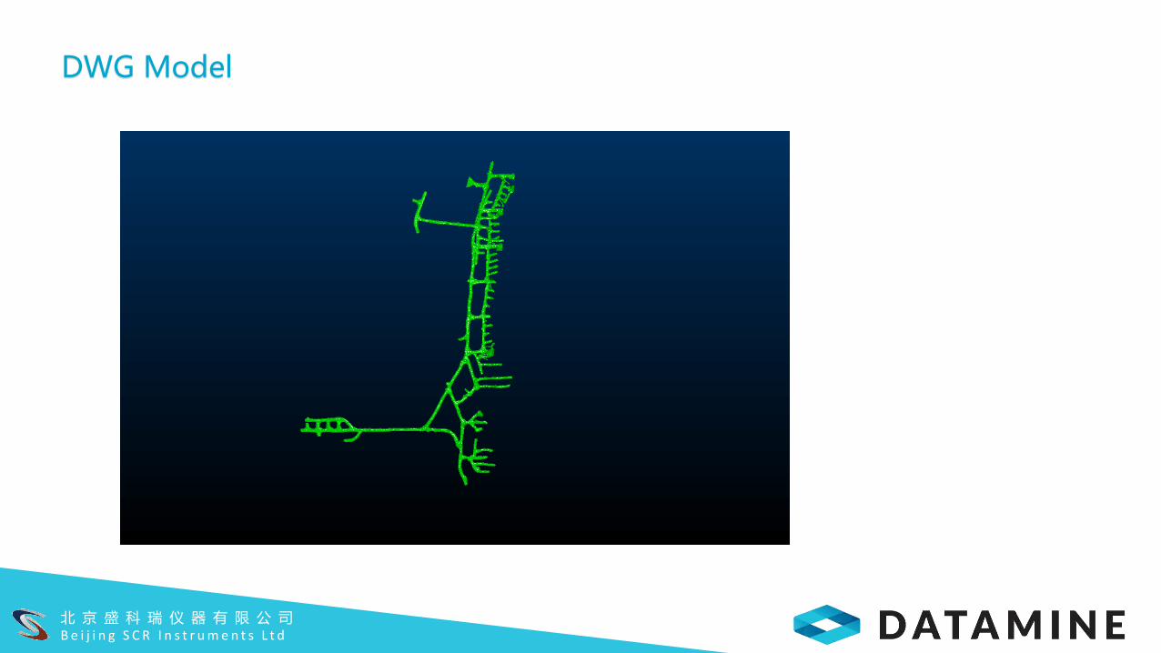
DWG Model
北 京 盛 科 瑞 仪 器 有 限 公 司B e i j i n g S C R I n s t r u m e n t s L t d
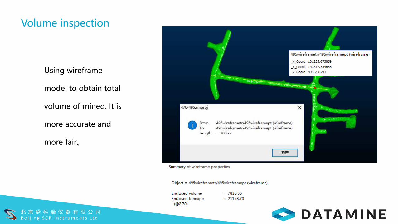
Volume inspection
Using wireframe
model to obtain total
volume of mined. It is
more accurate and
more fair。
北 京 盛 科 瑞 仪 器 有 限 公 司B e i j i n g S C R I n s t r u m e n t s L t d
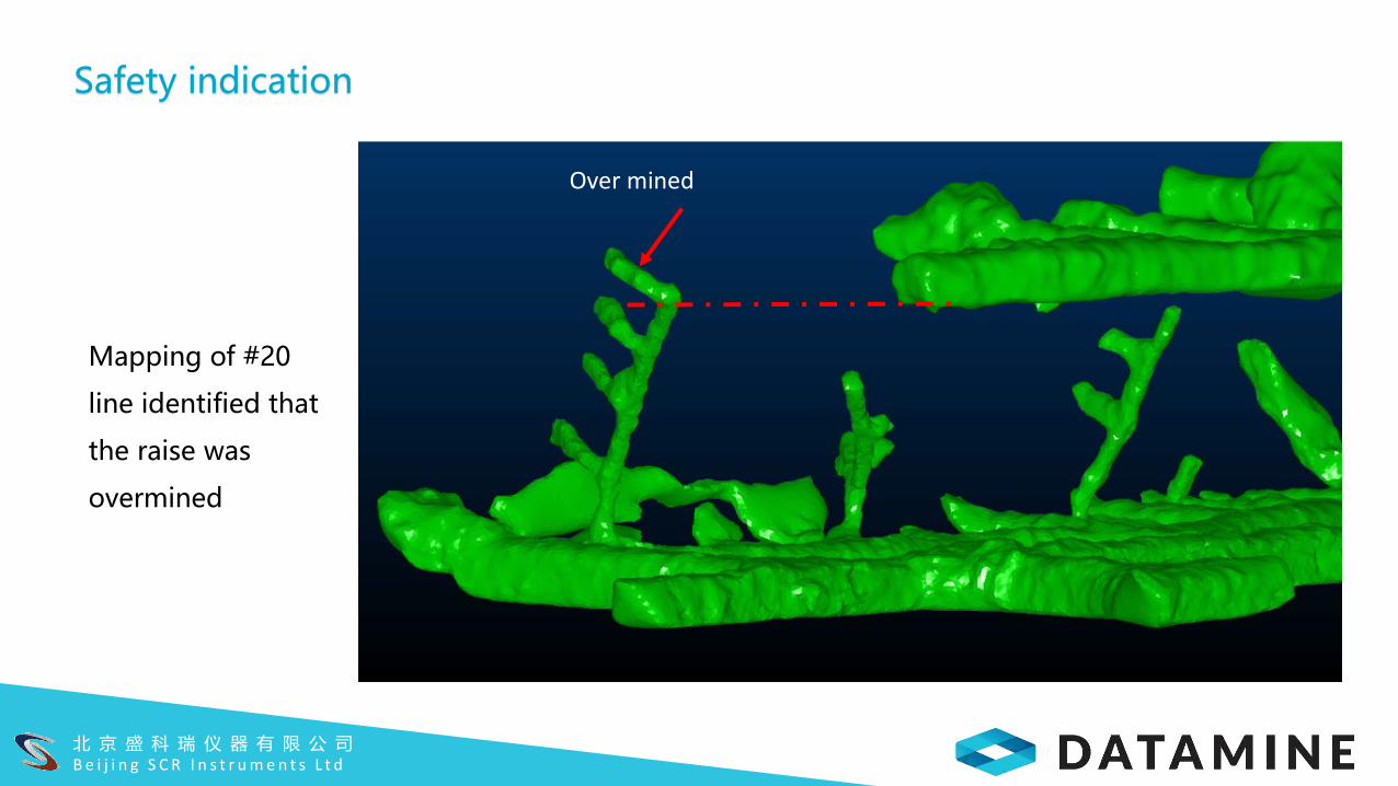
Safety indication
Mapping of #20
line identified that
the raise was
overmined
Over mined
北 京 盛 科 瑞 仪 器 有 限 公 司B e i j i n g S C R I n s t r u m e n t s L t d
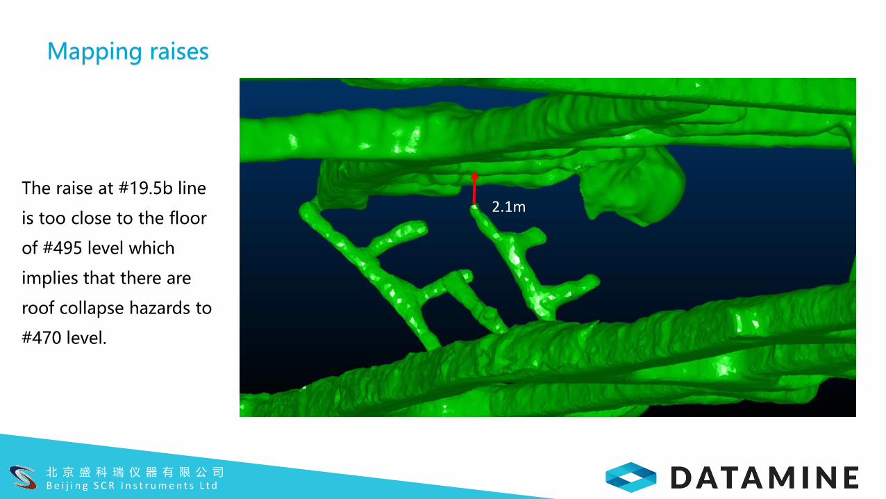
Mapping raises
The raise at #19.5b line
is too close to the floor
of #495 level which
implies that there are
roof collapse hazards to
#470 level.
2.1m

北 京 盛 科 瑞 仪 器 有 限 公 司B e i j i n g S C R I n s t r u m e n t s L t d
Compare with total station survey data
REVO data are
quite close to total
station data from
CAD for #495 level。
Water inundated
at the time of
mapping
Total station surveyed
boundary
A
A

北 京 盛 科 瑞 仪 器 有 限 公 司B e i j i n g S C R I n s t r u m e n t s L t d
Inspection
At #470 Level, REVO data are
very close with total station data
for main galleries, but not very
close to access tunnels to
stopes, which were mainly
measured using compasses and
tape measures.
罗盘测量产生误差
C
B B
C

北 京 盛 科 瑞 仪 器 有 限 公 司B e i j i n g S C R I n s t r u m e n t s L t d
斜坡道 A-A 穿脉 C-C
沿脉 B-B
Total station survey points in line with sectional boundary from REVO data
4.489m
4.884m
4.608m
4.671m
3.965m
Total Station Surveying Points

北 京 盛 科 瑞 仪 器 有 限 公 司B e i j i n g S C R I n s t r u m e n t s L t d
Case 4 Orepass Shaft Mapping
Depth:110m
Mapping time: 30 mins
Data Processing time: 30 mins
罗盘测量产生误差

北 京 盛 科 瑞 仪 器 有 限 公 司B e i j i n g S C R I n s t r u m e n t s L t d
Case 5 Large cavities (needs for long range scanners and/or UAVs)
罗盘测量产生误差

北 京 盛 科 瑞 仪 器 有 限 公 司B e i j i n g S C R I n s t r u m e n t s L t d
Summaries
REVO, as a new surveying tool, offers very fast and efficient 3D mapping for
underground mines.
It is especially suitable for complex 3D spaces, shafts, raises, ore passes and their
combinations.
It is very easy to use and can be operated by one person.
It offers high density of point clouds which reflects underground spaces in details.
Fast built 3D models could be read directly by most mining design which facilitate
mine design and management.

北 京 盛 科 瑞 仪 器 有 限 公 司B e i j i n g S C R I n s t r u m e n t s L t d
Summaries (Cont.)
It could be used in daily operation for volume inspection, if it is over- or under-
mined for fair auditing.
It could be used to check if there are safety issues.
Data could be used for optimizing resource models, calculating volume of cavities
for backfill design.
Looking forward to seeing a long range REVO for thorough mapping of large
cavities.

北 京 盛 科 瑞 仪 器 有 限 公 司B e i j i n g S C R I n s t r u m e n t s L t d
Thank You!

北 京 盛 科 瑞 仪 器 有 限 公 司B e i j i n g S C R I n s t r u m e n t s L t d
Over 20 Mining shows and exhibitions participated
40-50 individual demos run
15 systems purchased from Geoslam
3 demo systems