Embed Size (px)
Citation preview
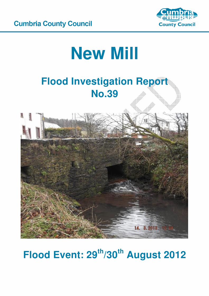
New Mill
Flood Investigation Report
No.39
Flood Event: 29th
/30th
August 2012

Cumbria County Council
2 Serving the people of Cumbria
This flood investigation report has been produced by Cumbria County Council as a Lead Local
Flood Authority under Section 19 of the Flood and Water Management Act 2010.
Version
Undertaken by
Reviewed by
Approved by
Date
Preliminary
David White Anthony Lane
20 Nov 2013
Final Draft
Andrew Harrison Anthony Lane
28 Feb 2014
Published
Andrew Harrison Anthony Lane Doug Coyle 9th April 2014

cumbria.gov.uk 3
Contents Executive Summary .................................................................................................................................................... 4
Event Background ...................................................................................................................................................... 5
Flooding Incident .......................................................................................................................................................... 5
Investigation ................................................................................................................................................................ 7
Map of Flow Routes ...................................................................................................................................................... 7
Likely Causes of Flooding ............................................................................................................................................. 8
Rainfall Event ................................................................................................................................................................ 9
Flooding History ............................................................................................................................................................ 9
Recommended Actions ............................................................................................................................................ 10
Next Steps ................................................................................................................................................................. 11
Appendices ................................................................................................................................................................ 12
Appendix 1: Glossary .................................................................................................................................................. 12
Appendix 2: Summary of Relevant Legislation and Flood Risk Management Authorities ......................................... 13
Appendix 3: Useful contacts and links ........................................................................................................................ 16
Appendix 4: Effect of Pond at Ponsonby Old Hall ...................................................................................................... 17
Figures Figure 1. Location Plan. .............................................................................................. Error! Bookmark not defined.
Figure 2. New Mill location plan ................................................................................................................................... 6
Figure 3. New Mill topography plan ............................................................................................................................. 6
Figure 4. Property locations ......................................................................................................................................... 7
Figure 5. Flood routes .................................................................................................................................................. 8
Figure 6 Ponsonby Old Hall ...................................................................................................................................... 17
Cumbria County Council
4 Serving the people of Cumbria
Executive Summary
Cumbria County Council as Lead Local Flood Authority has prepared this report with the
assistance of other Flood Risk Management Authorities as it considers necessary to do so
under Section 19 of the Flood and Water Management Act 2010.
Some of the properties in the hamlet of Newmill suffered internal and external flooding during
the excessive rainfall event of the 30th August 2012. The main source of the flooding was
fluvial. The mechanism was insufficient capacity in the Newmill Beck and associated culverts in
the hamlet.
6 actions have been identified within the report that would reduce the risk of future flooding.
These include improvements in culvert capacity, encouraging landowners to maintain
watercourses and investigating options for reducing flows in the Beck.

cumbria.gov.uk 5
Event Background
This section describes the location of the flood incident and identifies the properties that were
flooded.
Flooding Incident
New Mill
Figure 1. Location Plan.
The hamlet of New Mill is on the A595 highway (see Figure 1 “Location Plan”), which runs along
the boundary of the Lake District National Park. At its centre is a culvert carrying Newmill Beck
under the A595. The Beck rises at the foot of the Copeland Forest fells and upstream of the
culvert has a catchment of about 550 hectares. Figure 3, “New Mill topography plan” shows
that it flows down a steep valley. About 900m downstream of the bridge, the Beck discharges
into the Ponsonby Tarn. The Newmill Beck then flows out of the Tarn before discharging into
the sea about 3½ km southwest of New Mill.

Cumbria County Council
6 Serving the people of Cumbria
New Mill
Figure 2. New Mill location plan
80 90 100 110 120 130 140
Ponsonby Tarn 80 A595 90 Newmill Beck 100 110
Figure 3. New Mill topography plan

cumbria.gov.uk 7
Investigation
Internal flooding of Swallow’s Nest at New Mill was reported to the Environment Agency
Incident Room on the 29th August 2012.
A flood incident site investigation was carried out by Copeland District Council and Cumbria
County Council.
Map of Flow Routes Smithy Cottage The Old Mill Swallow’s Nest
New Mill Cottages Newmill Beck A595
Figure 4. Property locations
Figure 4 “Property locations” shows the properties known to have had flooding problems as
Newmill Beck burst its banks. The width of the flow increased (see Figure 5 “Flood routes”)
flooding Swallow’s Nest and New Mill Cottages. Swallows Nest flooded internally and its
access drive was broken up by the flood debris. A decking platform in the garden of Fussell
New Mill Cottage was lifted and there was about 1.2m of water in a workshop. The cellar in
Broadbent New Mill Cottage next door was also flooded. There is a danger that the outlet to the
cottages’ septic tank may become blocked by debris during such flood events. Further
investigations revealed that the cellar of Orchard View flooded and substantial garden damage
also occurred.
Location of 1.35m dia. culvert for
agricultural crossing

Cumbria County Council
8 Serving the people of Cumbria
surcharged culvert flow Swallow’s Nest extent of flood septic tank outlet main flow route out of beck
southern parapet northern parapet Broadbent New Mill Cottage Fussell New Mill Cottage A595
Figure 5. Flood routes
Likely Causes of Flooding
New Mill Cottages are in fluvial Flood Zones 2 and 3. It is understood that the Newmill Beck
was in need of some maintenance and it was unable to contain the excessive flow. Also the
culvert running under the A595 did not have sufficient capacity for the flow causing a surcharge
flow over the highway to the north-west of the crossing.
Some of the surcharged flow from the culvert re-entered the Beck through a hole in the
southern stone parapet wall. The northern stone parapet wall is continuous. It has been
suggested that if a similar hole is introduced through the northern parapet wall, then a route
could be provided for flood waters across the highway when the Beck is in flood. This could
result in litigation claims if any road traffic accidents occurred as a result of highway flooding. A
proposal to build a wall at Swallow’s Nest to protect the property from future flooding could also
increase the risk of future flooding to other properties adjacent to the Beck. The highway culvert
is 2.2m x 0.8m = 1.76m² in size at the upstream end and is 2.0m x 0.8m = 1.6m² at the
downstream outlet. This is further reduced by the angle of the wing wall taking the outlet to 1.6m
x 0.8m =1.28m².
Approximately 10m further downstream of Orchard View there is a culvert that has been built
from 1.35m diameter (1.43m²) concrete manhole rings with step irons still in situ. This has been
introduced to accommodate an agricultural crossing over the Beck. It is marginally larger than

cumbria.gov.uk 9
the downstream end of the A595 culvert. There is another water course entering the Beck
downstream of the A595 culvert but above the agricultural crossing. Anecdotal evidence
suggests a large tree stump had partially blocked the agricultural crossing. There is also a large
overflow pipe approx. 450mm diameter above the agricultural culvert but this could not cope
with the sheer volume of water due to the blockage.
Upstream of New Mill, the Beck has a tributary that connects it to Scargreen Beck, which is a
tributary of the River Calder. Newmill Beck itself continues up to Boonwood to rise at Bleng
Fell. The catchment of this watercourse system should be investigated to see if any changes
have been made and to consider upstream attenuation opportunities. About 15 years ago Nirex
diverted the Beck at Boonwood. There have not been any reports of flooding problems
associated with the River Calder so any connections made to Newmill Beck could be severed or
limited.
Rainfall Event
There were many rainfall events during the month of August in 2012, with events lasting almost
continuously up to 12 hours. The weather radar indicated that there was rain almost every day
over the Gosforth area in the second half of the month. On the 29th it rained intermittently from
about 1:40am until about 1:50pm. It is likely that the ground was reaching saturation point.
Rainfall radar records indicate that at approximately 9:00pm on the evening of the 29th August, it
started to rain heavily and did not stop until around 3:40am on the 30th August. This rainfall
event peaked at about 00:35am with an intensity of up to 50mm/hr. and then again at 1:20am.
Intensities above 20mm/hr. are considered to be heavy rainfall.
Flooding History
Flooding has occurred relatively recently in New Mill.
Cumbria County Council
10 Serving the people of Cumbria
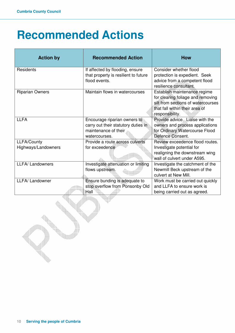
Recommended Actions
Action by
Recommended Action
How
Residents If affected by flooding, ensure
that property is resilient to future
flood events.
Consider whether flood
protection is expedient. Seek
advice from a competent flood
resilience consultant.
Riparian Owners Maintain flows in watercourses Establish maintenance regime
for clearing foliage and removing
silt from sections of watercourses
that fall within their area of
responsibility.
LLFA Encourage riparian owners to
carry out their statutory duties in
maintenance of their
watercourses.
Provide advice. Liaise with the
owners and process applications
for Ordinary Watercourse Flood
Defence Consent.
LLFA/County
Highways/Landowners
Provide a route across culverts
for exceedence
Review exceedence flood routes.
Investigate potential for
realigning the downstream wing
wall of culvert under A595.
LLFA/ Landowners Investigate attenuation or limiting
flows upstream.
Investigate the catchment of the
Newmill Beck upstream of the
culvert at New Mill.
LLFA/ Landowner Ensure bunding is adequate to
stop overflow from Ponsonby Old
Hall
Work must be carried out quickly
and LLFA to ensure work is
being carried out as agreed.

cumbria.gov.uk 11
Next Steps
CCC as the LLFA will continue to ensure that any actions identified within the actions table of
this report are appropriately taken forward by each Risk Management Authority identified.
Actions will continue to be prioritised through the Making Space for Water process and
monitored through regular meetings of the group. Details of the MSfWG members and
summary of related processes are detailed in Appendix 2.

Cumbria County Council
12 Serving the people of Cumbria
Appendices
Appendix 1: Glossary Acronyms EA Environment Agency CCC Cumbria County Council LLFA Lead Local Flood Authority LFRM Local Flood Risk Management MSfWG Making Space for Water Group FAG Flood Action Group

cumbria.gov.uk 13
Appendix 2: Summary of Relevant Legislation and Flood
Risk Management Authorities
The Flood Risk Regulations 1999 and the Flood and Water Management Act 2010 (the Act) have established Cumbria County Council (CCC) as the Lead Local Flood Authority (LLFA) for Cumbria. This has placed various responsibilities on CCC including Section 19 of the Act which states: Section 19 (1) On becoming aware of a flood in its area, a lead local flood authority must, to the extent that
it considers it necessary or appropriate, investigate— (a) which risk management authorities have relevant flood risk management functions,
and (b) whether each of those risk management authorities has exercised, or is proposing to
exercise, those functions in response to the flood. (2) Where an authority carries out an investigation under subsection (1) it must—
(a) publish the results of its investigation, and (b) notify any relevant risk management authorities.
A ‘Risk Management Authority’ (RMA) means:
(a) the Environment Agency, (b) a lead local flood authority, (c) a district council for an area for which there is no unitary authority, (d) an internal drainage board, (e) a water company, and (f) a highway authority.
The table below summarises the relevant Risk Management Authority and details the various local source of flooding that they will take a lead on. Flood Source
Environment Agency
Lead Local Flood Authority
District Council
Water Company
Highway Authority
RIVERS Main river Ordinary watercourse
SURFACE RUNOFF
Surface water
Surface water on the highway
OTHER Sewer flooding
The sea
Groundwater Reservoirs
Cumbria County Council
14 Serving the people of Cumbria
The following information provides a summary of each Risk Management Authority’s roles and responsibilities in relation to flood reporting and investigation. Government – Defra develop national policies to form the basis of the Environment Agency’s and Cumbria County Council’s work relating to flood risk. Environment Agency has a strategic overview of all sources of flooding and coastal erosion as defined in the Act. As part of its role concerning flood investigations this requires providing evidence and advice to support other risk management authorities. The EA also collates and reviews assessments, maps and plans for local flood risk management (normally undertaken by LLFA). Lead Local Flood Authorities (LLFAs) – Cumbria County Council is the LLFA for Cumbria. Part of their role requires them to investigate significant local flooding incidents and publish the results of such investigations. LLFAs have a duty to determine which risk management authority has relevant powers to investigate flood incidents to help understand how they happened, and whether those authorities have or intend to exercise their powers. LLFAs work in partnership with communities and flood risk management authorities to maximise knowledge of flood risk to all involved. This function is carried out at CCC by the Local Flood Risk Management Team. District and Borough Councils – These organisations perform a significant amount of work relating to flood risk management including providing advice to communities and gathering information on flooding. Water and Sewerage Companies manage the risk of flooding to water supply and sewerage facilities and the risk to others from the failure of their infrastructure. They make sure their systems have the appropriate level of resilience to flooding and where frequent and severe flooding occurs they are required to address this through their capital investment plans. It should also be noted that following the Transfer of Private Sewers Regulations 2011 water and sewerage companies are responsible for a larger number of sewers than prior to the regulation. Highway Authorities have the lead responsibility for providing and managing highway drainage and certain roadside ditches that they have created under the Highways Act 1980. The owners of land adjoining a highway also have a common-law duty to maintain ditches to prevent them causing a nuisance to road users. Flood risk in Cumbria is managed through the Making Space for Water process which involves the cooperation and regular meeting of the Environment Agency, United Utilities, District/Borough Councils and CCC’s Highway and LFRM Teams to develop processes and schemes to minimise flood risk. The MSfWGs meet approximately 4 times per year to cooperate and work together to improve the flood risk in the vulnerable areas identified in this report by completing the recommended actions. CCC as LLFA has a responsibility to oversee the delivery of these actions. Where minor works or quick win schemes can be identified, these will be prioritised and subject to available funding and resources will be carried out as soon as possible. Any major works requiring capital investment will be considered through the Environment Agency’s Medium Term Plan or a partners own capital investment process.

cumbria.gov.uk 15
Flood Action Groups are usually formed by local residents who wish to work together to resolve flooding in their area. The FAGs are often supported by either CCC or the EA and provide a useful mechanism for residents to forward information to the MSfWG.
Cumbria County Council
16 Serving the people of Cumbria
Appendix 3: Useful contacts and links
To report flooding: Incident hotline tel. 0800 80 70 60 (24hrs)
Floodline: tel. 0845 988 1188
Cumbria County Council (Local Flood Risk Management):
[email protected], www.cumbria.gov.uk, tel: 01228 221330
Cumbria County Council (Highways):
[email protected], www.cumbria.gov.uk, tel: 0845 609 6609
Cumbria County Council Neighbourhood Forum: tel. 01946 505022
Cumbria.gov.uk/sayit
United Utilities: tel: 0845 746 2200
Copeland Borough Council
[email protected], www.copeland.gov.uk, tel. 0845 054 8600
Flood and Water Management Act 2010:
http://www.legislation.gov.uk/ukpga/2010/29/contents
Water Resources Act 1991:
http://www.legislation.gov.uk/all?title=water%20resources%20act
Land Drainage Act:
http://www.legislation.gov.uk/all?title=land%20drainage%20act
Highways Act 1980:
http://www.legislation.gov.uk/all?title=highways%20act
EA – ‘Living on the Edge’ a guide to the rights and responsibilities of riverside occupation:
http://www.environment-agency.gov.uk/homeandleisure/floods/31626.aspx
EA – ‘Prepare your property for flooding’ how to reduce flood damage including flood
protection products and services:
http://www.environment-agency.gov.uk/homeandleisure/floods/31644.aspx
cumbria.gov.uk 17
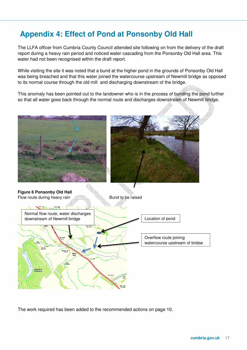
Appendix 4: Effect of Pond at Ponsonby Old Hall
The LLFA officer from Cumbria County Council attended site following on from the delivery of the draft
report during a heavy rain period and noticed water cascading from the Ponsonby Old Hall area. This
water had not been recognised within the draft report.
While visiting the site it was noted that a bund at the higher pond in the grounds of Ponsonby Old Hall
was being breached and that this water joined the watercourse upstream of Newmill bridge as opposed
to its normal course through the old mill and discharging downstream of the bridge.
This anomaly has been pointed out to the landowner who is in the process of bunding the pond further
so that all water goes back through the normal route and discharges downstream of Newmill bridge.
Figure 6 Ponsonby Old Hall
Flow route during heavy rain Bund to be raised
The work required has been added to the recommended actions on page 10.
Location of pond
Overflow route joining
watercourse upstream of bridge
Normal flow route, water discharges
downstream of Newmill bridge

Cumbria County Council
18 Serving the people of Cumbria
cumbria.gov.uk