Embed Size (px)
Citation preview

Flooding in urban area – HochiminhCity, Vietnam: Disaster risk response
1

2

Dong NaiSaigon
Vam Co
sea level
Rain
3

4

Phu My Hung, District 7
Urban slum along Nhieu Loc –
Thi Nghe Canal
Picture took from a.
ashui.com, b by Ngụy Hà.
5

http://www.phongchonglutbaotphcm.gov.vn/?id=27&cid=312
2007Flooding map, HCMC
6

Dyke system surrounding HCMC
7

8

9

Ho Chi Minh City Inundation Problem
1. land subsidence (2-3 cm/yr) impeded drainage
2. higher tides (< 1 cm/yr) impeded drainage
3. less room for river, higher discharge higher river water levels impeded drainage
4. increased rainfall & insufficient sewer system insufficientdrainage
5. intensifying economy increasing damage
Royal-Haskoning interim study report (2012). 10

Count of flood events in HCMC
Philip Bubeck, Flood damage and risk assessment for Ho Chi Minh City
11

Drainage system
• The drainage system in HCMC is a combined drainage system for domestic wastewater, rain water and industrial wastewater.
• The drainage system in urban areas severely degraded, only meet 60% the drainage needs (TH Nhue, 2011).
• 50% damaged sewers, 30% degraded sewers, only about 20% of new sewers still good conditions
• The drainage system in the HCMC is “out of date” compare with the heavy rain and high tides (TH Nhue, 2011).
12

13

Reservoirs in Sai Gon –Dong Nai River Basin
14
Flood damage
• Direct tangible vs. Direct intangible
• Indirect tangible vs. Indirect intangible
15

Flooding situation in HCMC from 1999 to 2013
• From 1999 to now, water level increased significantly, from 1.22 m to 1.55 m.
• High tides on 3/2005 and 3/2006 broked the protective dykes and caused flooding in several districts in HCMC (inundation depth until 1.5 m).
• Specifically on 2013, water level in HCMC reached 1.64 m, 2 cm higher than highest water level in 2012 large damage.
16

Flooding in HCMC in 2013Description
• At the end of October, November and beginning of December 2013, high tide in HCMC excess alarming level III, cause severe flooding in low lying areas, areas along canals and river
• 20 October 2013, highest water level reached 1.68m – highest level over the historical 61 years
• 5-6 December 2013, highest water level reached 1.63 – 1.65 m, breaking many parts of protective dykes, cause inundation over many roads inside the city (Thoitiet, 2013).
17

18

Damages from Flooding 2013
• Historically highest tide on 20/10/2013 broke a section of protective dyke at ward 28, BinhThanh District
• This flood pass over almost protective dykes at suburban area of HCMC, caused large – scale inundation
• Some flood protection systems was inactive due to this historical tide
19
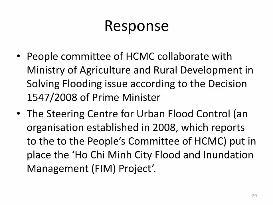
Response
• People committee of HCMC collaborate with Ministry of Agriculture and Rural Development in Solving Flooding issue according to the Decision 1547/2008 of Prime Minister
• The Steering Centre for Urban Flood Control (an organisation established in 2008, which reports to the to the People’s Committee of HCMC) put in place the ‘Ho Chi Minh City Flood and Inundation Management (FIM) Project’.
20

Responses• In particular, the city focused on building dykes
along the Saigon River and the peri-urban roads;• Building tidal control sewers at the the estuaries:
Saigon, Nha Be, Vam Co ... a total of more than 176 km dike and 13 large tidal sluices, with hundreds of small tidal sluice gates (Government Electronic Press, 2013 ).
• However, progress of the work is very slow due to difficulties in clearance.
• Some temporary solutions are also used as set in the 1200 valve to prevent tidal outlet, located 40 pumping stations with with capacity 1.000 m3 to 8.000 m3 /hour (Government Electronic Press, 2013). 21

• Regarding emergency response in the case of urban flooding recently, government, central departments and localities offices have the salvage and rescue promptly,
• Mobilized coordination between the relevant units (Municipal Public Security, the Department of Transport and Public Works, Sewerage company).
• However, because of missing of the on-site facilities and the low awareness of citizen subjective to more damage.
Individual measures were not effective.
22

Organization for DRM – 4 levels1. Ministry of Agriculture and Rural Development and the
Central Committee for Flood and Storm Control will preside over the implementation of the National Strategy for natural disaster prevention, response and mitigation
2. According to their own functions and duties, ministries, sectors and localities are responsible for effectively implementing relevant contents, objectives, duties and solutions stated in the Strategy
3. Ministry of Planning and Investment takes lead and works in collaboration with other relevant ministries and sectors to balance and arrange annual investment resources to effectively implement the Strategy.
4. People’s Committees, Committees for Flood & Storm Control and Search & Rescue at provincial and city levels steer its departments to implement the National Strategy,
23

1. Non-structural measures
a) legislation and policies
b) consolidation of organizational structures
c) Integration of DRM into planning
d) strengthening of disaster warning and forecast capacities
2. Structural measures
24

Reasons
• Not much attention paid to urban flooding problem not consider urban flooding at disaster risk
• need to balance between structure measures and non-structure measures
• To prevent urban flooding problems effectively, overall planning and comprehensive integration of climate change adaptation needs to be prioritized review
25

Thank you very much for your attention
26Future City center in 2020 (Graphic: Department of City Planning and Architecture)