Embed Size (px)
Citation preview

!!(
GalloSubstation
FIGURE 3.6-1Topographic Site MapCressey-Gallo 115 kV Power Line Project ±
!!( SubstationCressey-Gallo Power Line RouteHalf-mile Radius Around Power Line Route
Project Location
Scale:1:72,000R
0 0.25 0.5Miles
Data Source: USGS 7.5 Minute Topographic Quadrangle;Arena, Cressey, Stevinson (1987), Turlock (1976).
Map 1 of 5

FIGURE 3.6-1Topographic Site MapCressey-Gallo 115 kV Power Line Project ±
!!( SubstationCressey-Gallo Power Line RouteHalf-mile Radius Around Power Line Route
Project Location
Scale:1:72,000R
0 0.25 0.5Miles
Data Source: USGS 7.5 Minute Topographic Quadrangle;Arena, Cressey, Stevinson (1987), Turlock (1976).
Map 2 of 5

AÎE
FIGURE 3.6-1Topographic Site MapCressey-Gallo 115 kV Power Line Project ±
!!( SubstationCressey-Gallo Power Line RouteHalf-mile Radius Around Power Line Route
Project Location
Scale:1:72,000R
0 0.25 0.5Miles
Data Source: USGS 7.5 Minute Topographic Quadrangle;Arena, Cressey, Stevinson (1987), Turlock (1976).
Map 3 of 5

FIGURE 3.6-1Topographic Site MapCressey-Gallo 115 kV Power Line Project ±
!!( SubstationCressey-Gallo Power Line RouteHalf-mile Radius Around Power Line Route
Project Location
Scale:1:72,000R
0 0.25 0.5Miles
Data Source: USGS 7.5 Minute Topographic Quadrangle;Arena, Cressey, Stevinson (1987), Turlock (1976).
Map 4 of 5
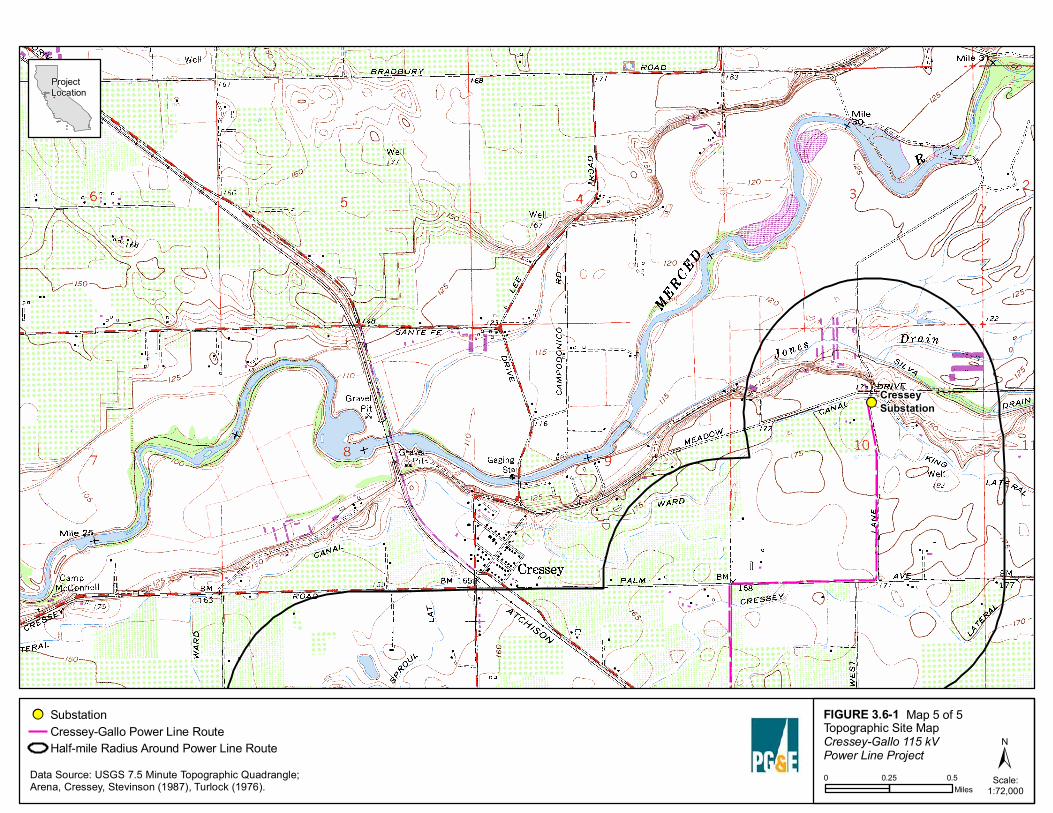
!!(CresseySubstation
FIGURE 3.6-1Topographic Site MapCressey-Gallo 115 kV Power Line Project ±
!!( SubstationCressey-Gallo Power Line RouteHalf-mile Radius Around Power Line Route
Project Location
Scale:1:72,000R
0 0.25 0.5Miles
Data Source: USGS 7.5 Minute Topographic Quadrangle;Arena, Cressey, Stevinson (1987), Turlock (1976).
Map 5 of 5

!!(
!!(
AÎE
AÎE
Merced River
MERCED COUNTY
Atwater
Delhi
Hilmar-Irwin
Livingston Winton
Turlock
CresseySubstation
GalloSubstation
FIGURE 3.6-2Geologic MapCressey-Gallo 115 kV Power Line Project ±
!!( SubstationCressey-Gallo Power Line RouteHalf-mile Radius Around Power Line RouteCity Boundary
State HighwayRoadRiver
Project Location
Scale:1:100,000R
0 1 2Miles
Data Source: Marchand D.E. and Allwardt A., Preliminary Geologic Map ShowingQuarternary Deposits of the Northeastern San Joaquin Valley, California, USGS, (1978)
Post-Modesto (Holocene)hal: alluvium; alluvial sand, silt, and gravel associated with floodplains and low terraceshed: eolian sand; associated with local modern dunesModesto Formation, Upper Member (Pleistocene)m2: coarse alluvium; alluvial sand, silt and gravel of channels, terraces, and upper fansm2b: fine alluvium; alluvial sand, silt and clay of interdistributary areas, lower fans, and floodbasins, commonly stratifiedm2e: eolian sand; associated with subdued, stabilized dunesModesto Formation, Lower Member (Pleistocene)m1: coarse alluvium; alluvial sand, silt and gravel of channels, terraces, and upper fansm1b: fine alluvium; alluvial sand, silt and clay of interdistributary areas, lower fans, and floodbasins, commonly stratifiedm1e: eolian sand; moderately well sortedRiverbank Formation, Upper Unit (Pleistocene)r3: alluvium; alluvial sand, silt, and gravelRiverbank Formation, Middle Unit (Pleistocene)r2: alluvium; alluvial sand, silt and gravelRiverbank Formation, Lower Unit (Pleistocene)r1: alluvium; alluvial sand, silt and gravelTurlock Lake Formation, Upper Unit (Pleistocene)t1: arkosic alluvium; alluvial granitic sand and minor gravelTurlock Lake Formation, Upper Unit (Pleistocene)t2: arkosic alluvium; alluvial granitic sand
Geologic Units
!!(
GalloSubstation
DdB - SED
DdA - SED
GfA - WD
HaA - WD
DeA - SED
DdA - SED
DkA -SPD
DgB -SED
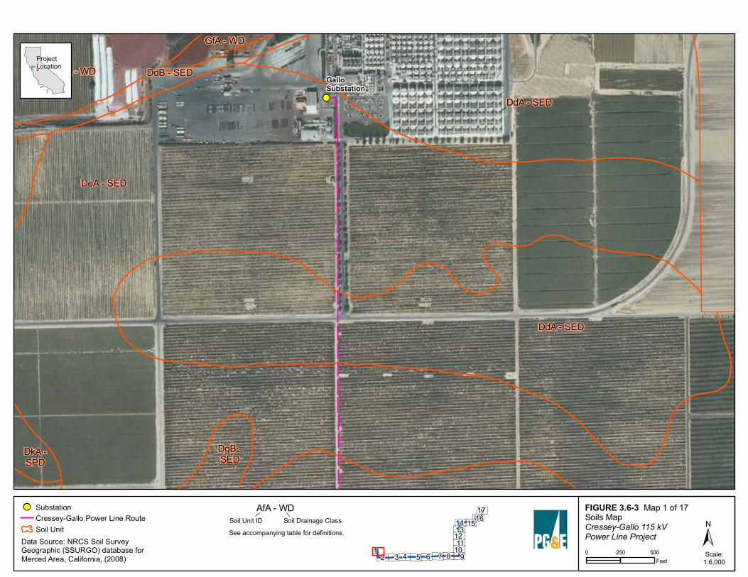
FIGURE 3.6-3Soils MapCressey-Gallo 115 kV Power Line Project ±
!!( SubstationCressey-Gallo Power Line RouteSoil Unit
Project Location
Scale:1:6,000R
Map 1 of 17AfA - WDSoil Unit ID Soil Drainage Class
See accompanying table for definitions.Data Source: NRCS Soil SurveyGeographic (SSURGO) database forMerced Area, California, (2008) 2 3 4 5 6 7 8
14 1617
19
1011
1213
15
0 250 500Feet

DdA - SED
DeA - SED
DdA - SED
HgA - SPD
DfA - SED
HoA - SPD
HgA - SPD
FIGURE 3.6-3Soils MapCressey-Gallo 115 kV Power Line Project ±
!!( SubstationCressey-Gallo Power Line RouteSoil Unit
Project Location
Scale:1:6,000R
Map 2 of 17AfA - WDSoil Unit ID Soil Drainage Class
See accompanying table for definitions.Data Source: NRCS Soil SurveyGeographic (SSURGO) database forMerced Area, California, (2008) 2 3 4 5 6 7 8
14 1617
19
1011
1213
15
0 250 500Feet

DdA - SED
DfA - SED
DdA - SED
DgA - SED
DcA - SED
DfB - SED
DoA - SPD
DcA -SED
DfB -SED DcA - SED
FIGURE 3.6-3Soils MapCressey-Gallo 115 kV Power Line Project ±
!!( SubstationCressey-Gallo Power Line RouteSoil Unit
Project Location
Scale:1:6,000R
Map 3 of 17AfA - WDSoil Unit ID Soil Drainage Class
See accompanying table for definitions.Data Source: NRCS Soil SurveyGeographic (SSURGO) database forMerced Area, California, (2008) 2 3 4 5 6 7 8
14 1617
19
1011
1213
15
0 250 500Feet

DfA - SEDDdA - SED
DfA - SED
DgA - SED
DgA - SED
DkA -SPD
DfB - SED
DkA -SPD
DcA -SEDDkA - SPD
DfA - SED
DkA - SPD
FIGURE 3.6-3Soils MapCressey-Gallo 115 kV Power Line Project ±
!!( SubstationCressey-Gallo Power Line RouteSoil Unit
Project Location
Scale:1:6,000R
Map 4 of 17AfA - WDSoil Unit ID Soil Drainage Class
See accompanying table for definitions.Data Source: NRCS Soil SurveyGeographic (SSURGO) database forMerced Area, California, (2008) 2 3 4 5 6 7 8
14 1617
19
1011
1213
15
0 250 500Feet
DfA - SED
DgA - SED
DgA - SED
DkA -SPD
DkA - SPDDkA - SPD
HgA - SPD
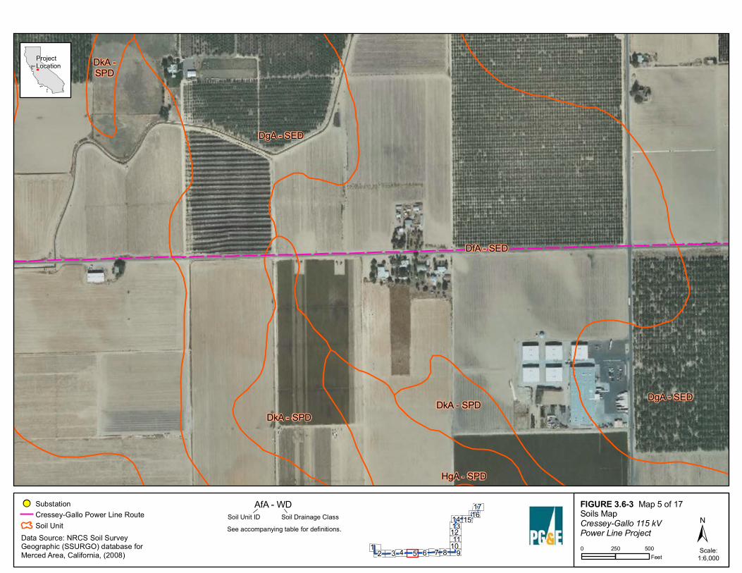
FIGURE 3.6-3Soils MapCressey-Gallo 115 kV Power Line Project ±
!!( SubstationCressey-Gallo Power Line RouteSoil Unit
Project Location
Scale:1:6,000R
Map 5 of 17AfA - WDSoil Unit ID Soil Drainage Class
See accompanying table for definitions.Data Source: NRCS Soil SurveyGeographic (SSURGO) database forMerced Area, California, (2008) 2 3 4 5 6 7 8
14 1617
19
1011
1213
15
0 250 500Feet

DfA - SED
DgA -SED
DgA - SED
DgA - SED
DkA -SPD
DmA- PD
DoA - SPDDkA - SPD
DgA - SED
DkA -SPD
FIGURE 3.6-3Soils MapCressey-Gallo 115 kV Power Line Project ±
!!( SubstationCressey-Gallo Power Line RouteSoil Unit
Project Location
Scale:1:6,000R
Map 6 of 17AfA - WDSoil Unit ID Soil Drainage Class
See accompanying table for definitions.Data Source: NRCS Soil SurveyGeographic (SSURGO) database forMerced Area, California, (2008) 2 3 4 5 6 7 8
14 1617
19
1011
1213
15
0 250 500Feet

DfA - SED
DcA - SED
DfA - SED
DgA - SED
DkA - SPD
AfA - WD
DeA - SED
DoA -SPD
DoA - SPD
DkA -SPD
DkA - SPD
FIGURE 3.6-3Soils MapCressey-Gallo 115 kV Power Line Project ±
!!( SubstationCressey-Gallo Power Line RouteSoil Unit
Project Location
Scale:1:6,000R
Map 7 of 17AfA - WDSoil Unit ID Soil Drainage Class
See accompanying table for definitions.Data Source: NRCS Soil SurveyGeographic (SSURGO) database forMerced Area, California, (2008) 2 3 4 5 6 7 8
14 1617
19
1011
1213
15
0 250 500Feet

DfA - SED
DcA - SED
AnA - WD
DfA - SED
DcA - SED
AnB - WD
DeA - SED
DfA - SED
AnA - WD
DeA - SED
FIGURE 3.6-3Soils MapCressey-Gallo 115 kV Power Line Project ±
!!( SubstationCressey - Gallo Power Line RouteSoil Unit
Project Location
Scale:1:6,000Rev. 5: 11/08/2011
Map 8 of 17AfA - WDSoil Unit ID Soil Drainage Class
See accompanying table for definitions.Data Source: NRCS Soil SurveyGeographic (SSURGO) database forMerced Area, California, (2008) 2 3 4 5 6 7 8
14 1617
19
1011
1213
15
0 250 500Feet

AnA - WD
DfA - SED
AnB - WD
AnB - WD
DfA - SED
AnA - WD
DcA - SED
FIGURE 3.6-3Soils MapCressey-Gallo 115 kV Power Line Project ±
!!( SubstationCressey-Gallo Power Line RouteSoil Unit
Project Location
Scale:1:6,000R
Map 9 of 17AfA - WDSoil Unit ID Soil Drainage Class
See accompanying table for definitions.Data Source: NRCS Soil SurveyGeographic (SSURGO) database forMerced Area, California, (2008) 2 3 4 5 6 7 8
14 1617
19
1011
1213
15
0 250 500Feet

AfA - WD
AnA - WD
SnA - WD
DfA - SED
FIGURE 3.6-3Soils MapCressey-Gallo 115 kV Power Line Project ±
!!( SubstationCressey-Gallo Power Line RouteSoil Unit
Project Location
Scale:1:6,000R
Map 10 of 17AfA - WDSoil Unit ID Soil Drainage Class
See accompanying table for definitions.Data Source: NRCS Soil SurveyGeographic (SSURGO) database forMerced Area, California, (2008) 2 3 4 5 6 7 8
14 1617
19
1011
1213
15
0 250 500Feet

DfA - SED
AfA - WD
AnA - WD
AnB - WD
SnA - WD
DfA - SED
FIGURE 3.6-3Soils MapCressey-Gallo 115 kV Power Line Project ±
!!( SubstationCressey-Gallo Power Line RouteSoil Unit
Project Location
Scale:1:6,000R
Map 11 of 17AfA - WDSoil Unit ID Soil Drainage Class
See accompanying table for definitions.Data Source: NRCS Soil SurveyGeographic (SSURGO) database forMerced Area, California, (2008) 2 3 4 5 6 7 8
14 1617
19
1011
1213
15
0 250 500Feet

DfA - SED
AfA - WD
AnA - WD
DeA - SED
AnA- WD
AnB - WD
FIGURE 3.6-3Soils MapCressey-Gallo 115 kV Power Line Project ±
!!( SubstationCressey-Gallo Power Line RouteSoil Unit
Project Location
Scale:1:6,000R
Map 12 of 17AfA - WDSoil Unit ID Soil Drainage Class
See accompanying table for definitions.Data Source: NRCS Soil SurveyGeographic (SSURGO) database forMerced Area, California, (2008) 2 3 4 5 6 7 8
14 1617
19
1011
1213
15
0 250 500Feet

DfA - SED
W - NA
AfA - WD
DfA - SED
DeA - SED
DeA - SEDDfA - SED
DeA - SED
DeA - SED
FIGURE 3.6-3Soils MapCressey-Gallo 115 kV Power Line Project ±
!!( SubstationCressey-Gallo Power Line RouteSoil Unit
Project Location
Scale:1:6,000R
Map 13 of 17AfA - WDSoil Unit ID Soil Drainage Class
See accompanying table for definitions.Data Source: NRCS Soil SurveyGeographic (SSURGO) database forMerced Area, California, (2008) 2 3 4 5 6 7 8
14 1617
19
1011
1213
15
0 250 500Feet

AgA - WD
AfA - WD
DfA -SED
AfA - WD
AgB - WD
DeA - SED
DfA - SEDW - NA
AfA - WDDfA -SEDDeA - SEDDeA -
SED
DeA - SED
FIGURE 3.6-3Soils MapCressey-Gallo 115 kV Power Line Project ±
!!( SubstationCressey-Gallo Power Line RouteSoil Unit
Project Location
Scale:1:6,000R
Map 14 of 17AfA - WDSoil Unit ID Soil Drainage Class
See accompanying table for definitions.Data Source: NRCS Soil SurveyGeographic (SSURGO) database forMerced Area, California, (2008) 2 3 4 5 6 7 8
14 1617
19
1011
1213
15
0 250 500Feet

AgA - WD
AfA - WD
AgB - WDAgB - WD
W - NA
AfA - WDAnA - WD
AnB - WD
FIGURE 3.6-3Soils MapCressey-Gallo 115 kV Power Line Project ±
!!( SubstationCressey-Gallo Power Line RouteSoil Unit
Project Location
Scale:1:6,000R
Map 15 of 17AfA - WDSoil Unit ID Soil Drainage Class
See accompanying table for definitions.Data Source: NRCS Soil SurveyGeographic (SSURGO) database forMerced Area, California, (2008) 2 3 4 5 6 7 8
14 1617
19
1011
1213
15
0 250 500Feet

AgA - WD
AkA - SPD
AfA - WD
AgB - WD
FIGURE 3.6-3Soils MapCressey-Gallo 115 kV Power Line Project ±
!!( SubstationCressey-Gallo Power Line RouteSoil Unit
Project Location
Scale:1:6,000R
Map 16 of 17AfA - WDSoil Unit ID Soil Drainage Class
See accompanying table for definitions.Data Source: NRCS Soil SurveyGeographic (SSURGO) database forMerced Area, California, (2008) 2 3 4 5 6 7 8
14 1617
19
1011
1213
15
0 250 500Feet

!!(
CresseySubstation
FdA - PD
Tg - NA
DpA - MWDGcA - SPD
DfA - SED
AfB - WD
AgA - WD
HeA - WD
FIGURE 3.6-3Soils MapCressey-Gallo 115 kV Power Line Project ±
!!( SubstationCressey-Gallo Power Line RouteSoil Unit
Project Location
Scale:1:6,000R
Map 17 of 17AfA - WDSoil Unit ID Soil Drainage Class
See accompanying table for definitions.Data Source: NRCS Soil SurveyGeographic (SSURGO) database forMerced Area, California, (2008) 2 3 4 5 6 7 8
14 1617
19
1011
1213
15
0 250 500Feet

!!(
!!(
Quien Sabe Fault
Project Location
Pacinies Fault
SANTACRUZ
COUNTY
MADERACOUNTY
MARIPOSA COUNTY
MERCED COUNTY
MONTEREYCOUNTY
SANBENITOCOUNTY
SAN JOAQUIN COUNTY
SANTA CLARA COUNTY
TUOLUMNE COUNTY
STANISLAUSCOUNTY
ALAMEDACOUNTY
CALAVERASCOUNTY
CONTRA COSTA COUNTY
FRESNOCOUNTYUV156
UV85
UV132
UV108
UV219
UV25
UV84
UV233
UV140
UV99
UV59
UV4
UV49
UV145
UV120
UV130
UV41
UV1
UV168
UV152
UV129
UV33
UV165
£¤101
Waterford
LathropManteca
Livermore
Tracy
Escalon
Ripon
Oakdale
Riverbank
Modesto
Ceres
Patterson
Turlock
Livingston
Newman
Atwater
MorganHill
Merced
Gilroy
Watsonville
LosBanos
Chowchilla
Madera
FirebaughClovis
DiscoveryBay
Gustine
Aromas
Salinas
§̈¦280
§̈¦5
§̈¦680
§̈¦205
§̈¦580
CresseySubstation
GalloSubstation
Ortigalita Fault
San Andreas Fault
Greenville Fault
Bear Mountains Fault
Calaveras
Fault
Sargent Fault
FIGURE 3.6-4Fault MapCressey-Gallo 115 kV Power Line Project ±
!!( SubstationCressey-GalloPower Line RouteFaults
InterstateU.S HighwayState HighwayUrban AreaCounty Boundary
Project Location
Scale:1:750,000R
0 5 10Miles
Data Source: Bryant, W. A. (compiler). 2005. Digital Database ofQuaternary and Younger Faults from the Fault Activity Map ofCalifronia, version 2.0. California Geological Survey.