Embed Size (px)
Citation preview
ARCTIC
VOL. 54, NO. 2 (JUNE 2001) P. 157– 161
Extending the Late Holocene White River Ash Distribution, Northwestern CanadaSTEPHEN D. ROBINSON1
(Received 30 May 2000; accepted in revised form 25 September 2000)
ABSTRACT. Peatlands are a particularly good medium for trapping and preserving tephra, as their surfaces are wet and wellvegetated. The extent of tephra-depositing events can often be greatly expanded through the observation of ash in peatlands. Thispaper uses the presence of the White River tephra layer (1200 B.P.) in peatlands to extend the known distribution of this lateHolocene tephra into the Mackenzie Valley, northwestern Canada. The ash has been noted almost to the western shore of GreatSlave Lake, over 1300 km from the source in southeastern Alaska. This new distribution covers approximately 540000 km2 witha tephra volume of 27 km3. The short time span and constrained timing of volcanic ash deposition, combined with unique physicaland chemical parameters, make tephra layers ideal for use as chronostratigraphic markers.
Key words: chronostratigraphy, Mackenzie Valley, peatlands, White River ash
RÉSUMÉ. Les tourbières constituent un milieu particulièrement approprié au piégeage et à la conservation de téphra, en raisonde l’humidité et de l’abondance de végétation qui règnent en surface. L’observation des cendres contenues dans les tourbièrespermet souvent d’élargir notablement les limites spatiales connues des épisodes de dépôts de téphra. Cet article recourt à laprésence de la couche de téphra de la rivière White (1200 BP) dans les tourbières pour agrandir la distribution connue de ce téphradatant de l’Holocène supérieur dans la vallée du Mackenzie, située dans le Nord-Ouest canadien. On a relevé la présence de cettecendre pratiquement jusqu’à la rive occidentale du Grand lac des Esclaves, à plus de 1300 km de son origine dans le sud-est del’Alaska. Cette nouvelle distribution couvre environ 540000 km2, avec un volume de téphra de 27 km3. Le fait que la cendrevolcanique se dépose relativement vite et en des moments précis, et qu’elle possède des paramètres physiques et chimiques bienparticuliers, rend les couches de téphra idéales pour servir de marqueurs chronostratigraphiques.
Mots clés: chronostratigraphie, vallée du Mackenzie, tourbières, cendre de la rivière White
Traduit pour la revue Arctic par Nésida Loyer.
1 Terrain Sciences Division, Geological Survey of Canada, 601 Booth St., Ottawa, Ontario K1A OE8, Canada; [email protected]© The Arctic Institute of North America
INTRODUCTION
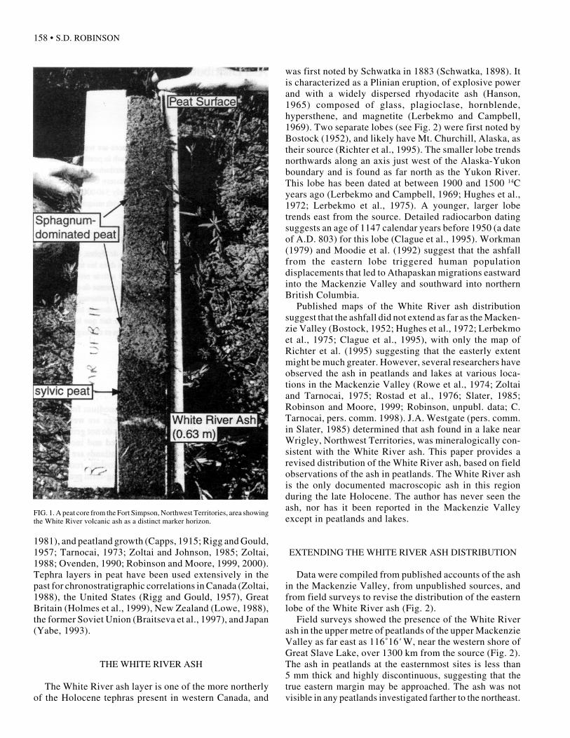
Tephra travels away from the source volcano in plumesdetermined by the prevailing wind direction at the time oferuption. Fine-grained tephra may travel hundreds of kilo-metres before being deposited. In distal environments,lake sediments and peat preserve tephra deposits only afew millimetres thick. Such thin deposits, which mayrepresent very powerful eruptions, are normally impossi-ble to trace with certainty in subaerial exposures becauseof post-depositional mixing and weathering processes.Thus, the known extent of tephra-depositing events canoften be greatly expanded through the observation of ashin peatlands (Lowe, 1988; Zoltai, 1988; Holmes et al.,1999). Tephra, or primary fallout debris, typically com-prises compact (and occasionally bedded) layers of vary-ing particle size, from fine macroscopic ash to mediumlapilli. These pale-coloured, unweathered layers are oftenvisible against darker lake sediments and peat (Fig. 1). Theshort span and constrained timing of volcanic ash deposi-tion, combined with unique physical and chemical param-eters, make tephra layers ideal for use as chronostratigraphicmarkers in lakes or peatlands (Robinson and Moore, 1999).
Peatlands are a particularly good medium for trappingand preserving tephra, as their surfaces are wet and wellvegetated. In distal areas, thin ashfalls do not generally killthe vegetation, and the ash is retained and incorporatedinto the peat as it grows vertically. Peatlands are generallynot subject to the same scale of erosion, rooting, andaeolian processes that may hamper long-term preservationin other environments. Peat-forming mosses grow fromtheir tips and have no roots, removing preservation prob-lems due to bioturbation that may be found in forests orareas with woody or herbaceous vegetation. Zoltai (1988)suggests that peat prevents the settling, or downwardtranslocation, of tephra. The downward percolation ofwater and runoff in upland soils also tends to preventpreservation where the tephra is thin.
Volcanic ash layers in western Canada have proved tobe very important chronostratigraphic markers in provid-ing age control for a variety of geomorphic processes,including alluvial fan growth (Ryder, 1971), slope proc-esses (Osborn and Luckman, 1981; Harris and McDermid,1998), fluvial aggradation and incision (Dawson, 1889;Fuller, 1986), glacier (Rampton, 1970) and rock glacierfluctuations (Dyke, 1990), lake level fluctuations (Clague,
158 • S.D. ROBINSON
1981), and peatland growth (Capps, 1915; Rigg and Gould,1957; Tarnocai, 1973; Zoltai and Johnson, 1985; Zoltai,1988; Ovenden, 1990; Robinson and Moore, 1999, 2000).Tephra layers in peat have been used extensively in thepast for chronostratigraphic correlations in Canada (Zoltai,1988), the United States (Rigg and Gould, 1957), GreatBritain (Holmes et al., 1999), New Zealand (Lowe, 1988),the former Soviet Union (Braitseva et al., 1997), and Japan(Yabe, 1993).
THE WHITE RIVER ASH
The White River ash layer is one of the more northerlyof the Holocene tephras present in western Canada, and
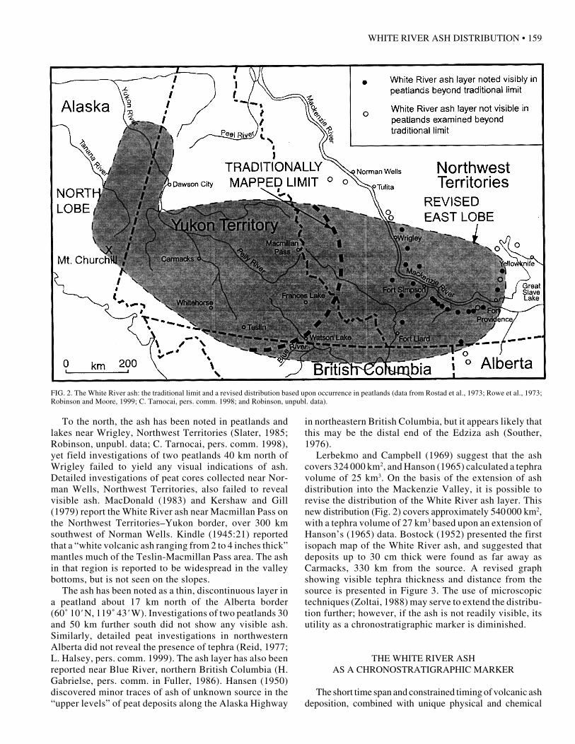
was first noted by Schwatka in 1883 (Schwatka, 1898). Itis characterized as a Plinian eruption, of explosive powerand with a widely dispersed rhyodacite ash (Hanson,1965) composed of glass, plagioclase, hornblende,hypersthene, and magnetite (Lerbekmo and Campbell,1969). Two separate lobes (see Fig. 2) were first noted byBostock (1952), and likely have Mt. Churchill, Alaska, astheir source (Richter et al., 1995). The smaller lobe trendsnorthwards along an axis just west of the Alaska-Yukonboundary and is found as far north as the Yukon River.This lobe has been dated at between 1900 and 1500 14Cyears ago (Lerbekmo and Campbell, 1969; Hughes et al.,1972; Lerbekmo et al., 1975). A younger, larger lobetrends east from the source. Detailed radiocarbon datingsuggests an age of 1147 calendar years before 1950 (a dateof A.D. 803) for this lobe (Clague et al., 1995). Workman(1979) and Moodie et al. (1992) suggest that the ashfallfrom the eastern lobe triggered human populationdisplacements that led to Athapaskan migrations eastwardinto the Mackenzie Valley and southward into northernBritish Columbia.
Published maps of the White River ash distributionsuggest that the ashfall did not extend as far as the Macken-zie Valley (Bostock, 1952; Hughes et al., 1972; Lerbekmoet al., 1975; Clague et al., 1995), with only the map ofRichter et al. (1995) suggesting that the easterly extentmight be much greater. However, several researchers haveobserved the ash in peatlands and lakes at various loca-tions in the Mackenzie Valley (Rowe et al., 1974; Zoltaiand Tarnocai, 1975; Rostad et al., 1976; Slater, 1985;Robinson and Moore, 1999; Robinson, unpubl. data; C.Tarnocai, pers. comm. 1998). J.A. Westgate (pers. comm.in Slater, 1985) determined that ash found in a lake nearWrigley, Northwest Territories, was mineralogically con-sistent with the White River ash. This paper provides arevised distribution of the White River ash, based on fieldobservations of the ash in peatlands. The White River ashis the only documented macroscopic ash in this regionduring the late Holocene. The author has never seen theash, nor has it been reported in the Mackenzie Valleyexcept in peatlands and lakes.
EXTENDING THE WHITE RIVER ASH DISTRIBUTION
Data were compiled from published accounts of the ashin the Mackenzie Valley, from unpublished sources, andfrom field surveys to revise the distribution of the easternlobe of the White River ash (Fig. 2).
Field surveys showed the presence of the White Riverash in the upper metre of peatlands of the upper MackenzieValley as far east as 116˚16' W, near the western shore ofGreat Slave Lake, over 1300 km from the source (Fig. 2).The ash in peatlands at the easternmost sites is less than5 mm thick and highly discontinuous, suggesting that thetrue eastern margin may be approached. The ash was notvisible in any peatlands investigated farther to the northeast.
FIG. 1. A peat core from the Fort Simpson, Northwest Territories, area showingthe White River volcanic ash as a distinct marker horizon.
WHITE RIVER ASH DISTRIBUTION • 159
To the north, the ash has been noted in peatlands andlakes near Wrigley, Northwest Territories (Slater, 1985;Robinson, unpubl. data; C. Tarnocai, pers. comm. 1998),yet field investigations of two peatlands 40 km north ofWrigley failed to yield any visual indications of ash.Detailed investigations of peat cores collected near Nor-man Wells, Northwest Territories, also failed to revealvisible ash. MacDonald (1983) and Kershaw and Gill(1979) report the White River ash near Macmillan Pass onthe Northwest Territories–Yukon border, over 300 kmsouthwest of Norman Wells. Kindle (1945:21) reportedthat a “white volcanic ash ranging from 2 to 4 inches thick”mantles much of the Teslin-Macmillan Pass area. The ashin that region is reported to be widespread in the valleybottoms, but is not seen on the slopes.
The ash has been noted as a thin, discontinuous layer ina peatland about 17 km north of the Alberta border(60˚ 10' N, 119˚ 43' W). Investigations of two peatlands 30and 50 km further south did not show any visible ash.Similarly, detailed peat investigations in northwesternAlberta did not reveal the presence of tephra (Reid, 1977;L. Halsey, pers. comm. 1999). The ash layer has also beenreported near Blue River, northern British Columbia (H.Gabrielse, pers. comm. in Fuller, 1986). Hansen (1950)discovered minor traces of ash of unknown source in the“upper levels” of peat deposits along the Alaska Highway
in northeastern British Columbia, but it appears likely thatthis may be the distal end of the Edziza ash (Souther,1976).
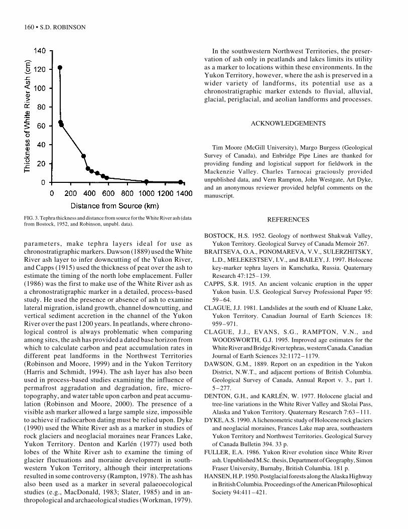
Lerbekmo and Campbell (1969) suggest that the ashcovers 324 000 km2, and Hanson (1965) calculated a tephravolume of 25 km3. On the basis of the extension of ashdistribution into the Mackenzie Valley, it is possible torevise the distribution of the White River ash layer. Thisnew distribution (Fig. 2) covers approximately 540000 km2,with a tephra volume of 27 km3 based upon an extension ofHanson’s (1965) data. Bostock (1952) presented the firstisopach map of the White River ash, and suggested thatdeposits up to 30 cm thick were found as far away asCarmacks, 330 km from the source. A revised graphshowing visible tephra thickness and distance from thesource is presented in Figure 3. The use of microscopictechniques (Zoltai, 1988) may serve to extend the distribu-tion further; however, if the ash is not readily visible, itsutility as a chronostratigraphic marker is diminished.
THE WHITE RIVER ASHAS A CHRONOSTRATIGRAPHIC MARKER
The short time span and constrained timing of volcanic ashdeposition, combined with unique physical and chemical
FIG. 2. The White River ash: the traditional limit and a revised distribution based upon occurrence in peatlands (data from Rostad et al., 1973; Rowe et al., 1973;Robinson and Moore, 1999; C. Tarnocai, pers. comm. 1998; and Robinson, unpubl. data).
160 • S.D. ROBINSON
parameters, make tephra layers ideal for use aschronostratigraphic markers. Dawson (1889) used the WhiteRiver ash layer to infer downcutting of the Yukon River,and Capps (1915) used the thickness of peat over the ash toestimate the timing of the north lobe emplacement. Fuller(1986) was the first to make use of the White River ash asa chronostratigraphic marker in a detailed, process-basedstudy. He used the presence or absence of ash to examinelateral migration, island growth, channel downcutting, andvertical sediment accretion in the channel of the YukonRiver over the past 1200 years. In peatlands, where chrono-logical control is always problematic when comparingamong sites, the ash has provided a dated base horizon fromwhich to calculate carbon and peat accumulation rates indifferent peat landforms in the Northwest Territories(Robinson and Moore, 1999) and in the Yukon Territory(Harris and Schmidt, 1994). The ash layer has also beenused in process-based studies examining the influence ofpermafrost aggradation and degradation, fire, micro-topography, and water table upon carbon and peat accumu-lation (Robinson and Moore, 2000). The presence of avisible ash marker allowed a large sample size, impossibleto achieve if radiocarbon dating must be relied upon. Dyke(1990) used the White River ash as a marker in studies ofrock glaciers and neoglacial moraines near Frances Lake,Yukon Territory. Denton and Karlén (1977) used bothlobes of the White River ash to examine the timing ofglacier fluctuations and moraine development in south-western Yukon Territory, although their interpretationsresulted in some controversy (Rampton, 1978). The ash hasalso been used as a marker in several palaeoecologicalstudies (e.g., MacDonald, 1983; Slater, 1985) and in an-thropological and archaeological studies (Workman, 1979).
In the southwestern Northwest Territories, the preser-vation of ash only in peatlands and lakes limits its utilityas a marker to locations within these environments. In theYukon Territory, however, where the ash is preserved in awider variety of landforms, its potential use as achronostratigraphic marker extends to fluvial, alluvial,glacial, periglacial, and aeolian landforms and processes.
ACKNOWLEDGEMENTS
Tim Moore (McGill University), Margo Burgess (GeologicalSurvey of Canada), and Enbridge Pipe Lines are thanked forproviding funding and logistical support for fieldwork in theMackenzie Valley. Charles Tarnocai graciously providedunpublished data, and Vern Rampton, John Westgate, Art Dyke,and an anonymous reviewer provided helpful comments on themanuscript.
REFERENCES
BOSTOCK, H.S. 1952. Geology of northwest Shakwak Valley,Yukon Territory. Geological Survey of Canada Memoir 267.
BRAITSEVA, O.A., PONOMAREVA, V.V., SULERZHITSKY,L.D., MELEKESTSEV, I.V., and BAILEY, J. 1997. Holocenekey-marker tephra layers in Kamchatka, Russia. QuaternaryResearch 47:125– 139.
CAPPS, S.R. 1915. An ancient volcanic eruption in the upperYukon basin. U.S. Geological Survey Professional Paper 95:59 –64.
CLAGUE, J.J. 1981. Landslides at the south end of Kluane Lake,Yukon Territory. Canadian Journal of Earth Sciences 18:959 –971.
CLAGUE, J.J., EVANS, S.G., RAMPTON, V.N., andWOODSWORTH, G.J. 1995. Improved age estimates for theWhite River and Bridge River tephras, western Canada. CanadianJournal of Earth Sciences 32:1172 –1179.
DAWSON, G.M., 1889. Report on an expedition in the YukonDistrict, N.W.T., and adjacent portions of British Columbia.Geological Survey of Canada, Annual Report v. 3., part 1.5 –277.
DENTON, G.H., and KARLÉN, W. 1977. Holocene glacial andtree-line variations in the White River Valley and Skolai Pass,Alaska and Yukon Territory. Quaternary Research 7:63 –111.
DYKE, A.S. 1990. A lichenometric study of Holocene rock glaciersand neoglacial moraines, Frances Lake map area, southeasternYukon Territory and Northwest Territories. Geological Surveyof Canada Bulletin 394. 33 p.
FULLER, E.A. 1986. Yukon River evolution since White Riverash. Unpublished M.Sc. thesis, Department of Geography, SimonFraser University, Burnaby, British Columbia. 181 p.
HANSEN, H.P. 1950. Postglacial forests along the Alaska Highwayin British Columbia. Proceedings of the American PhilosophicalSociety 94:411 –421.
FIG. 3. Tephra thickness and distance from source for the White River ash (datafrom Bostock, 1952, and Robinson, unpubl. data).
WHITE RIVER ASH DISTRIBUTION • 161
HANSON, L.W. 1965. Size distribution of the White River ash,Yukon Territory. Unpublished M.Sc. thesis, Department ofGeology, University of Alberta, Edmonton. 59 p.
HARRIS, S.A., and McDERMID, G. 1998. Frequency of debrisflows on the Sheep Mountain fan, Kluane Lake, Yukon Territory.Zeitschrift für Geomorphologie 42:159 –175.
HARRIS, S.A., and SCHMIDT, I. H. 1994. Permafrost aggradationand peat accumulation since 1200 years B.P. in peat plateaus atTuchitua, Yukon Territory (Canada). Journal of Paleolimnology12:3 – 17.
HOLMES, J., HALL, V., and WILSON, P. 1999. Volcanoes andpeat bogs. Geology Today 15(2):60 –63.
HUGHES, O.L., RAMPTON, V.N., and RUTTER, N.W. 1972.Quaternary geology and geomorphology, southern and centralYukon. 24th International Geological Congress, Montreal,Guidebook A-11. 59 p.
KERSHAW, G.P., and GILL, D. 1979. Growth and decay of palsasand peat plateaus in the Macmillan Pass–Tsichu River area,Northwest Territories, Canada. Canadian Journal of EarthSciences 16:1362 –1374.
KINDLE, E.D. 1945. Geological reconnaissance along the CanolRoad, from Teslin River to Macmillan Pass, Yukon. GeologicalSurvey of Canada Paper 45-21. 26 p.
LERBEKMO, J.F., and CAMPBELL, F.A. 1969. Distribution,composition, and source of the White River ash, Yukon Territory.Canadian Journal of Earth Sciences 6:109 –116.
LERBEKMO, J.F., WESTGATE, J.A., SMITH, D.G.W., andDENTON, G.H. 1975. New data on the character and history ofthe White River volcanic eruption, Alaska. In: Suggate, R.P.,and Cresswell, M.M., eds. Quaternary Studies. Wellington: TheRoyal Society of New Zealand. 203 –209.
LOWE, D.J. 1988. Late Quaternary volcanism in New Zealand:Towards an integrated record using distal airfall tephras in lakesand bogs. Journal of Quaternary Science 3:111 –120.
MacDONALD, G.M. 1983. Holocene vegetation history of theupper Natla River area, Northwest Territories, Canada. Arcticand Alpine Research 15:169 –180.
MOODIE, D.W., CATCHPOLE, A.J.W., and ABEL, K. 1992.Northern Athapaskan oral traditions and the White River volcano.Ethnohistory 39:148 – 171.
OSBORN, G., and LUCKMAN, B.H. 1981. Origin of an unusualHolocene diamicton in Banff National Park, Alberta, Canada.Zeitschrift für Geomorphologie 25:290 –299.
OVENDEN, L. 1990. Peat accumulation in northern wetlands.Quaternary Research 33:377 –386.
RAMPTON, V.N. 1970. Neoglacial fluctuations of the Natazhatand Klutlan Glaciers, Yukon Territory, Canada. Canadian Journalof Earth Sciences 7:1236 –1263.
——. 1978. Holocene glacial and tree-line variations in the WhiteRiver Valley and Skolai Pass, Alaska and Yukon Territory: Adiscussion. Quaternary Research 10:130 –134.
REID, D.E. 1977. Permafrost in peat landforms in northwesternAlberta. In: Vegetation surveys and disturbance studies alongthe proposed Arctic Gas Route. Biological Report Series, Volume37. Calgary, Alberta: Arctic Gas.
RICHTER, D.H., PREECE, S.J., McGIMSEY, R.G., andWESTGATE, J.A. 1995. Mount Churchill, Alaska: The sourceof the late Holocene White River ash. Canadian Journal of EarthSciences 32:741 –748.
RIGG, G.B., and GOULD, H.R. 1957. Age of Glacier Peak eruptionand chronology of post-glacial peat deposits in Washington andsurrounding areas. American Journal of Science 255:341 –363.
ROBINSON, S.D., and MOORE, T.R. 1999. Carbon and peataccumulation over the past 1200 years in a landscape withdiscontinuous permafrost, northwestern Canada. GlobalBiogeochemical Cycles 13:591 – 601.
———. 2000. The influence of permafrost and fire upon carbonaccumulation in High Boreal peatlands, Northwest Territories,Canada. Arctic, Antarctic, and Alpine Research 32:155 – 166.
ROSTAD, H.P.W., WHITE, R.A., and ACTON, D.F. 1976. Soilsurvey and land evaluation of the Liard and Mackenzie Riverarea, Northwest Territories. Saskatchewan Institute of PedologyPublication S173. Saskatoon: University of Saskatchewan.285 p.
ROWE, J.S., BERGSTEINSSON, G.A., PADBURY, G.A., andHERMISH, R. 1974. Fire studies in the Mackenzie Valley.Arctic Land Use Research Program (ALUR) Report 1973 –74.Ottawa: Department of Indian Affairs and Northern Development.123 p.
RYDER, J.M. 1971. The stratigraphy and morphology of para-glacial alluvial fans in south-central British Columbia. CanadianJournal of Earth Sciences 8:279 –298.
SCHWATKA, F., 1889. Along Alaska’s great river. Chicago,Illinois: G.M. Hill Publishers.
SLATER, D.S. 1985. Pollen analysis of postglacial sediments fromEildun Lake, District of Mackenzie, N.W.T., Canada. CanadianJournal of Earth Sciences 22:663 –674.
SOUTHER, J.G. 1976. Geothermal power: The Canadian potential.Geoscience Canada 3:14 –20.
TARNOCAI, C. 1973. Soils of the Mackenzie River area.Environmental-Social Committee, Northern Pipelines. TaskForce on Northern Oil Development. Report 73-26. Ottawa:Information Canada. 136 p.
WORKMAN, W.B. 1979. The significance of volcanism in theprehistory of subarctic North America. In: Sheets, P.D., andGrayson, D.K., eds. Volcanic activity and human ecology. NewYork: Academic Press. 339 –371.
YABE, K. 1993. Wetlands of Hokkaido. In: Higashi, S., Osawa, A.,and Kanagawa, K., eds. Biodiversity and ecology in thenorthernmost Japan. Sapporo, Japan: University of HokkaidoPress. 38 –49.
ZOLTAI, S.C. 1988. Late Quaternary volcanic ash in the peatlandsof central Alberta. Canadian Journal of Earth Sciences 26:207 –214.
ZOLTAI, S.C., and JOHNSON, J.D. 1985. Development of a treedbog island in a minerotrophic fen. Canadian Journal of Botany63:1076 – 1085.
ZOLTAI, S.C., and TARNOCAI, C. 1975. Perennially frozenpeatlands in the western Arctic and Subarctic of Canada. CanadianJournal of Earth Sciences 12:28 –43.