Embed Size (px)
Citation preview

6Exploring Greater Manchester
ExploringGreater Manchester
a fieldwork guide
Web edition edited by Paul Hindle
Original printed edition (1998) edited by Ann Gardiner,Paul Hindle, John McKendrick and Chris Perkins

1Exploring Greater Manchester
Salford Quays
C. M. Lawformerly of Salford University
Aim: to explore the structure and character of these regenerated docklands.Starting point: Salford Quays Metrolink Station.Estimated time spent on site: One hour plus any time spent in the Lowry and the Imperial War Museum of the North.Further reading:Law, C. M. (1988) The Redevelopment of Manchester Docks, University of Salford, Department of Geography, Discussion Paper No 33.Law, C. M. (1988) From Manchester Docks to Salford Quays, Manchester Geographer, NS 9, 2-15. Myerson, J. (2000) Making the Lowry, Salford, Lowry Press. White, K.N., Bellinger, E.G., Saul, A.J., Hendry, K. and Bristow, M.R. (1993) Urban Waterside Regeneration: Problems and Prospects, Chichester,
Ellis Harwood. (several chapters deal with Salford Quays)
Most of the larger developments mentioned have websites and there is also one for Salford Quays.Date of last revision: March 2012 by Paul Hindle.
IntroductionThe Manchester Ship Canal, which follows closely the Rivers Mersey and Irwell, was opened throughout in 1894. The main docks were built beside the Trafford Road in Salford, and later in 1905 the large No 9 Dock was opened. Manchester businessmen had argued for the building of the canal because they believed that the Liverpool docks were overcharging. However, upon the opening of the canal, Liverpool charges were reduced and trade on the canal grew slowly. To encourage trade, the world’s first industrial estate was planned in 1896 at Trafford Park on the south bank, which was linked to the docks by a private railway. For many decades the Manchester Docks handled about 2M tons of cargo a year and at their peak employed about 3,500 workers. In the 1960s and 1970s, with the containerisation of trade, its concentration in a few other British ports and the increase in the size of ships, trade at the docks almost completely disappeared between 1972 and 1982 leaving behind redundant space.
In 1981 parts of the dock estate, particularly the undeveloped northern areas, were designated an Enterprise Zone (EZ) to last for 10 years and hopefully attract new activities. The nature of the EZ incentives meant that it attracted either light industry found in the north or offices found in the designated part of the docklands. By 1981-3 it was realised that trade in the docks was likely to disappear completely and that large funds would be required to transform the docks for other uses. The Manchester Ship Canal, at this time thinking that there would not be a return on any investment, sold the docks to Salford City
Council so that public funding could be obtained. Plans were drawn up and the new name of Salford Quays given. In 1985 the government agreed to provide £30M for the basic infrastructure part of the scheme, with other funding coming from the City Council, and the European Union. A condition of this funding was that all development should be privately financed, and to that end the southern part of the docks was sold to Urban Waterside. The plan proposed that the land should be used for residential, employment and leisure purposes in approximately equal amounts. Unlike many other dockland redevelopment schemes in Britain, with the exception of the Dock Offices, no buildings have been preserved or were thought worthy of preservation.
Redevelopment commenced in 1986 and gathered momentum in the late 1980s. The economic boom and the prospect of the ending of EZ status in 1991 stimulated construction, particularly of offices. However by 1991 when many of the offices were just being completed, there was a recession and many remained unoccupied for many years and development overall was stalled. In the late 1990s as the economy picked up, development resumed. Lottery funding enabled the construction of `The Lowry` arts centre. There have been more dwellings constructed and the Metrolink extension through the area to Eccles was opened in late 1999. Office take-up has increased, reducing vacancies and encouraging developers to contemplate new construction. In 2007 the BBC agreed to relocate activities to a site north of the Lowry Centre and form the core of a Media City which will complete the redevelopment of the docks. Salford Quays is generally regarded as a successful

2Exploring Greater Manchester
example of regeneration, creating jobs, housing and leisure facilities, but these have been mainly for middle class people coming from outside the area. One issue concerns the extent to which the scheme has benefited and will benefit local people. Another aspect of the lack of integration is reflected in the need for a high level of security.
The Trail described below starts by the two blue cranes at the eastern end of the Ontario Basin, just north of the Salford Quays Metrolink station, However those arriving by car may start at any other point on the trail; cars can be parked in the Lowry Outlet Centre. At various point along the route there are maps of Salford Quays.
15
14
13
12
11
10
9
8
7
6
5
4
3
21
SwingBridge
Metrolink
AnchorageStation
VictoriaBuilding
Harbour CityStation
BroadwayStation
MediaCityUKStation
SalfordQuaysStation
The LowryFootbridge
ImperialWar Museumof the Nor th
DetroitBridge
TheAnchorage
DesignerOutlet
The Pie Factory
TheLowry
CopthorneHotel
QuayWest
Manchester UnitedFootball Ground
MANCHESTER
SH IP CANAL
BRIDGEWATER CANAL
Trafford Wharf
East W
harf N
East W
harf S
THE QUAYS
TR
AF
FO
RD
RO
AD
WATERFRONT QUAY
MERCHANTS QUAY
CLIPPERS QUAY
NorthBay
SouthBay
CentralBay
HuronBasin
ErieBasin
OntarioBasin
St.FrancisBasin
St.LouisBasin
St.PeterBasin
0 200 m
N
3Exploring Greater Manchester
1. The Ontario Basin is one of the former docks which is now cut off from the canal and entered by a lock at the western end. It is connected by canals to the other basins.
The central 116,000 sq. ft. Victoria Building was completed in 1992 in the midst of a recession. A second office building, The Alexandra with 61,000 sq. ft. of space was completed in 2002. The area between the Anchorage and these blocks has now been occupied by the Millennium Tower with over 200 apartments. Next is @mediacity occupied largely by Bupa. On the other side of the Victoria Building are the City Lofts.
2. Walk along the side of Ontario Basin past the Premier Inn, a budget hotel with 52 rooms opened in 1996 and the Quay House Beefeater restaurant opened in 1990, both owned by Whitbread. Turn right to walk along Mariners Canal.
3. Across the canal is Grain Wharf. This estate of houses and apartments was built between 1985 and 1995. Salford Quays attracts many non-family households of one or two persons; many are rented, perhaps as an interim measure. Others may belong to persons who need to be in Manchester to work only for a few days in the week and have another house elsewhere. The prices of the properties and the social composition of the residents contrast with those in the Ordsall district of Salford on the other side of the Trafford Road, a typical inner city district with much public housing and many lower income residents.
4. On reaching Erie Basin turn right and pass Anchorage Quay; a development of 80 dwellings completed in 1998. Proceed to the large office block at the head of the dock called The Anchorage; it was the first large office block to be constructed in the Quays. Completed in 1991 with a floor space of 275,000 sq. ft.; its main tenant is BUPA the private health insurance company which employs over 500 people.
5. Pier 9 on the north side of the Erie Basin remains in the ownership of the Manchester Ship Canal Company (Peel Holdings). In the late 1980s it planned a large office complex along the entire length of the quay to be called Harbour City.
Ontario Basin at the start of the Trail.
Victoria Building: site 5.
6. Turn left to cross Dock 9 over Detroit Bridge, a former railway bridge that was relocated here. This dock is used for events such as regattas. Turn right along the side of the Huron Basin towards the Lowry Outlet Centre and The Lowry. Look across the basin to where Media City is. Over £400 million was invested in this site by the developers Peel Holdings, and the North West Development Agency is contributing £40 million. In 2011 the BBC moved 2400 jobs here, from Manchester and London. This 200 acre complex will attract other media firms to the site and create over 15,000 jobs in all. There is also a new Metrolink station.
Detroit Bridge: site 6.

4Exploring Greater Manchester
Media City. The last piece of Salford Quays to be developed is the £650m 36 acre Media City UK due for completion in 2013. The BBC is moving activities from London and Manchester to create 2400 jobs. Among the departments that are based here are BBC Sport and BBC Radio 5 Live. ITV is to move all its Manchester activities from its base in Quay Street including the Coronation Street studios and will employ 500 staff. Several other media firms are moving here including Satellite Information Services (SIS). The University of Salford is moving its media departments here and 1500 students will be based in the Quays. In addition there will be a new 218 bed room hotel, 378 apartments and office accommodation. Information about the development (including a map) is given on the MediaCityUK website (www.mediacityuk.co.uk).
7. The Lowry Outlet Mall is an £70M complex of cinemas, shops, restaurants bars and a 172 apartment block, opened in 2001. The Lowry itself was designed by Michael Wilford and was opened in April 2000; the £98M centre, assisted by £64M of lottery funding, contains two theatres, the Lowry art collection and other exhibition space. A third component of this end of the pier development is the Digital World Centre.
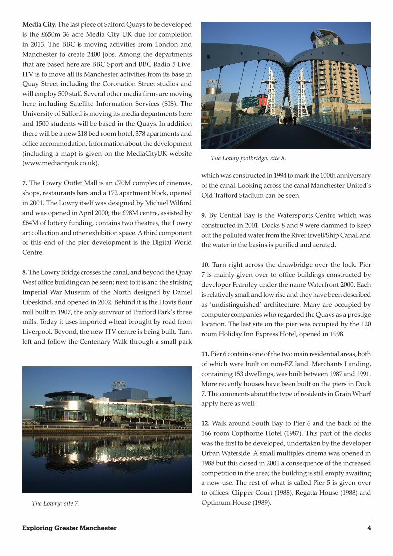
8. The Lowry Bridge crosses the canal, and beyond the Quay West office building can be seen; next to it is and the striking Imperial War Museum of the North designed by Daniel Libeskind, and opened in 2002. Behind it is the Hovis flour mill built in 1907, the only survivor of Trafford Park’s three mills. Today it uses imported wheat brought by road from Liverpool. Beyond, the new ITV centre is being built. Turn left and follow the Centenary Walk through a small park
which was constructed in 1994 to mark the 100th anniversary of the canal. Looking across the canal Manchester United’s Old Trafford Stadium can be seen.
9. By Central Bay is the Watersports Centre which was constructed in 2001. Docks 8 and 9 were dammed to keep out the polluted water from the River Irwell/Ship Canal, and the water in the basins is purified and aerated.
10. Turn right across the drawbridge over the lock. Pier 7 is mainly given over to office buildings constructed by developer Fearnley under the name Waterfront 2000. Each is relatively small and low rise and they have been described as ‘undistinguished’ architecture. Many are occupied by computer companies who regarded the Quays as a prestige location. The last site on the pier was occupied by the 120 room Holiday Inn Express Hotel, opened in 1998.
11. Pier 6 contains one of the two main residential areas, both of which were built on non-EZ land. Merchants Landing, containing 153 dwellings, was built between 1987 and 1991. More recently houses have been built on the piers in Dock 7. The comments about the type of residents in Grain Wharf apply here as well.
12. Walk around South Bay to Pier 6 and the back of the 166 room Copthorne Hotel (1987). This part of the docks was the first to be developed, undertaken by the developer Urban Waterside. A small multiplex cinema was opened in 1988 but this closed in 2001 a consequence of the increased competition in the area; the building is still empty awaiting a new use. The rest of what is called Pier 5 is given over to offices: Clipper Court (1988), Regatta House (1988) and Optimum House (1989). The Lowry: site 7.
The Lowry footbridge: site 8.

5Exploring Greater Manchester
13. On the other side of Trafford Road is the large Exchange Quay (530,000 sq. ft.) one of three such large office buildings constructed around 1991 and which contrast with the earlier smaller scale office blocks. Along the road more office blocks have recently been built including the Metro-Exchange Quay with 72,000 sq. ft. of space. The Etap and Ramada hotels have 345 bedrooms. Behind them Lowry Homes has built 262 apartments
14. The island site beside Trafford Road is owned by Urban Waterside (see above). Originally there were plans for a large building here, but the recession of the early 1990s prevented such proposals from being realised and in its place four low density eateries were opened in 1996. The accessibility of
the Quays and thereby its attractiveness for development has been enhanced by various road improvement schemes in the area including the improvement of Trafford Road to a dual carriageway in 1997.
15. The Dock Office was built in 1926. Behind the Dock Office is the tall Furness House built in 1969 for use by Furness Withy who ran Manchester Liners, then an important shipping line associated with the port. In front of the Dock Office is Ontario House, built in 1990 and let to a government department. The value of such offices has increased since the Metrolink line (Manchester to Eccles) which passes in front of them was opened in 2000, improving accessibility.