Embed Size (px)
Citation preview

Estimation of Rangeland Changes & Evapotranspiration Using
Multispectral Thermal Infrared Data
Andy French1, Tom Schmugge2, Juan Manuel Sanchez3, Enric Valor4, Cesar Coll4
1 U.S. Arid Land Agricultural Research Center, USDA/ARS, Maricopa, Arizona2 Physical Sciences, New Mexico State University
3 University of Albacete4 University of Valencia

Acknowledgements
Al RangoKris Havstad
Jornada Experimental Range, USDA/ARS

Outline
•Rangeland cover change using thermal infrared with ASTER & MASTER•Effect of remote sensing resolution over Jornada•Modeling surface energy fluxes using land surface temperatures and emissivities•Objective: Highlight HyspIRI’s multispectral TIR capability for rangeland science

From: Jeffrey E Herrick, Veronica C Lessard, Kenneth E Spaeth, Patrick L Shaver, Robert S Dayton, David A Pyke, Leonard Jolley, and J Jeffery Goebel. 2010. National ecosystem assessments supported by scientific and local knowledge. Frontiers in Ecology and the Environment 8: 403–408. "Copyright by the Ecological Society of America"
Mapping Rangeland Degradation

50 km
ASTER Composite over Jornada2001-2003

Dynamic Range of Remotely Sensed Vegetation Indices over Rangeland is small

Thermal Band Emissivities Could Help Monitor Vegetation Cover Regardless of Greenness
Siliceous Soil Split-Window Region

Spectral Variation of Brightness Temperature•Strong soil signature•Affected by surface moisture•Vegetation masking of soil
10 11 12
13 14

Emissivityλ=8.2µm
MASTER
HyspIRI ASTER
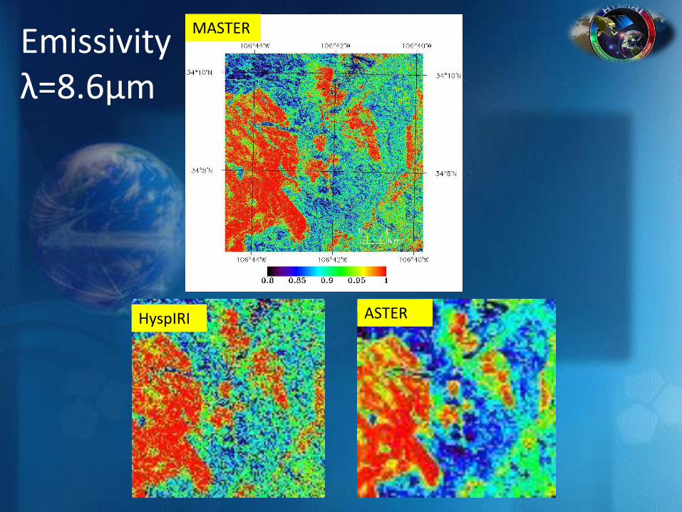
Emissivityλ=8.6µm
MASTER
HyspIRI ASTER

Emissivityλ=9.1µm
MASTER
HyspIRI ASTER
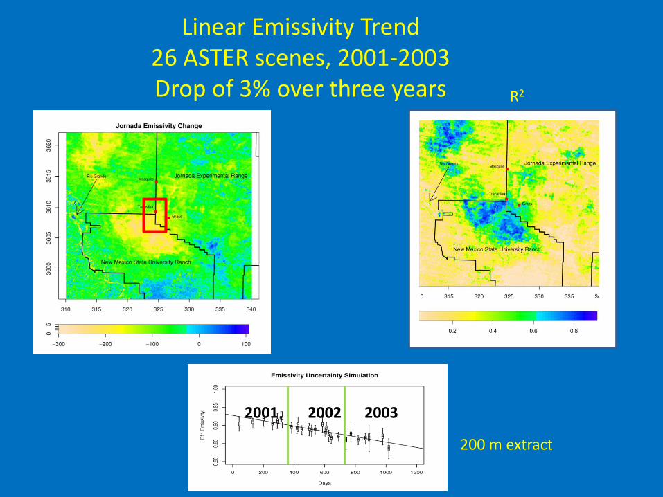
Linear Emissivity Trend26 ASTER scenes, 2001-2003Drop of 3% over three years
2001 2002 2003
R2
200 m extract
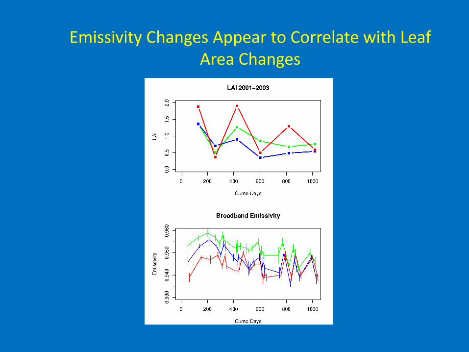
Emissivity Changes Appear to Correlate with Leaf Area Changes

Land Surface Temperature Validation of ASTER at Jornada, 2002
MODIS/Terra
ASTER
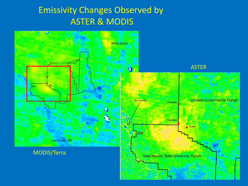
Emissivity Changes Observed byASTER & MODIS

Multispectral TIR constrains atmospheric correction terms
Transmissivity
Up
wel
ling
Rad
ian
ce
1. Atmospheric profile at site uncertain2. Errors in correction will exaggerate spectral
emissivity contrasts3. Can constrain errors:
1. Check LSTs after correction.2. Adjust atmospheric correction
parameters using ‘known’ emissivity targets.
LST Estimation
Error

Short Wavelength Emissivities with ASTER/MODISJornada 2003

MASTER Band 43 Emissivity Changes May 2001/2002/2003
May 2001 May 2002 May 2003
6-12 m resolution

6 m 12 m
48 m 60 m
24 m
120 m
Land Surface Temperature Scaling over Jornada Rangeland
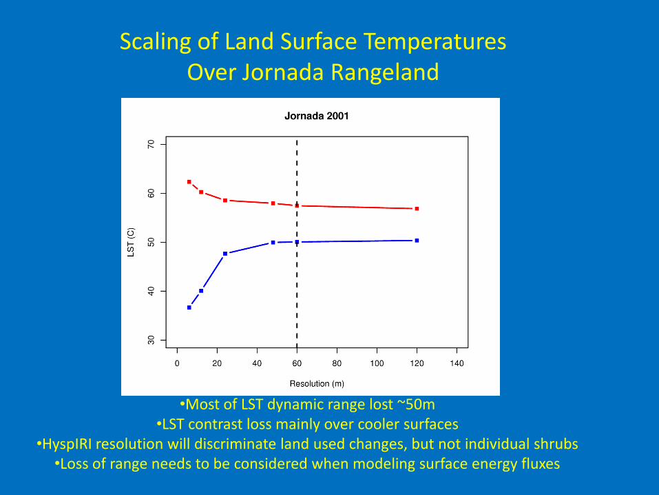
Scaling of Land Surface Temperatures Over Jornada Rangeland
•Most of LST dynamic range lost ~50m•LST contrast loss mainly over cooler surfaces
•HyspIRI resolution will discriminate land used changes, but not individual shrubs•Loss of range needs to be considered when modeling surface energy fluxes

NDVI is not a satisfactory estimator for Emissivity

Land Surface Emissivity:Seasonal Variability
Examples from Rangeland & Cropland
B29 Emissivity vs. NDVIEmissivity responds
to harvest not senescence

Surface Energy Balance Modeling:Incorporation of Emissivity Observations
Rn – G = H + LERn: reassign soil fraction to senescent vegetation fraction, revise light extinction, revise emissivities for canopy & soilG: affected by Rn_soil reductionH: Increases importance of aerodynamic resistance term raLE: Affected by changes in Rn, G, H
Penman (no TIR & no stress detection)
Priestley-Taylor
Evaporation (soil, residual)

Emissivities Can Improve Net Radiation Estimation

ET Modeling with ASTER & MASTERat Jornada 2001-2003
Rangeland LE is small, but not zeroModeling with MASTER will help answer what can be resolved at 60 m
Rangeland
Irrigated Lands
Precipitation

Conclusions
•Multispectral thermal infrared provides new information about rangeland vegetation cover•This information can be used to improve discrimination of senescent vegetation & modeling of surface energy fluxes•MASTER 6-12 m results show impact of resolution on observations over rangeland, modeling will help answer consequence for water flux estimation.========================================•Implication for HyspIRI: Regional to Global scale data products should include time-continuous multispectral emissivities for detecting weekly-yearly+ changes.


Emissivities May Help Disaggregation (‘Sharpening’)
.)1( 1010 EmisscckNDVIbbkLST

Comparing Sensor Emissivities:MODIS B29 vs. ASTER B11