Embed Size (px)
Citation preview
1
Enabling and Emerging Technologies for SocialDistancing: A Comprehensive Survey and Open
ProblemsCong T. Nguyen1, Yuris Mulya Saputra1, Nguyen Van Huynh1, Ngoc-Tan Nguyen1, Tran Viet Khoa1,
Bui Minh Tuan1, Diep N. Nguyen1, Dinh Thai Hoang1, Thang X. Vu2, Eryk Dutkiewicz1, Symeon Chatzinotas2,and Bjorn Ottersten2
1 School of Electrical and Data Engineering, University of Technology Sydney, Australia2 Interdisciplinary Centre for Security, Reliability and Trust, University of Luxembourg, Luxembourg
Abstract—Social distancing plays a pivotal role in preventingthe spread of viral diseases illnesses such as COVID-19. Byminimizing the close physical contact among people, we canreduce the chances of catching the virus and spreading it acrossthe community. This paper aims to provide a comprehensivesurvey on how emerging technologies, e.g., wireless and network-ing, artificial intelligence (AI) can enable, encourage, and evenenforce social distancing practice. To that end, we first providea comprehensive background of social distancing including basicconcepts, measurements, models, and propose various practicalsocial distancing scenarios. We then discuss enabling wirelesstechnologies which are especially effective and can be widelyadopted in practice to keep distance, encourage, and enforcesocial distancing in general. After that, other emerging andrelated technologies such as machine learning, computer vision,thermal, ultrasound, etc., are introduced. These technologies openmany new solutions and directions to deal with problems in socialdistancing, e.g., symptom prediction, detection and monitoringquarantined people, and contact tracing. Finally, we provideimportant open issues and challenges (e.g., privacy-preserving,scheduling, and incentive mechanisms) in implementing socialdistancing in practice. As an example, instead of reacting withad-hoc responses to COVID-19-like pandemics in the future,smart infrastructures (e.g., next-generation wireless systems like6G, smart home/building, smart city, intelligent transportationsystems) should incorporate a pandemic mode in its standardarchitecture/design.
Index Terms—Social distancing, pandemic, COVID-19, tech-nologies, wireless, networking, positioning systems, AI, machinelearning, data analytics, localization, privacy-preserving, schedul-ing, and incentive mechanism.
I. INTRODUCTION
COVID-19 has completely changed the world’s view onpandemics with dire consequences to global health and econ-omy. Within only four months (from January to April 2020),210 countries and territories around the world have reportedmore than three million infected people including more thantwo hundred thousand deaths [1]. Besides the global healthcrisis, COVID-19 has also been causing massive economiclosses (e.g., a possible 25% unemployment rate in the U.S. [2],
IEEE Copyright Notice: This paper was accepted and published by IEEEAccess. The published versions of this article are: “A Comprehensive Surveyof Enabling and Emerging Technologies for Social DistancingPart I: Funda-mentals and Enabling Technologies” DOI: 10.1109/ACCESS.2020.3018140and “A Comprehensive Survey of Enabling and Emerging Technologies forSocial DistancingPart I: Fundamentals and Enabling Technologies” DOI:10.1109/ACCESS.2020.3018140.
one million people lost their jobs in Canada during March2020 [3], 1.4 million jobs lost in Australia [4], and a projectedglobal 3% GDP loss [5]), resulting in a global recession aspredicted by many experts [5]–[7]. In such context, there isan urgent need for solutions to contain the disease spread,thereby reducing its negative impacts and buying more timefor pharmaceutical solution development.
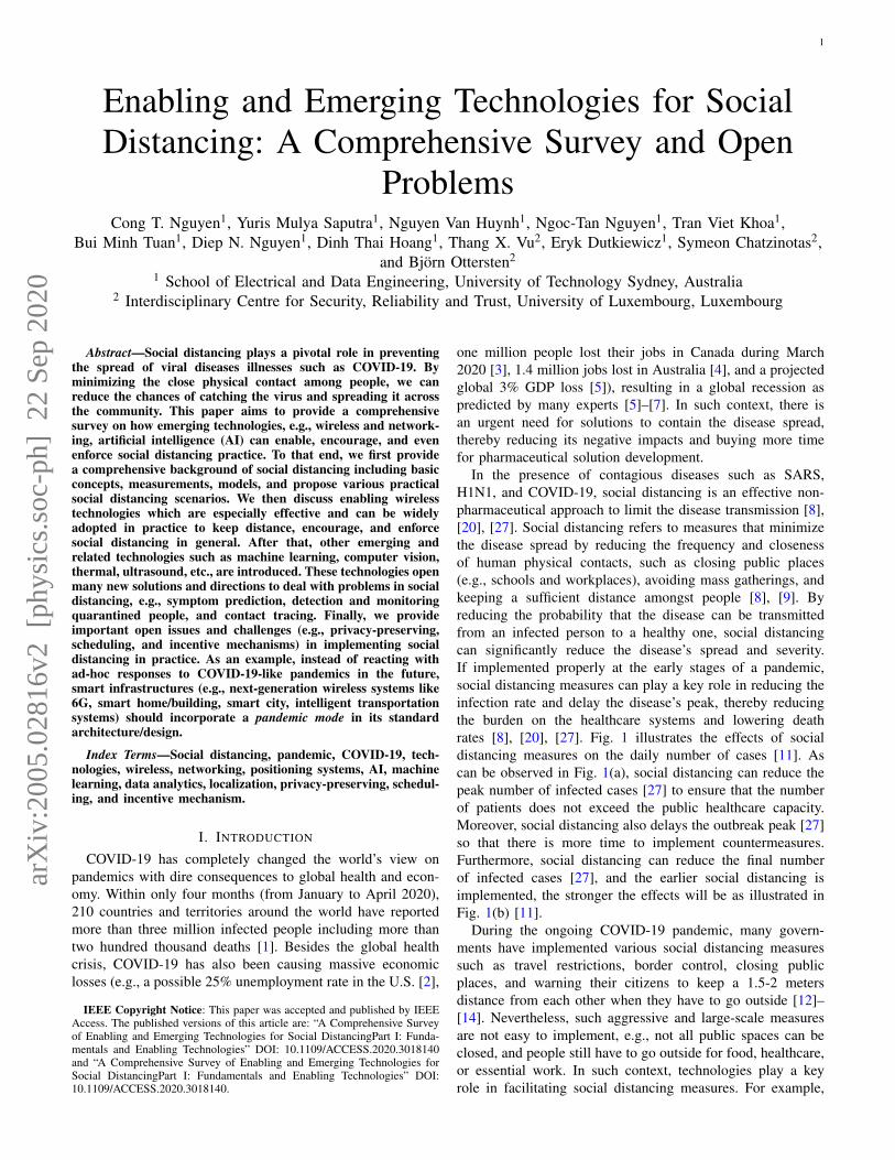
In the presence of contagious diseases such as SARS,H1N1, and COVID-19, social distancing is an effective non-pharmaceutical approach to limit the disease transmission [8],[20], [27]. Social distancing refers to measures that minimizethe disease spread by reducing the frequency and closenessof human physical contacts, such as closing public places(e.g., schools and workplaces), avoiding mass gatherings, andkeeping a sufficient distance amongst people [8], [9]. Byreducing the probability that the disease can be transmittedfrom an infected person to a healthy one, social distancingcan significantly reduce the disease’s spread and severity.If implemented properly at the early stages of a pandemic,social distancing measures can play a key role in reducing theinfection rate and delay the disease’s peak, thereby reducingthe burden on the healthcare systems and lowering deathrates [8], [20], [27]. Fig. 1 illustrates the effects of socialdistancing measures on the daily number of cases [11]. Ascan be observed in Fig. 1(a), social distancing can reduce thepeak number of infected cases [27] to ensure that the numberof patients does not exceed the public healthcare capacity.Moreover, social distancing also delays the outbreak peak [27]so that there is more time to implement countermeasures.Furthermore, social distancing can reduce the final numberof infected cases [27], and the earlier social distancing isimplemented, the stronger the effects will be as illustrated inFig. 1(b) [11].
During the ongoing COVID-19 pandemic, many govern-ments have implemented various social distancing measuressuch as travel restrictions, border control, closing publicplaces, and warning their citizens to keep a 1.5-2 metersdistance from each other when they have to go outside [12]–[14]. Nevertheless, such aggressive and large-scale measuresare not easy to implement, e.g., not all public spaces can beclosed, and people still have to go outside for food, healthcare,or essential work. In such context, technologies play a keyrole in facilitating social distancing measures. For example,
arX
iv:2
005.
0281
6v2
[ph
ysic
s.so
c-ph
] 2
2 Se
p 20
20
2
(a)
Daily number
of cases
Delay outbreak peak
Reduce outbreak
peak
Heath care system capacity
Cumulative cases
70,000
60,000
50,000
40,000
30,000
20,000
10,000
Number of days
(b)
5 10 15 20 25 30
No social distancing
Social distancing implemented 1 day later (n+21)
40 % more cases
Social distancing implemented on
day n+20
Cases without protective measures
Cases with protective measures
Time since first case
Fig. 1: Effects of social distancing [11].
wireless positioning systems can effectively help people tokeep a safe distance by measuring the distances among peopleand alerting them when they are too close to each other.Moreover, other technologies such as Artificial Intelligence(AI) technologies can be used to facilitate or even enforcesocial distancing.
In this article, we present a comprehensive survey onenabling and emerging technologies for social distancing. Themain aims are to provide a comprehensive background onsocial distancing as well as effective technologies that can beused to facilitate the social distancing practice. In particular,we first present basic concepts of social distancing togetherwith its measurements, models, effectiveness, and practicalscenarios. After that, we review enabling wireless technologieswhich are especially effective in monitoring and keepingdistance amongst people. Then, we discuss various emergingtechnologies, e.g., AI, thermal, computer vision, ultrasound,and visible light, which have been introduced recently in orderto address many new issues related to social distancing, e.g.,contact tracing, quarantined people detection and monitoring,and symptom prediction. Finally, some important open issuesand challenges (e.g., privacy-preserving, scheduling, and in-centive mechanisms) of implementing technologies for socialdistancing will be discussed. Furthermore, potential solutionstogether with future research directions are also highlightedand addressed.
Although there are few surveys related to localizationand positioning systems, e.g., [15]–[18], to the best of ourknowledge, this is the first survey in the literature discussing
technologies for social distancing. It is worth noting that, dueto the increasingly complex development of many types ofviruses as well as the rapid growth of social interaction andglobalization, the concept of social distancing is not as simpleas physical distancing. In fact, it also includes many non-pharmaceutical interventions or measures taken to prevent thespread of contagious diseases, such as monitoring, detection,and warning people (as we identify and propose in Table I).Thanks to the significant development of emerging technolo-gies, e.g., future wireless systems, AI, and data analytics, manynew solutions have been introduced recently which can createfavorable conditions for practicing social distancing.
As illustrated in Fig. 2, the rest of this paper is organized asfollows. We first provide a brief overview of social distancingand distance measurement methods in Section II. Then, Sec-tion III and Section IV discuss enabling wireless technolo-gies and other emerging technologies for social distancing,respectively. After that, we discuss open issues and futureresearch directions of technology-enabled social distancing inSection V, and conclusions are given in Section VI.
II. SOCIAL DISTANCING: A FUNDAMENTAL BACKGROUND
A. Social Distancing
1) Definition and Classifications: Social distancing refersto the non-pharmaceutical measures to reduce the frequencyof physical contacts and the contact distances between peopleduring an infectious disease outbreak [10]. Social distancingmethods can be classified into public and individual measures.Public measures include closing or reducing access to educa-tional institutions and workplaces, canceling mass gatherings,travel restrictions, border control, and quarantining buildings.Individual measures consist of isolation, quarantine, and en-couragement to keep physical distances between people [9].Although these measures can cause some negative impacts onthe economy and individual freedom, they play a crucial rolein reducing the severity of a pandemic [10].
2) Measurements and Models: The evaluation of socialdistancing measures is often based on several standardizedapproaches. One of the main criteria for social distancingmeasures selection is the basic reproduction number Ro whichrepresents on average how many people a case (i.e., an infec-tious person) will infect during its entire infectious period [19].For example, Ro < 1 indicates that every case will infectfewer than 1 person, and thus the disease is declining inthe considered population. Since the value of Ro representshow quickly the disease is spreading, Ro has been one ofthe most important indicators for social distancing measuresselection [20], [27]. Mathematically, Ro can be determined by
Ro =
∫ ∞
0b(a)F(a)da, (1)
where b(a) is the average number of new cases an infectiousperson will infect per unit of time during the infectious perioda, and F(a) is the probability that the individual will remaininfectious during the period a [19].
Beside showing the transmissibility of a disease, Ro alsogives some intuitive ideas on how to limit the disease spread.
3
III. WirelessTechnologies
for Social Distancing
IV. OtherEmerging
Technologies for Social
Distancing
IV. OtherEmerging
Technologies for Social
Distancing
A. Wi-Fi B. Cellular C. BluetoothD. Ultra-
widebandE. GNSS F. Zigbee G. RFID
V. Open Issues and Future Research Directions
II. SocialDistancing: A Fundamental Background
Enabling and Emerging
Technologies for Social
Distancing
A. SocialDistancing
B. PositioningTechnologies
A. Computer Vision
B. Ultrasound
C. InertialSensors
D. VisibleLights
E. Thermal
A. Security and Privacy-Preserving in Social Distancing
B. Real-timeScheduling
and Optimization
C. IncentiveMechanism to
Encourage Social Distancing
D. Pandemic Modefor Social
Distancing Implementation
F. ArtificialIntelligence
Fig. 2: The organization of this survey.
As observed from (1), Ro can be reduced in different ways,i.e., to decrease b(a) or F(a). To reduce b(a), there areseveral approaches such as to lower the number of contactsthe infected individuals make per unit of time (e.g., avoidmass gatherings and public places closures) or to reduce theprobability that a contact will infect a new person (e.g., bywearing masks). To reduce F(a), the infected person needs tobe cured or completely avoid contacts with the non-infected(e.g., isolation and quarantine).
3) Effectiveness: To evaluate the effectiveness of socialdistancing, a common approach is to measure the attack ratewhich is the percentage of infected people in a susceptiblepopulation (where no one is immune at the beginning of thedisease) at the time of measurement [22]. The attack ratereflects the severity of a disease at a given time, and thus ithas different values during the disease outbreak. Among thesevalues, the peak attack rate is often considered and comparedto the current healthcare capacity (e.g., intensive care unitcapacity) to see the current system’s ability to handle the peaknumber of patients. After the outbreak is over, data is oftencollected to determine the final attack rate which is the totalnumber of infected cases over the entire course of the outbreakdivided by the total population.
Social distancing measures are proven to be effective whenimplemented properly [22]–[28]. Different types of socialdistancing measures may have diverse levels of effectivenesson the disease spread. In [22], the effect of social distancingmeasures at workplaces is evaluated by an agent-based simula-tion approach. In particular, six different workplace strategiesthat reduce the number of workdays are simulated. The resultsshow that, for a seasonal influenza (Ro = 1.4), reducing thenumber of workdays can effectively reduce the final attack rate(e.g., up to 82% if three consecutive workdays are reduced).Nevertheless, in a pandemic-level influenza (Ro = 2.0), reduc-ing the number of workdays has a significantly weaker impact,i.e., 3% (one extra day off) to 21% decrease (three extraconsecutive days off). Several other studies present similarresults. In [23], it is shown that workplace social distancingcan reduce the final attack rate by up to 39% in a Ro = 1.4
setting. Similarly, [24] shows that different types of measurescan reduce the attack rate from 11% to 20% depending on thefrequency of contacts among the employees.
For school closure measures, studies also show positiveeffects. In [25], a modeling technique is employed to examinethe effects of four different social distancing measures underthree varying Ro settings. Among different types of measures,the school closure measure is shown to be able to reduce thefinal attack rate by 20%, 10%, and 5%, and the peak attackrate by 77%, 47%, and 32% in the cases where Ro < 1.9,2.0 ≤ R0 ≤ 2.4, and Ro > 2.5, respectively. Similarly, it isshown in [26] that prolonged school closure in a pandemiccontext can reduce the final attack rate by up to 17% and thepeak attack rate by up to 45%.
Another common social distancing measure is the isolationof the infected cases and cases with similar symptoms. In [27],large-scale epidemic simulations are performed to evaluatedifferent strategies for influenza pandemic mitigation. Amongthe simulated strategies, the results show that the properimplementation (such that an isolated individual reduces 90%of its contact rate) of isolation can reduce the final attack rateby 7% in a Ro = 2 setting. Similarly, it is shown in [25] thatisolation can reduce the final attack rate by 27%, 7%, and 5%,and the peak attack rate by 89%, 72%, and 53% in the caseswhere Ro < 1.9, 2.0 ≤ R0 ≤ 2.4, and Ro > 2.5, respectively.
For household quarantines, studies have shown that thismeasure can be effective if the compliance level is sufficient.In [27], the effects of voluntary quarantine of household fora duration of 14 days are examined. Simulations are carriedout with the assumption that 50% of households will comply,which leads to a 75% reduction of external contact rates, whilethe internal contact rate will increase by 100%. The resultsshow that this measure can reduce the final attack rate by upto 6% and the peak attack rate by up to 40%. Similarly, in [28],simulations are performed to examine the impacts of differentmeasures. For household quarantines, the result shows that thismeasure can reduce the final attack rate by 31% and the peakattack rate by 68% with Ro = 1.8 and a compliance rate of50%.
4
Apart from the abovementioned measures, the effectivenessof the other social distancing measures either received limitedattention or was often considered in combination with anotherapproach. In [27], the effectiveness of travel restrictions andborder control measures are examined. However, the resultsonly show that different levels of travel restrictions (from90% to 99.9%) can delay the peak attack rate by up to sixweeks, while how travel restrictions affect the attack rate isnot examined. Another type of measure that does not receivemuch attention is community contact reduction measures (e.g.,avoid crowds and mass gatherings cancellation). In [25], it isshown that this type of measure can reduce the final attackrate by 17%, 14%, and 10%, and the peak attack rate by 72%,49%, and 38% in the cases where Ro < 1.9, 2.0 ≤ Ro ≤ 2.4,and Ro > 2.5, respectively.
When combined together, social distancing measures areproven to be even more effective [25], [27], [29]. It is shownin [25] that when all four measures, i.e., school closure,isolation, workplace nonattendance, and community contactreduction, are in effect, they can drastically reduce the attackrates in all the considered Ro settings. In particular, the finalattack rate can decrease from 65% to only 3% and the peakattack rate from 474 cases per 10 thousand to only five cases,in the highest Ro setting. Similarly, [27] examines the effectswhen household quarantines, workplace closures, border con-trol, and travel restrictions are combined. The results showthat the final and peak attack rates are three times and sixtimes, respectively, lower than when no policy is implemented.Moreover, the peak attack rate can be delayed by nearly threemonths in a Ro = 1.7 setting. In [29], it is also shown thatwhen four types of measures (i.e., school closure, householdquarantines, workplace nonattendance, and community contactreduction) are in effect, the final attack rate can be reduced3-4 times depending on Ro.
There are several studies focusing on the negative impactsof social distancing. In [30], simulations are performed toevaluate the benefit and cost of different social distancingstrategies. In this study, simulations are carried out without andwith social distancing under different caution levels settings.Simulation results are evaluated based on the benefits of thereduced infection rate and the economic cost of reducingcontacts. The main finding of this work is that a favorableresult can only be obtained by implementing social distancingmeasures with a high caution level. Since the economiccost is also considered, it is shown that implementing socialdistancing with an insufficient caution level gives worse resultsthan that of the case without social distancing. In [31], agame theoretical approach based on the classic SIR model isproposed to evaluate the benefits and costs of social distancingmeasures. Interestingly, the results show that in the case whereRo < 1, the equilibrium behaviors include no social distancingmeasures. Moreover, social distancing measures are shown toachieve the highest economic benefit when Ro ≈ 2.
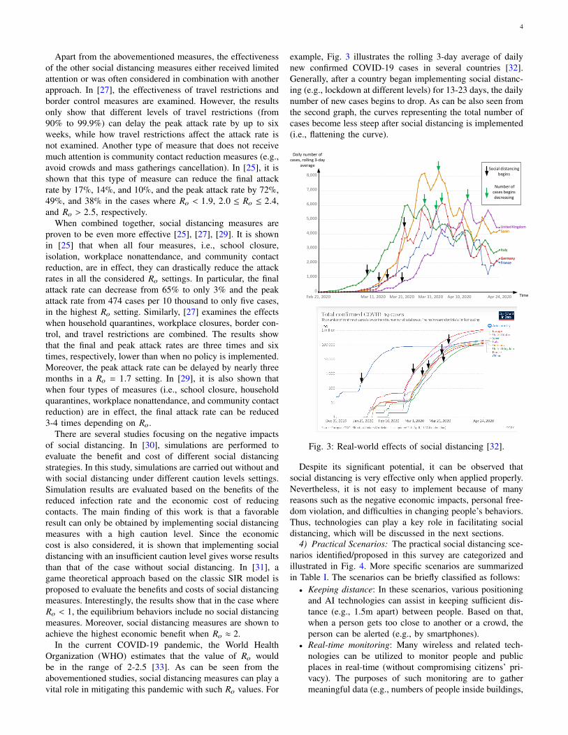
In the current COVID-19 pandemic, the World HealthOrganization (WHO) estimates that the value of Ro wouldbe in the range of 2-2.5 [33]. As can be seen from theabovementioned studies, social distancing measures can play avital role in mitigating this pandemic with such Ro values. For
example, Fig. 3 illustrates the rolling 3-day average of dailynew confirmed COVID-19 cases in several countries [32].Generally, after a country began implementing social distanc-ing (e.g., lockdown at different levels) for 13-23 days, the dailynumber of new cases begins to drop. As can be also seen fromthe second graph, the curves representing the total number ofcases become less steep after social distancing is implemented(i.e., flattening the curve).
Feb 21, 2020 Mar 11, 2020 Mar 21, 2020 Mar 31, 2020 Apr 10, 2020 Apr 24, 2020
0
1,000
2,000
3,000
4,000
5,000
6,000
7,000
8,000
United KingdomUnited KingdomSpainSpain
ItalyItaly
GermanyGermanyFranceFrance
Social distancing begins
Number of cases begins decreasing
Daily number of cases, rolling 3-day
average
Time
Fig. 3: Real-world effects of social distancing [32].
Despite its significant potential, it can be observed thatsocial distancing is very effective only when applied properly.Nevertheless, it is not easy to implement because of manyreasons such as the negative economic impacts, personal free-dom violation, and difficulties in changing people’s behaviors.Thus, technologies can play a key role in facilitating socialdistancing, which will be discussed in the next sections.
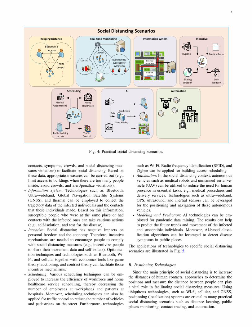
4) Practical Scenarios: The practical social distancing sce-narios identified/proposed in this survey are categorized andillustrated in Fig. 4. More specific scenarios are summarizedin Table I. The scenarios can be briefly classified as follows:• Keeping distance: In these scenarios, various positioning
and AI technologies can assist in keeping sufficient dis-tance (e.g., 1.5m apart) between people. Based on that,when a person gets too close to another or a crowd, theperson can be alerted (e.g., by smartphones).
• Real-time monitoring: Many wireless and related tech-nologies can be utilized to monitor people and publicplaces in real-time (without compromising citizens’ pri-vacy). The purposes of such monitoring are to gathermeaningful data (e.g., numbers of people inside buildings,
5
Social Distancing Scenarios
Keeping Distance
Between 2 persons
From crowd
Real-time Monitoring
contacts
Crowd
quarantined/ susceptible/ symptoms
Real-time Monitoring
contacts
Crowd
quarantined/ susceptible/ symptoms
Information system
Infected movement
Contact tracing
Infected movement
Contact tracing
Incentive
Medical Form
Sharing Location
Self-isolation
Hygiene
Scheduling AI Automation
Medical Appointment
Home Healthcare
Public building access
Traffic Control
Data Mining
DataPrediction
Scheduling AI Automation
Medical Appointment
Home Healthcare
Public building access
Traffic Control
Data Mining
DataPrediction
Fig. 4: Practical social distancing scenarios.
contacts, symptoms, crowds, and social distancing mea-sures violations) to facilitate social distancing. Based onthese data, appropriate measures can be carried out (e.g.,limit access to buildings when there are too many peopleinside, avoid crowds, and alert/penalize violations).
• Information system: Technologies such as Bluetooth,Ultra-wideband, Global Navigation Satellite Systems(GNSS), and thermal can be employed to collect thetrajectory data of the infected individuals and the contactsthat these individuals made. Based on this information,susceptible people who were at the same place or hadcontacts with the infected ones can take cautious actions(e.g., self-isolation, and test for the disease).
• Incentive: Social distancing has negative impacts onpersonal freedom and the economy. Therefore, incentivemechanisms are needed to encourage people to complywith social distancing measures (e.g., incentivize peopleto share their movement data and self-isolate). Optimiza-tion techniques and technologies such as Bluetooth, Wi-Fi, and cellular together with economics tools like gametheory, auctioning, and contract theory can facilitate thoseincentive mechanisms.
• Scheduling: Various scheduling techniques can be em-ployed to increase the efficiency of workforce and homehealthcare service scheduling, thereby decreasing thenumber of employees at workplaces and patients athospitals. Moreover, scheduling techniques can also beapplied for traffic control to reduce the number of vehiclesand pedestrians on the street. Furthermore, technologies
such as Wi-Fi, Radio frequency identification (RFID), andZigbee can be applied for building access scheduling.
• Automation: In the social distancing context, autonomousvehicles such as medical robots and unmanned aerial ve-hicle (UAV) can be utilized to reduce the need for humanpresence in essential tasks, e.g., medical procedures anddelivery services. Technologies such as ultra-wideband,GPS, ultrasound, and inertial sensors can be leveragedfor the positioning and navigation of these autonomousvehicles.
• Modeling and Prediction: AI technologies can be em-ployed for pandemic data mining. The results can helpto predict the future trends and movement of the infectedand susceptible individuals. Moreover, AI-based classi-fication algorithms can be leveraged to detect diseasesymptoms in public places.
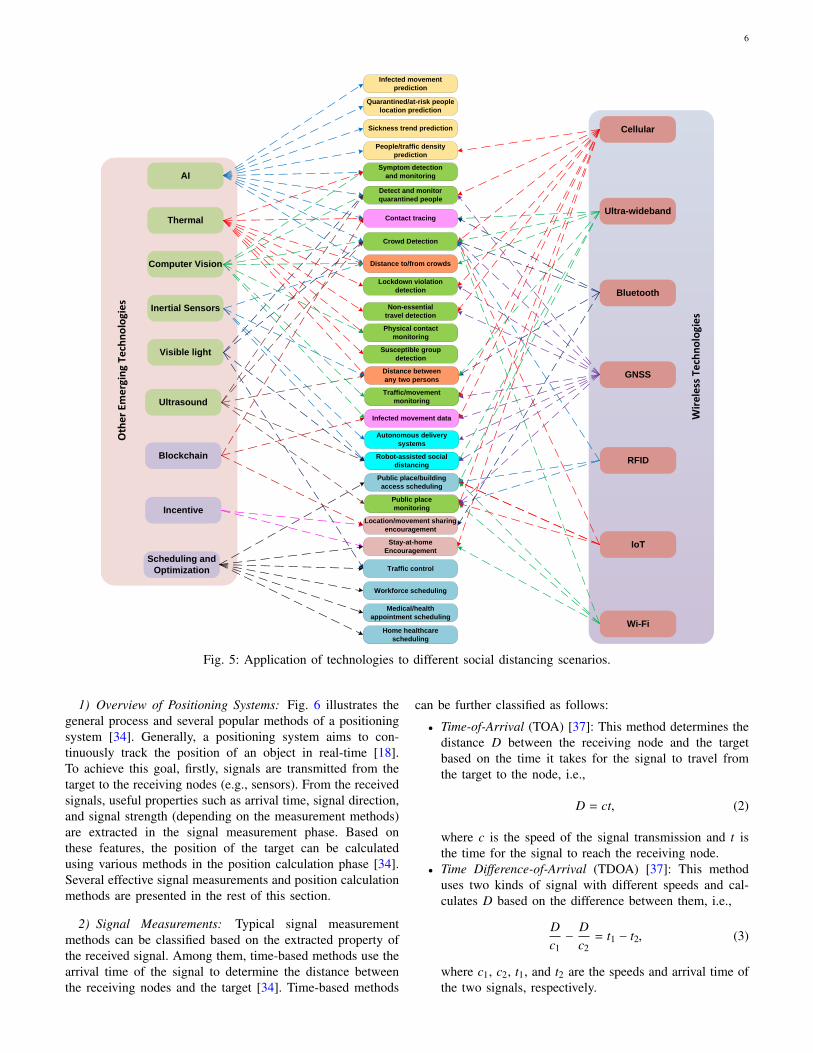
The applications of technologies to specific social distancingscenarios are illustrated in Fig. 5.
B. Positioning Technologies
Since the main principle of social distancing is to increasethe distances of human contacts, approaches to determine thepositions and measure the distance between people can playa vital role in facilitating social distancing measures. Usingubiquitous technologies, such as Wi-fi, cellular, and GNSS,positioning (localization) systems are crucial to many practicalsocial distancing scenarios such as distance keeping, publicplaces monitoring, contact tracing, and automation.
6
AI
Computer Vision
Ultrasound
Inertial Sensors
Visible light
Thermal
Scheduling and
Optimization
Blockchain
Oth
er
Emer
gin
g Te
chn
olo
gie
s
Incentive
AI
Computer Vision
Ultrasound
Inertial Sensors
Visible light
Thermal
Scheduling and
Optimization
Blockchain
Oth
er
Emer
gin
g Te
chn
olo
gie
s
Incentive
Wi-Fi
Cellular
Bluetooth
Ultra-wideband
IoT
RFID
GNSSDistance between
any two persons
Distance to/from crowds
Crowd Detection
Home healthcare
scheduling
Workforce scheduling
Medical/health
appointment scheduling
Robot-assisted social
distancing
Symptom detection
and monitoring
Traffic/movement
monitoring
Public place
monitoring
Infected movement data
Stay-at-home
Encouragement
Public place/building
access scheduling
Traffic control
Lockdown violation
detection
Non-essential
travel detection
Susceptible group
detection
Contact tracing
Sickness trend prediction
People/traffic density
prediction
Quarantined/at-risk people
location prediction
Physical contact
monitoring
Detect and monitor
quarantined people
Location/movement sharing
encouragement
Infected movement
prediction
Autonomous delivery
systems
Wir
eles
s Te
chn
olo
gie
s
Fig. 5: Application of technologies to different social distancing scenarios.
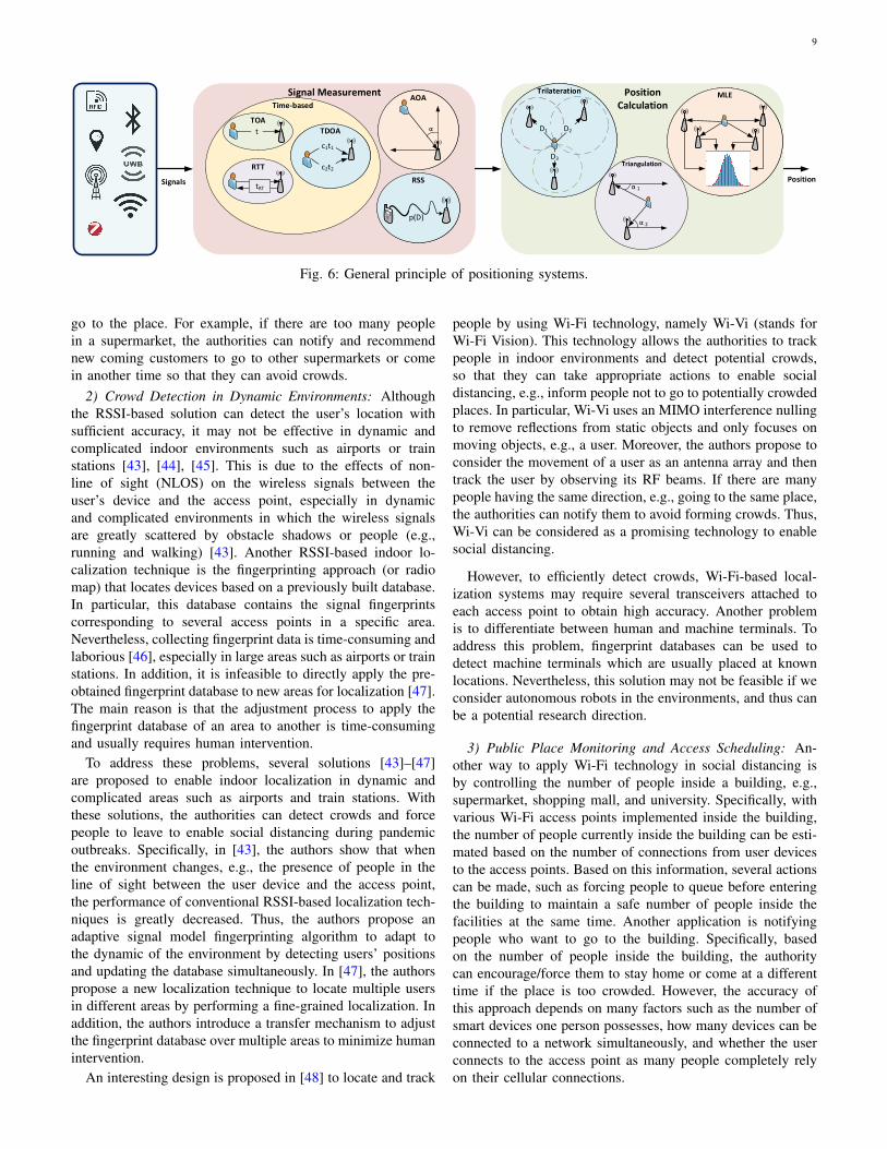
1) Overview of Positioning Systems: Fig. 6 illustrates thegeneral process and several popular methods of a positioningsystem [34]. Generally, a positioning system aims to con-tinuously track the position of an object in real-time [18].To achieve this goal, firstly, signals are transmitted from thetarget to the receiving nodes (e.g., sensors). From the receivedsignals, useful properties such as arrival time, signal direction,and signal strength (depending on the measurement methods)are extracted in the signal measurement phase. Based onthese features, the position of the target can be calculatedusing various methods in the position calculation phase [34].Several effective signal measurements and position calculationmethods are presented in the rest of this section.
2) Signal Measurements: Typical signal measurementmethods can be classified based on the extracted property ofthe received signal. Among them, time-based methods use thearrival time of the signal to determine the distance betweenthe receiving nodes and the target [34]. Time-based methods
can be further classified as follows:
• Time-of-Arrival (TOA) [37]: This method determines thedistance D between the receiving node and the targetbased on the time it takes for the signal to travel fromthe target to the node, i.e.,
D = ct, (2)
where c is the speed of the signal transmission and t isthe time for the signal to reach the receiving node.
• Time Difference-of-Arrival (TDOA) [37]: This methoduses two kinds of signal with different speeds and cal-culates D based on the difference between them, i.e.,
Dc1− D
c2= t1 − t2, (3)
where c1, c2, t1, and t2 are the speeds and arrival time ofthe two signals, respectively.
7
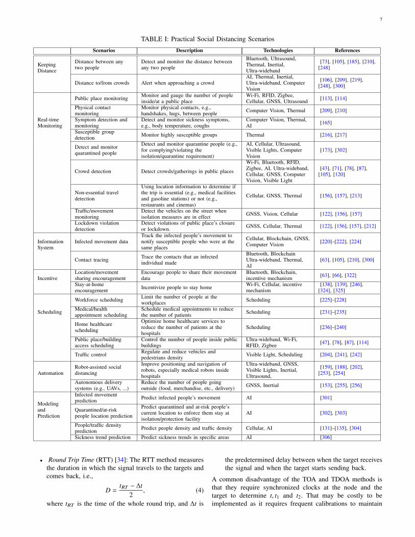
TABLE I: Practical Social Distancing Scenarios
Scenarios Description Technologies References
KeepingDistance
Distance between anytwo people
Detect and monitor the distance betweenany two people
Bluetooth, Ultrasound,Thermal, Inertial,Ultra-wideband
[73], [105], [185], [210],[248]
Distance to/from crowds Alert when approaching a crowdAI, Thermal, Inertial,Ultra-wideband, ComputerVision
[106], [209], [219],[248], [300]
Real-timeMonitoring
Public place monitoring Monitor and gauge the number of peopleinside/at a public place
Wi-Fi, RFID, Zigbee,Cellular, GNSS, Ultrasound [113], [114]
Physical contactmonitoring
Monitor physical contacts, e.g.,handshakes, hugs, between people Computer Vision, Thermal [209], [210]
Symptom detection andmonitoring
Detect and monitor sickness symptoms,e.g., body temperature, coughs
Computer Vision, Thermal,AI [165]
Susceptible groupdetection Monitor highly susceptible groups Thermal [216], [217]
Detect and monitorquarantined people
Detect and monitor quarantine people (e.g.,for complying/violating theisolation/quarantine requirement)
AI, Cellular, Ultrasound,Visible Lights, ComputerVision
[173], [302]
Crowd detection Detect crowds/gatherings in public places
Wi-Fi, Bluetooth, RFID,Zigbee, AI, Ultra-wideband,Cellular, GNSS, ComputerVision, Visible Light
[43], [71], [78], [87],[105], [120]
Non-essential traveldetection
Using location information to determine ifthe trip is essential (e.g., medical facilitiesand gasoline stations) or not (e.g.,restaurants and cinemas)
Cellular, GNSS, Thermal [156], [157], [213]
Traffic/movementmonitoring
Detect the vehicles on the street whenisolation measures are in effect GNSS, Vision, Cellular [122], [156], [157]
Lockdown violationdetection
Detect violations of public place’s closureor lockdown. GNSS, Cellular, Thermal [122], [156], [157], [212]
InformationSystem
Infected movement dataTrack the infected people’s movement tonotify susceptible people who were at thesame places
Cellular, Blockchain, GNSS,Computer Vision [220]–[222], [224]
Contact tracing Trace the contacts that an infectedindividual made
Bluetooth, BlockchainUltra-wideband, Thermal,AI
[63], [105], [210], [300]
IncentiveLocation/movementsharing encouragement
Encourage people to share their movementdata
Bluetooth, Blockchain,incentive mechanism [63], [66], [322]
Stay-at-homeencouragement Incentivize people to stay home Wi-Fi, Cellular, incentive
mechanism[138], [139], [246],
[324], [325]
Scheduling
Workforce scheduling Limit the number of people at theworkplaces Scheduling [225]–[228]
Medical/healthappointment scheduling
Schedule medical appointments to reducethe number of patients Scheduling [231]–[235]
Home healthcarescheduling
Optimize home healthcare services toreduce the number of patients at thehospitals
Scheduling [236]–[240]
Public place/buildingaccess scheduling
Control the number of people inside publicbuildings
Ultra-wideband, Wi-Fi,RFID, Zigbee [47], [78], [87], [114]
Traffic control Regulate and reduce vehicles andpedestrians density Visible Light, Scheduling [204], [241], [242]
AutomationRobot-assisted socialdistancing
Improve positioning and navigation ofrobots, especially medical robots insidehospitals
Ultra-wideband, GNSS,Visible Lights, Inertial,Ultrasound,
[159], [188], [202],[253], [254]
Autonomous deliverysystems (e.g., UAVs, ...)
Reduce the number of people goingoutside (food, merchandise, etc., delivery) GNSS, Inertial [153], [255], [256]
ModelingandPrediction
Infected movementprediction Predict infected people’s movement AI [301]
Quarantined/at-riskpeople location prediction
Predict quarantined and at-risk people’scurrent location to enforce them stay atisolation/protection facility
AI [302], [303]
People/traffic densityprediction Predict people density and traffic density Cellular, AI [131]–[135], [304]
Sickness trend prediction Predict sickness trends in specific areas AI [306]
• Round Trip Time (RTT) [34]: The RTT method measuresthe duration in which the signal travels to the targets andcomes back, i.e.,
D =tRT − ∆t
2, (4)
where tRT is the time of the whole round trip, and ∆t is
the predetermined delay between when the target receivesthe signal and when the target starts sending back.
A common disadvantage of the TOA and TDOA methods isthat they require synchronized clocks at the node and thetarget to determine t, t1 and t2. That may be costly to beimplemented as it requires frequent calibrations to maintain
8
the accuracy. Although the RTT method does not require clocksynchronization, it needs to acquire the delay ∆t which cannotbe predicted in many circumstances [35]. Consequently, extraefforts are needed to determine ∆t.
Unlike the time-based methods, the Angle-of-Arrival (AOA)method determines D by measuring the angle of the incomingsignals by using directional antennas or array of antennas. Themeasured angles can then be used in the triangulation methodto geometrically determine the target position. However, themain disadvantage of this method is that it requires extradirectional antennas which are costly to implement [34].
The Received Signal Strength Indicaton (RSSI) methodmeasures the attenuation of the signals to determine thedistance. Typically, the relationship between the RSSI anddistance can be formulated as follows [41]:
PR = α − 10n log10(d) + X, (5)
where PR is the RSSI value at the receiver (e.g., access point),d represents the distance from the user device to the accesspoint, X is a random variable (caused by the shadowing effect)which follows the Gaussian distribution with zero mean. α is aconstant value which can be known in advance and depends onfading, antennas gain, and emitted power of the user device.n is the path loss exponent which depends on the channelenvironment between each user device and the access point.Thus, based on the RSSI level of the received signals, theaccess point can estimate the position of the user device inindoor environments.
3) Position Calculation: Based on the measured signalproperties, different methods are employed to calculate thetarget’s position. Among them, Trilateration is a commonmethod which uses three reference nodes and the distancesbetween them to the target to calculate the position [34], asillustrated in Fig. 6. More specifically, using the coordinates(x1, y1), (x2, y2), (x3, y3) of the reference nodes and the corre-sponding measured distances D1,D2, and D3, the coordinate(x, y) of the target can be determined by
√(x1 − x)2 + (y1 − y)2 = D1,√(x2 − x)2 + (y2 − y)2 = D2,√(x3 − x)2 + (y3 − y)2 = D3.
(6)
Instead of using distances, the Triangulation method usesthe angles of the signal (from the AOA method) to determinethe target’s position. As illustrated in Fig. 6, if the coordinatesof two reference nodes and the corresponding measured anglesα1, α2 are known, the target’s position can be geometricallydetermined [34].
To address the uncertainty in measurements, the MaximumLikelihood Estimation (MLE) method is often employed. Thismethod utilizes the signal measurements from a number ofreference nodes (usually three or more) and applies somestatistical approaches such as the minimum variance estimationmethod [36] to calculate the target’s position while minimizingthe impact of noises in the environment [34].
III. WIRELESS TECHNOLOGIES FOR SOCIAL DISTANCING
To enable social distancing, many wireless technologiescan be adopted such as Wi-Fi, Cellular, Bluetooth, Ultra-
wideband, GNSS, Zigbee, and RFID. In this section, we firstbriefly provide the fundamentals of these technologies andthen explain how they can enable, encourage, and enforcepeople to practice social distancing. After that, we discuss thepotential applications, advantages, limitations, and feasibilityof these technologies.
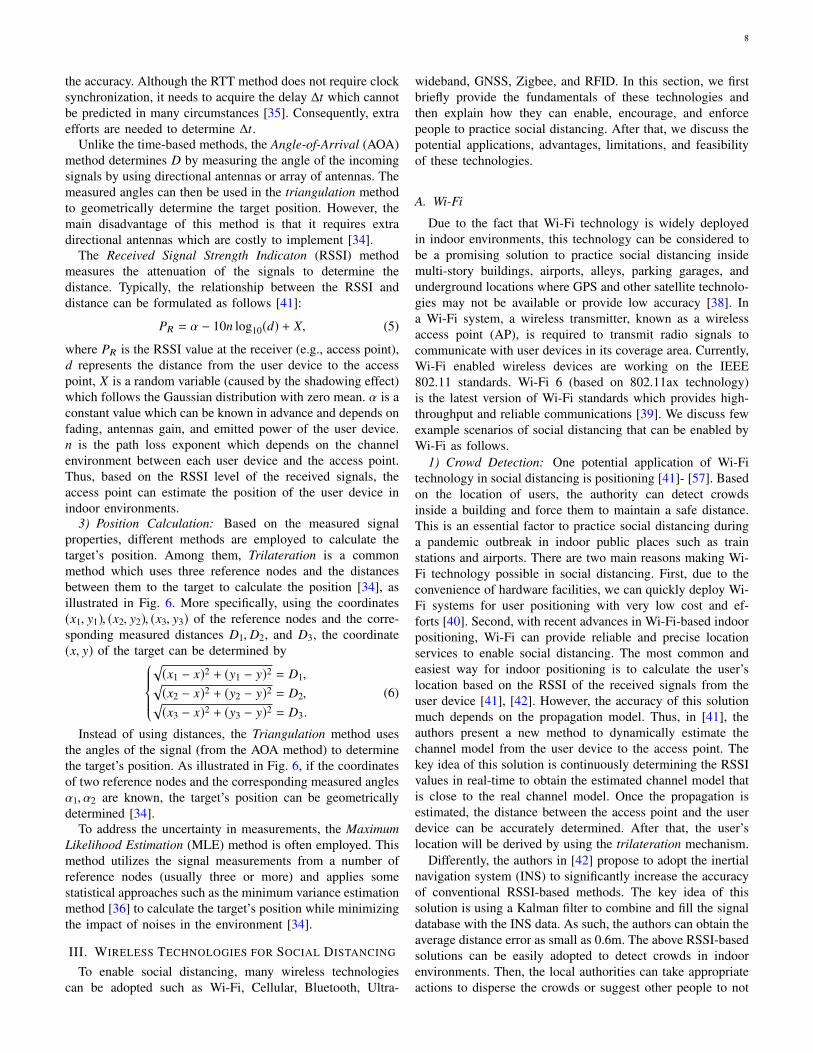
A. Wi-Fi
Due to the fact that Wi-Fi technology is widely deployedin indoor environments, this technology can be considered tobe a promising solution to practice social distancing insidemulti-story buildings, airports, alleys, parking garages, andunderground locations where GPS and other satellite technolo-gies may not be available or provide low accuracy [38]. Ina Wi-Fi system, a wireless transmitter, known as a wirelessaccess point (AP), is required to transmit radio signals tocommunicate with user devices in its coverage area. Currently,Wi-Fi enabled wireless devices are working on the IEEE802.11 standards. Wi-Fi 6 (based on 802.11ax technology)is the latest version of Wi-Fi standards which provides high-throughput and reliable communications [39]. We discuss fewexample scenarios of social distancing that can be enabled byWi-Fi as follows.
1) Crowd Detection: One potential application of Wi-Fitechnology in social distancing is positioning [41]- [57]. Basedon the location of users, the authority can detect crowdsinside a building and force them to maintain a safe distance.This is an essential factor to practice social distancing duringa pandemic outbreak in indoor public places such as trainstations and airports. There are two main reasons making Wi-Fi technology possible in social distancing. First, due to theconvenience of hardware facilities, we can quickly deploy Wi-Fi systems for user positioning with very low cost and ef-forts [40]. Second, with recent advances in Wi-Fi-based indoorpositioning, Wi-Fi can provide reliable and precise locationservices to enable social distancing. The most common andeasiest way for indoor positioning is to calculate the user’slocation based on the RSSI of the received signals from theuser device [41], [42]. However, the accuracy of this solutionmuch depends on the propagation model. Thus, in [41], theauthors present a new method to dynamically estimate thechannel model from the user device to the access point. Thekey idea of this solution is continuously determining the RSSIvalues in real-time to obtain the estimated channel model thatis close to the real channel model. Once the propagation isestimated, the distance between the access point and the userdevice can be accurately determined. After that, the user’slocation will be derived by using the trilateration mechanism.
Differently, the authors in [42] propose to adopt the inertialnavigation system (INS) to significantly increase the accuracyof conventional RSSI-based methods. The key idea of thissolution is using a Kalman filter to combine and fill the signaldatabase with the INS data. As such, the authors can obtain theaverage distance error as small as 0.6m. The above RSSI-basedsolutions can be easily adopted to detect crowds in indoorenvironments. Then, the local authorities can take appropriateactions to disperse the crowds or suggest other people to not
9
PositionCalculation
Signal MeasurementAOA
α
AOA
α
Time-based
RTT
tRT
TOA
ctt
Trilateration
D1 D2
D3
Trilateration
D1 D2
D3Triangulation
α 2
α 1
MLEMLE
Position
TDOA
c1t1
c2t2
TDOA
c1t1
c2t2
RSS
p(D)
RSS
p(D)
Signals
Fig. 6: General principle of positioning systems.
go to the place. For example, if there are too many peoplein a supermarket, the authorities can notify and recommendnew coming customers to go to other supermarkets or comein another time so that they can avoid crowds.
2) Crowd Detection in Dynamic Environments: Althoughthe RSSI-based solution can detect the user’s location withsufficient accuracy, it may not be effective in dynamic andcomplicated indoor environments such as airports or trainstations [43], [44], [45]. This is due to the effects of non-line of sight (NLOS) on the wireless signals between theuser’s device and the access point, especially in dynamicand complicated environments in which the wireless signalsare greatly scattered by obstacle shadows or people (e.g.,running and walking) [43]. Another RSSI-based indoor lo-calization technique is the fingerprinting approach (or radiomap) that locates devices based on a previously built database.In particular, this database contains the signal fingerprintscorresponding to several access points in a specific area.Nevertheless, collecting fingerprint data is time-consuming andlaborious [46], especially in large areas such as airports or trainstations. In addition, it is infeasible to directly apply the pre-obtained fingerprint database to new areas for localization [47].The main reason is that the adjustment process to apply thefingerprint database of an area to another is time-consumingand usually requires human intervention.
To address these problems, several solutions [43]–[47]are proposed to enable indoor localization in dynamic andcomplicated areas such as airports and train stations. Withthese solutions, the authorities can detect crowds and forcepeople to leave to enable social distancing during pandemicoutbreaks. Specifically, in [43], the authors show that whenthe environment changes, e.g., the presence of people in theline of sight between the user device and the access point,the performance of conventional RSSI-based localization tech-niques is greatly decreased. Thus, the authors propose anadaptive signal model fingerprinting algorithm to adapt tothe dynamic of the environment by detecting users’ positionsand updating the database simultaneously. In [47], the authorspropose a new localization technique to locate multiple usersin different areas by performing a fine-grained localization. Inaddition, the authors introduce a transfer mechanism to adjustthe fingerprint database over multiple areas to minimize humanintervention.
An interesting design is proposed in [48] to locate and track
people by using Wi-Fi technology, namely Wi-Vi (stands forWi-Fi Vision). This technology allows the authorities to trackpeople in indoor environments and detect potential crowds,so that they can take appropriate actions to enable socialdistancing, e.g., inform people not to go to potentially crowdedplaces. In particular, Wi-Vi uses an MIMO interference nullingto remove reflections from static objects and only focuses onmoving objects, e.g., a user. Moreover, the authors propose toconsider the movement of a user as an antenna array and thentrack the user by observing its RF beams. If there are manypeople having the same direction, e.g., going to the same place,the authorities can notify them to avoid forming crowds. Thus,Wi-Vi can be considered as a promising technology to enablesocial distancing.
However, to efficiently detect crowds, Wi-Fi-based local-ization systems may require several transceivers attached toeach access point to obtain high accuracy. Another problemis to differentiate between human and machine terminals. Toaddress this problem, fingerprint databases can be used todetect machine terminals which are usually placed at knownlocations. Nevertheless, this solution may not be feasible if weconsider autonomous robots in the environments, and thus canbe a potential research direction.
3) Public Place Monitoring and Access Scheduling: An-other way to apply Wi-Fi technology in social distancing isby controlling the number of people inside a building, e.g.,supermarket, shopping mall, and university. Specifically, withvarious Wi-Fi access points implemented inside the building,the number of people currently inside the building can be esti-mated based on the number of connections from user devicesto the access points. Based on this information, several actionscan be made, such as forcing people to queue before enteringthe building to maintain a safe number of people inside thefacilities at the same time. Another application is notifyingpeople who want to go to the building. Specifically, basedon the number of people inside the building, the authoritycan encourage/force them to stay home or come at a differenttime if the place is too crowded. However, the accuracy ofthis approach depends on many factors such as the number ofsmart devices one person possesses, how many devices can beconnected to a network simultaneously, and whether the userconnects to the access point as many people completely relyon their cellular connections.
10
4) Stay-at-home Encouragement: Wi-Fi technology canalso be used to encourage people to stay at home by detectingthe frequency of moving outside their houses for a particulartime, e.g., a day. Specifically, when user devices move faraway from the access point inside their houses, the connectionbetween them will be weak or lost. Based on this information,the access points can estimate the frequency of moving out oftheir house and then notify the users to encourage them tostay at home as much as possible.
Summary: Wi-Fi technology is a prominent solution toquickly and effectively enable, encourage, and force people topractice social distancing. With the current advances of Wi-Fi, the accuracy of localization systems can be significantlyimproved, resulting in effective and precise applications forsocial distancing. However, Wi-Fi-based technology is mainlyused for indoor environments as this technology requiresseveral access points for localization which may not be feasiblefor outdoor environments. For outdoor environments, otherwireless technologies, e.g., Bluetooth, GPS, and cellular tech-nologies, can be considered.
B. CellularOver the past four decades, cellular networks have seen
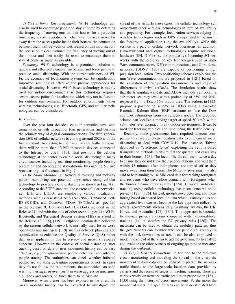
tremendous growth throughout four generations and becomethe primary way of digital communications. The fifth genera-tion (5G) of cellular networks is coming around 2020 with thefirst standard. According to the Cisco mobile traffic forecast,there will be more than 13 billion mobile devices connectedto the Internet by 2023 [117]. That positions the cellulartechnology at the center to enable social distancing in manycircumstances including real-time monitoring, people densityprediction and encouraging stay-at-home by enabling 5G livebroadcasting, as illustrated in Fig. 7.
1) Real-time Monitoring: Individual tracking and mobilitypattern monitoring are potential approaches using cellulartechnology to practice social distancing as shown in Fig. 7(a).According to the 3GPP standard, the current cellular networks,i.e., LTE and LTE-A, are employing various localizationmethods such as Assisted-GNSS (A-GNSS), Enhanced Cell-ID (E-CID), and Observed TDoA (O-TDoA) as specifiedin the Release 9; Uplink-TDoA (U-TDoA) included in theRelease 11; and with the aids of other technologies like Wi-Fi,Bluetooth, and Terrestrial Beacon System (TBS) as stated inthe Release 13 [118], [119]. Cellphone location data collectedby the current cellular network is normally used for networkoperations and managers [119] such as network planning andoptimization to enhance the Quality of Service (QoS) ratherthan user applications due to privacy and network resourceconcerns. However, in the context of social distancing, usertracking based on data of user movement history can be veryeffective, e.g., for quarantined people detection, and infectedpeople tracing. The authorities can check whether infectedpeople are violating quarantine requirements or not. In casesthey do not follow the requirements, the authorities can sendwarning messages or even perform some aggressive measures,e.g., fines and arrests, to force them to self-isolate.
Moreover, when a user has been exposed to the virus, theuser’s mobility history can be extracted to investigate the
spread of the virus. In these cases, the cellular technology canoutperform other wireless technologies in term of availabilityand popularity. For example, localization services relying onwireless technologies such as GPS always need to be run inthe foreground application (i.e., the availability), while thisservice is a part of cellular network operations. In addition,Ultra-wideband and Zigbee technologies require additionalhardware [89], [106] (i.e., the popularity). Incoming 5G net-works with the presence of key technologies such as mm-Wave communications, D2D communications, and Ultra-densenetworks (UDNs) [120] are capable of performing a highprecision localization. Two positioning schemes exploiting themm-Wave communications are proposed in [121] based onthe validation of triangulation measurements and angle ofdifferences of arrival (ADoA). The simulation results showthat the triangulate-validate and ADoA methods can obtain asub-meter accuracy level with a probability of 85% and 70%,respectively in a 18m×16m indoor area. The authors in [122]propose a positioning scheme in UDNs using a cascadedExtended Kalman filter (EKF) structure to fuse the DoAand ToA estimations from the reference nodes. The proposedscheme can localize a moving target at speed 50 km/h with asub-meter level accuracy in an outdoor environment. It can beused for tracking vehicles and monitoring the traffic density.
Recently, some governments have required telecom com-panies to share cellphone location data to implement socialdistancing to deal with COVID-19. For instance, Taiwandeployed an “electronic fence” exploiting the cellular-basedtriangulation methods to ensure that the quarantined cases stayin their homes [123]. The local officials call them twice a dayto ensure they do not leave their phones at home and visit themwithin 15 minutes after their phones are turned off or theymove away from their home. The Moscow government is alsosaid to be planning to use SIM card data for tracking foreignersand residents who have close contacts with foreigners whenthe border closure order is lifted [124]. However, individualtracking using cellular technology has risen concerns aboutprivacy [125], [126]. Instead, group/crowd detecting and mon-itoring based on shared location data which is anonymous andaggregated from carriers become the key approach utilized byseveral governments such as Italy, Germany, Austria, the UK,Korea, and Australia [127]–[130]. This approach is intendedto alleviate privacy concerns compared with individual-leveltracking (i.e., it satisfies the EU privacy rules [126]). Themetadata can be used to obtain the mobility patterns, thusthe governments can monitor whether people are complyingwith the lock-down rules or not. It can be also employed tomodel the spread of the virus to aid the governments to analyzeand evaluate the effectiveness of ongoing quarantine measuresduring the outbreak.
2) People Density Prediction: In addition to the real-timecrowd monitoring and modeling the spread of the virus, themovement history data can be utilized to predict the networktraffic thanks to the large-scale location data provided bycarriers and the recent advances of machine learning. There arevarious works on network traffic prediction proposed in [131]–[135] using the history of users’ movements. Furthermore, thenumber of users in a specific area can be also estimated from
11
Enter Text
Video multicast
Other services
Video multicast
Other services
Predicted network traffic
Network slicing
Triangulation methods
Triangulation methods
Real-time Monitoring & Infected Movement Data
People density prediction
Stay-at-home Encouragement
Enter Text
Video multicast
Other services
Predicted network traffic
Network slicing
Triangulation methods
Real-time Monitoring & Infected Movement Data
People density prediction
Stay-at-home Encouragement
Fig. 7: Cellular communications systems to support social distancing.
the network traffic of that area as illustrated in Fig. 7(b). Thus,the authorities can predict the crowd gathering in public places(e.g., shopping malls, airports, and train stations) relying onthe corresponding forecasted network traffic. Then, appropriateactions can be performed by the authorities to prevent crowdgathering in these places. For example, if the predicted numberof people entering a shopping mall exceeds a threshold, theauthorities can notify customers to avoid coming to this placeat this time or recommend them to go to other shopping mallshaving lower densities. In addition, this method can be alsoapplied in residential areas to study how often people stayhome as well as predict when they go out or the places theycome to. This can provide significant data input for networktraffic forecasts in public places. In addition, if they regularlygo to non-essential places, the authorities can warn or forcethem to stay at home as much as possible.
3) Stay-at-home Encouragement: To implement social dis-tancing, many people must do their daily activities remotelyfrom their home such as working, studying, and entertainment.Therefore, some video conference applications used to workfrom home or study online have witnessed an explosion ofdownloads. For example, the Zoom application has achievedan increase by 1,270% from 22 Feb to 22 Mar in 2020 [136]and the number of newly registered users of Microsoft Teamshas also risen 775% monthly in Italy after the full lock-downwas started [137]. As a result, 5G live broadcasting technologycan be used to encourage people to stay at home whileminimizing the impact on their work, or study (Fig. 7(c)).Especially, this is probably applicable to cases where landlineInternet is not available. There are many works to enhancethe quality of video multicast/broadcast applications by utiliz-ing the advances of 5G networks [138]–[142]. Video multi-cast/broadcast services are defined as an ultra high definitionslice in an MIMO system [138]. To improve the spectral effi-
ciency for video multicast/broadcast in the proposed system,the authors introduce a hybrid digital-analog scheme to tacklechannel condition and antenna heterogeneity. Another possiblesolution that can significantly improve qualities for videomulticasting/broadcasting is data caching. A novel cachingparadigm proposed in [139] is applied for multicast servicesin heterogeneous networks. With the awareness of multicastfiles, the proposed caching policy can select files efficientlyfor the caches. Studies in [140], [141] propose using NOMAtechniques to support multicast/broadcast by increasing thespectrum efficiency in multi-user environments. Finally, theauthors in [142] propose a video multicast orchestrationscheme for 5G UDNs which can help to improve the spectrumefficiency.
4) Infected Movement Data: Due to the omnipresence ofmobile phones and the near world-wide coverage of cellularsignals, cellular technology can be an effective tool to trackthe movement of people. Unlike in the quarantined peopledetection scenarios where these people may deliberately leavetheir phones at home, people do not have any reason to doso in the infected movement data scenario. Therefore, cellularcan be an effective technology in this scenario. The authorsof [224] summarize the methods to trace human position inoutdoor environments using base stations and indoor environ-ments using access points. However, the positioning accuracyfor outdoor environments still needs to be improved because asmall error by using the cellular network technology can causea big error in the distance measurement.
Summary: Cellular technology can be considered to be oneof most important approaches to assist social distancing. Itcan be deployed on a large scale due to its convenienceand ubiquitousness compared to other wireless technologies.It can be used to track quarantined or infected individuals.Furthermore, it can provide a unique solution to not only
12
monitor crowds in real-time, but also allow the local authoritiesto predict the forming of crowds in public areas (e.g., airports,train stations, and shopping malls) based on the forecastednetwork traffic. The low latency feature of 5G networksin data processing using edge/fog computing enables quickresponses of the authorities (e.g., send notifications instantly),for example, to prevent close contact. However, the use ofsubscriber’s location data for social distancing measures issubject to great privacy concerns from citizens (to be discussedmore details in Section V).
C. Bluetooth
With the explosive growth of Bluetooth-enabled devices,Bluetooth technology is another solution for social distanc-ing in both indoor and outdoor environments. In particu-lar, Bluetooth is a wireless technology used for short-rangewireless communications in the range from 2.4 to 2.485GHz [58], [59]. Bluetooth devices can automatically detectand connect to other devices nearby, forming a kind of ad-hoccalled piconet [59]. Recently, Bluetooth Low Energy (BLE)has been introduced as an extended version of the classicBluetooth to reduce the energy usage of devices and improvethe communication performance [59]. Given the above, theBLE localization technology possesses several advantagescompared with those of the Wi-Fi localization. First, the BLEsignals have a higher sample rate than that of the Wi-Fi signals(i.e., 0.25 Hz ∼ 2 Hz) [60]. Second, the BLE technologyconsumes less power than that of the Wi-Fi technology, andthus it can be implemented widely in handheld devices. Third,the BLE signals can be obtained from most smart devices,while Wi-Fi signals can be obtained from only access points.Finally, BLE beacons are usually powered by battery, andthereby they are more flexible and easier to deploy thanWi-Fi. It is worth noting that Bluetooth is mainly used forinfrastructureless adhoc communications in contrast to othertechnologies.
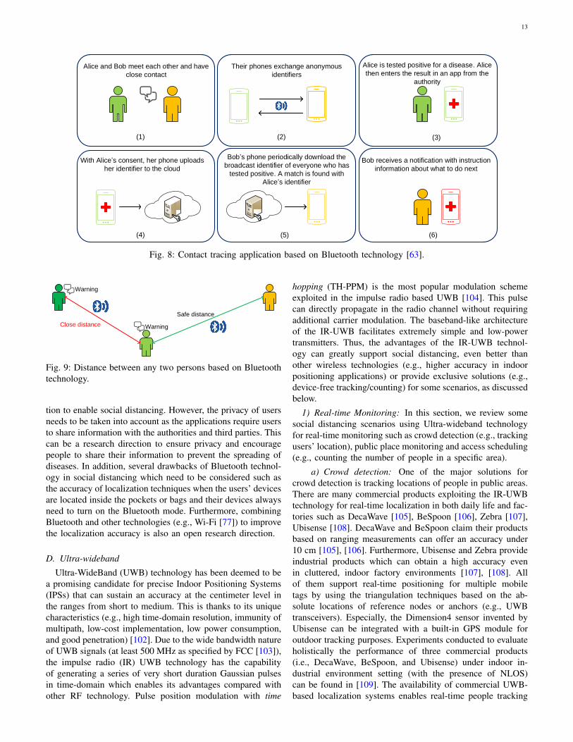
1) Contact Tracing: One application of Bluetooth in socialdistancing is contact tracing [61], [62] as illustrated in Fig. 8.The key idea is using Bluetooth to detect other users in closeproximity with their information (e.g., identifier) stored in aperson’s Bluetooth device, e.g., a mobile phone. When there isan infected case, the authorities can ask people to share theserecords as a part of a contact tracing investigation. Thereby,the authorities can detect people who may have close contactwith the infected one and notify them promptly to prevent thespreading of diseases. Several attempts to use Bluetooth incontact tracing have been reported. Apple and Google haverecently introduced a mobile application (running on bothiPhone and Android devices) that can detect other smartphonesnearby using Bluetooth technology [63]. If a person is testedpositive for a disease, he/she will enter the result in the appto inform others about that. Then, people who may have closecontact with the positive case will be notified and instructedabout what to do next. Note that a Wi-Fi or cellular connectionwould be also required to enable the app. Similar apps havebeen recently launched in Singapore [65], Europe [67], andIndia [68].
2) Crowd Detection: Bluetooth technology can be usedto detect crowds in indoor environments to practice socialdistancing with the latest advances in Bluetooth localizationtechniques [71], [73]. In particular, based on signals receivedfrom users’ Bluetooth devices, a central controller can calcu-late the positions of users and detect/predict crowds in indoorenvironments. If a crowd is detected, the local manager canforce people to leave to practice social distancing. In addition,they can advise people who want to go to the place to comeat a different time if the place is too crowded at the moment.In [71], the authors point out that with the development ofBluetooth Low Energy, Bluetooth-based indoor localizationcan be considered as a practical method to locate Bluetoothdevices in indoor environments due to its low battery cost andhigh communication performance. The authors then proposeindoor localization schemes that collect RSSI measurementsto detect the user’s location by using the triangulation mech-anism.
In [72], the authors show that the BLE technology isstrongly affected by the fast fading and interference, resultingin a low accuracy when detecting the user’s device. To improvethe accuracy of the BLE positioning, the authors run severalexperimental tests to choose the optimal parameters to set upBLE localization systems. The authors demonstrate that theBLE-based indoor localization can achieve a better perfor-mance than that of Wi-Fi localization systems. The authorsof [74] point out that the accuracy of BLE-based localization isstrongly affected by advertising channels, human movements,and human obstacles. To address these problems, they proposea dynamic AI model that can detect human obstacles by usingthree BLE advertising channels. Then, the RSSI values willbe compensated accordingly.
In [75] and [76], the authors show Wi-Fi-based and Blue-tooth based localization systems can be strongly affected bythe interference from other wireless devices operating at 2.4GHz bands. To mitigate the interference, Wi-Fi devices canuse 802.11b and 802.11g/n standards which deploy direct-sequence spread spectrum and orthogonal frequency-divisionmultiplexing signaling methods. Similarly, Bluetooth devicescan avoid interference from other wireless devices, e.g., Wi-Fi enabled devices, by using the spread-spectrum frequencyhopping technique to randomly use one of 79 different fre-quencies in Bluetooth bands. As such, the interference fromother devices is significantly reduced, thereby improving theaccuracy of localization systems.
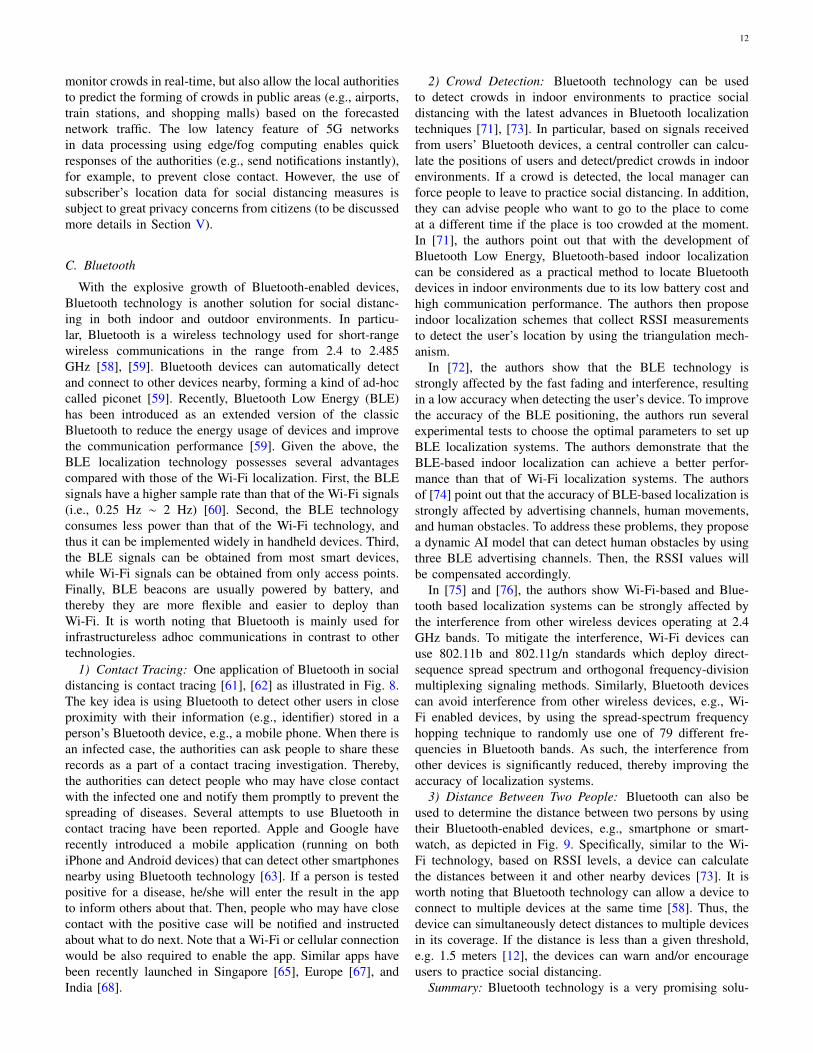
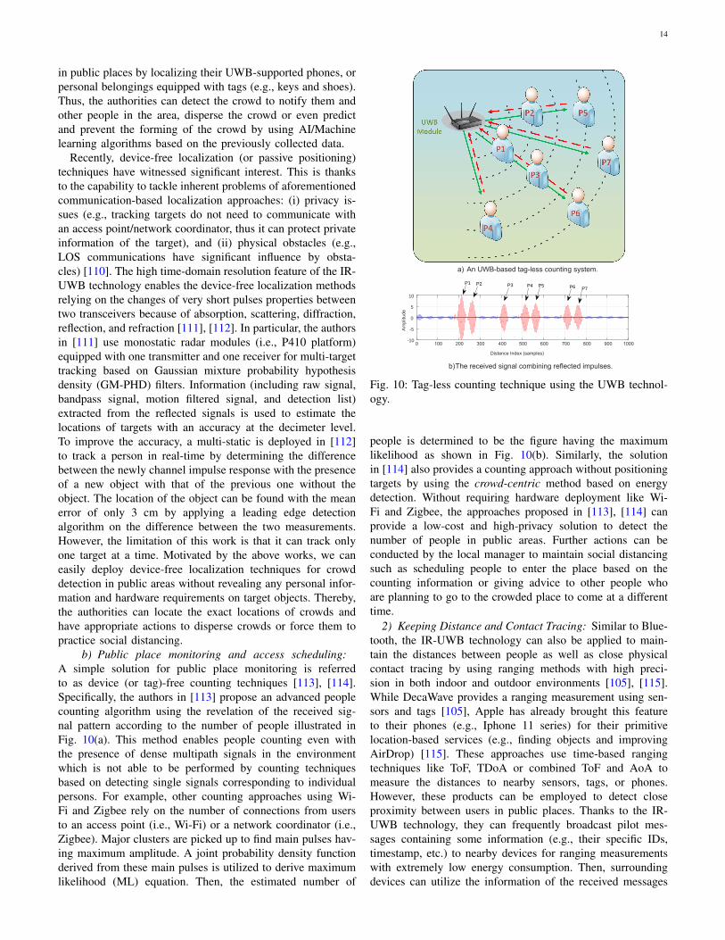
3) Distance Between Two People: Bluetooth can also beused to determine the distance between two persons by usingtheir Bluetooth-enabled devices, e.g., smartphone or smart-watch, as depicted in Fig. 9. Specifically, similar to the Wi-Fi technology, based on RSSI levels, a device can calculatethe distances between it and other nearby devices [73]. It isworth noting that Bluetooth technology can allow a device toconnect to multiple devices at the same time [58]. Thus, thedevice can simultaneously detect distances to multiple devicesin its coverage. If the distance is less than a given threshold,e.g. 1.5 meters [12], the devices can warn and/or encourageusers to practice social distancing.
Summary: Bluetooth technology is a very promising solu-
13
Alice and Bob meet each other and have
close contact
Their phones exchange anonymous
identifiers
Alice is tested positive for a disease. Alice
then enters the result in an app from the
authority
With Alice’s consent, her phone uploads
her identifier to the cloud
Bob’s phone periodically download the
broadcast identifier of everyone who has
tested positive. A match is found with
Alice’s identifier
Bob receives a notification with instruction
information about what to do next
(1) (2) (3)
(4) (5) (6)
Fig. 8: Contact tracing application based on Bluetooth technology [63].
Close distance
Safe distance
Warning
Warning
Fig. 9: Distance between any two persons based on Bluetoothtechnology.
tion to enable social distancing. However, the privacy of usersneeds to be taken into account as the applications require usersto share information with the authorities and third parties. Thiscan be a research direction to ensure privacy and encouragepeople to share their information to prevent the spreading ofdiseases. In addition, several drawbacks of Bluetooth technol-ogy in social distancing which need to be considered such asthe accuracy of localization techniques when the users’ devicesare located inside the pockets or bags and their devices alwaysneed to turn on the Bluetooth mode. Furthermore, combiningBluetooth and other technologies (e.g., Wi-Fi [77]) to improvethe localization accuracy is also an open research direction.
D. Ultra-wideband
Ultra-WideBand (UWB) technology has been deemed to bea promising candidate for precise Indoor Positioning Systems(IPSs) that can sustain an accuracy at the centimeter level inthe ranges from short to medium. This is thanks to its uniquecharacteristics (e.g., high time-domain resolution, immunity ofmultipath, low-cost implementation, low power consumption,and good penetration) [102]. Due to the wide bandwidth natureof UWB signals (at least 500 MHz as specified by FCC [103]),the impulse radio (IR) UWB technology has the capabilityof generating a series of very short duration Gaussian pulsesin time-domain which enables its advantages compared withother RF technology. Pulse position modulation with time
hopping (TH-PPM) is the most popular modulation schemeexploited in the impulse radio based UWB [104]. This pulsecan directly propagate in the radio channel without requiringadditional carrier modulation. The baseband-like architectureof the IR-UWB facilitates extremely simple and low-powertransmitters. Thus, the advantages of the IR-UWB technol-ogy can greatly support social distancing, even better thanother wireless technologies (e.g., higher accuracy in indoorpositioning applications) or provide exclusive solutions (e.g.,device-free tracking/counting) for some scenarios, as discussedbelow.
1) Real-time Monitoring: In this section, we review somesocial distancing scenarios using Ultra-wideband technologyfor real-time monitoring such as crowd detection (e.g., trackingusers’ location), public place monitoring and access scheduling(e.g., counting the number of people in a specific area).
a) Crowd detection: One of the major solutions forcrowd detection is tracking locations of people in public areas.There are many commercial products exploiting the IR-UWBtechnology for real-time localization in both daily life and fac-tories such as DecaWave [105], BeSpoon [106], Zebra [107],Ubisense [108]. DecaWave and BeSpoon claim their productsbased on ranging measurements can offer an accuracy under10 cm [105], [106]. Furthermore, Ubisense and Zebra provideindustrial products which can obtain a high accuracy evenin cluttered, indoor factory environments [107], [108]. Allof them support real-time positioning for multiple mobiletags by using the triangulation techniques based on the ab-solute locations of reference nodes or anchors (e.g., UWBtransceivers). Especially, the Dimension4 sensor invented byUbisense can be integrated with a built-in GPS module foroutdoor tracking purposes. Experiments conducted to evaluateholistically the performance of three commercial products(i.e., DecaWave, BeSpoon, and Ubisense) under indoor in-dustrial environment setting (with the presence of NLOS)can be found in [109]. The availability of commercial UWB-based localization systems enables real-time people tracking
14
in public places by localizing their UWB-supported phones, orpersonal belongings equipped with tags (e.g., keys and shoes).Thus, the authorities can detect the crowd to notify them andother people in the area, disperse the crowd or even predictand prevent the forming of the crowd by using AI/Machinelearning algorithms based on the previously collected data.
Recently, device-free localization (or passive positioning)techniques have witnessed significant interest. This is thanksto the capability to tackle inherent problems of aforementionedcommunication-based localization approaches: (i) privacy is-sues (e.g., tracking targets do not need to communicate withan access point/network coordinator, thus it can protect privateinformation of the target), and (ii) physical obstacles (e.g.,LOS communications have significant influence by obsta-cles) [110]. The high time-domain resolution feature of the IR-UWB technology enables the device-free localization methodsrelying on the changes of very short pulses properties betweentwo transceivers because of absorption, scattering, diffraction,reflection, and refraction [111], [112]. In particular, the authorsin [111] use monostatic radar modules (i.e., P410 platform)equipped with one transmitter and one receiver for multi-targettracking based on Gaussian mixture probability hypothesisdensity (GM-PHD) filters. Information (including raw signal,bandpass signal, motion filtered signal, and detection list)extracted from the reflected signals is used to estimate thelocations of targets with an accuracy at the decimeter level.To improve the accuracy, a multi-static is deployed in [112]to track a person in real-time by determining the differencebetween the newly channel impulse response with the presenceof a new object with that of the previous one without theobject. The location of the object can be found with the meanerror of only 3 cm by applying a leading edge detectionalgorithm on the difference between the two measurements.However, the limitation of this work is that it can track onlyone target at a time. Motivated by the above works, we caneasily deploy device-free localization techniques for crowddetection in public areas without revealing any personal infor-mation and hardware requirements on target objects. Thereby,the authorities can locate the exact locations of crowds andhave appropriate actions to disperse crowds or force them topractice social distancing.
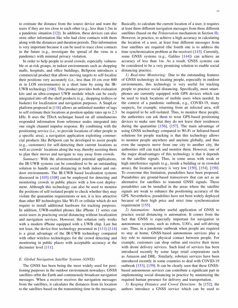
b) Public place monitoring and access scheduling:A simple solution for public place monitoring is referredto as device (or tag)-free counting techniques [113], [114].Specifically, the authors in [113] propose an advanced peoplecounting algorithm using the revelation of the received sig-nal pattern according to the number of people illustrated inFig. 10(a). This method enables people counting even withthe presence of dense multipath signals in the environmentwhich is not able to be performed by counting techniquesbased on detecting single signals corresponding to individualpersons. For example, other counting approaches using Wi-Fi and Zigbee rely on the number of connections from usersto an access point (i.e., Wi-Fi) or a network coordinator (i.e.,Zigbee). Major clusters are picked up to find main pulses hav-ing maximum amplitude. A joint probability density functionderived from these main pulses is utilized to derive maximumlikelihood (ML) equation. Then, the estimated number of
0 100 200 300 400 500 600 700 800 900 1000
Distance Index (samples)
-10
-5
0
5
10
Am
plitu
de
P1 P2 P3 P4 P5 P6 P7
a) An UWB-based tag-less counting system.
b)The received signal combining reflected impulses.
Fig. 10: Tag-less counting technique using the UWB technol-ogy.
people is determined to be the figure having the maximumlikelihood as shown in Fig. 10(b). Similarly, the solutionin [114] also provides a counting approach without positioningtargets by using the crowd-centric method based on energydetection. Without requiring hardware deployment like Wi-Fi and Zigbee, the approaches proposed in [113], [114] canprovide a low-cost and high-privacy solution to detect thenumber of people in public areas. Further actions can beconducted by the local manager to maintain social distancingsuch as scheduling people to enter the place based on thecounting information or giving advice to other people whoare planning to go to the crowded place to come at a differenttime.
2) Keeping Distance and Contact Tracing: Similar to Blue-tooth, the IR-UWB technology can also be applied to main-tain the distances between people as well as close physicalcontact tracing by using ranging methods with high preci-sion in both indoor and outdoor environments [105], [115].While DecaWave provides a ranging measurement using sen-sors and tags [105], Apple has already brought this featureto their phones (e.g., Iphone 11 series) for their primitivelocation-based services (e.g., finding objects and improvingAirDrop) [115]. These approaches use time-based rangingtechniques like ToF, TDoA or combined ToF and AoA tomeasure the distances to nearby sensors, tags, or phones.However, these products can be employed to detect closeproximity between users in public places. Thanks to the IR-UWB technology, they can frequently broadcast pilot mes-sages containing some information (e.g., their specific IDs,timestamp, etc.) to nearby devices for ranging measurementswith extremely low energy consumption. Then, surroundingdevices can utilize the information of the received messages
15
to estimate the distance from the source device and warn theusers if they are too close to each other (e.g., less than 1.5m ina pandemic situation [12]). In addition, these devices can alsostore other information like who had close contacts with themalong with the distances and duration periods. This informationis very important because it can be used to trace close contactsin the future (e.g., investigate the spread of the virus in apandemic) with minimal privacy violation.
In order to help people to avoid crowds, especially vulnera-ble or at-risk groups, in indoor environments such as shoppingmalls, hospitals, and office buildings, BeSpoon introduces acommercial product that allows moving targets to self-localizetheir positions very accurately (i.e., less than 10 cm over 600m in LOS environments) in a short time by using the IR-UWB technology [106]. This product provides both evaluationkits and an ultra-compact UWB module which can be easilyintegrated into off-the-shelf products (e.g., shopping trolleys orbaskets) for localization and navigation purposes. A SnapLocplatform proposed in [116] allows an unlimited number of tagsto self estimate their locations at position update rates up to 2.3kHz. It uses the TDoA technique based on all simultaneousresponded information from reference nodes integrated intoone single channel impulse response. By combining with thepositioning service (i.e., to provide locations of other people ina specific area), a navigation application exploiting commer-cial products like BeSpoon can be developed to assist people(e.g., customers) for self-detecting their current locations aswell as crowds’ locations along the way, thereby assisting themto plan their moves and navigate to stay away from crowds.
Summary: With the aforementioned potential applications,the IR-UWB systems can be considered to be an outstandingsolution to handle social distancing in both indoor and out-door environments. The IR-UWB based localization systemsdiscussed in [105]–[108] can be employed for detecting andmonitoring crowds in public places with a low-cost deploy-ment. Although this technology can also be used to monitorthe positions of self-isolated people to check whether they mayviolate the quarantine requirements or not, it is less attractivethan other RF technologies like Wi-Fi or cellular which do notrequire to install additional hardware for tracking purposes.In addition, UWB-enabled phones like iPhone 11 series canassist users in practicing social distancing without localizationand navigation services. However, this solution only workswith a modern iPhone equipped with a UWB chip. Last butnot least, the device-free technology presented in [111]–[114]is a great advantage of the IR-UWB technology comparedwith other wireless technologies for the crowd detecting andmonitoring in public places with acceptable accuracy at thedecimeter level [111].
E. Global Navigation Satellite Systems (GNSS)
The GNSS has been being the most widely used for posi-tioning purposes in the outdoor environment nowadays. GNSSsatellites orbit the Earth and continuously broadcast navigationmessages. When a receiver receives the navigation messagesfrom the satellites, it calculates the distances from its locationto the satellites based on the transmitting time in the messages.
Basically, to calculate the current location of a user, it requiresat least three different navigation messages from three differentsatellites (based on the Trilateration mechanism in Section II).However, in practice, to achieve a high accuracy in calculatingthe location of a user, at least four different messages fromfour satellites are required (the fourth one is to address thetime synchronization problem at the receiver) [143]. Currently,some GNSS systems (e.g., Galileo [144]) can achieve anaccuracy of less than 1m. As a result, GNSS systems canbe considered to be a very promising solution to enable socialdistancing practice.
1) Real-time Monitoring: Due to the outstanding featuresof GNSS technology in locating people, especially in outdoorenvironments, this technology is very useful for trackingpeople to practice social distancing. Specifically, most smart-phones are currently equipped with GPS devices which canbe used to track locations of mobile users when needed. Inthe context of a pandemic outbreak, e.g., COVID-19, manysuspects, for example, returning from an infected area, willbe required to be self-isolated. Thus, to monitor these people,the authorities can ask them to wear GPS-based positioningdevices to make sure that they do not leave their residencesduring the quarantine [156], [157]. The main advantage ofusing GNSS technology compared to Wi-Fi or Infrared-basedsolutions for people tracking is that this technology allowsto monitor people anywhere and anytime globally, and thuseven the suspects move from one city to another city, theauthorities still can track and monitor them. However, one ofthe major disadvantages of this technology is that it dependson the satellite signals. Thus, in some areas with weak orhigh interference signals (e.g., inside a building or in crowdedareas), the location accuracy is very low [150], [154], [158].To overcome this limitation, pseudolites have been proposed.Pseudolites are ground-based transceivers that can act as analternative for satellites to transmit GNSS signals. Thesepseudolites can be installed in the areas where the satellitesignals are weak to enhance the positioning accuracy of theGPS. Nevertheless, pseudolites have not been widely deployedbecause of their high price and strict time synchronizationrequirement [155].
2) Automation: Another useful application of GNSS topractice social distancing is automation. It comes from thefact that GNSS is especially important for navigation inautonomous systems, such as robots, UAVs, and self-drivingcars. Thus, in a pandemic outbreak when people are requiredto stay at home, GNSS-based autonomous services play akey role to minimize physical contact between people. Forexample, customers can shop online and receive their itemswith drone delivery services. Such kind of services has beenintroduced recently by some large retail corporations suchas Amazon and DHL. Similarly, robotaxi services have beenintroduced recently in some countries to deal with COVID-19outbreak [153], [159]. It can be clearly seen that these GNSS-based autonomous services can contribute a significant part inimplementing social distancing in practice by minimizing therequired human presence for delivery and transportation.
3) Keeping Distance and Crowd Detection: In [152], theauthors introduce a GNSS service which can be used to
16
determine the locations of users, thereby can warn them ifthey violate the social distancing requirements. In particular,in this service, mobile users are required to install a mobileapplication which can track the location of the users based onGPS technology. Then, the users’ locations will be updatedconstantly to the service provider. Thus, based on the users’locations, the service provider can determine whether the userviolates the social distancing requirements or not. For example,if there are more than two users locating too close to eachother (e.g., less than two meters), the service provider cansend warning messages to remind the users. Furthermore, inthe cases where a user goes to restricted areas, e.g., isolatedareas, they will receive warning messages to be aware of usingprotection measures.
4) Infected Movement Data: In the infected movement datascenario, GNSS can be a very effective technology becauseof its world-wide coverage and positioning accuracy is notthe main concern. For the outdoor environment, using GNSSalone can be sufficient for tracking the location of infectedpeople. With the omnipresence of smartphones with built-in GPS feature, the movement path of the infected peoplecan be easily determined. However, the main concern in thisscenario is that people have to turn on GPS service on theirsmartphones, which necessitate mechanisms to incentivizepeople to share their movement information. This issue willbe further discussed in Section V.
Summary: Although this GNSS-based service has manyadvantages in practicing social distancing, e.g., tracking users,keeping distance, and group monitoring, it has some short-comings which limit its applications in practice. Specifically,this service requires tracking locations of users based onGPS in a real-time manner, which may cause some extra-implementation costs and privacy issues for users. Further-more, in terms of determining the distance between twopeople, the accuracy of GNSS services is not high in general,especially for distances less than two meters. Thus, somerecent advanced GNSS technologies like [146], [148], [149],[155] can be used to improve the accuracy of the GPS.However, these technologies are still quite expensive and havenot been widely deployed for public services, and thus moreresearch in this direction should be further explored. For theprivacy issues, they will be discussed in Section V with severalsolutions such as location information protection and personalidentity protection.
F. Zigbee
Zigbee is also a potential technology that can help to enablesocial distancing. In particular, Zigbee is a standard-basedwireless communication technology for low-cost and low-power wireless networks such as wireless sensor networks.A Zigbee system consists of a central hub, e.g., network coor-dinator, and Zigbee-enabled devices. Zigbee-enabled devicescan communicate with each other at the range of up to 65feet (20 meters) with an unlimited number of hops. Comparedwith Wi-Fi and Bluetooth technologies, Zigbee is designedto be cheaper and simpler, making it possible for low-costand low-power communications for smart devices [87], [88].
Moreover, Zigbee can operate at several frequencies, such as2.4 GHz, 868 MHz, and 915 MHz. Given the above, Zigbeeis ideal for constructing mesh networks with long battery lifeand reliable communications [88]. As a result, Zigbee can beconsidered as a promising candidate in several applicationsthat enable social distancing during a pandemic outbreak.
1) Crowd Detection: One promising application of Zigbeeis detecting and tracking users’ location in indoor environ-ments. The key idea is that based on the RSSI level of thereceived signals from the user’s Zigbee-enabled device, theZigbee control hub can determine the location of the user.Several research works report that Zigbee localization systemscan achieve high accuracy with low-power and low-cost de-vices [87]. Based on the location of users, the central hub candetect crowds, i.e., many users in the same area, and notify thelocal manager to ask people to practice social distancing dur-ing a pandemic outbreak. With the state-of-the-art mechanismsin the literature, the accuracy of Zigbee localization systems issignificantly improved, making it feasible for social distancing.In [89], the authors propose a novel framework to enhancethe localization accuracy of Zigbee devices by consideringthe effect of “drift phenomenon” when users move from aplace to another place in indoor environments. The authorsthen demonstrate that the proposed framework can increase theaccuracy by up to 60% compared with conventional solutions.
Differently, in [90], the authors introduce an ensemblemechanism to further improve the localization accuracy. Inparticular, instead of using the RSSI level, the proposedsolution combines the gradient-based search, the linear leastsquare approximation, and multidimensional scaling methodstogether with spatial dependent weights of the environment toapproximate the target’s location. In [91], the authors proposean energy-efficient indoor localization system that can obtainWi-Fi fingerprints by using ZigBee interference signatures.The key idea of this work is using ZigBee interfaces todetect Wi-Fi access points which can significantly save en-ergy compared with using Wi-Fi interfaces. Furthermore, aK-nearest neighbor method with the Manhattan distance isintroduced to increase the accuracy of the localization system.The experimental results show that the proposed solution cansave 68% of energy compared with the method using Wi-Fiinterfaces. The accuracy is also improved by 87% comparedto state-of-the-art WiFi fingerprint-based approaches.
2) Public Place Monitoring and Access Scheduling: In aZigbee system, there is a central hub, known as the networkcoordinator, to control other connected devices in the network.Thus, Zigbee can be used to control the number of peoplein indoor environments. Specifically, when a person equippedwith a Zigbee-enabled device (e.g., ID card or member card)enters the place, the device will connect to the Zigbee centralhub. As such, the central hub is able to calculate the totalnumber of people inside the place at a given time. Based onthis information, the local manager can ask people to queuebefore entering the place if it is too crowded.
Summary: Zigbee technology can play an important role inenabling social distancing during pandemic outbreaks. How-ever, Zigbee is a new technology and has not been widelyadopted in our daily life, and thus limiting its practical applica-
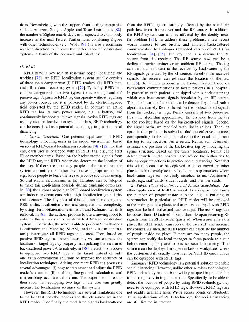
17
tions. Nevertheless, with the support from leading companiessuch as Amazon, Google, Apple, and Texas Instruments [88],the number of Zigbee-enable devices is expected to explosivelyincrease in the near future. Furthermore, combining Zigbeewith other technologies (e.g., Wi-Fi [91]) is also a promisingresearch direction to improve the performance of localizationsystems in terms of the accuracy and robustness.
G. RFID
RFID plays a key role in real-time object localizing andtracking [78]. An RFID localization system usually consistsof three main components: (i) RFID readers, (ii) RFID tags,and (iii) a data processing system [79]. Typically, RFID tagscan be categorized into two types: (i) active tags and (ii)passive tags. A passive RFID tag can operate without requiringany power source, and it is powered by the electromagneticfield generated by the RFID reader. In contrast, an activeRFID tag has its own power source, e.g., a battery, andcontinuously broadcasts its own signals. Active RFID tags areusually used in localization systems. Thus, RFID technologycan be considered as a potential technology to practice socialdistancing.
1) Crowd Detection: One potential application of RFIDtechnology is locating users in the indoor environment basedon recent RFID-based localization solutions [78]- [82]. To thatend, each user is equipped with an RFID tag, e.g., the staffID or member cards. Based on the backscattered signals fromthe RFID tag, the RFID reader can determine the location ofthe user. If there are too many people in the same area, thesystem can notify the authorities to take appropriate actions,e.g., force people to leave the area to practice social distancing.Several recent mechanisms in the literature can be adoptedto make this application possible during pandemic outbreaks.In [80], the authors propose an RFID-based localization systemfor indoor environments with high localization granularityand accuracy. The key idea of this solution is reducing theRSSI shifts, localization error, and computational complexityby using Heron-bilateration estimation and Kalman-filter driftremoval. In [81], the authors propose to use a moving robot toenhance the accuracy of a real-time RFID-based localizationsystem. In particular, the robot is able to perform SimultaneousLocalization and Mapping (SLAM), and thus it can continu-ously interrogate all RFID tags in its area. Then, based onpassive RFID tags at known locations, we can estimate thelocation of target tags by properly manipulating the measuredbackscattered power. Alternatively, in [78], the authors proposeto equipped two RFID tags at the target instead of onlyone as in conventional solutions to improve the accuracy oflocalization techniques. Adding one more RFID tag possessesseveral advantages: (i) easy to implement and adjust the RFIDreader’s antenna, (ii) enabling fine-grained calculation, and(iii) enabling accurate calibration. The experimental resultsthen show that equipping two tags at the user can greatlyincrease the localization accuracy of the system.
However, the RFID technology has several limitations dueto the fact that both the receiver and the RF source are in theRFID reader. Specifically, the modulated signals backscattered
from the RFID tag are strongly affected by the round-trippath loss from the receiver and the RF source. In addition,the RFID system can also be affected by the doubly near-far problem [83]. To address these problems, a few recentworks propose to use bistatic and ambient backscatteredcommunication technologies (extended version of RFID) forlocalization [84], [85]. The key idea is separating the RFsource from the receiver. The RF source now can be adedicated carrier emitter or an ambient RF source. The tagcan then transmit data to the receiver by backscattering theRF signals generated by the RF source. Based on the receivedsignals, the receiver can estimate the location of the tag.In [85], the authors propose a localization system based onbackscatter communications to locate patients in a hospital.In particular, each patient is equipped with a backscatter tagwhich can backscatter signals broadcast by an RF source.Then, the location of a patient can be detected by a localizationalgorithm, namely Remix, based on the backscattered signalsfrom the backscatter tags. Remix consists of two processes.First, the algorithm approximates the distance from the tagto the receiver based on the backscattered signals. Second,the signal paths are modeled with linear splines. Then, anoptimization problem is solved to find the effective distancescorresponding to the paths that close to the actual paths fromthe tag to the receiver. As a result, Remix can accuratelyestimate the position of the backscatter tag by modeling thespline structure. Based on the users’ locations, Remix candetect crowds in the hospital and advice the authorities totake appropriate actions to practice social distancing. Note thatthis solution can also be deployed to detect crowds in otherplaces such as workplaces, schools, and supermarkets wherebackscatter tags can be easily attached to users/customers’cards, e.g., staff cards, student cards, and member cards.
2) Public Place Monitoring and Access Scheduling: An-other application of RFID in social distancing is monitoringthe number of people inside a place, e.g., a building orsupermarket. In particular, an RFID reader will be deployedat the main gate of a place, and users are equipped with RFIDtags (can be both active and passive tags). The users’ tags canbroadcast their ID (active) or send their ID upon receiving RFsignals from the RFID reader (passive). When a user enters theplace, the RFID reader can receive the user’s ID and increasethe counter. As such, the RFID reader can calculate the numberof people inside the place. If there are too many people, thesystem can notify the local manager to force people to queuebefore entering the place to practice social distancing. Thissolution can be deployed in supermarkets or workplaces wherethe customer/staff usually have member/staff ID cards whichcan be equipped with RFID tags.
Summary: RFID technology is a potential solution to enablesocial distancing. However, unlike other wireless technologies,RFID technology has not been widely adopted in practice dueto its complexity in implementation. Specifically, to be able todetect the location of people by using RFID technology, theyneed to be equipped with RFID tags. However, RFID tags arenot readily available likes Wi-Fi access points or Bluetooth.Thus, applications of RFID technology for social distancingare still limited in practice.
18
Table II summarizes the technologies discussed in thisSection. Technologies that have a wide communication rangesuch as cellular and GNSS are effective solutions for thescenarios where it is necessary to track people’s location overa large area (e.g., the infected movement data scenario). Onthe other hand, technologies with a shorter communicationrange (e.g., Wi-Fi, Bluetooth, Zigbee, and RFID) are moresuitable for scenarios that involve indoor environments suchas public place monitoring. Moreover, technologies that canachieve a high positioning accuracy (e.g., Ultra-wideband andBluetooth) can be employed to keep a safe distance betweenany two people, except for GNSS since it requires a high costto maintain a sufficient accuracy. Furthermore, most of thesetechnologies are ready to be implemented and integrated withexisting systems such as smartphones. However, user privacyis an open issue for most wireless technologies. Furthermore,other emerging wireless technologies such as LoRaWAN, Z-Wave, and NFC [86] have not been well investigated in theliterature for positioning systems, and thus they could bepotential research directions for social distancing in the future.
IV. OTHER EMERGING TECHNOLOGIES FOR SOCIALDISTANCING
In addition to the wireless technologies, other emergingtechnologies such as AI, computer vision, ultrasound, inertialsensors, visible lights, and thermal also can all contribute tofacilitating social distancing. In this section, we provide a briefoverview of each technology and discuss how it can be appliedfor different social distancing scenarios.
A. Computer Vision
Computer vision technology trains computers to interpretand understand visual data such as digital images or videos.Thanks to recent breakthroughs in AI (e.g., in pattern recogni-tion and deep learning), computer vision has enabled comput-ers to accurately identify and classify objects [160]. Such ca-pabilities can play an important role in enabling, encouraging,and enforcing social distancing. For example, computer visioncan turn surveillance cameras into “smart” cameras whichcan not only monitor people but also can detect, recognize,and identify whether people comply with social distancingrequirements or not. In this section, we discuss several socialdistancing scenarios where computer vision technology canbe leveraged, including public place monitoring, and high-risk people (quarantined people and people with symptoms)monitoring and detection.
1) Public Place Monitoring: Despite government restric-tions and recommendations about social gathering, some peo-ple still do not comply with, which can cause the virus infec-tion to the community. In such context, human detection fea-tures in object detection [161], a major sub-field of computervision, can help to detect crowds in public areas through real-time images from surveillance cameras. An example scenariois described in Fig. 11(a). If the number of people in anarea does not meet the social distancing requirement (e.g.,gathering above 10 people), the authorities can be notified totake appropriate actions.
There are two main approaches to detect humans fromimages in object detection namely region-based and unified-based techniques. The former detects humans from images intwo stages including the region proposal and the processionaccording to the regions [162]. Based on this approach,several frameworks including Fast-RCNN [168] and Faster-RCNN [169] are developed in combination with ConvolutionNeural Network (CNN) [166]. In [170], the authors improvethe Faster-RCNN by proposing the Mask Regions with CNNfeatures (Mask RCNN) method which masks the boundingbox to detect the object with high accuracy while adding aminor overhead to the Faster-RCNN. Mask RCNN outper-forms previous methods by simplifying the training processand improving the accuracy in detecting humans in the imagesfor calculating the density of people in a particular area.
Although the above region-based approach has high recog-nition accuracy [170], it has high complexity, which is un-suitable for devices with limited computational capacity. Toaddress this, the unified approach is more appropriate toimplement, which can reduce the computational complexityby detecting humans from images with only one step. Thisapproach maps the pixels from image to the bounding boxgrid and class probabilities to detect humans or objects inreal-time. Following this direction, the You Only Look Once(YOLO) method proposed in [171] can detect/predict objects(even small ones) in real-time with high accuracy. In addi-tion, in [172], the authors propose the Single Shot MultiboxDetector (SSD) framework which uses a convolution networkon the image to calculate a feature map and then predict thebounding box. Through experimental results, they demonstratethat this method can detect objects faster and more accuratelythan those of both YOLO and Faster-RCNN. For public placemonitoring, both YOLO [171] and SSD [172] can be used todetect fast and accurately humans from real-time images orvideos of surveillance cameras. After identifying people, wecan use a real-time automatic counter to count and identifywhether the number of gathering people complying with socialdistancing requirements or not.
2) Detecting and Monitoring Quarantined People: To pre-vent the spread of the virus from an infected person to others,the infected person or people who had physical contact withthem must be isolated at the restricted areas or at home.For example, citizens who come back from highly infectedcountries/regions of COVID-19 are often requested to bequarantined or self-isolate for 14 days. Due to the lack offacilities, most countries require these people to self-isolate athome. In this case, the face recognition capability of computervision can help to enforce this requirement by analyzing theimages or videos from cameras to identify these people (i.e.,to check whether they breach the self-isolation requirementsor not). If these people are detected in public, the authoritiescan be notified to take appropriate actions.
Unlike object detection, the dataset including the full faceimages of the isolated people needs to be built. The face recog-nition system firstly learns from this dataset and then analyzesthe images from public surveillance cameras to identify theirappearances as in Fig. 11(b1). The authors in [173] proposea framework named DeepFace using Deep Neutral Network
19
TABLE II: Summary of Wireless Technologies Applications to Social Distancing
Technology Range Accuracy Cost Privacy Readiness Indoor/Outdoor Integrate with existing systemsWi-Fi [38],[39], [41],[43], [47],[96]
Typically up to50m indoors and100m outdoors[92]
1m - 5m[42] Low Low High Indoor Mobile phones, smart home, smart
city [53], [96]
Cellular [131],[132], [135],[138], [142]
Short to Long Less than50cm [122] Low Low to
High High Both
Smartphone, Smartwatch, Mobilephones [325], IntelligentTransportation Systems [284],[304], [305]
Ultra-wideband[105]–[108],[112], [113],[115], [116]
Short to MediumLess than10cm [105],[106], [112]
Low High Mediumto High Both
Smartphone [115], Smartindustry [105]–[107], Publictransport management [108],Commercial vehicles [105], [108]
Bluetooth[63], [65],[68],[71]–[76],[96]
Outdoor: 55m -78m. Office:15m - 19m.Home: 26m -35m [93]
1m - 2m[74] Low Low High Both Mobile phones, smart home, smart
city [73], [77], [96]
Zigbee [87],[90], [91],[96]
Up to 300+ m(line of sight).Up to 75m -100mindoor [88]
3m - 5m[87] High Low Low Indoor Mobile phones, smart home, smart
city [99]–[101]
GNSS [146],[148]–[150],[152]–[154],[156]–[159]
World-widecoverage
Outdoor lessthan 10cm[151],indoor in m
Low - High(depend onaccuracy)
Medium Yes OutdoorMobile phones [301], [303],[323], Intelligent TransportationSystems [284], [285]
RFID [78],[80], [82],[96]
Active: 100m ormore. Passive: ∼10m [94]
Less than1m [80] High Low Medium Indoor Mobile phones, smart home, smart
city [97], [98]
(a) Human Detection(b1) (b2)
(b) Face Recognition (c) Pose Estimation
Fig. 11: Computer vision technologies for social distancing (a) human detection to identify the number of people in the publicplace, (b) face recognition to identify (b1) the full face of isolated person, (b2) person with mask or person behind the maskand (c) pose estimation to detect one with coughing symptom.
(DNN) which can detect with an accuracy of 97.35% and91.4% in Labeled Faces in the Wild (LFW) and YouTubeFaces (YTF) dataset, respectively. To improve the accuracyin detecting human from surveillance cameras, some advancedtechniques can be implemented such as [174], [175] and [176].
To prevent the spread of infectious diseases such as COVID-19, people are often required to wear masks in public places,which necessitates approaches to recognize or identify peoplewith or without masks as illustrated in Fig. 11(b2). For exam-ple, the cameras in front of a public building can recognizeand send warning messages (e.g., a beep sound) to remindthe person who does not wear a mask when he/she intendsto get into the building. This idea is introduced in [182] byusing the CNN to detect people who do not wear the masks.However, this work is justs at the first step, which still requires
much more efforts to demonstrate the effectiveness as well asimprove the accuracy.
3) Symptoms Detection and Monitoring: After a few daysof being infected with the virus, the infected person may havesome symptoms such as coughing or sneezing. To minimizespreading the virus to others, it would be very helpful ifwe can detect these symptoms from people in public andinform them or the authorities. The idea here is similar tothat of using thermal imaging cameras at airports or trainstations. Specifically, detecting human behaviors, motion, andpose in computer vision can play a pivotal role [177]. Poseestimation captures a person with different parts (as illustratedin Fig. 11(c)) then detects human behaviors by studyingthe parts’ movements and their correlation. For example, acoughing person in Fig. 11(c) usually moves his hand near
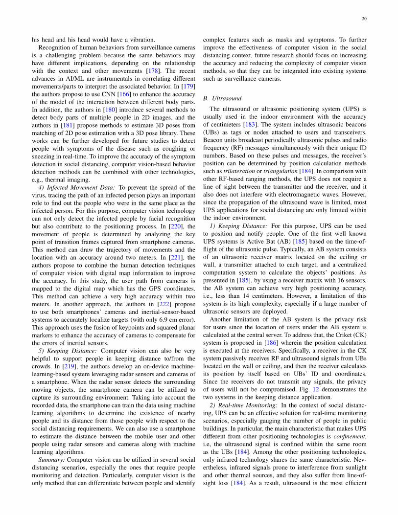
20
his head and his head would have a vibration.Recognition of human behaviors from surveillance cameras
is a challenging problem because the same behaviors mayhave different implications, depending on the relationshipwith the context and other movements [178]. The recentadvances in AI/ML are instrumentals in correlating differentmovements/parts to interpret the associated behavior. In [179]the authors propose to use CNN [166] to enhance the accuracyof the model of the interaction between different body parts.In addition, the authors in [180] introduce several methods todetect body parts of multiple people in 2D images, and theauthors in [181] propose methods to estimate 3D poses frommatching of 2D pose estimation with a 3D pose library. Theseworks can be further developed for future studies to detectpeople with symptoms of the disease such as coughing orsneezing in real-time. To improve the accuracy of the symptomdetection in social distancing, computer vision-based behaviordetection methods can be combined with other technologies,e.g., thermal imaging.
4) Infected Movement Data: To prevent the spread of thevirus, tracing the path of an infected person plays an importantrole to find out the people who were in the same place as theinfected person. For this purpose, computer vision technologycan not only detect the infected people by facial recognitionbut also contribute to the positioning process. In [220], themovement of people is determined by analyzing the keypoint of transition frames captured from smartphone cameras.This method can draw the trajectory of movements and thelocation with an accuracy around two meters. In [221], theauthors propose to combine the human detection techniquesof computer vision with digital map information to improvethe accuracy. In this study, the user path from cameras ismapped to the digital map which has the GPS coordinates.This method can achieve a very high accuracy within twometers. In another approach, the authors in [222] proposeto use both smartphones’ cameras and inertial-sensor-basedsystems to accurately localize targets (with only 6.9 cm error).This approach uses the fusion of keypoints and squared planarmarkers to enhance the accuracy of cameras to compensate forthe errors of inertial sensors.
5) Keeping Distance: Computer vision can also be veryhelpful to support people in keeping distance to/from thecrowds. In [219], the authors develop an on-device machine-learning-based system leveraging radar sensors and cameras ofa smartphone. When the radar sensor detects the surroundingmoving objects, the smartphone camera can be utilized tocapture its surrounding environment. Taking into account therecorded data, the smartphone can train the data using machinelearning algorithms to determine the existence of nearbypeople and its distance from those people with respect to thesocial distancing requirements. We can also use a smartphoneto estimate the distance between the mobile user and otherpeople using radar sensors and cameras along with machinelearning algorithms.
Summary: Computer vision can be utilized in several socialdistancing scenarios, especially the ones that require peoplemonitoring and detection. Particularly, computer vision is theonly method that can differentiate between people and identify
complex features such as masks and symptoms. To furtherimprove the effectiveness of computer vision in the socialdistancing context, future research should focus on increasingthe accuracy and reducing the complexity of computer visionmethods, so that they can be integrated into existing systemssuch as surveillance cameras.
B. Ultrasound
The ultrasound or ultrasonic positioning system (UPS) isusually used in the indoor environment with the accuracyof centimeters [183]. The system includes ultrasonic beacons(UBs) as tags or nodes attached to users and transceivers.Beacon units broadcast periodically ultrasonic pulses and radiofrequency (RF) messages simultaneously with their unique IDnumbers. Based on these pulses and messages, the receiver’sposition can be determined by position calculation methodssuch as trilateration or triangulation [184]. In comparison withother RF-based ranging methods, the UPS does not require aline of sight between the transmitter and the receiver, and italso does not interfere with electromagnetic waves. However,since the propagation of the ultrasound wave is limited, mostUPS applications for social distancing are only limited withinthe indoor environment.
1) Keeping Distance: For this purpose, UPS can be usedto position and notify people. One of the first well knownUPS systems is Active Bat (AB) [185] based on the time-of-flight of the ultrasonic pulse. Typically, an AB system consistsof an ultrasonic receiver matrix located on the ceiling orwall, a transmitter attached to each target, and a centralizedcomputation system to calculate the objects’ positions. Aspresented in [185], by using a receiver matrix with 16 sensors,the AB system can achieve very high positioning accuracy,i.e., less than 14 centimeters. However, a limitation of thissystem is its high complexity, especially if a large number ofultrasonic sensors are deployed.
Another limitation of the AB system is the privacy riskfor users since the location of users under the AB system iscalculated at the central server. To address that, the Criket (CK)system is proposed in [186] wherein the position calculationis executed at the receivers. Specifically, a receiver in the CKsystem passively receives RF and ultrasound signals from UBslocated on the wall or ceiling, and then the receiver calculatesits position by itself based on UBs’ ID and coordinates.Since the receivers do not transmit any signals, the privacyof users will not be compromised. Fig. 12 demonstrates thetwo systems in the keeping distance application.
2) Real-time Monitoring: In the context of social distanc-ing, UPS can be an effective solution for real-time monitoringscenarios, especially gauging the number of people in publicbuildings. In particular, the main characteristic that makes UPSdifferent from other positioning technologies is confinement,i.e, the ultrasound signal is confined within the same roomas the UBs [184]. Among the other positioning technologies,only infrared technology shares the same characteristic. Nev-ertheless, infrared signals prone to interference from sunlightand other thermal sources, and they also suffer from line-of-sight loss [184]. As a result, ultrasound is the most efficient

21
Fig. 12: Ultrasound application for keeping distance using a) Cricket system [186], and b) Active Bat system [185].
technology for binary positioning [184], i.e., determine if theobject is in the same room as the UBs or not. Thus, UPS can beparticularly useful in the social distancing scenarios where theexact positions of people are not as necessary as the number ofpeople inside a room (e.g., to limit the number of people). Thistechnology is more efficient because it needs a few referencenodes (e.g., UBs) to determine the binary positions of people,which can significantly reduce implementation costs.
3) Automation: Ultrasound can also be applied in the socialdistancing scenarios that utilize medical robots or UAV. Mobilerobots, especially medical robots, can play a key role inreducing the physical contact rates between the healthcarestaff (e.g., doctors and nurses) and the patients inside ahospital, thereby maintaining a suitable social distancing level.In such scenarios, UPS can help to improve the navigation ofmedical robots. In [188], a navigation system based on Wi-Fi and ultrasound is proposed for indoor robot navigation.To deal with the uncertainties which are very common incrowded places like hospitals, the system employs a PartiallyObservable Markov Decision Process, and a novel algorithmis also introduced to minimize the calibration efforts.
In the social distancing context, besides the outdoor appli-cations, UAVs can also be employed to reduce the necessityof human physical presence. For example, UAVs can be usedto deliver goods inside a building or to manage warehouseinventory. However, most of the existing studies focus on UAVnavigation for the outdoor environment, which often relies onGNSS for UAV positioning. Since GNSS’s accuracy is lowfor the indoor environment, these methods cannot be applieddirectly for UAV navigation inside a building. To address thatlimitation, a navigation system is proposed in [187], whichutilizes ultrasound, inertial sensors, GNSS, and cameras toprovide precise (less than 10cm) indoor navigation for multipleUAVs.
Summary: Ultrasound can be applied in several social
Keeping Distance AutomationAutomation
Fig. 13: Inertial-sensors-based systems for several social dis-tancing scenarios.
distancing scenarios. In the keeping distance scenarios, UPSsystems such as AB and CK can be applied directly to localizeand notify people to keep a safe distance. Moreover, dueto its confinement characteristic, ultrasound is one of themost efficient technology for binary positioning, which isparticularly useful for monitoring and gauging the numberof people inside the same room. In the automation scenarios,ultrasound can facilitate UAVs and medical robots navigations,especially for the indoor environment.
C. Inertial Sensors
In the context of social distancing, inertial-sensors-basedsystems can be applied in distance keeping and automationscenarios as illustrated in Fig. 13. For example, positioningapplications utilizing built-in inertial sensors can be developedfor smartphones which can alert the users when they get closeto each other or a crowd. Moreover, inertial sensors can beintegrated into robots and vehicle positioning systems, whichcan facilitate autonomous delivery services and medical robotnavigation. All of these scenarios can contribute to reducingthe physical contact rate between people.
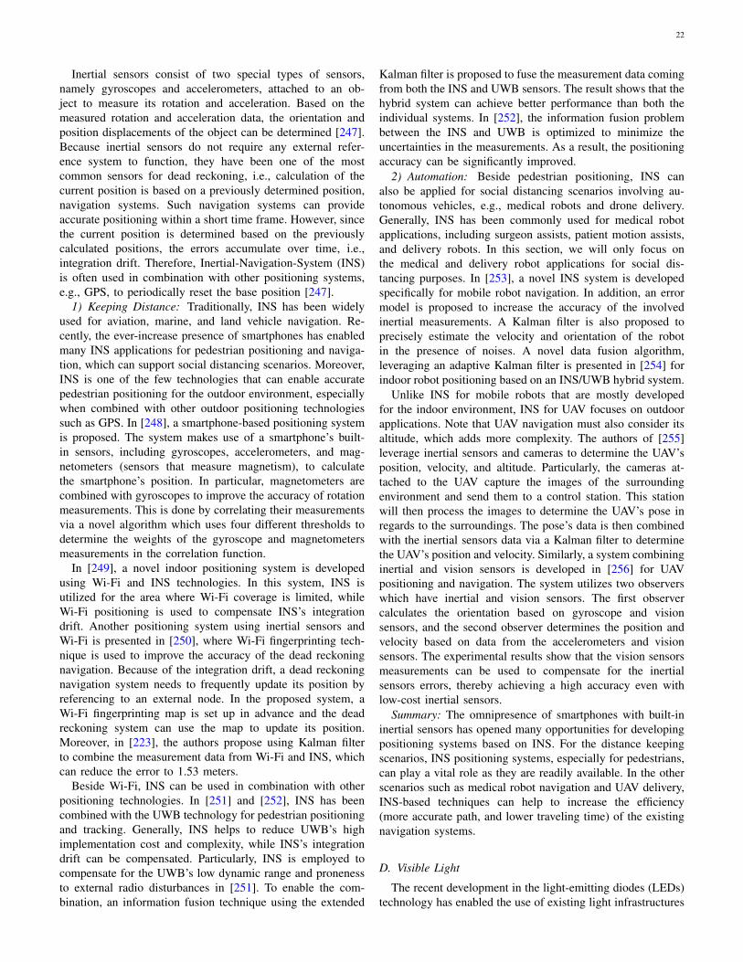
22
Inertial sensors consist of two special types of sensors,namely gyroscopes and accelerometers, attached to an ob-ject to measure its rotation and acceleration. Based on themeasured rotation and acceleration data, the orientation andposition displacements of the object can be determined [247].Because inertial sensors do not require any external refer-ence system to function, they have been one of the mostcommon sensors for dead reckoning, i.e., calculation of thecurrent position is based on a previously determined position,navigation systems. Such navigation systems can provideaccurate positioning within a short time frame. However, sincethe current position is determined based on the previouslycalculated positions, the errors accumulate over time, i.e.,integration drift. Therefore, Inertial-Navigation-System (INS)is often used in combination with other positioning systems,e.g., GPS, to periodically reset the base position [247].
1) Keeping Distance: Traditionally, INS has been widelyused for aviation, marine, and land vehicle navigation. Re-cently, the ever-increase presence of smartphones has enabledmany INS applications for pedestrian positioning and naviga-tion, which can support social distancing scenarios. Moreover,INS is one of the few technologies that can enable accuratepedestrian positioning for the outdoor environment, especiallywhen combined with other outdoor positioning technologiessuch as GPS. In [248], a smartphone-based positioning systemis proposed. The system makes use of a smartphone’s built-in sensors, including gyroscopes, accelerometers, and mag-netometers (sensors that measure magnetism), to calculatethe smartphone’s position. In particular, magnetometers arecombined with gyroscopes to improve the accuracy of rotationmeasurements. This is done by correlating their measurementsvia a novel algorithm which uses four different thresholds todetermine the weights of the gyroscope and magnetometersmeasurements in the correlation function.
In [249], a novel indoor positioning system is developedusing Wi-Fi and INS technologies. In this system, INS isutilized for the area where Wi-Fi coverage is limited, whileWi-Fi positioning is used to compensate INS’s integrationdrift. Another positioning system using inertial sensors andWi-Fi is presented in [250], where Wi-Fi fingerprinting tech-nique is used to improve the accuracy of the dead reckoningnavigation. Because of the integration drift, a dead reckoningnavigation system needs to frequently update its position byreferencing to an external node. In the proposed system, aWi-Fi fingerprinting map is set up in advance and the deadreckoning system can use the map to update its position.Moreover, in [223], the authors propose using Kalman filterto combine the measurement data from Wi-Fi and INS, whichcan reduce the error to 1.53 meters.
Beside Wi-Fi, INS can be used in combination with otherpositioning technologies. In [251] and [252], INS has beencombined with the UWB technology for pedestrian positioningand tracking. Generally, INS helps to reduce UWB’s highimplementation cost and complexity, while INS’s integrationdrift can be compensated. Particularly, INS is employed tocompensate for the UWB’s low dynamic range and pronenessto external radio disturbances in [251]. To enable the com-bination, an information fusion technique using the extended
Kalman filter is proposed to fuse the measurement data comingfrom both the INS and UWB sensors. The result shows that thehybrid system can achieve better performance than both theindividual systems. In [252], the information fusion problembetween the INS and UWB is optimized to minimize theuncertainties in the measurements. As a result, the positioningaccuracy can be significantly improved.
2) Automation: Beside pedestrian positioning, INS canalso be applied for social distancing scenarios involving au-tonomous vehicles, e.g., medical robots and drone delivery.Generally, INS has been commonly used for medical robotapplications, including surgeon assists, patient motion assists,and delivery robots. In this section, we will only focus onthe medical and delivery robot applications for social dis-tancing purposes. In [253], a novel INS system is developedspecifically for mobile robot navigation. In addition, an errormodel is proposed to increase the accuracy of the involvedinertial measurements. A Kalman filter is also proposed toprecisely estimate the velocity and orientation of the robotin the presence of noises. A novel data fusion algorithm,leveraging an adaptive Kalman filter is presented in [254] forindoor robot positioning based on an INS/UWB hybrid system.
Unlike INS for mobile robots that are mostly developedfor the indoor environment, INS for UAV focuses on outdoorapplications. Note that UAV navigation must also consider itsaltitude, which adds more complexity. The authors of [255]leverage inertial sensors and cameras to determine the UAV’sposition, velocity, and altitude. Particularly, the cameras at-tached to the UAV capture the images of the surroundingenvironment and send them to a control station. This stationwill then process the images to determine the UAV’s pose inregards to the surroundings. The pose’s data is then combinedwith the inertial sensors data via a Kalman filter to determinethe UAV’s position and velocity. Similarly, a system combininginertial and vision sensors is developed in [256] for UAVpositioning and navigation. The system utilizes two observerswhich have inertial and vision sensors. The first observercalculates the orientation based on gyroscope and visionsensors, and the second observer determines the position andvelocity based on data from the accelerometers and visionsensors. The experimental results show that the vision sensorsmeasurements can be used to compensate for the inertialsensors errors, thereby achieving a high accuracy even withlow-cost inertial sensors.
Summary: The omnipresence of smartphones with built-ininertial sensors has opened many opportunities for developingpositioning systems based on INS. For the distance keepingscenarios, INS positioning systems, especially for pedestrians,can play a vital role as they are readily available. In the otherscenarios such as medical robot navigation and UAV delivery,INS-based techniques can help to increase the efficiency(more accurate path, and lower traveling time) of the existingnavigation systems.
D. Visible Light
The recent development in the light-emitting diodes (LEDs)technology has enabled the use of existing light infrastructures
23
for communication and localization purposes due to attractivefeatures of visible lights such as reliability, robustness, andsecurity [189]–[191]. Visible light communication (VLC) sys-tems usually comprise two major components, i.e., LED lightscorresponding to transmitters to send necessary information(e.g., user data and positioning information) via visible lightsand photodetectors (e.g., photodiodes) or imaging sensors(e.g., camera) playing the role of receivers [17]. Due to theubiquitous presence of LED lights, VLC can be leveraged inmany social distancing scenarios as discussed below.
1) Real-time Monitoring: Communication systems usingvisible light (e.g., LED-based communications) can provideprecise navigation and localization solutions in indoor envi-ronments. Utilizing this technology, some applications can beimplemented to support social distancing such as tracking in-dividuals who are being quarantined, detecting and monitoringcrowds in public places as shown in Fig. 14(a).
a) Photodiode-based VLC systems: Due to many ad-vantages such as low cost and easy to implement, the VLCreceiver using photodiodes can be employed as a “tag” thatis integrated into mobile targets such as trolleys/shoppingcarts, autonomous robots, etc. People attached with thesetags can perform self-positioning based on the triangulationmethod so that they can avoid crowded areas. Furthermore,the tags’ locations can be collected by the authorities tomonitor people in public areas. Based on this location data,further actions can be carried out such as warning people byvarying the color temperature of the lights in the crowdedareas. It is worth noting that this solution will not reveal anypersonal information of users (e.g., customers) because it onlyrequires communications between VLC-based tags and lightfixtures. However, most VLC systems only provide half-duplexcommunications due to the fact that LED lights operate as therole of transmitters. Therefore, they should be combined withother wireless technologies like Bluetooth [192], [193], and In-frared [194] to enable an uplink communication with the serverfor location information exchange. Moreover, to improve theaccuracy of positioning people in indoor environments usingphotodiodes, some advanced techniques can be used such asdata fusion of AOA and RSS methods proposed in [195]and the AOA method using a multi-LED element lightingfixture introduced in [196]. One main disadvantage of thephotodiode-based VLC systems is the need for hardware (i.e.,the photodiode receiver) mounted on smart trolleys/shoppingcarts to receive light signals. Consequently, the system mightfail to detect the locations of people who do not carry them.Nevertheless, pureLiFi company has recently invented a tinyoptical front end which can be integrated into smartphonesto take benefits of the photodiode receiver in high accuracyVLC-based localization services [197].
b) Camera-based VLC systems: The rapid developmentof smartphones has enabled VLC-based applications on hand-held devices such as indoor localization and navigation ap-plications (e.g., smart retail systems [192], [193], [198]).These systems use front-facing cameras of mobile phones toreceive visible light signals contained positioning information(e.g., the LED light’s ID or location) from visible lightbeacons [199]. The captured photos collected regularly by the
front-facing camera are sent to a cloud/fog server for imageprocessing to alleviate the computation on the phone. Then,the beacon’s ID and coordinates can be extracted and sent backto the phone. After that, the AoA algorithm is implementedto estimate the location and orientation of the phone. Anattractive use case of the camera-based VLC systems [192],[193], [198] is to assist users to quickly find specific productsin shopping malls, or supermarkets. Thus, we can adopt thisfunction to implement tracking and monitoring crowds inpublic places as well as assisting people to avoid crowds in aproactive manner. It is worth noting that this solution is moreconvenient than using photodiodes since it uses front-facingcameras of smartphones as the VLC receivers, thus everyoneusing smartphones can be tracked. However, due to continuousphoto shooting, these positioning applications are very energy-consuming, which is a major drawback of camera-based VLCsystems when they are used for tracking people.
2) Automation: In public places, there is always a need forassistance in specific circumstances (e.g., information or phys-ical supports for customers, older and disabled people). Forinstance, supporting staff in supermarkets can assist customersto find products or help older/disabled people to carry theirgoods. Similar assistance scenarios can be seen in hospitals,banks, and libraries. This results in an increase in closephysical contacts between customers and assistants. Therefore,autonomous assistance systems using VLC technology canbe employed to minimize the physical contacts as shown inFig. 14(a) and (b).
a) Information assistance: Beside the navigation pur-pose, the smart retail systems [192], [193] can also provideinformation assistance services for shoppers. For example,the product description, sale information, or other necessaryinformation can be displayed on the screen when the phoneis under a certain LED light. Another example is informationassistance services in museum [200], [201]. This can help toreduce the number of close physical contacts in these places.
b) Autonomous robot: Similar to the information as-sistance systems for reducing close physical contacts, au-tonomous robots using the VLC technology for communica-tion and localization can also be deployed to assist peoplein certain circumstances, for example, elderly-assistant robots,walking-assistant robots, shopping-assistant robots, etc., [202],[203]. Moreover, visible light signals do not cause any interfer-ence to RF signals, and thus they can be effectively deployedin diverse indoor environments such as hospitals, schools, andworkplaces.
3) Traffic Control: In the context of social distancing, highdemand traffic can cause a large concentration of people ina certain area (e.g., city center). By adopting smart trafficlight systems in [204], [205], we can deploy an intelligenttraffic controlling system using the VLC technology to controllarge traffic flows as illustrated in Fig. 14(c). That can help toreduce vehicle density in public areas. The VLC technologyprovides a communication method between vehicles and thelight infrastructure (e.g., traffic lights, street lights). First,vehicles can send their information (e.g., their IDs) to thelight infrastructure by using its headlights as transmitters, thusthe system can detect and monitor the traffic flow. However,
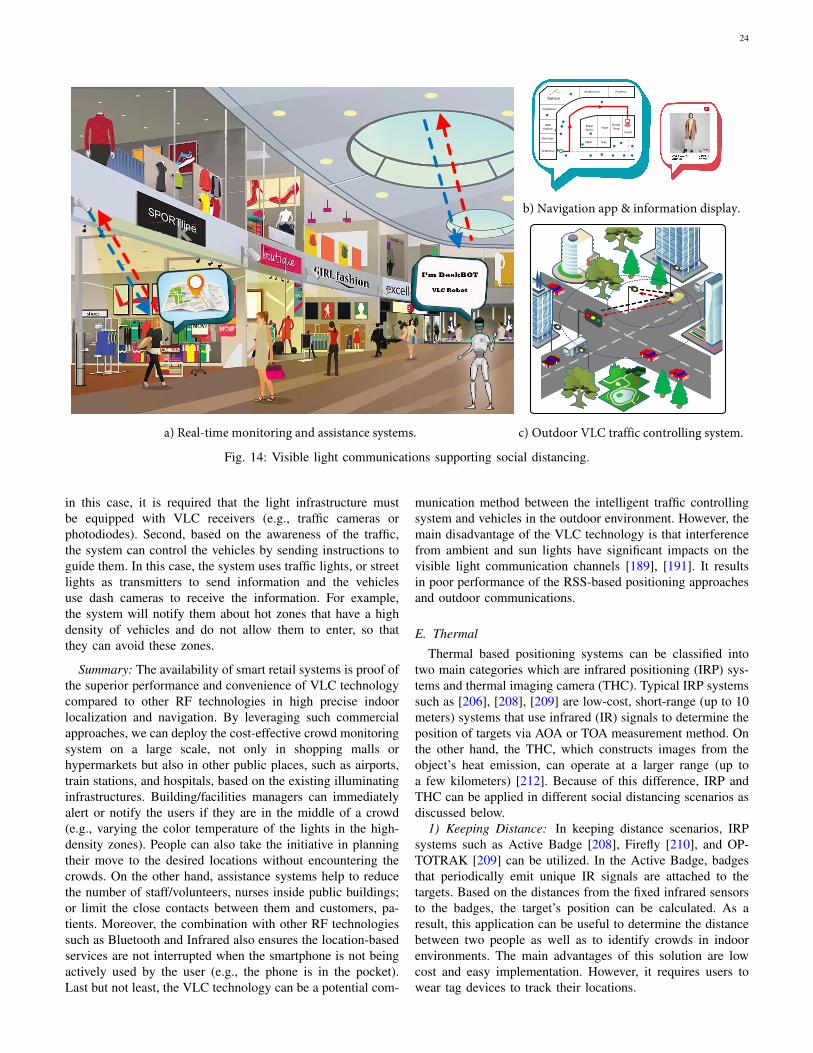
24
SPORTline
Boutique
GIRLfashion
fashion
Auditonium
Hype
Nike
Uniqlo
Rebel Sports
Priceline
ShaverShop
H&M
Excellence
SPORTline
Boutique
GIRLfashion
fashion
Auditonium
Hype
Nike
Uniqlo
Rebel Sports
Priceline
ShaverShop
H&M
Excellence
SPORTline
Boutique
GIRLfashion
fashion
Auditonium
Hype
Nike
Uniqlo
Rebel Sports
Priceline
ShaverShop
H&M
Excellence
b) Navigation app & information display.
c) Outdoor VLC traffic controlling system.a) Real-time monitoring and assistance systems.
Fig. 14: Visible light communications supporting social distancing.
in this case, it is required that the light infrastructure mustbe equipped with VLC receivers (e.g., traffic cameras orphotodiodes). Second, based on the awareness of the traffic,the system can control the vehicles by sending instructions toguide them. In this case, the system uses traffic lights, or streetlights as transmitters to send information and the vehiclesuse dash cameras to receive the information. For example,the system will notify them about hot zones that have a highdensity of vehicles and do not allow them to enter, so thatthey can avoid these zones.
Summary: The availability of smart retail systems is proof ofthe superior performance and convenience of VLC technologycompared to other RF technologies in high precise indoorlocalization and navigation. By leveraging such commercialapproaches, we can deploy the cost-effective crowd monitoringsystem on a large scale, not only in shopping malls orhypermarkets but also in other public places, such as airports,train stations, and hospitals, based on the existing illuminatinginfrastructures. Building/facilities managers can immediatelyalert or notify the users if they are in the middle of a crowd(e.g., varying the color temperature of the lights in the high-density zones). People can also take the initiative in planningtheir move to the desired locations without encountering thecrowds. On the other hand, assistance systems help to reducethe number of staff/volunteers, nurses inside public buildings;or limit the close contacts between them and customers, pa-tients. Moreover, the combination with other RF technologiessuch as Bluetooth and Infrared also ensures the location-basedservices are not interrupted when the smartphone is not beingactively used by the user (e.g., the phone is in the pocket).Last but not least, the VLC technology can be a potential com-
munication method between the intelligent traffic controllingsystem and vehicles in the outdoor environment. However, themain disadvantage of the VLC technology is that interferencefrom ambient and sun lights have significant impacts on thevisible light communication channels [189], [191]. It resultsin poor performance of the RSS-based positioning approachesand outdoor communications.
E. Thermal
Thermal based positioning systems can be classified intotwo main categories which are infrared positioning (IRP) sys-tems and thermal imaging camera (THC). Typical IRP systemssuch as [206], [208], [209] are low-cost, short-range (up to 10meters) systems that use infrared (IR) signals to determine theposition of targets via AOA or TOA measurement method. Onthe other hand, the THC, which constructs images from theobject’s heat emission, can operate at a larger range (up toa few kilometers) [212]. Because of this difference, IRP andTHC can be applied in different social distancing scenarios asdiscussed below.
1) Keeping Distance: In keeping distance scenarios, IRPsystems such as Active Badge [208], Firefly [210], and OP-TOTRAK [209] can be utilized. In the Active Badge, badgesthat periodically emit unique IR signals are attached to thetargets. Based on the distances from the fixed infrared sensorsto the badges, the target’s position can be calculated. As aresult, this application can be useful to determine the distancebetween two people as well as to identify crowds in indoorenvironments. The main advantages of this solution are lowcost and easy implementation. However, it requires users towear tag devices to track their locations.
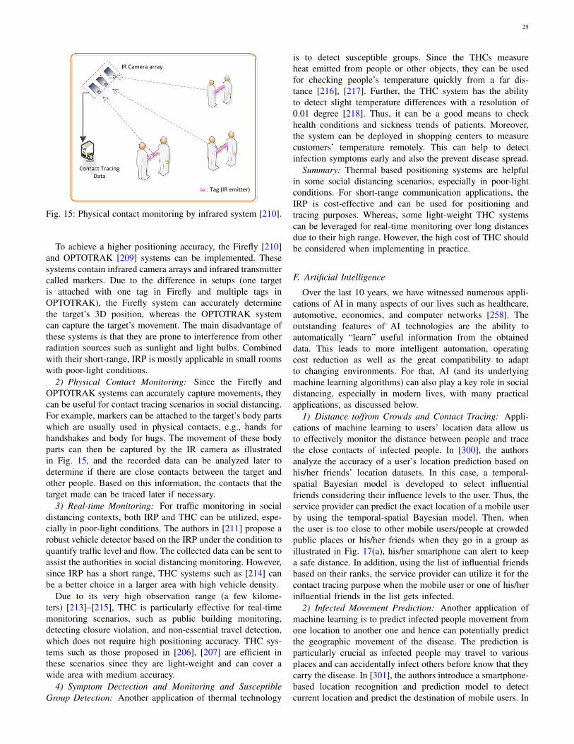
25
Fig. 15: Physical contact monitoring by infrared system [210].
To achieve a higher positioning accuracy, the Firefly [210]and OPTOTRAK [209] systems can be implemented. Thesesystems contain infrared camera arrays and infrared transmittercalled markers. Due to the difference in setups (one targetis attached with one tag in Firefly and multiple tags inOPTOTRAK), the Firefly system can accurately determinethe target’s 3D position, whereas the OPTOTRAK systemcan capture the target’s movement. The main disadvantage ofthese systems is that they are prone to interference from otherradiation sources such as sunlight and light bulbs. Combinedwith their short-range, IRP is mostly applicable in small roomswith poor-light conditions.
2) Physical Contact Monitoring: Since the Firefly andOPTOTRAK systems can accurately capture movements, theycan be useful for contact tracing scenarios in social distancing.For example, markers can be attached to the target’s body partswhich are usually used in physical contacts, e.g., hands forhandshakes and body for hugs. The movement of these bodyparts can then be captured by the IR camera as illustratedin Fig. 15, and the recorded data can be analyzed later todetermine if there are close contacts between the target andother people. Based on this information, the contacts that thetarget made can be traced later if necessary.
3) Real-time Monitoring: For traffic monitoring in socialdistancing contexts, both IRP and THC can be utilized, espe-cially in poor-light conditions. The authors in [211] propose arobust vehicle detector based on the IRP under the condition toquantify traffic level and flow. The collected data can be sent toassist the authorities in social distancing monitoring. However,since IRP has a short range, THC systems such as [214] canbe a better choice in a larger area with high vehicle density.
Due to its very high observation range (a few kilome-ters) [213]–[215], THC is particularly effective for real-timemonitoring scenarios, such as public building monitoring,detecting closure violation, and non-essential travel detection,which does not require high positioning accuracy. THC sys-tems such as those proposed in [206], [207] are efficient inthese scenarios since they are light-weight and can cover awide area with medium accuracy.
4) Symptom Dectection and Monitoring and SusceptibleGroup Detection: Another application of thermal technology
is to detect susceptible groups. Since the THCs measureheat emitted from people or other objects, they can be usedfor checking people’s temperature quickly from a far dis-tance [216], [217]. Further, the THC system has the abilityto detect slight temperature differences with a resolution of0.01 degree [218]. Thus, it can be a good means to checkhealth conditions and sickness trends of patients. Moreover,the system can be deployed in shopping centers to measurecustomers’ temperature remotely. This can help to detectinfection symptoms early and also the prevent disease spread.
Summary: Thermal based positioning systems are helpfulin some social distancing scenarios, especially in poor-lightconditions. For short-range communication applications, theIRP is cost-effective and can be used for positioning andtracing purposes. Whereas, some light-weight THC systemscan be leveraged for real-time monitoring over long distancesdue to their high range. However, the high cost of THC shouldbe considered when implementing in practice.
F. Artificial Intelligence
Over the last 10 years, we have witnessed numerous appli-cations of AI in many aspects of our lives such as healthcare,automotive, economics, and computer networks [258]. Theoutstanding features of AI technologies are the ability toautomatically “learn” useful information from the obtaineddata. This leads to more intelligent automation, operatingcost reduction as well as the great compatibility to adaptto changing environments. For that, AI (and its underlyingmachine learning algorithms) can also play a key role in socialdistancing, especially in modern lives, with many practicalapplications, as discussed below.
1) Distance to/from Crowds and Contact Tracing: Appli-cations of machine learning to users’ location data allow usto effectively monitor the distance between people and tracethe close contacts of infected people. In [300], the authorsanalyze the accuracy of a user’s location prediction based onhis/her friends’ location datasets. In this case, a temporal-spatial Bayesian model is developed to select influentialfriends considering their influence levels to the user. Thus, theservice provider can predict the exact location of a mobile userby using the temporal-spatial Bayesian model. Then, whenthe user is too close to other mobile users/people at crowdedpublic places or his/her friends when they go in a group asillustrated in Fig. 17(a), his/her smartphone can alert to keepa safe distance. In addition, using the list of influential friendsbased on their ranks, the service provider can utilize it for thecontact tracing purpose when the mobile user or one of his/herinfluential friends in the list gets infected.
2) Infected Movement Prediction: Another application ofmachine learning is to predict infected people movement fromone location to another one and hence can potentially predictthe geographic movement of the disease. The prediction isparticularly crucial as infected people may travel to variousplaces and can accidentally infect others before know that theycarry the disease. In [301], the authors introduce a smartphone-based location recognition and prediction model to detectcurrent location and predict the destination of mobile users. In
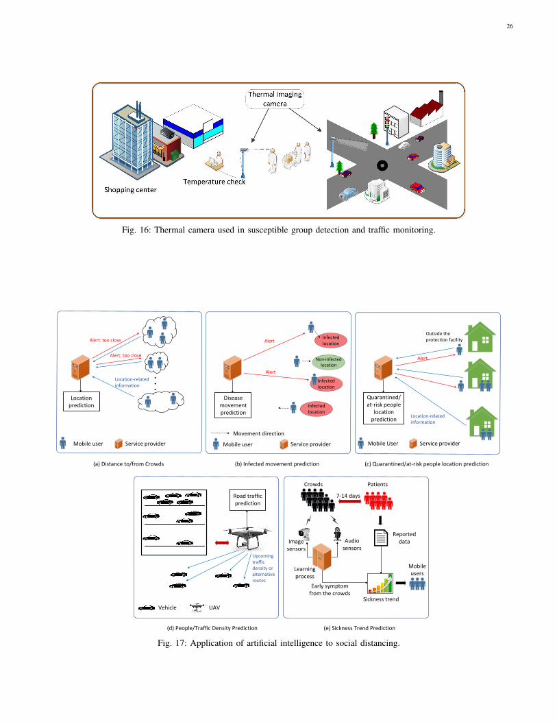
26
Fig. 16: Thermal camera used in susceptible group detection and traffic monitoring.
Early symptom from the crowds
Image sensors
Audio sensors
Learning process
Reported data
Sickness trend prediction
CrowdsPatient
s7-14 days
. . .
Mobile User
(a) Distance to/from Crowds (b) Infected movement prediction (c) Quarantined/at-risk people location prediction
Service provider
Vehicle
(d) People/Traffic Density Prediction (e) Sickness Trend Prediction
UAV
Early symptom from the crowds
Image sensors
Audio sensors
Learning process
Reported data
Sickness trend
Crowds Patients
7-14 days
Mobile users
Mobile user Service provider
Location prediction
Alert: too close
Alert: too close
Location-related information
Service provider
Disease movement prediction
Mobile user
Alert
Movement direction
Quarantined/at-risk people
location prediction
Location-related information
Alert
Outside the protection facility
Road traffic prediction
Upcoming traffic density or alternative routes
Infected location
Non-infected location
Infected location
Infected location
Alert
Fig. 17: Application of artificial intelligence to social distancing.
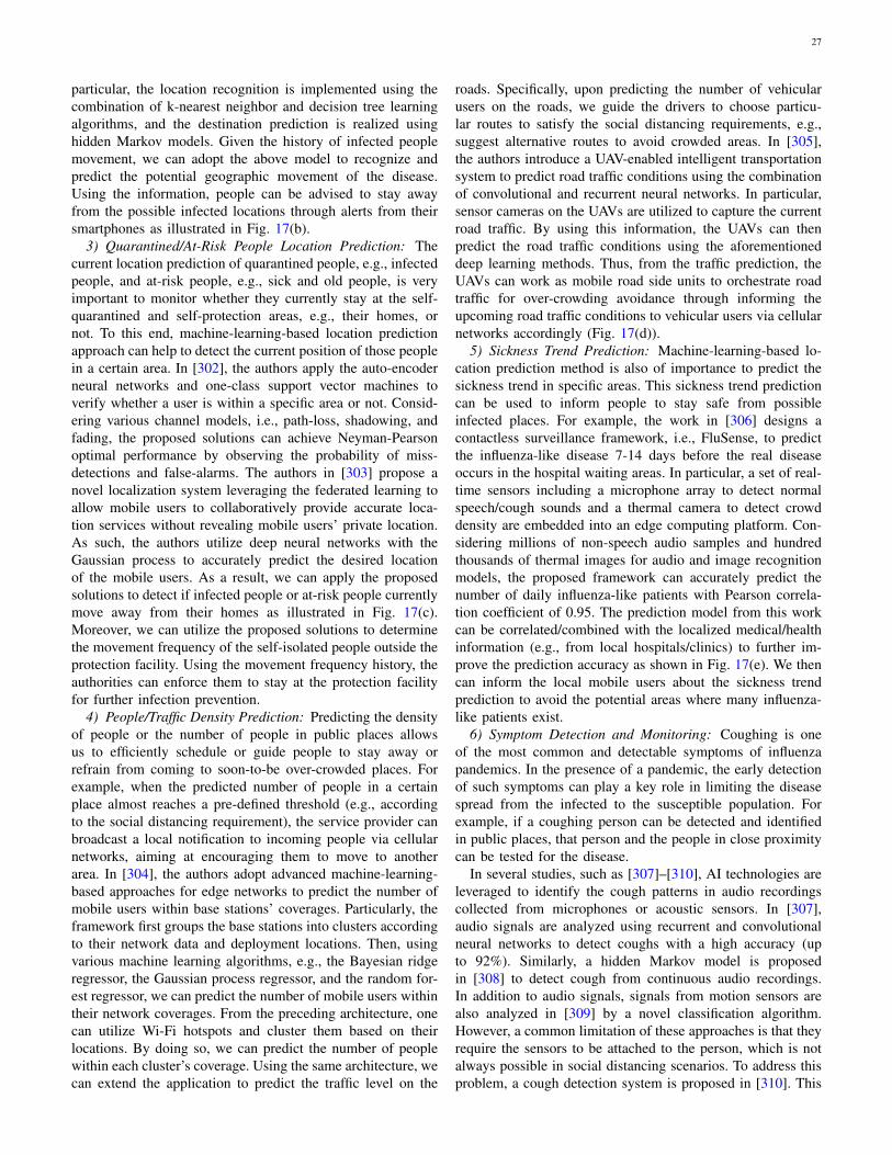
27
particular, the location recognition is implemented using thecombination of k-nearest neighbor and decision tree learningalgorithms, and the destination prediction is realized usinghidden Markov models. Given the history of infected peoplemovement, we can adopt the above model to recognize andpredict the potential geographic movement of the disease.Using the information, people can be advised to stay awayfrom the possible infected locations through alerts from theirsmartphones as illustrated in Fig. 17(b).
3) Quarantined/At-Risk People Location Prediction: Thecurrent location prediction of quarantined people, e.g., infectedpeople, and at-risk people, e.g., sick and old people, is veryimportant to monitor whether they currently stay at the self-quarantined and self-protection areas, e.g., their homes, ornot. To this end, machine-learning-based location predictionapproach can help to detect the current position of those peoplein a certain area. In [302], the authors apply the auto-encoderneural networks and one-class support vector machines toverify whether a user is within a specific area or not. Consid-ering various channel models, i.e., path-loss, shadowing, andfading, the proposed solutions can achieve Neyman-Pearsonoptimal performance by observing the probability of miss-detections and false-alarms. The authors in [303] propose anovel localization system leveraging the federated learning toallow mobile users to collaboratively provide accurate loca-tion services without revealing mobile users’ private location.As such, the authors utilize deep neural networks with theGaussian process to accurately predict the desired locationof the mobile users. As a result, we can apply the proposedsolutions to detect if infected people or at-risk people currentlymove away from their homes as illustrated in Fig. 17(c).Moreover, we can utilize the proposed solutions to determinethe movement frequency of the self-isolated people outside theprotection facility. Using the movement frequency history, theauthorities can enforce them to stay at the protection facilityfor further infection prevention.
4) People/Traffic Density Prediction: Predicting the densityof people or the number of people in public places allowsus to efficiently schedule or guide people to stay away orrefrain from coming to soon-to-be over-crowded places. Forexample, when the predicted number of people in a certainplace almost reaches a pre-defined threshold (e.g., accordingto the social distancing requirement), the service provider canbroadcast a local notification to incoming people via cellularnetworks, aiming at encouraging them to move to anotherarea. In [304], the authors adopt advanced machine-learning-based approaches for edge networks to predict the number ofmobile users within base stations’ coverages. Particularly, theframework first groups the base stations into clusters accordingto their network data and deployment locations. Then, usingvarious machine learning algorithms, e.g., the Bayesian ridgeregressor, the Gaussian process regressor, and the random for-est regressor, we can predict the number of mobile users withintheir network coverages. From the preceding architecture, onecan utilize Wi-Fi hotspots and cluster them based on theirlocations. By doing so, we can predict the number of peoplewithin each cluster’s coverage. Using the same architecture, wecan extend the application to predict the traffic level on the
roads. Specifically, upon predicting the number of vehicularusers on the roads, we guide the drivers to choose particu-lar routes to satisfy the social distancing requirements, e.g.,suggest alternative routes to avoid crowded areas. In [305],the authors introduce a UAV-enabled intelligent transportationsystem to predict road traffic conditions using the combinationof convolutional and recurrent neural networks. In particular,sensor cameras on the UAVs are utilized to capture the currentroad traffic. By using this information, the UAVs can thenpredict the road traffic conditions using the aforementioneddeep learning methods. Thus, from the traffic prediction, theUAVs can work as mobile road side units to orchestrate roadtraffic for over-crowding avoidance through informing theupcoming road traffic conditions to vehicular users via cellularnetworks accordingly (Fig. 17(d)).
5) Sickness Trend Prediction: Machine-learning-based lo-cation prediction method is also of importance to predict thesickness trend in specific areas. This sickness trend predictioncan be used to inform people to stay safe from possibleinfected places. For example, the work in [306] designs acontactless surveillance framework, i.e., FluSense, to predictthe influenza-like disease 7-14 days before the real diseaseoccurs in the hospital waiting areas. In particular, a set of real-time sensors including a microphone array to detect normalspeech/cough sounds and a thermal camera to detect crowddensity are embedded into an edge computing platform. Con-sidering millions of non-speech audio samples and hundredthousands of thermal images for audio and image recognitionmodels, the proposed framework can accurately predict thenumber of daily influenza-like patients with Pearson correla-tion coefficient of 0.95. The prediction model from this workcan be correlated/combined with the localized medical/healthinformation (e.g., from local hospitals/clinics) to further im-prove the prediction accuracy as shown in Fig. 17(e). We thencan inform the local mobile users about the sickness trendprediction to avoid the potential areas where many influenza-like patients exist.
6) Symptom Detection and Monitoring: Coughing is oneof the most common and detectable symptoms of influenzapandemics. In the presence of a pandemic, the early detectionof such symptoms can play a key role in limiting the diseasespread from the infected to the susceptible population. Forexample, if a coughing person can be detected and identifiedin public places, that person and the people in close proximitycan be tested for the disease.
In several studies, such as [307]–[310], AI technologies areleveraged to identify the cough patterns in audio recordingscollected from microphones or acoustic sensors. In [307],audio signals are analyzed using recurrent and convolutionalneural networks to detect coughs with a high accuracy (upto 92%). Similarly, a hidden Markov model is proposedin [308] to detect cough from continuous audio recordings.In addition to audio signals, signals from motion sensors arealso analyzed in [309] by a novel classification algorithm.However, a common limitation of these approaches is that theyrequire the sensors to be attached to the person, which is notalways possible in social distancing scenarios. To address thisproblem, a cough detection system is proposed in [310]. This
28
system utilizes a wireless acoustic sensors network connectedto a central server for both cough detection and localization. Inparticular, when a sound is detected, the sensors first localizethe sound source by the AOA technique. Then, the sensorssend the measured sound signals to the central server for coughidentification using a novel classification algorithm. In thesocial distancing context, this system can be applied directlyto monitor and detect coughing people in public places.Nevertheless, a limitation of this system is that the localizationand measurement errors increase significantly when the soundsource is too far from the sensors.
Summary: Various AI technologies can be leveraged tofacilitate social distancing implementations, especially in thescenarios that require modeling and prediction. In particular,AI technology can help to predict people’s locations, trafficdensity, and sickness trends. Moreover, AI-based classifica-tions algorithms can be utilized to detect symptoms such ascoughs in public areas.
Table III provides a summary of the technologies presentedin this Section. Generally, each technology has a specialcharacteristic that makes it a very effective solution for aspecific scenario. For example, Computer Vision is the onlytechnology capable of identifying a person without any at-tached device. As a result, this technology is particularlyeffective for scenarios such as quarantined people detectionand monitoring. Moreover, ultrasound signals are confined bywalls, which enables low-cost ultrasonic positioning systemto efficiently monitor people in a small room. Furthermore,since inertial sensors are built-in in most smartphones, they canbe quickly utilized for keeping distance smartphone applica-tions. In addition, visible light technology can be leveragedfor building information assistance systems which help toreduce human presence. Finally, thermal camera is the onlytechnology that can detect people over a large distance (afew kilometers) without the need for attached devices, whichmakes it an ideal solution to detect violation of quarantines orclosures.
V. OPEN ISSUES AND FUTURE RESEARCH DIRECTIONS
In this section, we discuss the open issues of social dis-tancing implementation such as security and privacy concerns,social distancing encouragement, work-from-home, and theincreased demands in healthcare appointments, home health-care services, and online services. To addressed these issues,potential solutions are also presented.
A. Security and Privacy-Preserving in Social Distancing
Most aforementioned social distancing scenarios (see Ta-ble III for more details) call for people’s private information,to a different extent, ranging from their face/appearance tolocation, travel records, or health condition/data. These data,if not protected properly, attract cyber attackers and can turnusers into victims of financial, criminal frauds, and privacyviolation [277]. Users’ data like health conditions can alsoadversely impact people’s employment opportunities or in-surance policy. Given that, to enable technology-based socialdistancing, it is critical to develop privacy-preserving and
cybersecurity solutions to ensure that users’ private data areproperly used and protected.
The general principle of users’ privacy-preserving is to keepeach individual user’s sensitive information private when theavailable data are being publicly accessed. To do so, dataprivacy-preserving mechanisms including data anonymization,randomization, and aggregation can be utilized [268]. Forexample, Apple, Google, and Facebook have developed peo-ple mobility trend reports while preserving users’ privacyduring the COVID-19 outbreak. In particular, Apple utilizesrandom and rotating identifiers to preserve mobile users’movements privacy [271]. Meanwhile, Google aggregates anduses anonymized datasets from mobile users who turn ontheir location history settings in their Android smartphones.In this case, a differential privacy approach is applied byadding random noise to the location dataset with the aimto mask individual identification of a mobile user [269].Similarly, Facebook utilizes aggregated and anonymized usermobility datasets and maps to determine the mobility trendin certain areas including the social connectedness intensityamong nearby locations [270]. In addition to the Apple’s,Google’s, and Facebook’s latest privacy-preserving implemen-tation, in the following, we will thoroughly discuss how thelatest advances in security and privacy-preserving techniquescan help to facilitate social distancing without compromisingusers’ interest/privacy.
1) Location Information Protection: To protect the exactlocation/trajectory information of participating mobile usersin social distancing, some advanced location-based privacyprotection methods can be adopted. Specifically, we cananonymize/randomize/obfuscate/perturb the exact location ofeach mobile user to avoid malicious attacks from the attackersusing the following mechanisms. For example, the authorsin [278] develop a privacy-preserving location-based frame-work to anonymize spatio-temporal trajectory datasets utilizingmachine-learning-based anonymization (MLA). In this case,the framework applies the K-means machine learning algo-rithm to cluster the trajectories from real-world GPS datasetsand ensure the K-anonymity for high-sensitive datasets. Usingthe K-anonymity [279], [280], the framework can collect loca-tion information from K mobile users within a cloaking region,i.e., the region where the mobile users’ exact locations arehidden [281], [282]. In [283], the use of K-anonymity is ex-tended into a continuous network location privacy anonymity,i.e., KDT-anonymity, which not only considers the averageanonymity size K , but also takes the average distance deviationD and the anonymity duration T into account. Leveragingthose three metrics, the mobile users under realistic vehiclemobility conditions can control the changes of anonymity anddistance deviation magnitudes over time.
The authors of [284] propose a mutually obfuscating pathsmethod which allows the vehicles to securely update accuratereal-time location to a location-based service server in thevehicular network. In this case, the vehicles first hide theirIP addresses due to the default network address translationoperated by mobile Internet service providers. Then, theygenerate fake path segments that separate from the vehi-cles’ actual paths to prevent the location-based service server
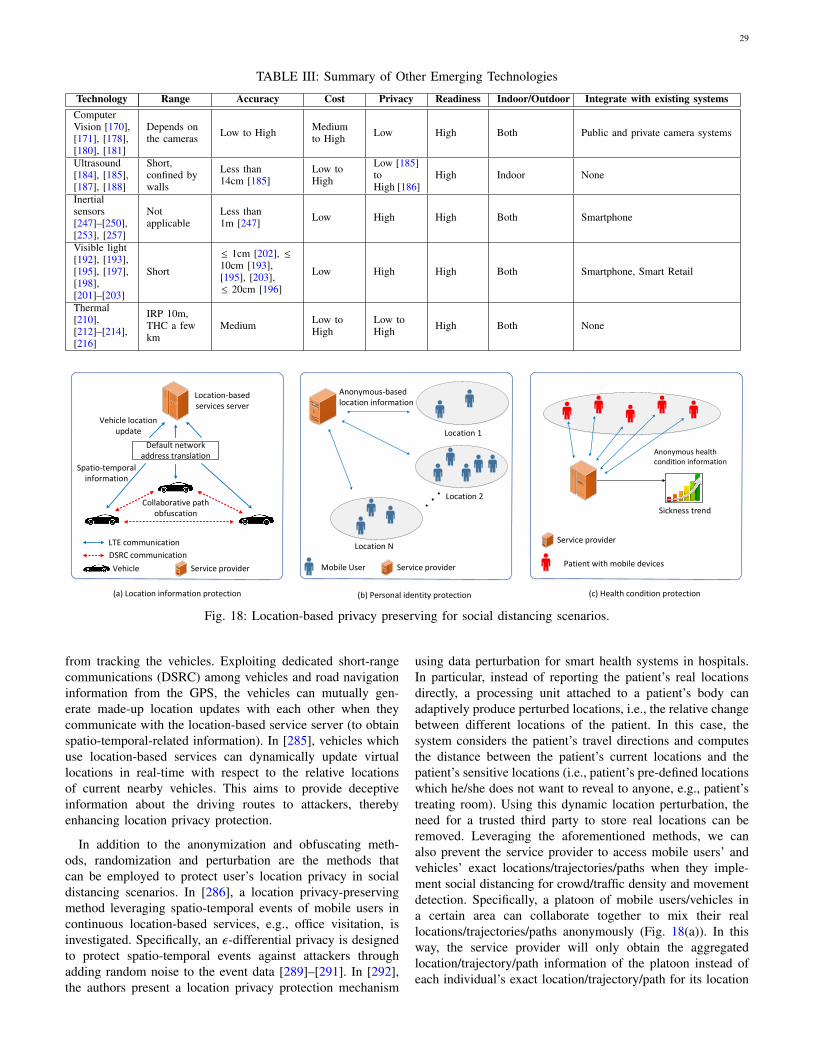
29
TABLE III: Summary of Other Emerging Technologies
Technology Range Accuracy Cost Privacy Readiness Indoor/Outdoor Integrate with existing systemsComputerVision [170],[171], [178],[180], [181]
Depends onthe cameras Low to High Medium
to High Low High Both Public and private camera systems
Ultrasound[184], [185],[187], [188]
Short,confined bywalls
Less than14cm [185]
Low toHigh
Low [185]toHigh [186]
High Indoor None
Inertialsensors[247]–[250],[253], [257]
Notapplicable
Less than1m [247] Low High High Both Smartphone
Visible light[192], [193],[195], [197],[198],[201]–[203]
Short
≤ 1cm [202], ≤10cm [193],[195], [203],≤ 20cm [196]
Low High High Both Smartphone, Smart Retail
Thermal[210],[212]–[214],[216]
IRP 10m,THC a fewkm
Medium Low toHigh
Low toHigh High Both None
Location-based services server
Default network address translation
Collaborative path obfuscation
Spatio-temporal information
Vehicle location update
LTE communication
DSRC communication
(b) Personal identity protection
(b) Contact tracing
(c) Health condition protection(a) Location information protection
Vehicle Service provider Mobile User Service provider
Location N
Location 1
Location 2
Anonymous-based location information
Mobile User Service provider
Anonymous-based combined location information
Representative user
Ad hoc
Sickness trend
Patient with mobile devices
Service provider
Anonymous health condition information
Fig. 18: Location-based privacy preserving for social distancing scenarios.
from tracking the vehicles. Exploiting dedicated short-rangecommunications (DSRC) among vehicles and road navigationinformation from the GPS, the vehicles can mutually gen-erate made-up location updates with each other when theycommunicate with the location-based service server (to obtainspatio-temporal-related information). In [285], vehicles whichuse location-based services can dynamically update virtuallocations in real-time with respect to the relative locationsof current nearby vehicles. This aims to provide deceptiveinformation about the driving routes to attackers, therebyenhancing location privacy protection.
In addition to the anonymization and obfuscating meth-ods, randomization and perturbation are the methods thatcan be employed to protect user’s location privacy in socialdistancing scenarios. In [286], a location privacy-preservingmethod leveraging spatio-temporal events of mobile users incontinuous location-based services, e.g., office visitation, isinvestigated. Specifically, an ε-differential privacy is designedto protect spatio-temporal events against attackers throughadding random noise to the event data [289]–[291]. In [292],the authors present a location privacy protection mechanism
using data perturbation for smart health systems in hospitals.In particular, instead of reporting the patient’s real locationsdirectly, a processing unit attached to a patient’s body canadaptively produce perturbed locations, i.e., the relative changebetween different locations of the patient. In this case, thesystem considers the patient’s travel directions and computesthe distance between the patient’s current locations and thepatient’s sensitive locations (i.e., patient’s pre-defined locationswhich he/she does not want to reveal to anyone, e.g., patient’streating room). Using this dynamic location perturbation, theneed for a trusted third party to store real locations can beremoved. Leveraging the aforementioned methods, we canalso prevent the service provider to access mobile users’ andvehicles’ exact locations/trajectories/paths when they imple-ment social distancing for crowd/traffic density and movementdetection. Specifically, a platoon of mobile users/vehicles ina certain area can collaborate together to mix their reallocations/trajectories/paths anonymously (Fig. 18(a)). In thisway, the service provider will only obtain the aggregatedlocation/trajectory/path information of the platoon instead ofeach individual’s exact location/trajectory/path for its location
30
privacy.2) Personal Identity Protection: In addition to protecting
mobile users’ location-related information, preserving theirpersonal identities is of importance to improve users’ accep-tance of the latest technologies to social distancing. Specif-ically, we can exchange or anonymize personal identitiesamong trusted mobile users to avoid the attackers identi-fying the actual identity of each individual user. In [293],the authors develop a pseudo-identity exchanging protocol toswap/exchange identity information among mobile users whenthey are at the same sensitive locations, e.g., hospital andresidential areas. In particular, when a mobile user receivesanother trusted user’s identity and private key, the mobileuser will verify if the encryption of another user’s identityhash function and public key is equal to the encryption of thereceived private key. If that condition holds, the mobile userwill change his/her identity with that user’s identity and viceversa.
Another method to protect personal identity in social dis-tancing scenarios is individual information privacy protectionthrough indirect- or proxy-request as proposed in [294]. Inparticular, instead of directly submitting a request to the server,a mobile user can have his/her social friends through theavailable social network resources, i.e., trusted social media,to distribute his/her request anonymously to the server. Therequest result can be returned to his/her social friends and thenforwarded to the requested mobile user, thereby preservingthe requested mobile user’s identity. In fact, there may existsome malicious friends which expose the identity of the mobileuser. Therefore, the authors in [295] investigate a user-definedprivacy-sharing framework on social network to choose his/herparticular friends who are trusted to obtain the mobile user’sidentity information. In this case, the mobile user only shareshis/her identity information with the particular friends whosepseudonyms match the mobile user’s identity through theauthorized access control. Using the same approaches fromthe above works, we can use local wireless connections, e.g.,Bluetooth and Wi-Fi Direct, to anonymously exchange actuallocation information in a mobile user group, i.e., between amobile user and his/her trusted nearby mobile users, in an adhoc way. As shown in Fig. 18(b), when the service providerrequires to collect location-related information for the currentcrowd density detection, a representative mobile user from thegroup can send the group’s anonymous location information tothe service provider, aiming at preserving the personal identityof each mobile user in the group.
Moreover, Apple and Google have recently introduced a keyschedule for contact tracing to ensure the privacy of users [63].Specifically, there are three types of key: (i) tracing key, (ii)daily tracing key, and (iii) rolling proximity identifier. Thetracing key is a 32-byte string that is generated by usinga cryptographic random number generator when the app isenabled on the device. The tracing key is securely stored onthe device. The daily tracing key is generated for every 24-hourwindow by using the SHA-256 hash function with the tracingkey. The rolling proximity identifier is a privacy-preservingidentifier which is sent in Bluetooth advertisements. Thisidentifier is generated by using the SHA-256 hash function
with the daily tracing key. Each time the Bluetooth MACaddress is changed, the app can derive a new identifier. When apositive case is diagnosed, its daily tracing keys are uploadedto a server. This server then distributes them to the clientswho use the app. Based on this information, each of theclients will be able to derive the sequence of the rollingproximity identifiers that were broadcasted from the user whotested positive. In this way, the privacy of the users can beprotected because, without the daily tracing key, one cannotobtain the user’s rolling proximity identifier. In addition, theserver operator also cannot track the user’s location or whichusers have been in proximity.
Similarly, several solutions have been proposed in [66], [67].The key idea of these solutions is generating a unique identifierand broadcasting it to nearby devices. In particular, PACT [66]regularly (every few seconds) emits a data string, called chirps,generated by cryptographic techniques based on the currenttime and the current seed of the user to ensure the privacy.Similarly, in [67], the identifier E phID (called ephemeral ID)is created as follows:
E phID = PRG(PRF(SKt, broadcast key)
), (7)
where PRF is a pseudo-random function (e.g., SHA-256),broadcast key is a fixed and public string, and PRG is astream cipher (e.g., AES in counter mode). SKt is the secretkey of each user during day t which is computed as follows:
SKt = H(SKt−1), (8)
where H is a cryptographic hash function. Upon receivingthe identifier, other nearby devices will keep it as a log. If auser is diagnosed with the disease, other users who may haveencountered the infected person will receive a warning of apotential contact.
With outstanding performance in data integrity, decentral-ization, and privacy-preserving, blockchain technology can bean effective solution to preserve privacy to enable technology-based social distancing scenarios. A blockchain is a distributeddatabase shared among users in a decentralized network. Thisdecentralized nature of blockchain ensures its immutabilityproperty, i.e., the data stored within cannot be altered withoutthe consensus of the majority of network users [69]. An-other advantage of blockchain technology is that the users’anonymity is ensured thanks to the public-private keys pairmechanism [70]. As a result, blockchain technology can ef-fectively address the personal identity issue in social distancingscenarios where people have to share their movement andlocation information but not their exact identities. For example,in the infected movement data scenario, we only need to knowthe movement path of a person, and whether or not that personis infected. In this case, the person anonymity can be ensuredwith the public-private keys pair mechanism, since there is noway to link the public key to that person true identity.
3) Health-Related Information Protection: To monitor thesickness trend in a certain place, e.g., the hospital, for thesocial distancing purpose (i.e., to inform the upcoming mobileusers not to enter a high-risk area/building), the health-relatedcondition information of visiting mobile users has to beshared to provide reliable learning dataset. To protect this
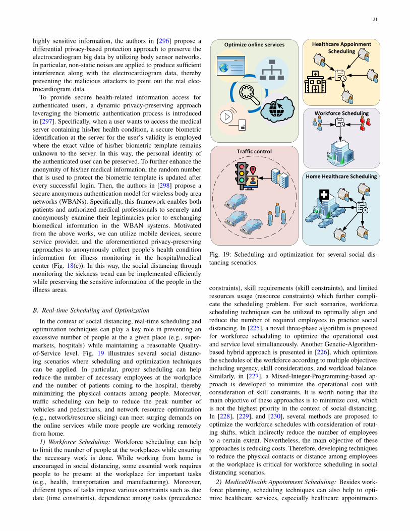
31
highly sensitive information, the authors in [296] propose adifferential privacy-based protection approach to preserve theelectrocardiogram big data by utilizing body sensor networks.In particular, non-static noises are applied to produce sufficientinterference along with the electrocardiogram data, therebypreventing the malicious attackers to point out the real elec-trocardiogram data.
To provide secure health-related information access forauthenticated users, a dynamic privacy-preserving approachleveraging the biometric authentication process is introducedin [297]. Specifically, when a user wants to access the medicalserver containing his/her health condition, a secure biometricidentification at the server for the user’s validity is employedwhere the exact value of his/her biometric template remainsunknown to the server. In this way, the personal identity ofthe authenticated user can be preserved. To further enhance theanonymity of his/her medical information, the random numberthat is used to protect the biometric template is updated afterevery successful login. Then, the authors in [298] propose asecure anonymous authentication model for wireless body areanetworks (WBANs). Specifically, this framework enables bothpatients and authorized medical professionals to securely andanonymously examine their legitimacies prior to exchangingbiomedical information in the WBAN systems. Motivatedfrom the above works, we can utilize mobile devices, secureservice provider, and the aforementioned privacy-preservingapproaches to anonymously collect people’s health conditioninformation for illness monitoring in the hospital/medicalcenter (Fig. 18(c)). In this way, the social distancing throughmonitoring the sickness trend can be implemented efficientlywhile preserving the sensitive information of the people in theillness areas.
B. Real-time Scheduling and Optimization
In the context of social distancing, real-time scheduling andoptimization techniques can play a key role in preventing anexcessive number of people at the a given place (e.g., super-markets, hospitals) while maintaining a reasonable Quality-of-Service level. Fig. 19 illustrates several social distanc-ing scenarios where scheduling and optimization techniquescan be applied. In particular, proper scheduling can helpreduce the number of necessary employees at the workplaceand the number of patients coming to the hospital, therebyminimizing the physical contacts among people. Moreover,traffic scheduling can help to reduce the peak number ofvehicles and pedestrians, and network resource optimization(e.g., network/resource slicing) can meet surging demands onthe online services while more people are working remotelyfrom home.
1) Workforce Scheduling: Workforce scheduling can helpto limit the number of people at the workplaces while ensuringthe necessary work is done. While working from home isencouraged in social distancing, some essential work requirespeople to be present at the workplace for important tasks(e.g., health, transportation and manufacturing). Moreover,different types of tasks impose various constraints such as duedate (time constraints), dependence among tasks (precedence
Workforce SchedulingWorkforce Scheduling
Healthcare AppoinmentScheduling
Healthcare AppoinmentScheduling
Optimize online servicesOptimize online services
Traffic controlTraffic control
Home Healthcare SchedulingHome Healthcare Scheduling
Fig. 19: Scheduling and optimization for several social dis-tancing scenarios.
constraints), skill requirements (skill constraints), and limitedresources usage (resource constraints) which further compli-cate the scheduling problem. For such scenarios, workforcescheduling techniques can be utilized to optimally align andreduce the number of required employees to practice socialdistancing. In [225], a novel three-phase algorithm is proposedfor workforce scheduling to optimize the operational costand service level simultaneously. Another Genetic-Algorithm-based hybrid approach is presented in [226], which optimizesthe schedules of the workforce according to multiple objectivesincluding urgency, skill considerations, and workload balance.Similarly, in [227], a Mixed-Integer-Programming-based ap-proach is developed to minimize the operational cost withconsideration of skill constraints. It is worth noting that themain objective of these approaches is to minimize cost, whichis not the highest priority in the context of social distancing.In [228], [229], and [230], several methods are proposed tooptimize the workforce schedules with consideration of rotat-ing shifts, which indirectly reduce the number of employeesto a certain extent. Nevertheless, the main objective of theseapproaches is reducing costs. Therefore, developing techniquesto reduce the physical contacts or distance among employeesat the workplace is critical for workforce scheduling in socialdistancing scenarios.
2) Medical/Health Appointment Scheduling: Besides work-force planning, scheduling techniques can also help to opti-mize healthcare services, especially healthcare appointments
32
and home healthcare services, thereby decreasing unnecessarytraffic and the number of patients coming to hospitals. Severalapproaches have been proposed to effectively schedule ap-pointments. In particular, a local search algorithm is proposedin [231] to minimize patient waiting times, doctor idle times,and tardiness (lateness). Moreover, a two-stage bounding ap-proach and a heuristic are presented in [232] and [234], re-spectively. However, a common limitation of these techniquesis that they do not take into account the uncertainties in theduration of the appointments and the possibility that the patientwill not come to the scheduled appointment. To address that,the uncertainty in the processing times (e.g., of surgeries)is considered by a conic optimization approach in [233].Similarly, a multistage stochastic linear program is developedin [235] to minimize patient waiting times and overtime, whichtakes into account the unpredictable appointment duration andunplanned cancellations. Although there are many effectiveapproaches to optimize appointment scheduling, the open issueis to develop techniques that specifically minimize or controlthe number of patients simultaneously coming to the hospitalsto maintain a suitable level of social distancing, similar to thatof the workforce scheduling scenario.
3) Home Healthcare Scheduling: Similar to appointmentscheduling, home healthcare services (HHS) can help to reducethe pressure on hospitals and traffic in the social distancingcontext. In [236], a multi-heuristics approach is proposed forHHS scheduling to minimize the total traveling times of HHSstaff. An extended problem is presented in [237], where theobjective also includes minimizing the tardiness and additionalskills and time constraints are considered. For this problem,local search-based heuristics are proposed in the paper. An-other local search-based heuristic is proposed in [238] forHHS scheduling with the objective to minimize traveling timesand optimize Quality-of-Service while considering workloadand time constraints. In [239], a Genetic-Algorithm-basedhybrid approach is proposed for HHS scheduling with uncer-tainty in patient’s demands to minimize transportation costs.Also addressing uncertainties, a branch-and-price algorithmis proposed in [240] to minimize the traveling costs anddelay of services while considering stochastic service times.Unlike in workforce planning and appointment scheduling,HHS scheduling techniques can be more effectively appliedto social distancing scenarios because they can minimize thetraveling distances while ensuring Quality-of-Service.
4) Traffic Control: Scheduling techniques have also beenapplied for traffic control. In social distancing scenarios,scheduling techniques can help to regulate the traffic level, es-pecially the number of pedestrians. In [241], a novel schedul-ing algorithm is developed for traffic control, considering bothvehicles and pedestrians, to minimize the delays. Similarly, amacroscopic model and a scheduling algorithm are proposedfor traffic control, which jointly minimize both the pedestriansand vehicle delays in [242]. Another scheduling approach isproposed in [243] that considers both pedestrians and vehicles.Different from the previously mentioned approaches, this ap-proach only focuses on minimizing pedestrian delay. Althoughthere is a vast literature on traffic scheduling techniques,the social distancing implications have not been taken into
account. For example, to maintain social distancing, a moremeaningful objective would be to reduce/constrain the peaknumber of pedestrians on the street at the same time.
5) Online Services Optimization: When social distancingmeasures are implemented, more people will be staying athome e.g., working from home. Physical meetings/gatheringswill move to virtual platforms, e.g., webinars. That results inmuch higher Internet traffic and corresponding virtual servicedemands (e.g., video streaming, broadcasting, and contentsdelivery). Therefore, optimizing online services delivery is achallenging issue in the social distancing context. Fortunately,online services optimization is a well-studied topic with asubstantial body of supporting literature.
For example, in [244], a novel algorithm is proposed to op-timize the contents delivery process in a CDN semi-federationsystem. In particular, the algorithm optimally allocates the con-tent provider’s demand to multiple Content Delivery Networks(CDNs) in the federation. The results show that the latencycan be reduced by 20% during peak hours. Another techniqueto reduce the delay and network congestion is edge-caching,which brings the contents closer to the network users. In [245],the performance of two edge-caching strategies, i.e., coded anduncoded caching, are analyzed. Moreover, two optimizationalgorithms are developed to minimize the content deliverytimes for the two caching strategies.
Besides the contents delivery, the demands on video stream-ing traffic are also much higher during social distancingimplementation because there are many people who work fromhome. In that context, emerging networking technologies canbe an effective solution. For example, an architecture utilizingHTTP adaptive streaming [246] and software-defined network-ing technology is proposed to enable video streaming overHTTP. Moreover, a novel algorithm is developed to optimallyallocates users into groups, thereby reducing communicationoverhead and leveraging network resources. The results showthat the proposed framework can increase video stability,Quality-of-Service, and resource utilization.
Scheduling and optimization are well-studied topics witha vast literature available, which can be utilized for differ-ent social distancing scenarios such as workforce, healthcareappointment, home healthcare, and traffic scheduling, and op-timization of online services delivery. Nevertheless, except forthe home healthcare service scenario, the existing techniques’objectives do not align with the objectives of social distancing.Moreover, scheduling algorithms are often developed suchthat they are only efficient for specific problems. Therefore,developing novel optimization/scheduling algorithms in oper-ations research and adopting social distancing as a new per-formance metric or design parameter is very much desirable.Furthermore, the optimization of Internet-based services suchas content delivery can help to encourage people to stay athome during social distancing periods by ensuring the servicelevels.
C. Incentive Mechanism to Encourage Social Distancing
Due to the people’s self-interested/selfish nature character-istics in their daily life [311] (especially during the pandemic
33
outbreak), incentive mechanisms can be very helpful in en-couraging people to accept or share relevant information toenable new social distancing methods. These mechanisms havebeen thoroughly discussed in crowdsourcing as implementedin [287], [316]–[319]. Therein, the service providers canprovide incentives to a large number of people to attract theircontributions in data collection for crowdsourcing process. Forexample, the contract theory-based incentive mechanism forcrowdsourcing is discussed in [316], [317]. In particular, thisapproach is considered as an efficient mechanism to lever-age common agreements between the participating entities,e.g., a service provider and its mobile users, in a certainarea under complete and incomplete information from theparticipants [312]. The use of a game theory-based incentivemechanism to encourage a set of mobile users to form acrowdsourcing community network is investigated in [287],[318]. Then, in [319], the authors utilize an auction theory-based approach incentive mechanism to stimulate mobile usersparticipation in crowdsourcing tasks such as traffic monitoring.In the following, we also highlight the existing incentivemechanisms and how they can be further adopted to encouragesocial distancing applications.
1) Distance Between any Two People and Distance to/fromCrowds: To motivate people to keep safe distances fromthemselves to others, contract theory-based incentive modelsvia D2D communications, e.g., Bluetooth, Wi-Fi Direct, canbe employed. In [313], the authors propose a contract theory-based mechanism to provide a higher reward for D2D-capablemobile users if they send the information to a requestingmobile user with a higher transmission data rate. Taking intoaccount the number of potential nearby mobile users in prox-imity, the authors in [314] introduce the same mechanism suchthat a mobile user will receive a higher payment if they canshare the information to more nearby users. Likewise, the sameapproach considering a higher reward for a mobile user whohas shorter distances in sharing its information to nearby D2Dpairs is presented in [315]. Inspired by the aforementionedworks, we can consider the contract theory-based methodalong with D2D communications to encourage people tokeep distances from other people/crowds. Specifically, mobileservice providers can be subsidized/funded or requested bythe government to provide incentives to their users to keepa distance from others when they are in public. Specifically,a service provider can offer contracts to mobile users, asillustrated in Fig. 20(a). Considering the current distancesfrom the nearby mobile users and capability to inform themthrough D2D communications, those mobile users can obtainmore rewards when they successfully keep a sufficient distance(e.g., at least 1.5 meters) from other people/users. A violation(e.g., getting closer than 1.5 meters to someone) can lead toa “penalty” (e.g., losing part of the previous rewards).
2) Contact Tracing: In a pandemic outbreak, contact trac-ing is considered as one of the most important actions tocontain the spread of the disease. To trigger each mobile userfor information sharing, e.g., mobile user’s public identity, thenetwork operator requires to offer incentives to those whocontribute such information (besides privacy-preserving solu-tions). In [316], the authors introduce a contract theory-based
incentive mechanism in a crowdsourced wireless communitynetwork. In particular, the network operator offers contracts tonetwork-sharing mobile users containing a Wi-Fi access price(for their nearby mobile users accessing the network sharing)and a subscription fee (for the network-sharing mobile users).Motivated from this work, we can also develop a contact-tracing framework which allows a mobile user to broadcasthis/her public identity to the nearby mobile users as long astheir distances are within 1.5 meters. Then, the nearby mobileusers can store this public identity in their close-contact logfiles including the time and location when they receive thatpublic identity as shown in Fig. 20(b). Mobile users who storesuch log files will pay the sharing mobile user to compensatefor the information sharing. In this way, when at least one ofthe mobile users in the log files is infected by the contagiousdisease, the mobile service provider can alert the mobile userswith the log files to implement social distancing.
3) Crowd Detection: A high density of people in specificareas can make contagious diseases to spread the infectionmore quickly due to people’s close proximity. To supportsocial distancing, an incentive mechanism approach can alsobe applied to detect the people density in public areas or thenumber of people in a building. In [317], the authors presenta tournament model-based incentive mechanism to encouragemobile users (with various performance ranks) connected tothe local wireless networks, e.g., Wi-Fi hotspots, to send thelocation and unique identifier of the networks to the serviceprovider (Fig. 20(c)). From the hotspots’ location information,the service provider can then determine the people density ineach hotspot area or the number of people in a building (whichmay have several hotspot areas). Using the above method, wecan also encourage mobile users to avoid non-essential publicplaces, e.g., restaurants and shopping malls. In this case, thereward can be adapted according to the locations and essentiallevel of the services (e.g., cinemas, restaurants, grocery stores,schools, and hospitals).
In addition to the people density detection, we can adoptincentive mechanisms to monitor the density of vehicles onthe city roads for traffic crowd avoidance purposes. In fact,the contagious diseases, e.g., coronavirus, can remain on thesurfaces for fours hours up to several days [320]. Thus,avoiding traffic jams on the roads can reduce the possibility ofdisease infection. In [321], the authors propose a reward-basedsmartphone collaboration method to support data acquisitionfor location-based services. Specifically, a client will attractsurrounding smartphone users, e.g., vehicular users on ahighway, to collaborate together with the aim to build a bigdatabase containing location information as implemented inGoogle’s Android smartphones and Apple’s iPhone [63]. Thejoining smartphone users then receive shared rewards fromthe client considering their collaboration costs. Based on thisdatabase, the client can determine the traffic levels accordingto the vehicles’ density on the roads dynamically and sellthis information to the authorities or service provider. Suchinformation can be useful for several social distancing scenar-ios such as crowd detection, traffic/movement monitoring, andtraffic control.
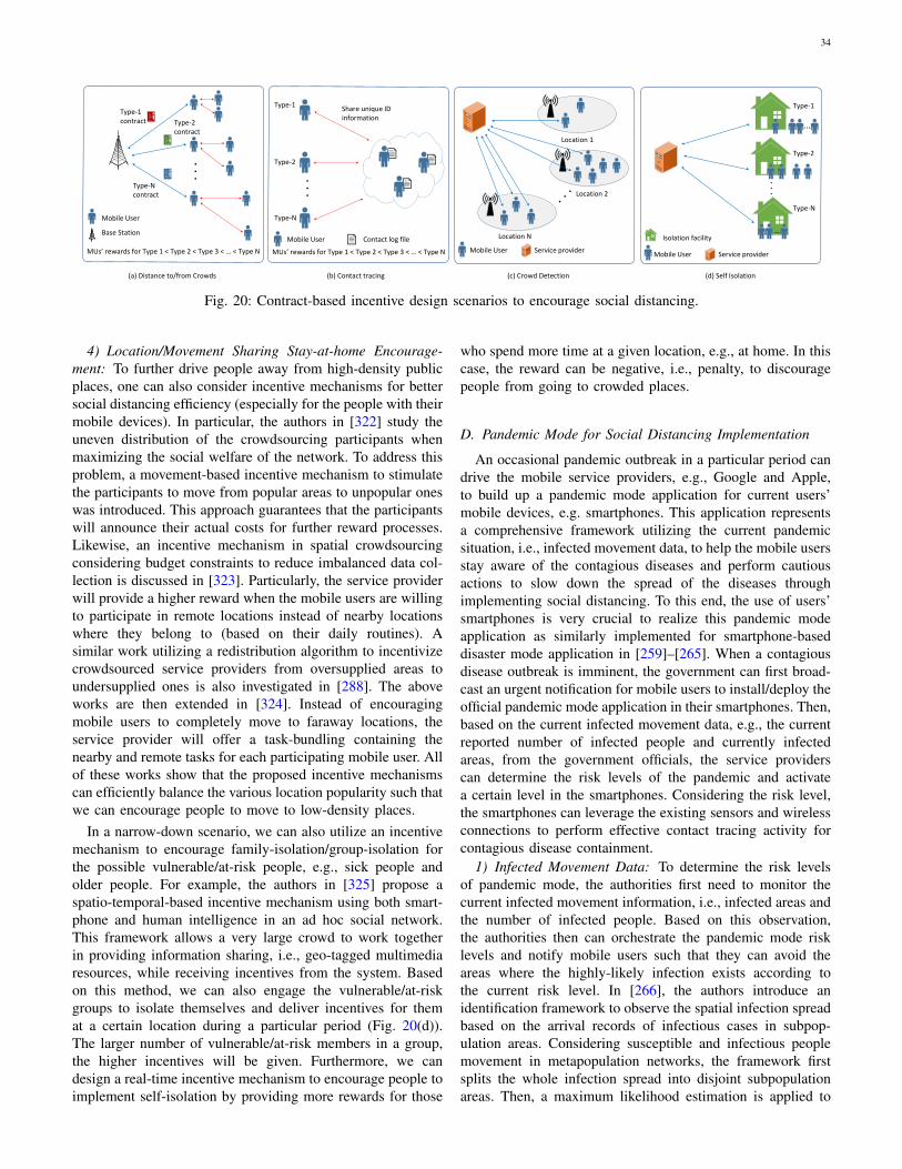
34
Contract Items
. . .
Type 1 Type 2 Type 3 Type N
Mobile User (MU)
Base Station (BS)
MU - MU
BS - MU
MUs rewards for Type 1 < Type 2 < Type 3 < < Type N
. . .
MUs rewards for Type 1 < Type 2 < Type 3 < < Type N
Type-1 contract Type-2
contract
Type-N contract
Mobile User
Base Station
MUs rewards for Type 1 < Type 2 < Type 3 < < Type N
Mobile User
Mobile User
. . .
(a) Distance to/from Crowds (b) Contact tracing (c) Crowd Detection (d) Self Isolation
. . .
Type-1
Type-2
Type-N
Share unique ID information
Contact log file
Service provider
Location N
Location 1
Location 2
Mobile User Service provider
Isolation facility
Type-1
Type-2
Type-N
...
...
Fig. 20: Contract-based incentive design scenarios to encourage social distancing.
4) Location/Movement Sharing Stay-at-home Encourage-ment: To further drive people away from high-density publicplaces, one can also consider incentive mechanisms for bettersocial distancing efficiency (especially for the people with theirmobile devices). In particular, the authors in [322] study theuneven distribution of the crowdsourcing participants whenmaximizing the social welfare of the network. To address thisproblem, a movement-based incentive mechanism to stimulatethe participants to move from popular areas to unpopular oneswas introduced. This approach guarantees that the participantswill announce their actual costs for further reward processes.Likewise, an incentive mechanism in spatial crowdsourcingconsidering budget constraints to reduce imbalanced data col-lection is discussed in [323]. Particularly, the service providerwill provide a higher reward when the mobile users are willingto participate in remote locations instead of nearby locationswhere they belong to (based on their daily routines). Asimilar work utilizing a redistribution algorithm to incentivizecrowdsourced service providers from oversupplied areas toundersupplied ones is also investigated in [288]. The aboveworks are then extended in [324]. Instead of encouragingmobile users to completely move to faraway locations, theservice provider will offer a task-bundling containing thenearby and remote tasks for each participating mobile user. Allof these works show that the proposed incentive mechanismscan efficiently balance the various location popularity such thatwe can encourage people to move to low-density places.
In a narrow-down scenario, we can also utilize an incentivemechanism to encourage family-isolation/group-isolation forthe possible vulnerable/at-risk people, e.g., sick people andolder people. For example, the authors in [325] propose aspatio-temporal-based incentive mechanism using both smart-phone and human intelligence in an ad hoc social network.This framework allows a very large crowd to work togetherin providing information sharing, i.e., geo-tagged multimediaresources, while receiving incentives from the system. Basedon this method, we can also engage the vulnerable/at-riskgroups to isolate themselves and deliver incentives for themat a certain location during a particular period (Fig. 20(d)).The larger number of vulnerable/at-risk members in a group,the higher incentives will be given. Furthermore, we candesign a real-time incentive mechanism to encourage people toimplement self-isolation by providing more rewards for those
who spend more time at a given location, e.g., at home. In thiscase, the reward can be negative, i.e., penalty, to discouragepeople from going to crowded places.
D. Pandemic Mode for Social Distancing Implementation
An occasional pandemic outbreak in a particular period candrive the mobile service providers, e.g., Google and Apple,to build up a pandemic mode application for current users’mobile devices, e.g. smartphones. This application representsa comprehensive framework utilizing the current pandemicsituation, i.e., infected movement data, to help the mobile usersstay aware of the contagious diseases and perform cautiousactions to slow down the spread of the diseases throughimplementing social distancing. To this end, the use of users’smartphones is very crucial to realize this pandemic modeapplication as similarly implemented for smartphone-baseddisaster mode application in [259]–[265]. When a contagiousdisease outbreak is imminent, the government can first broad-cast an urgent notification for mobile users to install/deploy theofficial pandemic mode application in their smartphones. Then,based on the current infected movement data, e.g., the currentreported number of infected people and currently infectedareas, from the government officials, the service providerscan determine the risk levels of the pandemic and activatea certain level in the smartphones. Considering the risk level,the smartphones can leverage the existing sensors and wirelessconnections to perform effective contact tracing activity forcontagious disease containment.
1) Infected Movement Data: To determine the risk levelsof pandemic mode, the authorities first need to monitor thecurrent infected movement information, i.e., infected areas andthe number of infected people. Based on this observation,the authorities then can orchestrate the pandemic mode risklevels and notify mobile users such that they can avoid theareas where the highly-likely infection exists according tothe current risk level. In [266], the authors introduce anidentification framework to observe the spatial infection spreadbased on the arrival records of infectious cases in subpop-ulation areas. Considering susceptible and infectious peoplemovement in metapopulation networks, the framework firstsplits the whole infection spread into disjoint subpopulationareas. Then, a maximum likelihood estimation is applied to
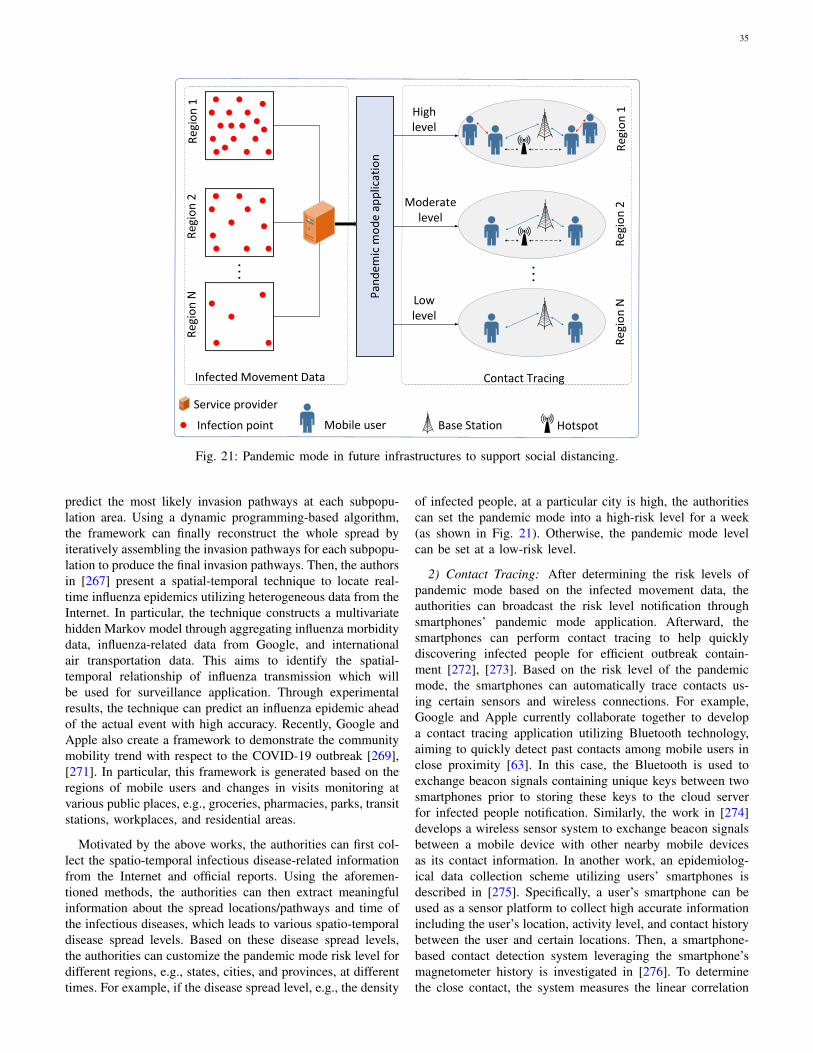
35
Smartphone 1
Smartphone 2
Linear correlation computation
Record 1
Record 2
Correlation > Threshold
No Contact
Close Contact
YES
NO
Pan
dem
ic M
od
e
High Level
Moderate Level
Low Level
Infection pointP
and
emic
Mo
de
High Level
Low Level
SmartphoneBase Station SmartphoneHotspot
(a) Contact Tracing (b) Infected Movement Data
Moderate Level
Service provider
Infection point
Pan
dem
ic m
od
e ap
plic
atio
n
High level
Low level
Mobile user Base Station Hotspot
Contact TracingInfected Movement Data
Moderatelevel
Service provider
Reg
ion
1R
egio
n 2
Reg
ion
N
. . .
Reg
ion
1R
egio
n 2
Reg
ion
N
. . .
Fig. 21: Pandemic mode in future infrastructures to support social distancing.
predict the most likely invasion pathways at each subpopu-lation area. Using a dynamic programming-based algorithm,the framework can finally reconstruct the whole spread byiteratively assembling the invasion pathways for each subpopu-lation to produce the final invasion pathways. Then, the authorsin [267] present a spatial-temporal technique to locate real-time influenza epidemics utilizing heterogeneous data from theInternet. In particular, the technique constructs a multivariatehidden Markov model through aggregating influenza morbiditydata, influenza-related data from Google, and internationalair transportation data. This aims to identify the spatial-temporal relationship of influenza transmission which willbe used for surveillance application. Through experimentalresults, the technique can predict an influenza epidemic aheadof the actual event with high accuracy. Recently, Google andApple also create a framework to demonstrate the communitymobility trend with respect to the COVID-19 outbreak [269],[271]. In particular, this framework is generated based on theregions of mobile users and changes in visits monitoring atvarious public places, e.g., groceries, pharmacies, parks, transitstations, workplaces, and residential areas.
Motivated by the above works, the authorities can first col-lect the spatio-temporal infectious disease-related informationfrom the Internet and official reports. Using the aforemen-tioned methods, the authorities can then extract meaningfulinformation about the spread locations/pathways and time ofthe infectious diseases, which leads to various spatio-temporaldisease spread levels. Based on these disease spread levels,the authorities can customize the pandemic mode risk level fordifferent regions, e.g., states, cities, and provinces, at differenttimes. For example, if the disease spread level, e.g., the density
of infected people, at a particular city is high, the authoritiescan set the pandemic mode into a high-risk level for a week(as shown in Fig. 21). Otherwise, the pandemic mode levelcan be set at a low-risk level.
2) Contact Tracing: After determining the risk levels ofpandemic mode based on the infected movement data, theauthorities can broadcast the risk level notification throughsmartphones’ pandemic mode application. Afterward, thesmartphones can perform contact tracing to help quicklydiscovering infected people for efficient outbreak contain-ment [272], [273]. Based on the risk level of the pandemicmode, the smartphones can automatically trace contacts us-ing certain sensors and wireless connections. For example,Google and Apple currently collaborate together to developa contact tracing application utilizing Bluetooth technology,aiming to quickly detect past contacts among mobile users inclose proximity [63]. In this case, the Bluetooth is used toexchange beacon signals containing unique keys between twosmartphones prior to storing these keys to the cloud serverfor infected people notification. Similarly, the work in [274]develops a wireless sensor system to exchange beacon signalsbetween a mobile device with other nearby mobile devicesas its contact information. In another work, an epidemiolog-ical data collection scheme utilizing users’ smartphones isdescribed in [275]. Specifically, a user’s smartphone can beused as a sensor platform to collect high accurate informationincluding the user’s location, activity level, and contact historybetween the user and certain locations. Then, a smartphone-based contact detection system leveraging the smartphone’smagnetometer history is investigated in [276]. To determinethe close contact, the system measures the linear correlation
36
between two smartphones’ magnetometer records.Inspired by the aforementioned works, the smartphones
can be utilized as crucial tools to implement contact tracingconsidering the current risk level of the pandemic modeactivated by the authorities (as illustrated in Fig. 21). Inparticular, if the authorities activate low-risk levels, i.e., thecurrent number of infected people and areas are small, thesmartphones can trace close contacts using cellular networksonly. In this case, the pandemic mode application will disablecertain sensors, Bluetooth, and Wi-Fi by default. However, ifhigh-risk level pandemic mode, i.e., the current number ofinfected people and areas are large, is activated, the pandemicmode application will enable all of the wireless connectionsincluding Bluetooth, Wi-Fi, and cellular network, as well asrelevant sensors automatically to trace contacts faster.
VI. CONCLUSION
Social distancing has been considered to be a crucialmeasure to prevent the spread of contagious diseases suchas COVID-19. In this article, we have presented a compre-hensive survey on how technologies can enable, encourage,and enforce social distancing. Firstly, we have provided anoverview of the social distancing, discussed its effectiveness,and introduced various practical social distancing scenarioswhere the technologies can be leveraged. We have then pre-sented and reviewed various technologies to encourage andfacilitate social distancing measures. For each technology, wehave provided an overview, examined the state-of-the-art, anddiscussed how it can be utilized in different social distancingscenarios. Finally, we have discussed open issues in socialdistancing implementations and potential solutions to addressthese issues.
REFERENCES
[1] World Health Organization, Coronavirus (COVID-19), WorldHealth Organization, Apr. 22, 2020. [Online]. Available:https://covid19.who.int/ .[Accessed Apr. 20, 2020].
[2] E. Lempinen, COVID-19: Economic impact, human solutions,Berkeley News, Apr. 10, 2020. [Online]. Available:https://news.berkeley.edu/2020/04/10/covid-19-economic-impact-human-solutions/. [Accessed Apr. 20, 2020].
[3] P. Evans, Canada lost more than 1 million jobs last monthas COVID-19 struck, CBC News, Apr. 9, 2020. [Online].Available: https://www.cbc.ca/news/business/canada-jobs-march-covid-19-1.5527359. [Accessed Apr. 20, 2020].
[4] K. Sullivan, Unemployment rate predicted to reach 10 per cent amidcoronavirus pandemic, pushing Australia into recession, ABC News,Apr. 13, 2020. [Online]. Available: https://www.abc.net.au/news/2020-04-13/coronavirus-unemployment-covid-19-treasury-figures-jobless-rate/12145542. [Accessed Apr. 20, 2020].
[5] G. Gopinath, The Great Lockdown: Worst Economic Downturn Sincethe Great Depression, International Monetary Fund Blog, Apr. 14,2020. [Online]. Available: https://blogs.imf.org/2020/04/14/the-great-lockdown-worst-economic-downturn-since-the-great-depression/. [Ac-cessed Apr. 20, 2020].
[6] R. Pickert, Y. Qiu and A. McIntyre, The Great Lockdown: WorstEconomic Downturn Since the Great Depression, Bloomberg, Apr.8, 2020. [Online]. Available: https://www.bloomberg.com/graphics/us-economic-recession-tracker/. [Accessed Apr. 20, 2020].
[7] BBC News, Coronavirus: World economy ’may face doublerecession’, BBC, Apr. 16, 2020. [Online]. Available:https://www.bbc.com/news/business-52306001. [Accessed Apr.20, 2020].
[8] N.M. Ferguson et al., “Strategies for containing an emerging influenzapandemic in Southeast Asia,” Nature, vol. 437, no. 7056, pp. 209-214,Sep. 2005.
[9] C. Adlhoch et al.,“European Centre for Disease Prevention and Control.Considerations relating to social distancing measures in response toCOVID-19 second update,” European Centre for Disease Preventionand Control, Stockholm: ECDC, Mar. 2020. [Online]. Available: Avail-able: https://www.ecdc.europa.eu/sites/default/files/documents/covid-19-social-distancing-measuresg-guide-second-update.pdf. [AccessedApr. 20, 2020].
[10] J. K. Kelso, G. J. Milne and H. Kelly, “Simulation suggests that rapidactivation of social distancing can arrest epidemic development dueto a novel strain of influenza,” BMC public health, vol. 9, no.1, pp.117-127, Dec. 2009.
[11] U. Irfan, The math behind why we need social distanc-ing, starting right now, Vox, Apr. 22, 2020. [Online].Available:https://www.vox.com/2020/3/15/21180342/coronavirus-covid-19-us-social-distancing. [Accessed Apr. 20, 2020].
[12] Department of Health, Social distancing for coronavirus (COVID-19), Australian Government, Mar. 31, 2020. [Online]. Available:https://www.health.gov.au/news/health-alerts/novel-coronavirus-2019-ncov-health-alert/how-to-protect-yourself-and-others-from-coronavirus-covid-19/social-distancing-for-coronavirus-covid-19.[Accessed Apr. 20, 2020].
[13] Centers for Disease Control and Prevention, Social Distancing, Quar-antine, and Isolation, Centers for Disease Control and Prevention, Apr.4, 2020. [Online]. Available: https://www.cdc.gov/coronavirus/2019-ncov/prevent-getting-sick/social-distancing.html. [Accessed Apr. 20,2020].
[14] Public Health England, Guidance on social distancing for everyone inthe UK, Public Health England, Mar. 30, 2020. [Online]. Available:https://www.gov.uk/government/publications/covid-19-guidance-on-social-distancing-and-for-vulnerable-people/guidance-on-social-distancing-for-everyone-in-the-uk-and-protecting-older-people-and-vulnerable-adults. [Accessed Apr. 20, 2020].
[15] C. Yang and H. R. Shao, “WiFi-based indoor positioning,” IEEECommunications Magazine, vol. 53, no. 3, pp. 150-157, Mar. 2015.
[16] H. Soganci, S. Gezici and H. V. Poor, “Accurate positioning in ultra-wideband systems,” IEEE Wireless Communications, vol. 18, no. 2, pp.19-27, Apr. 2011.
[17] J. Armstrong, Y. A. Sekercioglu and A. Neild, “Visible light position-ing: a roadmap for international standardization,” IEEE Communica-tions Magazine, vol. 51, no. 12, pp. 68-73, Dec. 2013.
[18] A. F. Ferreira, D. M. Fernandes, A. P. Catarino and J. L. Monteiro,“Localization and positioning systems for emergency responders: Asurvey” IEEE Communications Surveys & Tutorials, vol. 19, no. 4, pp.2836-2870, May 2017.
[19] J. M. Heffernan, R. J. Smith and L. M. Wahl, “Perspectives on thebasic reproductive ratio,” Journal of the Royal Society Interface, vol.2, no. 4, pp. 281-293, Sep. 2005.
[20] C. Fraser, S. Riley, R. M. Anderson and N. M. Ferguson, “Factors thatmake an infectious disease outbreak controllable,” Proceedings of theNational Academy of Sciences, vol. 101, no. 16, pp. 6146-6151, Apr.2004.
[21] H. W. Hethcote, “The mathematics of infectious diseases,” SIAMreview, vol. 42, no. 4, pp. 599-653, Oct. 2000.
[22] Mao L., “Agent-based simulation for weekend-extension strategies tomitigate influenza outbreaks,” BMC public health, vol. 11, no. 1, pp.511-521, Dec. 2011.
[23] S. Kumar, J. J. Grefenstette, D. Galloway, S. M. Albert and D. S. Burke,”Policies to reduce influenza in the workplace: impact assessmentsusing an agent-based model,” American journal of public health, vol.103, no. 8, pp. 1406-1411, Aug. 2013.
[24] T. Timpka et al., “Relevance of workplace social mixing duringinfluenza pandemics: an experimental modelling study of workplacecultures,” Epidemiology & Infection, vol. 144, no. 10, pp. 2031-2042,July 2016.
[25] G. J. Milne, J. K. Kelso, H. A. Kelly, S. T. Huband and J. McVernon,“A small community model for the transmission of infectious diseases:comparison of school closure as an intervention in individual-basedmodels of an influenza pandemic,” PloS one, vol. 3, no. 12, pp. 1-7,Dec. 2008.
[26] S. Cauchemez, A. J. Valleron, P. Y. Boelle PY, A. Flahault andN.M. Ferguson, “Estimating the impact of school closure on influenzatransmission from Sentinel data,” Nature, vol. 452, no. 7188, pp. 750-754, Apr. 2008.
37
[27] N. M. Ferguson et al.,“Strategies for mitigating an influenza pandemic,”Nature, vol. 442, no. 7101, pp. 448-452, July 2006.
[28] J. T. Wu, S. Riley, C. Fraser and G. M. Leung, “Reducing the impactof the next influenza pandemic using household-based public healthinterventions,” PLoS medicine, vol. 3, no. 9, pp. 1532-1540, Sep. 2006.
[29] R. J. Glass, L. M. Glass, W. E. Beyeler and H. J. Min, “Targetedsocial distancing designs for pandemic influenza,” Emerging infectiousdiseases, vol. 12 no. 11, pp. 1671-1681, Nov. 2006.
[30] S. Maharaj and A. Kleczkowski, “Controlling epidemic spread bysocial distancing: Do it well or not at all,” BMC Public Health, vol.12, no. 1, pp. 679-697, Dec. 2012.
[31] T. C. Reluga, “Game theory of social distancing in response to anepidemic,” PLoS computational biology, vol. 6, no. 5, pp. 1-9, May2010.
[32] Daily confirmed COVID-19 cases, rolling 3-day average,Our world in data, Apr. 24, 2020. [Online]. Available:https://ourworldindata.org/grapher/daily-covid-cases-3-day-average?time=2020-02-21..&country=GBR+ESP+ITA+FRA+DEU.[Accessed Apr. 20, 2020].
[33] World Health Organization (Mar 2020). Coronavirus disease 2019(COVID-19). [Online]. Available: https://www.who.int/docs/default-source/coronaviruse/situation-reports/20200306-sitrep-46-covid-19.pdf?sfvrsn=96b04adf 4
[34] D. Zhang, F. Xia, Z. Yang, L. Yao and W, Zhao, “Localizationtechnologies for indoor human tracking,” in 2010 5th internationalconference on future information technology, Busan, South Korean,May 21-23, 2010, pp. 1-6.
[35] S. Park, H. S. Ahn and W. Yu, “Round-trip time-based wirelesspositioning without time synchronization,” in 2007 International Con-ference on Control, Automation and Systems, Seoul, South Korean, Oct.17-20, 2007, pp. 2323-2326.
[36] D.G. Chapman and H. Robbins, “Minimum variance estimation withoutregularity assumptions,” inThe Annals of Mathematical Statistics, vol.22, no. 4, pp. 581-586, 1951.
[37] D. Dardari, P. Closas and P. M. Djuri, “Indoor tracking: Theory, meth-ods, and technologies,” IEEE Transactions on Vehicular Technology,vol. 64, no. 4, pp. 1263-1278, Feb. 2015.
[38] C. Yang and H.-R. Shao, “WiFi-based Indoor Positioning,” IEEECommunications Magazine, vol. 53, no. 3, pp. 150-157, Mar. 2015.
[39] Wi-Fi Alliance introduces Wi-Fi 6, [Online]. Available: https://www.wi-fi.org/news-events/newsroom/wi-fi-alliance-introduces-wi-fi-6
[40] W. Liu, Q. Cheng, Z. Deng, H. Chen, X. Fu, X. Zheng, S. Zheng,C. Chen, and S. Wang, “Survey on CSI-based Indoor PositioningSystems and Recent Advances,” in International Conference on IndoorPositioning and Indoor Navigation (IPIN), Pisa, Italy, Sept.30-Oct. 032019, pp. 1-8.
[41] S. Mazuelas, A. Bahillo, R. M. Lorenzo, P. Fernandez, F. A. Lago,E. Garcia, J. Blas, and E. J. Abril, “Robust Indoor Positioning Providedby Real-time RSSI Values in Unmodified WLAN Networks,” IEEEJournal of Selected Topics in Signal Processing, vol. 3, no. 5, pp. 821-831, Oct. 2019.
[42] A. El-Naggar, A. Wassal, and K. Sharaf, “Indoor Positioning UsingWiFi RSSI Trilateration and INS Sensor Fusion System Simulation,”in 2nd International Conference on Sensors, Signal and Image Pro-cessing, Prague, Czech Republic, Oct. 8-10 2019, pp.21-26.
[43] R. C. Luo and T. J. Hsiao, “Dynamic Wireless Indoor LocalizationIncorporating With an Autonomous Mobile Robot Based on an Adap-tive Signal Model Fingerprinting Approach,” IEEE Transactions onIndustrial Electronics, vol. 66, no. 3, pp. 1940-1951, Mar. 2019.
[44] X. Guo, R. Nkrow, N. Ansari, L. Li, and L. Wang, “Robust WiFiLocalization by Fusing Derivative Fingerprints of RSS and MultipleClassifiers,” IEEE Transactions on Industrial Informatics, vol. 16, no.5, pp. 3177-3186, May 2020.
[45] I. H. Alshami, N. A. Ahmad, S. Sahibuddin, and F. Firdaus, “AdaptiveIndoor Positioning Model Based on WLAN-fingerprinting for Dynamicand Multi-floor Environments,” Sensors, vol. 17, no. 8, pp. 1789-1818,Aug. 2017.
[46] B. Wang, X. Liu, B. Yu, R. Jia, and X. Gan, “An Improved WiFi Posi-tioning Method Based on Fingerprint Clustering and Signal WeightedEuclidean Distance,” Sensors, vol. 19, no. 10, pp. 2300-2320, May2019.
[47] L. Chang, X. Chen, Y. Wang, D. Fang, J. Wang, T. Xing, andZ. Tang, “FitLoc: Fine-grained and Low-cost Device-free Localizationfor Multiple Targets Over Various Areas,” IEEE/ACM Transactions onNetworking, vol. 25, no. 4, pp. 1994-2007, Aug. 2017.
[48] F. Adib and D. Katabi, “See Through Walls With WiFi!,” in Proceed-ings of the ACM SIGCOMM 2013 conference on SIGCOMM, HongKong, China, Aug. 27 2013, pp. 75-86.
[49] X. Ge and Z. Qu, “Optimization WIFI Indoor Positioning KNN Algo-rithm Location-based Fingerprint,” in IEEE International Conferenceon Software Engineering and Service Science (ICSESS), Beijing, China,Aug. 26-28 2016, pp. 135-137.
[50] A. Sciarrone, C. Fiandrino, I. Bisio, F. Lavagetto, D. Kliazovich, andP. Bouvry, “Smart Probabilistic Fingerprinting for Indoor LocalizationOver Fog Computing Platforms,” in IEEE International Conference onCloud Networking (Cloudnet), Pisa, Italy, Oct. 03-05 2016, pp. 39-44.
[51] Y. Zhuang, Z. Syed, Y. Li, and N. El-Sheimy, “Evaluation of TwoWiFi Positioning Systems Based on Autonomous Crowdsourcing ofHandheld Devices for Indoor Navigation,” IEEE Transactions onMobile Computing, vol. 15, no. 8, pp. 1982-1995, Aug. 2016.
[52] H. Zou, M. Jin, H. Jiang, L. Xie, and C. Spanos, “WinIPS: WiFi-based Non-intrusive IPS for Online Radio Map Construction,” inIEEEConference on Computer Communications Workshops (INFOCOMWKSHPS), San Francisco, CA, USA, Apr. 10-14 2016, pp. 1081-1082.
[53] W. Lan and H. Li, “A Modified KNN Indoor WiFi Localization MethodWith K-median Cluster,” in IOP Conference Series: Materials Scienceand Engineering, Shanghai, China, May 20-26 2019, pp. 12008-12015.
[54] Y. Zhong, Z. Yuan, Y. Li, and B. Yang, “A Wifi Positioning AlgorithmBased on Deep Learning,” in 7th International Conference on Infor-mation, Communication and Networks (ICICN), Macao, Macao, Apr.24-26 2019, pp. 99-104.
[55] C. Cai, L. Deng, M. Zheng, and S. Li, “Pilc: Passive Indoor Localiza-tion Based on Convolutional Neural Networks,” in IEEE Conferenceon Ubiquitous Positioning, Indoor Navigation and Location-BasedServices (UPINLBS), Wuhan, China, Mar. 22-23 2018, pp. 1-6.
[56] A. Bose and C. H. Foh, “A Practical Path Loss Model for Indoor WiFiPositioning Enhancement,” in International Conference on Information,Communications & Signal Processing, Singapore, Dec. 10-13 2007, pp.1-5.
[57] J. S. Lim, W. H. Jang, G. W. Yoon and D.S. Han, “Radio Map UpdateAutomation for WiFi Positioning Systems,” IEEE CommunicationsLetters, vol. 17, no. 4, pp. 693-696, Apr. 2013.
[58] “Bluetooth Technology”. [Online]. Available: https://www.bluetooth.com/. [Accessed Apr. 20, 2020].
[59] N. Todtenberg and R. Kraemer, “A Survey on Bluetooth Multi-hopNetworks,” Ad Hoc Networks, vol. 93, pp. 101922-101949, Jun. 2019
[60] Y. Zhuang, J. Yang, Y. Li, L. Qi, and N. El-Sheimy, “Smartphone-basedIndoor Localization With Bluetooth Low Energy Beacons,” Sensors,vol. 16, no. 5, pp. 596-616, Apr. 2016.
[61] R. Gredley, Phone Tracking Considered to Curb Spread of COVID-19,Mar. 25, 2020. [Online]. Available: https://7news.com.au/lifestyle/health-wellbeing/phone-tracking-on-cards-for-virus-tracing-c-761265.[Accessed Apr. 20, 2020].
[62] K. Mingis, Tech Pitches in to Fight COVID-19 Pandemic, May 5, 2020.[Online]. Available: https://www.computerworld.com/article/3534478/tech-pitches-in-to-fight-covid-19-pandemic.html. [Accessed Apr. 20,2020].
[63] T. Romm, D. Harwell, E. Dwoskin and C. Timberg, Ap-ple, Google Debut Major Effort to Help People Track ifThey’ve Come in Contact With Coronavirus, Apr. 11, 2020. [On-line]. Available: https://www.washingtonpost.com/technology/2020/04/10/apple-google-tracking-coronavirus/. [Accessed Apr. 20, 2020].
[64] “Privacy-Preserving Contact Tracing”. [Online]. Available: https://www.apple.com/covid19/contacttracing. [Accessed Apr. 20, 2020].
[65] “TraceTogether”. [Online]. Available: https://www.tracetogether.gov.sg/. [Accessed Apr. 20, 2020].
[66] “PACT: Private Automatic Contact Tracing”. [Online]. Available: https://pact.mit.edu/. [Accessed Apr. 20, 2020].
[67] PEPP-PT, Pan-European Privacy-Preserving Proximity Tracing. [On-line]. Available: https://www.pepp-pt.org/. [Accessed Apr. 20, 2020].
[68] D. K. Bhavani, This App Scores You on Your SocialDistancing Amid The Coronavirus Pandemic, Apr. 06, 2020.[Online]. Available: https://www.thehindu.com/sci-tech/technology/dror-app-adds-bluetooth-feature-which-scores-users-on-their-social-distancing/article31268723.ece. [Accessed Apr. 20, 2020].
[69] C. T. Nguyen, D. T. Hoang, D. N. Nguyen, D. Niyato, H. T. Nguyen,and E. Dutkiewicz, “Proof-of-Stake Consensus Mechanisms for FutureBlockchain Networks: Fundamentals, Applications and Opportunities,”IEEE Access, vol. 7, pp. 8572785745, Jun. 2019.
[70] A. Dorri, M. Steger, S. S. Kanhere and R. Jurdak “Blockchain: Adistributed solution to automotive security and privacy,” IEEE Com-munications Magazine, vol. 55, no. 12, pp.119-125, Dec. 2017.
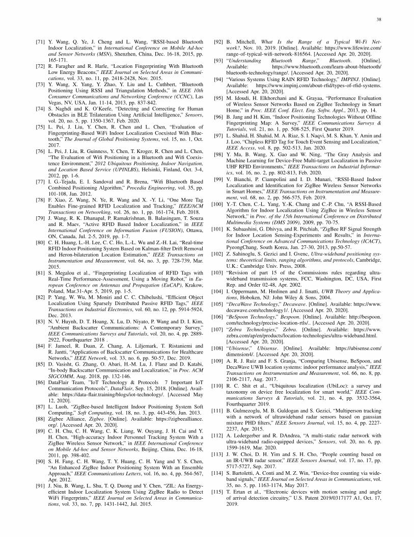
38
[71] Y. Wang, Q. Ye, J. Cheng and L. Wang, “RSSI-based BluetoothIndoor Localization,” in International Conference on Mobile Ad-hocand Sensor Networks (MSN), Shenzhen, China, Dec. 16-18, 2015, pp.165-171.
[72] R. Faragher and R. Harle, “Location Fingerprinting With BluetoothLow Energy Beacons,” IEEE Journal on Selected Areas in Communi-cations, vol. 33, no. 11, pp. 2418-2428, Nov. 2015.
[73] Y. Wang, X. Yang, Y. Zhao, Y. Liu and L. Cuthbert, “BluetoothPositioning Using RSSI and Triangulation Methods,” in IEEE 10thConsumer Communications and Networking Conference (CCNC), LasVegas, NV, USA, Jan. 11-14, 2013, pp. 837-842.
[74] S. Naghdi and K. O’Keefe, “Detecting and Correcting for HumanObstacles in BLE Trilateration Using Artificial Intelligence,” Sensors,vol. 20, no. 5, pp. 1350-1367, Feb. 2020.
[75] L. Pei, J. Liu, Y. Chen, R. Chen and L. Chen, “Evaluation ofFingerprinting-Based WiFi Indoor Localization Coexisted With Blue-tooth,” The Journal of Global Positioning Systems, vol. 15, no. 1, Oct.2017.
[76] L. Pei, J. Liu, R. Guinness, Y. Chen, T. Kroger, R. Chen and L. Chen,“The Evaluation of Wifi Positioning in a Bluetooth and Wifi Coexis-tence Environment,” 2012 Ubiquitous Positioning, Indoor Navigation,and Location Based Service (UPINLBS), Helsinki, Finland, Oct. 3-4,2012, pp. 1-6.
[77] I. G.-Tejada, E. I. Sandoval and R. Brena, “Wifi Bluetooth BasedCombined Positioning Algorithm,” Procedia Engineering, vol. 35, pp.101-108, Jan. 2012.
[78] F. Xiao, Z. Wang, N. Ye, R. Wang and X. -Y. Li, “One More TagEnables Fine-grained RFID Localization and Tracking,” IEEE/ACMTransactions on Networking, vol. 26, no. 1, pp. 161-174, Feb. 2018.
[79] J. Wang, R. K. Dhanapal, P. Ramakrishnan, B. Balasingam, T. Souzaand R. Maev, “Active RFID Based Indoor Localization,” in IEEEInternational Conference on Information Fusion (FUSION), Ottawa,ON, Canada, Jul. 2-5, 2019, pp. 1-7.
[80] C. H. Huang, L.-H. Lee, C. C. Ho, L.-L. Wu and Z.-H. Lai, “Real-timeRFID Indoor Positioning System Based on Kalman-filter Drift Removaland Heron-bilateration Location Estimation,” IEEE Transactions onInstrumentation and Measurement, vol. 64, no. 3, pp. 728-739, Mar.2015.
[81] S. Megalou et al., “Fingerprinting Localization of RFID Tags withReal-Time Performance-Assessment, Using a Moving Robot,” in Eu-ropean Conference on Antennas and Propagation (EuCAP), Krakow,Poland, Mar.31-Apr. 5, 2019, pp. 1-5.
[82] P. Yang, W. Wu, M. Moniri and C. C. Chibelushi, “Efficient ObjectLocalization Using Sparsely Distributed Passive RFID Tags,” IEEETransactions on Industrial Electronics, vol. 60, no. 12, pp. 5914-5924,Dec. 2013.
[83] N. V. Huynh, D. T. Hoang, X. Lu, D. Niyato, P. Wang and D. I. Kim,“Ambient Backscatter Communications: A Contemporary Survey,”IEEE Communications Surveys and Tutorials, vol. 20, no. 4, pp. 2889-2922, Fourthquarter 2018 .
[84] F. Jameel, R. Duan, Z. Chang, A. Liljemark, T. Ristaniemi andR. Jantti, “Applications of Backscatter Communications for HealthcareNetworks,” IEEE Network, vol. 33, no. 6, pp. 50-57, Dec. 2019.
[85] D. Vasisht, G. Zhang, O. Abari, H.-M. Lu, J. Flanz and D. Katabi,“In-body Backscatter Communication and Localization,” in Proc. ACMSIGCOMM, Aug. 2018, pp. 132-146.
[86] DataFlair Team, ”IoT Technology & Protocols 7 Important IoTCommunication Protocols”, DataFlair, Sep. 15, 2018. [Online]. Avail-able: https://data-flair.training/blogs/iot-technology/. [Accessed May12, 2020].
[87] L. Luoh, “ZigBee-based Intelligent Indoor Positioning System SoftComputing,” Soft Computing, vol. 18, no. 3, pp. 443-456, Jun. 2013.
[88] Zigbee Alliance, Zigbee. [Online]. Available: https://zigbeealliance.org/. [Accessed Apr. 20, 2020].
[89] C. H. Chu, C. H. Wang, C. K. Liang, W. Ouyang, J. H. Cai and Y.H. Chen, “High-accuracy Indoor Personnel Tracking System With aZigBee Wireless Sensor Network,” in IEEE International Conferenceon Mobile Ad-hoc and Sensor Networks, Beijing, China, Dec. 16-18,2011, pp. 398-402.
[90] S. H. Fang, C. H. Wang, T. Y. Huang, C. H. Yang and Y. S. Chen,“An Enhanced ZigBee Indoor Positioning System With an EnsembleApproach,” IEEE Communications Letters, vol. 16, no. 4, pp. 564-567,Apr. 2012.
[91] J. Niu, B. Wang, L. Shu, T. Q. Duong and Y. Chen, “ZIL: An Energy-efficient Indoor Localization System Using ZigBee Radio to DetectWiFi Fingerprints,” IEEE Journal on Selected Areas in Communica-tions, vol. 33, no. 7, pp. 1431-1442, Jul. 2015.
[92] B. Mitchell, What Is the Range of a Typical Wi-Fi Net-work?, Nov. 10, 2019. [Online]. Available: https://www.lifewire.com/range-of-typical-wifi-network-816564. [Accessed Apr. 20, 2020].
[93] “Understanding Bluetooth Range,” Bluetooth. [Online].Available: https://www.bluetooth.com/learn-about-bluetooth/bluetooth-technology/range/. [Accessed Apr. 20, 2020].
[94] “Various Systems Using RAIN RFID Technology,” IMPINJ. [Online].Available: https://www.impinj.com/about-rfid/types-of-rfid-systems.[Accessed Apr. 20, 2020].
[95] M. Idoudi, H. Elkhorchani and K. Grayaa, “Performance Evaluationof Wireless Sensor Networks Based on ZigBee Technology in SmartHome,” in Proc. IEEE Conf. Elect. Eng. Softw. Appl., 2013, pp. 14.
[96] B. Jang and H. Kim, “Indoor Positioning Technologies Without OfflineFingerprinting Map: A Survey,” IEEE Communications Surveys &Tutorials, vol. 21, no. 1, pp. 508-525, First Quarter 2019.
[97] L. Shahid, H. Shahid, M. A. Riaz, S. I. Naqvi, M. S. Khan, Y. Amin andJ. Loo, “Chipless RFID Tag for Touch Event Sensing and Localization,”IEEE Access, vol. 8, pp. 502-513, Jan. 2020.
[98] Y. Ma, B. Wang, X. Gao and W. Ning, “The Gray Analysis andMachine Learning for Device-Free Multi-target Localization in PassiveUHF RFID Environments,” IEEE Transactions on Industrial Informat-ics, vol. 16, no. 2, pp. 802-813, Feb. 2020.
[99] V. Bianchi, P. Ciampolini and I. D. Munari, “RSSI-Based IndoorLocalization and Identification for ZigBee Wireless Sensor Networksin Smart Homes,” IEEE Transactions on Instrumentation and Measure-ment, vol. 68, no. 2, pp. 566-575, Feb. 2019.
[100] Y.-T. Chen, C.-L. Yang, Y.-K. Chang and C.-P. Chu, “A RSSI-BasedAlgorithm for Indoor Localization Using ZigBee in Wireless SensorNetwork,” in Proc. of the 15th International Conference on DistributedMultimedia Systems (DMS 2009), 2009, pp. 70-75.
[101] K. Subaashini, G. Dhivya, and R. Pitchiah, “ZigBee RF Signal Strengthfor Indoor Location Sensing-Experiments and Results,” in Interna-tional Conference on Advanced Communications Technology (ICACT),PyeongChang, South Korea, Jan. 27-30, 2013, pp.50-57.
[102] Z. Sahinoglu, S. Gezici and I. Gvenc, Ultra-wideband positioning sys-tems: theoretical limits, ranging algorithms, and protocols, Cambridge,U.K.: Cambridge Univ. Press, 2008.
[103] “Revision of part 15 of the Commissions rules regarding ultra-wideband transmission systems, FCC, Washington, DC, USA, FirstRep. and Order 02-48, Apr. 2002.
[104] I. Oppermann, M. Hmlinen and J. Iinatti, UWB Theory and Applica-tions, Hoboken, NJ: John Wiley & Sons, 2004.
[105] “DecaWave Technology,” Decawave. [Online]. Available: https://www.decawave.com/technology1/. [Accessed Apr. 20, 2020].
[106] “BeSpoon Technology,” Bespoon. [Online]. Available: http://bespoon.com/technology/precise-location-rtls/.. [Accessed Apr. 20, 2020].
[107] “Zebra Technologies,” Zebra. [Online]. Available: https://www.zebra.com/ap/en/products/location-technologies/ultra-wideband.html.[Accessed Apr. 20, 2020].
[108] “Ubisense,” Ubisense. [Online]. Available: https://ubisense.com/dimension4/. [Accessed Apr. 20, 2020].
[109] A. R. J. Ruiz and F. S. Granja, “Comparing Ubisense, BeSpoon, andDecaWave UWB location systems: indoor performance analysis,” IEEETransactions on Instrumentation and Measurement, vol. 66, no. 8, pp.2106-2117, Aug. 2017.
[110] R. C. Shit et al., “Ubiquitous localization (UbiLoc): a survey andtaxonomy on device free localization for smart world,” IEEE Com-munications Surveys & Tutorials, vol. 21, no. 4, pp. 3532-3564,Fourthquarter 2019.
[111] B. Gulmezoglu, M. B. Guldogan and S. Gezici, “Multiperson trackingwith a network of ultrawideband radar sensors based on gaussianmixture PHD filters,” IEEE Sensors Journal, vol. 15, no. 4, pp. 2227-2237, Apr. 2015.
[112] A. Ledergerber and R. DAndrea, “A multi-static radar network withultra-wideband radio-equipped devices,” Sensors, vol. 20, no. 6, pp.1599-1619, Mar. 2020.
[113] J. W. Choi, D. H. Yim and S. H. Cho, “People counting based onan IR-UWB radar sensor,” IEEE Sensors Journal, vol. 17, no. 17, pp.5717-5727, Sep. 2017.
[114] S. Bartoletti, A. Conti and M. Z. Win, “Device-free counting via wide-band signals,” IEEE Journal on Selected Areas in Communications, vol.35, no. 5, pp. 1163-1174, May 2017.
[115] T. Ertan et al., “Electronic devices with motion sensing and angleof arrival detection circuitry,” U.S. Patent 2019/0317177 A1, Oct. 17,2019.
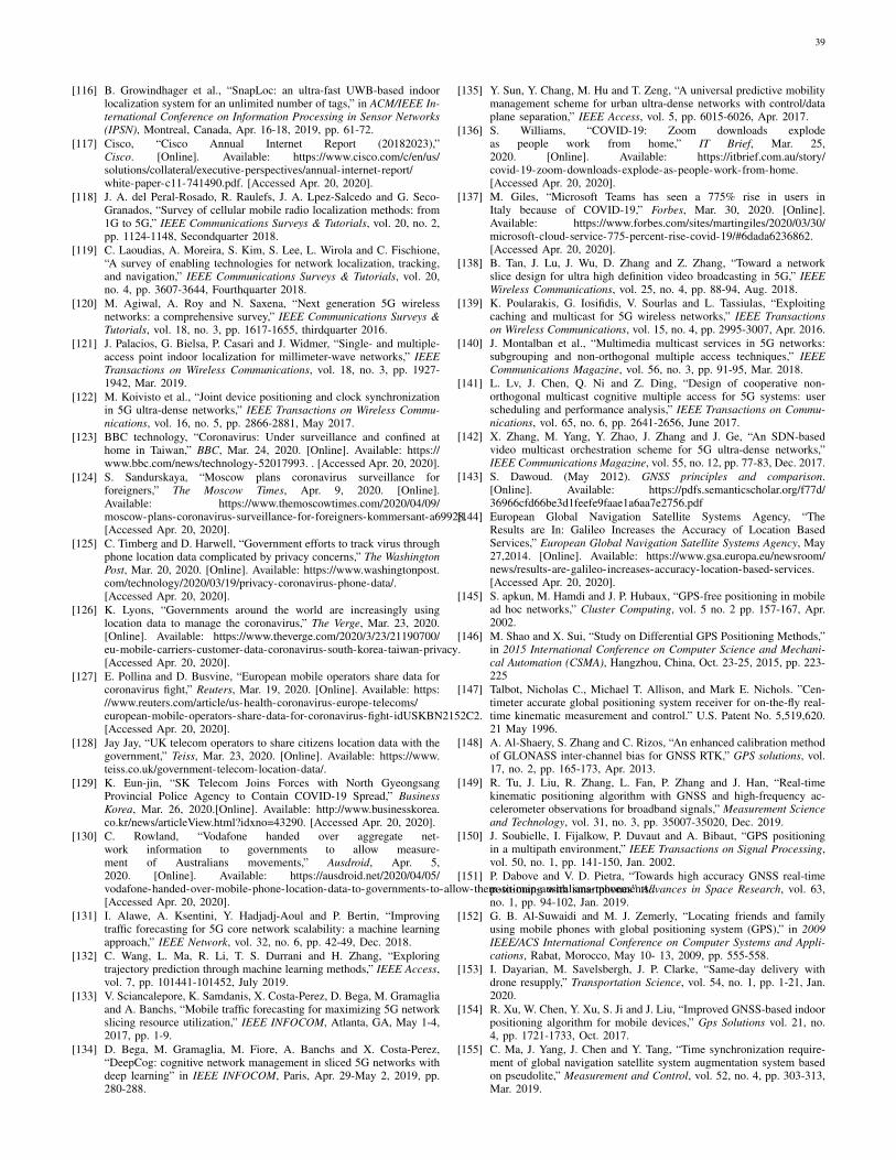
39
[116] B. Growindhager et al., “SnapLoc: an ultra-fast UWB-based indoorlocalization system for an unlimited number of tags,” in ACM/IEEE In-ternational Conference on Information Processing in Sensor Networks(IPSN), Montreal, Canada, Apr. 16-18, 2019, pp. 61-72.
[117] Cisco, “Cisco Annual Internet Report (20182023),”Cisco. [Online]. Available: https://www.cisco.com/c/en/us/solutions/collateral/executive-perspectives/annual-internet-report/white-paper-c11-741490.pdf. [Accessed Apr. 20, 2020].
[118] J. A. del Peral-Rosado, R. Raulefs, J. A. Lpez-Salcedo and G. Seco-Granados, “Survey of cellular mobile radio localization methods: from1G to 5G,” IEEE Communications Surveys & Tutorials, vol. 20, no. 2,pp. 1124-1148, Secondquarter 2018.
[119] C. Laoudias, A. Moreira, S. Kim, S. Lee, L. Wirola and C. Fischione,“A survey of enabling technologies for network localization, tracking,and navigation,” IEEE Communications Surveys & Tutorials, vol. 20,no. 4, pp. 3607-3644, Fourthquarter 2018.
[120] M. Agiwal, A. Roy and N. Saxena, “Next generation 5G wirelessnetworks: a comprehensive survey,” IEEE Communications Surveys &Tutorials, vol. 18, no. 3, pp. 1617-1655, thirdquarter 2016.
[121] J. Palacios, G. Bielsa, P. Casari and J. Widmer, “Single- and multiple-access point indoor localization for millimeter-wave networks,” IEEETransactions on Wireless Communications, vol. 18, no. 3, pp. 1927-1942, Mar. 2019.
[122] M. Koivisto et al., “Joint device positioning and clock synchronizationin 5G ultra-dense networks,” IEEE Transactions on Wireless Commu-nications, vol. 16, no. 5, pp. 2866-2881, May 2017.
[123] BBC technology, “Coronavirus: Under surveillance and confined athome in Taiwan,” BBC, Mar. 24, 2020. [Online]. Available: https://www.bbc.com/news/technology-52017993. . [Accessed Apr. 20, 2020].
[124] S. Sandurskaya, “Moscow plans coronavirus surveillance forforeigners,” The Moscow Times, Apr. 9, 2020. [Online].Available: https://www.themoscowtimes.com/2020/04/09/moscow-plans-coronavirus-surveillance-for-foreigners-kommersant-a69928.[Accessed Apr. 20, 2020].
[125] C. Timberg and D. Harwell, “Government efforts to track virus throughphone location data complicated by privacy concerns,” The WashingtonPost, Mar. 20, 2020. [Online]. Available: https://www.washingtonpost.com/technology/2020/03/19/privacy-coronavirus-phone-data/.[Accessed Apr. 20, 2020].
[126] K. Lyons, “Governments around the world are increasingly usinglocation data to manage the coronavirus,” The Verge, Mar. 23, 2020.[Online]. Available: https://www.theverge.com/2020/3/23/21190700/eu-mobile-carriers-customer-data-coronavirus-south-korea-taiwan-privacy.[Accessed Apr. 20, 2020].
[127] E. Pollina and D. Busvine, “European mobile operators share data forcoronavirus fight,” Reuters, Mar. 19, 2020. [Online]. Available: https://www.reuters.com/article/us-health-coronavirus-europe-telecoms/european-mobile-operators-share-data-for-coronavirus-fight-idUSKBN2152C2.[Accessed Apr. 20, 2020].
[128] Jay Jay, “UK telecom operators to share citizens location data with thegovernment,” Teiss, Mar. 23, 2020. [Online]. Available: https://www.teiss.co.uk/government-telecom-location-data/.
[129] K. Eun-jin, “SK Telecom Joins Forces with North GyeongsangProvincial Police Agency to Contain COVID-19 Spread,” BusinessKorea, Mar. 26, 2020.[Online]. Available: http://www.businesskorea.co.kr/news/articleView.html?idxno=43290. [Accessed Apr. 20, 2020].
[130] C. Rowland, “Vodafone handed over aggregate net-work information to governments to allow measure-ment of Australians movements,” Ausdroid, Apr. 5,2020. [Online]. Available: https://ausdroid.net/2020/04/05/vodafone-handed-over-mobile-phone-location-data-to-governments-to-allow-them-to-map-australians-movements/.[Accessed Apr. 20, 2020].
[131] I. Alawe, A. Ksentini, Y. Hadjadj-Aoul and P. Bertin, “Improvingtraffic forecasting for 5G core network scalability: a machine learningapproach,” IEEE Network, vol. 32, no. 6, pp. 42-49, Dec. 2018.
[132] C. Wang, L. Ma, R. Li, T. S. Durrani and H. Zhang, “Exploringtrajectory prediction through machine learning methods,” IEEE Access,vol. 7, pp. 101441-101452, July 2019.
[133] V. Sciancalepore, K. Samdanis, X. Costa-Perez, D. Bega, M. Gramagliaand A. Banchs, “Mobile traffic forecasting for maximizing 5G networkslicing resource utilization,” IEEE INFOCOM, Atlanta, GA, May 1-4,2017, pp. 1-9.
[134] D. Bega, M. Gramaglia, M. Fiore, A. Banchs and X. Costa-Perez,“DeepCog: cognitive network management in sliced 5G networks withdeep learning” in IEEE INFOCOM, Paris, Apr. 29-May 2, 2019, pp.280-288.
[135] Y. Sun, Y. Chang, M. Hu and T. Zeng, “A universal predictive mobilitymanagement scheme for urban ultra-dense networks with control/dataplane separation,” IEEE Access, vol. 5, pp. 6015-6026, Apr. 2017.
[136] S. Williams, “COVID-19: Zoom downloads explodeas people work from home,” IT Brief, Mar. 25,2020. [Online]. Available: https://itbrief.com.au/story/covid-19-zoom-downloads-explode-as-people-work-from-home.[Accessed Apr. 20, 2020].
[137] M. Giles, “Microsoft Teams has seen a 775% rise in users inItaly because of COVID-19,” Forbes, Mar. 30, 2020. [Online].Available: https://www.forbes.com/sites/martingiles/2020/03/30/microsoft-cloud-service-775-percent-rise-covid-19/#6dada6236862.[Accessed Apr. 20, 2020].
[138] B. Tan, J. Lu, J. Wu, D. Zhang and Z. Zhang, “Toward a networkslice design for ultra high definition video broadcasting in 5G,” IEEEWireless Communications, vol. 25, no. 4, pp. 88-94, Aug. 2018.
[139] K. Poularakis, G. Iosifidis, V. Sourlas and L. Tassiulas, “Exploitingcaching and multicast for 5G wireless networks,” IEEE Transactionson Wireless Communications, vol. 15, no. 4, pp. 2995-3007, Apr. 2016.
[140] J. Montalban et al., “Multimedia multicast services in 5G networks:subgrouping and non-orthogonal multiple access techniques,” IEEECommunications Magazine, vol. 56, no. 3, pp. 91-95, Mar. 2018.
[141] L. Lv, J. Chen, Q. Ni and Z. Ding, “Design of cooperative non-orthogonal multicast cognitive multiple access for 5G systems: userscheduling and performance analysis,” IEEE Transactions on Commu-nications, vol. 65, no. 6, pp. 2641-2656, June 2017.
[142] X. Zhang, M. Yang, Y. Zhao, J. Zhang and J. Ge, “An SDN-basedvideo multicast orchestration scheme for 5G ultra-dense networks,”IEEE Communications Magazine, vol. 55, no. 12, pp. 77-83, Dec. 2017.
[143] S. Dawoud. (May 2012). GNSS principles and comparison.[Online]. Available: https://pdfs.semanticscholar.org/f77d/36966cfd66be3d1feefe9faae1a6aa7e2756.pdf
[144] European Global Navigation Satellite Systems Agency, “TheResults are In: Galileo Increases the Accuracy of Location BasedServices,” European Global Navigation Satellite Systems Agency, May27,2014. [Online]. Available: https://www.gsa.europa.eu/newsroom/news/results-are-galileo-increases-accuracy-location-based-services.[Accessed Apr. 20, 2020].
[145] S. apkun, M. Hamdi and J. P. Hubaux, “GPS-free positioning in mobilead hoc networks,” Cluster Computing, vol. 5 no. 2 pp. 157-167, Apr.2002.
[146] M. Shao and X. Sui, “Study on Differential GPS Positioning Methods,”in 2015 International Conference on Computer Science and Mechani-cal Automation (CSMA), Hangzhou, China, Oct. 23-25, 2015, pp. 223-225
[147] Talbot, Nicholas C., Michael T. Allison, and Mark E. Nichols. ”Cen-timeter accurate global positioning system receiver for on-the-fly real-time kinematic measurement and control.” U.S. Patent No. 5,519,620.21 May 1996.
[148] A. Al-Shaery, S. Zhang and C. Rizos, “An enhanced calibration methodof GLONASS inter-channel bias for GNSS RTK,” GPS solutions, vol.17, no. 2, pp. 165-173, Apr. 2013.
[149] R. Tu, J. Liu, R. Zhang, L. Fan, P. Zhang and J. Han, “Real-timekinematic positioning algorithm with GNSS and high-frequency ac-celerometer observations for broadband signals,” Measurement Scienceand Technology, vol. 31, no. 3, pp. 35007-35020, Dec. 2019.
[150] J. Soubielle, I. Fijalkow, P. Duvaut and A. Bibaut, “GPS positioningin a multipath environment,” IEEE Transactions on Signal Processing,vol. 50, no. 1, pp. 141-150, Jan. 2002.
[151] P. Dabove and V. D. Pietra, “Towards high accuracy GNSS real-timepositioning with smartphones” Advances in Space Research, vol. 63,no. 1, pp. 94-102, Jan. 2019.
[152] G. B. Al-Suwaidi and M. J. Zemerly, “Locating friends and familyusing mobile phones with global positioning system (GPS),” in 2009IEEE/ACS International Conference on Computer Systems and Appli-cations, Rabat, Morocco, May 10- 13, 2009, pp. 555-558.
[153] I. Dayarian, M. Savelsbergh, J. P. Clarke, “Same-day delivery withdrone resupply,” Transportation Science, vol. 54, no. 1, pp. 1-21, Jan.2020.
[154] R. Xu, W. Chen, Y. Xu, S. Ji and J. Liu, “Improved GNSS-based indoorpositioning algorithm for mobile devices,” Gps Solutions vol. 21, no.4, pp. 1721-1733, Oct. 2017.
[155] C. Ma, J. Yang, J. Chen and Y. Tang, “Time synchronization require-ment of global navigation satellite system augmentation system basedon pseudolite,” Measurement and Control, vol. 52, no. 4, pp. 303-313,Mar. 2019.
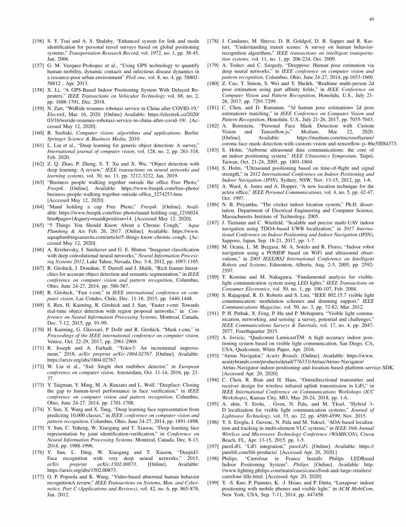
40
[156] S. Y. Tsui and A. S. Shalaby, “Enhanced system for link and modeidentification for personal travel surveys based on global positioningsystems,” Transportation Research Record, vol. 1972, no. 1, pp. 38-45,Jan. 2006.
[157] G. M. Vazquez-Prokopec et al., “Using GPS technology to quantifyhuman mobility, dynamic contacts and infectious disease dynamics ina resource-poor urban environment” PloS one, vol. 8, no. 4, pp. 58802-58812 , Apr. 2013.
[158] X. Li, “A GPS-Based Indoor Positioning System With Delayed Re-peaters,” IEEE Transactions on Vehicular Technology vol. 68, no. 2,pp. 1688-1701, Dec. 2018.
[159] N. Zart, “WeRide resumes robotaxi service in China after COVID-19,”Electrek, Mar. 16, 2020. [Online] Available: https://electrek.co/2020/03/16/weride-resumes-robotaxi-service-in-china-after-covid-19/. [Ac-cessed May 12, 2020].
[160] R. Szeliski, Computer vision: algorithms and applications. Berlin:Springer Science & Business Media, 2010.
[161] L. Liu et al., “Deep learning for generic object detection: A survey,”International journal of computer vision, vol. 128, no. 2, pp. 261-318,Feb. 2020.
[162] Z. Q. Zhao, P. Zheng, S. T. Xu and X. Wu, “Object detection withdeep learning: A review,” IEEE transactions on neural networks andlearning systems, vol. 30, no. 11, pp. 3212-3232, Jan. 2019.
[163] “Business people walking together outside the office Free Photo,”Freepik. [Online]. Available: https://www.freepik.com/free-photo/business-people-walking-together-outside-office 3274253.htm.[Accessed May 12, 2020].
[164] “Mand holding a cup Free Photo,” Freepik. [Online]. Avail-able: https://www.freepik.com/free-photo/mand-holding-cup 1216024.htm#page=1&query=man&position=14. [Accessed May 12, 2020].
[165] “5 Things You Should Know About a Chronic Cough,” AquaPlumbing & Air, Feb. 26, 2017. [Online]. Available: https://www.aquaplumbingsarasota.com/article/5-things-know-chronic-cough. [Ac-cessed May 12, 2020].
[166] A. Krizhevsky, I. Sutskever and G. E. Hinton “Imagenet classificationwith deep convolutional neural networks,” Neural Information Process-ing Systems 2012, Lake Tahoe, Nevada, Dec. 3-8, 2012, pp. 1097-1105.
[167] R. Girshick, J. Donahue, T. Darrell and J. Malik, “Rich feature hierar-chies for accurate object detection and semantic segmentation,” in IEEEconference on computer vision and pattern recognition, Columbus,Ohio, June 24-27, 2014, pp. 580-587.
[168] R. Girshick, “Fast r-cnn,” in IEEE international conference on com-puter vision, Las Condes, Chile, Dec. 11-18, 2015, pp. 1440-1448.
[169] S. Ren, H. Kaiming, R. Girshick and J. Sun, “Faster r-cnn: Towardsreal-time object detection with region proposal networks,” in Con-ference on Neural Information Processing Systems, Montreal, Canada,Dec. 7-12, 2015, pp. 91-99.
[170] H. Kaiming, G. Gkioxari, P. Dollr and R. Girshick, “Mask r-cnn,” inProceedings of the IEEE international conference on computer vision,Venice, Oct. 22-29, 2017, pp. 2961-2969.
[171] R. Joseph and A. Farhadi. “Yolov3: An incremental improve-ment,” 2018, arXiv preprint arXiv:1804.02767. [Online]. Available:https://arxiv.org/abs/1804.02767.
[172] W. Liu et al., “Ssd: Single shot multibox detector,” in Europeanconference on computer vision, Amsterdam, Oct. 11-14, 2016, pp. 21-37.
[173] Y. Taigman, Y. Ming, M. A. Ranzato and L. Wolf, “Deepface: Closingthe gap to human-level performance in face verification,” in IEEEconference on computer vision and pattern recognition, Columbus,Ohio, June 24-27, 2014, pp. 1701-1708.
[174] Y. Sun, X. Wang and X. Tang, “Deep learning face representation frompredicting 10,000 classes,” in IEEE conference on computer vision andpattern recognition, Columbus, Ohio, June 24-27, 2014, pp. 1891-1898.
[175] Y. Sun, C. Yuheng, W. Xiaogang and T. Xiaoou, “Deep learning facerepresentation by joint identification-verification,” in Conference onNeural Information Processing Systems, Montreal, Canada, Dec. 8-13,2014, pp. 1988-1996.
[176] Y. Sun, L. Ding, W. Xiaogang and T. Xiaoou, “Deepid3:Face recognition with very deep neural networks,” 2015,arXiv preprint arXiv:1502.00873. [Online]. Available:https://arxiv.org/abs/1502.00873.
[177] O. P. Popoola and K. Wang, “Video-based abnormal human behaviorrecognitionA review,” IEEE Transactions on Systems, Man, and Cyber-netics, Part C (Applications and Reviews), vol. 42, no. 6, pp. 865-878,Jan. 2012.
[178] J. Candamo, M. Shreve, D. B. Goldgof, D. B. Sapper and R. Kas-turi, “Understanding transit scenes: A survey on human behavior-recognition algorithms,” IEEE transactions on intelligent transporta-tion systems, vol. 11, no. 1, pp. 206-224, Oct. 2009.
[179] A. Toshev and C. Szegedy, “Deeppose: Human pose estimation viadeep neural networks,” in IEEE conference on computer vision andpattern recognition, Columbus, Ohio, June 24-27, 2014, pp.1653-1660.
[180] Z. Cao, T. Simon, S. Wei and Y. Sheikh, “Realtime multi-person 2dpose estimation using part affinity fields,” in IEEE Conference onComputer Vision and Pattern Recognition, Honolulu, U.S., July 21-26, 2017, pp. 7291-7299.
[181] C. Chen, and D. Ramanan, “3d human pose estimation= 2d poseestimation+ matching,” in IEEE Conference on Computer Vision andPattern Recognition, Honolulu, U.S., July 21-26, 2017, pp. 7035-7043.
[182] A. Bornstein, “Personal Face Mask Detection with CustomVision and Tensorflow.js,” Medium, Mar. 22, 2020.[Online]. Available: https://medium.com/microsoftazure/corona-face-mask-detection-with-custom-vision-and-tensorflow-js-86e5fff84373.
[183] S. Holm, “Airborne ultrasound data communications: the core ofan indoor positioning system,” IEEE Ultrasonics Symposium, Taipei,Taiwan, Oct. 21-24, 2005, pp. 1801-1804.
[184] S. Holm, “Ultrasound positioning based on time-of-flight and signalstrength,” in 2012 International Conference on Indoor Positioning andIndoor Navigation (IPIN), Sydney, NSW, Nov. 13-15, 2012, pp. 1-6.
[185] A. Ward, A. Jones and A. Hopper, “A new location technique for theactive office,” IEEE Personal Communications, vol. 4, no. 5, pp. 42-47,Oct. 1997.
[186] N. B. Priyantha, “The cricket indoor location system,” Ph.D. disser-tation. Department of Electrical Engineering and Computer Science,Massachusetts Institute of Technology, 2005.
[187] J. Tiemann and C. Wietfeld, “Scalable and precise multi-UAV indoornavigation using TDOA-based UWB localization,” in 2017 Interna-tional Conference on Indoor Positioning and Indoor Navigation (IPIN),Sapporo, Japan, Sep. 18-21, 2017, pp. 1-7.
[188] M. Ocana, L. M. Bergasa, M. A. Sotelo and R. Flores, “Indoor robotnavigation using a POMDP based on WiFi and ultrasound obser-vations,” in 2005 IEEE/RSJ International Conference on IntelligentRobots and Systems, Edmonton, Alberta, Aug. 2-5, 2005, pp. 2592-2597.
[189] T. Komine and M. Nakagawa, “Fundamental analysis for visible-light communication system using LED lights,” IEEE Transactions onConsumer Electronics, vol. 50, no. 1, pp. 100-107, Feb. 2004.
[190] S. Rajagopal, R. D. Roberts and S. Lim, “IEEE 802.15.7 visible lightcommunication: modulation schemes and dimming support,” IEEECommunications Magazine, vol. 50, no. 3, pp. 72-82, Mar. 2012.
[191] P. H. Pathak, X. Feng, P. Hu and P. Mohapatra, “Visible light commu-nication, networking, and sensing: a survey, potential and challenges,”IEEE Communications Surveys & Tutorials, vol. 17, no. 4, pp. 2047-2077, Fourthquarter 2015.
[192] A. Jovicic, “Qualcomm LumicastTM: A high accuracy indoor posi-tioning system based on visible light communication, San Diego, CA,USA, Qualcomm, White Paper, Apr. 2016.
[193] “Atrius Navigator,” Acuity Brands. [Online]. Available: https://www.acuitybrands.com/products/detail/776333/Atrius/Atrius-Navigator/Atrius-Navigator-indoor-positioning-and-location-based-platform-service-SDK.[Accessed Apr. 20, 2020]
[194] C. Chen, R. Bian and H. Haas, “Omnidirectional transmitter andreceiver design for wireless infrared uplink transmission in LiFi,” inIEEE International Conference on Communications Workshops (ICCWorkshops), Kansas City, MO, May 20-24, 2018, pp. 1-6.
[195] A. ahin, Y. Erolu, . Gven, N. Pala, and M. Yksel, “Hybrid 3-D localization for visible light communication systems,” Journal ofLightwave Technology, vol. 33, no. 22, pp. 4589-4599, Nov. 2015.
[196] Y. S. Eroglu, I. Guvenc, N. Pala and M. Yuksel, “AOA-based localiza-tion and tracking in multi-element VLC systems,” in IEEE 16th AnnualWireless and Microwave Technology Conference (WAMICON), CocoaBeach, FL, Apr. 13-15, 2015, pp. 1-5.
[197] pureLiFi, “LiFi integration,” pureLiFi. [Online]. Available: https://purelifi.com/lifi-products/. [Accessed Apr. 20, 2020.]
[198] Philips, “Carrefour in France Installs Philips LEDBasedIndoor Positioning System”, Philips. [Online]. Available: http://www.lighting.philips.com/main/cases/cases/food-and-large-retailers/carrefour-lille.html. [Accessed Apr. 20, 2020]
[199] Y. -S. Kuo, P. Pannuto, K. -J. Hsiao, and P. Dutta, “Luxapose: indoorpositioning with mobile phones and visible light,” in ACM MobiCom,New York, USA, Sep. 7-11, 2014, pp. 447458.
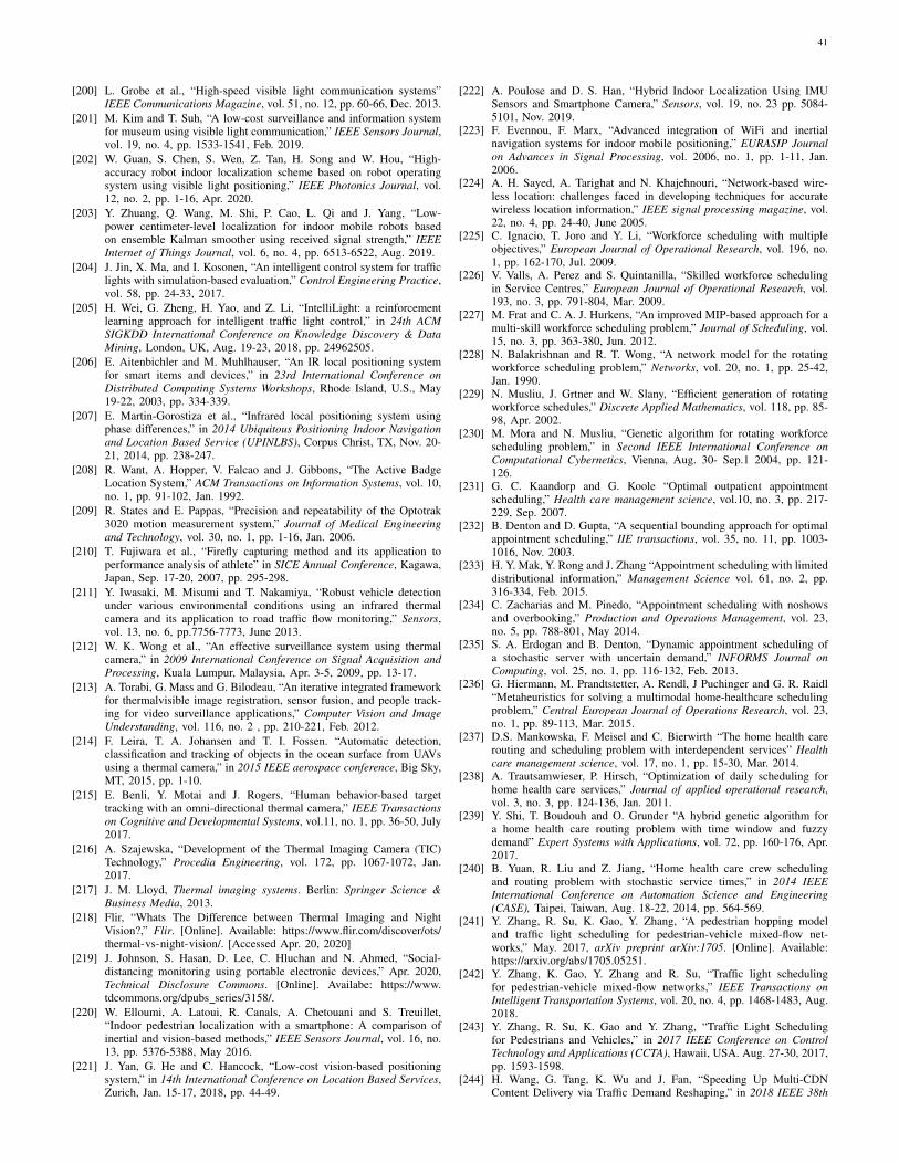
41
[200] L. Grobe et al., “High-speed visible light communication systems”IEEE Communications Magazine, vol. 51, no. 12, pp. 60-66, Dec. 2013.
[201] M. Kim and T. Suh, “A low-cost surveillance and information systemfor museum using visible light communication,” IEEE Sensors Journal,vol. 19, no. 4, pp. 1533-1541, Feb. 2019.
[202] W. Guan, S. Chen, S. Wen, Z. Tan, H. Song and W. Hou, “High-accuracy robot indoor localization scheme based on robot operatingsystem using visible light positioning,” IEEE Photonics Journal, vol.12, no. 2, pp. 1-16, Apr. 2020.
[203] Y. Zhuang, Q. Wang, M. Shi, P. Cao, L. Qi and J. Yang, “Low-power centimeter-level localization for indoor mobile robots basedon ensemble Kalman smoother using received signal strength,” IEEEInternet of Things Journal, vol. 6, no. 4, pp. 6513-6522, Aug. 2019.
[204] J. Jin, X. Ma, and I. Kosonen, “An intelligent control system for trafficlights with simulation-based evaluation,” Control Engineering Practice,vol. 58, pp. 24-33, 2017.
[205] H. Wei, G. Zheng, H. Yao, and Z. Li, “IntelliLight: a reinforcementlearning approach for intelligent traffic light control,” in 24th ACMSIGKDD International Conference on Knowledge Discovery & DataMining, London, UK, Aug. 19-23, 2018, pp. 24962505.
[206] E. Aitenbichler and M. Muhlhauser, “An IR local positioning systemfor smart items and devices,” in 23rd International Conference onDistributed Computing Systems Workshops, Rhode Island, U.S., May19-22, 2003, pp. 334-339.
[207] E. Martin-Gorostiza et al., “Infrared local positioning system usingphase differences,” in 2014 Ubiquitous Positioning Indoor Navigationand Location Based Service (UPINLBS), Corpus Christ, TX, Nov. 20-21, 2014, pp. 238-247.
[208] R. Want, A. Hopper, V. Falcao and J. Gibbons, “The Active BadgeLocation System,” ACM Transactions on Information Systems, vol. 10,no. 1, pp. 91-102, Jan. 1992.
[209] R. States and E. Pappas, “Precision and repeatability of the Optotrak3020 motion measurement system,” Journal of Medical Engineeringand Technology, vol. 30, no. 1, pp. 1-16, Jan. 2006.
[210] T. Fujiwara et al., “Firefly capturing method and its application toperformance analysis of athlete” in SICE Annual Conference, Kagawa,Japan, Sep. 17-20, 2007, pp. 295-298.
[211] Y. Iwasaki, M. Misumi and T. Nakamiya, “Robust vehicle detectionunder various environmental conditions using an infrared thermalcamera and its application to road traffic flow monitoring,” Sensors,vol. 13, no. 6, pp.7756-7773, June 2013.
[212] W. K. Wong et al., “An effective surveillance system using thermalcamera,” in 2009 International Conference on Signal Acquisition andProcessing, Kuala Lumpur, Malaysia, Apr. 3-5, 2009, pp. 13-17.
[213] A. Torabi, G. Mass and G. Bilodeau, “An iterative integrated frameworkfor thermalvisible image registration, sensor fusion, and people track-ing for video surveillance applications,” Computer Vision and ImageUnderstanding, vol. 116, no. 2 , pp. 210-221, Feb. 2012.
[214] F. Leira, T. A. Johansen and T. I. Fossen. “Automatic detection,classification and tracking of objects in the ocean surface from UAVsusing a thermal camera,” in 2015 IEEE aerospace conference, Big Sky,MT, 2015, pp. 1-10.
[215] E. Benli, Y. Motai and J. Rogers, “Human behavior-based targettracking with an omni-directional thermal camera,” IEEE Transactionson Cognitive and Developmental Systems, vol.11, no. 1, pp. 36-50, July2017.
[216] A. Szajewska, “Development of the Thermal Imaging Camera (TIC)Technology,” Procedia Engineering, vol. 172, pp. 1067-1072, Jan.2017.
[217] J. M. Lloyd, Thermal imaging systems. Berlin: Springer Science &Business Media, 2013.
[218] Flir, “Whats The Difference between Thermal Imaging and NightVision?,” Flir. [Online]. Available: https://www.flir.com/discover/ots/thermal-vs-night-vision/. [Accessed Apr. 20, 2020]
[219] J. Johnson, S. Hasan, D. Lee, C. Hluchan and N. Ahmed, “Social-distancing monitoring using portable electronic devices,” Apr. 2020,Technical Disclosure Commons. [Online]. Availabe: https://www.tdcommons.org/dpubs series/3158/.
[220] W. Elloumi, A. Latoui, R. Canals, A. Chetouani and S. Treuillet,“Indoor pedestrian localization with a smartphone: A comparison ofinertial and vision-based methods,” IEEE Sensors Journal, vol. 16, no.13, pp. 5376-5388, May 2016.
[221] J. Yan, G. He and C. Hancock, “Low-cost vision-based positioningsystem,” in 14th International Conference on Location Based Services,Zurich, Jan. 15-17, 2018, pp. 44-49.
[222] A. Poulose and D. S. Han, “Hybrid Indoor Localization Using IMUSensors and Smartphone Camera,” Sensors, vol. 19, no. 23 pp. 5084-5101, Nov. 2019.
[223] F. Evennou, F. Marx, “Advanced integration of WiFi and inertialnavigation systems for indoor mobile positioning,” EURASIP Journalon Advances in Signal Processing, vol. 2006, no. 1, pp. 1-11, Jan.2006.
[224] A. H. Sayed, A. Tarighat and N. Khajehnouri, “Network-based wire-less location: challenges faced in developing techniques for accuratewireless location information,” IEEE signal processing magazine, vol.22, no. 4, pp. 24-40, June 2005.
[225] C. Ignacio, T. Joro and Y. Li, “Workforce scheduling with multipleobjectives,” European Journal of Operational Research, vol. 196, no.1, pp. 162-170, Jul. 2009.
[226] V. Valls, A. Perez and S. Quintanilla, “Skilled workforce schedulingin Service Centres,” European Journal of Operational Research, vol.193, no. 3, pp. 791-804, Mar. 2009.
[227] M. Frat and C. A. J. Hurkens, “An improved MIP-based approach for amulti-skill workforce scheduling problem,” Journal of Scheduling, vol.15, no. 3, pp. 363-380, Jun. 2012.
[228] N. Balakrishnan and R. T. Wong, “A network model for the rotatingworkforce scheduling problem,” Networks, vol. 20, no. 1, pp. 25-42,Jan. 1990.
[229] N. Musliu, J. Grtner and W. Slany, “Efficient generation of rotatingworkforce schedules,” Discrete Applied Mathematics, vol. 118, pp. 85-98, Apr. 2002.
[230] M. Mora and N. Musliu, “Genetic algorithm for rotating workforcescheduling problem,” in Second IEEE International Conference onComputational Cybernetics, Vienna, Aug. 30- Sep.1 2004, pp. 121-126.
[231] G. C. Kaandorp and G. Koole “Optimal outpatient appointmentscheduling,” Health care management science, vol.10, no. 3, pp. 217-229, Sep. 2007.
[232] B. Denton and D. Gupta, “A sequential bounding approach for optimalappointment scheduling,” IIE transactions, vol. 35, no. 11, pp. 1003-1016, Nov. 2003.
[233] H. Y. Mak, Y. Rong and J. Zhang “Appointment scheduling with limiteddistributional information,” Management Science vol. 61, no. 2, pp.316-334, Feb. 2015.
[234] C. Zacharias and M. Pinedo, “Appointment scheduling with noshowsand overbooking,” Production and Operations Management, vol. 23,no. 5, pp. 788-801, May 2014.
[235] S. A. Erdogan and B. Denton, “Dynamic appointment scheduling ofa stochastic server with uncertain demand,” INFORMS Journal onComputing, vol. 25, no. 1, pp. 116-132, Feb. 2013.
[236] G. Hiermann, M. Prandtstetter, A. Rendl, J Puchinger and G. R. Raidl“Metaheuristics for solving a multimodal home-healthcare schedulingproblem,” Central European Journal of Operations Research, vol. 23,no. 1, pp. 89-113, Mar. 2015.
[237] D.S. Mankowska, F. Meisel and C. Bierwirth “The home health carerouting and scheduling problem with interdependent services” Healthcare management science, vol. 17, no. 1, pp. 15-30, Mar. 2014.
[238] A. Trautsamwieser, P. Hirsch, “Optimization of daily scheduling forhome health care services,” Journal of applied operational research,vol. 3, no. 3, pp. 124-136, Jan. 2011.
[239] Y. Shi, T. Boudouh and O. Grunder “A hybrid genetic algorithm fora home health care routing problem with time window and fuzzydemand” Expert Systems with Applications, vol. 72, pp. 160-176, Apr.2017.
[240] B. Yuan, R. Liu and Z. Jiang, “Home health care crew schedulingand routing problem with stochastic service times,” in 2014 IEEEInternational Conference on Automation Science and Engineering(CASE), Taipei, Taiwan, Aug. 18-22, 2014, pp. 564-569.
[241] Y. Zhang, R. Su, K. Gao, Y. Zhang, “A pedestrian hopping modeland traffic light scheduling for pedestrian-vehicle mixed-flow net-works,” May. 2017, arXiv preprint arXiv:1705. [Online]. Available:https://arxiv.org/abs/1705.05251.
[242] Y. Zhang, K. Gao, Y. Zhang and R. Su, “Traffic light schedulingfor pedestrian-vehicle mixed-flow networks,” IEEE Transactions onIntelligent Transportation Systems, vol. 20, no. 4, pp. 1468-1483, Aug.2018.
[243] Y. Zhang, R. Su, K. Gao and Y. Zhang, “Traffic Light Schedulingfor Pedestrians and Vehicles,” in 2017 IEEE Conference on ControlTechnology and Applications (CCTA), Hawaii, USA. Aug. 27-30, 2017,pp. 1593-1598.
[244] H. Wang, G. Tang, K. Wu and J. Fan, “Speeding Up Multi-CDNContent Delivery via Traffic Demand Reshaping,” in 2018 IEEE 38th
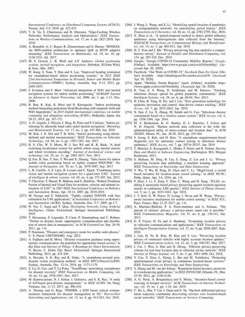
42
International Conference on Distributed Computing Systems (ICDCS),Vienna, July 2-5, 2018, pp. 422-433.
[245] T. X. Vu, S. Chatzinotas and B. Ottersten, “Edge-Caching WirelessNetworks: Performance Analysis and Optimization,” IEEE Transac-tions on Wireless Communications, vol. 17, no. 4, pp. 2827-2839, Apr.2018.
[246] A. Bentaleb, A. C. Begen, R. Zimmermann and S. Harous “SDNHAS:An SDN-enabled architecture to optimize QoE in HTTP adaptivestreaming,” IEEE Transactions on Multimedia, vol. 19, no. 10, pp.2136-2151, Jul. 2017.
[247] M. S. Grewal, L. R. Weill and A.P. Andrews. Global positioningsystems, inertial navigation, and integration. Hoboken, NJ:John Wiley& Sons, Mar. 2007.
[248] W. Kang, S. Nam, Y. Han and S. Lee, “Improved heading estimationfor smartphone-based indoor positioning systems,” in 2012 IEEE23rd International Symposium on Personal, Indoor and Mobile RadioCommunications-(PIMRC), Sydney, Australia, Sep. 9-12, 2012, pp.2449-2453.
[249] F. Evennou and F. Marx “Advanced integration of WiFi and inertialnavigation systems for indoor mobile positioning,” EURASIP Journalon Advances in Signal Processing, vol. 2006, no. 1, pp. 1-11, Dec.2006.
[250] R. Ban, K. Kaji, K. Hiroi and N. Kawaguchi, “Indoor positioningmethod integrating pedestrian Dead Reckoning with magnetic field andWiFi fingerprints,” in 2015 Eighth international conference on mobilecomputing and ubiquitous networking (ICMU), Hokkaido, Japan, Jan20-22, 2015, pp. 167-172.
[251] A. D. Angelis, J. Nilsson, I. Skog, H. Peter and P. Carbone, “Indoor po-sitioning by ultrawide band radio aided inertial navigation,” Metrologyand Measurement Systems, vol. 17, no. 3, pp. 447-460, Jan. 2010.
[252] M. Kok, J. D. Hol and T. B. Schn, “Indoor positioning using ultraw-ideband and inertial measurements,” IEEE Transactions on VehicularTechnology, vol. 64, no. 4, pp. 1293-1303, Jan. 2015.
[253] B. S. Cho, W. S. Moon, W. J. Seo WJ and K. R. Baek, “A deadreckoning localization system for mobile robots using inertial sensorsand wheel revolution encoding,” Journal of mechanical science andtechnology, vol. 25, no. 11, pp. 2907-2917, Nov. 2011.
[254] Q. Fan, B. Sun, Y. Sun, Y. Wu and X. Zhuang, “Data fusion for indoormobile robot positioning based on tightly coupled INS/UWB,” TheJournal of Navigation, vol. 70, no. 5, pp. 1079-1097, Sep. 2017.
[255] L. R. Carrillo, A. E. Lpez, R. Lozano and C. Pgard, “Combining stereovision and inertial navigation system for a quad-rotor UAV,” Journalof intelligent & robotic systems, vol. 65, no. 4, pp. 373-387, Jan. 2012.
[256] T. Cheviron, T. Hamel, R. Mahony and G. Baldwin, “Robust NonlinearFusion of Inertial and Visual Data for position, velocity and attitude es-timation of UAV” in 2007 IEEE International Conference on Roboticsand Automation, Rome, Apr. 10-14, 2007, pp. 2010-2016.
[257] M. George and S. Sukkarieh, “Tightly coupled INS/GPS with biasestimation for UAV applications,” in Australian Conference on Roboticsand Automation (ACRA), Sydney, Australia, Dec. 5-7, 2005, pp.1-7.
[258] H. Yao, C. Jiang and Y. Qian, Developing Networks Using ArtificialIntelligence, Cham, Switzerland: Springer International Publishing,2019.
[259] T. Hossmann, F. Legendre, P. Carta, P. Gunningberg and C. Rohner,“Twitter in disaster mode: opportunistic communication and distribu-tion of sensor data in emergencies,” in ACM ExtremeCom, Sep. 26-30,2011, pp. 1-6.
[260] P. Neumann, “Disaster and emergency mode for mobile radio phones,”U. S. Patent US8238944B2, Aug. 2012.
[261] A. Fujihara and H. Miwa, “Disaster evacuation guidance using oppor-tunistic communication: the potential for opportunity-based service,” inBig Data and Internet of Things: A Roadmap for Smart Environments,N. Bessis, C. Dobre Eds. Basel, Switzerland: Springer InternationalPublishing, 2014, pp. 425-446.
[262] A. Hossain, S. K. Ray and R. Sinha, “A smartphone-assisted post-disaster victim localization method,” in IEEE HPCC/SmartCity/DSS,Sydney, Australia, Dec. 12-14, 2016, pp. 1173-1179.
[263] Z. Lu, G. Cao, and T. La Porta, “TeamPhone: networking smartphonesfor disaster recovery” IEEE Transactions on Mobile Computing, vol.16, no. 12, pp. 3554-3567, Dec. 2017.
[264] M. Kamruzzaman, N. I. Sarkar, J. Gutierrez, and S. K. Ray, “A studyof IoT-based post-disaster management,” in IEEE ICOIN, Da Nang,Vietnam, Jan. 11-13, 2017, pp. 406-410.
[265] A. Thomas and G. Raja, “FINDER: a D2D based critical commu-nications framework for disaster management in 5G,” Peer-to-PeerNetworking and Applications, vol. 12, no. 4, pp. 912-923, Oct. 2018.
[266] J. Wang, L. Wang, and X. Li, “Identifying spatial invasion of pandemicson metapopulation networks via anatomizing arrival history,” IEEETransactions on Cybernetics, vol. 46, no. 12, pp. 2782-2795, Dec. 2016.
[267] X. Zhou et al., “A spatial-temporal method to detect global influenzaepidemics using heterogeneous data collected from the Internet,”IEEE/ACM Transactions on Computational Biology and Bioinformat-ics, vol. 15, no. 3, pp. 802-812, Apr. 2018.
[268] H. T. Tran and J. Hu, “Privacy-preserving big data analytics a compre-hensive survey,” Journal of Parallel and Distributed Computing, vol.134, pp. 207-218, Dec. 2019.
[269] Google, “Google COVID-19 Community Mobility Reports,” Google.[Online]. Available: https://www.google.com/covid19/mobility/. [Ac-cessed Apr. 20, 2020].
[270] Facebook, “Our Work on COVID-19,” Facebook Data For Good. [On-line] Available : https://dataforgood.fb.com/docs/covid19/. [AccessedApr. 20, 2020].
[271] Apple, “Mobility Trends Reports,” Apple. [Online]. Available: https://www.apple.com/covid19/mobility. [Accessed Apr. 20, 2020].
[272] K. Tsui, Z. S. Wong, D. Goldsman, and M. Edesess, “Trackinginfectious disease spread for global pandemic containment,” IEEEIntelligent Systems, vol. 28, no. 6, pp. 60-64, Nov. 2013.
[273] H. Chen, B. Yang, H. Pei, and J. Liu, “Next generation technology forepidemic prevention and control: data-driven contact tracking,” IEEEAccess, vol. 7, pp. 2633-2642, Jan. 2019.
[274] X. Sun, Z. Lu, X. Zhang, M. Salath and G. Cao, “Infectious diseasecontainment based on a wireless sensor system,” IEEE Access, vol. 4,pp. 1558-1569, Apr. 2016.
[275] M. S. Hashemian, K. G. Stanley, D. L. Knowles, J. Calver andN. D. Osgood, “Human network data collection in the wild: theepidemiological utility of micro-contact and location data,” in ACMSIGHIT, Miami, FL, Jan. 28-30, 2012, pp. 255-264.
[276] S. Jeong, S. Kuk, and H. Kim, “A smartphone magnetometer-baseddiagnostic test for automatic contact tracing in infectious diseaseepidemics,” IEEE Access, vol. 7, pp. 20734-20747, Jan. 2019.
[277] T. Menzies, E. Kocaguneli, L. Minku, F. Peters and B. Turhan, SharingData and Models in Software Engineering. Burlinngton, MA: MorganKaufmann, 2015.
[278] S. Shaham, M. Ding, B. Liu, S. Dang, Z. Lin and J. Li, “Privacypreserving location data publishing: a machine learning approach,”IEEE Transactions on Knowledge and Data Engineering.
[279] Y. Wu, Y. Wu, H. Peng, H. Chen and C. Li, “MagiCrowd: a crowdbased incentive for location-aware crowd sensing,” in IEEE WCNC,Doha, Qatar, Apr. 3-6, 2016, pp. 1-6.
[280] P. Zhao, J. Li, F. Zeng, F. Xiao, C. Wang and H. Jiang, “ILLIA: en-abling k-anonymity-based privacy preserving against location injectionattacks in continuous LBS queries,” IEEE Internet of Things Journal,vol. 5, no. 2, pp. 1033-1042, Apr. 2018.
[281] J. Y. Koh, G. W. Peters, D. Leong, I. Nevat and W. Wong, “Privacy-aware incentive mechanism for mobile crowd sensing,” in IEEE ICC,Paris, France, May 21-25 2017, pp. 1-6.
[282] A. Martinez-Balleste, P. A. Perez-martinez and A. Solanas, “Thepursuit of citizens’ privacy: a privacy-aware smart city is possible,”IEEE Communications Magazine, vol. 51, no. 6, pp. 136-141, Jun.2013.
[283] G. P. Corser, H. Fu and A. Banihani, “Evaluating location privacyin vehicular communications and applications,” IEEE Transactions onIntelligent Transportation Systems, vol. 17, no. 9, pp. 2658-2667, Sept.2016.
[284] J. Lim, H. Yu, K. Kim, M. Kim and S. Lee, “Preserving locationprivacy of connected vehicles with highly accurate location updates,”IEEE Communications Letters, vol. 21, no. 3, pp. 540-543, Mar. 2017.
[285] J. Cui, J. Wen, S. Han and H. Zhong, “Efficient privacy-preservingscheme for real-time location data in vehicular ad-hoc network,” IEEEInternet of Things Journal, vol. 5, no. 5, pp. 3491-3498, Oct. 2018.
[286] Y. Cao, Y. Xiao, L. Xiong, L. Bai and M. Yoshikawa, “Protectingspatiotemporal event privacy in continuous location-based services,”IEEE Transactions on Knowledge and Data Engineering.
[287] Y. Zhang and M. van der Schaar, “Reputation-based incentive protocolsin crowdsourcing applications,” in IEEE INFOCOM, Orlando, FL, Mar.25-30, 2012, pp. 2140-2148.
[288] A. G. Neiat, A. Bouguettaya and S. Mistry, “Incentive-based crowd-sourcing of hotspot services,” ACM Transactions on Internet Technol-ogy, vol. 19, no. 1, pp. 1-24, Jan. 2019.
[289] C. Xu, L. Zhu, Y. Liu, J. Guan and S. Yu, “Dp-ltod: differential privacylatent trajectory community discovering services over location-basedsocial networks,” IEEE Transactions on Services Computing.
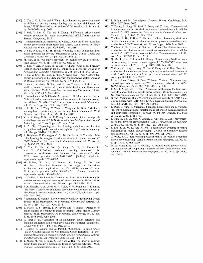
43
[290] C. Yin, J. Xi, R. Sun and J. Wang, “Location privacy protection basedon differential privacy strategy for big data in industrial internet ofthings,” IEEE Transactions on Industrial Informatics, vol. 14, no. 8,pp. 3628-3636, Aug. 2018.
[291] J. Wei, Y. Lin, X. Yao and J. Zhang, “Differential privacy-basedlocation protection in spatial crowdsourcing,” IEEE Transactions onServices Computing, 2019.
[292] I. Natgunanathan, A. Mehmood, Y. Xiang, L. Gao and S. Yu, “Locationprivacy protection in smart health care system,” IEEE Internet of ThingsJournal, vol. 6, no. 2, pp. 3055-3069, Apr. 2019.
[293] G. Sun, D. Liao, H. Li, H. Yu and V. Chang, “L2P2: A location-labelbased approach for privacy preserving in LBS,” Future GenerationComputer Systems, vol. 74, pp. 375-384, Sep. 2017.
[294] M. Han, et al., “Cognitive approach for location privacy protection,”IEEE Access, vol. 6, pp. 13466-13477, Mar. 2018.
[295] G. Sun, Y. Xie, D. Liao, H. Yu and V. Chang, “User-defined privacylocation-sharing system in mobile online social networks,” Journal ofNetwork and Computer Applications, vol. 86, pp. 34-45, May 2017.
[296] C. Lin, Z. Song, H. Song, Y. Zhou, Y. Wang and G. Wu, “Differentialprivacy preserving in big data analytics for connected health,” Journalof Medical Systems, vol. 40, no. 97, pp. 1-9, Feb. 2016.
[297] L. Zhang, Y. Zhang, S. Tang and H. Luo, “Privacy protection for e-health systems by means of dynamic authentication and three-factorkey agreement,” IEEE Transactions on Industrial Electronics, vol. 65,no. 3, pp. 2795-2805, Mar. 2018.
[298] P. Vijayakumar, M. S. Obaidat, M. Azees, S. H. Islam, and N. Kumar,“Efficient and secure anonymous authentication with location privacyfor IoT-based WBANs,” IEEE Transactions on Industrial Informatics,vol. 16, no. 4, pp. 2603-2611, Apr. 2020.
[299] Z. Li, K. Xu, H. Wang, Y. Zhao, X. Wang and M. Shen, “Machine-learning-based positioning: a survey and future directions,” IEEENetwork, vol. 33, no. 3, pp. 96-101, Jun. 2019.
[300] Y. Jia, Y. Wang, X. Jin, and X. Cheng, “Location prediction: a temporal-spatial bayesian model,” ACM Transactions on Intelligent Systems andTechnology, vol. 7, no. 3, pp. 1-25, Apr. 2016.
[301] S. B. Cho, “Exploiting machine learning techniques for locationrecognition and prediction with smartphone logs,” Neurocomputing,vol. 176, pp. 98-106, Feb. 2016.
[302] A. Brighente, F. Formaggio, G. M. Di Nunzio and S. Tomasin, “Ma-chine learning for in-region location verification in wireless networks,”IEEE Journal on Selected Areas in Communications, vol. 37, no. 11,pp. 2490-2502, Nov. 2019.
[303] F. Yin, Z. Lin, Y. Xu, Q. Kong, D. Li, S. Theodoridisand S. Cui,“FedLoc: federated learning framework forcooperative localization and location data processing,” Mar.2020, arxiv preprint arXiv:2003.03697. [Online]. Available:https://arxiv.org/abs/2003.03697.
[304] M. Polese, R. Jana, V. Kounev, K. Zhang, S. Deb andM. Zorzi, “Machine learning at the edge: a data-drivenarchitecture with applications to 5G cellular networks,” Apr.2019, arxiv preprint arXiv:1808.07647v3. [Online]. Available:https://arxiv.org/abs/1808.07647v3.
[305] U. Challita, A. Ferdowsi, M. Chen and W. Saad, “Machine learning forwireless connectivity and security of cellular-connected UAVs,” IEEEWireless Communications, vol. 26, no. 1, pp. 28-35, Feb. 2019.
[306] F. A. Hossain, A. A. Lover, G. A. Corey, N. G. Reigh and T. Rahman,“FluSense: a contactless syndromic surveillance platform for influenza-like illness in hospital waiting areas,” ACM IMWUT, vol. 4, no. 1, pp.1-28, Mar. 2020.
[307] J. Amoh and K. Odame, “Deep Neural Networks for Identifying CoughSounds,”IEEE Transactions on Biomedical Circuits and Systems, vol.10, no. 5, pp. 1003-1011, Oct. 2016.
[308] S. Matos, S. S. Birring, I. D. Pavord and H. Evans, “Detection ofcough signals in continuous audio recordings using hidden Markovmodels,” IEEE Transactions on Biomedical Engineering, vol. 53, no.6, pp. 1078-1083, June 2006.
[309] E. Vizel et al., “Validation of an ambulatory cough detection andcounting application using voluntary cough under different conditions,”Cough, vol. 6, no. 1, pp. 3-11, Dec. 2010.
[310] P. Zhang, Z. Sunand and A. Purohit, “CoughLoc: Location-AwareIndoor Acoustic Sensing for Non-Intrusive Cough Detection,” in Inter-national Workshop on Emerging Mobile Sensing Technologies, Systems,and Applications, San Francisco, June 12, 2011, pp. 1-6.
[311] Y. Zhang, M. Pan, L. Song, Z. Dawy and Z. Han, “A survey of contracttheory-based incentive mechanism design in wireless networks,” IEEEWireless Communications, vol. 24, no. 3, pp. 80-85, June 2017.
[312] P. Bolton and M. Dewatripont, Contract Theory. Cambridge, MA,USA: MIT Press, 2005.
[313] Y. Zhang, L. Song, W. Saad, Z. Dawy and Z. Han, “Contract-basedincentive mechanisms for device-to-device communications in cellularnetworks,” IEEE Journal on Selected Areas in Communications, vol.33, no. 10, pp. 2144-2155, Oct. 2015.
[314] Y. Chen, S. He, F. Hou, Z. Shi and J. Chen, “Promoting device-to-device communication in cellular networks by contract-based incentivemechanisms,” IEEE Network, vol. 31, no. 3, pp. 14-20, May 2017.
[315] Y. Chen, S. He, F. Hou, Z. Shi, and J. Chen, “An efficient incentivemechanism for device-to-device multicast communication in cellularnetworks,” IEEE Transactions on Wireless Communications, vol. 17,no. 12, pp. 7922-7935, Dec. 2018.
[316] Q. Ma, L. Gao, Y. Liu and J. Huang, “Incentivizing Wi-Fi networkcrowdsourcing: a contract theoretic approach,” IEEE/ACM Transactionson Networking, vol. 26, no. 3, pp. 1035-1048, June 2018.
[317] Y. Zhang, C. Jiang, L. Song, M. Pan, Z. Dawy and Z. Han, “Incentivemechanism for mobile crowdsourcing using an optimized tournamentmodel,” IEEE Journal on Selected Areas in Communications, vol. 35,no. 4, pp. 880-892, Apr. 2017.
[318] J. Liu, L. Gao, T. Wang, X. Zeng, W. Lu and Y. Zhong, “Crowsourcing:a novel approach to organizing WiFi community networks,” in IEEEWiOpt, Shanghai, China, May 7-11, 2018, pp. 1-8.
[319] J. Xu, J. Xiang and D. Yang, “Incentive mechanisms for time win-dow dependent tasks in mobile crowdsensing,” IEEE Transactions onWireless Communications, vol. 14, no. 11, pp. 6353-6364, Nov. 2015.
[320] N. van Doremalen, et al., “Aerosol and surface stability of SARS-CoV-2 as compared with SARS-CoV-1,” New England Journal of Medicine,vol. 382, no.16, pp. 1564-1567, Apr. 2020.
[321] L. Duan, T. Kubo, K. Sugiyama, J. Huang, T. Hasegawa and J. Walrand,“Incentive mechanisms for smartphone collaboration in data acquisitionand distributed computing,” in IEEE INFOCOM, Orlando, FL, Mar.25-30, 2012, pp. 1701-1709.
[322] F. Tian, B. Liu, X. Sun, X. Zhang, G. Cao and L. Gui, ”Movement-based incentive for crowdsourcing,” IEEE Transactions on VehicularTechnology, vol. 66, no. 8, pp. 7223-7233, Aug. 2017.
[323] J. Liu, Y. Ji, W. Lv and K. Xu, “Budget-aware dynamic incentivemechanism in spatial crowdsourcing,” Journal of Computer Scienceand Technology, vol. 32, no. 5, pp. 890-904, Sep. 2017.
[324] Z. Wang, et al., ”Task bundling based incentive for location-dependentmobile crowdsourcing,” IEEE Communications Magazine, vol. 57, no.3, pp. 132-137, Mar. 2019.
[325] M. A. Rahman and M. S. Hossain, “A location-based mobile crowd-sensing framework supporting a massive ad hoc social network envi-ronment,” IEEE Communications Magazine, vol. 55, no. 3, pp. 76-85,Mar. 2017.