Embed Size (px)
Citation preview


The Characterisation of Marton Moss
SUMMARY
1. Character Area 1 (The Mosslands) consists of the areas of small piecemeal post medieval enclosure along Division Lane, Midgeland Road up to Chapel Road and west to Common Edge Road, surrounding by busy arterial routes. It consists of the earliest cobbled buildings through to modern detached bungalows. Within the busy communication infrastructure it is an enclosed leafy landscape based around lanes, rectangular fields and drains with views limited to gaps in hedgerows across open paddocks. Any future development within this character area has the opportunity to be creative while exploring the use of red brick, ridge tiles, bargeboarding and a similar scale to fit in with traditional styles, or it has the opportunity to create a new vernacular for the mossland built from sustainable materials and energy sources in the way that development in this area started in the 18th century with locally available materials. There are means to absorb development into the area whilst retaining many of its essential characteristics i.e., by keeping the main infrastructure of quiet lanes, drains and hedgerows and by retaining the overall field pattern and some open space. In either case the original field boundaries should be retained as a link with the past, as wildlife corridors and as a way of softening the effects of development. This will create challenges in terms of highways requirements if the rural character is to be maintained.
2. Character Area 2 (Walkers Hill) consists of an area of Ancient Enclosure with some
amalgamation around Runnells Farm in the north west. This landscape also has some old historic buildings, but this is combined with some degradation and traffic noise from the adjacent Yeadon Way. Although the building stock is much degraded historically, the modern exteriors may mask earlier building fabric. They should therefore be recorded with historic analysis carried out prior to development decisions being made; this will help to identify what features should be retained. This may also require some historic building recording during works so that intrusive recording can take place and provision has been made for this in PPGs 15 and 16.This area is also of high archaeological potential and therefore any development proposals should be accompanied by a desk based assessment and if necessary and archaeological evaluation exploring this further.
3. Character Area 3 is a featureless area of modern enclosure around Wild Lane which
has been rationalised into larger fields. It is largely devoid of settlement and is marred by tall pylons. As a landscape which has undergone significant recent change it has the capacity to withstand further change, although this will result in a change of character. It offers the opportunity for high quality design and the possibility of creating a new vernacular and local distinctiveness.
Archaeo-Environment Ltd, June 2009 for Blackpool Council 2

The Characterisation of Marton Moss
rchaeo-Environment Ltd, June 2009 for Blackpool Council A 3
4. Character Area 4 (Cropper Road) is an area of post medieval planned enclosure and
modern enclosure with a mixture of open and enclosed views. It is suffering from the creep of light industrial units and encroaching busy roads. It is still semi-rural in most places and the retention of the leafy lanes and hedgerows where they exist, will limit the impact of development.
5. Character Area 5 (Moss Lane) is a small plot of land now divorced from the rest of the
study area by the rerouting of Common Edge Road. It contains no buildings but does include the former Moss Lane. The retention of hedgerows will help to protect any future development from noise pollution and soften the impact of development, but the old Moss Land should be retained as a quiet lane or bridleway.
Many of the buildings in all character areas have suffered through the inappropriate replacement of windows and doors and in some cases, new renders and elevation treatments. However a number of buildings have also been tentatively identified for inclusion in the local list as well as recommendations on the significance of each building type. Recommendations have also been made to continue the tradition of using sustainable local materials and local energy wherever possible.

Figure 1. Character Areas defined by historic landscape and built heritage

Contents
Acknowledgements 7
Introduction 8
Methodology 10
The Historic Environment and Regeneration 10
Geology 11
Historic Development of the Mosslands 11
Wider Landscape Setting 27
Historic Landscape Character 27
The Historic Landscape in Context 37
The Significance of the Historic Landscape Character 42
The Character of the Built Environment 44
The Significance of the Built Environment 52
Character Areas 55
Maintaining, Enhancing or Creating Local Distinctiveness 75
Bibliography 79
Appendix A The national significance of historic buildings and the local list 81
Appendix B Historic roads, road names and place names 90
Appendix C HER location plan 91
List of Figures
Figure 1. Character Areas defined by historic landscape and built heritage Figure 2. The Study Area
Figure 3. 1532 map of the area (taken from LUAU 1995, 53 and after Winchester).
Figure 4. Detail of the mosslands around Midgeland taken from a survey dating to 1700 (LRO DDC1/685).
Figure 5. Yates’ map of 1786
Figure 6. Hennet’s map surveyed in 1828/9

The Characterisation of Marton Moss
Figure 7. Detail of the Tithe Map for Marton dating to 1839
Figure 8. Land east of Midgeland Road (known as Midgeland Lane at the time) has had the present day landscape character since 1839 when the Tithe Map was surveyed.
Figure 9. The 1st edition Ordnance Survey map dating to 1844
Figure 10. The 2nd edition Ordnance Survey map dating to 1891
Figure 11. The 3rd edition OS map dating to 1911-12
Figure 12. Historic Landscape Character
Figure 13. Runnell Farm and its historic landscape pattern from 1847 to 1912 showing curvilinear field boundaries along Dale Bank and around the farm.
Figure 14. Midgeland Farm from 1841 to 1912.
Figure 15. The distribution of lowland mosses and grassland scrub in the county (taken from HLC)
Figure 16. Map taken from the HLC programme showing the degree of boundary loss in the county (red being the areas of greatest loss)
Figure 17. Detail of a map dating to 1700.
Figure 18. Character Areas based on the historic built environment and the historic landscape character
Figure 192. Location plan of listed buildings
Figure 20. Location map showing Historic Environment Record sites
Archaeo-Environment Ltd, June 2009 for Blackpool Council 6

The Characterisation of Marton Moss
Acknowledgements
This report has relied on research carried out by individuals and organisations who have made their knowledge publicly available. We are particularly grateful to Lancashire County Council for making their Historic Environment Record and Historic Landscape Characterisation data freely available as part of their service level agreement with Blackpool Council. Tony Sharky in the local history library in Blackpool was especially helpful and we have made much use of Nick Moore’s work on the development of Blackpool. We are indebted to the staff at the Lancashire Records Office in Preston for making the tithe maps, enclosure awards and surveys available. The plans have been produced by Andrew Miles of Blackpool Council who has been cheerful and efficient throughout. We are also indebted to Carl Carrington, Douglas Cooper and Graham Page of Blackpool Council for commissioning the work and offering valuable comments and corrections. In particular we are grateful to the many people who stopped us in the streets to enthuse about the area and tell us about their local history while allowing us to photograph their homes.
Report author: Caroline Hardie, AE
Fieldwork: Caroline Hardie and Niall Hammond, AE
Mapping: Andrew Miles, Blackpool Council and Peter Iles, Lancashire County Council
Archaeo-Environment Ltd, June 2009 for Blackpool Council 7

The Characterisation of Marton Moss
rchaeo-Environment Ltd, June 2009 for Blackpool Council A 8
Introduction
This report has been commissioned in order to inform the planning process and decision making about where and how new development should be accommodated within the Marton Moss area. This report specifically deals with the historic environment and incorporates the following:
1. A précis of the historic development of Marton Moss and its component areas in terms of land use, social history, landscape and built development;
2. A description of the current character and characteristics of Marton Moss and its component areas in terms of its historical development and its natural and built environment;
3. A detailed characterisation assessment of the landscape value of Marton Moss and its component areas in a Blackpool and Fylde context;
4. A detailed characterisation assessment of the built environment of Marton Moss and its component areas in a local and national context;
5. Recommendations on the built or landscape characteristics of Marton Moss and its component areas that should be safeguarded or strengthened through any development of the area;
6. Recommendations on the potential for statutory or local designations (if any) for built or natural environmental features within Marton Moss.

The Characterisation of Marton Moss
Archaeo-Environment Ltd, June 2009 for Blackpool Council 9
Figure 2. The Study Area

The Characterisation of Marton Moss
Methodology
In order to understand the value of the present day character of the landscape it is important to understand how it evolved into the modern landscape. In order to do this, historic mapping, archival material, aerial photographs and secondary sources on local history have been examined in order to produce an account of the evolution of the landscape in the Marton Moss area. Rapid site visits were then carried out examining field boundary types, local buildings, street patterns and street furniture and the small historic details which contribute so much to character. This fieldwork was used to identify areas where there was a change in character in both the landscape patterns and the building stock. These character areas were kept fairly large in order to keep the process simple, but as with all characterisation projects it is possible to further subdivide the area into much smaller character areas. Within these character areas, features were identified which contributed towards character in either a positive, neutral or negative way and then recommendations were made which could enhance that which was positive and change what is negative. The same information has also been used to recommend a number of buildings and features for inclusion in either the local list of historic buildings or the national list of buildings of architectural or historic interest.
The character of the Marton Moss landscape was put into a wider context through the examination of the county wide Historic Landscape Characterisation programme (HLC) which is able to provide statistics on present day survival of field pattern types and the process of change in Lancashire. Other HLC projects in the region and beyond were also examined where available, plus some national accounts of similar landscape types. This will help to determine whether the Marton Moss landscape is of local, regional or national importance, although until a nation wide HLC programme has been completed, these comparisons can only be tentative.
The Historic Environment and Regeneration
“Understanding how places change, and recognising the significance of their history, is the key to successful and sustainable regeneration”.
English Heritage 2005 Regeneration and the Historic Environment
The Government recognises that the historic environment can play an important role in the success of sustainable urban regeneration, helping to create distinctive places with a strong identity. However, it is also recognised in national planning policy that not all aspects of the historic environment can be retained; PPG15 notes that ‘the historic environment is all-pervasive, and it cannot in practice be preserved unchanged’ (para 1.3). It is therefore important to understand the relative value of the historic environment before making decisions about the future of an area. Historic places are a powerful focus for community action. The British Urban Regeneration Association (BURA), in an analysis of best practice in urban
Archaeo-Environment Ltd, June 2009 for Blackpool Council 10

The Characterisation of Marton Moss
Archaeo-Environment Ltd, June 2009 for Blackpool Council 11
regeneration, concluded that “historic buildings can act as focal points around which communities will rally and revive their sense of civic pride” (Ibid 2005).
English Heritage, the government’s advisor on the historic environment promotes the re-use of historic buildings in regeneration; their published guidance includes Regeneration and the Historic Environment, 2005, The Heritage of Historic Suburbs, 2007 and Suburbs and the Historic Environment, 2007. The latter two documents recognise the significance and attractiveness of mature suburbs and their contribution to local heritage and to the distinctiveness of the urban environment. While the mosslands are still too rural to be considered as fully fledged suburbs, English Heritage recommendations regarding the decision making process is still valid, i.e. that decisions affecting suburbs should be based on sound information about their historical significance using characterisation studies, as part of the preparation of the Local Development Core Strategy. This report is the first phase in that process of characterisation covering the buildings and the historic landscape.
Geology
Much of the Lancashire lowlands consist of Permo-Triassic red mudstones, siltstones and sandstones (‘New Red Sandstone’), but this solid rock geology is covered with glacial and post-glacial deposits. The plain’s lush green pasture and rich arable land are a creation of the last two centuries. Prior to this, the area was predominantly marshland formed by rising sea levels after the last glaciation. As the ice-sheet retreated it left behind a blanket of glacial till which now forms the coastal cliffs north of Blackpool. It also created many badly drained hollows which soon became filled with post-glacial peat giving rise to the mosses and meres which dominated the area until only recently. Place names incorporating ‘moss’ and ‘mere’ are numerous today and are associated with an abundance of well-maintained ditches and drains. Agricultural drainage systems of steep-sided ditches with localised reed beds and steep embankments are a dominant feature of the area and are responsible for the dramatic transformation from marshes to a rich and ordered landscape of neat fields, such as can be found at Marton Moss.
The Historic Development of the Mosslands1
The mosslands were traditionally studded with meres and the heavy clay soils of the densely forested glacial drift plain which combined to make this an inhospitable landscape where only the drier ridges could be developed for settlement. Aerial photographs still show a number of former watercourses across the area, now visible only as cropmarks.2 The largest ridges
1 Much of this information has come from the summary of the Historic Towns Report (2003) for Blackpool, the HER and Nick Moore’s work on the development of Blackpool 2 HER 3717, 9133, 9167, 3716, 3715

The Characterisation of Marton Moss
Archaeo-Environment Ltd, June 2009 for Blackpool Council 12
were located where Great and Little Marton and Lytham now stand, but there were also smaller areas of dry land around Walkers Hill, Peel Hill, Midgeland Farm, Marton Fold and Blowing Sands. It is to these areas that early occupation sites are most likely to be found. A flint scatter near Cropper Road suggests that some areas were occupied, even for just a short time in prehistoric times and the discovery of a bronze axe near Midgeland3 suggests that this early farm site on a hill, may well have attracted some sort of settlement for considerably longer. However archaeological finds from the mosslands are not necessarily restricted to those drier areas. Evidence of later prehistoric activity in the vicinity of the east Fylde include human remains deposited in the wetlands and hammers and spears were dredged from the ‘bowels’ of Marton Mere. Many of these stray finds from the wetland areas (as they were) probably relate to votive offerings and are therefore difficult to predict where they might be discovered in future. The quality of archaeological remains also has the potential to be very high. The Bronze Age axe from Midgeland Farm still had its wooden handle attached when first uncovered. Bronze Age animal skin coracles were found in 1850 by Mr E Jolly during drainage work whilst digging the Main Dyke of Marton Mere (Moore 2009, 11). Such well preserved organic remains are possible where the waterlogged conditions preserve wood and leather, however this must be balanced with the possibility that drainage which has taken place over the last two centuries, has dried out these remains and they no longer exist in such good condition.
Plate 1. The Bronze Age axe from Midgeland
There are some indications of Roman activity in the Blackpool vicinity. The most notable is the putative Roman road, sometimes known as the Dane’s Pad, leading from Kirkham to Fleetwood which was exposed in the bed of Marton Mere in 1850, being apparently ‘12 yards wide and 2 yards thick’ (Moore 2009, 15). From the evidence of occupation at the Roman fort at Kirkham it has been suggested that Roman activity in the Fylde generally was very
3 HER 45

The Characterisation of Marton Moss
restricted and the only known Roman sites in and around Blackpool’s urban area relates to the casual finding of coins (LCC with Egerton Lea 2005, 16).
Prior to the Norman Conquest, the entire study area formed the western part of the extensive parish of Poulton-le-Fylde. Within this parish were a number of manors. The medieval landscape of the area currently occupied by Blackpool was divided between two principal manorial holdings, Bispham in the north, Layton in the south and parts of Marton and Carleton in the east. Settlements within the manors were confined to the higher land, effectively forming a ridge between Thornton Marsh in the north and Marton Moss and Layton Hawes in the south. After the Norman Conquest, the manor of Marton was divided into two moieties in the twelfth century, leading to the development of two townships, Great and Little Marton.
The Domesday Book compiled in 1086 (Williams and Martin 1992, 795) lists Great and Little Marton as a parcel of six carucates of land. There were three settlements, set on rising ground among the swamps - they were Great Marton, Little Marton and the Peel (all just outside the study area) and none were densely populated in 1086 (ibid 796); indeed the impression is given in the Domesday Book that the area was an unknown quantity.
A map of 1532 (figure 3) clearly shows the local settlements of Little Marton, Lytham and Layton to be surrounded by open fields seemingly divided into ploughed strips. Otherwise settlement pattern is largely that of isolated farmsteads.
Figure 3. 1532 map of the area (taken from LUAU 1995, 53 and after Winchester). This is very similar to a later map dating to 1700 (see figure 4) and shows the study area to be entirely mossland
Archaeo-Environment Ltd, June 2009 for Blackpool Council 13

The Characterisation of Marton Moss
Figure 4. Detail of the mosslands around Midgeland taken from a survey dating to 1700 (LRO DDC1/685). Settlement at this stage is still largely restricted to Lytham and Great and Little Marton with only a few other isolated farms and the hamlet of Heyhouses. The moss is crossed by a road linking Great Marton with Lytham (Midgeland Road) which was also shown on the map of 1532 and a drain runs between the two areas of mossland with a sluice gate. Land on higher ground appears to be under plough.
The main development in the settlement pattern from the sixteenth century to the early nineteenth century was the growth of settlement along the margins of the mosslands, followed
Archaeo-Environment Ltd, June 2009 for Blackpool Council 14

The Characterisation of Marton Moss
by settlement of the reclaimed mosslands. It was along the edges of the mossland wastes of Marton (alias Lytham) Moss and Layton Hawes that there was the greatest expansion in settlement. Following the reclamation of wetland, there was pressure to enclose the land. As early as 1653 parts of Layton Hawes were being enclosed by agreement (and disagreements) between landowners, although there were encroachments.
At this time, settlement pattern consisted of a typical rural distribution of dispersed farmsteads with the occasional village (Great Marton and Lytham) based on the traditional medieval layout along a road with long narrow plots to the rear of properties and a funnelling for a market place at one end in the case of Lytham. Within the study area there were no such well established villages. Farmsteads were limited in their distribution by those places dry enough to accommodate them, for example Moss Side and Fold. The main thrust towards enclosure, along with the regularisation of existing enclosures, came with an Enclosure Act for Layton Hawes dated 1767. This led to the total enclosure of Layton Hawes to the west of the study area and prepared the area for settlement.
Figure 5. Yates’ map of 1786 covering the northern part of the study area showing Common Moss Road with sparse settlement along the road at The Fold and newly laid out fields at Layton Hawes, but the majority of land in the study area is still ‘waste’ and as yet unenclosed. Great Marton and Little Marton villages have a traditional medieval layout along the roadside. The regularly shaped ‘nibbled’ edges of the moss suggests that it was being used for peat cutting, increasing the distance between the moss and Moss Side and Fold.
Archaeo-Environment Ltd, June 2009 for Blackpool Council 15
The Characterisation of Marton Moss
Archaeo-Environment Ltd, June 2009 for Blackpool Council 16
The main traditional industrial activity within the Blackpool area in the early nineteenth century, other than salt making, was corn milling. A built feature of the mosslands was the Fylde windmill, typically a tower mill with a tarred timber cap in the shape of an upside down boat. While there is only one good extant example today, the mapping suggests that other examples would have broken the skyline and been visible from the majority of mosslands. Within the manor of Lytham, mills were powered by water, horse and wind and are referred to in historic documents from the 14th century, although windmills appear to have taken over by the 18th century (LCC with Egerton Lea 2006, 17). Until the mid-eighteenth century there was also a water-powered grist mill serving Great Marton, and by the later nineteenth century, there were a number of steam-powered corn mills in Blackpool. As Blackpool (and Lytham) evolved from a farming community with some fishing, to an embryonic tourist community in the mid 18th century, there grew a need to feed the growing population and the mosslands were to have a vital role in meeting this need by the mid 19th century. The tithe map for the area dates to 1839 and provides a snapshot of the growth of development in the study area at a detailed level not possible before. Much of the land, particularly east of Wild Lane was still being used for turbary plots (peat cutting). This created long fields orientated north-south which were then subdivided amongst farmers, creating a ladder appearance. The remaining mossland north of Division Lane was already sub-divided into small plots, perhaps because the peat extraction process here was now complete. The process of creating this field pattern is less well documented than the Layton Hawes area where it was subdivided by Act of Parliament, creating a more regular layout. Between the 1760s when the mossland north of Division Lane was unenclosed, but used for peat cutting and 1839 when the tithe map was drawn, significant progress was made in creating an infrastructure which encouraged investment in the mosses. This may have been due in no small way to the Clifton family, lords of the Manor since 1606 (LCC and Egerton Lea 2006, 1), who appear to have laid out a series of small lanes creating access between farms since 1786 and the 1840s. New farms were built as part of a process of agricultural improvement and enclosure appears to have been on a piecemeal basis from then on. Moss House (now destroyed), Midgeland Farm, Pipers Height, Blowing Sands and The Fold (now destroyed) all pre-date 1839;4 indeed Moss House may have been pre-1700. By 1844 the process of reclamation appears to have been largely complete and so it is clear that the present day field pattern has its origins to the mid 18th to mid 19th centuries.
4 HER 6401, 31130, 6408

The Characterisation of Marton Moss
Figure 6. Hennet’s map surveyed in 1828/9 showing that land to the west of Moss Edge Lane (as it was then) was subdivided before the mosslands to the east and settlement concentrating along the road sides which hugged drier ground. Windmills are shown to the south of Great Marton and Little Marton. The four regular north south strips below Moss Side may represent the laying out of corridors for peat cutting in advance of further sub-division; alternatively they may be roads being laid out north of School Road. Road improvements were carried out from the 1790s for the Lord of the Manor (Monks 1986, 34). The boundaries of peat cutting corridors may have determined the route of roads
Archaeo-Environment Ltd, June 2009 for Blackpool Council 17

The Characterisation of Marton Moss
Between 1812 and 1885 the Clifton estate started to acquire additional land in the south west Fylde area in order to showcase agricultural improvement and the Estate was making its own bricks and drainage tiles and pipes from 1841-3. The Drainage Acts of 1846 and 1850 allowed public money for improvements, encouraging more private investment. At this time fertilisers were also improving and becoming cheaper. The Clifton’s were major subscribers to the new railway line in 1846 which was to encourage further growth both in Blackpool and Lytham and the embryonic St Anne’s (LCC with Egerton Lea Consultancy 2006, 2) and provided a quick means of transport for fresh produce. These factors all combined to create the impetus and means for development on the moss.
Figure 7. Detail of the Tithe Map for Marton dating to 1839 with Division Lane along the bottom and Midgeland Road from bottom right to top middle. The enclosure pattern of small fields and road network, aligned east-west, has already been established on the moss. Division Lane was the township boundary and to a certain extent still marks a change in landscape character.
The 1840s saw the publication of the Ordnance Survey maps in Lancashire. The overall settlement pattern at this time was much the same as seen on the tithe map and consisted of a few cottages nestled in field corners or strung out along roadsides, with a cluster at the junction at Blowing Sands. Tree cover was limited to planted orchards within enclosures around these cottages. The largest farm was The Fold on Moss Edge Lane, as Common Edge Road was known, (now destroyed) and a group of buildings around Robbins Row also seems to be more substantial and is also now destroyed. Midgeland Farm is also shown but not named. A small school north of Division Lane served this little community; this too has since disappeared. The fields were dotted with numerous ponds, none are specifically marked as clay pits or marle pits, but these had been shown on earlier maps (1790s). A sand pit was
Archaeo-Environment Ltd, June 2009 for Blackpool Council 18

The Characterisation of Marton Moss
rchaeo-Environment Ltd, June 2009 for Blackpool Council
shown at The Fold. The names of farms used at this time went on to lend their names to roads and hamlets and remain until this day, for example Cropper, The Fold, Piper’s Height and Moss House.
Figure 8. Land east of Midgeland Road (known as Midgeland Lane at the time) has had a different landscape character since 1839 when the Tithe Map was surveyed. Here there are no residences and fields are a more regular pattern based around north-south roads which created a framework for them to develop. A number of the small ladder–like field systems were turbery plots or doles, but these are no longer identifiable on modern maps and barely visible on aerial photographs as a relict field system. The character remains different today between these two areas.
The second edition OS 6 inch map was published in 1891. By this time School Road had been straightened out and acquired a school,5 while the school which had existed along the back of Division Lane was no longer marked as such. The overall settlement pattern was however much the same with small cottages nestled into the field system. The area was still sparsely populated with only five properties along Division Lane and three along School Road (including the school) while the mapping suggests that more enclosures were bounded with hedging, although this may simply be a change in mapping detail.
5 HER 21458
19A

The Characterisation of Marton Moss
Figure 9. The 1st edition Ordnance Survey map dating to 1844
Archaeo-Environment Ltd, June 2009 for Blackpool Council 20

The Characterisation of Marton Moss
The third edition Ordnance Survey mapping dating to 1911-12 shows the level of settlement along the main roads to have increased significantly since 1891. Now all the twin terraced houses and detached brick villas were in place and the market gardens up and running. The distinct difference in both enclosure pattern and settlement pattern along either side of Midgeland Road remained. To the east, the enclosures were larger and depopulated, but to the west and north the enclosures were smaller and settlement dispersed along the roadsides. This distinction in character remains today. To the north and outside the study area, the municipal investment of roads, sewers and tramways influenced local builders creating many new streets and starting the spread of Blackpool southwards (Monks 1984, 15) towards the moss.
Aerial photographs dating to the 1940s (see plate 2) show to what extent the growth of the market gardening had changed the character of this landscape. Small fields were ploughed creating various shades of striped patterns and glass houses were the most predominant building form in the area, but housing had not grown particularly in distribution with large swathes of land along Division Lane and School Road still devoid of development.
By the 1960s additional development had taken place but this was largely the expansion of the nursery businesses rather than settlement growth per se. Available gaps were exploited for new or growing businesses along Division Lane and School Road although large parts of Midgeland were still undeveloped. Indeed around Midgeland Farm, the older field system is still visible on aerial photographs dating to that time. This has since been destroyed.
Archaeo-Environment Ltd, June 2009 for Blackpool Council 21

The Characterisation of Marton Moss
Figure 10. The 2nd edition Ordnance Survey map dating to 1891 showing an expanded road network and some hedgerow lined fields particularly north of Division Lane.
Archaeo-Environment Ltd, June 2009 for Blackpool Council 22

The Characterisation of Marton Moss
Archaeo-Environment Ltd, June 2009 for Blackpool Council 23
Figure 11. 3rd edition OS map dating to 1911-12 showing the expansion of existing nursery businesses and twin terraces and villas now in place.

The Characterisation of Marton Moss
Archaeo-Environment Ltd, June 2009 for Blackpool Council 24
Plate 2. Aerial photograph dating to the 1940s. This shows a clear distinction between character areas, which almost respect administrative boundaries. The airport appears for the first time as does municipal housing between the railway and the northern boundary of the study area

The Characterisation of Marton Moss
Plate 3. Aerial photograph dating to the 1960s showing additional development along the south side of Division Lane
Archaeo-Environment Ltd, June 2009 for Blackpool Council 25

26
The Characterisation of Marton Moss
rchaeo-Environment Ltd, June 2009 for Blackpool Council
Plate 4. A relatively modern aerial photograph showing the encroachment of new road layouts, industrial estates and government buildings. While they brought much needed employment, they have also introduced a much more modern character to the area and a relatively unattractive introduction to the mosslands. The other modern element in the landscape is the shelter belt which respects the field boundaries which have been rationalised since the 1960s
A

The Characterisation of Marton Moss
The Wider Landscape Setting
The landscape of Marton Moss sits within the Joint Character Area no.32 – the Lancashire and Amounderness Plain, as defined by Natural England (1998, 86-90). The low-lying mosslands sit to the east and south of Blackpool, while Blackpool itself is located on a drier coastal ridge with Morecambe Bay to the west. 18% of this character area is defined urban, 64% is under agriculture and just 2% is covered by woodland. Around 3% is designated as SSSI (Countryside Quality Counts). Today Blackpool forms part of an extensive built-up area flanking the Fylde coast with an agricultural hinterland and little development away from the coastal strip. The drainage of the mosslands and coastal fens during the 19th century transformed the marshes into high-grade pasture and arable land and saw the development of Victorian resorts such as Blackpool. A striking feature of the plain is the lack of historical links to the distant past. Another factor which has influenced the development of the modern landscape, relates to the drainage schemes of the 18th century. A few isolated windmills built to drain the water and grind the first crops of corn have also survived on the plain.
Blackpool is the principal urban area amongst the coastal towns that characterise the littoral of the northern part of the Lancashire and the Amounderness Plain. Together these towns form an almost continuous urban area along the coast from the mouth of the Ribble estuary to the mouth of the Wyre. Much of this urbanisation is of twentieth-century origin. The seaside character of these towns, still dominated by tourism, is a consequence of their origins as eighteenth- and nineteenth-century resorts (Natural England 1998, 88-9).
The development of settlements on the plain is a relatively recent occurrence and coincides largely with the drainage of the marshes in the 19th century and further expansion during the industrial revolution. However, the plain still remains rural in character with isolated brick farmsteads, small villages and numerous manor houses located along the network of country lanes. The field pattern in this area is large-scale with widespread loss of the field structure of hedgerows and hedgerow trees. Woodland is sparse outside of historic estates such as Knowsley Park. The varied range of crops on the Lancashire and Amounderness Plain gives a seasonally changing surface texture and colour.
Historic Landscape Character
The place name evidence for the study area relates to the landform, rather than individual’s names with farm or village endings or names derived from clearance activities. This may be significant in supporting the belief that little permanent settlement took place here prior to the Norman Conquest. ‘Fylde’ comes from the Norse, gefilde, for ‘a plain’ (Gelling, 1984, 240). ‘Blackpool’ as a name comes from the peaty water that drained from the mosses (ibid 28). ‘Moss’ is derived from the Old English mos and the Old Norse mosi for a bog and tends to be used in the north of England. ‘Mere’ is derived from the Old English mere referring to an
Archaeo-Environment Ltd, June 2009 for Blackpool Council 27

The Characterisation of Marton Moss
enclosed expanse of water (Muir 2000, 47). Blowing Sands harks back to the days when sand storms posed a real threat to settlement and common pasture resulting in proposals to move the village of Lytham inland (LCC with Egerton lea 2006, 17). Further afield, where settlement has medieval origins, at least, is Lytham, which as a place name has a variety of explanations, some of which relate to it being Old English or Norse for an area of higher ground, clearly an important factor when looking at the origins of settlement (LCC with Egerton Lea 2006, 14).
The wider landscape falls within what Rackham called ‘Ancient Countryside’ (Rackham 1990, 4-5). The historic characteristics of ancient countryside are the lack of open fields before 1700, ancient hedgerows, many small woods, non-woodland trees such as oak, ash, alder and birch and many ponds. The study area certainly reflects a number of these attributes, although its present day form is post-medieval rather than ancient. In terms of how this manifests itself in the modern countryside, settlements tend to be hamlets, small towns and/or ancient isolated farms, mixed hedges, not straight, sunken roads, many footpaths, small scale woodland, pollarding and many antiquities. What is distinctive about the study area is the long use of the mosslands as communal grazing and turbery as any other agricultural use was not practical until technology made drainage possible in the post-medieval period. Isolated farms do reflect the early settlement pattern, but they may not be as ancient as in other parts of the ‘Ancient Countryside’ because of the poor settlement conditions. The lack of enclosure until the post-medieval period also means that hedgerows here are of more recent origin and more likely to be straight than those in earlier settled places.
The field pattern within the study area is largely that of enclosure taken from mossland, however a closer examination reveals a number of different enclosure types, namely 18th and 19th century piecemeal enclosure consisting of small square or rectangular fields, the more limited ancient enclosure, usually wavy edged enclosures around the drier and therefore older settlement sites e.g. Walker’s Hill and large planned enclosures to the east of Midgeland Road representing rationalised turbery plots. In general terms the size of enclosure taken from the mosslands reflects ownership, i.e. small plots represent numerous owners adopting piecemeal enclosure and larger enclosures representing a single dominant landowner. This contrast in field types can be seen throughout the area, but particularly along the Midgeland Road and Wild Lane area.
Archaeo-Environment Ltd, June 2009 for Blackpool Council 28

The Characterisation of Marton Moss
rchaeo-Environment Ltd, June 2009 for Blackpool Council
Plate 5. Contrasting field enclosures represent differing histories of ownership – the small plots to the west of Midgeland Road are piecemeal enclosure carried out by numerous different landowners while the larger enclosures to the east represent enclosure imposed by, presumably, a single dominant landowner at a later stage (photo: Google Earth).
The historic landscape has already been characterised by the Historic Landscape Characterisation (HLC) programme carried out by Lancashire County Council and funded by English Heritage. This extensive survey has mistakenly identified some land as modern enclosure when it is in fact pre 1838, but allowing for this, the area is predominantly post medieval enclosure (that is it pre-dated the 1st edition OS map) in the central and northern areas, some modern amalgamation of post medieval enclosure in the eastern areas and to the north there is some surviving ancient enclosure. What they all have in common is their origins as mossland which places them in a slightly rarer category than most other forms of enclosure. There are c.565 hectares of mossland within Lancashire (Ede with Darlington 2002, 60). The study area occupies 200 hectares, but is categorized as enclosure taken from mossland as it has been reclaimed. Figure 12 shows the landscape in terms of its historic landscape character. This is based on what survives today in the way of field pattern and ignores the current land use. For example a caravan park is assessed according to the historic landscape it sits within and is not assessed as a tourist facility.
29A

The Characterisation of Marton Moss
Figure 12. Historic Landscape Character
Archaeo-Environment Ltd, June 2009 for Blackpool Council 30

The Characterisation of Marton Moss
Ancient enclosures
Ancient enclosure is characterised by a pond scattered irregular enclosure pattern with sinuous or wavy-edged field boundaries and winding lanes or tracks connecting a dispersed settlement pattern of isolated farmsteads and small villages/hamlets. It is usually associated with medieval or early post medieval farming practice and would be depicted on the earliest maps. The distribution of such anciently enclosed landscapes are shown on figure 12, around Runnell Farm. Here the fields are irregularly shaped and small with hedgerows and many ponds. In a wider Lancastrian context, boundaries might be hedges, ditches or drystone walls or combinations thereof, dependent upon location and normally less than 3 hectares in size. There may also have been a greater number of cobbled walls as survive in a few places in the study area, for example on Chapel Road close to the area of ancient enclosure.
Figure 13. Runnell Farm and its historic landscape pattern from 1847 to 1912 showing curvilinear field boundaries along Dale Bank and around the farm.
Plate 6. Ancient enclosure field pattern around Runnell Farm. This is small in scale with wavy edges and overall less regular than later enclosure. The boundary of the farm appears to have extended in circular swaithes between the farm and Stockydale Road. Stockydale (Dale Bank in the 1870s) may refer to the road to the doles or turbary plots
Archaeo-Environment Ltd, June 2009 for Blackpool Council 31

The Characterisation of Marton Moss
Archaeo-Environment Ltd, June 2009 for Blackpool Council 32
The other area that might be expected to have ancient enclosures within the mosslands is around Midgeland Farm which has been farmed for centuries and has not been developed. However, an examination of aerial photographs shows that the field pattern altered after 1841 and is now of modern origin.
Figure 14. Midgeland Farm from 1841 to 1912. School Lane extends to the north of the farm after 1841 and before 1891 and the row of terraces known as Robbins Row disappears from the mapping at the same time. A clay pit is constructed south of the farm and appears to be active in the late 19th century, but disused by the early 20th. It was presumably used to make bricks for building.
Anciently enclosed land in general has been farmed for hundreds, if not thousands, of years. Although the majority of the area covered by the type today is farmed as pasture it is likely that many of the enclosures were at one time used for arable cultivation. Much of the anciently enclosed land was originally brought into agricultural production from moss or wood.
There is considerable evidence for time depth in the present day landscape where ancient enclosures survive, mostly
relating to the increased quantity and diversity of historic landscape attributes. Buildings dating from the eighteenth century to the present day are to be expected, (although in other areas of ancient enclosure in the UK, one might find earlier buildings), field boundaries of different construction,
shape and form and a variety of regular and irregular routeways, such as Stockydale Road, survive to produce a complexity of historic landscape character typical of that farmed from the medieval period onwards. The origins of such character might not be instantly recognised but it is appreciated for its diversity and seeming irregularity. This landscape also has the potential
Plate 7. Pre-1840s field boundaries at Midgeland Farm are still identifiable through aerial photography in the 1960s. The old clay pit is now lined with hedging.
Plate 8. Anciently enclosed field boundaries are well masked at the north end of the study area

The Characterisation of Marton Moss
Archaeo-Environment Ltd, June 2009 for Blackpool Council 33
to contain much earlier evidence for time-depth, particularly of the Prehistoric and Roman periods. Within the study area the links between the anciently enclosed landscape and the built environment are less easy to see. Midgeland Farm exudes historic interest and may date to the 18th century, however the surrounding land has been used for landfill masking earlier landscape features. The built environment around Whalley Farm and Lilac Farm is associated with over-modernised buildings which have become badly maintained and farmyard eyesores. If the landscape was of historic interest, it is now well disguised.
Post-Medieval Enclosure
n the central study area are enclosures which have been created in
ion of
rmation of the wetlands behind Blackpool began with the construction of the Main
The majority of fields withipost medieval times (i.e. in the mid 18th and early 19th century). A comparison of the mapping from 1839 to the present day shows that the field pattern was already well established before 1840 and that it formed the framework for future development. While the enclosures may have been through some minor modification, they are largely unchanged in shape and overall form. These post medieval enclosures are small, tree or hedgelined (showing signs of pollarding), often with drainage ditches along side which also mark the routes of bridleways or pathways and a scattering of ponds throughout the area. Such enclosures fill the central study area mainly between Division Lane, School Road, Common Edge Road and Midgeland Road, although as with all character areas their changes are gradual. Time depth is more apparent here than it is in the larger planned enclosure areas as there are a greater number of historic buildings, old hedgerows and field boundaries and more historic features such as K6 telephone boxes, street lighting from the first half of the 20th century and historic lanes.
Much of the post medieval planned enclosure in the study area was defined by the locatthe drainage system which had to flow downwards and around which the newly enclosed fields and roads had to fit. Boundaries were often defined in this area by water filled ditches and hedgerows within which water loving species thrived such as the willow and alder. It was this period of enclosure which transformed this landscape more than any subsequent changes.
The transfoDyke in 1731, which created a new outflow from Marton Mere to the River Wyre at Skippool. The mere contracted significantly and most of the other wetland in the area appears to have been reclaimed by the end of the 18th century. A century after the Main Dyke was built, the Clifton family of Lytham constructed the Main Drain to drain Lytham Moss and adjacent wetlands in 1841. In the Fylde and south-west Lancashire today the post medieval enclosures are mostly retained as market gardening or horse pasture. Enclosure dating to post-medieval times occurs in a variety of forms and accounts for most of the study area. However the county wide HLC has only identified land south of Division Lane and in the north west corner of the study area as post medieval in terms of landscape character. In fact land to the north of

The Characterisation of Marton Moss
Archaeo-Environment Ltd, June 2009 for Blackpool Council 34
Division Lane is also divided and shown much as it is today on the 1st edition OS maps and tithe map and is therefore also post medieval in date, rather than modern. The difference between the two character types of field pattern is not in date, but in the form of enclosure probably resulting in the land ownership distribution and whether it was planned or piecemeal. The small fields are most likely a result of small scale landowners buying and dividing the land into small plots for market gardening, taking land from the moss on a piecemeal basis, while the larger enclosures between Midgeland Road and Cropper Road appear to be more formally laid out between the north-south road network constructed as part of the reclamation process. The field pattern to the east of Midgeland Road and west of Wild Lane also has a post medieval appearance, but it is clear from the mapping and aerial photography that the post medieval planned enclosures which once existed there, have been amalgamated into larger enclosures for the most part, possibly because they were retained or moved into in single ownership. Visually intrusive features of the 21st century landscape are more visible within this open landscape near Wild Lane, for example electricity pylons, radar masts and shelter belts.
There is also a greater coincidence between the post medieval landscape type and
osslands to the north of School Road, up to Chapel Road
common with planned enclosures but in plan have a
pollarded trees and historic trackways.
prehistoric sites registered upon the Lancashire Sites and Monuments Record, compared with the other enclosure categories. This is a result of the new enclosure of mossland leading to the discovery of new prehistoric sites.
Planned post-medieval enclosures
The enclosures within the former mare very similar to those further south but have a more regular appearance, possibly because the early provision of roads orientated north-south, created a more linear pattern within which new fields had to be divided. This area also seems to have been enclosed before the mossland to the south and being closer to Blackpool and its infrastructure appears to have resulted in a slightly denser settlement distribution. In other respects it has much in common with the piecemeal enclosure areas being enclosed with hedges and open drains and resulting in relatively small field boundaries with straight edges, some with ponds. There is less sense of time depth in these enclosures, possibly because they have a slightly greater degree of modern development and visual intrusion of industrial encroachment and traffic. Where time depth does remain to some extent is in the built environment (see below).
Post medieval piecemeal enclosures
These character types have much inmore higgledy piggeldy nature which suggests a lack of overall planning and a tendency to reclaim land as and when it was required by individual farmers or nurseryman. The resulting small fields with hedgerows, open drains around the perimeter and quiet linking lanes have created a pastoral character. There is a sense of time depth here through historic hedgerows,

The Characterisation of Marton Moss
Archaeo-Environment Ltd, June 2009 for Blackpool Council 35
Modern enclosures
In this area, most modern enclosures are post medieval planned enclosures which have h boundary change to result in a change of character. They have straight gone through enoug
field boundaries and generally create a more ordered appearance in the landscape. Time depth is not especially visible here. Wild Lane is distinguished for the most part by its lack of historic field boundaries and open nature. Attributes of former mosslands include drainage ditches, causeways, windmills and bridges, but many of these have been lost around Marton Moss. These altered areas are also subject to more modern land use such as caravan sites and industrial buildings.
Plate 9. The post medieval enclosed landscape has a more open character due to the use of post and wire fencing and drainage ditches to create boundaries. The shelter belt is out of character with the historic tree cover, but qui common on post medieval enclosed landscape types nationally.
lthough the area is renowned as mossland, all of it has been enclosed within the study area one of it has been assessed as the landscape type ‘mossland’ which constitutes
te
Mossland
Atherefore nonly 0.2% of Lancashire’s landscape as a whole (Ede with Darlington 2002, 60) and is assessed as such only if it has been unimproved. The study area has been reduced through the cutting of peat for fuel and the improvement of land through drainage from medieval times to the mid 19th century. Today most of the former mossland is used for agriculture with much of the prime arable and horticultural land in southwest Lancashire being located there and for this reason is now characterised as enclosure. What is not clear at this stage, is to what extent peat survives in local contexts and therefore the implications for archaeological survival. However, the North West Wetlands Survey of North Lancashire (Middleton et al 1995, 253) has identified a number of remaining deep peat sites which might contain valuable palaeoecological information. There are only two areas of untruncated raised mire peat and both are in Over Wyre and therefore outside this study area. There are small patches of relict raised mire in the Fylde, the nearest being at Peel and therefore outside the study area. No other deep peat sites were identified in the study area and therefore it would appear that there

The Characterisation of Marton Moss
Archaeo-Environment Ltd, June 2009 for Blackpool Council 36
are likely to be better peat deposits surviving elsewhere in Lancashire. The report also suggests that the peat was removed from the ground before peat roads were laid out between 1786 and the 1840s therefore even under historic roads, peat survival may be limited (ibid, 104), however there is some survival of peat deposits, albeit it rather thin, under the blown sands of Lytham St Anne’s and the western part of the study area.
0 6 12 Kilometers
Moss and Grassland/ScrubCounty boundary
Even in the small number of locations where lowland moss survives it has usually been truncated by earlier digging and has shrunk due to the dewatering of the surrounding improved farmland. This clearly has a knock-on effect for the survival of archaeological and palaeo-environmental evidence (Ede with Darlington 2002, 60). This process of de-watering has a long history in the Marton area. In 1346, Spen Brook drained Marton Moss. It was later widened, deepened and renamed Spen Dyke. Marton Mere was a large lake, running east and west for four and a half miles from the present East Park Drive to beyond Peel. An overflow ran through Marton (from where Cornwall Place is now) and joined Spen Brook near what is now Spen Corner. The Mere originally drained into the River Ribble near the present town of Lytham. Not until the 1850s, was a Main Dyke dug to drain it into the Wyre at Skippool, so making the mere the man-made feature it is today. The Moss was also used for peat cutting; a right which was given to the Monks of Cockersand Abbey in 1260. Surveys for the Clifton Estate in the records office list the occupiers in the area who retained the right of turbary through the 1700s (LRO DDC1/519,520) and the tithe map of 1839 also lists a number of turbary plots. Each farmer had his own ‘dole’ in order to cut moss and trackways to lead out into the moss to access it. Once peat had been removed, the farmer had the right to use the land beneath it for grazing or cultivation. As each turbary was worked out, it would be enclosed and reclaimed, while the owner moved on to win his fuel from the next plot of uncut peat further into the moss (Winchester 2006, 100). Therefore when considering the
Figure 15. The distribution of lowland mosses and grassland scrub in the county (Taken from HLC)

The Characterisation of Marton Moss
Archaeo-Environment Ltd, June 2009 for Blackpool Council 37
archaeological and paleoenvironmental potential of the mosslands, it is clear that the process of drying out dates back to medieval times and in much of the study area it is likely that very little peat remains.
Mosses and areas of rough grass would have played an important part in the former agricultural system, particularly as other parts of the landscape were increasingly enclosed for
terisation programme has recommended a number of
♦ In Lancashire, ancient enclosure (pre 1600AD) concentrates in the lowlands ith a subsequent expansion of agriculture into both the low lying wetlands
♦
mmunications and light industrial
♦
l degraded example of this in the study area
♦ The majority (80%) of post medieval and ancient enclosures in Lancashire
private use. They all afforded areas of common grazing, whilst the mosses also provided other products such as fish and game, peat for fuel, rushes for lamps, reeds for thatching and woodland fringe resources for basket making (a once traditional industry of West Lancashire). The lowland mosses of the Fylde area are distinctive in character and land use from the mosses of Cumbria which tend to support commercial peat cutting as opposed to the market gardening of south-west Lancashire.
Because the mosses are a relatively rare landscape type within Lancashire, the County Council’s Historic Landscape Characways to preserve or enhance the landscape type (Ede with Darlington 2002, 103), however this assumes that the mosslands are intact. In this study area, they appear to have been exploited for peat cutting and subsequently grazed or developed and will thus have drained significantly. However the open drains still flow with water and the trees which grow around the field boundaries are still water resistant species, therefore there must be some archaeological potential for well preserved organic remains. The Historic Landscape Character in Context
Summary:
wand higher uplands. This is reflected in the study area where the mosses were not enclosed until the 18th and 19th centuries
Enclosed land is the most extensive landscape type in the county and accounts for all the study area (excluding couse)
Ancient enclosure accounts for 25% of Lancashire as a whole. There is only a smal
♦ Post medieval enclosure accounts for 62% of Lancashire and most of the study area
♦ Modern enclosure accounts for 13% of all enclosed land in the county
have not changed much in the last 150 years.

The Characterisation of Marton Moss
Archaeo-Environment Ltd, June 2009 for Blackpool Council 38
♦ Most enclosures in Lancashire are small in scale reflecting piecemeal enclosure rather than parliamentary planned enclosure
It e the historic landscape of the mosslands in a wider context by omparing the area with the county wide HLC programme and similar programmes
♦ Most of Lancashire’s mosslands had disappeared by 1840 and are now in a diverging landscape
♦ The Marton Moss area is therefore fairly typical of Lancashire’s historic landscape
is possible to placcelsewhere. The comparisons may not be wholly accurate as HLC by its very nature is broad brush, but it should be possible to obtain some sense of rarity value of each landscape type. The study area is now enclosed land which accounts for well over half the land area of Lancashire (62% or 201,905 hectares) (Ede with Darlington 2002, 37) and is therefore relatively common. Indeed it is the most extensive historic landscape character type in the county and within the study area. It is also the most extensive landscape type within the contrasting upland landscape of the Lake District where it forms 50% of the landscape (Newman and Hardie 2007, 30). In terms of the County Landscape Strategy, the study area falls within the Mosslands character area, more specifically the South Fylde Mosses (LCC 2000, 95). It notes that the rural and tranquil character of this mossland has been eroded by the proximity of new development, industry and camp sites. Comparing this mossland to others in the county, the Strategy notes that the North Fylde mosses are less developed and Winmarleigh Moss is the largest surviving area of uncultivated peat mossland in the county. The character of Marton Mere and the South West Mosses has also suffered through new development and reclamation, but there is also evidence of pre-drainage occupation. The Skelmersdale Mosses have been largely reclaimed for farming and have become an intensively farmed arable landscape overlain by more recent enclosure, electricity pylons and geometric woodland. Tarleton Mosses are densely settled and are covered with numerous glasshouses and development is dominated by modern bungalows; traits which are also to be found in the study area. Haysham Moss is an open pastoral landscape, only a small part remains uncultivated. Similar factors also erode the rural character of this mossland, namely encroaching urbanisation, traffic movement, pylons and in the case of Haysham Moss a power station. Hoole and Farington Mosses are fringed by settlement and is mostly cultivated and drained. However there is a pocket of moss with remnant bog vegetation. The mosses of Lancashire are therefore all similarly altered by reclamation and subsequent development, although the North Fylde mosses appear to be more intact than those in the study area. Despite the small pockets of surviving mossland, the mosslands of Lancashire had essentially disappeared in the 40

The Characterisation of Marton Moss
Archaeo-Environment Ltd, June 2009 for Blackpool Council 39
years after 1800 (Williamson 2000, 126). Recent research into how our landscape is changing nationally has placed the study area in a ‘diverging’ landscape; that is one where landscape character is transforming so that new patterns are emerging. It also noted that the ‘Mosslands are fundamental to the character of the area as semi-natural habitats and as historical features, but they are apparently in remorseless decline. Drainage ditches (ironically) are also important features’ as are ponds which are being sustained in number. (Countryside Quality Counts 1998-2003)
Ancient enclosures
Of the enclosed land in Lancashire, ancient enclosure accounts for 39% of enclosed land. urvives in only a few small places within the study area and is therefore
The majority of the study area consists of post-medieval enclosure. The late enclosure date of technological difficulties of drainage and improvement of the
Ancient Enclosure srelatively rare in a Blackpool/Fylde context (see figure 12). However within the context of the whole county, ancient enclosure covers almost 25% of Lancashire (79,431 hectares).For comparison, ancient enclosure forms 59% of enclosure in the Lake District (Newman and Hardie 2007, 56) where the lack of development has led to a greater survival of this landscape type. The National Park landscape therefore has a greater degree of anciently enclosed landscape than Lancashire does which is hardly surprising. In Cheshire 18% of the county consists of anciently enclosed land, or put another way, 29% of all enclosed land is ancient. However only 1% of ancient enclosure in Cheshire is in the form of moss rooms (Cheshire County Council 69). Lancashire therefore has a higher degree of anciently enclosed land than Cheshire, but not as high as the Lake District.
Post Medieval Enclosures
the mosslands relates to the mosslands, so that they remained as common grazing much later than other low-lying areas in the west of England. In a county context, the post-medieval enclosure HLC type covers 30% of Lancashire (96,953 hectares) and accounts for 48% of all enclosed land in the county. It is therefore less rare than ancient enclosure in the Blackpool/Fylde area. For comparison, post-medieval enclosure accounts for 27.8% of Cheshire, (or about 45% of all enclosed land) and so has a similar distribution to Lancashire. Likewise, 41% of enclosed land within the Lake District National Park is post medieval enclosure (Newman and Hardie 2007, 56). In Lancashire, field size tends to be medium (4 to 16 hectares) but with a significant percentage of small enclosures. Two thirds of the type has an irregular layout with one third showing a more regular, planned pattern. This is a reflection of the piecemeal private enclosure of land in Lancashire (and in the study area) in the period between AD1600 and 1850, rather than the widespread planned enclosure more prevalent in other parts of England such as the Midlands. Water-filled ditches bound one fifth of post medieval enclosures in the county. These mainly occur in south-west Lancashire and the Fylde (the areas of reclaimed moss) with outliers around the Bowland fringes and in the Silverdale and north Lancashire areas.

The Characterisation of Marton Moss
Archaeo-Environment Ltd, June 2009 for Blackpool Council 40
Therefore of the enclosed mossland, the study area includes a significant proportion of the reclaimed mossland in the county.
The origins of enclosure in Lancashire spilt into two clear geographical areas on either side of the M6 corridor (roughly). To the lowland west of the M6, enclosure is largely taken from
126), creating a similar field pattern with drainage ditches to that
mossland and to the east it is largely taken from upland moor and woodland (Ede with Darlington 2002, 96). In Lancashire 13% of the post medieval enclosure type is on areas that were formerly mossland and so it is not especially rare. This is a significant increase over the earlier period (over 16,000 hectares compared with less than 1,000 hectares recorded in Ancient Enclosure). There are 1,784 hectares of long, thin, straight-sided enclosures (moss ‘dales’ or ‘doles’ – strips of moss allotted to commoners to cut peat prior to drainage) in former mossland areas in Lancashire. They tend to relate to the later drainage of mosses (18th to early 19th century) with its regular pattern, such as is seen in the study area. Of the post medieval enclosure reclaimed from mossland, 52% was judged to have been reclaimed between AD1600 and 1850, whilst a more specific reclamation period dating between AD1750 and 1850 (probably much of the study area) could be ascribed to the remaining 48%. These date categories were assigned on the general assumption that later enclosures tended to have a more regular layout and larger fields with straighter routeways. A large proportion of this type on reclaimed mossland exhibits an enclosure pattern that is different to that on the 1st edition O.S. maps but where the skeleton of the old pattern is still discernible today. 70% of the type has water boundaries, most of which lie on the ‘seasonally wet’ soils (rather than the ‘freely draining’ soils).
For comparison, only 0.3% of Cheshire is considered to be planned from marshland (Cheshire County Council, found in the study area. At a Lancashire County level the HLC programme has therefore recommended conserving post medieval enclosures which have derived from mosslands because of its significant contribution towards landscape character in the county. It also suggests retaining the characteristic pattern and features of lowland moss enclosure in order to retain historic character (Ede with Darlington 2002, 103). A significant proportion of post-medieval enclosed mossland has already been lost either to urban expansion or later agricultural rationalisation. What remains tells an important story of post-medieval agricultural improvement within the county (and nationally) and mirrors social and technological changes taking place within both the countryside and adjacent burgeoning industrial towns. Lancashire’s HLC also suggests highlighting evidence for time depth in this landscape in order to enhance the visual links with the past. These recommendations have been incorporated into the proposals for enhancing the character of the landscape towards the end of the report.

The Characterisation of Marton Moss
Plate 10. The modern enclosure landscape character has been altered with modern day features such as pylons
LancashireDegree of boundary losswithin enclosed land
0 6 12 Kilometers
Green is area with little or no boundary lossBlue is area with some boundary lossRed is area with much boundary loss and change
Loss of field boundaries
The HLC mapping has illustrated that, since c.1850, the greatest degree of boundary loss within the county has occurred in West Lancashire. Here reasons for such change may be found in the impact of commercial rationalisation, prompted by the considerable local demand from Liverpool and neighbouring towns, and the high quality of the former mossland soils. There are other small areas
of great boundary loss scattered through the rest of the county, most notably that of the southern Fylde, reflecting on a reduced scale the processes witnessed in West Lancashire (Ede with Darlington 2002, 95). Boundary loss is not always a reliable indicator of character change however. It is clear that the small enclosures within the study area have been modified and had a number of dwellings built within them along street frontages, but the overall character has not altered to the same extent due to the remaining hedgerow and tree cover and the lack of visual intrusion along the quiet lanes.
Figure 16. Map taken from the HLC programme showing the degree of boundary loss in the county (red being the areas of greatest loss)
Comparisons with HLC data from other counties gives us some insight into the rarity of different field types, but it does not give us an insight into the cultural values of local or national landscape types. Wetlands were once an important resource nationally, as well as locally. Most of them have gone through a process of drainage and reclamation, but they still contribute towards our sense of place and local distinctiveness. For example, the presence of the moss has lent its name to lanes, streets and houses, it has defined the growth of settlement in terms of where and when it developed, it has been used as an administrative
Archaeo-Environment Ltd, June 2009 for Blackpool Council 41

The Characterisation of Marton Moss
boundary and it has defined where the communications network could spread. For centuries it has provided wildfowl and fish for food, peat for fuel, reeds for thatching, rushes for candles, willows for pollarding, rough grazing for livestock and more recently high quality soils for market gardening. Despite the fact that the mosslands have long since been reclaimed, the cultural heritage suggests that they still exist even if it is only in the language and place names.
Significance of the historic landscape character.
The historic landscape has particular significance at a local level as it has created a particularly distinctive field pattern around which development has taken place on a piecemeal basis. This gives character area one in particular, a distinctive sense of place making it quite different to other semi-rural places in the UK. The remaining character areas are now diminished by modern light industrial development and a busy communications network which have detracted from local distinctiveness. However the mosslands themselves are now largely destroyed (or much degraded) and sit below a more recent field pattern. This is not unique to Marton Moss, but is a story that has unfolded on wetland areas from Somerset to Cumbria. Enclosed landscapes are not rare and can be found throughout the lowlands of the UK, although the transition from common mossland to market gardening and 20th century development has created a very distinctive Fylde–like landscape quite different to the former mosses of Cumbria. Anciently enclosed landscapes are rarer, but within the study area, the small patch of surviving ancient landscape is much degraded and so better examples can be found elsewhere. In summary:
Landscape type Significance
Mossland Now reclaimed therefore loss of peat and
wetland and reduced potential for well-
preserved archaeological remains.
Archaeological and paleo-environmental
potential can be evaluated as part of the
planning process, but could be high if peat
and waterlogging remains
SOME
Ancient enclosure Field system shows some signs of ancient
enclosure, but now largely degraded with
dumping and close proximity of traffic – high
potential for early buildings to be encased
within existing buildings stock. High
archaeological potential which may need
further assessment and evaluation.
CONSIDERABLE
Archaeo-Environment Ltd, June 2009 for Blackpool Council 42

The Characterisation of Marton Moss
Post medieval
piecemeal
enclosure
This has created a particularly distinctive
landscape character and has resulted in
piecemeal development resulting in a leafy,
enclosed landscape with considerable local
distinctiveness
EXCEPTIONAL
Post medieval
planned enclosure
This landscape is degraded by the proximity
of light industrial development and a modern
communications network
SOME
Modern enclosure A former post medieval enclosed landscape
which has since been amalgamated into
larger fields, very common throughout
England. Relatively featureless and
diminished by pylons.
SOME
Ponds and water
filled boundary
ditches
Ponds have been a feature of this landscape
since it was drained and are an indicator of
ancient countryside. Many have been used
for small scale industrial use. In a national
context many ponds have been lost to
development and so are increasingly rare,
however the rate of loss has fallen.
Waterfilled ditches are an essential part of
the character of this post medieval enclosure
landscape providing water tolerant species
with habitats, but also draining any remaining
peat
CONSIDERABLE
Archaeo-Environment Ltd, June 2009 for Blackpool Council 43

The Characterisation of Marton Moss
Archaeo-Environment Ltd, June 2009 for Blackpool Council 44
The Character of the Built Environment
Buildings within the mosslands owe their architectural traditions to the relatively recent past; for the most part to the 18th century and later. On drier land, where settlement occurred earlier, medieval buildings were probably cruck built, but this tradition continued later around the mosslands, with reused crucks, due to the relative poverty
of good building materials. This lack of building materials also resulted in a long association with cobblestones and manure as building materials, from medieval times, but on the mosslands, mainly in the 17th and 18th centuries with limited brick for later patching. The cobbled surface was whitewashed which helped to hold the structure together and acted as a fungicide and pesticide. Such cottages
were normally two or three bays depending on the status of the owner, but while they convey a homely traditional style today, in 1876, Anthony Hewitson a journalist, described the architectural character of the flatlands as ‘degenerate wigwams’ (Pevsner 2009, 21). Photographs of surviving cottages taken at the end of the 19th century, plus an examination of those which have made it to the 21st century suggest that they had a central doorway with porch. Above the ground floor was a small attic storey, perhaps only initially accessible by a ladder and visible from the front as small windows tucked under the eaves. Cobbles were not just used to build the houses. Boundary walls were also constructed from this material and
only a few examples can now be found in the area peering out from hedgerows or glimpsed from a travelling car (see plate 11). Earlier examples are roughly coursed cobbles bounded with mortar (see plate 11), but later examples tend to be more decorative with rows of colour co-ordinated cobbles often seen in front of cobble cottages. They are also distinctive of the Lytham St Anne’s area and the South
Shore area of Blackpool. The traditional roofing material of this area was thatch,
the mosses providing a sustainable source of reeds. Some thatching can still be seen dotted throughout the moss, but it is relatively rare and during the 19th century many thatched roofs were replaced with corrugated iron. A possible cobble cottage with corrugated iron can still be seen on Midgeland Road.6 This was Pods on the 2nd edition OS map and although the farmhouse was demolished in the 1920s, the remaining building appears to be the farm
6 NGR 34370 31420
Plate 11. A piece of surviving cobble wall on Chapel Road
Figure 17. Detail of a map dating to 1700. The houses are depicted as timber framed with red pantiled roofs. There is no evidence that this is how the houses at Marton appeared, but is presumably a symbolic representation only. However the post built windmill is an accurate representation.

The Characterisation of Marton Moss
Archaeo-Environment Ltd, June 2009 for Blackpool Council 45
buildings which have survived, but were recently granted planning permission to be demolished. At Midgeland Farm the thatch was left in situ and the corrugated iron placed over the top (see local list recommendations). It is likely that higher status buildings were roofed in stone slate and once the railway made the importation of building materials easier from the mid 19th century, a mixture of Cumbrian and Welsh slate was used. The use of brick for later alterations was a forerunner of brick being the main building material in the area. Initially brick was locally produced but by the later 19th century brick and terracotta were being imported from east Lancashire (LCC with Egerton Lea 2006, 38). Cobble cottages were patched with brick, and, chimneys, regularly replaced, were quickly constructed from brick. Cobbles with brick are a feature of walling at Walker’s Hill Farm and two possible encroachment cottages off Common Edge Road (No.s 166 and No.s 1 and 2 Fisher Lane) (Lancashire County Council and Egerton Lea Consultancy 2005, 44) and at Midgeland Road. The cobbled farm building at Whalley Farm has been encased entirely in brick, rendered and modernised beyond recognition as an historic building. Windows were predominantly Yorkshire sliding sashes or the occasional multi-pane casement or sash, particularly on ground levels. Pennine Sandstone was also used for dressings in the 19th century, mainly lintels and sills.
Plate 12. The typical 18th and early 19th century house was the Fylde long house, made of sea cobbles, patched and altered with brick and held together with lime render. Roofing was in thatch and windows were multi-pane Yorkshire sliding sashes. Very few of these survive, although many more may be masked by later modifications, but the low and long cottage style lends itself well to creating a modern vernacular for the area. By the late 19th century, small cottages were being sold off to former tenants, auctions sometimes taking place at the old Shovels Inn (Mr Tom Boardman pers comm.). The new

The Characterisation of Marton Moss
owners were no longer happy with the squat little cobble cottages and aspired for something larger with lighter brighter rooms. They were replaced with one of three main Victorian styles.
Plate 13. A typical late 19th century detached villa with carthouse behind. This example on Stockydale Road has retained many of its traditional features; a relative rarity in the study area
For the wealthier owner, normally the owner of a small nursery garden, a Victorian brick detached villa with stone dressings and sash windows was what contemporary fashions required. Additional design features included terracotta ridge tiles and finials, pierced ornate bargeboarding, central ornate window mullions carved in wood or more simple stone mullions with a slight chamfer. Some front garden was now required for the family of modest means. This was bounded by brick walling and gateposts, often stone gateposts in the same style seen throughout the growing town of Blackpool or red brick ones with detailing. Each villa
needed a cart house, much as houses need garages today. This was normally built to the rear of the villa and was also made of brick. Buildings now had slate roofs rather than thatch, slate being brought in by rail. Once the new house was built, sometimes behind or alongside the old cobble cottage, and the furniture moved in, the old cottage was usually demolished. Nevertheless a number
Plate 14. A pair of terraced houses, the one on the right still retains its traditional windows and doors
Archaeo-Environment Ltd, June 2009 for Blackpool Council 46

The Characterisation of Marton Moss
Archaeo-Environment Ltd, June 2009 for Blackpool Council 47
survived to be rented out and did not meet their end until many decades later.
Nursery gardens also required some staff and to meet their needs groups of two terraced houses were constructed along the main roads. They were also constructed of brick with stone lintels and sills and slate roofs. These terraces may have been more modest, but they were still supplied with ornate details including sash windows, decorated bargeboarding and solid front doors. It was all the rage in Victorian times to mark the name of the house on the gatepost and the garden walls adjoining it were often of brick. The best brick was used at the front of each house, glossy and red with fine white pointing, while smaller rougher bricks were used for the side and rear elevations. By 1891 a little row of terraced houses had been built at
Mad Nook on the site of an older cottage.
Plate 15. Worthen House today behind Division Lane, built after 1892 to replace a cobble cottage by Mr Boardman
In 1892 Mr Boardman bought his rented cobble cottage just behind Division Lane from the Clifton Estate and started work on his new brick villa, Worthen
House with its carthouse, stables and washhouse next door. The cottage was subsequently demolished and trees planted on the site. From the 1890s these new styles were to spread throughout the area and along each road today, these twin terraces can still be seen, albeit now joined by 20th century infill.
d
Some speculative development was also taking place in the northern section of the study area around Stockydale Road and the north end of Midgeland Road. Here land was purchase and developed by private individuals seeking additional income. Terraced houses, such as those once called Platt Cottages (named after a local brickmaker) and Halls Cottages (1897) on Stockydale Road were the favoured style built in brick with stone finishings, decorated brick chimneys, matching front doors and sash windows. Small front gardens with pretty stone gateposts and low brick walls, and back yards with privies completed the late 19th century look. They were usually built in pairs, as in the Division Lane area, but were quickly infilled to create rows of houses which have since been added to. While these areas are more densely populated today, largely due to additional development, they still have easy access to quiet rural lanes and are sitting within a landscape scattered with nurseries. This development continues with more recent bungalows dating from the 1930s along St Nicholas’ Road and the 1970s along Stockydale Road. However they are now sandwiched between busy urban

The Characterisation of Marton Moss
roads, of which Progress Way, brings New Hall Lane and Jubilee Lane to an abrupt and noisy end.
Plate 16. Rows of brick built terraces from the late 19th century, a result of speculative development. The unusual triangular door lintels are also seen at Rosehill Cottage on Chapel Road. Also not the typically Blackpool gatepost in painted stone on the street front and the glazed capstone son the low red brick garden walls – all distinctive to this area.
Another style of Victorian house is now missing from the area but was once better represented. Neo-Gothic styles were fashionable in the mid to late 19th century and were built in response to a rejection of earlier classical Georgian styles and a romantic redesign of earlier English architectural traditions. The use of a high degree of ornamentation such as decorated bargeboards, pinnacles and tall gables created tall, light ornamented structures. Many of these features continued to be used in modest terraced houses and can still be seen today, but small detached cottages were also built, set within their own garden and often associated with a nursery. These cottages are now largely demolished to make way for modern development and survive best in the historic photographs of the area and at Lytham and Blackpool.
Archaeo-Environment Ltd, June 2009 for Blackpool Council 48

The Characterisation of Marton Moss
Plate 17. Cropper Road nurseries built in 1872 and now demolished to make way for the Peel Road industrial estate. The use of decorated bargeboards on the side elevations, the dormers and the central porch, plus the pinnacles on each gable and tall chimneys heightened the house to create an airier more spacious cottage than the earlier cobbles cottages.
A number of buildings dating to the 1930s are scattered throughout the area. These were mostly two storeyed semi-detached houses with harling at first floor level and brick to the ground floor. Doors were of timber often with oval or multi-paned half glazing and windows were often designed with horizontal glazing bars, sometimes in metal. Few of these features now survive. The houses were designed to be brighter and lighter than their Victorian predecessors and with larger garden plots. Similarly the traditional 1920-30s bungalow is also present, particularly along the more densely populated School Road, also with large garden space, a central doorway and large bay windows on either side. The bungalow now took a pick and mix approach to detailing, borrowing small design features such as terracotta finials and ridge tiles from Victorian traditions, mock half timbering from Tudor times and lead glazed windows from medieval times.
Archaeo-Environment Ltd, June 2009 for Blackpool Council 49

The Characterisation of Marton Moss
Archaeo-Environment Ltd, June 2009 for Blackpool Council 50
Plate 19. A 1930s bungalow with central doorway and bowed windows. Bargeboarding here is plain and the red brick boundary wall reflects earlier traditions.
The character of the mosslands today is derived from a combination of factors including the built environment and the historic landscape. In terms of the built environment, this character is not just derived from the buildings, but also ‘The historic layout of roads, paths and boundaries; characteristic building and paving materials; a particular 'mix' of building uses; public and private spaces, such as gardens, parks and greens; and trees and street furniture, which contribute to particular views - all these and more make up the familiar local scene’ (English Heritage accessed 14.6.09).7
7 The English Heritage web site http://www.english-heritage.org.uk/server/show/nav.00100200800g008 relating to Conservation Areas but equally applicable to any historic environment
Plate 18. a typically 1930s building in the moss area with a harled top floor and brick ground floor and standard 1930s half glazed door. The windows are later replacements

The Characterisation of Marton Moss
The moss area today is rural in character with a mix of horse grazing land, remaining glasshouses and residential dwellings with industrial development to the edges and some caravan sites. The landscape is generally open in character except along the hedge lined lanes which are enclosed and shady. Communications routes are a mix of the very modern Progress Way, the starkly exposed prairie-like Wild Lane and the leafy rural lanes such as
Kitty Lane. Cutting through it in a ruler straight determined manner is Division Lane. In appearance it has all the features of an 18th century surveyed boundary, but it’s course has been a boundary in this landscape since the 12th century when a boundary cross marked the division between the Saxon village of Lytham and the Manor of Layton. Along the main roads, such as Common Edge Road and School Road, there has been a greater change in character from the 1950s with more dense development and associated road widening and straightening in
response to, or arguably creating, a general increase in traffic and traffic signs causing a significant dominance of the car over the pedestrian and a much more urban feel than that to be
found along the lanes. Midgeland Road (the northern part), School Road and Common Edge Road have all been widened and new ring roads constructed from the 1950s. This has resulted in a divorcing of historic setting from those significant historic buildings remaining and a loss of visible historic links to the past. It has also resulted in a name change for most of the major roads from Lane to Road. On the positive side, it has removed any reason for through traffic along the quieter lanes, thus helping to retain the rural character.
Plate 20. A 1920s finger post is dwarfed by modern street signs
Plate 21. Midgeland Road (Lane as it was) c.1900 facing south. At this time it is still a muddy lane with drainage channel and a very different character to today’s busy road.
Archaeo-Environment Ltd, June 2009 for Blackpool Council 51

The Characterisation of Marton Moss
The open landscape around Wild Lane is marred by the obtrusive electricity pylons and sub station which are located within an area with no hedgerows to obscure them from view. There are relatively little historic anchors visible within the area; the hedgerows are the most visually dominant historic feature and occasional traditional street signs might be spotted, but often in poor condition or ex-situ.
The built character of the mosslands today, particularly around Midgeland Road, and Division Lane, plus the various lanes which lead off, is based mostly on development which has taken place in the later 20th century. These ‘individual’ style of detached houses set behind gates often flanked by gateposts topped with horses heads and enclosed with high hedges or fences, display a quest for privacy, competing with a desire to show off the new wealth that
such development has brought into the area. A penchant for palm trees in the gardens and electric ornate gates creates a suburban feel that would not be out of place in any middle class suburb in the English speaking world. There is no one distinct style, the character of these buildings range from hacienda style bungalows to art and crafts style villas occasionally adopting historic designs to help them fit into the existing character of the area such as terracotta ridge tiles and finials. The development of the
mosslands is therefore not easily mapped as no large scale development has taken place as one might expect around a medieval town, but instead development has been piecemeal, on a plot by plot basis. The lanes are still hedgelined with drainage channels along the edges creating a water feature for the new
settlers. Small paddocks are still spread throughout the area, most with horses grazing and many still with glasshouses, although a number are now derelict, but these glimpses across pasture fields towards distant houses creates a rural feel to the area much cherished by local residents. Many of the lanes have not been resurfaced recently and this contributes towards the rural sanctuary that this area has become. However despite its changing status towards a middle class suburb, the area is not without its eyesores. Abandoned businesses create areas of dereliction, disused buildings are falling quietly into decay and where 19th century buildings survive they have suffered from a loss of traditional windows and doors, although other features such as decorated bargeboarding have survived rather well.
Plate 22. Horse head gateposts dominate in the mossland lanes, although a variety of other designs can be found too including parrots, pigs and acorns.
The Significance of the Built Environment
All buildings and structures contribute in some way towards the character of the mosslands area, but some make a greater positive contribution than others towards historic character. The following table summarises the approach that is recommended for each existing building type in the area if historic character is to be retained or enhanced.
Archaeo-Environment Ltd, June 2009 for Blackpool Council 52

The Characterisation of Marton Moss
Table 2. Generalised statement of significance for each type of building
Building type Criteria Significance
Cobbled long houses and pre 1840s farms and farm buildings
Cobbled long houses are now rare; some are listed and therefore nationally important; others may exist which have not yet been identified. Brick built farms are a link potentially to pre reclamation agricultural practices and define areas of higher ground likely to have been occupied earlier. They are particularly important if located in the north of the study area which is along the moss edge. They are few in number so do not dominate the character of the area, but they do enhance time depth, contain valuable archaeological information and add to the architectural character and variety of the mosslands. They are an easily recognised and tangible link with the past because of their small windows and thatched roofs or hand made rustic brickwork.
EXCEPTIONAL
19th century twin terraces and villas
These are an important part of the process of development of the mosslands and a tangible link with the past. They add to local distinctiveness because of their brick built design and use of bargeboarding. Their link with the growth of market gardening and their association with paddocks and glasshouses is also important. They have suffered from a loss of historic character through the inappropriate replacement of windows and doors.
EXCEPTIONAL
19th century terraces These are an important part of the character, particularly along the main roads (School Road, Stockydale Road and upper Midgeland Road) where settlement is most dense. Many display date
CONSIDERABLE
Archaeo-Environment Ltd, June 2009 for Blackpool Council 53

The Characterisation of Marton Moss
stones and early names and have retained their decorated bargeboarding. However they are not especially distinctive of the local area as they can be found in most towns and cities and have suffered from an erosion of historic character brought about by the inappropriate replacement of windows and doors and in some cases render or pebbledash has covered over the red brickwork.
Early 20th century houses, arts and crafts villas and traditional bungalows
For the most part these buildings contribute towards the character of the area by retaining a distinctive form of ornamentation which is either unique, or which relates to earlier architectural styles, for example the use of terracotta ridge tiles and finials. These too are now suffering from the inappropriate replacement of windows and doors and some around Old House Lane are falling into disrepair.
CONSIDERABLE
Mid to late 20th century houses
For the most part these houses have lost any local distinctiveness and could have been built anywhere. They are built from a mix of material not found in this area before the 1950s. They have also reduced the amount of ornamentation. Houses dating to, or largely modernised in, the 1960-80s are not wearing well and are introducing a shabby element to otherwise well-maintained streets and lanes. Most are detached with large gardens based within plots formed by piecemeal enclosure, have tall gateways and boundary walls or fences and there is a predominance of horse headed gateposts and palm trees.
SOME
Late 20th – early 21st century houses
These more recent houses represent a shift towards re-introducing traditional materials, especially red brick, ridge tiles and finials
SOME
Archaeo-Environment Ltd, June 2009 for Blackpool Council 54

The Characterisation of Marton Moss
rchaeo-Environment Ltd, June 2009 for Blackpool Council A 55
combined with modern designs and more energy efficient materials. They are still in quite small numbers and are dominated by earlier building styles.
Glasshouses These still occur in large numbers and are inextricably linked to late 19th century development and the enclosures. They make a significant impact on the landscape being of a large scale. Some have now fallen into disuse.
CONSIDERABLE
Field boundaries and field gates
These create the infrastructure around which development has taken place and are largely responsible for defining character. For the most part they are based around drainage channels with trees and hedging, many trees showing signs of pollarding. The field system creates pathways and lanes between the fields which are also lined with trees, hedging and watercourses. The vegetation helps to soften the impact of any development. The occasional stone gatepost or cobbled wall, usually now redundant can be found along field edges creating a visual link to the past.
EXCEPTIONAL
Character Areas Although the mossland has historic character, it is possible to identify several distinctive areas with features which contribute towards the overall character. Inevitably some of these character areas coincide with specific phases of development as the period architecture is an important part of their character. Equally important are the spaces between the buildings, the pasture plots, the open drains and footpaths which have become incorporated into the streetscape and often have amenity and wildlife value.

The Characterisation of Marton Moss
Archaeo-Environment Ltd, June 2009 for Blackpool Council 56
Figure 18. Character Areas based on the historic built environment and the historic landscape character

The Characterisation of Marton Moss
Character Area 1. The Mosslands (Division Lane, Midgeland Road, Common Moss Road to Bambers Lane area)
Character in a nutshell: piecemeal enclosure and development, quiet leafy lanes, but fast noisy arterial roads, horses, pollarded field boundaries, high hedgerows with occasional open views to pasture, moss drains, small pasture fields, cobble cottages, Victorian brick houses and brick cart stores, old street lights and telephone boxes, modern hacienda detached houses, bungalows, increasing density of development around arterial routes and towards the north end of Midgeland Road, palm trees, private gardens, high walls and gates, gateposts mounted with ornamental animal heads, derelict and working glasshouses, disused farm buildings.
Streetscape, views and open spaces
Development has grown up around the road network and the subsequent field pattern. Midgeland Road is the earliest road, pre-dating any development. The roads in the north of the character area were laid out in a north-south orientation as part of the improved infrastructure works in the early 18th century. Division Lane is an old administrative boundary and ran along the foot of the moss edge. School Road was an early east-west track improved between the 1840s and 1890s. This network of roads provided the skeleton around which the field pattern and built character would form. The process of enclosure in the western side was piecemeal enclosure resulting in small irregular fields. Where the fields were sandwiched between the north-south road network (Midgeland Road to Cropper Road) the fields took on a more planned appearance. The fields were bounded by open drains and around these quick sets were planted as well as water tolerant trees such as willows and alders. When these boundaries were being maintained, the trees were pollarded and many still show signs of former pollarding today. A network of lanes grew up around the fields, some evolved into tracks suitable for horse and cart, some remained as footpaths. Although these tracks are now used by cars, they have remained largely rural with only partial metalling. Within this quiet network of roads, the cyclist, pedestrian or horse rider can claim back the roads from the car. The dominance of the car is complete however along those roads which have been widened to accommodate increasing traffic. Queensway, Progress Way, the north end of Midgeland Road and School Road are the main arterial routes which have evolved with the car in mind. Here the pedestrian is discouraged, the intrusion of modern street clutter is greatest and the development most intense.
Archaeo-Environment Ltd, June 2009 for Blackpool Council 57

The Characterisation of Marton Moss
Field boundaries
Plate 23. For much of the area, the small plots have water filled ditches as field boundaries around which additional tree and hedge cover has grown, mostly since the 1940s. Where the field plots have been developed, the water filled ditched are retained and become either garden features or streetscape features. Not all fencing is so green, there are a number of wooden fences and around the Sandy Lane and School Road area a number of these concrete fences designed to look like wood
However even along these busy corridors, the small paddock still provides visual relief, a few nurseries still exist, hedgerows and tall fences, detached dwellings with large entrance gates and the occasional Victorian building can still be seen. In addition to the hedgerow other forms of fencing are used including concrete skeuomorphs of wooden fencing. The hedgerows are now tall limiting long distance views in this flat landscape. Where gaps do occur there are views across horse grazed pasture land to other buildings or glass houses.
Plate 24. The leafy lanes off Division Lane and Midgeland Road contrast sharply with the more
developed urban streets of School Lane and Common Edge Lane
The buildings
The earliest buildings within this character area are cobbled cottages dating to the 18th century (or before). The most prominent is the listed building at Blowing Sands where it sits on a busy junction, far removed from its original setting. It still has a stretch of
cobbled walling adjacent to it. Like many of Plate 25. Fishers Cottage c.1900
Archaeo-Environment Ltd, June 2009 for Blackpool Council 58

The Characterisation of Marton Moss
these traditional buildings it is whitewashed and has Yorkshire sliding sash windows, although its thatched roof has been replaced with slate and its rainwater goods are of plastic. Other examples can be seen down the quiet Fisher’s Lane where they remain in their historic setting. This pair are also listed and are also whitewashed with a thatched roof. Windows are recent replacements set within original openings. A recently modernised and extended example can be found on Worthington Road with a thatched roof, whitewashed, but with recently inserted plastic windows. It has a cobbled front wall.
Plate 26. Early cobbled houses from left: Midgeland Farm, The Pod (?), Worthington Road, Fisher’s Lane (LB).
Midgeland Farm is also within this character area and is now in poor condition. Remnants of its thatch can be seen, as can its tiny Yorkshire sliding sashes below the eaves, although other windows and doors are boarded up. The site is currently locked away from the public’s gaze, but must be considered as a potential listed building with its conservation and recording a priority. Finally, the farmhouse at Pods (as it was known in the late 19th century, named after
a Scotsman Jack o’ the Pod, a gamekeeper in the mid 19th century) was demolished in the 1920s, but today a building remains upon the site which might be brick encased cobbling. The thatched roof has gone, but has been replaced with the equally ubiquitous corrugated tin roof and at first floor level there is the remains of a Yorkshire (?) sliding sash window. Other windows are mid 20th century replacements. It is in poor condition, and has recently been granted planning permission to be demolished.
Plate 27. Blowing Sands c.1900. The cobble wall on the right of the picture remains today, but otherwise the area has changed beyond recognition
Archaeo-Environment Ltd, June 2009 for Blackpool Council 59

The Characterisation of Marton Moss
Archaeo-Environment Ltd, June 2009 for Blackpool Council 60
The next major phase of development in this character area introduced Victorian styles of architecture. Initially this took the form of brick built detached houses for the tenants or owners of nurseries complete with brick built cart shed to the rear, garden and boundary walls. Most examples are relatively plain with stone finis ings to windo s a d doors although decorated bargeboarding makes a consistent appearance throughout the character area on even the most modest houses, as does terracotta ridge tiles. The high rate of survival of these features is a particularly distinctive feature of this character area. The majority have lost their traditional windows and doors, but most retain their slate roofs, brick chimneys and gateposts to the front
garden. One or two examples stand out because of their higher quality of ornamentation or higher status; other because they have been modernised beyond all recognition. This style of Victorian house went on to inspire later development from the early 20th century including arts and crafts styles, 1930s and 50s villas and more recent developments in brick with stone finishings and ornamentation (see below).
h w n ,
Plate 29. Late Victorian houses all brick built with stone detailing. Southgate at the end is unusual in being highly ornate. From left, Kitty Lane, Sandy Lane/Moss House Road, Division Lane and Bennetts Lane
Victorian terraces also feature in this character area, originally built in twos in the 1890s to provide workers’ housing for the nurseries, but also built as speculative development by local brickmakers and builders. Gaps between terraces appear to have been quickly infilled thus creating longer rows of six to ten houses, particularly along School Road, Stockydale
Road and Common Edge Road. Most have lost their traditional windows and doors with the exception of Wayside on Kitty Lane, but most retain their decorated below eaves
bargeboarding. Historic photographs of the area show a number of small Victorian cottages
Plate 28. Midgeland Villa built in 1894 with its cart shed to the rear. It has been badly modernised with the loss of its brick façade and traditional sliding sash windows, but it does retain its ridge tiles, datestone and a traditional doorway with overlight
Plate 30. Wayside on the right has retained its original sash windows with lead decoration, its four panelled door and overlight, but Hazeldene next door has not fared so well
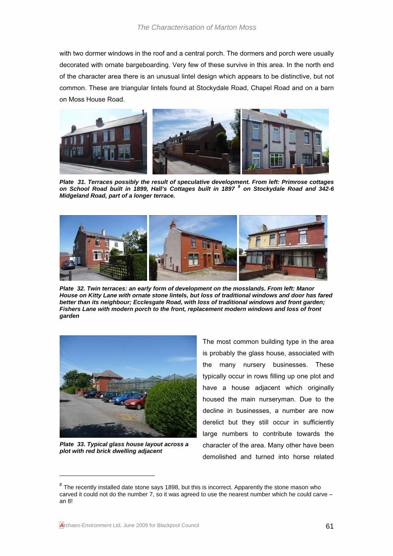
The Characterisation of Marton Moss
Archaeo-Environment Ltd, June 2009 for Blackpool Council 61
with two dormer windows in the roof and a central porch. The dormers and porch were usually decorated with ornate bargeboarding. Very few of these survive in this area. In the north end of the character area there is an unusual lintel design which appears to be distinctive, but not common. These are triangular lintels found at Stockydale Road, Chapel Road and on a barn on Moss House Road.
Plate 31. Terraces possibly the result of speculative development. From left: Primrose cottages on School Road built in 1899, Hall’s Cottages built in 1897 8 on Stockydale Road and 342-6 Midgeland Road, part of a longer terrace.
Plate 32. Twin terraces: an early form of development on the mosslands. From left: Manor House on Kitty Lane with ornate stone lintels, but loss of traditional windows and door has fared better than its neighbour; Ecclesgate Road, with loss of traditional windows and front garden; Fishers Lane with modern porch to the front, replacement modern windows and loss of front garden
The most common building type in the area is probably the glass house, associated with the many nursery businesses. These typically occur in rows filling up one plot and have a house adjacent which originally housed the main nurseryman. Due to the decline in businesses, a number are now derelict but they still occur in sufficiently large numbers to contribute towards the character of the area. Many other have been demolished and turned into horse related
8 The recently installed date stone says 1898, but this is incorrect. Apparently the stone mason who carved it could not do the number 7, so it was agreed to use the nearest number which he could carve – an 8!
Plate 33. Typical glass house layout across a plot with red brick dwelling adjacent

The Characterisation of Marton Moss
businesses, saw mills, garden centres and caravan parks.
Plate 34. Triangular lintels make a brief but distinctive appearance in this character area; Rosehill Cottage on the right is only just inside character area 2.
The use of decorated bargeboarding and ornate finials continued into the 20th century and appear on bungalows and 1920s houses. Early 20th century styles harked back to earlier times with the use of Victorian ornamentation, often combined with styles from Tudor times onwards to create an effect of age. Bungalows by their very nature are the start of an individual style that is no longer vernacular, but the continued use of such terracotta detailing has helped them to fit into the historic character of the area. Brick has also continued in use into the 20th century, although many developments dating from the 1970s failed to take account traditional building styles or local distinctiveness. The 1930s also saw the introduction of red pantiles for roofing and in more recent years, the use of concrete render has changed the appearance of many brick buildings and is probably also causing maintenance problems.
Plate 35. 20th century styles started with relatively modest styles including villas with design features from early England, in this case on the corner of Division Lane and Queensway, stone mullions and lead diamond glazed windows. Bungalows were built from the 1930s some with ornate bargeboarding and finials, this one (centre) at Midgeland Road, some with more traditional features, this one on Moss House Road (right). Most have suffered from alterations ranging from the loss of traditional window styles to the more radical which masks the original design (see right picture, left hand house)
There is no one dominant architectural style along the lanes representing the mid to late 20th century. Instead styles are highly individualised and bear no relation to English architectural history. Styles are borrowed from far and wide and often have more in common with Spanish
Archaeo-Environment Ltd, June 2009 for Blackpool Council 62

The Characterisation of Marton Moss
haciendas than Victorian villas. Most are detached houses set well back from the road, some with ornate lamps, water features and wide drives.
Plate 36. Some of the individual styles of the mid to late 20th century
The details
Plate 37. Modern, but added detail which contributes towards character and makes a place more fun to be in
It is often the small details that give a place character and while they don’t have to be old, they can be fun and quirky. Where they are old they give a sense of time depth and this is particularly important in the Amounderness Plain where one of its nationally identified characteristics is a lack of links to the past. It is even more important in this character area where so many of the buildings are hidden behind high hedges and walls. The most visually dominant feature in any development in this area is the boundary wall and entrance gates which may be the only part of the development visible. High fences or hedges predominate and gateposts with ornate tops, usually horse heads or similar and ornate wrought iron gates, often automated. Gateposts are an interesting feature and survive even where the house has been replaced or modernised. Stone built styles, also popular within Blackpool itself, are common as are a more simple stone or concrete style used on some terraced houses. What is in the garden is also a major contribution towards character particularly when the front gardens are very large. Palm trees are popular not just in private gardens but also at the front of nurseries.
Gateposts
Plate 38. A typical selection of gateposts from this character area
Archaeo-Environment Ltd, June 2009 for Blackpool Council 63

The Characterisation of Marton Moss
Other boundary treatments
Plate 39. Many of the boundary walls around private dwellings in this character area are designed to display wealth or protect privacy
Plate 40. Small details which are either a link to the past such as the boundary stone, older ornate style of lampposts, K6 telephone boxes, decorated bargeboards, datestones and street names or just fun (see the gargoyle on the kneeler) contribute towards a sense of character.
Threats, negative features and opportunities for change
This area has the highest density of 18th and 19th century buildings in the study area, but they are threatened by a gradual loss of traditional features such as windows and doors. Only one terraced house was identified which had retained these traditional features (Wayside on Kitty Lane, see plate 30). This contrasts with the survival of decorated bargeboarding which has survived well throughout the study area and is particularly characteristic of it. There have also been more extreme examples of modernisation where the original house is barely recognisable.
Plate 41. Buildings which merit closer inspection and possible inclusion on a local list: Worthington Road (modernised); The Pod on Midgeland Road; 232 on Common Edge Road
This is not a new threat. The cobbled buildings which were once so common in this area are now few in number but because many have been encased in brick and/or rendered they are not always possible to identify. Within this character area, The Pod on Midgeland Road would
Archaeo-Environment Ltd, June 2009 for Blackpool Council 64

The Characterisation of Marton Moss
benefit closer inspection and possible listing, as would the thatched cottage on Worthington Road. Midgeland Farm is a well known cobbled construction and may merit listing. Its repair and conservation should be seen as a high priority as it is one of the key historic buildings in the area. Another historic building is also falling into disrepair just off Division Lane. Worther House was a fine 19th century villa complete with carthouse, laundry and coal store and several acres of nursery. It has been uninhabited for many years and requires urgent remedial repair which should include the retention of traditional fixtures and fittings. It may be possible to fund this through enabling development nearby.
Plate 42. Buildings under threat: Worthen House off Division Lane (left) the barn on Moss House Road, Midgeland Farm and an ominous pile of cobbles next to a new house on Ecclesgate Lane and a brick cart shed – was this one that got away?
The character area still has a number of eyesores. Next to Worthen House, a former nursery has passed through a series of owners and uses resulting in a derelict and unsightly group of buildings which are a poor introduction into the road. Similar areas of waste and neglect are to be found on a number of plots, but in some cases this could be considered to be part of the character of any rural area and future development should not necessarily create a manicured appearance more suited to a modern housing estate. A balance needs to be obtained between charming rural neglect and obvious eyesore. Much can be done by giving greater consideration to boundary treatment. Hedges are the traditional form and also provide opportunities to create wildlife corridors. Boundaries such as barbed wire, tall solid fences, artificial stone and cladding contribute little to the area.
Plate 43. Some plots have been through a number of changing land uses resulting in badly maintained buildings of poor quality; these plots could benefit from a change of use. Other plots in some cases are moving from gentle neglect to eyesore. However much could be done to retain the rural charm of the area if more consideration was give to appropriate boundary treatments.
Archaeo-Environment Ltd, June 2009 for Blackpool Council 65

The Characterisation of Marton Moss
Development in this area has been of a piecemeal nature which compares to the piecemeal enclosure of the field system which provides the framework. However the range of styles varies from the uninspired to the thoughtful, from the unobtrusive to the jaw droppingly ostentatious. Such a mix is not necessarily a problem and creates an interesting mixture, but the styles only occasionally make an attempt to relate to the wider environment. Any future development within this character area has the opportunity to be creative while exploring the use of red brick, ridge tiles, bargeboarding and a similar scale to fit in with traditional styles, or it has the opportunity to create a new vernacular for the mossland built from sustainable materials and energy sources in the way that reflects the origins of development in this area in the 18th century with locally available materials. In either case the original field boundaries should be retained as a link with the past, as wildlife corridors and as a way of softening the effects of development.
Character Area 2. Walker’s Hill
Character in a nutshell: gradual hillside affording some distant views, old houses, some modernised and neglected, derelict farm buildings, dumped building materials, caravan sites, ancient historic landscape, traffic noise, quiet lanes, and donkeys
Streetscape, views and open spaces
This character area is more open than the mosslands below, sitting on a hillside which being drier than surrounding land, was occupied and exploited earlier than the rest of the mossland to the south. Around Runnell Farm in particular the landscape has an ancient feel to it with curved boundaries enveloping meadowland and old farm buildings (see plate 46). The rising nature of the land affords some distant views, not often possible within the hedgelined lanes of the mossland. Unfortunately this also affords views to the former railway line which is now the Yeadon Way. Being positioned on a raised revetment, the traffic noise is all the louder and more visible. Degradation of this ancient landscape appears to have spread from here as if it has become forgotten and neglected.
Plate 44. Unsympathetic boundary treatment, poor landscaping and a lack of maintenance have introduced a feeling of neglect around Whalley and Lilac Farms
Archaeo-Environment Ltd, June 2009 for Blackpool Council 66

The Characterisation of Marton Moss
The southern boundary of this character area is Chapel Lane, which is a fast road, but with good views across pasture and the promise of something interesting in the views along its west end. A small stretch of cobbled wall and a grotto like shed (modern?) on the roadside suggests an interesting past, views across to Rosehill Cottage and Runnell Farm, promise interesting architecture and history, but as the road heads towards the east it starts to move into a new character area of a more open landscape and where the less attractive aspects of the 21st century are encroaching including electricity pylons and industrial buildings.
Plate 45. A relict piece of cobbled walling along Chapel Road (left), as the views move eastwards they become more open and look towards a modern industrialised landscape (centre and right)
The buildings
There is a curious mixture of buildings in this character area. There are more agricultural buildings present than elsewhere on the mosslands, presumably due to a longer farming history. However with the exception of Runnells Farm, the historic interest of some of the buildings is well-disguised. Runnells Farm has been on maps since at least 1839 (Tithe map) and could conceivably be one of the farms shown on the 1700 map (figure 4). The field system around it appears to be pre-18th century, possibly 16th century. While the house has been modernised, effectively masking evidence of an earlier building, the outbuildings have been subject to less treatment and on the ground floor the building materials may be cobble. The outbuilding roof is of corrugated iron, a popular replacement for thatch. This building merits further examination and possible inclusion on the local list or as a potential listed building. The quality of the historic building stock improves towards Stockydale Road with some thatch and a rare Victorian detached house with traditional features (see Local List recommendations).
Archaeo-Environment Ltd, June 2009 for Blackpool Council 67

The Characterisation of Marton Moss
Plate 46. Runnell’s Farm showing signs of being a possible cobbled building and set within an anciently enclosed landscape
Other farms in the area include Whalley Farm and Lilac Farm. Once again these properties have been over-restored, thus masking evidence of anything of historic interest. Their concrete render may create problems with damp and they sit within an uninspiring streetscape and landscape with a large number of eyesores present. However Whalley Farm appears to have been a cobbled building which was subsequently encased in brick (Monks 1986, 26). It has since been unsympathetically modernised with picture windows, plastic door and concrete render, all of which are reversible. Lilac Farm is surrounded by building debris and rubbish which detracts considerably from the building. It sits behind a willow tree and concrete brick fencing which combined with the pebble dashed coating, does much to masks the fact that this is probably quite a fine building. The porch proudly carries the name of the farm above the doorway. Another curious building within the farmyard area is a wooden and brick structure which appears to be used for storage but which may be a left over from when the Yeadon Way was a railway. At least two other brick buildings in this area may have similar origins.
Archaeo-Environment Ltd, June 2009 for Blackpool Council 68

The Characterisation of Marton Moss
Plate 47. Whalley Farm Before and….
Plate 48. After
Archaeo-Environment Ltd, June 2009 for Blackpool Council 69

The Characterisation of Marton Moss
Plate 49. A glimpse of Lilac Farm through the willow trees (left) and the adjacent former railway building (?); 19th century farm buildings along Chapel Road combined with old cobble walls add historic interest, while Rosehill Cottage is one of the few to represent the Victorian cottage (now extended and modernised) with dormer windows and bargeboarding and the typical brick and stone mix. The eye catching window lintels are unusual and reflect the shape of the dormers. Similar window lintels can be seen on Moss House Road and Stockydale Road
The details
There are few interesting details in this character area and those which do exists are on Chapel Road, the boundary of this character area and arguably more suited to the mosslands character area.
Plate 50. New cobbled buildings, farm buildings, decorated finishings to properties along Chapel Road and a reused fingerpost on Cropper Road (just inside character area 1) offer some features of interest, but the overall character of the area is one of neglect, possibly made worse or caused by the proximity of the modern Yeadon Way and growing industrial estates.
Threats, negative features and opportunities for change
Land between Whaley Farm, Lilac Farm and Yeadon Way has deteriorated and has become an eyesore. The proximity of caravan parks with poor landscaping, badly-modernised historic buildings and poor boundary treatment do little to enhance the area.
Plate 51. Neglect, dumping and poor landscaping do much to detract from this character area which has the historic infrastructure in the form of ancient enclosures and historic buildings to have much more historic character
Archaeo-Environment Ltd, June 2009 for Blackpool Council 70

The Characterisation of Marton Moss
Character Area 3. Wild Lane
Character in a nutshell: open space, flat and featureless landscape, electricity pylons, straight narrow road, passing places with dumped materials, straight shelter belts and modernised post medieval field pattern
Streetscape, views and open spaces
Wild Lane stands out in the landscape for its ruler straight approach typical of a field boundary surveyed into the post medieval landscape in the 19th century. This combined with a lack of hedgerows or walls creates a relatively featureless landscape within which any vertical structures stand out, in this instance electricity pylons, road traffic signs and the shelter belt. This is in stark contrast to the mosslands to the west which are much more enclosed. The lack of undulations allows for long views, but for the most part these are relatively dull, simply consisting of the airfield’s radar pylon and distant electricity pylons. This featureless landscape overlies an earlier post medieval landscape which was more subdivided, but there is no evidence that it was ever populated with buildings or hedgerows.
Plate 52. Views across this character area are relatively featureless
The buildings
There are no buildings in this character area.
The details
There are no historic or architectural details in this character area
Threats, negative features and opportunities for change
This prairie like landscape has little of historic character and is a common landscape type within lowland UK. It is therefore not sensitive to change and offers a blank canvas with which to change its character by improving its wildlife and landscape value and to create a new vernacular for the area.
Archaeo-Environment Ltd, June 2009 for Blackpool Council 71

The Characterisation of Marton Moss
Character Area 4 Whitehill and Cropper
Character in a nutshell: nursery gardens, caravans, high hedges, narrow roads, creeping industrialisation/commercialism, electricity substation and pylons, noisy traffic, red brick houses set back, modernised enclosure landscape, palm trees
Streetscape, views and open spaces
This is a landscape set out in the 19th century, but which has since seen some amalgamation of field boundaries and the imposition of major arterial roads centering on a large roundabout and industrial estates. High hedgerows remain along parts of Peel Road, Cropper Road, Old House Lane and Whitehill restricting views from the roadside, but gaps still afford views across paddocks and these open pasture fields remain an important part of the character of this area as well as all other mossland character areas. The roads open out towards the south of Peel Road affording long views of a flat landscape,
marred somewhat by an electricity sub station and pylons. The approach into this character area is dominated by industrial sized buildings, large roads and poor quality boundary treatment. The
proximity of this modern industrial scale development to quiet rural agricultural holdings creates a contrast of styles and a clash of time periods.
Plate 53. A secluded right of way near Old House Farm with derelict glasshouses adjacent
Plate 54. Cropper Road (left), like Whitehills and Peel Road start off hedge lined with occasional views into paddocks (centre) and caravan parks. Around the edges of this character area the old meets the new in contrasting styles and scale at Old House Farm (right)
The buildings
The majority of buildings in this character area date from the mid to late 20th century and are built of red brick in varying shades or are rendered or pebble dashed (a few 1930s buildings combine both). Some other new build makes no attempt to acknowledge local building styles or materials. Styles vary from semi-detached houses and bungalows to detached
Archaeo-Environment Ltd, June 2009 for Blackpool Council 72
Plate 55. One of two neglected 1930s buildings along Old House Lane

The Characterisation of Marton Moss
houses, mostly set back from the road. Those on Peel Road are not all surrounded by high walls or hedges as in other parts of the mosslands, but those on Whitehills and more secluded. Most are one or two storeys high with chimneys and slate roofs. There is a small smattering of 19th century build at Pipers Height which also has new build in brick with stone finishings which fit into the existing architectural styles. Further south near the electricity sub station there is also an ornate 19th century building of unknown function. Old House Farm appears to be late 19th century with tall bargeboarded gables and built, like most other buildings, in red brick. It is overlooked by modern buildings on Hallam Way. Garden centres remain predominant with sheds, glasshouses, car parking and retail buildings, although some have now been abandoned. It is not only glasshouses which have become derelict in this area; 1930s houses along Old House Lane also show the signs of neglect.
Plate 56. The majority of buildings use the same red brick in varying shades within this character area, but render is also used to a lesser extent, but does not always fit into the existing character. The scale of buildings is relatively modest with farm buildings at Pipers Height (right) and Old House Lane being the largest.
The details
This character area has lost many of the small historic details which add interest to an area. However down the little lanes there are surviving old gateposts, while older traffic signs have survived through neglect. New build is beginning to incorporate little flourishes such as ornate gateposts, but for the most part, the architecture lacks ornamentation. Nurseries still play a key role in defining the character of the area, not least because of the number of signs they display outside, competing for passing trade. Palm trees make a regular appearance in gardens and nursery forecourts.
Plate 57. A broken 1920s street sign (left) and a forgotten gatepost (right) are one of a few remaining historic details along with the hedgerows and narrow roads.
Archaeo-Environment Ltd, June 2009 for Blackpool Council 73
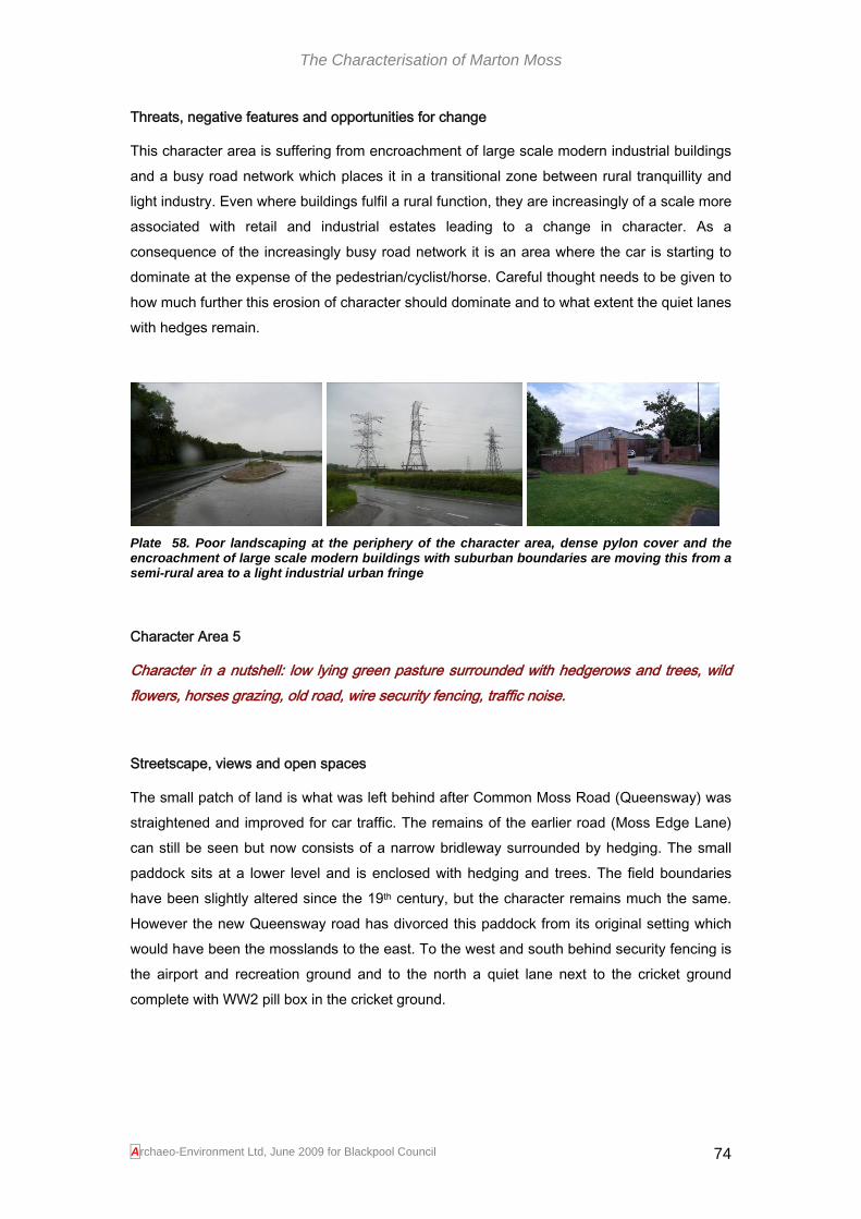
The Characterisation of Marton Moss
Threats, negative features and opportunities for change
This character area is suffering from encroachment of large scale modern industrial buildings and a busy road network which places it in a transitional zone between rural tranquillity and light industry. Even where buildings fulfil a rural function, they are increasingly of a scale more associated with retail and industrial estates leading to a change in character. As a consequence of the increasingly busy road network it is an area where the car is starting to dominate at the expense of the pedestrian/cyclist/horse. Careful thought needs to be given to how much further this erosion of character should dominate and to what extent the quiet lanes with hedges remain.
Plate 58. Poor landscaping at the periphery of the character area, dense pylon cover and the encroachment of large scale modern buildings with suburban boundaries are moving this from a semi-rural area to a light industrial urban fringe
Character Area 5
Character in a nutshell: low lying green pasture surrounded with hedgerows and trees, wild flowers, horses grazing, old road, wire security fencing, traffic noise.
Streetscape, views and open spaces
The small patch of land is what was left behind after Common Moss Road (Queensway) was straightened and improved for car traffic. The remains of the earlier road (Moss Edge Lane) can still be seen but now consists of a narrow bridleway surrounded by hedging. The small paddock sits at a lower level and is enclosed with hedging and trees. The field boundaries have been slightly altered since the 19th century, but the character remains much the same. However the new Queensway road has divorced this paddock from its original setting which would have been the mosslands to the east. To the west and south behind security fencing is the airport and recreation ground and to the north a quiet lane next to the cricket ground complete with WW2 pill box in the cricket ground.
Archaeo-Environment Ltd, June 2009 for Blackpool Council 74

The Characterisation of Marton Moss
Plate 59. The former Moss Edge Lane is now a footpath and bridleway (left) and another lane forms the northern boundary (centre), but both have intrusive security fencing. The paddock sits at a lower level than the new road and the fields from the west suggesting that it has gone through some shrinkage through peat extraction and drainage
Buildings
There are no buildings in his character area
Details
There are no particular historic features of interest in this character area apart from the lane itself. The adjacent pillbox, outside the study area, should be recorded and protected from any road widening.
Threats, negative features and opportunities for change
This small patch of land is now sandwiched between a busy road and the airport perimeter divorcing it from its original agricultural setting. The bridleway through the hedging and wildflowers offers a quiet alternative to the urban road and therefore has amenity value, but the use of security fencing and traffic noise are intrusive modern elements which detract from the pastoral character. As the plot is now isolated it is less sensitive to change, but consideration needs to be given to retaining a rural path through the area as an alternative to dodging cars on Queensway.
Maintaining, enhancing or creating local distinctiveness in the study area One of the characteristics of this national character area (JCA 32) is the lack of visual hooks to our past. In this area that is partly because the past did not offer the conditions necessary for prolonged settlement except on a few ridges of drier ground until the 18th and 19th centuries. It is also because the poverty of the mosslands meant that structures were often ‘jerry built’ and not conducive to survival. However within the urban conurbations, it is also because there has been a long history of demolition so that the developer was faced with a blank slate. Research by English Heritage has shown that there is a strong association between places with a well-maintained tangible past with a good quality of life and economic well-being. With this in mind, the local distinctiveness of the Moss area has been examined
Archaeo-Environment Ltd, June 2009 for Blackpool Council 75
The Characterisation of Marton Moss
and below are a number of historic features or elements which could be used to enhance historic character and ensure that if rapid change does take place it continues to be associated with a ‘cherished local scene’. This will help new development to conform to County Structure Plan 6.4.2 which seeks to identify and retain local distinctiveness and the aims of the Blackpool Local Plan, ‘To lift quality in the built environment by encouraging sustainable, innovative and high quality urban design in new developments…’ (Blackpool Council 2006, 46). The field pattern The field pattern should be retained, particularly within the mosslands character area (character area no.1). This will allow the hedgerows to be maintained and enhanced (and require the maintenance of the ditches), softening the impact of change and providing the opportunity for wildlife diversity. This will help to conform to County Structure Plan Target 20.1 seeking no net loss of hedgerows. The paths which run alongside the enclosures should also be retained as public rights of way offering continued amenity value and an escape from modern living. Some plots should be retained as open space in order to minimize the impact of change and retain some open views through gaps in the hedgerows. The field pattern around Wild Lane and Whitehills/Cropper (character areas no. 3 and 4) have been through more change and are therefore less sensitive to future change. The ancient landscape around Runnells Farm is however sensitive to change, but immediately around Lilac Farm and Whalley Farm it has deteriorated to such an extent that change is desirable. Resources/Energy The area has a tradition of using sustainable materials (locally made brick, reeds for thatching and cobbles). This could inspire new development to aim for equivalent sustainability. The Fylde was known as windmill land and in addition to the remaining windmill, there are already a number of vertical modern features in the landscape such as pylons and shelter belts. Sustainable sources of energy could be explored for any new development. Building Materials The area has a wide range of building materials and varying designs, many of which lack local distinctiveness. However the traditional material used (excluding cobbles) was red brick, often a variety of reddish colours in one elevation creating an attractive and varied surface. The Victorian styles were not overly ornamental and there is little from the neo- Gothic styles which they became famous for. However care has been taken to provide some design detail such as ridge tiles and decorated bargeboarding which is particularly distinctive in this study area. The diluting of local distinctiveness through the introduction of an eclectic mix of mid to late 20th century designs has detracted from the historic character, but does offer an opportunity to create a new vernacular for the mosslands using sustainable materials to create modern innovative designs which fit into their environment. These designs can borrow
Archaeo-Environment Ltd, June 2009 for Blackpool Council 76

The Characterisation of Marton Moss
from the past, but need not create pastiches of Victorian development. The use of glass could also reflect the recent use of much of this land for market gardening. Scale The scale of existing buildings is dominated by detached two storey houses, terraces and semi-detaches with occasional cottages which have survived from the 18th and 19th centuries. This gives a broad choice of styles for future development, but should be targeted where they fit best into existing character. For example terraced housing would fit best along the busy arterial roads, but should be restricted to small groups within the mosslands (character area 1). Communications Creating an adequate communications network is going to create particular challenges for this study area. The quiet rural lanes of un-made road surfaces with high hedgerows on either side are not well suited to increasing traffic. They are however essential to the historic character of the area and where the road network has been improved around the periphery, it has been to the detriment of the historic character resulting in divorcing quality buildings from their settings and reducing the use of the area by pedestrians. Any changes in the study area should seek to retain the rural road network and leafy lanes, particularly in character area 1. This would fit in with policy LQ3 in the Local Plan and the requirement for any new development to put the needs of pedestrians and cyclists first. By restricting the use of the lanes they could remain safe havens for non-car use and retain the very qualities which have attracted people to the area. If the road network is improved to meet modern highways requirements it will lead to an unacceptable degradation which is already underway in character areas 2, 4 and 5. Where old street signs remain they should be retained, traffic signs, street lighting and road markings should be kept to a minimum in the quiet lanes and resurfacing a low priority. Existing historic buildings stock This should be retained and by using quality design in any new build, it is to be hoped that more appropriate windows and doors will be used on the existing historic buildings as they are replaced. Where old buildings are purchased for redevelopment, the traditional features such as window mullions and ridge tiles should be retained. In order to help achieve this, those buildings included in the proposed local list (see Appendix A) or listed, should be recorded with historic analysis carried out prior to development decisions being made; this will help to identify what features should be retained and also help to identify earlier buildings encased within later ones. This may also require some historic building recording during works so that intrusive recording can take place and provision has been made for this in PPGs 15 and 16. The association between the residential house and cart shed should also be retained, although the cartshed will undoubtedly make the transition to a garage easily. The
Archaeo-Environment Ltd, June 2009 for Blackpool Council 77

The Characterisation of Marton Moss
association with glasshouses will less easily survive as nurseries sell up for development, but as a long term strategy for the area, some nurseries should be retained as a link to the past and the wholesale shift of this trade to another area would be an unwelcome loss of character.
Archaeo-Environment Ltd, June 2009 for Blackpool Council 78

The Characterisation of Marton Moss
Bibliography
Architectural History Practice 2008 Characterisation Assessment, Raikes, Blackpool (Draft)
Cheshire County Council 2008 The Cheshire Historic Landscape Characterisation
Countryside Quality Counts http://countryside-quality-counts.org.uk/. Accessed 30.6.09
Gelling, M 1984 Place-Names in the Landscape
Ede, J with Darlington, J 2002 Historic Landscape Characterisation for Lancaster. Lancashire County Council
English Heritage 2009 http://www.english-heritage.org.uk/server/show/nav.00100200400d001. Accessed 14.6.09
Lancashire County Council Structure Plan
Lancashire County Council 2000 Landscape Character Assessment
Lancashire County Council with Egerton Lea 2005 Blackpool Historic Town Assessment Report
Lancashire County Council with Egerton Lea 2006 Lytham St Annes Historic Town Assessment Report
Middleton, R, Wells, CE and Huckerby, E 1995 The Wetlands of North Lancashire
Monks, H 1984 Marton: A Century of Change
Monks, H 1986 Marton: A Domesday Village
Monks, H 1996 Marton Moss and its Neighbourhood
Moore, N 2009 Blackpool and District. Now and Then
Muir, R 2000 The New Reading the Landscape
Newman, R and Hardie, C 2007 The Cumbria Historic Landscape Characterisation Project: The Lake District National Park
Porter, J 1876 History of the Fylde of Lancashire
Rackham, O 1990 The History of the Countryside
Rippon, S 2004 Historic Landscape Analysis
Rothwell, C 1994 Blackpool in Old Photographs
Sparks, J 2007 A Portrait of Blackpool and The Fylde
Thornber, W 1838 History of Blackpool and District
VCH 1966 A History of Lancashire vol VII
Archaeo-Environment Ltd, June 2009 for Blackpool Council 79
The Characterisation of Marton Moss
Walton, J K 1978 The Blackpool Landlady
Walton, J K 1998 Blackpool
Winchester, A 2006 England’s Landscape: The North West
Williamson, T 2002 The Transformation of Rural England
Archaeo-Environment Ltd, June 2009 for Blackpool Council 80

The Characterisation of Marton Moss
Archaeo-Environment Ltd, June 2009 for Blackpool Council 81
Appendix A
National Significance of Historic Buildings and the Local List Policy 21 of the County Structure Plan seeks to identify whether features are nationally, regionally or locally important and to this end the significance of each historic building identified has been assessed as follows: Nationally Important By their very designation, listed buildings whether Grade I, II or II* are considered to be nationally important in the Structure Plan (p82, table 6). However English Heritage considers that some Grade I buildings might be internationally important (English Heritage accessed 14.6.09). The following are therefore considered to be nationally important. Walker’s Hill Farm (outside the study area) Blowing Sands (No. 166 Comon Edge Lane) 1-2 Fishers Lane The location of these nationally important buildings are located on figure 19 and are as follows: Listed buildings
SD 33 SW BLACKPOOL COMMON EDGE ROAD
3/7 No. 166 (Blowing Sands) and attached
Wall to north
II
Pair of cottages, now one, probably late C18, with adjoining mid-C19 workshop. Cobble and brick with slate roof. 2-unit plan with gable chimney stacks. 2 very low storeys at the front, with continuous single-storey outshut under cat-slide roof behind. Plain doorway right of centre, and 2 roughly square windows on each floor, 3 with sliding sashes. Right gable wall is of cobble up to eaves level, rendered above. There is a garden wall of coursed cobbles with brick lacing c. 2 metres high to the left (north) side of the house, with workshop backing onto it. Rear wall of outshut is of cobble left of central doorway and brick right of it; 3-light wooden-mullioned window on the left, sliding sash on the right. Interior: partition works of cobble; original roof timbers.
Listing NGR: SD32779 32301
SD 33 SW BLACKPOOL MIDGELAND ROAD
3/19 Walker's Hill Farmhouse
and attached barn and
shippon
- II
Farmhouse (unoccupied at time of inspection, October 1989).9 Last quarter of C18. Cobbles with some brick; roofs originally thatched, now corrugated iron (over house). Slate and corrugated asbestos over barn/shippon. Plan: house with parlour/kitchen with 2 small service rooms; barn and shippon attached (but of different build, possibly c.1800). House, 2 storeys, regular 2-window range with door to left; all windows with Yorkshire sashes. Rear with 2 ground-floor windows. Barn with large waggon doors and door to shippon; rear projects beyond line of house. The shippon roof is partially collapsed. Interior: remarkably intact fittings and plan. Flag floor; 2 shallow-chamfered ceiling beams with original joists; brick baffle (or heck) partition. Slightly lower iron fire surround with decorative panels and paterae; Victorian range (by Hallmark & Gill of Blackpool). Winder stair to rear. Service rooms divided by axial partition; simple sunken panel doors with strap hinges throughout. The first floor retains its early low 9 Now restored and for sale

The Characterisation of Marton Moss
rchaeo-Environment Ltd, June 2009 for Blackpool Council A 82
partitions, planked, the doors with strap hinges. Roof: side purlins and ridge piece. The house is divided by a full height division. A rare survival of a C18 Fylde cobble-built farmhouse (the only one surviving in Blackpool District).
Listing NGR: SD33122 33284
********************************************************************************************
SD 33 SW BLACKPOOL FISHERS LANE
3/9 Nos 1 and 2
II
The description shall be amended to read:
Pair of single-storey cottages, date uncertain but probably late C18. Cobblestone and brick, with roofs of thatch, corrugated metal sheet, and slate. Each is essentially a single-unit plan with gable-end chimney stack; No 1, recently re-thatched, has a rear extension under cat- slide roof, and a modern flat-roofed extension to left-hand side. No.2 has rear extension of brick with roof of corrugated sheet, and low side- extension with slate roof. Doors of both are close to gable ends, that of No.1 with modern gabled porch; both have two rectangular windows in front wall, all with modern frames. No. 2 has a very small square window in the rear wall, close to the end walls, perhaps originally to light the hearth. Listed as now rear (sic) examples of single-storey cobble- walled dwellings.
SD 33 SW BLACKPOOL FISHERS LANE (old description)
3/9 Nos. 1 and 2
II
Old description: Pair of single-storey cottages, date uncertain but probably late C18.
Cobblestone and brick, with roofs of thatch, corrugated metal sheet, and slate. Each is essentially a single-unit plan with gable-end chimney stack; No. 2, recently re-thatched, has a rear extension under cat-slide roof, and a modern flat-roofed extension to left-hand side. No. 1 has rear extension of brick with roof of corrugated sheet, and low side-extension with slate roof. Doors of both are close to the gable ends, that of No. 2 with modern gabled porch; both have 2 rectangular windows in front wall, all with modern frames. No. 1 has a very small square window in the rear wall, close to the end walls, perhaps originally to light the hearth. Listed as now rare examples of single-storey cobble- walled dwellings.
Listing NGR: SD32919 32192 – Fishers Lane
********************************************************************************

The Characterisation of Marton Moss
Archaeo-Environment Ltd, June 2009 for Blackpool Council 83
Figure 19. Location plan of listed buildings

The Characterisation of Marton Moss
Other nationally important buildings There is at least one K6 type telephone kiosk in the area on Midgeland Road (NGR SD34127 31654). This is one of a series designed in 1935 by Sir Giles Gilbert Scott and made by various contractors in cast iron with a square kiosk and domed roof decorated with unperforated crowns to the top panels and margin glazing to windows and door. These are often listed in other parts of the country and county and for consistencies sake should be added to the list of historic buildings of architectural of historic interest for Lancashire, as grade II buildings. Another one nearby is no longer in its original location and is therefore not recommended for listing (outside Rose Villa roughly at SD 3409 3174).
The farm at Midgeland ( NGR SD 33935 31930) may also be worthy of listing as it appears to be an early structure and although it is in poor condition, it almost certainly contains remnants of a building going back
as far as the 18th century, and possibly the 16th century. Building recording and analysis should take place in order to inform any future development or restoration and whether it does contain sufficient historic interest to merit listing.
Plate 60. K6 telephone box on Midgeland Road
Plate 61. Midgeland Farm in 1985 (left) and in 2009 (right). The corrugated roofing was obviously placed over existing thatching. There has been considerable deterioration while in County Council ownership
Regionally Important Conservation Areas, important hedgerows (defined by the Hedgerow Regulations 1997) and sites of archaeological interest are considered to be of regional or county wide importance. Sites of archaeological interest recorded on the county HER are shown in appendix C. Hedgerows in the study area have not been included under the Hedgerow Regulations but recommendations in this report are to maintain them as part of any new proposals, particularly in character area 1 – the mosslands.
Archaeo-Environment Ltd, June 2009 for Blackpool Council 84

The Characterisation of Marton Moss
Locally Important These buildings contribute towards local distinctiveness in the area but have no statutory protection. They do however have a number of design features which should be retained as part of their on-going maintenance and can be used to inspire modern designs to help new development fit into the existing historic character. They do not include all 19th century buildings, but if historic character is to be conserved, all 19th century buildings should be retained, and where they have lost their traditional sash windows and wooden doors, these should be replaced in due course. The twin terraces and villas are particularly important in the architectural evolution of the mosslands and along with buildings dating to the 1920s-50s contribute towards time depth. Those buildings which should be included in a local list are as follows:
Archaeo-Environment Ltd, June 2009 for Blackpool Council 85

The Characterisation of Marton Moss
Recommendations for Inclusion in Local List
Image Location Reason for inclusion
Lamppost on Midgeland Road NGR SD34127 31654 K6 telephone kiosk – see section on proposed listed buildings
Dates to first half of the 20th century (with more recent lamp?) – ornate base. Examples are usually removed and replaced as part of revised lighting schemes and is therefore under threat.
Midgeland Lane lamppost Various locations along lane at SD 34332 31457 SD 34250 31522
as above
Worthen House, Division Lane SD 33300 31437
Dates to c.1892 and now in very poor condition, but retains original fittings to exterior and association with cart house. May provide template for replacement windows etc on other late 19th century houses
Boundary stone on Mad Nook corner on Common Edge Road, originally at the end of Division Lane NGR SD 33150 31457
Probably 19th century in date and marks the historic boundary between Marton (now Blackpool) and Lytham; a boundary which originates in Anglo-Saxon times and today still marks a change in character. No longer in its original position.
Common Edge Road NGR SD 33140 31405
WW2 pillbox dating to 1940. Outside the study area, but possibly affected by any future road improvement – WW2 reinforced concrete remains now a diminishing resource
Archaeo-Environment Ltd, June 2009 for Blackpool Council 86

The Characterisation of Marton Moss
Wayside (right hand side), Kitty Lane NGR SD 33515 31760
Part of a twin terrace and therefore an important part of the architectural evolution of this area. However Wayside is the only example to retain its traditional windows and doors.
Butchers Farm Cottage?, Worthington Road NGR SD33535 31655
A modernised and extended thatched house, possibly cobbled construction with modern cobble wall. Plastic replacement windows, but retaining overall proportions with small windows and porched front door
Barn on Moss House Road NGR SD32975 32524
Late 18th or 19th century barn with ornate windows and reused stone finishings within a brick structure. An unusual building representing the earlier agricultural use of the area, now predominantly residential.
Bungalow on Moss House Road (right hand side only)
Selected because it appears to have original windows and doors
232 Common Edge Road NGR ?SD 32972 32097?
Selected on the basis of a distant view only of the side elevation, but appears to be a Victorian cottage which might retain traditional features
Southgate, Bennetts Lane Selected because of the highly ornamented nature of the brickwork, however windows are modern replacements
Former railway buildings ? at Lilac Farm approx NGR SD 33520 33467
Selected because of their possible remaining association with the railway
Archaeo-Environment Ltd, June 2009 for Blackpool Council 87

The Characterisation of Marton Moss
Farm building on Chapel Road Selected because of the positive contribution it makes to the character of the area and its link with an agricultural past
Cobbled wall on Chapel Road SD 33390 33216
Selected because this once common form of boundary wall is now rare
Runnell Farm NGR SD 33417 33315
Selected because this is an early settlement site and indications (from a distance) are that historic fabric certainly remains in the outbuildings, but may also remain within the improved house
Whalley Farm NGR ?SD33372 33475?
A badly modernised farm which may contain earlier cobbled remains within its fabric
Road sign on Stockydale Road (Halls Cottages) NGR ?SD 33407 32710?
1920s finger post ex situ and now in private ownership, but one of only three found in the study area and relatively rare nationally
41 Stockydale Road Virtually unique within the area – a detached house which has retained its traditional features and is still associated with its cart shed
Archaeo-Environment Ltd, June 2009 for Blackpool Council 88

The Characterisation of Marton Moss
Finger post on corner of Whitehill and Peel Road NGR SD35545 32862
1920s finger post, one of only three found in the study area and relatively rare nationally
Peel Road approx NGR SD 35711 32190
Interesting brick built building possibly late 19th century adds considerably to the historic character of an otherwise bleak landscape
Loretta? 20, Moss House Road
Selected for its unusual quirky 1920s? style which contributes much to the character of the area (the plastic replacement door does little to enhance the property however)
Midgeland Farm NGR SD 33935 31930
Selected as a rare historic property retaining a number of historic features and possibly worthy of listing. Building recording and analysis should be carried out as a priority before commencing a programme of restoration. (see also proposals for listing above)
Archaeo-Environment Ltd, June 2009 for Blackpool Council 89

The Characterisation of Marton Moss
rchaeo-Environment Ltd, June 2009 for Blackpool Council A 90
Appendix B
Historic Roads and Names (present on 1st ed OS map or earlier)
Chapel Road
Part of Cropper Road
Bambers Lane – William Bamber was a farmer at Bambers Farm in the early 19th century
Old House Lane
Part of the B5470 is an old road
Division Lane (see report for association with Saxon division)
Kitty Lane (named after Kitty Ellen Kirkham who lived here possibly in the 1890s? Her cottage was demolished in 1958)
Common Moss Edge (Moss Lane) (defines where the limits of cultivated land met mossland)
St Nicholas Road
Midgeland Road (Midgeland Lane) (the earliest road through the mossland)
Stockydale Lane (now New Hall Ave) – the lane go out to doles?
Ecclesgate Road
Fishers Lane – William Fisher was a farmer in the early 19th century living at a farm and cottage in Little Bispham. Could relate to this family?
Holgate
Walker’s Hill
Moss House Road
Jubilee Lane North (Victoria’s jubilee?)
Historic Place Names (present on 1st edition OS map)
Cropper
Dale Bank
Foot Stick
Moss House
Moss Side
Old Hill
Pipers Height
Runnell Farm
The Fold
Walker’s Hill

The Characterisation of Marton Moss
Appendix C
Figure 20. Location map showing Historic Environment Record sites. Although the whole area has some archaeological potential, the main clusters are around the older inhabited areas at Walkers Hill, Blowing Sands and the moss edge, Midgeland Farm and Peel Hill
Archaeo-Environment Ltd, June 2009 for Blackpool Council 91

The Characterisation of Marton Moss
Archaeo-Environment Ltd, June 2009 for Blackpool Council 92